
It is hard being a child of a famous parent. It means living under a cloud of expectation. Society expects children to be like the parents. Parents expect children to become a better version of themselves. Parental pressure can be particularly strong on the oldest child. Younger children may have more freedom to do what they want for themselves. Sometimes, the only way for a child to achieve freedom is by rebellion. They need to find fault in their parents, in society, and perhaps in their siblings. Let battle commence. Once independence has been achieved, over time the weapons are buried and relations improve. Who will achieve more, the child who follows after the parents or the one who rebels? That cannot be predicted. It also depends on who does the judging.
Volcanoes too have offspring, siblings, and even conflicts. This can be evident from the name, as in the kinship between the Three Sisters. Krakatau left us an orphaned child called Anak Krakatau (‘son of Krakatau’, in case you need a translation). Anak Krakatau is not just a mini Krakatau. It has become a respectable volcano in itself, a Stromboli look-alike with frequent, picturesque eruptions. And after that day 18 months ago, it instils fear as well. The child may share the faults of its parent, but it found its own failure. But to us, Anak Krakatau will always exist in the shadow of its parent. It has too much to live up to: its fame is its name.
(Of course, sometimes the child will become more famous than the parent ever was. But for volcanoes young enough that we can remember the parent, there hasn’t yet been time for this. They are at the start of their careers.)
There are different degrees of volcanic kinship. After a major eruption, a new volcano may grow at the location of the old one – the new generation is a clone of the parent. This is what happened at Krakatau. Alternatively, a new volcano may grow up along the caldera rim, fed from the same magma chamber but channeling the magma through the caldera fault. This happened in Sakurajima. A more extreme example would be Rabaul where several volcanoes grew up along the rim, as children huddled together. A third case is offspring from a non-destructive volcano. It can develop a side shoot, much like a tree may grow a new stem from its roots: one or more new volcanoes grow up while the old volcano happily continues. An example of this is Mount Ararat, which grew a smaller, younger version of itself 10 km away; the two are, not surprisingly, called Greater Ararat and Little Ararat.
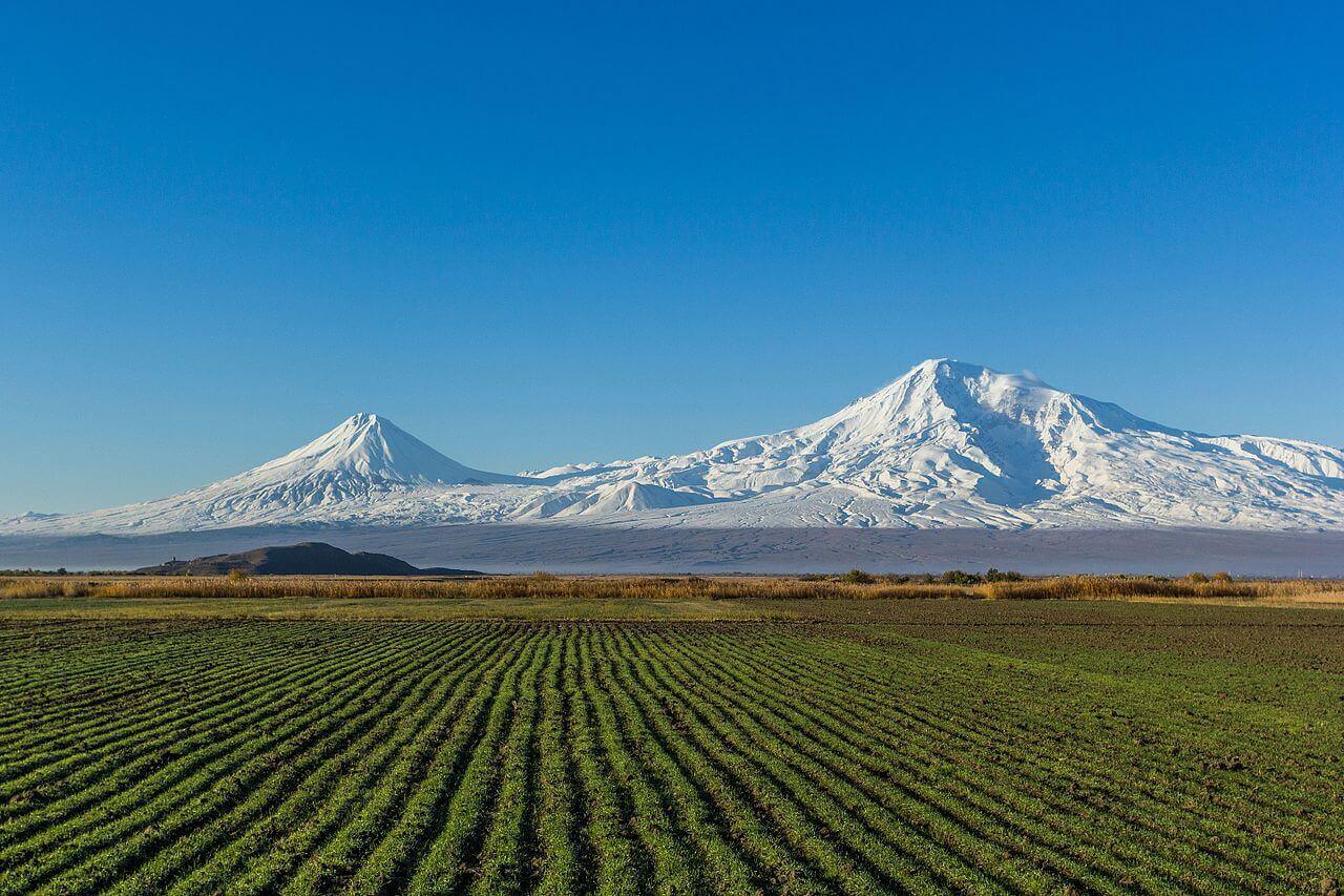
The Ararat family. Source: wikipedia
This post is about one of those odd couples: a parent and a child which are so different that the close relation was easily missed. Whether the child will follow in the parent’s footsteps is still unknown. But it is doing well.
Bougainville

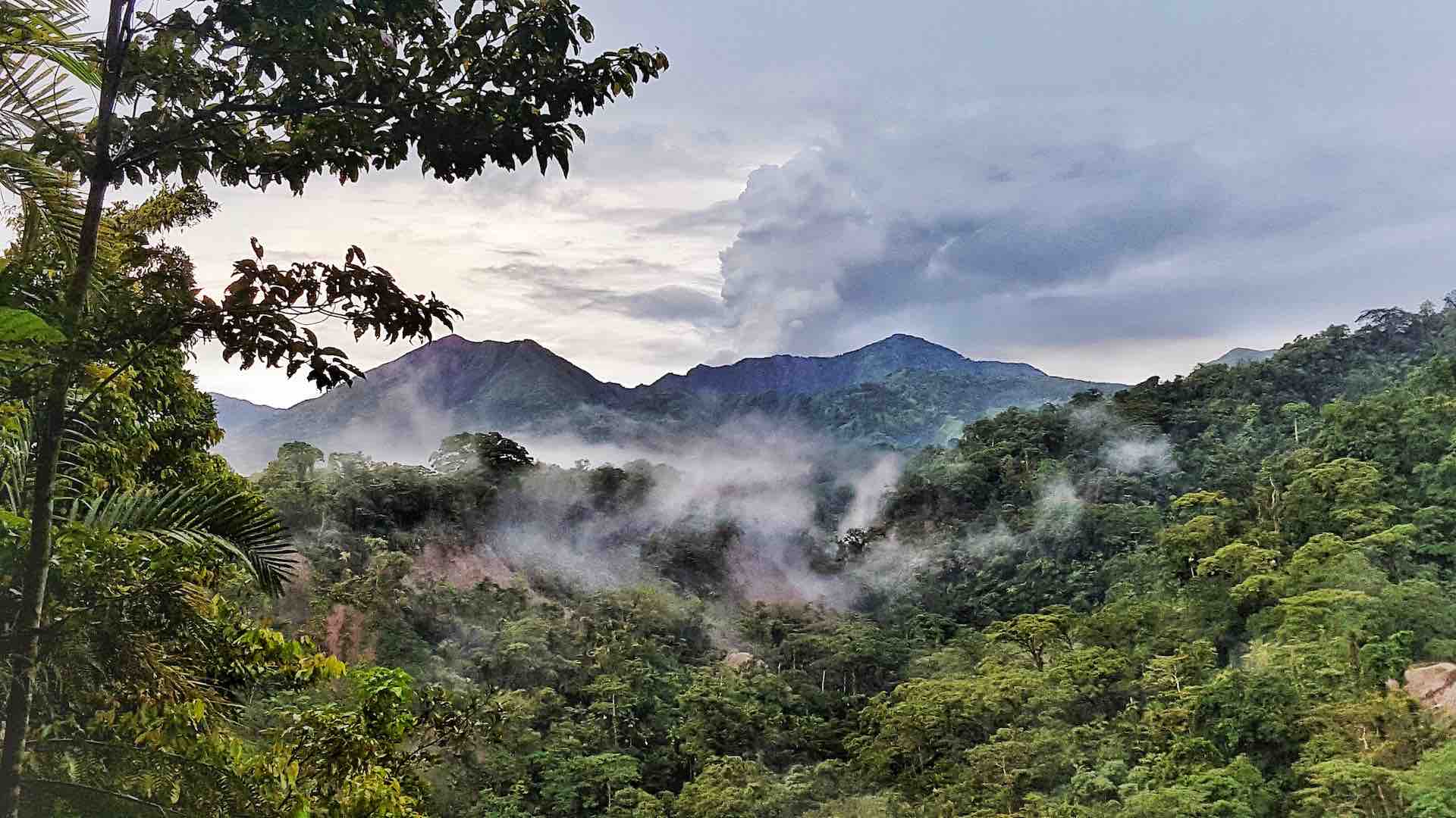
It is supposedly one of the most beautiful places in the world although you would be hard-pushed to find the tourist brochure. Bougainville is poor and poorly known, with few facilities for tourism. There is accommodation on the neighbouring Buka island, but little on Bougainville itself. The interior of the island is mountainous rain forest, difficult to penetrate and little explored. You would be well advised to only go into the interior with local guides. Be aware of the crocodiles, malaria, guns, and all other hazards of the rain forest. And know that not even hardy bird watchers go there.
If you haven’t heard of Bougainville, it is found at the northern end of the Solomon Islands, and is separated from Papua New Guinea by New Britain (don’t ask). Geologically, it is part of the Solomon Islands, and at 200 by 50 km it is the largest of these islands. Politically it is an autonomous part of Papua New Guinea.
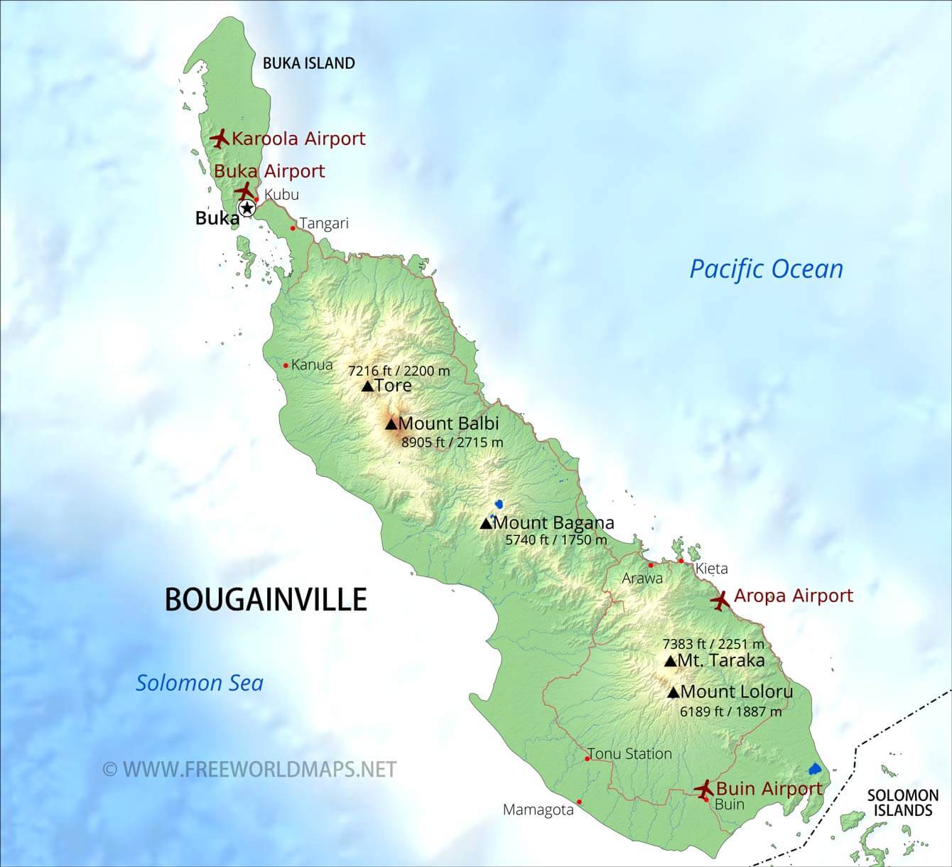
http://www.freeworldmaps.net/oceania/bougainville/
In 1988 an insurgency began against unrestrained mining, in particular an open-cast gold mine in the central regions, called, Panguna. The mine was operated by several companies working with the Papua New Guinea government and was quite profitable for all parties, but Bougainville was left with the cost and too little of the income. The Jaba river and its floodplain were comprehensively poisoned by dumped copper waste. The conflict developed into a civil war which devastated the island. At one time a blockade stopped medicines from reaching the island. A peace settlement was reached a decade later. The accord provided for a referendum on independence. This referendum took place in December 2019, and the vote was strongly in favour. Negotiations will take years but perhaps in the next decade Bougainville will become the newest independent nation. The first action it is likely to take is to re-open the Panguna mine, now with the locals benefiting from the profits. We can only hope that the environment will not be sacrificed again.
Bougainville has a long human history. The oldest archaeological finds are dated to 29,000 years ago. There was a second phase of settlement 3000 years ago, when Polynesians reached the island, but the people retain a distinct character. The skin tones are darker than anywhere else in the Pacific, and 8 of its 21 languages are Papuan and do not belong to the Austronesian languages which dominate Polynesia. However, there has been a lot of mixing and there is no clear genetic difference between the Papuan and non-Papuan speakers.
Geologically, this region is equally complex. The Australian plate is battling it out with the Pacific Ocean as the two converge on each other. Volcanic activity in the collision zone started 45 million years ago, and this first formed the ridge that became the island. For a long time the Australian plate was in the ascendancy and the Pacific plate subducted underneath it, but this came to an end when the Ontong-Java plateau arrived: it was too thick to be subducted. So the tables were turned and 10 million years ago the Australian plate became the one subducting. Bougainville is unique in having a subduction trench on both sides of the island.
The stress of geological war fare has caused fragmentation and the area is now a jumble of five microplates. To complicate things, some of the microplates have rotated. The subducting plate is currently the Solomon plate, a fragment of the Australian plate. The Solomon plate is descending at a very steep angle (70 degrees). In consequence, the subduction trench is rather deep, at 8 km, and the volcanic front is quite close to the trench. The adjacent Woodlark plate is not subducting, and so both the subduction trench and the line of volcanoes end suddenly near the southeastern edge of Bougainville.

From McCormick Bride et al. (2019): see the reference at the bottom of the post. SSP stands for the Solomon Sea Plate
One can imagine that such a complex region will show complex volcanology. The volcanoes had to migrate as the subduction switched. 17 volcanoes have been identified. However, apart from some fumaroles, only one of these is currently active: Bagana. Mount Balbi may have erupted in the early 1800’s. Neither of these is the most famous volcano of Bougainville – which may also be a contender for the volcano with the strangest name in the world.
Billy Mitchell
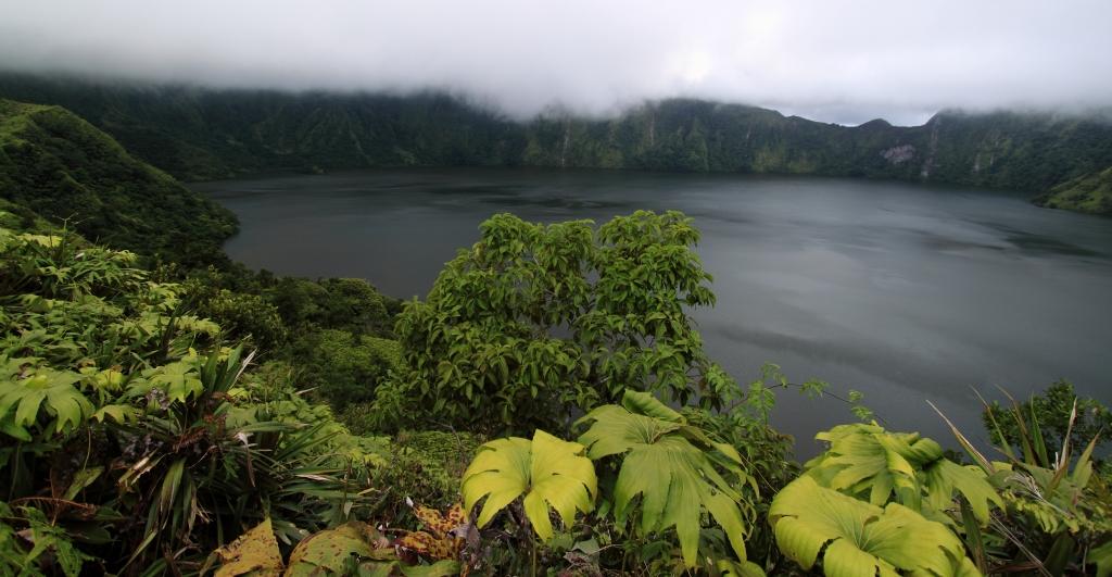
The crater lake of Billy Mitchell. Source https://harrygreenwell.wordpress.com
It is a funny name for a volcano. Traditionally, it is said to be named during World War II after the World War I US air force general of that name. But I have not been able to find the origin of this. Maps from the 1940’s do not show the name or mountain: only Mount Bagana is listed. Mitchell was never in the south Pacific, and no battles were fought near this volcano. An (unlikely) alternative might be that it was originally named after (or even by) Major John Mitchell: he was the leader of the 18 April 1943 air raid over Bougainville which led to the death of Admiral Isoroku Yamamoto, commander of the Combined Fleet of the Imperial Japanese Navy; and afterwards ‘Billy’ was added by the confused cartographers. It is just an idea. More plausible, perhaps, is that the name came from the B-25 Mitchell plane, a bomber used extensively at Bougainville in WW II and which in 1942 had been named after Billy Mitchell. There are stories about an intact American WW II plane on the northeast side of the mountain.
The name was originally given to the lake, and only later was transferred to the mountain. As there is a local name for the lake (Eruovi), this probably should be given precedence! For now, we have a volcano named after a lake which is named after a bomber which is named after an air force general. A lineage like this raises expectations.
Regardless of the name, at first sight the mountain itself does not look very impressive. The most obvious feature is the pictoresque but inaccessible 2-km wide crater lake, surrounded by steep crater walls. The lake is at 1 km height; the crater wall is up to 1500 meter high. Surrounding the mountain are thick deposits of pumice and pyroclastics, but little or no lava.
Two major eruptions have been attributed to Billy Mitchell. The first of these has been dated to 1113+-19 AD, and the second one to 1580+-19 AD. Both caused an extensive tephra blanket and were clearly explosive. The first event ejected some 7 km3 of tephra, and the second one produced 13 km3. The second eruption was a VEI 6 (just about) which disintegrated the top kilometer (my estimate) of the mountain. It caused widespread ignimbrite, and presumably is the eruption that left us the summit crater. The tephra of the first eruption is found across most of the northern half of Bougainville, to a depth of 10 to 60 cm. Tephra from the second eruption is found over a smaller area in the centre, to a depth of 40 cm. However, this eruption also caused a pyroclastic flow which covered 300 km2, stretching from Billy Mitchell east to the coast 20 km away. When Bougainville was first explored, the Pacific coast around Cape Mabiri was largely uninhabited. It has been suggested that this was because of this eruption.
One should be a bit cautious with the accuracy of the given dates: these were derived from carbon dating but the details are not available on-line. It would normally come from wood buried or incinerated by the volcano, and it is the age of the wood rather than the tephra (which cannot be carbon dated). Thus, the eruption may be a bit younger than assumed. Also, the dates are uncorrected, i.e. the required correction from a C14 date to a calendar date has not yet been applied. This could make the eruption a bit older. So in spite of the narrow range of dates that is normally given, the real uncertainty is much larger. The main eruption may have happened at any time between 1480 and 1640. The many web sites which attribute a specific climate event to this eruption should be taken with some scepticism.
Since the 1580 (presumed) explosion, Billy Mitchell has not erupted. The volcano is considered dormant — some say extinct.
Bagana
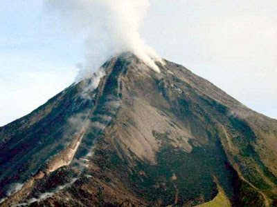
May 2004, lava flowing between levees 3 kilometers from the crater. volcano.oregonstate.edu
Bagana volcano is a 1700-meter tall cone, 6 kilometers south-southwest of Billy Mitchell. The cone is higher than its famous neighbour, but it is narrower. This is a mountainous rainforest region, not easy to get to and sparsely populated. There are some villages on the nearby coastal plain: around 8000 people live within 30 km of the volcano. They live with a hyperactive neighbour. Bagana almost always carries a smoke plume above its summit crater. The slopes are covered in lava flows and debris several kilometers from the peak. Often there is an active, creeping lava flow. Occasionally pyroclastic clouds come down the slopes (rarely traveling far). Bagana was discovered (by westerners, at least – presumably the local population was well aware of the volcano but that rarely counts) as an active volcano in the 1840’s, when it was seen erupting from ships.
Bagana erupts a slow moving, blocky lava, in flows which can last for months or even years. The lava forms long streams, surrounded by levees of solidified lava. The levees can grow very high, lifting the lava flow well above the surrounding slopes. In the 1880’s the local population said it has been erupting for 15 to 20 years already. This pattern of long-lasting eruptions has continued since. The eruptions are accompanied by explosive activity with ash and pyroclastic flows, especially at the beginning of a new episode, but these explosions are not large. Ash plumes rarely go over 2 km high. They are not without danger, though: in 1884 an explosion killed some people.

Figure adapted from Wadge et al. 2018 (see bottom of the post)
Bagana is unusually close to Billy Mitchell – volcanoes normally need some distance. But in spite of the close proximity, in some ways they are opposites: while Billy Mitchell is dead to the world, Bagana shows near continuous activity, and where Billy Mitchell ejected its dacite explosively, Bagana erupts effusively, expelling andesitic lava.
In between Bagana and Billy Mitchell lies a third volcano: Reini. It is a bit smaller than Bagana and is inactive. We’ll come back to this one later. North of Billy Mitchell is an old, eroded volcano, Numa Numa.
Activity at Bagana has been decreasing since 2005 but there still were several eruption episodes since. After 2016 activity has been minor, with a silent period from August 2019 to February 2020. However, even in the last weeks there have been VAAC alerts for ash clouds above Bagana. It is too early to call a close to its near-perpetual eruption.
In fact, Bagana is among the most frequently erupting volcanoes in the world. And it has another claim to fame: Bagana has the third highest average SO2 flux among persistently active volcanoes worldwide. During eruptions it emits around 3300 tons of SO2 per day. During quiet interludes, the SO2 flux drops but not by very much: it still emits 2600 tons per day even when it is not doing anything else. CO2 has not been measured but it is likely that Bagana’s production exceeds that of Ambrym. For a volcano without a lava lake, that is quite impressive.
The high SO2 flux during an eruption can be understood, but why does the emission remain high when there is no lava to degas? This implies that the surface activity is just the tip of the iceberg. There is a large, shallow magma reservoir that can effectively degas: it acts as an open system. The size of this reservoir is estimated at 2 km3.

Sentinel true colour image, 13 March 2020. Dark green is old rain forest, light green is recently vegetated lava flows.
The family silicic
Bagana is part of a family of silicic volcanoes. The family resemblance involves viscous, cool lava with large crystals, long-lasting (months to years) cycles of lava flows and dome building, with the latter leading to explosions, and high outgassing even when the volcano is not erupting. The dome building happens because eruption rates are relatively low (0.3 – 3 m3/s) and the lava is mushy. The lava ranges from basaltic andesite (as in Bagana) to dacite (as in Billy Mitchell, although this is not known to be a family member). (Not rhyolite which tends to be crystal-poor.) They are invariably subduction volcanoes. The activity can be persistent with the majority of time spend in eruptions, or episodic with long periods of quiescence between eruptions. Examples of this volcanic family are Merapi, Santiaguito, Unzen, Redoubt, Augustine and Shiveluch. Bagana shares these family traits, although its explosions are smaller than most. This may be because its magma system is unusually open.
But the explosions should not be underestimated. These volcanoes can build steep domes with the risk of flank collapse. If the conduit gets blocked, this could set the stage for a larger explosion. It would also increase the chance of a flank eruption, best avoided in a steep cone. St Helens is a warning of the potential consequences. Bagana is a well-behaved member of a crime-ridden family, but that does not mean it is trustworthy. At the moment it has a strong, on-going program of cone building which keeps it stable. This may however turn out to be a pyramid scheme.
Building Bagana
Bagana is a fairly inaccessible volcano, and reports on its activity have been sparse, especially during the civil war. The reports we have suggests that it is erupting most of the time. The flows come from the summit crater. Often, a small dome will build there, grow to some 40 meters above the crater, and explode. Lava rises and overflows the crater, in some direction. After months the activity becomes less and the cycle resumes. This process can continue for many years, before a brief period of quiescence and a new cycle where the lava will move into another direction.

Age of the top lava flow around Bagana. The ovals indicate where pre-1945 lava remains uncovered. Figure adapted from Wadge et al.
Mapping from the air began in 1943, when Bougainville became a WW II battle field. The earliest photos from the war are nowadays used to map where the new flows have occurred. Satellite and airplane images show that cloud cover is very common. This volcano can hide itself very well. Radar has perhaps been the most useful tool to map the mountain. The images have shown how active Bagana really is. Between 1945 and 2017, 70% of images show on-going activity and lava flows. Only 15% of the flank area mapped in 1943 still retains the surface from that times: a staggering 85% of the surface has been covered with lava flows since. Build your house here and destruction by lava is not a risk: it is a certainty.
So how much lava was extruded during this period? The area that is covered is impressive, but if the layer is thin, the net volume could still be quite small. But Bagana doesn’t do things by half. The viscous, slow moving lava is thick. By comparing detailed, drawn maps from 1945 with the most recent satellite images, it was possible to measure how thick each of these lava flows were. The comparison is not perfect: the old maps lacked precision in thickly vegetated slopes. But in many places good data was obtained. The typical thickness of the lava deposited since 1945 on the slopes is 140 meters! In some places it may be as much as 300 meters. That house is now a long way down.

Change in elevation between 1945 and 2014. Negative numbers most likely are caused by uncertainties on the old map related to densely vegetated, steep slopes. The largest increases correspond to the longest-duration lava flows. Figure adapted from Wadge et al.
This is certainly a very productive mountain! There is a bit lopsidedness evident, with the flows to the southwestern side longer than those to the north. This difference is real, and is caused by the environment. Bagana established itself on the slope from the Billy Mitchell massif towards the coastal plain. The flows directed down the slope are longer. On the other side, the mountain sits against Billy Mitchell and the flows have limited room. The younger lava flow are bare, but flows older than 50 years have greened up as vegetation returned.
Can we put numbers on the productivity? It requires measuring the volume of each flow, with approximate dates for the flows, and adding them together over certain time periods. The result is a remarkably uniform rate of about 1 m3/s. It varies from week to week, but the average has been around this value for the past 70 years. Over those 70 years, around 2.3 km3 has been added to the mountain. To put it another way: this one volcano erupts about as much lava on average as all of Iceland.
And it is not only the volume that is growing. The height is changing too. In 1945, the height was reported at 1742 m. In 1967 a similar number, 1746 m, was reported. But in 2000, it had grown to 1867 m, and by 2014 it was 1897 m. A growth rate of 200 meter per century may only be half that of Anak Krakatau, but Bagana has a larger volume and requires more lava per meter of growth.
In spite of this growth spurt, Bagana is not massive. The total volume of the mountain is not perfectly known, because we don’t quite know the shape of the bedrock underneath. Assuming that it follows the same slope as nearby, and that there may be a bowl underneath Bagana (caused by the weight of the mountain), the total volume may be as large as 10 km3. However, it could also be as small as 5 km3. Either way, a significant part of the mountain dates from the past 70 years. When the mountain was ‘discovered’, it was considerably smaller than it is now.
And that suggests that Bagana is a young volcano. Very young. A rough number, assuming the larger number for its volume, comes out at 300 years. Early eruption rates may have been smaller, in which case it could be a bit older, but not by very much. That of course it has in common with Anak Krakatau, which has only been above water for 90 years. These are child volcanoes. Wild children.
Is Bagana the youngest volcano on Earth? That depends on how you define it. Anak Krakatau is younger but it is really a rebirth. Several recent eruptions have build new volcanoes, such as Paricutin, but these are monogenetic volcanoes with single eruptions: they will never erupt again. Should they count? If not, than perhaps Bagana is indeed our youngest volcano. But I expect it is not alone.
Parent and child

The Billy Mitchell volcano, with Bagana (right) and Reini (left) in the background. https://volcano.si.edu/volcano.cfm?vn=255020
The age shows that Bagana began to grow just after Billy Mitchell had its larger explosion around 1580. Field work confirms this: the lava flows from Bagana always lie above the Billy Mitchell tephra, meaning that these lava flows are younger.
No indication for any volcanic activity at Billy Mitchell remains: there are no fumaroles, no gas emissions, no strange pH in the lake, no warm water. The conduit was well and truly blocked by the caldera collapse. But soon after the explosion and cessation, a new volcano started building 6 kilometers away. Was this Billy Mitchell’s magma using a new outlet?
If so, the magma supply rates should be comparable between Bagana and Billy Mitchell. Billy Mitchell ejected 13 km3, some 540 years after its previous eruption. Taking this number for the ejecta, converting it to DRE, and assuming it came from magma collected since the previous eruption, this gives us a magma input rate of 0.5 m3/s. This is within a factor of two of the current rate of Bagana. It is therefore conceivable that the two share the same magma source, which now has an open conduit towards Bagana.
There is a small twist here because Bagana erupts a different type of magma than Billy Mitchell did: basaltic andesite rather then dacite. The Billy Mitchell magma that exploded had been going stale for a while. The stale magma chamber must have received its magma form a deeper reservoir. When the conduit blocked and subsequently the upper magma chamber self-destructed, the deeper reservoir may may have grown a lateral dike. The south to southwesterly direction is towards the coastal plain. Gravity was strongly in favour of this way out, and it seems plausible that this is how Bagana was started.
In that case, as long as Bagana remains active, Billy Mitchell will remain extinct. Bagana could be the saviour of Bougainville!
There is more. In between the two volcanoes is a third one, poorly studied. This is Reini. It is inactive and there is no indication it has erupted after the Billy Mitchell eruption: the Billy Mitchell tephra is found all over the mountain and is not covered by any later deposits. The suggestion has been made that Reini is the older sibling of Bagana, and formed in a similar way. Perhaps it developed after the first Billy Mitchell eruption around 1100 AD, or perhaps it is older. But in either case, its activity didn’t last.
Reini holds a warning. It looks like Bagana, with one clear difference (apart from the eroded appearance): it misses its peak. The tip of the mountain has been lost. There is no evidence regarding how this happened, but perhaps it went the way of Billy Mitchell: eventually the summit blew up. If Bagana is like Reini, it may become more explosive than we would like.
Bagana came from a family of volcanoes, with Billy Mitchell as parent, Reini as older sibling, and perhaps Numa Numa as grand parent. It is a beautiful example of volcanic relations.
Santiaguito in Guatemala may have a very similar history to Bagana. It is located near Santa Maria, and it began its eruptive cycles after the 1902 explosion at Santa Maria. Perhaps if we return in 300 years, Santiaguito will look a bit like Bagana.
The crystal ball
Bagana is among the youngest volcanoes on Earth. 400 years ago, it didn’t exist. It is the offspring of a famous parent: Billy Mitchell. But it is not a copy of Billy Mitchell and it is making its own path. The lava is different and the eruption style is very different. As the 3rd most eruptive volcano on Earth (by gas emissions), Bagana deserves to be judged by its achievements, not our expectations.
Chances are that it won’t live long. Eventually, the magma supply may cease, Bagana will fade and Billy Mitchell will regain its vigour. But so far, Bagana is doing very well. And who knows, perhaps the parent will never recover, and Bagana will become the new head of the family. Perhaps history will repeat itself – with Bagana becoming ever more similar to the parent. A Billy Mitchell Jr.
With a volcano like this, it is worth our time to wait and see.
Albert, May 2020
This post is mainly based on the following article:
Persistent growth of a young andesite lava cone: Bagana volcano, Papua New Guinea: G. Wadge, B.T. McCormick Kilbride, M. Edmonds, R.W. Johnson. Journal of Volcanology and Geothermal Research, vol. 356, pages 304–315 (2018). (Not open access, I believe)
It also used two other papers by the same team
Multi-year Satellite Observations of Sulfur Dioxide Gas Emissions and Lava Extrusion at Bagana Volcano, Papua New Guinea: B.T. McCormick Kilbride, K. Mulina, G. Wadge, R.W. Johnson, I. Itikarai, M. Edmond. Frontiers in Earth Science, vol. 7, page 9 (2019). https://www.frontiersin.org/articles/10.3389/feart.2019.00009/full
and
Similarities and differences in the historical records of lava dome-building volcanoes: Implications for understanding magmatic processes and eruption forecasting: T. Sheldrake, R. Sparks, K. Cashman, G. Wadge, W. Aspinall, (2016). Earth Sci. Rev. 160, 240–263.
A description of Bagana’s historical activity can be found in
https://volcanohotspot.wordpress.com/2016/08/03/bagana-bougainville-island-p-n-g/
And this is a description of what traveling towards Billy Mitchell is like. Not for the faint-hearted.
https://www.travelinspired.co.nz/travel-articles/lake-eruovi-billy-mitchell-bougainville/
Who put a volcano in my rain forest?


That first paragraph is probably the most beautiful technical writing I have ever read…
A most excellent read!
I read somewhere that the Ontong Java plateau is the largest known submarine flood basalt (can hear Jesper galloping in this direction already)…Probably I read it on wikipedia which is of variable accuracy.
It is the largest one known. Ocean floors lasts for some 200 million years, so any similar plateau that is older would probably already be subducted. So we don’t have too much to compare with. It is probably the largest submarine one in the past 200 million years. Beyond that, we can’t say.
: D Indeed it was immense
100 million cubic kilometers in just a few short 100 s thousand years
A short lived Cretaceous Superplume event
Really fast underwater flows, can flow just like those on land “called massive submarine sheet flows”
Lava can really flow like rivers underwater if eruptive rates are high enough.
Ontong Java Plateau are alll massive sheet flows, very thick too.
These flowed like true raging rivers over the seafloor, feed by high erutptive rates.
No pillow lava there… not at all
Eruptions occured from submarine fissures that coud have been almost 500 kilometers long
or longer than that. maybe over 800 km.
The lava flowed for thousands of kilometers over the seafloor.
Most of its fissure events was likley much smaller than that.
But big flows on Ontong Java Plateau far exceeds the tiny columbia river basalts.
That ammount of volume in a short geological time, indicates it was many very large fast flows,
rather than a slower constant ooze.
Imagine all the gas pollution and discoloured water, under souch a event.
The sea over a wast arera became dead and toxic and discoloured.
The climate effects from OJP is not well researched.
But I knows that cretaecous had very high CO2 levels and greenhouse climate.
The worlds largest atoll, Ontong Java Atoll can be found there
But that was from a younger volcano, still very large.
But the sea is “shallow” over this LIP plateau compared to Hawaiis abyss.
So the extinct Ontong Java Atoll volcano probaly haves a fairly small volume.
If it was a constant event all through it
We are talking about 40 km3 of lava erupted every year
Thats still two Lakis every year for 100 s of thousands of years
As long as the mantle plume head was hot and active.
melt rates where enromous
But Im soure that OJP had many flows with volumes of tens of thousands of km3
and erupted much much faster than laki
But the climate data during that time?
Creatceous had a very warm climate during the OJP times¨
But I knows thats seafloor spreading was isnanely fast back then
Perhaps Createceous thermal maximum comes from that
Lots of CO2 as high as 1900 PPM
But OJP should have left its mark in the atmopshere
But maybe the ocean absorbed some of the CO2 ?
Europe during the OJP times was a seriers of scattered Islands in a warm tropical chalk sea. Sealevels where extermely high perhaps 250 meters higher than today
Albert what effects did OJP have on the climate back then?
Ontong Java plateaus effects on the climate depends how fast it was
But even at slowest side it was … really nasty.. and really scary
40 to 50 holohurauns every year is nothing to laugh about if it happens today.
But Im soure OJP had much much larger events than a constant Thjorsaharun
If this study is correct, it used to be much, Much, MUCH bigger…
https://phys.org/news/2020-05-world-largest-lava-lamp-nz.html
which references *FREE* journal article…
https://advances.sciencemag.org/content/6/22/eaba7118
Remarkably, it does not seem to have spawned a ‘triple junction’, but has been fragmented by existing tectonics…
@Nik Thanks for the fascinating links!
Did this plume leave behind a hot spot like the Deccan Traps did?
Kendog
OJP Superplume event did not form a long lived mantle plume
Or If it did
The hotspot track may be competely subducted now
Well written, thank you!
Yes, thanks for your interesting and entertaining description of those volcanoes. I was especially interested in Billy Mitchell.
Bagana is impressive for being a andesitic / dacitic volcano
Most volcanoes that are that peroductive are basaltic.
Bagna constantly erupts stale evolved magmas.. without becomming more mafic
Probaly is a very large resovair of evolved magma feeding it
And in other news, the best comet since a century is heading towards us – and we will not be able to see it. Comet C/2017 K2 is the most active comet we have seen beyond Saturn. It is on a 3 million year orbit but may have been perturbed to a hyperbolic orbit, never to return. Its closest approach to the sun is around christmas 2022, but is beyond the orbit of Mars which will limit the brightness. It is also in the far south, visible only from the southern hemisphere, and more or less in the direction of the sun which in mid-summer (southern hemisphere) makes it unobservable. NASA compares it to Hale-Bopp which was large and bright but unimpressive (we have seen much better comets since).
We have rockets which can reach the location of closest approach, but it would be for a fast flyby (we don’t have rockets that can match its orbital velocity and direction without gravity assists). Launch would have to be in early 2022. SpaceX, perhaps?
Job for a passel of cube-sats, like that Mars mission’s outriders ??
WIshing good luck to SpaceX and NASA with Crew Dragon.
There latest Starship prototype SN4 exploded spectacularly on the test stand yesterday, shortly after a test fire. Most observers did not expect them to start test fires again on SN4 until after the ISS flight – but this is Elon Musk after all…
Best camera views and commentary by Scott Manley
Business as usual 😎
Thank you Albert! A fascinating article. You had me on Google Maps looking for the aeroplane…
What will Earth look like when the next supercontinent forms? Here are four options. We may have a vote
https://theconversation.com/what-planet-earth-might-look-like-when-the-next-supercontinent-forms-four-scenarios-107454
It is assumed that the Intelligence will have no effect on plate tectonics…
(I read this remark in the preamble of a book on the ultimate fate of the Universe 35 years ago…)
Since it is suspected that the Indo-Australian plate is breaking up, a subduction in the Indian Ocean should be taken into account.
For what it’s worth, “my semi-uneducated guess” vote goes to #1, Novopangea, with #2, Pangea Ultima, a close second.
Try a vote!
https://www.surveymonkey.co.uk/r/8S7W33J
Regarding the future of the world, Amasia is currently in the lead. That is the one where all continents apart from Antarctica converge on the north pole. It is one way to fix global warming.. If you want your future to be different, you can still vote!
I’d think that 200-250 million years from now, the sun will be a little brighter than today, as its luminosity is steadily increasing as it ages along the main sequence – even long before it turns into a red giant. I’ve read somewhere that in 500 million years, the Sun will be about 10% brighter than today. This would be enough turn Earth into another Venus.
So in about 250 My, Earth could well manage to get warmer with Sol’s increased brightness, even with lower amounts of atmospheric CO2 due to the amount of C4 plant life having mostly, if not entirely, replaced C3 plant life.
Indeed Mike K
Earth will become an empty eeire desert 700 million years from now. The lands are empty almost, and life moves back into the ocean. The lowering of CO2 by weathering will choke most complex life to death.
600 million years from now,
there are No mammals, No birds, No reptiles
They are all extinct, but there is still life in the empty continents clings on in the ever hotter climate.
How long the oceans will last, I dont know
But we have the solution right here at VC. https://www.volcanocafe.org/saving-the-earth-with-asteroids/
I’d go with Novopangea, but I do expect that there will be more subduction around the Atlantic rim. I just don’t expect that will reverse the trend of the Atlantic growing and the Pacific shrinking. The reason has to do with the spreading centers. The Atlantic’s is intact, while the Pacific’s has mostly subducted. There’s nothing left in the north Pacific and the East Pacific Rise is gradually disappearing underneath the Americas. If that trend continues, the Pacific seafloor will increasingly be dominated by subduction. On the other hand, I expect the MAR to speed up, becoming more EPR-like in its profile and spreading rate, because development of subduction along the Atlantic rim will increase the pull on the plates to either side of the MAR. If anything, the Atlantic’s widening will accelerate because it will have to make up for the shrinking Pacific.
Awesome article, Albert. Thanks.
Any idea where the source of the tremor today on the big island? how do they locate something like this?

From deep below Pahala (from where most Hawaiian tremor comes), HVO located it:
M 2.4 – 8km SSW of Pahala, Hawaii – 48.26 km deep – 11:02:41 UTC
M 2.6 – 10km SSE of Pahala, Hawaii – 40.82 km deep – 11:05:42 UTC
HVO locates the spikes in the Pahala tremor as separate earthquakes, one scientific paper calls them tremor quakes. However since anything below M 1.8 in the Pahala area doesn’t make it into the USGS catalogue, for whatever reason that I ignore, therefore do not show in earthquake maps. It still useful however to see if any location matches in time with the tremor because the strongest events will usually have some tremor quakes shown.
This particular tremor seems quite strong, going from memory it might be the largest Pahala tremor since late summer 2019.
The 2020-05-30 15:33:16 3.2 -2 at Mona Loa shook the tilt meters.
Today’s quakes seem very shallow. Assuming the top of ML is 4.2km, and negative depths are distances above sea level, then I’ve added the height of ML to the depth of the quakes to get the depth of quake from the top. It’s in red.

Holy cow…
50 kilometers down?
The crust in Pahala is extremely hot.. really extreme heat
Souch hot soft flexible rocks should not quake at all.
The entire deeper litosphere under
Big Island and South Maui maybe molten
Hawaii is alot of heat loss and soft crust over the plume
Sort of.
And on the other side of the world another swarm of earthquakes underneath Grindavik with over 100 (small) quakes already:
Beautifully written, Albert. Once again VolcanoCafe has broadened my knowledge! I admit absolute ignorance of volcanism on Bougainville, but no longer. And what a fascinating little family of peaks that they are.
A great many thanks. Cheers.
Another nice video from OPB, talking about Cascade volcanoes and volcanology methods.
Informative video, thanks. The bulge at Sisters has stopped growing, hasn’t it?
I have contacted the IGEPN! I have gotten incredible information! (cricket noises)
Comprehensive ain’t it?
To keep myself from looking disrespectful I neglected to bring up my caldera concerns and only brought the earthquake count discrepancy. This is the second time I have contact them and while I could still get an answer. My hope is not up in the slightest
3.3 just happened on Mauna Loa.
2020-06-02 16:33:13 3.3 -1.4
M3+ quake on Mauna Loa. Quite a jump in the nearest tilt meter, and a very small shift in the one on the summit.
# Time to release the Siberian Traps 2.0 from there
Eeeek I wants aramageddon constantly
Africa will be fun once the craton… cannot hold it anymore
Ominous boulge growing in east africa.
One day it will be Laki on a continent sized scale there : )
This study says that the Deccan traps played no role in the K/PG extinction…
https://www.deccanherald.com/science-and-environment/meteorite-impact-not-indias-deccan-traps-volcanoes-led-to-dinosaurs-extinction-study-795415.html
Thoughts?
This discussion will go on for some time. A combination of the two still remains the most likely, with the impact causing the sudden disappearance and the eruption stressing the environment beforehand.
M5.5 just now in Searles Valley on the extreme SE end of the Ridgecrest aftershock zone….which may be indicating crustal failure is expanding, as compared to most of the other aftershocks that’s being filling in the primary fracture zone. Pretty unusual for an aftershock of this size being it’s been 11 months than the main shock last July?
Landslide near Alta, Norway yesterday. No casualties, one dog rescued.
https://youtu.be/6QcBSbQo4XA
Quick Clay strikes again.
Thanks Geo, interesting read.
The result of the survey on the future of the world: Novopangea came out just ahead, with Amasia second. Novopangea is where everything keeps moving as it does now with America and Asia merging, and Amasia is where everything converges on the north pole. Futures where the Atlantic ocean develops subduction zones and closes are less popular. So, Novopangea it is.
And for your enjoyment, here are the results of the Cambrian elections on the future of the continents. This is how we got to where we are.
Nice!
That poor cellist…. Rockelbel’s Canon. Ugh.
Pachelbel.. not Rockelbel..
New aftershocks following yesterday’s surprise M5.5 aftershock of the 2019 Ridgecrest quake continue at a very high rate (well over 100 spread out over about 5 miles) …very unusual for an aftershock to produce so many aftershocks on it’s own. IMHO, it looks like “virgin” crust was broken, since an aftershock closer to the 2019 main shock(s) should not have that much un-released stress left. Also note, that a swarm near Coso Junction along I-95 just east of South Halwee Reservoir with a main shock of M4.2 seems to have been triggered, despite being ~ 60 miles away. Perhaps the nearly “pure” right-lateral strike of the M5.5 was unusually efficient at transferring stress over such a large distance? but this is purely speculation on my part. Coso Junction is a known hot spot with a high degree of seismicity, but how/if stress transfer from a mere M5.5 quake made it this far NW is certainly curious? More likely, the Coso Junction swarm is an induced/indirect event and not directly related to stress transfer coming from the M5.5 shock…but only time will tell which trigger mechanism is/was involved (if any…it could be just a coincidence).
Regardless, it’s easy to connect the dots between this new Ridgecrest activity and the Coso Junction mini-swarm which forms a nearly perfect straight line striking SE-NW.
It’s tempting to believe that a major quake may break the entire 60 mile length, as there have been several major quakes within the last 1-2 centuries that have relieved a lot of stress in the immediate area, so chances of any continuous line of slip are virtually nil (but not zero).
https://earthquake.usgs.gov/earthquakes/map/#%7B%22autoUpdate%22%3A%5B%5D%2C%22basemap%22%3A%22terrain%22%2C%22feed%22%3A%221day_all%22%2C%22listFormat%22%3A%22default%22%2C%22mapposition%22%3A%5B%5B35.38457160381764%2C-118.63998413085938%5D%2C%5B36.359374956015856%2C-116.88217163085938%5D%5D%2C%22overlays%22%3A%5B%22plates%22%2C%22faults%22%5D%2C%22restrictListToMap%22%3A%5B%22restrictListToMap%22%5D%2C%22search%22%3A%7B%22id%22%3A%22ci39462536%22%2C%22isSearch%22%3Atrue%2C%22name%22%3A%22Search%20Results%22%2C%22params%22%3A%7B%22endtime%22%3A%222020-06-25T01%3A32%3A11.140Z%22%2C%22latitude%22%3A35.6148333%2C%22longitude%22%3A-117.4281667%2C%22maxradiuskm%22%3A250%2C%22minmagnitude%22%3A2%2C%22starttime%22%3A%222020-05-14T01%3A32%3A11.140Z%22%7D%7D%2C%22sort%22%3A%22newest%22%2C%22timezone%22%3A%22utc%22%2C%22viewModes%22%3A%5B%22list%22%2C%22settings%22%2C%22map%22%5D%2C%22event%22%3Anull%7D
And here’s the seismicity (hi-res) for the last 7 days near Ridgecrest. The SE-NW strike of the activity between Ridgecrest and Coso Junction is clearly evident. Note, that after further review the linear distance between the Coso Junction swarm and the new M5.5 Searles Valley shock is ~ 50 miles, not 60 miles as I previously posted.
https://earthquake.usgs.gov/earthquakes/map/#%7B%22autoUpdate%22%3A%5B%22autoUpdate%22%5D%2C%22basemap%22%3A%22street%22%2C%22feed%22%3A%227day_all%22%2C%22listFormat%22%3A%22default%22%2C%22mapposition%22%3A%5B%5B35.38457160381764%2C-118.69903564453124%5D%2C%5B36.359374956015856%2C-116.94122314453125%5D%5D%2C%22overlays%22%3A%5B%22plates%22%2C%22faults%22%5D%2C%22restrictListToMap%22%3A%5B%22restrictListToMap%22%5D%2C%22search%22%3Anull%2C%22sort%22%3A%22newest%22%2C%22timezone%22%3A%22utc%22%2C%22viewModes%22%3A%5B%22list%22%2C%22map%22%2C%22settings%22%5D%2C%22event%22%3Anull%7D
How far away from the Coso Volcanic Field are these quakes?
The CVF is between Ridgecrest and Haiwee Reservoir, the sites of the two current swarms. This region is seismically very active, with numerous significant tectonic events in recent times, with the latest being in 1992. However, despite it’s name, there have been zero volcanic events in the Halocene (per the GVP).
I’m almost disappointed. I love it when a small isolated volcanic region that has been silent for a long time becomes active.
Well, Long Valley is nearby? Maybe there’s hope?
From the eminent Dr. Lucy Jones, guru of Southern California seismology:
“The M4.2 with its own aftershocks near Haiwee is also a Ridgecrest aftershock. That is the northern end of the aftershock zone. Why both ends go in the same night is a bit of a mystery. Direct triggering is out because they are too far apart”
Interesting. The timeline shows the Haiwee/Coso Junction M4.2 shock was preceded by several days of light shocks in the immediate area that ranged from mid2’s to mid’3’s. Then, the Searles quake hit, which was then followed almost immediately by the M4.2 Haiwee jolt 50 miles away. As Dr. Jones said (and me), this is way too far a distance for direct triggering between events this small…but the close timing between the two events (less than an hour) is either a major coincidence, or there’s something going on with the way these two zones are coupling that we don’t fully understand.
The direction of slip may give a clue. If this is perpendicular to the fault (i.e. the slip was with a transverse fault) you can transfer stress much more easily over a long distance. https://www.wired.com/2016/12/pull-car-ditch-super-strength-physics/
Thanks Albert for this great nugget! I have used this principle many times when tying down a tarp or heavy object on my pickup truck, where I tie a rope to the middle of a longer rope and draw it to the side to tighten it…but I never gave a second thought about the physics.
As for applicability to stress transfer (in this case), the issue may be a bit more complicated inasmuch as stress would have to get transferred through the CVF, which is very hot just below the surface….and similar in depth to the hypocenter. It therefore seems likely that the crust at depth is more ductile than the more brittle surface layer, so the “rope” (crust) in your physics lesson would act more like a rubber band than a relatively inflexible connection between two points?
Thank you again for any further comments! Always look forward to an opportunity to learn a thing or three.
If there are earthquakes it can’t be too ductile. What I had in mind that at one end of the fault, you get a transverse slip. That is the point where you pull the rope. At the other end, you get force along the fault, sufficient to make it fail. It was only an idea.
New post is up. The secret mountains of Siberia.
https://www.volcanocafe.org/terra-incognito-the-verkhoyansk-mountains/