
Eldfell, the fire mountain, overflowing Vestmannaeyjar town in 1973. Photo/Valdís Óskarsdóttir/Reykjavik Museum of Photography
The facts of Eldgja are well established. We know approximately when it happened, where it happened, how much lava, tephra and sulphate was ejected. We have found the tephra in Greenland. We think we know the human impact over much of the northern world, arising from three years of winter. But on other aspects, our understanding is on thinner ice. We don’t know anything about the human impact in Iceland itself. We don’t know what caused the fire, or why it erupted as much as it did (and no more). We don’t know which volcanoes can feed such a fire. And we don’t know when the next one will be.
Let’s first clear up a separate confusion. If we accept shifting the Neem and NGRIP ice cores by 5 years, there is no longer any sulphate peak at 934 AD. The evidence for a long-lasting event came from the need to reconcile the 934 and 939 peaks, seen in different ice cores. Now there is only one peak, lasting 2-3 years, securely linked to Eldgja by the tephra in it. But this is not the full story. The NGRIP core still shows a second, weaker sulphate peak, some years after the main one. In the original dates, this second one approximately lined up with the later peak of the GISP2 core. In the new dates, it doesn’t. So by solving the Eldgja problem, we have created a new, later eruption. What was this?

Sulphur in Greenland ice cores. Data from Sigl et al. 2015. Plotted is the total sulphur, in parts per billion, excluding that coming from sea salt. The assigned dates assume the revised time line. For the old time line, subtract 5 years.
The VEI7 that wasn’t
The two sulphate peaks in the ice core record are separated by about 7 years. In the revised chronology, the second, weaker sulphate peak occurs around 945 AD. Could this have been a final flourish of Eldgja? It turns out that this is not the case. The ash from the first peak has been securely identified with Eldgja. But the ash in the second peak, found both in the NEEM and NGRIP cores, is different. In particular, it has a higher iron content relative to calcium than found in Iceland. A paper by Sun et al. in 2013 showed that the composition of these fragments was a close match to Changbaishan volcano (also known as Baitoushan or Paektu), on the border between North Korea and China.
Changbaishan has a crater lake called ‘Tianchi’. The name means ‘heavenly lake’, and it is the source of three different rivers. But its formation was far from heavenly, unless from a very upset heavenly creature. The lake formed in a massive eruption, a VEI 7, about a thousand year ago. (The North Korean nuclear test explosions are done very close to this inflating volcano. Military stupidity knows no end.) The VEI 7 classification makes it one of the largest events of the millennium – I have seen it listed as among the 10 worst eruptions of recent history. It is sometimes called the millennium eruption, not because of its size or age, but because some estimates have dated it to 1000 AD.
Amazingly, for such a major eruption in a highly developed and literate region, there are no written records of it. In this, it is just like Eldgja. There are indirect mentions. In Kyoto, an explosion (thunders like a drum) was heard in February 947, and white ash fell in Nara, Japan on 3 Nov 946. In Korea’s capital Kaesong, drum-like thunder was heard in 946. The 14C dating has not given a unambiguous date, but the best determinations also put the eruption around 946, within a few years. The identification of its ash from Greenland now confirms this date, and the second sulphate peak can be identified not with Iceland, but with Changbaishan, a continent away.

Changbai mountain, after the milliennium eruption
It is a funny coincidence that there were two major eruptions from entirely different volcanoes, separated by about the same amount of time as the uncertainty in the dating of the ice cores. Science can be difficult. (For some reason, major eruptions more often happen 7 years apart: volcanoes do a 7-year itch. This happened in the double event of 540, the double event of 1453/1495, and the two big bangs of 1809 and 1815. Coincidence is like the lottery: funny things happen.)
But if Changbaishan occurred in 946/947, why was there no volcanic winter after this? A VEI 7 is massive and all known VEI-7 eruptions have had major effects. It turns out this eruption may have suffered from a numerical error. A VEI 7 eruption is defined as more than 100km3 ejecta. Changbaishan indeed erupted 100-120 km3 in tephra, but the DRE value is much less, 30 to 48 km3 – making it a ‘run of the mill’ VEI 6. The relatively small caldera, 5 km wide, agrees with this assessment. It was big, but not world shattering. That “Tianchi” was a VEI 7 appears volcanological fiction.
The sulphate deposition in Greenland from Changbaishan’s millennium eruption was much less than that of Tambora, and even less than Krakatoa. Those two eruptions were tropical and a northern eruption such as Changbaishan should deposit more sulphate in Greenland, not less. Oppenheimer lists it as ‘only’ M6.8 (about a third smaller than the smallest VEI-7), but even that may be a high estimate. It was a significant eruption: downwind in Japan the ash layer was 10 cm thick. But Changbaishan was too small for major climatic consequences.
This is no excuse for making it the only volcano in the world subject to experimental nuclear detonations!
Feeding the fire
After this Korean diversion, let’s get back to Iceland. There have been four major ‘fires’ in Iceland since the ice age, all four in the East Volcanic Zone. Two were in historic times: Laki and Eldgja. The third was around 8000 yr ago, the Holmsa fire, with a volume of at least 5 km3. Its lava is mostly buried making it hard to accurately measure the volume. Holmsa occurred on the same NE trend where Eldgja also erupted, but the exact source region has not been found and may have been covered by Eldgja lava. The fourth, and largest, was the Thorsja lava flow, 8600 yr ago, estimated at 22 km3. The Thorsja fissure is to the north of Eldgja.

The Thorsja lava flow. Source: Árni Hjartarson (wikimedia)
The fact that each of the fires here comes from a different rift shows that the EVZ is a wide, weak zone which can break in numerous places. It is pulled apart, breaks, stitches the break with solidifying magma (the ultimate poly filler), and breaks somewhere else. It doesn’t offer much resistance! Half of all lava erupted in Iceland since 900 has come from here. And this is in spite of the EVZ not having any major volcanoes itself. It is a conduit for volcanoes located elsewhere, and is being fed from its edges: Holmsa and Eldgja came from Katla, Laki came from Grimsvotn, and Thorsja came from Bardarbunga. Each of these three major volcanoes produced one (at least) massive fire in the EVZ. Iceland is truly a land of equal opportunities.
Why doesn’t the EVZ have a big volcano of its own? Perhaps it is too weak to hold down a big enough magma chamber. That it lacks a big magma chamber is shown by the topography: the area is much lower than the raised peaks of Mýrdalsjökull (Katla) and Vatnajökull (Bardarbunga/Grimsvotn). Hot magma has lower density than the surrounding rock, and therefore lifts up the land above it. Just by looking at the topography you can already get an idea where the magma chambers are. (This only works well for liquid rock: solid rock can be out of equilibrium. But it works well for magma.) Gravity reveals what’s hidden below, and it shows that although the EVZ may not be devoid of hot magma, it lacks huge reservoirs.
A matter of gravity
It is an interesting fact that each of these three main eruptions along this rift zone produced similar amounts of lava. Effusive eruptions are fed by a pressurised magma chamber. In the case of Holuhraun, the main force pushing magma to the distant exit was gravity: the exit point was a kilometer lower than the top of the mountain, and the weight of the mountain pushed it out. Could this be true for the three main fires as well?
Let’s estimate the pressure on the magma chambers from the weight of the mountain. The magma chambers are typically 10 by 10 km, with a surface area of 100 km2. The magma chamber carries the weight of the mountain above; the rift next door has no mountain on top of it and carries much less weight. The magma chamber is therefore over-pressurised with respect to the rift: if it can connect to the rift, the magma will flow towards it, just like the communicating vessels from school physics lessons. This is true even if the leak is much deeper than the rift.
The top of the mountain is about 1 km above the rift. The total volume which gives the excess weight is the surface area of the chamber, multiplied by this height, which becomes 100 km3. This is the most magma that can be pushed out by the mountain. In the case of Holuhraun, perhaps a quarter to a third of the magma coming out of Bardarbunga ended up on the surface: the rest was used to fill up the rift. If the same ratio holds for these very large fires, the most that they can erupt becomes about 30km3. The numbers make sense. Eldgja was not far off the largest fissure eruption Iceland can support.

Mýrdalsjökull ice-free topography: a view from the North East. Helgi Björnsson University of Iceland
Katla’s caldera is about 140 km2 large and 750 m deep. This gives a volume of 100 km3 (a bit overestimated), consistent with the numbers above. The bottom of the caldera is at about the same height as the Eldgja rift, perhaps not accidentally. Bardarbunga’s caldera covers 80 km2 in area and is 700 m deep: it has a volume of 56 km3. The bottom is at 1100 m, which is a bit higher than its fissure eruption but the caldera may have recovered a bit since its fire. Grimsvotn’s caldera is a bit smaller, at 50 km2. I have not found a value for its volume, but the smaller area would be consistent with the fact that Laki was a smaller eruption than Eldgja or Thorsja. The numbers hold up: it is conceivable that the Icelandic fires are gravity fed.
This implies that these three calderas may have formed in their respective fires. Grimsvotn’s caldera in particular would be very recent, and is the missing hole left from feeding Laki.
Caveats Two disclaimers are needed. First, the fires are not the only way Iceland can form calderas. Individual volcanoes can also have large explosive eruptions, which are pressure driven and can eject vast amounts. But in recent centuries, the major fires have been dominant and the current calderas would be due to the fires. Calderas can form suddenly, but can also disappear rapidly, within centuries, as the magma chamber refills.
The second disclaimer (speculation alert) is on the maximum eruption size. By keeping the rift narrow, it is possible to use less magma to fill the rift so that more is available to be erupted. That could double or triple the erupted volume, from the same amount of magma. But it wouldn’t be a fire: because of the narrower rift (or dyke) it would erupt at a lower eruption rate, effusive but without the flow volume needed to maintain the enormous fountains over an extended fissure. The lower eruption rate would tend to build a shield volcano, slower to grow but potentially reaching a large volume. The EVZ notably lacks shield volcanoes.
Katla’s state of the nation

Katla has a long history of eruptions. Over the past 8400 year, it has erupted 350-400 times, about four times per century. The large majority were explosive: only about 10 effusive eruptions have been identified, and 8 of these were minor. Eruption rates were high between 2000 and 4000 yr ago (when the two largest explosive Katla eruptions occurred), and between 7000 and 8000 yr ago. The modern rate is only half of the average: Katla has gone a bit quiet (this should not be overstated: it is a bit like a teenager with ADHD having a better day.) This better day may have started after Eldgja.
It is worth noting that Katla had a significant eruption around 920, 15-20 yr before Eldgja. There was no quiet period before the fire. Katla ‘fired’ without needing time for any extensive preparations. The eruption came from its normal supply of magma, without the ominous silence that other volcanoes use to signal danger ahead. It happily continues to erupt in its usual regular irregularity, and suddenly wipes out Iceland. It is as predictable as that North Korean – the one trying to detonate a volcano the nuclear way.
Katla’s eruptions invariably melt vast amounts of ice, which comes out as large floods. The jokulhlaups carry several times more sediment than the eruption ejects! Large ones occur twice a century but small ones, caused by geothermal melting, happen every year. Before Eldgja, the jokulhlaups emerged in various, unpredictable directions, but afterwards they have only appeared from the eastern glacier. Something has changed at Katla. The Eldgja rift may provide a channel for the melt water, breaching the caldera, and that still rules the floods.
The reduced eruption rate and the cavernous caldera suggests that Katla is still recovering from Eldgja. It is unlikely to put in an Eldgja repeat performance any time soon.
As I write this, Katla is responding by shaking its insides, clearly protesting against this assessment. Everything Katla does is pre-eruptive, because Katla erupts so often and by definition is always in an pre-eruption state. Even the summer snow melt is pre-eruptive activity. Even a butterfly settling down could set it off. It is the angry young man of volcano-world. If these are Katla’s quiet years, imagine what it was like in the times when it erupted twice as often. But the chance of the current shaking leading up to an Eldgja-II is somewhere between slim and zero. It isn’t yet ready.
Back to the future

Icelantis By Tjeerd Royaards
There are two remaining questions. Why, when the smaller Laki eruption was so devastating, do we not have historical records of the Eldgja disaster, and second, when will it re-occur?
The first question can only be answered with speculation. It is hard to believe that Eldgja would not have badly affected the Icelandic population. The region most affected, in the south, may have been thinly populated (although the Book of Settlement claims otherwise), or largely illiterate. Similar to Laki, agriculture in large areas of Iceland would have been hard hit and the population declined, although perhaps the food supply was more reliant on the sea than on produce from the land. Eldgja began just after the official end of the 60 year of settlement. Perhaps this period ended because Eldgja had made further immigration unattractive. The lack of written records could be directly due to the economic and human damage. But it really is an unanswered, and important question.
As to the future, we have been very unlucky to have two of the three major fires happen during the brief time Iceland has been occupied. It was bad karma. On average, they have happened only once every 3000 years. There is only a 3% chance of a Laki within the next century. No worries. Unless, that is, if the last 1200 year are the new normal.
Looking deeper, the three main source volcanoes for the EVZ may not yet be able to repeat their performance. The calderas are still too deep for gravity to act its full power. Of course an area offset from the existing caldera could act up, but eruptions do tend to come from the existing calderas, either directly (Grimsvotn) or indirectly by feeding a fissure (Bardarbunga). But there is one question mark. Because this area of Iceland does not have three major volcanoes, it has four. And the fourth is quietly biding her time.
Hekla is the one volcano in the region which could feed a major fire. Will it? Probably not. She may have a fiery temper, she does not have a fiery habit. But do be wary of the Lady.

Olaus Magnus Historia om de nordiska folken. 1555.
Eldgja: The End
The search for Eldgja has been a fascinating experience. So little is known, and what is there is scattered over the literature. Pulling it together revealed the holes in our understanding, and isn’t that what research is all about? But a better understanding is important. What Iceland did once it could do again. What Iceland did twice it will do again. Two of the six worst volcanic affairs over the past 1200 years have come from Iceland. To be prepared, we need to know what happened. The next step in the Eldgja saga should be to solve the dating problem: with a precise date we can look for its impacts around the northern hemisphere. And finally, archaeology of affected Viking sites would tell us how it changed their world. It could change ours.
Albert Zijlstra, September 2016
References
T. Thordarson G. Larsen: Volcanism in Iceland in historical time: Volcano types, eruption styles and eruptive history. Journal of Geodynamics 43 (2007) 118–152
Ash from Changbaishan Millennium eruption recorded in Greenland ice: Implications for determining the eruption’s timing and impact. Chunqing Sun et al. Geophysical Research Letters, 41(2), 694-701. http://pure.qub.ac.uk/portal/files/13968752/Sun_et_al._2014.pdf
M. G. L. Baillie and J. McAneney: Tree ring effects and ice core acidities clarify the volcanic record of the first millennium. Clim. Past, 11, 105–114, 2015. http://www.clim-past.net/11/105/2015/cp-11-105-2015.pdf
Michael Sigl et al. A new bipolar ice core record of volcanism from WAIS Divide and NEEM and implications for climate forcing of the last 2000 years. Journal of Geophysical Research: Atmospheres, 118, 1151–1169, 2013
Michael Sigl et al. Timing and climate forcing of volcanic eruptions for the past 2,500 years. Nature, 523,543–549 2015
Gregory Zielinski et al., Evidence of the Eldgjá (Iceland) eruption in the GISP2 Greenland ice core: relationship to eruption processes and climatic conditions in the tenth century. The Holocene, 5, pp 129-145 (1995) D. McCarthy & A. Been: An evaluation of astronomical observations on the Irish Annals. Vistas in Astronomy Vol. 41, No. 1, pp. 117-138, 1997
Magdalena Schmid et al. Tephra isochrons and chronologies of colonisation. Quaternary Geochronology (2016) T. Thordarson et al. New estimates of sulfur degassing and atmospheric mass-loading by the 934 AD Eldgjá eruption, Iceland. Journal of Volcanology and Geothermal Research, 108, 33–54 (2001).
T. Thordarson et al. New estimates of sulfur degassing and atmospheric mass-loading by the 934 AD Eldgjá eruption, Iceland. Journal of Volcanology and Geothermal Research, 108, 33–54 (2001).


Katla eruption simulation:
Is this a ash distribution simulation for aircraft – or is it estimated “tephra on ground”?
In case of a VEI 5 or VEI 6 eruption of Katla, Katla could also produce pyroclastic flows which could hit Heimaey and Surtsey. Pyroclastic flows easily travel over water, think about Krakatoa.
Probably not.
First of all Katla is not the type for pyroclastic flows.
You would truly have to dream dark dreams of an ignimbrite base surge to reach Heimaey, and then we are talking borderline VEI-7. Not even a medium sized VEI-7 would produce something that would reach Surtsey.
Krakatoa to the coast is just a short jump compared to the distances involved here.
Why isn’t Katla a type for pyroclastic flows? During an explosive Plinian eruption the eruption column can collapse, causing pyroclastic flows.
Thanks Albert for a great series and also for posting the 3-D of Katla under the ice.
I was looking for just this to explain why the river to the north is seeing an increase in conductivity. It is quite clear there is a perfect drainage channel that empties northward.
Such a marvellous series, a true epic of volcanology Albert! Thank you!
This has been an awesome triology, thanks.
One question, if the fires are a matter of gravity, what happens then when the caldera floor can’t sink any further? No more fires?
I interpret the Albert-model in a way that says that you are correct in that assumption.
The earthquake activity in Katla since 2011, red dots are 0.5m+, small green stars are 3m+ large green stars are 4m+
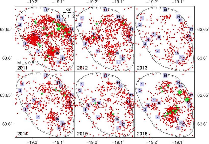
from IMO’s fb page https://www.facebook.com/Vedurstofan/
I take it that the numbers refer to those assigned to the major “Katlar”, “Ice cauldrons” by the IMO?
It is also interesting to note that the two areas of the greatest and most persistent activity do not correspond to the two points from which the three latest, major eruptions have sprung.
The numbers are the locations of the major cauldrons.
I have to correct a couple of small things in the article.
Albert vastly underestimates the number of fires in Iceland. Even if we disregard other volcanoes capable of producing large rift eruptions the number is quite higher.
The Grimsvötn volcanic system has produced 4 hrauns. Do note that the Laki Fires produced the mountain of Laki that gave name erroneously to the more famous eruption in 1783.
Here is a list:
-4 550BC Laki (Botnahraun) The birth of Mount Laki.
-3 550BC Thordharhyrna (Bergvatnsarhraun)
-1 950BC Raudholar and Brunuholar
-1 783AD Skaftáhraun (Laki)
Now we add two for Katla and then we have Bárdarbunga. People remember Veidivötn and Thjorsahraun, but it is quite more prolific than that. Here is a complete list:
-7 100BC Bardarhalshraun that also produced the Trölladyngja shield.
-7 050BC Veidivötn (Haahraun, Botnahraun)
-6 650BC Veidivötn (Thjorsarhraun)
-4 800BC Veidvötn (Tungnaárhraun THc)
-4 600BC Veidvötn (Tungnaárhraun THd)
-4 550BC Veidivötn (Sigolduhraun, Kalfahraun) (Could have been at the same time as the 4 600BC eruption)
-4 400BC Veidvötn (Tungnaárhraun THe)
-4 200BC Veidvötn (Sigoldahraun THf)
-1 200BC Veidivötn (Burfellshraun, Drekahraun)
-150BC Veidivötn (Tjorvahraun)
-870AD Vatnaöldur (Vatnaöldum, Settler’s Ash)
-1 477AD Veidivötn (Vedivötnahraun)
Now, that gives one Fires-eruption every 555 years and 6 months. Still not counting the other volcanoes in Iceland known to be able to produce Fires like Hengill, Prestahnukkur, Askja, Fremri-Namur and Theistareykjarbunga. If you count those in you get 3 every millenium on average.
Next thing is that the 3 calderas in Grimsvötn are from the Saksunarvatn Tephra(s) eruptons and was not caused by the Skaftár Fires was not sourced directly from Grimsvötn. The initial lava is consistant with Thordharhyrna central volcano, but rapidly changed to intermediary MORB/plume magma consistant with an origin from decompression melt at the MOHO boundary. This makes the Grimsvötn system as a whole into the odd bird out.
Now to what I find fantastic about the article!
Your explanation of how gravity feeds and limits these eruptions are absolutely KILLER BEE!!!
If I could hand out a Nobel award in volcanology I would do that for that explanation, it is a farking brilliant model you present. I will instead pour a few beers into you the next time I see you. (The Nobel you will have to fix through your daytime work).
For those who think I am going hard on Albert here… I will just answer that by saying that this series is the best we have published in here in my humble opinion.
From the depth of my heart, thank you Albert, you are an inspiration.
Now if you could just find an answer to why the Settler’s Ash of 870 and the 1104 Hekla eruption did not move when Eldgjá quite correctly moved to 939 I would be happy (since I now am more confused than ever).
Ehum, gravity model 😀
https://volcanocafe.wordpress.com/2015/01/30/ruminarian-ix-musings-on-hekla/comment-page-2/#comment-181877
Brilliant series of articles by Albert. A real joy to read.
I like to believe that after a fires eruption, new magma will start to enter the emptied magma chamber. The increased volume will push the plug back up, rather than inflate the chamber as a balloon. This acts as a pressure release mechanism, so the only increase in pressure is that from the increased height of the column of mush and plug above the chamber. I believe this is what is happening at Bárðarbunga right now.
Ponder this: What is the ground level of the dead zone compared to that of Holuhraun? I have a feeling it is lower, which could partly explain eruptions there being larger. I just can’t seem to find a topology map to confirm that right now.
According to the atlas I have here, then the dead zone is somewhat higher than Holuhraun.
Haha, there goes that theory. I was sure it was the other way around.
I checked using this link: https://www.freemaptools.com/elevation-finder.htm
The crater row that existed before Holuhraun is at 725m elevation. The Laki crater row is between 520m-660m and the southwest part of Eldgja is between 460m-650m. So the dead zone fissures are quite a lot lower.
haha yeah that tool is somewhat more precise than the atlas I have here, which is putting very broad strokes for very large areas.
Yes, your model for Holuhraun has the same idea!
I’m a bit pleased that my statement “the subsidence will stop just before the beginning of March” turned out to be spot on. Maybe not that impressive considering it was only two weeks in advance and anyone could see that the eruption was slowing down…
I often see statements about how unlikely it would be that new magma would press the plug back up. What people miss to acknowledge is that the pressure is already at the point where the plug is kept in place. Add more pressure and the plug must go up, unless it is stuck. Actually it is probably held up by a combination of friction and chamber pressure. Add pressure and the friction part is removed. Add more pressure and friction starts to hold the plug back down. A little more and the friction is overcome and we get upward movement (and quakes). This explains the silent period between the end of the eruption and the gradual increase to the current Bárðarbunga quake activity. Plus ice flowing into the depression would also have a dampening effect.
Remember that there was an opposite delay from when magma started to move into the dyke to when the quake activity started. This was mentioned in the science article and explained as friction and elasticity holding the plug in place at the beginning.
Any thoughts? Carl probably thinks this is mostly rubbish and that quakes are all due to blocking… 😉
In my opinion the whole plug is too heavy and too big to be pushed up or be influenced by pressure from beneath. Its not the pressure that holds it up right now but only friction (the role of pressure from beneath is negligible and punctual). The mountain as a whole inflates / deflates – but the plug itself only knows one direction: When magma leaves the chamber beneath it goes down. The plug only goes up if the whole mountain tags it along.
Magma leaving the chamber does not leave a void behind for the plug to fall into. What happens is that pressure is reduced. Remove pressure, remove support and the plug goes down…
To inflate the mountain, the pressure needs to be increased more than it has in order to lift the plug.
Sure, the magma creates pressure from below. But the plug pushes down on the magma as well and rests on it. From what I grasped so far it is not a chamber like a big bubble beneath the plug but more a combination of stable areas and areas that hold “eruptible magma”.
The structure as a whole supports the caldera plug, but magma leaving this chamber creates space for the plug to settle.
I just can’t imagine the plug being pushed back up. Before this happens the pressure will be high enough for the magma to leave through dikes away from the caldera (like Holuhraun) or up along weak points in the structure (in particular the edge of the caldera).
This is also why I said the plug can only be tagged along with an inflating mountain and does not “swim” on a pool of eruptible magma. However, these are just the ruminations of an amateur, sorry if they may be naive. I would love to hear other opinions on this!
I think I mentioned in part I that the number of ‘fires’ is larger than is reported. Here I tried to go for the major fires. If I put the limit at 5km3 volume, there are 6 such fires reported but one is over 10,000 years old. Búrfellshraun probably should have made it into my list. The others you give are smaller events, which may occur as often as once per century. So it depends on what you include!
Actually those are the ones above the 5km mark according to my sources. I made a list of them a couple of years ago when I was in Iceland drilling holes into Skaftáhraun and knocked samples out of the veidivötnahrauns lavatubes.
I looked at several lists. A good one is http://www.os.is/gogn/Greinar-starfsmanna/Arni-Hjartarson-2003-PhD/AH-06-Postglacial-lava-production-in-Iceland.pdf, Table 1: the ones labelled ‘F’ are, not surprisingly, the fires. Volumes are often quite uncertain. The top three fires are not in doubt! Below that, there is quite a gap until you get into the range 5-6 km3.
Problem is that the list is incomplete and lack a large number of large hrauns.
I picked together my list painstakingly from a rather large number of various papers for my own edification before stomping around in the Icelandic hinterlands for a summer.
I forgot one of the worst of the lot, not in maximum size, but number of hrauns bigger than 5km3. That is Vatnafjöll that mysteriously went dormant after Heklas 1104. I hope that one never comes back to life.
On your question about dates: if I read the Sigl paper correct, I think they shift the settler’s layer to 879 in their data (it was originally dated to 872, not 870). I don’t think there is an independent date for this which is any more accurate. All we really know is that it happened shortly after the settlement of Reykjavik. Regarding Hekla. there is the suggestion that the ice core layer is a different eruption, from the tropics, which has been seen in Antarctica. I don’t know whether any Hekla ash from 1104 has actually been found in Greenland.
And on funny thing: when fixing the dates, they actually fix the Eldgja date to 939 and use that in the fits. That fits the beryllium spike shortly after, which a 934 date for Eldgja would not. I would have fitted it the other way around but it should give the same answer.
I will dig into the 1104 just for fun, because if that one fits the beryllium spike that the beryllium spike should prove the dates changed.
And here I am reminded of the old joke about the castaway that survived for a year by eating an almanack.
Thanks Albert for a perfect dessert completing a thrilling bbq. Food for thoughts!!!
Everyone keeps saying there are no historical records of this eruption, but there actually is a reference to it in Landnámabók.
http://northvegr.org/sagas%20annd%20epics/miscellaneous/landnamabok/027.html
“Gnup went to Iceland on account of his own and his brother’s manslaughters and settled land between Kuda-fleet and Isles-river, and all Swans Haunts (Alftaver); there was a great standing-water then and swan catches thereon. Molda Gnup sold from his landtake to many men, and it became thickly peopled, until the earth-fire i.e. lava flowed adown there; when they fled westward to Head-Brink (Hofda-brekka), and made there tent-dwellings in the place which now is called Tent-field (Tjaldavöllr).”
Saved from the Netherworld / Lugh
This was mentioned in part II (http://www.volcanocafe.org/eldgja-eruption-dating), with the continuation of the text. . There is in fact a second reference in the same book:
(part 4 ch 12): Hrafn Haven-Key was a great Viking, he came to Iceland to settled land between Holm’s-river and Isle’s-river and dwelt at Din-Shaws (Dynskogar). He foretold a volcanic eruption, and moved his dwelling to Low-isle (Lágey): his son was Aslak ‘orgodi’ and from him the Lowislanders are descended.
But neither is all that helpful in nailing down exactly what happened, apart from that the second reference suggests there was a precursor which made (some?) people evacuate before the main eruption.
I love everything Katla-related, or Katlated, so thank you very much for an awesome series!
P.s.
Am I seeing a magnitude trend here at Katla (red row), or are my eyes decieving me…
And some recent stats for Katla. And Godabunga swarm data for comparison.
Data from IMO
BREAKING: CIVIL PROTECTION UNCERTAINTY PHASE DECLARED
From the “Civil protection in Iceland” (agency?): http://www.almannavarnir.is/displayer.asp?cat_id=133
30.08.2016
The National Commissioner of Police and the District Commissioner of Police in South Iceland have declared a Civil Protection Uncertainty phase due to seismic unrest in Katla volcano in Mýrdalsjökull. The contingency plan for an eruption in Mýrdalsjökull has been activated accordingly. Uncertainty phase means that a course of events has started that may lead to natural hazard in the near future. Monitoring, assessment, research and evaluation of the situation is increased.
Increased seismic activity started on September 29 and is still ongoing. Following a meeting with the Scientific Advisory Board of the Icelandic Civil Protection it is likely that the seismic activity is caused by magma movement within the Katla caldera. Three most likely scenarios have been defined.
1 Seismic activity dies out with no further consequences
2. Glacial outburst flood, jökulhlaup, will emerge from the glacier due to a small eruption or emptying of cauldrons
3. Eruption starts in Katla Myrdalsjökull that will force its way through the ice with glacial outburst floods and ash fall
Accordingly a warning has been issued for travellers in the vicinity of Mýrdalsjökull especially around glacial rivers.
Note that the date in the “article” is wrong (august instead of september – date is correct in text part though”….
That’s Icelandic for ‘make sure the ice-cream vans will start’ I think…
Yes, it is exactly that 🙂
I thought the VEI scale is defined by bulk deposit, not DRE? Mt St Helens 1980 is classed as VEI 5 with 0.4 km3 DRE (which is also magnitude 5.0). 100+km3 tephra would therefore be VEI 7 wouldn’t it?
Yes, you are right and I wasn’t. The magnitude scale is defined from DRE but the VEI scale can use tephra. I missed that because for the eruptions I checked, it had been based on DRE, presumably as very little tephra had been produced. The tephra volume can be very uncertain, especially for older eruptions: it doesn’t stay in one place but gets moved by water and ends up being concentrated in flow channels. You can’t extrapolate from a measured thickness in one place, as chances are you hit a flow channel where it is ten times (or more) thicker. That is for instance the case with the reported tephra thickness in India due to Toba: it is meters thick, but in reality the average layer was only centimeters. I had to go back to the original paper on the VEI scale: they use tephra because it measures explosiveness (fragmentation of the lava). However, I still will defend my argument that Changbaishan was not in the VEI7 category!
The VEI scale is so severely wonked it is not a reliable guide at all. A far more reliable guide is the amount of mountain that has disappeared and, calculating generously, the figure for Baekdu is 12 km^3.
(Cone, diameter 5 km, total height 2 km including the depth of material collapsed back into the caldera.)
Roughly the same method I use when I do my calculations, then I offset it against known distal samples. It kind of gives a good estimate.
Which makes it a bit smaller than Krakatoa. I should say that the term ‘volcanological fiction’ was a quote from Henrik! He has a way with words which I happily plagiarised.
I usually say that you will know when it is a VEI-7 only if you have walked around in one. The shear scale is not possible to compute if you have not seen the aftermath firsthand.
And as you said Albert, there is a decided lack of tens of meter deep ash layers around Baekdu and no distal ignimbrites or welded tuffs.
Sometimes I wish I could take everyone on a stroll around in Guate and show what it looks like when the big ones go off. Distal ignimbrites 50 meters or more thick that are 50km from the vent, then you know 🙂
Oh, and when you have grasped that, then it is time to go for the Mará Técun Tuff… Ay Caramba…
Mea culpa, mea maxima culpa!
Interesting. First IMO states this: “No seismic tremor has been detected until now in the caldera.”, which means they have detected tremor signals, and then they later came to a conclusion: “Following a meeting with the Scientific Advisory Board of the Icelandic Civil Protection it is likely that the seismic activity is caused by magma movement within the Katla caldera.”.
Obviously they know something more since they are specialists and have much more available data. But it does show that there is more at play than simple isostatic rebound, tho it had a large role overall in the large scale of things. Tho the specific nature of this particular swarm might be something else, esp. given the pulsating nature of the swarm with in-between pulse pause time being kinda dependant on the energy release of the previous peak.almost kinda like all the swarms in the past this year. Katla is boiling, be it literally or not, but there is likely a specific mechanism at play, or a multitude if it. Whatever it might be, it looks like it is either caysing strain and pressure of its own,or helping to release the already pent-up energy. I would rather go with option one. There is still an option that the excess strain is released and the Caldera goes into temporary equlibrium, with the emphasis on temporary.
Just my 2 un-educated cents…
I think the “until now” part in this case simply means “not yet”. Remember that although the Icelandic people are generally very good at English they are not native English speakers. That goes for us Swedes as well…
As the regulars know, I follow this site for some years and I am come read to you daily. I do not write much because English is not my first language and I’m not friends with google translate.
Since a few days there is this crisis Katla and I try to understand. The comments of this site overlap dated (not cronologique). Result: I am lost.
I read a lot about “what is not happening” but I did not capture “what is happening”.
Did someone would be kind enough to explain “simply” what we are seeing? And, thereafter, Theorizing about what could be next?
Signed: a Quebecer who has trouble following
Very short. There’s a lot of activity in Katla, it may or may not go boom in the near future, (my money is on it going boom, but I’ve been wrong before). The alert level for it has gone from Green to Yellow, which means this is not normal activity. And the Icelandic authorities are ready to act if things go bad.
What could happen?
Nothing
A small eruption under the ice which will cause some flooding
Or a big eruption going through the ice and throwing ash into the air etc massive flooding and probably some destruction as well, mainly to the main road in the area.
I think that’s where the situation is right now.
Thank you for your answer. But earthquakes are caused by what?
Two possible sources for the earthquakes:
1) tectonic activity; i.e. movement on local faults to accommodate the separation of the Eurasian and North American plates; and,
2) magma movement; i.e. the upward (or sideways) movement of magma cause small fractures in rocks.
Tectonic earthquakes tend to have very short sharp signals on seismographs, whereas volcanic earthquakes tend to be more gloopy.
What we all agree on is that that there is serious melting and shallow seismic activity going on. And that there is an absence of the normal clear and obvious signs of a impending eruption.
There are two trains of thought regarding this matter.
The first is that this activity is the result of extra melting of the icecap due to the hot summer. Which lowers the pressure on the volcano itself, setting off earthquakes and glacier floods.
The other is that the heating comes from a shallow magma chamber below the icecap. Which found a way to become even more shallow yesterday and is now seriously heating the icecap from below. The magma itself is probably largely staying in place for now hence the lack of magma tremors. But this could change any moment.
The volcano fandom is rather divided on the issue right now. And even IMO seems to be giving mixed signals that they dont rule out an eruption in the very near future. Personally i lean towards the magma explanation. Though am not entirely convinced she is about to blow yet.
Sky news are reporting:
Flight alert raised in Iceland after ‘seismic swarm’ hits Katla volcano
Full report:
http://news.sky.com/story/flight-alert-raised-in-iceland-after-seismic-swarm-hits-katla-volcano-10599900
Gisli Olafsson @gislio 56 segHá 57 segundos San Francisco, CA
Road towards Solheimajokull glacier – south of #Katla #volcano – closed. All trips onto the glacier forbidden at least until tomorrow.
Friday
30.09.2016 20:54:38 63.642 -19.124 0.1 km 3.0 99.0 6.2 km E of Goðabunga
And just do not miss the new movie with Merryl Streep and Robert DeNiro.
Cobracano!
Time to relate the current activity (I have excluded the area where the two M4.5 earthquakes took place near the NE rim of the caldera) to the known topography and the location of the most recent large eruptions:
As can be seen, the majority of the activity is on a raised portion although not involving the two “peaks” where the more recent, large eruptions have taken place. As there are no indications of gps movement (inflation), deep magmatic activity or harmonic tremor (indicating magma movement), this opens up the possibility that what we are witnessing is a caldera collapse similar to that which took place at Bardarbunga after the eruption.
Not a bad idea to toy with Henrik.
We know that the two large ones had fluid components. So, let us play with the idea that magma moved out from a smaller sub-chamber at your location to another place back then and that we are now seeing subsidy breakage.
Problem: GPS-trajectories would then show inflation toward the NE and SW deflation.
Or, if there is only caldera blocking there should still be motion inwards on all GPS stations.
But, we should probably think outside of the box here.
Noob opinion!
if theres a big lake under the glacier, the deformation of could be “absorbed” by the lake and produce floods, thats why we dont see it on the gps
The GPSes are emplaced on solid rock, so the movement would still be caught as the caldera deforms.
Geeeeeeee, 9 sexy green stars in Katla the last 48 hours. Exciting times ahead 🙂
Evidently Katla is having a Fandango.
At the same time in an un-named Russian volcano…
And in case I will loose the infamous bet…
Here is my headgear.
Am I right in assuming it is past your bedtime?
Not really, I once made a pretty famous bet that if Katla erupts before Hekla I would BBQ my hat.
This is my hat.
It was supposed to be a metal one, Carl. A Cromwellian Fishtail was mentioned…
As for the t-shirt there :-D: https://www.youtube.com/watch?v=zmP0hmuDbMQ
Replying to myself by saying that this video might not be suited that good for this topic afterall. So feel free to remove it if it doesn’t fit into here 🙂
Yeah, the video was kinda nasty at the end there that i didn’t see before i posted the video.
While we are debating datings and so on, this looked interesting… Ahem, hum, hum, Albert? 🙂
You got my email?
And Ah…
The 934 date is from another ice core than the GISP2 core (Camp Century core). The Gisp2 gives 939 as Albert says.
The Camp Century core was extracted and processed before the GISP2 core that used better technology. So, probably the 934 was a miscount in the old core.
GISP2 accurately dates 1104, Vesuvius, Laki and Katmai.
So, no need to invoke beryllium spikes to explain 939 or move other eruptions about due to Eldgjá being moved since it was clearly wrong to begin with. Kudos to Albert for finding another way to change the date and making me ponder things.
http://onlinelibrary.wiley.com/doi/10.1029/97JC00269/pdf
Apparently I did not receive an email from you, unless it was accidentally deleted
Albert it´s a great post. I agree that one should not expect another Eldgjá. Totally agree. I also agree with the reasoning that fissure floods are gravity driven, and the maximum possible magma erupted volume.
What I dont agree is when you state that only 4 lava floods have happened in EZV since the ice age.
First you ignore the fact that Bardarbunga is the most profilic originator of fissure lava floods in the EZV, far more than Katla or Grimsvotn.
Eldgjá and Holmsá fires were the only two Katla fires. This is consensus.
Grimsvotn had another repeat of Laki some 6000 years ago. At least once. And as Carl said, it can be that it is Thordarhyma that feeds Laki rather than Grimsvotn. This is subject of discussion.
Back to Bardarbunga. The Veidivotn fissure has seen something like 10-12 large fissure eruptions since the ice age. One event circa 150 AC or slightly after, was a large fissure lava eruption. The lava dammed the local rivers and created a large lake (the largest in Iceland). When a new Veidivotn eruption happened around year 870, named Vatnaoldum, this eruption was extremely ashy and rather violent. The ash layer is one of the most remarkable in Iceland since settlement. Veidivotn in 1477 was similar. Both reached near 10km3, but instead of lava, in form of tephra. But this is on the scale of Laki. Actually the rifting tectonic displacement (and respective dike volume) is significantly larger than either Laki or Eldgjá. I can try to find you the paper that describes this.
Laki and Edlgjá are ocasional show-offs. Veidivotn is the predictable regular big one. Every 600 or 700 years.
Carl made the same point. I limited it to the ‘major’ fires. But there are more of the same size as Holmsa which could have been included. Still, the three largest ones are a LOT larger than number 4. 10km3 of tephra (Vedivotn) is a few km3 of rock, which is within the smaller range where there have been quite a few eruptions. Most fires were a few to 5 km3, 2-3 times Holuhraun. Vedivotn fits in that. Laki, Eldgja and Thorsa were different beasts. I think Thorsa came from a rift close to Vedivotn.
I actually have a question.
Is 10km3 of erupted lava also 10km3 of DRE? I assume DRE is less, as much of the space in the erupted lava is also gas and finally lava fields end up as rock with plenty of empty holes and lava tubes, therefore making their estimates potencially over-estimated, just as it is for tephra estimates, as compared to DRE.
So in this regard DRE for Laki could be as much as Veidivotn. Especially considering that the size/length/dike volume of the rifting was larger than for Laki.
Your point is good, there is a big jump from the biggies down to the 5 to 8 range hrauns.
But, would like to point out two eruptions that are big, Lakí Fires (Not the same as the 1783 Skaftár Fires that we call Lakí) and the Raudholar event. Both of those where en par with Skaftár Fires.
So, the jump would be between 5 and 6 in eruptions.
And, we should not forget the other big hitters, especially Theistareykir is a big hitter when it let’s loose. The initial Theistareykjahraun was 20km3 before it dwindled down to a single vent and produced the 35km3 Theistareykjarbunga shield.
And a point that is lacking in the discussion. Holuhraun at 1.5km3 was pretty bad from a gas perspective for the residents. Not that gasmasks was needed while sleeping, but I can firsthand attest that it cleansed the nose pretty well.
So, even a mediumsized Fire-event between 5 and 10 cubic kilometers would be very bad indeed for the Icelandic population.
Thjorsahraun was indeed an eruption on the Veidivötn fissure swarm.
Slightly OT from Volcanoes, but I’m praying for Jamaica and Cuba – there is a serious Category 5 hurricane (currently) that is tracking to slam right into the capital of Kingston and eastern Cuba (although its still tough to fully model the track, so this is tough to say quite yet).
http://www.nhc.noaa.gov/graphics_at4.shtml?5-daynl#contents
It’s not gonna maintain that strength for long. It’s track puts it right across some heft mountain peaks. The problem is, those mountains will squeeze out a lot of water. Rainfall rates are going to be unreal.
The track is nicely agreed upon by most of the models, but gets squirrely midway past Florida. The black track is the best estimate based on the variation of the models. At no time should you EVER assume that the storm is just a point on the ocean that is nasty. Well developed storms have effects that can be hundreds of nautical miles from that track point.
I was lucky At no time in the years I lived in Jamaica was there a full blown Hurricane. Couple of near misses though. There was a very big hurricane that was making a direct line for Kingston. Frighteningly because there hadn’t been a hurricane for years I was assured by the locals ” Jamaica doesn’t get hit” As a result, rather make-shift dwellings were happily erected on river banks and well, just anywhere. As the hurricane approached the Jamaican coast the radio gave out hurricane warnings and what to do for protection eg.Board up glass windows. Fill up baths with water. Secure any galvanised iron sheets (roofing material) or other potentially lethal wind blown missiles. Make sure you have oil for lamps, candles food etc. As we dutifully went to the local shops to buy essentials absolutely nobody was boarding up windows . There was no mass buying in the shops. We never needed the stuff because apparently the clergy in the local Protestant Cathedral had prayed hard with a new anti-hurricane prayer. It worked and the Hurricane turned 50 degrees west at the eleventh hour and tracked on to smash up Honduras (predominantly Catholic).
If Matthew does hit Kingston I expect severe damage and probably loss of life.The protective Mangrove swamps that grew at the edges of the south coast there, have been drained and the flat, sea level land covered in closely packed concrete and light quality building blocks. No protection from prayers will stop tidal surges inundating the once protective barrier that was also a nursery for a myriad of, now threatened, marine species.
I have been watching Mathew’s progress and I fear for those in Jamaica. maybe with all the new technology of mobile phones and Hurricane Andrew in living memory etc the locals are now more educated and will heed the storm warnings.
Another really bad damaging storm we did get was, according to Mamma Dee next door because ” Dat rocket dat dey sent to de moon make a hole in the sky an’ de wind came trew it”. It was an interesting time in my life!
Katla is having a rest and I am on coffee #1. Not sure if I will get to coffee #2 until we reach our camping destination later today. As ever, poor, tired husband went fast asleep when he got home and never did check the battery. I forecast frantic checks and last minute packing as soon as he wakes this morning. Luckily I bought a nice new electric hook up cable ,just as a precaution.
Phrase of the day will be “Di! Where is ….. (whatever essential is needed )”
Bless him! He really does work hard to keep me in the manner to which I am accustomed.The least I can do, unlike my neighbours years ago in Jamaica, is “Be prepared”
PS Lurking! Your Hubert’s Square prediction was spot on so far. Stay safe all our friends in the potential track
Not my prediction. Hebert deserves tge recognition. I just know of it due to having to keep an eye on these things during the season. Got to know when to stock up on taters.
Yes I agree. But you alerted us to Herbert’s Box (and I got the name totally wrong due to my morning of multitasking.) ..Potatoes? That reminds me to pack up more rice and a couple of Taters for the traditional All-in-Lob camping stew. Recipe Tins of whatever comes to hand (preferably don’t mix tinned oranges with Irish stew) and a couple of diced potatoes. The ratio of potatoes to tinned ingredients increases depending on how many mouths to feed. I have fed 11 on this handy recipe.
OK I have to go now.. see you all on Monday.
Firstly, thank you Albert for a massively impressive and engaging body of work here. That was riveting, from start to finish.
Hurricane Matthews…. some discussion as to the conditions, likely track etc. This is the resource I used for such things in the days when I did more surfing than I do now.
http://hwn.org/data/tcdat4.html
I live outside Charleston, SC. Definitely keeping an eye out. Especially so since I replaced my roof, heat pump and AC, new french door and pergola, and added a fourth bedroom this summer. All this work is like BEGGING a hurricane to hit! LOL
Great, I live in Connecticut. Could get rough around here.
https://m.youtube.com/watch?v=qJIauO3PROI
Albert this has been an interesting and thought-provoking series of articles; many thanks!
There’s a point I’d like to raise which I haven’t seen much discussed. You argue fairly convincingly for a gravitational mechanism – but what of buoyancy and decompression melting?
The ‘gravitational model’ speaks essentially of of shallow magma storage at a high level in the edifice and that storage draining gravitationally through to a fissure eruption producing the ‘fires’. And much evidence suggests that’s a good model for Holuhraun; you could practically build a working model of that with a piston and a cylinder and a pipe with a bung in the end!
But the larger ‘fires’ eruptions were on an altogether different scale. In the past we’ve discussed regional fissure eruptions; the driving force being tectonic; rifting leading to eruption leading to decompression melting leading to a kind of self-sustaining eruption of huge volume, the limiting factor being perhaps depletion of ‘fertile’ source material within range of the rifting event. That’s a model I’ve heard suggested before; what do you think stacks up for and against it?
At the end of the day *all* volcanism is fundamentally driven by the buoyancy of gas-rich magma and its generation. That’s what leads to magma accumulation and eventual draining – either by summit eruption or a Holuhraun-type event. Is it not possible in a Laki-type event to bypass the ‘accumulation and draining’ and directly erupt freshly generated melt from the base of a larger rift? Do you think that – perhaps – if the rift propagates deep enough a Laki-type event can start as a Holuhraun-type event; the ‘gravitational’ stage ‘priming’ the eruption which then self-sustains with juvenile melt ascending direct from depth?
And how does the geochemical evidence stack up? I read a paper by Sigmarsson et. al. – thorium concentration in Grímsvötn eruption products had been increasing steadily ever since Laki 1783, up to a high point at the 2004 eruption. In a geochemical (and probably thus literal) sense, Grímsvötn 2004 was the very last gasp of the Laki 1783 eruption! Or at least, the last dregs of that ‘batch’ of magma.
Grímsvötn 2011 showed a return to erupting low-thorium gas-rich fresh magma for the first time since Laki. Which suggests two thing to me:
1. We may not be in Kansas any more when it come to what we can expect from Icelandic volcanism over the next few decades
2. Does that thorium geochemistry (if I’ve interpreted the paper correctly) not suggest that Laki *charged* the entire Grímsvötn system – rather than depleting it?
Wasn’t there an element of fresh magma in the Holuhraun eruption? It wasn’t all from the reservoir under Bardarbunga?
Karen, excellent point.
Grimsvotn magma in 2011 was fresh and new straight from the deep mantle, for the first time since Laki.
Same for Bardarbunga Holuhraun eruption.
And possibly also for Fimmvorduhals eruption in 2010.
This means that a new hotspot pulse of fresh mantle magma occurred sometime in 2010-2011 and charged all the Icelandic volcanoes.
Which may also explain for the restlessness observed over all formely dormant Icelandic volcanoes, like Tungnafellsjokull, Vatnsfjoll, Oraefajokull and even the increased seismicity at Hekla.
Thing is: there might have been a weak hotspot pulse around late 1800s which lead to eruptions in Askja, Thordayrhyma and Bardarbunga and also rifting to the southwest of Bardarbunga. But the last big pulse of hotspot magma was probably prior to Laki, in the early or mid 1700s.
And during that time was the last great eruption of both Katla (1755) and Hekla (1766)
Lady E did include new magma from the mantle.
Yeah, that pipe showed up quite well in the quake data. A finger of magma shot across from Fimm and popped the top then the deep feed activated. It’s all there in the quake data.
Don’t know whether you can say whether or not Laki charged Grimsvotn.
There was a Mount Laki before the Laki eruption, which is believed to have been destroyed during the eruption. A rift the size of Laki would impact the volcanoes nearby as the faults nearby moved to accommodate the opening of the rift. if magma was near enough to the surface, that would give it a route out.
Given that rifting is the cause from most volcanic activity in Iceland, it would suggest that central volcanoes and fissure eruptions share the same source, central volcanoes having built up at points where the crust is weaker / more fractured.
Oh no, the Mount Laki is still there.
The funky part is that the rift runs straight up to the mountain, and the continues on the other side, but the mountain was to much to cut through for the rift.
I don’t have a complete answer to this. Decompression melt makes the problem more complex but only if it happens rapidly, i.e. faster than the eruption itself. The Laki output had a completely uniform composition, suggesting it came from a single source that didn’t change. Eldgja showed some changes but the second source was only see far away, and was very different: it doesn’t seem like decompression melt to me.
Note that in the gravity model, the magma chamber does not need to be shallow. The mountain provides the weight and this affects all depths. In communicating vessels, it doesn’t matter how deep down you connect the vessels: the flow will be the same. The magma can be pushed at 2km or at 15km, either can feed can the fire. So you may get composition changes in the fire due to zoning in the magma chamber. But this did not happen for Laki.
Lava can tell you that it had the same composition as some other lava and therefore came from the same source. It doesn’t tell you where it was stored. the safe bet is that the storage is near the place where it erupts most often. That puts Laki’s source near Grimsvotn, and Eldgja near Katla. The important point is that they are different: this means that magma really is stored in different places and there isn’t an instant connection between mantle and rift.
The basic model is that the hot magma pushes up the crust, and forms the mountain (part of the bulge is built by erupting lava, but much of it is due to the push from below). It is a Lyellian model, which assumes (not fully correct) that rocks can move up and down but not sideways. It is like an iceberg: the lower density below pushes the top above the waterline. But it is like an iceberg with a thick rock crust, so that only the rock shows above water. Within the ice, the at every depth the weight it carries is a bit more than the water next to is does. Melt a bit of the ice, and the excess weight will push it outward. And the iceberg will sink a little. Remove a bit from the top (i.e. erosion) and the iceberg will rise a bit to compensate. It is a funny effect: not matter how much you removed from the top, the height of the mountain does not change (much). But remove stuff at depth and the mountain sinks (deflates). An explosive caldera formation (volatile driven) will be followed by resurgence in the new caldera as the mountain adjusts the loss of weight. A caldera formed from a gravity-fed fire will only show resurgence (inflation) if the magma chamber refills.
The gravity model cannot work for eruptions at the summit, or on the flanks of the volcano. It only really works for eruption in the surrounding plains. The volatile model does not work well for long-lasting eruptions: it tends to give a number of explosions and you need fine-tuning to get a stable flow (not impossible, but less easy). For eruptions such as Laki, Eldgja and Holuhraun, I like gravity. It also fitted the exponentially declining deflation of Bardarbunga very well. (The competing model that the magma drained instantly into the rift and the deflation was due to relaxation also gives that, but I felt that the fact the eruption and the deflation stopped simultaneously decisivelyt argues for gravity-feeding).
An interesting question is whether the super-flood-basalt eruptions (Colombia, Deccan) did the same. I think they did. the Colombia basalts were fed through rifts which radially extended from the highest point. The reason these eruptions were so huge is that the magma pushed up a very large bulge. Gravity had more volume to play with. Whether this works: if the magma came out at the highest point, than not. If on rifts away from the summit, than it may work.
And I am still pointing out that the lava composition is not the same as Grimsvötn even though it was of the same family.
The Laki lava was not fractioned in a way that points towards storing and it was clearly originated further away from Grimsvötn. To be honest, your model about Grimsvötn is to simple in this case. I will write an article explaining this (again).
I will try to explain this better. The Grimsvötn Volcanic system is wildly different compared to Katla.
Katla contains one central volcano and a short fissure swarm.
The Grimsvötn Volcanic System (or perhaps complex would be a better term) IS the Fissure Swarm System.
First of all it contains a deep magma reservoir containing 400km3 of magma that is situated 12 to 15 km down (trending downwards). The deep reservoir runs from som 20 km north of the Grimsvötn Central Volcano down past Thrordharhyrna Central Volcano.
Let us now go through the central volcanoes and proto volcanoes from North to South.
From that reservoir conduits lead up to a proto-volcano 20km north of Grimsvötn (the same that the Holuhraun dyke rebounded from and turned north as the systemic pressure of the Grimsvötn Volcanic Complex grew to much (without ever connecting). There are also conduits running into the 3 magma chamber of the Grimsvötn Central Volcano, a conduit running into Háabunga, another into Thordharhyrna, yet others into the two Geirvörtur central volcanoes, then one into Háagungör and one into the Poly-genetic cone of Eldgigúr.
Just after the Thordharhyrna central volcano the fissur swarm divides into two southern tongues, Lakí Fissure Tongue that contains Háagöngur and Raudholar that contains Eldgigúr.
Now, let us play and say that it was indeed one of Grimsvötns magma chambers that fed the Skaftár Fires (petrochemicaly impossible as it may be). The dyke would then have to navigate around Háabunga, Thordharhyrna, both Geirvörtur, Háagöngur and then erupt som 50 kilometers beyond that. It is a logical stretch of navigation worthy of Ingemar Stenmark on slalom-skis.
If we instead assume that the deep magma reservoir ruptured at depth and formed a conduit either after Thordharhyrna or Háagöngur the path would be far shorter and the magma supply far larger. It would also explain the giant arsed Graben that formed in the years following the eruption.
The lava samples indicate “fresh” magma with low fractionation and REM counts more depleted than from Grimsvötn. The best fit model is that it is coming from a deep reservoir that is open at depth.
Also, the tephra is closer to Háagöngur and Thordharhyrna than Grimsvötn.
Grimsvotn is reported to have erupted two different types of lava over its history, one more evolved than the other. The more evolved one (G-II) should come from a cooler, higher magma chamber, and Laki has this composition. Quite a bit of crustal melt in it though – it is a magma with history. The same source clearly fed Grimsvotn and Laki. Yes, there seems to be an extensive sets of rifts and dykes, and they can take on the role of a magma chamber. I am looking forward to your post!
Yep, that is probably what happened. As there was an active spreading center in the area of the Chief Joseph and Imanha dikes and vents. Coupled with the Hotspot center that became Yellowstone..I’m in the middle of decommissioning a Hot Tub right now so my elderly neighbor can get it out of his back yard-about to take my Stihl Chainsaw to it…
I got something in my files on that subject…Also the similarity with the MAR and Iceland… But in the case here, the spreading stopped and the Hotspot galloped
away into the Snake river valley. Due to the shifting and tectonic movement of the
North American and Farralon plates…
Here is an older -and paywalled- article about Iceland and the Columbia
Basalts…
http://link.springer.com/article/10.1007/BF02596518
Anyone that has the link to the IMO site that holds the Cumulative Seismic Moment charts that runs for decades for Katla, Godabunga, Eyjafjallajökull and Torfajökull?
You can use it to make you own plots of the cumulative seismic release on it.
I desperately need it on our VC Facebook page to clobber a religious idiot who claims that there was no signs prior to Eyjas eruption.
Sitting back watching that little discussion with some amusement…… Is that bad of me?
Do you have the plot anywhere or the time to google for it.
I need some evidence to hit him with and that plot tool is epic 🙂
I stumbled across that plot yesterday, but didn’t bookmark it. Maybe I can find it again
This one?
http://hraun.vedur.is/ja/myr/myr_num.html
That be the one. Now off to prove to a waxxer that Eyja had earthquakes before 2010.
Thank you for your help.
I needed a big gun to win the discussion and you brought it loaded and smoking hot to me 🙂
Looks like Eyjafjallajokull had a bit of a jump in seismicity in Oct 2013.
Yes a small one, probably caused by magma shrinkage due to cooling.
Thank you Albert for a thought provoking series! Hamster wheel is spinning 🙂
Anticipation. I always think of Tim Curry when I hear that word. Anticipation. The Uncertainty Phase declaration is reminding of the lead up to Holuraun. Reading the likely possible future scenarios – they’re ranked aren’t they? – and that little thrill of excitement as a new update is issued and the eruption scenario climbs a up rung, you hoping it will become #1.
It’s like watching a great thriller of a film or sporting match, or checking my lottery account to see if this time I’ve finally won more than £5.
And so it begins. I’m looking forward to the next Civil Protection Update even if it is just a draw.
New statement from IMO:
“Since the strong seismic pulse occurred around noon yesterday (30 September) the earthquake activity at Katla volcano has been less intense. Around 20 earthquakes have been measured in the area from midnight (1 October), the largest ones of magnitude 2.7 (at 03:04), 2.1 (at 01:12) and 2.0 (at 05:10). There are no signs of volcanic tremor. The intense seismicity occurred yesterday does not seem to have caused a further increase in geothermal water in the rivers around Mýrdalsjökull glacier. The colour code for Katla is still yellow.”
Total silence for the last 8 hours, the end of the unrest or the calm before the storm?
“Total silence for the last 8 hours, the end of the unrest or the calm before the storm?”
Yes.
It is most likely the end of this cycle of unrest. But I would almost certainly expect another one within a few weeks.
Is it starting again ?
Saturday
01.10.2016 16:23:21 63.639 -19.353 1.1 km 0.1 65.5 5.1 km W of Goðabunga
http://en.vedur.is/earthquakes-and-volcanism/earthquakes/myrdalsjokull/#view=table
No, that is Godabunga and not Katla.
Oops just looked close to Katla on the map .
There has been a small swarm at Kolbeinsey Ridge this morning could this be relevant to whats happening at the moment.
.vedur.is/earthquakes-and-volcanism/earthquakes/atlantic/
Got it right this time.
Saturday
01.10.2016 17:01:02 63.604 -19.106 1.1 km 1.7 90.07 2.7 km N of Hábunga
http://en.vedur.is/earthquakes-and-volcanism/earthquakes/myrdalsjokull/#view=table
Now upgraded to a 2.6 .
Hasn’t anybody told Katla that it’s not nice to tease? 😉
My bet is on Momotombo, for tonight’s entertainment. 😉
Colima is putting on a good show right now. Should be rather spectacular once the sun sets.
She does not listen to any of us. So if you want to try to tell her that, we wish you good luck 🙂
The GPS station at Entujökul has been repaired, so should be working now, in additon to a new seismometer. Also a new gps station and seismometer has been put up at Grænufjöllum south of the Mýrdalsjökull, all to increase instrumentation and data collection in the area now that things are getting interesting. http://ruv.is/frett/visindamenn-fjolga-maelum-vid-kotlu
Also here’s a firsthand account of the Kratatoa eruption, that I for some reason suspect most of you haven’t read before.
http://alexmagnus.free.fr/Picsou/68%20-%20The%20Life%20and%20Times%20of%20Scrooge%20McDuck%203B%20-%20The%20Cowboy%20Captain%20Of%20The%20Cutty%20Sark.pdf
🙂
Cryovolcanism on Jupiter’s moon Europa with even tectonic plates of ice, completed with ‘mid-ocean ridges’ and subduction zones. See http://www.jpl.nasa.gov/news/news.php?feature=4285
Would ice sheets on terrestrial frozen lakes in the winter also exhibit tectonic plate features like rifts, transform faults and subduction zones? There are even ice volcanoes on terrestrial frozen lakes, see http://archive.jsonline.com/news/milwaukee/115448834.html “Ice volcanoes attract curious explorers to Lake Michigan shore ” and http://www.geo.mtu.edu/volcanoes/ice/ “Ice Volcanoes of Lake Superior’s South Shore”.
This has been proposed before. The problem is that getting ice to sink in water is not easy. Ice is less dense than water, so it doesn’t sink. I guess the paper will address this problem but I haven’t seen it yet. Getting ridges and rifts is easy: currents underneath the ice can do this. But subduction is another story.
If subduction of ice ‘tectonic plates’ floating over an ocean of brine was physically possible, it would have surely been observed on Earth in the Polar regions, would it not? Rifts we see, and the equivalent of fold mountains (pressure ridges)… bu no subduction AFAIK
You don’t need to ice to sink in water to get the equivalent of an ice-sheet subduction zone; you only need ice to flow over ice.
But do you call that subduction, or thrust faulting? In places like the Alps -and Sutherland- sheets of rock have been thrust over other rocks, sometimes for many miles- but that’s not subduction
Maybe that is what they are proposing. But the density of ice changes only very slightly with temperature (I think something like 1% over 100 degrees C) and is that enough to make one solid sink through another? We know there is liquid water fairly close to the surface, in pockets, as we see the geysers. Perhaps that is part of the story – I’ll see what the paper says!
More likely to be more ice in the space available so it scrunches up.
OTH on Europa, ice just has to be more dense / heavier than what is beneath it.
There is also that big Gravity Mixer next door – Jupiter. The tidal forces of that magnitude and potential are surely enough to do crazy things to water and ice.
Gosh, that’s a blast from the past, I’ve swam off that beach… Lake Michigan, not Europa!
Never swam there, waded, to get my six-pack of beer into colder water so it would chill, but never swam.
It was dusk, there was beer, there was company, it was cooler in the water. I remember realising the strange sensation of waves in fresh water.
As ice forms I believe the water under it becomes more dense as salt is deposited. Must be less so in fresh water but still a factor?
Btw Albert, there’s a “d” missing in the headline for this article…
Thanks! It is now fixed. No one else had noticed..
Santiaguito yesterday:
Is it just coincidence that all the latest earthquakes from the various stations since last night have been at deeper similar depths but happening in different areas.
http://en.vedur.is/earthquakes-and-volcanism/earthquakes/myrdalsjokull/#view=table
There has been some possibly magmatic earthquakes in several volcanoes, since yesterday. Iceland has been very lively!
For example, a 10km deep earthquake at Langjokull, points that that swarm could be both tectonic but have some magma movement as well. This is an area known for rifting and massive efusive eruptions in form of shield volcanoes, still active. I am always very interested in Langjokull as this volcano has been experiencing some deep magmatic intrusions and my wild bet is that I think there will probably be an eruption there some time in the future, not so far away in time (could be even within a decade).
Other deep earthquakes have been detected along the Holuhraun dike, which was quite restless over the past few days, but it could either be magma cooling or magma moving again. Some quakes were quite deep, as they were during the dike formation. I dont discard that Holuhraun could come back to life.
Also very deep quakes at Herdubreid and Askja, which makes me thing of magmatic movements there. But this has been already ongoing for years, and eventually there is going to be a small fissure eruption there. It´s one of the most likely spots for a future Icelandic eruption.
Also a deep quake or two in Grimsvotn.
And in Katla, last few earthquakes have been a bit deeper, some badly located. Also a couple of deep earthquakes under Eyjafjallajokull, probably responding to the movements of its larger neighbour. If I remember correctly, last time Eyja erupted in 1821 it continued on and off until 1823 and then Katla erupted, both probably erupted even at same time in that year.
And deep quakes along Vatnsfjoll, southwest of Hekla.
In summary, there areas are some of the regions experiencing magmatic intrusions and they are some of the most likely volcanoes to erupt next. Even if some of them, are quite unexpected to most.
The deep earthquake activity at Vatnsfjoll, Askja, Herdubreid and Langjokull has been ongoing for several years already.
Sunday
02.10.2016 14:01:26 66.278 -17.540 13.6 km 3.1 99.0 18.4 km NE of Flatey
http://en.vedur.is/earthquakes-and-volcanism/earthquakes/tjornes-small/
And in anti-Iceland news: the South Sandwich islands had quite a lot of earthquake activity recently. And now it has THREE volcanoes erupting simultaneously (at least that is what the report said. I think I see four.) No wonder Iceland is going mad. It is trying to keep up!
Sometimes Iceland is overstated.
Rarely has Iceland more than one volcano erupting simultaneously.
Other countries have more interesting simultaneously erupting activity. For example Kamtchakta. I think six nearby volcanoes erupted there AT SAME TIME, back in 2012! I imagine the 2012 doomers in east Russia going mad.
Also when I was early this year in Indonesia, I saw more than an eruption. Mt Bromo erupted, and then further west in Sumatra Sinabung was erupting at same time, but even more interesting further north Dukono was erupting in Helmahera and in nearby Sulawesi, two other volcanoes were erupting. Actually Dukono in Helmahera holds the record of volcano in the planet with the longest historical eruption. It has been going non-stop for at least 100 years, longer than in Hawaii!
And in same island Helmahera, I heard locals saying that a few years ago, three volcanoes in the island were erupting at same year. They were apart from each other just by a few dozen kms. It is as astonishing as in Kamchatka!!
—-
In Iceland, there has been a few times in the past 1000 years with two volcanoes erupting simultaneously. Perhaps in 1823 with Katla and Eyjafjallajokull. In 1929 Askja and Kverfjoll, close to each other, erupted in same year, not sure if at same time. If both these pair of volcanoes erupted in simultaneously, it must have been quite a sight.
At least in 1910 Hamarinn and Grimsvotn erupted at same time, between June and October. And in 1902 both Bardarbunga and Grimsvotn. Quite a thing no?
In 1725, Hekla, Krafla and a Vatnajokull volcano erupted in the same year (but there is no information about when). And in 1693 both Hekla and Katla erupted in the same year! A double ash problem!
Nevertheless I find more interesting that Kamchatka and Helmahera can hold 3 or even 6 nearby volcanoes erupting at the SAME TIME!
This is what I found when I was in Helmahera early this year. You are almost garanteed to see an eruption.
As this is what you should expect in Helmahera in almost every other day. Erupting non-stop since 1933! And unlike Hawaii it´s always explosive! Between VEI1 to VEI4.
Can´t be beaten by any other volcano in the planet!!!
Actually I am wrong. there is actually another volcano erupting longer than Dukono.
That is Mount Yasur, Vanautu, erupting since 1774 without stopping! And also explosive. So Yasur is even more extraordinary than than Dukono!
Also Stromboli and Sangay in Ecuador have to be mentioned. Both of them have been erupting non-stop since 1934, while Dukono since 1933. Funny as it seems that all these three volcanoes started erupting in 1933 and 1934 and never stopped since then!
Earlier Sangay erupted for more than 180 years more or less without stopping, until 1916. And Stromboli erupted for 40 years until 1932, so with just a short-pause. Dukono was probably also erupting non-stop for a long-time but information about it, is less known.
I searched for the behavior of both Sangay, Yasur, Stromboli and Dukono. It still seems that from within those 4, Dukono is the one erupting non-stop with the strongest explosive force.
Yasur is mostly efusive, a bit like Kilauea.
And Stromboli and Sangay not as explosive as Dukono.
The overstating of Iceland as you say, isn’t that mostly to do with the lack of info and accessible data etc on all the other regions?
Dont think so.
Iceland is quite well documented. At least in last few decades.
And as far as we know, in the past few decades there has not been a single example from Iceland of two simultaneous eruptions, while that has been plentiful in certain regions of Indonesia and Kamchatka, and now in South Sandwich Islands.
What Iceland has of extraordinary is the most voluminous efusive eruptions in the planet, and also astonishing rates of eruption volume near the hotspot center.
I think a post ago, we were discussing which volcano was the most productive in the planet. Some people mentioned Grimsvotn, others mentioned other volcanoes, can´t remember which.
Quake swarm on Pico de Teide, Tenerife Island[/b]
https://www.facebook.com/INVOLCAN/photos/a.174701045896629.39574.134042953295772/1305267389506650/?type=3&theater
Some 100 quakes till now, they can be followed and seen here http://www.ign.es/ign/resources/volcanologia/tproximos/canarias.html
Could this earthquake on El Hierro now have some relevance to the earthquake swarm in Tenerife. ?
ign2016tkqg 03/10/2016 04:44:39 27.8816 -18.1140 18 1.9 4 NW FRONTERA.IHI
http://www.ign.es/ign/layoutIn/sismoDetalleTerremotos.do?evid=ign2016tkqg&zona=1
This is earthquake is North West of the tip of El Hierro.
I’m not even gonna look. Nemiso Perez is probably trying to figure how to monetize this crisis as well. He can take his false aqusations about hacking and shove it up his bloated arse. With his track record, he’s gonna get someone killed.
Famous last words from the man himself:
Translated.
In a telephone conversation with this newspaper, the director of Involcan, Nemesio Perez, he explained that assume that this swarm is the prelude to an eruption is a ‘too bold conjecture “, at the same time there is no reason to alarm the population.
http://diariodeavisos.elespanol.com/2016/10/involcan-advierte-importante-repunte-actividad-sismica-tenerife/
Remrmber, these,are the same dingbats that wanted to have an amature underwater photography contest in pH 5.0 water around the La Restinga vent.
Hmm. up there with “Small village up ahead Col. Custer, shouldn’t be a problem..”
BTW a Crow scout who saw Custer and his men head into the little
Big Horn draw said “Oh Sh#$.”
I think El Hierro may be heading there..
From an orange bumper sticker plastered on a Custer movie poster in a bar in Palma de Majorca (Texas Jacks)
“Custer had it coming“.
In retrospect, Custer always was a pompous arse, and the bumper sticker is probably more accurate than we will ever know. It’s one of the more historical examples of a karmic event. (not the actual Hindu concept, but more popular related usage of it.)
Additionally, in the heat of pending battle, Custer made a grave mistake and was not very specific in his request for reinforcements. He sent word back for the rest of the unit to join up and support, but provided no guidance as to where. So, the “backup unit” rode towards the gunfire which was another portion of his command tasked with attacking what they thought was an undefended village. This was (to Custer) simply a repeat of a previous massacre that he had conducted. The main problem was that the Plains Indians remembered that previous massacre all too well and had a bone to be chewed.
Custer’s career goal was to have a memorable battle that would go down in history… well, he got it. And got 268+ of his men killed.
Little Bighorn is coincidental with my birth day (not the year). It serves as a reminder everytime it comes around. ‘It could be worse, at least you’re not Custer‘.
Yep, I agree, got a tour of the battle filed by a good friend who had written a paper on the battle years ago -he was 7th AIR
Cav. in Vietnam. he said basically the same thing.
Lot of people don’t know about the Crow scouts who truly despised the Sioux. The white man screwed them too, however..
One other thiing, I had a relative who was a Colonel under Custer’s command in the Civil war. Custer was brevetted to General then busted back to Colonel after the war. My Relative wrote to the effect:”This Custer fellow is going to get hismelf and hiss command killed someday.”
My relative lived to be 92 years old and died in bed….
What’s up with the Volumetric borehole strain on Iceland the last few hours today?
Since about 17:00 local time it’s going lower and lower and lower instead of following the normal trend (in waves).
It coincides with the fewer but deeper quakes.
http://hraun.vedur.is/ja/strain/1sec/index.html
http://hraun.vedur.is/ja/hekla/borholu_thensla.html
Its going lower and more wavy due to an incoming big storm in Iceland.
However there is a sudden jump in Skógar measurement around 3am, this used to happen sometimes in Hekla measurements, when she was restless back in 2013. Now Skogar is a station near Katla… It could point to a small change in pressure in the volcano around that time.
Other than this, the borehole strain measurements are still pretty normal. Prior to an Hekla eruption, their changes are dramatic, so I wonder if the same would happen for Katla, which is also nearby.
I get a feeling that my ruminations a bit further up this tread are probably missed by many readers. It would be fun if someone could give my ideas a bit of thought.
Short summary:
1) If gravity drives a fires type eruption, then can the difference of 100-200m in elevation between Holuhraun and the dead zone fissures partly explain dead zone fires being a lot larger?
2) I beleive that adding new magma to the Bárdarbunga chamber will push the plug back up, which will act as a pressure releif, rather than inflating the whole mountain. Details to be found further up this thread.
Two weeks before Holuhraun ended, I did a simple physical model of the relation between plug height and the eruption rate. A link to that post can also be found in my post earlier in this thread.
Yes, I think you are into something.
1) it makes sense, but I am still a bit skeptic.
The Holuhraun dike was mostly at 5-10km depth sideways, so gravity played no role in it. Unless Bardarbunga chamber is shallow (which is not) and the dike travels downwards.
Nevertheless, the collapse of the caldera squeezed magma into the dike and then erupting into Holuhraun. The volume of 2km3 matched freakingly well. And the squeezing process was so finely tuned that Icelandic scientists predicted with simple regression of the GPS movement downwards, when would that curve reach zero and eruption would stop. The prediction was by around early March and the end of the eruption came then, very accurate indeed.
Now with be that it is the squeezing of a caldera plug that drives the process rather than a magma chamber flowing downwards towards the fissure swarm.
In this sense it can make sense that being the dead zone lower, that more magma erupts via balance of pressure, with the sinking plug.
but we also know that Laki magma was fed via decompression from the mantle underneath itself, rather than from the central volcano. But perhaps the central volcano kickstarts the process.
Also fires in the dead zone are via long fissures, and fires in Holuhraun region are usually small fissures but can also be massive shields, of same volume if not more than dead zone fissures.
Dead zone fissures 10-20km3
Holuhraun 2km3
Shield volcanoes near Holuhraun 5-30 km3
Dead zone altitude around 600m
Holuhraun altitude around 800m
Bardarbunga caldera 1300m (ice cap 2100m) now collapsed 65m downwards
Magma chamber must be around 5-15km deep
But erupting magma leaves the chamber and the plug sinks, it sank about 2km3, which equals total magma volume intruded and erupted
2) i think that will happen
However your gravity model makes sense empirically.
For example, most large eruptions in Langjokull occur to south where altitude is lower. Most large eruptions in Hengill erupt south, where altitude is lower, rather than north. Most eruptions within Grimsvotn system are southwards, where altitude is lower. Most large eruptions in Askja occur northwards, where altitude is lower. And so on…
Naturally, eruptions follow also the rifting region, rather than the calderas, except for Grimsvotn and Katla where big explosive caldera eruptions are quite common.
And also eruptions tend to avoid the ice cap. Most around Langjokull are way outside of the ice cap, as well as eruptions near Vatnajokull. Even Holuhraun only erupted right outside of the ice cap. The ice cap must play a role too.
The most resent eruption in Langjökull which gave birth to the extensive Hallmundarhraun lavafield ca 1100 years ago took place littlebit west of the most northern part of Langjökull – less than 10 km further south than the most northern peek.
The main crater from that eruption is about 3 km from the edge of the glacier and there is an older crater which sits about 5 km south and that one is about 1.5 km from the edge of the glacier.
Although there are perhaps no magnificient evidence of jökulhlaup in rivers flowing from Langjökull there are still some canyons in Geitá river that flows to the west – and the famous waterfall Gullfoss and the canyons below it in Hvítá river which flows to the south which do give hints to some quite extensive jokulhlaups.
There are also (if you look from the air) clear signs of crater rows/rifts under the ice in the southern part of Langjökull. Which came first, ice or rifts, I’ve no idea. But if the ice came first, then I suspect hlaups of some sice have happened in the past.

True Bjarki – The peeks are named Jarlhettur (hoods of the earl) one of many pretty sights in Iceland.
See photo:
.jpg)
The photo belongs to a member of a hiking group called Toppfarar.
More photos here:
http://www.fjallgongur.is/tindur64_jarlhettur_100911.htm
The depth of the magma chamber does not matter (much). If you have a mountain above one point of the magma chamber, but not about another point, there will be a force pushing the magma in that direction. Gravity doesn’t care about depth, only about height. It works equally well 2km down as 10 km. Once the leak has formed, the dyke will tend to push forward in the direction where the surface comes down fastest – it follows the topography of the land. Ice plays a part in this, although it does not count as much as rock as it much less dense. A 200 meter ice layer will act as if it is a 70-meter rock layer.
This very clearly happened in Holuhraun where the dyke followed the surface contours at every step. When it reached the saddle, it even waited a while before turning north: this happened because both north and south the land went down. If it had ended up a few km further south, it would have turned that way.
Once a dyke forms, the magma can also travel upward. That is due to buoyancy The weight of the mountain pushes things sideways. The lower density of the magma pushes it upward. The net effect is a sideways and upward slope.
I was going to ask what you think of my idea that the elevation of the eruption site would have an impact on the eruption size, but then I realized something important. The relevant measure is probably not the elevation of the eruption site, but the height difference between the feeding central volcano and the eruption site. One really has to check the elevation of both. Katla, Þórðarhyrna and Grímsvötn are all much lower than Bárðarbunga, so the elevation difference at the eruption sites can not explain why Skaftáreldar and Eldgjá were so much bigger than Holuhraun. It was a fun idea to play around with though.
Elevation does have an effect but the magma would probably mostly follow the path of least resistance.
At a lecture I attended, held by Haraldur Sigurðsson volcanologist, during the Holuhraun eruption he stated that the eruption would most likely have been quite larger if the lava would have “chosen” to exit southwest of Vatnajökull (Bárðarbunga) in lower area – with far greater impact.
Holuhraun eruption probably happened at the most convenient place.
Dead zone altitude around 600m
Holuhraun altitude around 800m
Bardarbunga caldera 1300m
So, gravitational potential energy that can be released is about 29% higher in the dead zone; hydrostatic pressure, about 66% higher. That latter *might* be sufficient to explain why the various Veidivotn fires were larger than Holuhraun, but is not sufficient to explain Eldgja or Skaftareldar, which were each both much larger still and (allegedly) fed from lower-peaked central volcanoes.
But there are other factors to consider:
1. Rifting tension, a negative pressure that adds more to the effective hydrostatic pressure driving the eruption. If there was more tension in the crust in the dead zone immediately prior to Eldgja and Skaftareldar that could contribute to making those fires larger. Similarly if there is more tension in the dead zone than north of Vatnajokutl it would explain why the dead zone gets much larger rifting events.
2. Total volume of magma available to feed the eruption. Other things being equal, less magma caps the eruption size at a smaller maximum. However, more magma *should* translate into more pressure, and thus a higher peak, hence the observed inflation of volcanoes receiving fresh magma from depth.
3. Which brings us to: horizontal extent of magma chamber. The larger the area of the chamber top, the greater the mass contributing to gravitational potential energy, and the larger the volume that must be erupted to get a particular amount of pressure drop as well. But this runs into the problem that Bardarbunga has a wider chamber than the others, but produces smaller fires.
4. The controversial decompression-melt-feeding-the-rift-directly-from-the-MOHO question. If that argument flies, the total eruption size is not in principle limited by the central volcano’s height above the eruption site, magma chamber volume or surface area, or any other feature of it, any more than the size of the bang produced by a bomb is limited based on the voltage produced by the battery that powers the detonator. Most likely, the battery power used to set off a roadcut blasting charge and that used to set off Ivy Mike are about the same. Since the central volcano is just the trigger, it only needs to exceed some minimum size. After that, the main determining factor will be the tension of the crust in the affected zone, and possibly height above the MOHO, though the 200 meter drop from Holuhraun to dead zone is tiny compared to the drop from the latter down to the MOHO and even squared its effects are not likely to be significant. Tensile strength also matters. The rocks binding Mount Laki were obviously of sufficient strength that the Skaftareldar rift could not propagate up through them, though it was able to reach the surface to either side of it. Laki was like a knot in wood, with significant tensile strength in every direction, while the dead zone’s general basement materials are lots of parallel sheeted dikes, like wood grain away from the knot, with little tensile strength across the grain. Holuhraun’s underlying rocks might be somewhat stronger, and the tension in that area might be less. The plate boundary turns through some angle at the triple point near Bardy and Grimsvotn, so perhaps the NA and EU plates diverge faster in the dead zone than north of that triple point, where the boundary might be farther from perpendicular to the directions of plate motion.
What about level of groundwater? The deadzone fires are known for being more explosive then Holuhraun floods. Bigger explosions shoud make deeper ruptures, which can run down to crust/mantle boundary and open new magma pathways to feed eruption for years.
Only a handful of triple junction configurations are relatively stable, and those depend heavily on the adjoining boundaries being consistent and compatible in their movement. Deviate very much from that and the junction starts to migrate until it reaches a stable geometry. That’s why the Mendocino junction migrated north after the Fallon plate went under. The triple junction at the Rivera micro-plate was the southern component migrating south.
For a detailed discussion of those geometries, see Global Tectonics 3rd ed. (Kearey, Klepeis and Vine)
And, according to Fig 5.27 of that work, a ridge-ridge-transform (like at Bardabunga) is unstable and evolves into a transform-transform-ridge over time. That might help explain why the other two large bruiser volcanoes and their siblings formed nearby.
And, the one point that I have been meaning to make every time this sort of comes up, one of the most seismically active sections of the earth, are at or near triple junction. This is mainly due to the inherent instability.
If you really want to get into the geometry of it, definitely look into the referenced book. The whole thing is an enlightening information store-house.
It looks good lurk, I’ll have a read!
http://www.geo.auth.gr/yliko/useful/books/books_geology/G/Global%20Tectonics.pdf
Not all eruptions are as large as Eldgja, even when erupting in that direction. Lots of things contribute to the size of the eruption: size of the dyke, topology of the magma chamber, temperature, pressure. Different regions probably do have different effects,
I am looking forward to Carl’s promised post on Laki’s lava history. The literature states a remarkably uniform composition, like that of Grimsvotn (or that area) an very different from Katla; and indication it spend a few hundred years (maximum 1000) in a magma chamber. I don’t see a direct feed from the Moho in the data. The volumes of the big eruptions are consistent with the calderas. Holuhraun clearly was small fry, and was limited by other effects, probably the lower flow rate.
Thank you for most interesting writings Albert!
So if I get things right it´s not that the magma flows downward but it will flow upwards and laterally along the dike, to the point where the crust surface is lowest?
Edlgjá and Laki are quite low altitude actually. So your theory might be logic to these two eruptions as well.
Fluid Dynamics: actually I also share the opinion that angle to the direction of plate movement is key. Dead zone rifting (SW to NE) being directly perpendicular to plate movement, involves the largest eruptions.
Interestingly north of Bardarbunga, where rifting changed orientation (from SW-NE to S-N), fissure eruptions are smaller and more often but there are also some massive shield eruptions (which is a totally different behavior than at dead zone). In Langjokull and southwards, the behavior is similar. Orientation of rifting is also S-N.
At Reykjanes plate movement is oblique, so it functions as a sort of half transform zone, half volcanic zone, with abundant seismicity but rarer eruptions. Several parallel SSW-NNE fissures are organized from west to east, in a fashion similar to the SISZ transform zone.
Also central volcanoes more than often mark the points where rifting changes orientation to plate movement. So I guess this must mean something. Not just the tripple junctions at Hengill and Bardarbunga but also for example Hekla marks the end of the dead zone and beginning of the SISZ, and Katla marks the end of the dead zone and beginning of a new rifting region towards the westman islands.
A little OT, but other than the RSS feed, is there any way to “Notify me of new comments via email” without actually having to post a comment?
Arctic Adventures @ArcticAdventure 6 minHá 6 minutos
The roads around Katla have officially opened again. Time to get back on the glacier! http://bit.ly/2d8IVPV
Photo by: Hunter Lawrence
Meanwhile…
This is scary.
http://www.nasa.gov/feature/goddard/2016/matthew-atlantic-ocean/
https://www.facebook.com/ISS/
It´s not scary, it is rather expectable.
The Caribbean Sea is very warm-.It´s a perfect place for the development of major hurricanes.
And with global warming, the ocean temperatures became even warmer. This year was extraordinary in the Pacific. I was in Indonesia and bathed myself in record warm waters. But the corals suffered as never before.
Just thought the size of it from space looked scary to me it’s huge and looks to cover the whole side of the ocean.
The eye wall is the key-it is a smallish eye wall. intense but not
yet a true monster hurricane. IF there is no redevelopment in
the wall,it will not as bad as it could be.The big issue is track and
timing. Slower is not good…
Here is NOAA on Matthew:
http://www.nhc.noaa.gov/text/refresh/MIATCPAT4+shtml/040910.shtml
Just because it isn’t expected at some time or another doesn’t make it not scary. Lots of people are going to lose their lives from this in Haiti, and we don’t know the damage it will cause yet as it moves further north.
I was involved in a Charity for Haiti they still haven’t recovered from the Quake a few years ago…
ANY disaster there is a catastrophe…
Involcan have reported there could have been more than 400 earthquakes yesterday in Tenerife is this graph link below showing more today.
:2. The estimated number of seismic events reported in the national seismic catalogue could be underestimated. An approximate calculation based on the spectrogram reflects that the number of seismic events could have been more than 400 events.:
http://www.involcan.org/
https://www.facebook.com/photo.php?fbid=10210574604024957&set=p.10210574604024957&type=3
Released from the dungeon. Don’t know why it was held up, perhaps something with the web links
Involcan have reported there could have been over 400 earthquakes yesterday in Tenerife.
:2. The estimated number of seismic events reported in the national seismic catalogue could be underestimated. An approximate calculation based on the spectrogram reflects that the number of seismic events could have been more than 400 events.
http://www.involcan.org/
Looks like a new swarm could have started today.
A bit OT, but I’ve always been curious as to why the Mariana Islands aren’t a large volcanic arc like the other subduction arcs? I know there’s volcanic activity present there with back arc spreading as well as actual the volcanic islands, but considering the steep angle of crustal descent (I assume from the deepness of the ocean trench there) why isn’t there a large archipelago above sea level? Is it a recent subduction zone or is the angle of descent too steep? I appreciate there’s a lot of water to rise above, but that hasn’t stopped other volcanic arcs rising well above sea level.
Apparently there is a massive subsections heading for Japan and so th Korea too. It’s forecasting winds gusts over 230 mph.
Super typhoon sorry for the typo.
Cool, because I was trying to wrap my mind around how Mathew could pull that off.
Great articles Albert. Catching up my reading. I find the Eldgja series quite interesting. The first picture with chimneys sticking up out of the lava is so surreal just knowing houses are under them. Poor families who lost their homes. Now to get back to my reading.
http://www.livefromiceland.is/webcams/jokulsarlon/
So I check in on mila’s cams a few times a day. I’ve never seen water moving backwards before. What’s going on? Water has always flowed towards the camera … till now.
It’s a tidal lagoon – connected to the sea by a small entrance which is off to the left of the camera. A fascinating place, too! I’d love to go there.
The tide is going out! It’s a tidal lagoon.