
The launch of New Horizons on an Atlas V rocket
The exploration of space has been a two-way battle. Not between the Russians and Americans, but between humans and robots. The race to the Moon was a victory for the humans. But it is notable that the humans have been in retreat since. We no longer go beyond low-Earth orbit: we could not go back to the Moon even if we wanted to. In fact, neither the US nor Europe currently have the capability to put people in space: only Russia and China do. Robots have gone from strength to strength, and rule the Solar System. Robots have landed on Mars, Venus, Titan, the asteroid Itokawa (a crash landing), and the comet Churyumov-Gerasimenko (two bounces and a crash), and will land on Churyumov-Gerasimenko (again) at the end of September. The battle for space between humanity and robottica has been fought – and lost.
The advantages of robots are clear. They are much lighter than people (a very important fact for space travel) and have no need for food, drink or air. They can last much longer (the two Voyagers, launched in the 1970’s, are still going strong). There are disadvantages. Robots are not as versatile as people and can’t fix hardware issues. They can be excruciatingly slow (for instance the rovers on Mars): it is like sending snails on exploration. They are functionally blind: robots cannot see the unexpected. Like any computer, they do what you tell them, not what you want. If we could have had a human on Mars, we would have learned much quicker and much more. Hopefully one day we will. But first we need to re-learn how to get people in space.
New Horizons was a triumph of the robots. How did it work? And how did it manage to get to Pluto so fast?
Launch
New Horizons was launched on Jan 19, 2006, on a Lockheed Atlas V-551 rocket (with 5 attached boosters), at third attempt. The spacecraft itself weighed just under 500 kg; the rocket was almost 600,000 kg. It takes an awful lot of fuel to travel in the solar system! Still, there are ways to make it sound more respectable. Over the distance to Pluto, New Horizons managed a respectable 25,000 mpg. This level of fuel efficiency is apparently beaten only by racing pigeons (which manage 60,000 mpg) and by Volkswagen diesels when being tested in the lab. The 500-kg weight was low for such a mission, but this allowed it to get to Pluto on a fast, almost direct track. Heavier satellites can’t be launched as fast and need to do a number of fly-by’s of Venus and Earth to pick up speed.
The launch window lasted for two months, but these were for different trajectories. The earlier, January launches aimed at Jupiter. February launches would instead aim for a direct trajectory to Pluto. These were actually slower. The eventual arrival date, July 4, 2015, was the earliest one possible. February launches would have gotten to Pluto as late as July 2020. That delay would in itself not have been too bad, after all we are used to such exploration missions lasting decades. But the risk of spacecraft failure increases with time, due to ageing of components and the harsh radiation environment. Faster is safer.
The spacecraft
New Horizons carried 7 instruments, including one build by students, with names such as as Alice and PEPSSI. The instruments weighed 30 kg all together. (A lot of the rest of the weight is the communication dish.) Everything ran from a 200 W power supply. New Horizons lacks a battery and needs a continuous power supply, although there is a capacitor bank to damp out load variations. The system is run at 30 V. The power supply uses the heat from the decay of 11 kg of plutonium; NASA missed a green trick by not stating that it was committed to taking plutonium back to Pluto. The nuclear fuel was stored in the form of plutonium dioxide, and incorporated in an inert ceramic material. Nuclear power is really the only solution for long-distance space travel. Solar panels do not work well far from the Sun: to get 200 W from a solar panel at Pluto, you would need a panel of 50 by 50 meter. (Maybe one day we can create a solar sail with solar cells.) The main risk of using nuclear material is in launch incidents. The ceramic material is designed to be fire resistant, to break into large particles (better than microscopic ones), and to not dissolve into water.

The radiation-hardened CPU runs at 12MHz, with on-board solid-sate storage capacity of 64 Gb. All electronics, including the CPU and storage, is duplicated, for reasons of redundancy: if one fails, there is still a fully working system. The spacecraft can autonomously switch between the redundant systems, based on internal fault checking. There are 18 thrusters for course corrections and pointing, also twice as many as needed.
Data is send to Earth through the high-gain antenna, which has a beam of only 0.3 degrees. The whole spacecraft is turned to point the antenna accurately at Earth, something that obviously was not possible during the Pluto encounter! There are two transmitters, using separate polarizations, where each one uses 30 W and transmits 12 W. Originally, only one transmitter was planned to be used at a time. However, during the mission it was found that both could be used simultaneously which doubled the data rate. There is also a medium gain antenna, which does not need to be pointed at Earth as accurately. This can send but is mainly used as the receiver for commands from Earth. If the spacecraft loses contact with Earth, it goes into a safe mode, points at Earth, and waits for instructions. If that doesn’t work, it points at the Sun: at that distance, the Earth will be within 2 degrees of the Sun.
The data rate from Pluto per transmitter is less than 1 kb/s. Without compression, it would take 100 million seconds to dump all storage to Earth, or about 4 years! In practice, it took about a year to retrieve all data taken during the passage of Pluto. At first, highly compressed images were send to ensure we got something in case of failure of the craft. Full resolution images were transmitted later.
And here is another bit of curiosity. All data was transmitted at the speed of light. It takes light just over 1 second to get to the Moon, a distance which took the Apollo astronauts (back in the days we could still get there) 3 days. The same light takes 4.4 hours to travel from Pluto to Earth! The Solar System is that big. The Apollo astronauts would by now only have been half way to Pluto, and perhaps getting slightly bored with their 1960’s entertainment system and reruns of I love Lucy. Let’s not mention going to the stars: the nearest one is 5000 times further than Pluto. Pluto is 15,000 times further than the Moon, which is a similar ratio. New Horizons would take 45,000 year to get there. Neil Armstrong would follow 570,000 year later. A big step for a robot, an impossible one for humanity. The robots win.
Travel

New Horizons was launched with a speed of 16 km/s. (This is the velocity after it has escaped from Earth’s gravity which required 11 km/s.) For comparison, missions to Mars are launched at 2.5-3 km/s, although it should be noted that they need an additional velocity change on arrival, which New Horizons did not do. As it moved away from the Sun, the velocity slowly decreased. It arrived at Jupiter on Feb 28, 2007, just over 1 year after launch. Juno, the satellite currently in orbit around Jupiter, took 4 years to get there.
Rockets are actually a poor way to travel. The problem is that you need to carry your fuel with you, which means accelerating not just the payload but the fuel as well. The push comes from the speed of the exhaust out the back end of the rocket, which for chemical rockets happens at 3-4 km/s. If you need to go faster than this, rockets become very inefficient. It is like propelling your car by throwing things out of the back window. Nuclear rockets would have much higher exhaust speed and be much better, but environmental concerns are prohibitive and the test ban treaties rightly forbid them in our atmosphere. Ion propulsion drives are also faster but can only move small loads. For now, we are stuck with chemical rockets and this is the main reason why exploration of the Solar System is tortuously slow. Something being ‘rocket science’ is not a compliment.
Gravity assists are one way to improve on rockets. For New Horizons, the Jupiter fly-by increased the speed by 4 km/s. If you are wondering how this can work, imagine that the spacecraft is in orbit around Jupiter. Jupiter is orbiting the Sun at 13 km/s. If the spacecraft orbits Jupiter at 5 km/s, than at the point in its orbit where it moves against the direction of Jupiter, the total speed is (13 – 5) = 8 km/s. Half an orbit later the spacecraft moves in the same direction as Jupiter, and now its total speed is (13 + 5) = 18 km/s. The trick is to arrive at Jupiter at the first point, and leave it at the second, effectively a slingshot where your direction changes by 180 degrees (this would indeed be possible but in practice the change in direction is rather less). You will have gained 10 km/s speed for free. It is not entirely free: Jupiter pays the bill and slows down a bit (the laws of physics are unlike Irish tax laws: they apply to everyone and insist on balancing the books), but because Jupiter is so much heavier its change in speed is immeasurably small. It is like Bill ‘Jupiter’ Gates paying for your coffee.
For New Horizons, the Jupiter fly-by shaved several years of the journey time. Normally, gravitational slingshots are used to makes higher payloads possible: you can get away with lower launch speeds because you pick up the missing speed later. For instance, Cassini was a massive 5700 kg and could only get to Saturn using two fly-bys of Venus, one of Earth, and one of Jupiter. It started its journey to Saturn by heading the other way.
After the Jupiter encounter New Horizons was put into hibernation. The instruments and electronics were mostly turned off, although one receiver was left on. Once a year the spacecraft was woken up for a 50-day systems check. The hibernation reduced wear and tear on the internal systems, but also saved money back on Earth! This was the first time electronic hibernation was used in deep-space missions. The European Space Agency used it with Rosetta, but although Rosetta was launched earlier, it started hibernation later than New Horizons.

New Horizons approached Pluto from the south, which was the illuminated hemisphere (naturally, as New Horizons came from the direction of the Sun). The northern cap was at night during the approach, and we only got lower resolution images of it taken a few days earlier, at considerable distance. Remember that Pluto’s day last 6.4 Earth days. The full sequence of actions, from 7 days before the Pluto encounter to 2 days after, was programmed into the satellite, together with as many as 250 contingencies. The time delay of 9 hours in communication with Earth was too much to allow for any interaction. The sequence was finalized a long time before the encounter. This caused problems when during the New Horizons cruise, more moons were discovered around Pluto. There was little flexibility left in the sequence, and it was not possible to change the sequence to allow for good images of these moons.
New Horizons at Jupiter: volcanoes and storms
The fly-by of Jupiter was a nice bonus: why waste a good opportunity to do accidental science? The instruments were turned on and aimed at Jupiter and three of its major moons. What did we learn?

The eruption of Tvashtar on Io, as seen by New Horizons
One of the most exciting findings was that of a major eruption of Io’s Tvashtar volcano. The plume was a staggering 350 km high. It was in the same region where the Galileo satellite saw an incandescent fire fountain, in 1999. A good place to stay well away from. The trajectories of the ejecta showed that the eruption plume started out gaseous, and ash condensed higher up in the plume. The Tvashtar plume was very sulfur-rich. Some of Io’s sulfur escapes Io altogether and reaches the surface of Europa. In the league of volcanic sulfur polluters, Io puts Iceland to shame.
Changes on the surface indicate that there were at least 19 eruptions on Io between 2007 and the last images taken around 2000. In some places the structure of the old surfaces could still be seen through the new ones, suggesting that the deposits are not very thick. One new lava flow is 130 km long! Concentric rings indicate explosive, ashy ejecta. Hot spots on Io’s surface show several active regions: the high temperatures show that the lavas are basaltic. One hotspot called East Girru is located on a linear feature and is offset from the Girru volcano: this is probably a fissure eruption. It is interesting how many of the characteristic volcanic features on Earth also occur on this alien world.

A New Horizons map of Io. The hexagons show volcanic hotspots and diamonds are active plumes. The panels at the bottom show comparisons with older Voyager and Galileo images. The bars at the bottom are 200 km long. http://science.sciencemag.org/content/318/5848/240
On the non-volcanic front, New Horizons discovered polar lightning on Jupiter. Lightning had been seen elsewhere on the planet, but this was the time lightning close to the poles had been seen outside of Earth. The lightning was located in or just above the water cloud layer, within strong convection. The energy of the polar lightnings, typically 2-3 GJ each, is very similar to that near the equator. This shows that heating by the Sun is not important in driving lightning on Jupiter. The energy that drives convection in its atmosphere instead must come from within the planet. This is not a surprise, but a nice confirmation. New Horizons also found that the cloud thickness near the equator was much less than it had been around 2000. This may be related to the current fading of the Red Spot which is probably due to changes in the visible clouds rather than a change in the storm itself.
The rise of the robots
Robotic spacecraft have been spectacularly successful. We would know next to nothing about the outer Solar System without them. New Horizons shows what a well-designed, autonomous, robotic spacecraft can do. But it is also limited, by the available instruments, the lack of something like the human eye which can see the unexpected, and in-build inflexibility.
For Mars, our goal should be to put humans on it, and for more than just a ‘wave the flag’ mission. A two-year stay on Mars, with ample local transport to go off and explore, would be a science power house, putting any robot to shame. It would also be extremely motivational back on Earth, an inspiration for a generation. The cost? At measly 100 billion dollar – a lot, but no more than the cost of one irresponsible bank, four BPs, or a few weeks of tax avoidance by multinationals. The world can do it. The two richest people on Earth could do it. What on Earth are we waiting for?
Beyond Mars, the future is with the robots. We either live with their limitations, or we develop better artificial intelligence to aid them.
This was part 2 of the Pluto trilogy (see here for part 1). To be continued
Albert Zijlstra


Thank you Albert! Very interesting 🙂
I followed the New Horizons mission all through the years since its launch, reading the mission reports as they came out. Your article is a super summary of the mission, and many thanks for bringing it to us!
Fabulous description of the Mission, the results at Io being especially interesting to a volcanoholic! But what I find most important – and disturbing – is the costs comparisons at the end. I would not be surprised to learn that just like the annual spending on “beauty products” outstripped the entire Apollo project, likewise annual spending on “cosmetic surgeries” by vain people outstrips the costs of irresponsible banks and environmental catastrophies.
There are about 20 million cosmetic ‘procedures’ worldwide per year, half of which will involve surgery. Not all of this is in vain: some people really need it. I don’t know the cost per procedure but let’s assume that the surgical procedures cost 4000 dollar each and the others are free. That makes it 40 billion dollar worldwide per year. I may be a factor of 2-3 off.
Enjoying this whole series, I agree we need to get there (wherever it is )
fast. Here is a bit on early Nuke propulsion:
https://en.wikipedia.org/wiki/Nuclear_thermal_rocket
Wife says she’s married to a frustrated Space Man…
Oddly enough, something based off of IBMs Watson will probably beat us all into space. And if you remember, the HAL in the HAL 9000 from 2001 was a letter shift of IBM.
Thanks for exciting articles! I followed the whole mission but you gave many details that I did not notice before! My son is now working as a scientist /engineer in AI and robotics. I find his projects scary but obviously needed for us to continue our development!
Is this worth keeping an eye on the earthquake was felt over 7 states in America.
http://edition.cnn.com/2016/09/03/us/oklahoma-earthquake/index.html
The quake tied a record for Oklahoma, if I’m not mistaken.
Oklahoma has a lot of earthquakes due to fracking. They just aren’t usually this big. 3’s are not uncommon.
There is a lot of discussion on the internet saying that this quake was not due though to the fracking because of the intensity and how widespread over 7 states it was. People have mentioned it was unusually loud aswell.
Its been updated that 13 states have felt this earthquake the furthest Gilbert Arizona at over 868 miles away.
http://earthquake.usgs.gov/earthquakes/eventpage/us10006jxs#dyfi
Radar Loop of the earthquake.
https://www.facebook.com/MeteorologistMattMahler/videos/vb.134598383300872/1084453924981975/?type=2&theater
I think there is little doubt it is due to the oil and gas activities. See for instance how the department of commerce there underplays the damage: that already shows there is a potential liability issue. USGS has highlighted the increased risks in the area. Of course there was stress there already on some kind of fault, which was kept together by friction. But it like holding a car: if you are on a slope, don’t put oil on your brakes. If you do, don;t blame the slope.
Wastewater disposal wells in Oklahoma ordered to shut down after quake.
http://ksn.com/2016/09/03/wastewater-disposal-wells-in-oklahoma-ordered-to-shut-down/
Just a bit about that. Wastewater disposal wells are by design, intended (and regulated) to keep the injection pressure below the fracture gradient and are rigidly inspected for such. (Free money for the gov if they are out of specs). In my OPINION… something has changed that has shifted the fracture gradient for the strata that the wells inject into.
This could range from a change in pore pressure (sort of a given) to a change in the overall stress field in this region of the mid continent.
I felt it in Omaha!
You are an entertaining writer Albert, with a wonderful ability to convey facts while maintaining the reader’s interest. It is always a pleasure to read your posts.
Seconded!
Back on Iceland there are another wave of low magnitude activity along the usual lines. Someone who now how to interpret these fluctuations in activity? Are they a result of waves of energy input from below or by sudden rifting/atlantic spreading, or are they resulting from a steady build up in tensions that intermittently cause the rock crack along the rifiting zones when weak points give up? Would be interested to get some comments from expert parts of the big VC brain!
These quakes are really small. So small that they are hard to detect when it’s windy, which is usually the case in Iceland. Today, the weather is calm, so less wind noise is picked up by the instruments, which means that a lot of these smaller quakes can be detected that would normally be drowned by the wind noise.
Relatively silent on Iceland again and no storms that could hide small quakes. For sure there are large variations in time with activity that simultanously covers all or large streches of the usual zones.
Even if there are plenty of experts here Salting, they are all so in fields other than volcanology. Instead we are, as you say, the big VC brain but only so collectively. If you want to find out more I’d recommend Prof Gillian Foulger’s (University of Durham) paper to who has a rather interesting idea first brought to our attention by Prof Em Peter Cobbold (University of Liverpool) who in it saw a resemblance to his own field of speciality, the propagation of calcium across cells.
http://www.mantleplumes.org/Iceland1.html
Thanks Henrik, Will check it out. I am myself in molecular biology so this might help me understand
Well, that adds fuel to the “subduction zone” like chemistry evident in some of Hekla’s magma that Carl mentioned a while back.
Thanks Henrik for recomending the Foulger paper. I did not understand everything as this is not my field of science, but enough to see that a simple hot spot model for Iceland suffers from serious problems.
This is actually possible to answer via the standard model of Icelandic rift.
The strain is built up at a steady pace and will be released when the strain in a particular area goes above the possibility of the bedrock to withstand. That is why you get episodic earthquake activity at various spots in Iceland.
To make things a bit more hard to read is the little fact that we also have all those pesky volcanoes injecting magma in various ways causing other types of earthquake swarms that are not entirely tectonic. And these two schemes of earthquake activity of course intermingles at a lot places causing a very stochastic pattern in the short run, but a steady patter in the long run along the faultlines and volcanic hotspots.
Thanks Carl for explanation. Standard model with strain building up etc. seems to be the most plausible model then.
Plausable explanation. Would be easy to check up..
Thank you Albert. I do feel sorry for potential space travellers. But as your post points out robots are the way forward and it makes sense . You have put the distances involved into perspective . Lovely post that is very readable and easy to understand for those of us who’s brains are challenged by anything more complicated than the family saloon car!
You may be surprised to know how complicated your family car is, compared to a spacecraft! On spacecraft, nothing can be fixed. Anything that breaks stays broken. So they are built robust and simple. Only proven technology is used, and any moving parts are viewed with great suspicion and done away with if possible. The riskiest parts are the thrusters: any time they are used anything could happen.
The most complicated spacecraft in use may be the Hubble Space Telescope. It has cost many times its original costs to keep it working.
And Hubble is close enough to be within range of repair crews if ABSOLUTELY necessary
That was the mistake. The repair and servicing missions were very expensive. It would have been better, and possibly cheaper, to build a new HST rather than service the old! If your car breaks down in space, don’t call out an engineer. Buy a new one and upgrade.
It depends if you consider the repair process to be a valuable exercise, which it could be argued produced more value than the actual space telescope.
Not to mention the strides that have been made with adaptive optics on ground telescopes.
Albert…. My car is old with minimal electronic gadgets! I understand it, . My first car, a Citroen Ami was laughed at by all and the engine described as “a bowl of Spaghetti”, but it could be fixed easily it was so basic!
I am dreading the day by beloved old Astra estate workhorse fails it’s MOT with Terminal ailments. Until then I am content. I can fix quite a bit of normal failures myself. (Husband doesn’t charge me for labour when he does the bits my arthritic fingers can no longer deal with) The cost of repairs on new cars that are so reliant on so many electronic gadgets must be an expensive nightmare.Even just replacing a tail light bulb is a major operation.
Anyway I guess the people building the space craft understand that there will be nobody out there that can buzz up after several hours or days delay, look at the parts affected, tap them with a screwdriver, suck air in between their teeth, and say” This is going to be a big job!”.
I also tend to change cars infrequently. The last two managed 15 years each, the latter a subaru (I am a farmer) that only had a few engine mountings and a clutch changed in its life. The new one (which will see me out) is significantly better and the fuel consumption really astonishingly good. Its a big AWD car (not suv), goes off-road and is certainly NOT driven in fuel economy mode yet it does 43MPG
(6.6l/100km). The fuel if ex the pump and I assume the milometer is accurate but what reall astonishes me is that the dashboard MPG meter agrees precisely with the manual result, quite unexpected.
Although a diesel the torque is such as to provide ample acceleration.
Its the last of the manual gearboxes, lucky me.
Not all new cars are bad news…
Lol! I think this car thingy is genetic. I come from a farming family 😀 Nuff said 😀
An old friend who is a retired Aerospace engineer and
I were present when Union Pacific’s steam locomotive
844 pulled into the local RR station.
He said: “Mechanically that thing is more complex than a Space Shuttle.”
“They did it with slide rules..”
Swarm at Herdubreid: http://en.vedur.is/earthquakes-and-volcanism/earthquakes/myvatn/#view=table
Apropos of nothing – but fascinating and educational – especially for those trying to interpret drums!
Good vid! Not overly simplified and not too complex.
Good, but can we slow it down some?
I’d have to rework the gif, but if you would like. 😀
From Wikipedia:
“The phrase comes from a joke that spoofs the simplifying assumptions that are sometimes used in theoretical physics.
Q: How does a physicist milk a cow?
A: Well, first let us consider a spherical cow…”
Great find! Thank you, Mike!
The thing it showed best was the behaviour of the water. It showed all three version of what people erroneously call eruption.
1. Phreatic detonations that occur early on and basically creates the conduits for the magma to follow. This is not an eruption since no magma is involved and the temperature is fairly low at around 400 degrees.
2. Phreatomagmatic explosions that occur as magma and water directly interact. Higher temperatue and may contain glowing rocks being hurled about.
3. Magmatic eruption, last stage as the magma breaches the surface and turns into lava. Only this stage is a real eruption.
Now Carl, you are being way too matter-centric. Think energy!
Obviously all of the 3 versions of volcanic activity is releasing energy, but only the final stage releases energy in the form of lava.
In general I agree with you that what is important is energy, I am after all a geophysicist/physicist, but I find that the 3 terms are handy to separate the 3 different forms of energy released.
1. Water detonation at lower temperature.
2. Water explosion at higher temperature and velocity.
3. Magma erupting (could be explosive or effusive in nature).
None of the terms is really matter/energy related, it just describes the form the energy release takes.
It may be that for a precise scientific definition only (3) is a ‘real’ eruption. However, from the perspective of those living nearby, or who might be affected, it would certainly be true that (2) and in some instances also (1) would be rated as “an eruption”. for practical purposes
Oh and Krýsuvík is having a wee moment…
M2.9 at Grímsvötn. That’s a bit larger than usual.
Thomas I do think something is happening there. I am not saying leading up to eruption but certainly there is activity beneath the Ice sheet. Next door’s graph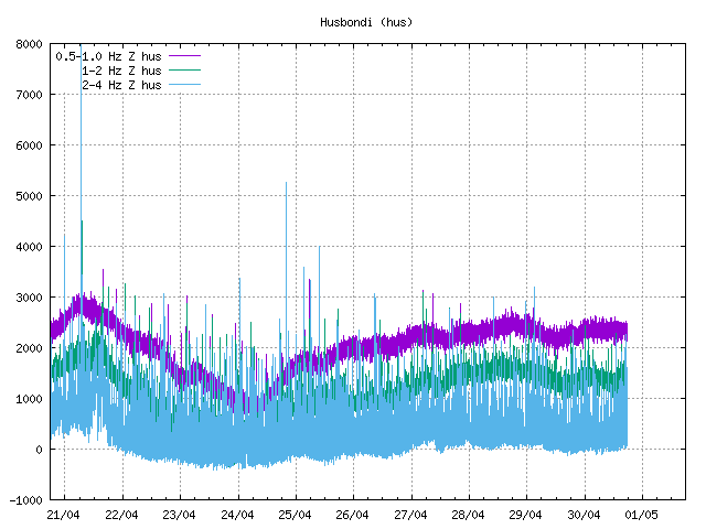

and Mr. Grimsvoten’s
Certainly not weather. Could be just summer Ice melt causing less pressure and so water activity. or Grimsvoten just settling after his last episode.
Looking at drum plots Hus looks busy! yes larger quake and Askja is restless.. are we seeing more tectonic movement? or is it the Plume? Any more expert people out there to help please?
Has been downraded to 2.2
….and for those who think we are only interested in Iceland here’s one to keep an eye on! Pavlof tends to show off now and again and is restless much to the annoyance of airlines that may fly that way!
https://www.avo.alaska.edu/activity/Pavlof.php
And I am quietly watching Beerenbers antics. Iceland is just not far north enough it seems 🙂
Where can we see Beerenbergs antics?
At h_ttp://hraun.vedur.is/ja/drumplot/drumplot/jmi.png?0.5291209856527651 (just remove the underscore splitting the http).
There’s a webcam somewhere too.
http://www.jan-mayen.no/webcamera2.htm
tell me more.. Is that after yesterday’s M5 ? An eruption there could be interesting
It seems there will be an article about it in the making. For being so far out you and me give it a lot of attention 😉
We like hard-to-reach places. Although Pluto may have been pushing it.
That’s more in line with normal activity at Grímsvötn.
Strange, I clicked reply to Bjarki’s comment about magnitude downgraded to M2.2.
Hi Carl,


(or other people with some knowledge)
Would you be so kind as to clarify these graphs to us?
grf2, grf9 anf grf18 from © IMO
(I mean : the aspect of all curves and the relative postion of the red curve with respect to the blue curve in these three graphs)
thkx
grf2 © IMO
grf9 © IMO
grf19 © IMO
Note to the moderator: Be nice! Remember that while most understand English, the finer nuances are only apparent to native speakers so show tolerance! In addition, some people doesn’t about wordpress and doesnt know how to post image. JPG=40K; gif=18K. Fill free to change what ever you want.
🙂
Hello!
The current interpretation is that there was an episodic increase in higher frequency tremor, we believe it to be water leaving the cauldron or hydrothermal activity since there is little or no change to lower (red) frequencies. The end of the last picture is showing what could be seen as baseline activity at Grimsvötn.
Carl: thanks a lot for the answer
Albert: Thanks for the great post.
Thank yoj, Albert, for this informative series that even I can understand. Looking forward to part 3.
I have forgotten to thank Albert for his Plutonian articles. Splendid read indeed!
And while we where looking away our friends at IMO has been busy adding stations around premierily Grimsvötn, but also a couple around Bárdarbunga and Askja. Especially interesting are the URH, BJK, DJK, KIS and THO stations.
http://hraun.vedur.is/ja/drumplot/mapDRUM.php
Example from DJK:
 ?0.06252929866626039
Oh, I am waiting for the first exo-planet volcanism article from you. 🙂
How did this end up down here?
Seems like the comment-tree is out of whack.
I noticed this earlier…. I of course thought it was just me……. 😀 Geat! I have found another marble!
replying to see if it goes to the right place!!!!!!NO it isn’t in the right place!!!!!!!Give it a good whack! It’s all over the place!
I think someone removed a comment and it shot the comment tree.
That is why we never should remove a comment, far better to just empty out the comment.
Oh, I am waiting for the first exo-planet volcanism article from you. I think I know what this was in response to. It is still hard enough to know which planets are gas giants and which have solid surfaces. There is one planet reported to be mostly carbon. That could give impressive volcanoes.
The worlds foremost volcanologist, Haraldur Sigurdsson, has spoken up about the problems at Icelandic Met Office.
It has been a badly kept secret the last couple of years that things are not working as it should there.
Among other things data is nowadays withheld or delayed and it is no longer scientists writing the bulletins, instead it is a political group writing them. IMO has also stopped cooperating with EMSC-CSEM.
I am grateful that such an astute and revered scientist as Haraldur Sigurdsson has poked a hole in the lid on this scandal.
Sadly things will be up in the air for a while and I hope that the new government will listen to Haraldur and do what is needed, put IMO back in the hands of the Icelandic scientists.
http://vulkan.blog.is/blog/vulkan/entry/2179408/?fb=1
For goodness sake let’s not have a repeat of small minded behaviour like those on El Hierro. US Brits are better than that!
Ed: Edited / H
I didn’t know that there were any US Brits left. Go figure…
Oh Dear Lurking , I should have used the Royal “We” . A very bad grammatical error on my part . I feel so ashamed that this was noted by you, a Non Brit or should I say an ExBrit? 😀
There are better ways to handle this. Better that IMO writes its own bulletins.
Ed: Edited / H
OTH, the important issue is that there is no delay in IMO having critical data so that it can issue a timely alert when they needs to.
Ed: Edited / H
If they take up the ideology of Nemisio Perez, someone is gonna get killed.
Karen I agree wholeheartedly.
What worries me is that I read somewhere that the alert would not be raised for Katla until the magma reached the ice-cap; the ice-cap is believed to hold the magma / lava for 60 to 90mins before an eruption. 60-90 mins is a bit short to give airlines time to respond – London VAAC, please note.
Ed: Edited / H
The good news is that Albert does not think that UoM is involved – see below,
Albert, don’t you work at Manchester Uni – have you heard anything about thts on the academic grapevine that you can repeat without breaking confidence?
(seems that an inordinately large fraction of VC contributors are in Manchester!)
There are no connections between the IMO and the University of Manchester that I am aware off. UoM is a scientific institution with a large range of projects and expertise, but the professor of volcanology works mainly on other volcanoes (he knows a lot about Etna). The atmospheric physics group has worked on the dispersal of the 2010 ash and found that it was a bit unusual: under most weather conditions that time of the year it would have gone west rather than east. But other than that, nothing.
The blog it links to complains about the problem in accessing recent GPS data, but I see that people here have had no problems locating these.
When going on vedur.is and looking for GPS data, the first and most obvious link goes here http://en.vedur.is/earthquakes-and-volcanism/gps-measurements/ in which the data you can find, stops recording at some point in 2014.
If I hadn’t paid attention here in VC, there’s no chance I’d have found out where to find up to date GPS data.
Your average Joe will check the official site, look for the most obvious links etc and find old data, and get mighty annoyed, something I fully understand. There’s no hint that you can find the info you are looking for over at jardvis.hi.is.
The blog complains about IMO’s website being terrible not up to date, which is where the public will be looking for info, and find it missing. (that’s how I read it at least)
Thank you for that Albert. I thought it odd but these days nothing seems straightforward. You actually cannot find recent GPS data on the IMO site which should be available to the public especially the Icelandic Citizens who pay for it!
We are a little more savvy about finding data in which we are interested. Your average student or interested person may not easily find it. (One good reason to follow a well presented,unbiased and accurately informative blog and discussion group.)
I apologise to UoM if I have jumped in and believed something which is untrue. But I do think there has been a gagging event here with some group either annoying the IMO or some politicians doing what politicians tend to sometimes do, namely interfere with scientific institutions or findings they do not readily understand! Well! perhaps I am being a little harsh there, but so often from an Ecologist’s view I see damaging decisions made concerning the environment where the politicians have been given false information.
The commonly accepted statement that “Britain doesn’t experience earthquakes with the magnitude of Fukushima” is given to assure the safety of the building Hinkley Point Nuclear power station. This location is on a wide river estuary open to the Irish sea, that has historically seen catastrophic flooding by either a storm surge or a tsunami type event. A Nuclear incident there would have a huge impact on the environment. I won’t rant on I just get angry when the safety of any citizens no matter where in the world they live is compromised by ignorance and greed of those in power.
The UK has had eqs in the region of Mag 6 in the past, albeit very infrequently, so any nuclear power station should be earthquake proof, not built on an active fault and tsunami proof. Is all that in the plans for Hinkley Point?
It is in an area with a history of storm floods, but not earthquakes. The main earthquakes in the UK happen on the other side, around Kent, and some in northwest Wales. Only minor earthquakes occur elsewhere. I don’t know how high the site but the maximum height of storm floods is predictable.
Hinckley Point is in the Bristol Channel. Although further to seaward than the peak point of the tides (Avonmouth), it is worth noting that the area is subject to one of the very largest tidal ranges in the world, with a low-to-high rise of approx 15 metres on the very biggest tides (when measured at Avonmouth). This is because the bathymetry of the estuary is an excellent natural amplifier of incoming tides and surges. It is also the site of the largest natural disaster in British history (the Great Flood of 1606/7).
The vast majority of the landscape in the area is formerly marshland and is thus very low lying, with spot heights as far inland as Glastonbury typically in the vicinity of less than 5 metres above sea level.
I don’t know the specifics of the landscape in the immediate vicinity of Hinckley Point, but I sincerely hope that sufficient thought has been given to such factors.
In the Severn Estuary, the area seems to be on the receiving end of a major flood caused by a surge roughly every 400 years…known by some as “supertides”. The last such incident was that flood of 1606/7. Like volcanic activity, however, these events are not like trains, and thus do not run to a timetable.
Here’s the Giggle Trans version of Haraldur’s blog:
IMO maintains a remarkable site, which provides real time information on various aspects of geophysics Iceland. It is perhaps unique in the ground and very commendable, the public should have direct access to seismic data, so to say as soon as they appear in the Meteorological Office. We who do not work at the Meteorological Office have thus been able to follow closely the development of the seismic volcanoes and fracture zones of the country in real time. The well-informed and interested person Icelander can thus view and interpret the data as soon as they are received járðskjálftafræðinganna. Thus it should be, and geophysical data should be equally accessible and data on weather in the country, especially considering that this data is collected for the public on the government.
In addition seismic data has also collected Meteorological talk about GPS tracking in the country. They are ómissnadi [= “indispensable” am57’s translation] for those who want to track horizontal or vertical movements of the earth’s crust under us and the volcanoes. In some respects GPS measurements more important than seismic data, the crust movements are crucial and can be important to predict the dynamic movements and even volcanic eruptions. This was particularly evident in the metabolism of the caldera [= Bárðarbunga] and the volcano [ = Holuhraun] recently. [Additions by am57: Icelandic: “Þetta var sérstaklega áberandi í umbrotunum í Bárðarbungu og Holuhrauni nýlega.”]
But as it happens, that halfway through, just when most went on the caldera and the volcano [Bárðarbunga and Holuhraun (am57)], then turn off the GPS Meteorological site. Replacing this message: “New web regard GPS tracking is being built.” The last data published now surpassed two years old: “Last data point 18 Jun 2014”.
Why there is this silence? Usually when a new website is under construction, then use the old web site until the day of the new is ready and there is no risk of access of data is broken. So is not high Met. Can it be that the IMO is more to play in the construction Nyan site for more than two years? Can it be that the IMO will block access to these GPS data for some reasons strangers? Will they prevent that other researchers may benefit from? It was probably a violation for official body to this, as difficult to imagine that such a spirit realm in the town …. but who knows?
********
A quick visit to the IMO earthquake pages and then clicking through from the GPS link shows that Haraldur is right: Iceland’s own citiziens — who elect the government which funds the IMO and who stand most to be affected by any eruption and therefore most need current GPS data — cannot get access to that data via the IMO website’s own link.
Anyone want to buy some shares in tin foil?
http://icelandmonitor.mbl.is/news/nature_and_travel/2016/09/04/misleading_information_on_katla_eruption_says_icela/
Wonderful, phlegmatic and level-headed Icelanders!
Posted before reading Carl’s post…
Interesting article on Etna covered here, https://www.sciencedaily.com/releases/2016/09/160902111257.htm although the writing leaves a lot to be desired.
BBC has a long article about drilling at Campi Flegrei http://www.bbc.com/future/story/20160902-the-bold-and-controversial-plan-to-drill-into-a-supervolcano?ocid=fbert
Another great article Albert. My youngest daughter has always had her head in the stars. I’ve encouraged it thru the years. (another subject I’m fond of.) Her favorite is Jupiter. I think she’ll find this interesting. I’m emailing it to her at college. Maybe She won’t say “I know mom.” 🙂
Birds captured taking off, on radar just before the Oklahoma earthquake the other day. http://giphy.com/gifs/3o6Ztr3PaGQNa3sREI
I just found that you can actually find GPS data through IMO website, but only on the Icelandic version of the site.
Go to earthquake page, and then “Grimsvotn-eldgos” out to the right. Then the link called “Vöktun Vatnajökuls” and then scroll to the bottom, where you’ll find a link to this https://notendur.hi.is/runa/eyja_gps.html
However that’s quite a detour, which most people probably won’t try to find.
This was a response to am75 further up, but the comments are a bit all over the place these days.
This can happen sometimes.
A comment was removed and trashed, and someone tried to answer that comment while an admin did it. And that always porks up the comment tree completely. That is why we should always remember that it is better to empty out a comment instead of removing it.
It will correct itself as we go to a new post.
Thanks, Bjarki.
I ought to have checked the Icelandic pages before posting my comments about “Iceland’s citizens” since most of them will have Icelandic as a first language, so I am glad to read your comment. As you say, the GPS data is quite well tucked away on the Icelandic pages, and even then the display on the Voktun Vantajokuls GPS page ends at 2012, necessitating the further move to another page.
We ought not to be too critical of the IMO but it does seem odd that there is not yet any link from the GPS button to the actual, current data that persistence discovers.
IMO might be a bit lazy/messy on their site, with some scattered info and such, however that’s absolute peanuts compared to INGV in Italy, their info is scattered over dozens of pages, many who look like they were designed and last given an overhaul in the 90’s. And that’s if you know the language… Good luck if you rely on things being English.
I’m italian and i have to say that Osservatorio Vesuviano has the worst web divulgation data in the world. It seems that volcano data are a national secret; we pay a service that doesn’t exist. They give us only the worst sismographs in the web, almost unreadable; we have not real time gps data, neither geochemical, and earthquake catalogue is update very very slowly. Last OV director was removed some months ago, we’ll see if something change with the new one, and with the legal actions of some private citizens.
IMO compared to OV is the heaven of volcano data divulgation.
Excuse me for my bad english.
First I have to say what outstanding articles by Rene and Albert that continues the tradition of this blog being first rate and the best read on the topic that can be found anywhere.
I believe the University of Cambridge is the one closely affiliated with IMO
Also, do not believe that IMO intentionally goes out of its way to hide things from the public, I think they are either too busy or maybe even too sloppy to do things that make it easy to find information
They did an new GPS site but failed to update the main website to link to it. It is also half done, there are many many examples of this half done work throughout the website.
Just like they have added two new webcams, one looking over BB and one over Katla but do not link them in a way that they are easily found.
I have found over the years this is the pattern, the info is there, it just has to be mined
Example, here if the link to an amazing study of the 2011 Katla eruption that would have been very interesting to many people but the link is buried. It is very large so takes a while to download.
http://brunnur.vedur.is/pub/bgo/katla/agu11-bgo.pdf
I found examples of quake waveforms that clearly show the pattern of quakes changed and suggested the collapse has now changed to inflation in BB, information was hard to find but was there, not hidden.
Bottom line, there is no conspiracy to hide things from the public, just a bunch of people who are more interested in the data than making good websites
As I said in my comment a few moments ago, we shouldn’t be too critical of the IMO. However, Haraldur has a point: the IMO may be “just a bunch of people who are more interested in the data than making good websites” but the website is there for the benefit of people who live within range of 10cms+ tephra deposits from Katla.
So, some of the IMO info is science, some of it is live data: the two overlap, as do ECMWF data and the BBC’s weather pages. But as I understand it, the IMO’s silent GPS pages are analogous to the surface pressure pages being silent on the BBC’s pages.
“Conspiracy”? Maybe not, but if I were a deepwater fisherman, I’d be entitled to be a bit grumpy about that and to wonder what’s going on.
If it is IMO’s mandate to protect the people of Iceland then making nice websites one could argue is not really a priority.
The information is out there
All the drumplots
http://hraun.vedur.is/ja/drumplot/drumplot/
All the GPS stations with more info than anyone would really care to look at
http://brunnur.vedur.is/pub/fjalar/gpsTimeSeries/
Now I have been looking at this info for years now and still struggle to make any sense out of it
The IMO’s job is to watch the data and inform the public when there is a risk and how big of a risk they are facing.
Having politico’s write news releases is more the norm today in the world of viral media, especially when you have to deal with the Daily Mail types.
Correction
This is the correct GPS link
http://brunnur.vedur.is/pub/gps/timeseries/
PS – thanks for the link. You make an important point: It can be surprising just how much material the IMO gives open access to if you dig around on their pages.
I do not know about IMO and my purpose is not related to IMO or Iceland.
Sometimes, regarding volcanoes, public authorities do not give too much information for fear of the economic costs (evacuation of people, tourism, etc…..) or uncontrolled population movements.
“CO-SEISMIC DISPLACEMENTS FOR THE AUGUST 24, 2016 ML6, AMATRICE (CENTRAL ITALY) EARTHQUAKE ESTIMATED FROM CONTINUOUS GPS STATIONS”
http://ring.gm.ingv.it/?p=1284
A bunch of info on how the ground moved during the quake.
By clicking on “network” up in the top, you can find whole lot of GSP stations in Italy. (more can be found in the various links in the article)
Philae has been found! In darkness, as expected. Just in time as Rosetta itself will shortly be put down on the comet for its eternal resting place. We won’t hear anything from Philae but it is nice to know what happened to it.
http://www.bbc.co.uk/news/science-environment-37276221
Yes – I was so pleased to see it there. The ruggedness of the landscape there is stunning!
Ah, I mean pleased they FOUND it there, not pleased that is ended up there. Sorry.
And non-Iceland or extraterrestrial: the earthquakes on Mauna Loa are getting shallower. There was a bunch today at only 2km depth. Earlier it was mainly 3-4 km. This will probably quieten down again, but worth keeping an eye on. I did wonder whether rain from the tropical storm had anything to do with it but it is a bit deep for that!
Is that where the Hawaiian observatory which measures high CO2 is located? What depth is the magma chamber / reservoir under Mauna Loa?
Maybe feeling left out? Wants to remind us it’s there waiting? 😀
Here’s an unbelievable story coming out today in Iceland
During the weekend some goose hunters who were hunting east if Mýrdalsjökull stumbled up on a viking sword dating from 950 A.D that was pretty much lying on the ground before them.
I’ve been waiting all day for an explanation as to how that was even possible.
Apparently the sword was located where a glacial flood occured last fall from Vatnajökull. The flood broke the ground at the spot where the sword was found, explaining why it was just lying there on the ground.
An even more amazing fact about this is that the pagan grave that the sword belonged to, was actually before the flood, under the lava produced by the Laki eruption.
http://icelandmonitor.mbl.is/news/news/2016/09/05/video_viking_sword_was_just_waiting_to_be_picked_up/
And everybody had thought they were on a wild goose chase
I thought it can be interesting to post… Atlantic “weather bomb,” or a severe, fast-developing storm, causes ocean swells that incite faint and deep tremors into the oceanic crust. These subtle waves run through the earth and can be detected in places as far away as Japan, where facilities using a method called “Hi-net” measure the amplitude of the storm’s P and S waves for the first time
http://m.phys.org/news/2016-08-japan-scientists-rare-deep-earth-tremor.html
What with all the excitement about conspiracies to conceal eruptions from the good citizens of Iceland (OK – British irony: forgive the exageration), I omitted to say to
ALBERT, thank you for the very interesting article. It reawoke the 8 year old boy in me.
One thing: I can understand the gravitational sling-shot effect, but what I don’t understand is how thrusters can work in a vacuum.
Inertia. The force needed to eject gas from the thruster provides opposite to what is thrown out. The more forcibly it gets ejected, the greater thrust you get from doing so.
Any reaction engine works on the same principle: unbalanced pressures. Consider an inflated balloon. The pressure is equal on part of the inside of the balloon – in every direction.
Now release the neck of the balloon. That leaves a hole there. There’s nothing for the air inside the balloon to push against there – so the pressure on the *front* of the balloon – opposite the neck – is no longer balanced by any opposite pressure where the neck is open. So the balloon flies forwards. This drawing explains:
And any reaction engine works *best* in a vacuum – because there’s not even the small ‘back pressure’ of the atmosphere to reduce the net thrust!
Thank you, gentlemen. I imagine I must have had that explained to me in a physics lesson once upon a time, but without the elegance and concision that make for memorable explanations like yours.
hello, Henrik, Carl,and all the other volcanoholics with a bit more expertise then myself, please take a look at the Mauna Loas southwest rift zone m3cam. Am I right in noticing what looks like smoke coming out of the rift area? My view was at roughly 2:50pm PST. thanks for your input
Looks like some smoke or steam to me.
Mac
There were 3 shallow quakes up there in the last 3 days, 2.4 km or less. The time stamp on the photo is 16:10 sept 4th Hawaii time.
Mac
Nothing too exciting… no HT… yet anyway!
I thought that this webcam was up near the current seismic activity a little south and west of the Caldera. When I look at the map ( linked below) of the camera locations it shows it way down the rift just above and north of Ocean View.
http://hvo.wr.usgs.gov/maunaloa/current/currentmonitoring.php
Mac
Maybe around here, unless it has been moved.
Mac
19.213849, -155.742215
Definitely steam, not sure if a it’s normally there, or whether it’s a new development. If it’s related to the quake activity, maybe something was dislodged or there’s new cracks? Possibly even weather/groundwater related? If I had to guess, it’s probably nothing, but for sure I would be somewhat nervous if I was there. There’s a good chance that when the eruption does come the situation will escalate quickly; Mauna Loa isn’t exactly known for giving much advanced warning prior to onset. With all that inflation in the last 12 or so years, surely we can’t be far from the inevitable. I wonder how quickly evacuations could be done; there may not be much time to get moving! To be fair, I know the HVO staff are very competent, so there’s probably not much need to worry. Anyone familiar with what’s normally seen on that cam?
Thank You everyone for your input, sorry about the wrong day and yes the HVO staff are awesome.
Blue line tremor up across several stations in Iceland.
Especially round Vatnajokull &. here at Husbandi. This graph show what I think is a harmonic tremor type signal where the red, green and blue all show rises and falls of similar magnitude together. This does not necessarily mean an eruption the other likely scenario is a Glacial flood.. These signals are showing all round Vatnajokull and a little beyond so it is something quite large. It isn’t weather as it is not showing in other areas and it is not really local Grimsvoten SIL signals haven’t changed. Do remember this icecap covers several volcanoes as well as the ones most frequently considered.
This paper shows other volcanoes beneath Vatnajokull and highlights the difficulty for Volcanologists to interpret signals from beneath this huge glacier. Worth a read before you get overly excited by the assortment of signals that show up on the SILS.
http://jokulljournal.is/40-49/J40p147-168.pdf
Thanks to HELGI BJORNSSON and PALL EINARSSON, UoI
What are the nearby rivers doing?
SLY could be interesting too.
http://hraun.vedur.is/ja/oroi/allarsort.html (scroll down to reach SLY)
Oh yes! You are right There! Karen 🙂
🙂
Something is on the move around Herdubreid / Askja. Within the last days there have been some small swarms and recently some quite deep ones:
Tuesday
06.09.2016 07:47:58 65.121 -16.616 22.8 km 1.0 99.0 9.2 km N of Dreki
Tuesday
06.09.2016 07:42:48 65.113 -16.594 18.7 km 0.9 99.0 8.3 km N of Dreki
Monday
05.09.2016 10:18:30 65.103 -16.638 23.3 km 0.4 99.0 7.4 km NNW of Dreki
Monday
05.09.2016 09:59:16 65.102 -16.608 24.5 km 0.9 99.0 7.0 km N of Dreki
It is important to separate what is going on.
The first swarm area is Herdubreid, it is an old intrusions that has meandered over the years from Upptyppingar to under Herdubreid where it has gotten stuck. The question here is what will happen in the end, and eruption or a steadily dwindling intrusion that never surfaces? Nobody knows.
The second swarm is most likely an injection of magma from depth into Askja, what effect it will have in the future is interesting, but so far the activity lacks the “Umpf” to cause an eruption in the near future.
The third interesting thing in the area happened more to the south where there was a deep earthquake at Trölladyngja shield volcano. Prior to the eruption of Holuhraun there was a few deep earthquakes there.
Tuesday 06.09.2016 11:12:21 64.892 -17.219 25.9 km 0.5 99.0 1.5 km ESE of Trölladyngja
I find this link useful to get a broad view of tremor for Iceland.

Thought I was posting the link rather than the image. Credit , source is from :
 “. Give the current info each time you visit.
Out to Beerenberg and Beyond!
http://www.volcanocafe.org/activity-at-jan-mayen-and-the-hotspot-conundrum/