
The pillars of Pozzuoli: the frontipiece of Charles Lyell Principles of Geology (1831)
In hindsight, continental drift should have been obvious. That the Earth moves up and down had been known for centuries, shown by the layered beaches of Sweden, the seashells of the Himalayas, or the sinking harbours of the Med. The drowned and resurfaced Pillars of Pozzuoli became famous as the frontipiece of Charles Lyell’s opus magnus, Principles of Geology (1833). If up and down is possible, why not sideways? The close relation between the coasts of Africa and South America was obvious to everyone. But science, ruled by conservative geologists, blocked this obvious step.
Don’t judge these senior scientists too harshly. The physics of continental drift is still far from straightforward. There was no known source of sufficient energy within the Earth. Convection in solid rock was unimaginable. The data spoke loudly, but in an unintelligible language. It needed translating and interpreting. Science stuck to things it understood. It kept its feet firmly on solid ground.
Only in the 1960’s did the tide change. The mid-oceanic ridges had been discovered, and the oceanic crust dated. The ages left no doubt that new crust was being created. Even the most conservative geologists could no longer deny the flood of evidence. Continental drift became accepted, 200 years delayed. Let it move.

The 15 major plates. Source: wikipedia
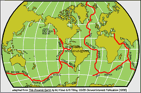
The main mid-oceanic spreading ridges
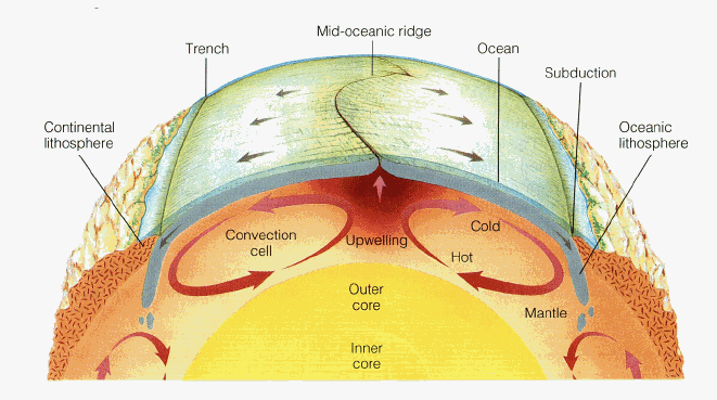
We now know of 15 major plates, each moving independently from the others. Most of them contain a continent (the North America plate covers more than one) but some are purely oceanic. In between the plates are the spreading ridges and subduction regions. All active spreading ridges are oceanic, even if some (such as the Red Sea spreading ridge) started on land. The answer to how continental drift works lies underneath the sea.
See it move

The increasing distance between telescopes in Germany and the US
The spreading rate of a typical mid-oceanic ridge is 5 cm/yr. As every book on the topic says, it is the rate at which finger nails grow. Nowadays we can measure this directly. Radio telescopes measure the exact direction to distant galaxies. Over the years, this direction changes as the ground underneath them moves. Compare two telescopes, and you can measure how the distance between them changes. This is accurate to millimeters. The figure shows the increasing width of the Atlantic, measured between two telescopes. You can see the slow, smooth movement, with an annual fluctuation. The rate of increase seems slow, but this is because the baseline crosses the spreading ridge at an angle and does not see the full movement.
But what is it that makes the continents move? The main action is clearly in the oceanic plates. But what force can make the surface of the Earth drift? Physics tells us that there are four different processes at work. In increasing order of importance, these are:
Magma injection The magma injected into a spreading ridge can push the two sides apart, and set the plates in motion.
Convection currents The convection currents in the mantle can themselves induce horizontal motion, because upwelling and downwelling occurs in different regions. The flow in the mantle can drag the crust along.
Gravity Spreading ridges are pushed up by several kilometers. Subduction occurs in deep trenches. Gravity causes material to move from high (spreading ridge) to low (the trench). This is called ‘ridge pull’. (It is also called ‘ridge push’ but this is misleading as there is no push from behind.)
Subducting plates As the slab sinks, it pulls the rest of the plate with it. This is called ‘trench pull’ or ‘slab pull’.
Slab pull is now considered the most important effect, followed by ridge pull. Horizontal convection currents in the mantle would affect the continents most, since they have deep keels sticking into the mantle, but this is not observed. Instead the continents seem to respond mainly to the oceanic crust. Ridge pull is important, but magma injection by the rising mantle, which would seem to be the most obvious way to drive plates apart, does not work as a force.
Spreading ridges and plumes
Mantle plumes are different from spreading ridges. They produce ‘hot spots’, seen in places such as Hawaii. They are deep, rising, convective cells, which reach to the surface and by their heat, push it up. Magma forms, and a tall volcano appears. It grows tall not just from the lava deposited on top, but also from the push from below. Once the volcano drifts away from the hot spot (the curse of continental drift: it is hard to stay in one place), the mountain quickly sinks again. This will be the fate of Hawaii. Hot spots do not form spreading ridges: Hawaii did not break the Pacific plate. This shows how ineffective magma injection is in setting plates in motion. However, sometimes a hot spot does break a continent, forming a triple junction which can develop into a new spreading centre. Africa has been susceptible to this. But it is rare, as shown by the fact that neither the Yellowstone hotspot nor the Deccan Traps broke their host continent.
There are cases where a hot spot coincides with an existing spreading ridge. Iceland is one example, the Azores and Amsterdam/St Paul are others. Are these accidental? If so, the hot spot should rather quickly drift away from the spreading ridge. But this is not seen. Iceland is at least 20 million years old, and it is still largely centred on the continental divide. The reason may be gravity pull. The hot spot pushes a region up. Gravity pull begins to act. If there already was a plate break nearby, the plate may now begin to break at this point, letting the old break nearby stop and heal. In this way, a hot spot can pull a spreading ridge along, at least for a while.
Hot spot volcanoes are common on Mars and Venus, as they are on Earth. But spreading ridges and continental drift only occur on Earth. We are unique.
Mantle

From www.zmescience.com/science/physics/magma-peridotite-crust-mantle-10012013/
The mantle extends from 100 km depth to almost 3000 km. It is solid material, not liquid, although it can move around as well as up and down. If this seems strange, think how sand can do the same. The mantle rock changes at a depth of 410 km, and again at 660 km. The higher one corresponds with a change from olivine to spinel, and the lower one a change to perovskite.
Subducting plates are cooler than the surrounding rock, and go through the first phase change a bit earlier. This increases their density while the surrounding rock is still of lower density olivine. This increases the downward pull on the subducting slab. Most of the slab-pull force comes from this phase change. Subducted plates often, but not always, stay above the deeper discontinuity: there is a ‘plate graveyard’ at this depth.
The phase changes can stop convecting cells from rising. Only strong convective cells break through them from below. If a cell gets stopped, it develops a broad plume head, creating a larger region of warmer material. So there may be two layers of convection in the mantle, separated by the discontinuity, with only a few hot, deep plumes being able to rise through both.
Convection
What causes the convection in the mantle? Convection forms when there is a large temperature gradient. The hot material at the bottom has lower density, and the buoyancy causes it to rise. Convection can be triggered either by heat from below, or cooling at the top. Mantle convection probably has both effects. The heat from below can come from the core (from the slow solidification of the inner core), or from radioactive elements in the mantle itself. Cooling at the top can come from subducting plates, or from water cooling of oceanic plates. The convection can be deep, from the core, or be in the upper mantle only, driven from the 410km phase discontinuity. Underneath continents, sideways convection can occur, from hot regions near the centre of the continents (where mantle heat is trapped) to the cooler edges. Perhaps these also happen from the warm mid-oceanic ridges.
Numbers
Let’s try to put some numbers in.
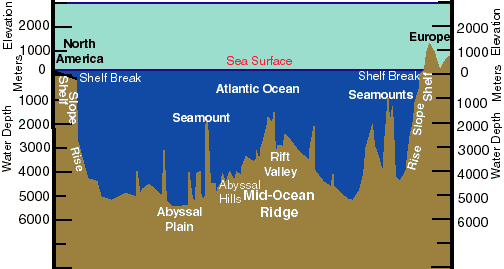
The total length of the spreading ridges on Earth is a staggering 40,000 km. The oceanic crust is about 8 km thick. For an average spreading rate of 5 cm/yr, we need to create 16 billion cubic meter of basalt every year (length times width times thickness). The density of basalt is 2400 kg/m3, so that 38 trillion kg of basalt is added to the oceanic plates each year. Obviously, the same amount must be going down in the subduction zones each year, to keep the Earth in net balance.
The new basalt coming up from the mantle is hot. It cooled down while coming up but it is still hotter than the normal oceanic crust. Because it is warmer, it has lower density. This buoyancy pushes the mid-oceanic ridges up, to 3-4 kilometer above the ocean floor.
Let’s assume that basalt within the spreading ridge in the ocean has a temperature of perhaps 1300 C. As it moves away from the ridge, pulled in by slab-pull and by gravity, it cools and grows denser. Let’s assume that once it reaches 800 C, it begins to subduct. (The numbers are approximate but not far off. Obviously the surface is much cooler and these numbers are for the bottom of the crust.) The heat capacity of basalt is 0.84 kJ/(kg K): in other words, to cool 1 kilogram of rock by 1 degree centigrade releases 840 Joule of energy. Cooling by 500 degree centigrade releases 0.4MJ per kg of basalt, between upwelling and subduction. This is a lot of energy. For 1 square meter of ocean floor, and 8 km of crustal depth, the total energy to be lost is 8 TeraJoule (8 x 10¹² J).
Rock insulates very well and it gives up this heat very reluctantly. The k value of basalt is 1.69 W/ (m K), which means that for each degree of temperature difference, a 1 meter thick rock layer lets out 1.69 W per square meter surface area. A 1 kilometer thick rock reduces the leakage to 1.69 milli-Watt. So how long does it take oceanic crust to cool down from 1300C to 800C? Take the average thickness as 4 km, and the temperature difference with the surface 800 C (the deep ocean being 4C). A quick calculation shows that the ocean floor near the ridge will radiate about 0.34 W per square meter.

At this rate, the cooling will take a million years. This sounds like a lot but in geological terms it is fast. However, although the initial cooling is fast, it slows down a lot later, when the temperature difference is much less. Cooling continues for typically 100 million years.
As the rock cools, it contracts and becomes denser, and the ocean floor begins to sink because of the contracting rock: the sea grows deeper over time. The approximate relation is that the depth of the ocean is 2.5km, plus 0.35 times the square root of the age in million of years. At zero age (i.e. the spreading ridge) the depth is 2.5 km. After 1 million years it is 2.85 km, and after 100 million years, the ocean is about 6km deep. After this it increases only very slowly. Therefore the oceans are least deep at the spreading ridge, and after about 1 million years, when the floor has moved by about 50km, it rapidly becomes deeper. The spreading ridge is therefore typically 100 km across.
From http://oceansjsu.com, copyright San Jose State University
The plate is actually much thicker where it forms, and thins further out as the movement speeds up. Eventually the oceanic crust cools so far that it become denser than the pressured mantle (aestenosphere, to be precise) below. Once this happens, the ocean plate begins to sink, like blobs in an old-fashioned lava lamp. Let subduction begins.
Subduction reheats the sinking plate. It comes in an area where temperatures are much higher and sucks up this heat. The sinking and the higher pressure itself also generate heat. After 100 million years of solitude, the plate can get cozy again in the homely warmth of the upper mantle, returning to its Macondo, and dissolve in the plate graveyard.
Volcanoes
Volcanoes occur in two part of this cycle. The spreading ridge itself is effectively a 40,000 km long volcanic rift, producing gigantic amounts of basalt. Images of the ocean floor clearly show a rift, situated in the centre of the ridge. Most of the basalt is injected far below the surface; only a small fraction is erupted on the surface. Sometimes a ridge becomes overactive and floods the sea floor with thick layers of basalt, as a LIP (or Large Igneous Province). The largest such event known is Ojong Java Nui, which covered as much as 1.2% of the Earth, and was emplaced below the sea 125 million years ago. Ridge volcanic activity is well behaved, with stuff oozing out. The pressure of kilometers of seawater above is too high to allow for explosive ejection. These are the only types of volcanic eruptions which attract rather than destroy life.


Giant tube worms and a scary-looking
spider crab near deep sea hydrothermal vents.
http://www.photolib.noaa.gov/htmls/nur04512.htm, http://www.photolib.noaa.gov/htmls/nur04511.htm
This volcanic activity quickly dies down as the plate cools, and the plate becomes inert apart from the occasional hot spot or warm region it traverses on its journey. Where this happens, a volcanic island may form. All deep sea islands (apart from Australia) are volcanic in origin.
The second phase of volcanic activity occurs during subduction. The oceanic plate is solid. As it subducts, both temperature and pressure rise and a race begins. The melting point increases with pressure. If the temperature increases faster than the pressure, a bit of melting will begin. In practice, this may happen at certain depths, and the plate becomes solid again as it goes deeper still. The subducting plate probably contains water (the upper range of the oceanic plate becomes pretty wet, as you may imagine) and this lowers the melting temperature. Once rock melts, it becomes less dense and buoyancy pushes it upwards. The result is volcanic.
Let the dance commence
Therefore, continental drift begins with a cool surface slab descending into the mantle (‘the enemy’s gate is down’). This pulls oceanic crust with it, and some distance away the crust tears in response. The tear creates a gap, and the underlying mantle floats up to fill the gap, forming a new hot surface. Below, more material comes up from the mantle, carrying its heat with it. All activity happens below the sea. The continents are floating on the oceanic crust, passive and driven by the whim of the oceans.
Spreading ridges thus form by tearing crust asunder. Convective mantle cell are not needed. The mantle does have convective cells, forming hot spot volcanoes. As a rule, hot spot volcanoes have magma that comes from very deep in the mantle, pristine material that has not been to the surface before. Mid oceanic ridges have magma from shallow mantle sources, that has been through several cycles, lacking some elements that ended up in the continents. Subduction takes the plates down to the graveyard, but only rarely to the deeper mantle. The shallow mantle is thoroughly processed, mixed, baked, cooled and wetted. The deeper mantle, source of the hot spots, has had a more sheltered life.
What we see on the surface is the stately dance of the continents. Now we know that this is just a veneer, driven by the far more rousing dance of the oceans which pulls and pushes the continents along. In turn, this is part of a lively upper mantle. Our solid ground is floating on a sea of trouble. There is danger in the dance.
Geolurking, bless him, pointed out the real origin of continental drift


Another 3+ magnitude quake at Bardy a little bit ago.
Never mind. Luisport already mentioned it. :p
I wasn’t expecting this after the big ones a few days ago, and I find the rising sequence interesting, though I’ve no idea what to make of the one at 05.54.
23.05.2016 17:37:47 64.619 -17.413 0.3 km — 3.4 99.0 6.0 km ESE of Bárðarbunga
23.05.2016 14:04:01 64.596 -17.206 16.7 km — 0.5 99.0 16.1 km ESE of Bárðarbunga
23.05.2016 12:41:14 64.565 -17.251 17.6 km — 0.3 99.0 15.6 km ESE of Bárðarbunga
23.05.2016 08:22:51 64.590 -17.277 26.8 km — 0.3 99.0 13.2 km ESE of Bárðarbunga
23.05.2016 05:54:56 64.624 -17.391 1.2 km — 1.1 99.0 6.8 km ESE of Bárðarbunga
I’m very much a learner at these things, but I’d say that magma was rising – ‘cept that there’s nothing (yet) on the tremor guages, and the quake doesn’t look volcanic on the drumplot – if that’s the right word: as I said, I am a learner and welcome correction.
There has been a balance between larger earthquakes on the NE and SE rims. Stress seemingly needs to be released in both locations. The SE side mainly has shallow quakes though.
Yes, I agree about the balancing of the stress release. I don’t think I’d expected this particular balancing sequence quite so soon after the last NE one; generally there seems to have been about a week before the balancing quake.
The other thing that interests me is the way in which the SE quakes seem to move upwards, which is something I don’t think I’ve noticed before.
Farmeroz @ 09.00: nice illustration. Question is, is it wiggling owing to gravity, or to pressure from below?
Is it that last year the intrusion was deeper and caused the caldera to sink and split open to the north and now it’s shallow and magma is actually filling the chamber? Just trying to understand the process.
Anyone who has tried to extract a roughly circular (and rough) part from a rough tube (think trashed bearing in a tube) knows that a straight pull always fails, the trick is to wiggle it from side to side whilst pulling. Basically due to the thickness it tends to tilt and jam top of one side and bottom of the other the diagonal being longer than the diameter. The wiggle briefly places the disk precisely horizontally when its is momentarily free to move until it jams again.
Royal Society Summer Exhibition – A friend has just sent me a link to this youtube video advertising an exhibition about the Bárðarbunga-Holuhraun eruption in 2014/15.
https://www.youtube.com/watch?v=BL5U28Icl2k&feature=youtu.be
There’s more info here:
https://royalsociety.org/events/summer-scien%C2%ADce-exhibition/exhibits/explosive-earth/
Looks like it’ll be well worth a visit for any volcanophile in or near London in July.
Thank you for this article! I remember reading eagerly the articles and the comments during the last Bardarbunga eruption, it was my first contact with volcanology. Now that I have some free time (holidays) I’m happy to be here again! Any comment on the recent trend in the tremor plots around Bardy? Looks like a drastic change… but as a newbie I’m not sure how to interpret it.
Replying to myself… I guess it means magma moving faster, meaning Bardy might erupt very soon. Right or completely wrong?
The last increase is 100% not magma. 🙂 it looks more like wind noise, but since it is so local to only this station, it could also be some hydro-thermal activity, which IMO has noted that it increased since last September.
There is nothing at Bardarbunga that would scream ERUPTION CONING, like hours away, but it is under close monitoring and with a good reason.
I am getting a feeling that even the IMO isnt in Kansas anymore, with Bardarbunga.
Yes, after some more reading I realized that high frequency is probably not magma. The thing is that Askja has the same rise and while now there is some wind it was very calm when the it started rising. I don’t know if hydro-thermal activity can cover such a large range…
I’m pretty sure bardarbunga isn’t in kansas… something that big doesn’t move around without making a racket.
Two stations, noise also in Askja plot. Bad weather?
And something entirely different: the Greenland April heatwave
http://earthobservatory.nasa.gov/IOTD/view.php?id=88048&eocn=home&eoci=iotd_readmore
And now nearly 18 hours with no recorded quakes; processing systems down? Web updates down? Only small quakes and storm masking them?
http://en.vedur.is/earthquakes-and-volcanism/earthquakes/
Oh and Etna is working up fast to another paroxysm – take a peek!
http://www.livefromiceland.is/webcams/bardarbunga-2/
Minor eruption on Hawaii. Pu’uO’o showed a sudden collapse this morning and new lava flows have started from the summit.
webcam http://hvo.wr.usgs.gov/cams/panorama.php?cam=PWcam
Anyone knows what’s going on in last hour? What is this sismic signal?
Looks like there’s some quakes at depth that IMO have updated … things get more interesting
Yes, several small deep quakes going on…
It’s interesting that the activity is concentrated 17.0 km ESE of Bárðarbunga and some on Grímsfjall http://en.vedur.is/earthquakes-and-volcanism/earthquakes/vatnajokull/#view=table
This is an intrusion occurring at the “Elbow” as we’ve come to call it. In other words, this is the place where magma turned north after leaving Bardarbunga, and headed on its way to Holuhraun.
Pretty clearly, it is a system in its own right. All these quakes form a nice little stack from around 25-14 km in depth.
It looks close to the saddle point on the rift. That was the reason the Holohraun intrusion paused here: the forces pulling north or south were almost in equilibrium at the saddle point.
I propose we call what looks to be the volcano at the “elbow” region beneath Vatnajokull “Olnbogi”, which is Icelandic for Elbow.
That has merit, but is it difficult enough to make a news anchor have visible distress trying to pronounce? To be really entertaining , they should literally choke trying to get it out.
How about hnakkurliðolnbogi = saddlepoint elbow (Giggle translate, of course)
totally sold on that, would that mean the nornahraun was the first eruption of the hnakkurlidolnbogi ?
I like it. See a news anchor getting their hnakkurs in a twist!
25.05.2016 21:33:50 64.616 -17.500 0.1 km 2.8 99.0 3.0 km SSE of Bárðarbunga
… Though it looks much bigger to me compared to the 2.7 of the morning.
Also 25.05.2016 22:03:30 64.618 -17.531 0.1 km 1.1 99.0 2.5 km S of Bárðarbunga
there was an M5.2 earthquake underneath Concepcion volcano in Lake Nicaragua. Worth keeping an eye on: this one has a history of earthquakes related to the magma chamber, and has grown more active over time.
A lot of deep small quakes in Vatnajokull glacier in several points and in diferent volcanos… i don’t remember to see this earlier… http://en.vedur.is/earthquakes-and-volcanism/earthquakes/vatnajokull/#view=table
Herðubreið is also shaking quite a bit.
Yes it’s true…. this one too.
Thursday
26.05.2016 15:17:45 64.647 -17.378 1.1 km 3.3 99.0 7.2 km E of Bárðarbunga
That is a new location for a larger quake. It looks like they are occuring more widely around the mountain now. Perhaps this is just due to inflation: an expanding mountain putting pressure on the surroundings.
This is getting even more interesting everyday! Thank you very much for your comment, it’s very interesting!
Why is this site suddenly moribund? Nobody’s making top-level article posts anymore.
“moribund”? The top level posts are generally driven by what is actually going on. Well, that and the wherewithal of one of us to have the time to craft something interesting about it.
I could relate the technical similarities of pheatic detonations to some biological phrnomena, but that topic would be mostly disgusting and I’m not into scatelogical humor.
oh pleeease do… mind is boggling now.
And thank you to all the contributors, whilst I’m here – genuinely.
No… can’t do that. It involved Newton’s 3rd Law and was most disgusting. I was down for 4 days without leaving the bed, and have only now gotten to the point where I can eat solid food. I also broke the latch on my treadmill trying to get to the restroom… in the dark. Luckily the dog ran the other way and he was uninjured by the falling belt-track assembly. He did come back to stare at me… but that was not helpful at all.
On a plus side, true to form he wouldn’t leave the side of my bed just to make sure that nothing could get me while I was down. My only viable weapon in such an event was a crooked stick, so I appreciated the back-up.
(The crooked stick is one of my prized possessions. It’s a hardened dried muscadine vine off of a tree from my Grand-dads place. It’s got an anomaly in it’s shape that fits the palm perfectly and it makes for a decent walking stick. It’s also good for poking at people in the dark if you get jumped. Whacking them, not so much. It would leave a welt, but not take them out.)
Sorry for being kurt. I do know that there is an article qued up that is mostly finished. It really only has minor revisions indicated. When it is released is at the discretion of them that decide such things.
Hi Kurt!
We could probably do with more people contributing posts. The main contributors have busy lives and it can be hard to find time to do more than one per month. Luckily the quality of the comments makes up for the posts! Always something new here.
… and along those lines, if anyone has an article to submit, the volcanocafe gmail addy is the place to do it. We aren’t shy about taking articles, as long as they are mostly on topic… accuracy checking will be accomplished via e-mail discussion. Just be sure to cite references so that we can maintain good order and friendly terms with the actual researchers. No, we aren’t gonna be format zealots about it, but we try to at least take an effort to cite the sources. As some have noted, we are amateurs and volunteers… not a journal. That way if someone tries to follow up on the data we can at least point them in the right direction.
I think you are being overly modest Albert! Each and every post I have read on here has been brilliant!
Thank you! But Fluid Dynamics point that new posts are not as frequent as they used to be is a valid one. One person of the VC team on holiday or being ill can have an immediate effect. It can be difficult to live up to expectations. But a new post is now in the making.
That may be so Albert, but I would like to think that everybody using this site appreciates the time and the research that goes in to each and every post. I, and I am sure I speak for most, am willing to wait for as long as it takes for the next post however long it takes. Remember – Quality, not Quantity! But, events often dictate!
Sorry, but I think that your comment is a bit unfair. So far as I know, this forum/blog is run by volunteers, many or most of whom have busy professional lives to lead and obligations to fulfill and who gain no particular professional benefit from it.
200+ intelligent and informative posts from all over the world in one week is, I’d have thought, far from being a sign of a site’s being moribund.
100% agree there. am57!
With this exciting BB development we do not need a new post right now. All the comments makes well up to make VC an interesting site.
Could the last strong quakes be steam explosions? Someone here who could interpret the drums? Could perhaps fit with the increased high frequency activity (blue graph)- water flow…
am57, you have hit on the principle item that keeps me around here. “informative posts from all over the world,” you see, I am a strong believer in collaborative efforts. Sure some comments may be a bit off the mark, but they force you to consider them just because they show up. In doing that it helps everyone in their understanding. Yeah, most of us are not experts in volcanology, but we do have bona-fide experts in many different fields that add to the collective thought train. Think of VolcanoCafe as a giant collective brain, mulling it over and working it out.
Thank you.
The wonderful thing about volcanology is that although it is as technical a branch of science as any other, the raw data is/are widely available and the basic principles of interpretation not too difficult for the non-scientific (humanities, in my case) amateur. So, when mistakes are made, it’s usually not too difficult to work out where one’s gone wrong, and when things are got right, it’s mighty rewarding.
But the thing about VC in particular is that our single rule keeps us civilized.
And interestingly, there was a deep one, an M0.7 around 19km under the NE rim. This and other deep ones in the near past, are a clear indication that something is at works in the deeper magmatic systems of Bardarbunga (among other signs, but I am talking about deep quakes directly below the caldera or the rim).
And here is a reminder on how it all began.
We had a few strong very shallow quakes in BB the last day, each followed by longer periods of silence. Could water steam explosions make it? What do you get from the drums? Come on now gigant collective VC brain!!
Giant brain opens watery eye..needs caffeine..tries to make coffee..makes gigantic steam explosion instead..leaves mess for professionals to clean..goes back to bed.
And vaguely considers that M3-4 may be a bit strong for just steam, and the more recent ones a bit deep.
This is the big clue to what is happening, I posted a few weeks back
Note the dates, the quakes during the collapse show the first movement upwards and the recent ones downwards which shows inflation rather than deflation
also, from here
http://en.vedur.is/about-imo/news/on-the-bardarbunga-earthquakes
“The analysis of the earthquake data suggests that the movement on the fault is opposite to what it was during the subsidence period during the Holuhraun eruption”
I have to wonder though, will this inflation back to the original positions before collapse and then reach an equilibrium and just go back to sleep or will the rifting open a new place to let off the pressure.
please do not wake the giant brain without a cup of coffee in hand, that’s just cruel!
Thanks!:-)
That makes sense if the rifting began before the upwelling that caused it.
Here’s what 3dBulge has on Bardarbunga’s EQs.
http://baering.github.io/
Interesting looking one at Ruapehu this evening…
What info can you extract from the the drumplot signal? I can see the size and duration. What else? Just curious!
The actual waveform, which can tell you at least two more things.
1. There was a recent discussion of a “wet” or “burbly” quake with little trailing bursts of noise on its “tail”, indicative of fluid movement (hydrological, hydrothermal, or magmatic).
2. With the waveform as recorded by several different stations it’s possible to compute the focal mechanism or “beach ball”, which tells you about the fault’s geometry (vertical, slanted, etc.) and which direction it moved (up, down, side-to-side). Useful if, say, you want to know if Bárðarbunga’s caldera plug is still subsiding or is being lifted back up.
I wouldn’t try to interpret that one too hard – it was a M6.4 deep (572km) quake, which rattled all the NZ drum plots.
You can make out about a 3 minute difference in S and P wave arrival times, for a very rough estimate of distance.
Ngauruhoe drum looks very angry – but I’m pretty sure it’s just wind again. I reckon there’s something loose nearby banging in the wind – as it’s leaving sharp red traces where the signal is clipped to stop it overwriting data.
Thanks!
Interesting, thank you. This is one of the aspects of understanding volcanoes that utter amateurs like me find challenging. It’d be really useful to have an article or some links giving more detail on how to analyse the waveforms and beachballs.
I thought one had been posted not that long ago.
Ah, OK, sorry. Can you remember when/where? Cheers.
Quite the flash flood at Holuhraun yesterday, today is back down to normal so it was short lived
http://brunnur.vedur.is/myndir/webcam/2016/05/26/webcam_jokulsaS.html
Press “Keyra” to play
Snowmelt and rain http://en.vedur.is/#tab=vatnafar
A couple of quick plots
First Quake locations since the M4.4 back on May 20th, the ones in blue are the larger ones M2.5+, the red ones smaller and the blacks are since Aug 2014
This is the total energy release of all quakes since the end or the eruption March 2015 up till today
While much of the focus is on what is happening in the caldera, when you look at this image I find what is happening to the east and southeast much more interesting. Look at the areas that subsided along with the caldera plug.
As Albert pointed out, the quake pattern has changed, it is spread out which makes sense if the whole area is lifting. The small cluster of quakes to the SE are all deep, below 10km and nothing above that.
Also, what may be a bigger clue to what may lay below, is not where the quakes are but where they are not.
Nice composite!
Yes it is and I should have given proper credit since I snipped it out of the paper I posted a few weeks back found here
https://www.researchgate.net/publication/276144963_The_collapse_of_Bardarbunga_Caldera_Iceland
You can see there is some sort of feature circled by the recent SE quakes, the “Elbow”
So if there is a deep feed here, was magma draining from here and under the caldera?
It almost looks like this area is just a mess of dikes, sills and chambers all fed from deep roots, not one place.
Have there been any thoughts on the possibility of a subglacial lake forming in the caldera? Could perhaps give some impressive jökulhlaup in the future.
I’d wager it more likely to see a phreatic eruption. Given the structure of the caldera, the only way for water to escape is by going up, which won’t happen simply by melting the glacier.
Really interesting plots, Ian F, thank you.
It looks like there was about 10 cm deflation at the elbow and that current eqs are arranged around its hinge. So, “chamber” beneath the hinge that contributed to the Holuhraun episode, perhaps?
In other words, a cryptodome? (But not a rhyolitic one, or the sudden infusion of hot juvenile basalt would have made it go up like Krakatoa.)
Would explain the “pause”, too, when the dike stopped there for a while. During dike propagation stress is focused on the tip of the dike, like crack propagation through a material. Magma is basically chiselling the surrounding colder rocks. When it reached the chamber, this would have started inflating but the stress from that would have been spread out over the chamber’s comparatively large surface area. It could then have inflated for a while before some point on its wall reached a failure point. After that, the crack in the wall focused the stress, and a new dike began propagating, this time to the north.
If there was an existing chamber there, any magma erupted before the “elbow” (cauldrons developed on the caldera rim suggesting there was a little bit) should have at least slightly different chemistry from the Nornahraun erupted material, since the magma in the chamber should have been at least slightly more evolved than the juvenile melt from the intrusion, and the downstream magma that went to Nornahraun should have contained at least some mixed-in material from that chamber.
Interesting line of thought. IIRC, some of the Nornahraun magma was more evolved than the majority, which was juvenile.
Ding. I’ve alluded to that ‘seismic gap’ at the ‘elbow’ before. It was very evident prior to the Holuhraun eruption too. The general explanation for no seismicity in an area like that is that the rock is too hot and ductile to allow any seismicity to happen. Reasonable to infer a preexisting magma reservoir there?
That fits the general logic, though I don’t have anywhere near enough data to try and model it’s thermal history like I did with the dead zone.
https://www.avo.alaska.edu/images/image.php?id=95601
Apparently Iliamna volcano had a decent sized landslide about a week back. I’ll be curious if this leads to an uptick in activity.
https://youtu.be/TzzGPfVx32M
…And there you have it….It’s all the squirrels’ fault.
Ah, yes, I had overlooked this alternative model for creating continental drift. It has now been added to the post.
In regards to a comment on one of the previous articles regarding expencive research papers, there might be some light ahead in the near future. http://english.eu2016.nl/latest/news/2016/05/27/all-european-scientific-articles-to-be-freely-accessible-by-2020
New post is up! Hydrovolcanology in the USA
http://www.volcanocafe.org/the-snake-river/