It seemed to come out of nowhere. In the midst of a quiet interlude, after the hugely damaging La Palma had ended, when the hugely touristic eruption at Fagradalsfjall failed to re-appear, and the hugely underwatched eruption at Kilauea continued to be underwatched, whilst we were waiting for Reykjanes (which some had predicted to recur on Jan 11 – it didn’t) (yet), suddenly the news came of a large explosion in the Pacific ocean. The ash cloud on satellite already showed this was not a run-of-the-mill VEI-3. It was large. Reports came in that explosions were heard. That is normal in eruptions, but not like this. Deafening noise (sonic booms) were heard in Tonga, 60 kilometers away. People in New Zealand heard it, 2000 kilometers away. Even Alaska joined in, 10,000 kilometers away. This was starting to look interesting. Unique, even, for the 3rd millennium.
The victim was a partially submerged volcano called Hunga Tonga. Sometimes it had been two islands, at other times connected into one. It is not uncommon for such volcanoes to be exactly at sea level. They erupt and the water turns the lava into loose ash and pumice. A cone builds but because it is such weak material, the ocean waves quickly erode it again. As the new land disappears below the waves, erosion becomes less and a plateau just below sea level forms, until the volcano erupts again and the process repeats. This can go on forever. It is also possible a non-ephemeral island will form. This can either because the eruption rate becomes faster than erosion, or because the magma chamber inflates and pushes up the ground. Once the cone is high enough, lava can begin to build a more solid surface, more resistant to the waves. Now a smaller eruption rate can suffice to build something big. Hunga Tonga was never at that phase. It is ruled by the waves.
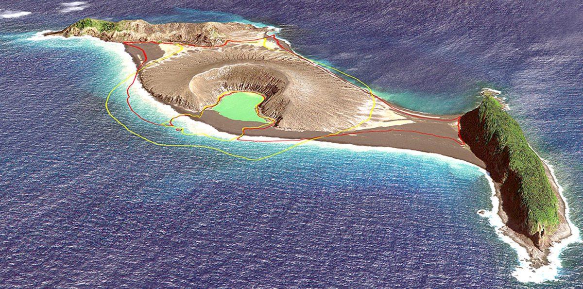
The island is shown below. The cone formed in an eruption in 2015, which filled in the hole between the two parts. It is now gone. The two parts, the two islands that existed before 2015, are called Hunga-Ha’apai and Hunga Tonga. They are ridges a little over 100 meter high and 1.5 kilometers long, with vegetation.

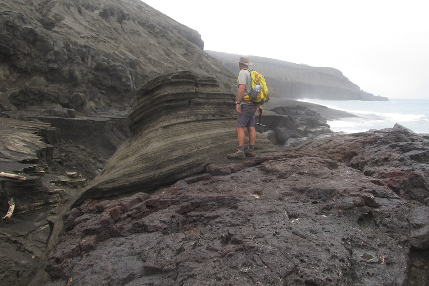
Shane Cronin studied the island after the 2015 eruption. The photo above is from him (taken from https://www.abc.net.au/news/2022-01-16/tonga-volcano-could-erupt-again-says-expert-who-visited-the-site/100759390). It shows the rough eroded side of the ridge, but also a block with thin layers, which originally would have been horizontal before the block fell down. This looks like deposits from pyroclastic flows or base flows. This volcano has done big explosions before.
The map shows two further, very small islands south of Hunga Tonga. Just like the two ends of Hunga Tonga, they show a ridge-like appearance. It is tempting to draw a circle connecting the three ridges, perhaps a remnant of an old crater, 3 kilometers in diameter. Bathymetry done after the 2015 eruption by Shane Cronin confirms the general idea: it shows a deep hole within this ring, partly filled in by the 2015 cone.

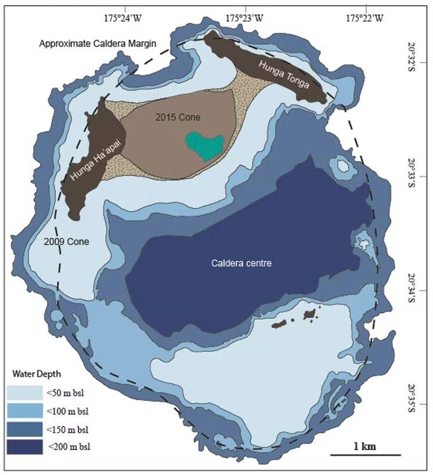
The small islands are seen to be the inner edge of a more extended plateau. The authors interpret this as a caldera with a size given by the outer edge of the plateau. (It had already been suggested to be a caldera in 1972, but this study confirmed it.) I would have taken the inner edge as the size, and go for the smaller caldera; the outer edge is the erosion of the submarine mountain which might even date to the time of lower sea level. There are two underwater domes on the eastern part of the ring which fit this smaller ring. But this doesn’t change the basic idea: this is a volcano which went caldera, and the eruptions are now on the ring fault. The 2009 and 1988 eruption were on the western part of the ring, and the islets on the southern ring erupted in 1912 and 1937.

Source: Cronin, https://eos.org/science-updates/new-volcanic-island-unveils-explosive-past
How big is the volcano? It rises from the sea floor almost 2 kilometers down, and it 20 kilometers wide (from the article by Shane Cronin). There are echoes of Iwo jima here. There is a kraken here.
How old is it? The islands were ‘discovered’ in 1616 when the first Europeans visited them. Locals, of course, knew of them as the ‘shaking islands’, suggesting frequent earthquakes. Carbon dating of deposits show that a large eruption happened sometime between 1000 and 1200. This eruption may also be the origin of deposits on other islands in the archipelago. Whether this was the eruption that formed the caldera is not known. More likely is perhaps that the ring is older, but that large eruptions similar to Jan 15 continue to happen inside the old caldera whenever water comes in touch with magma. Cronin finds that this happens about once per millennium. This makes yesterday’s event a millennium eruption, both because it is the largest volcanic explosion in this millennium so far and because it does this once per thousand years.
The trench

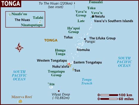
Tonga is well known for its shaking. It regularly features on earthquake maps. A look at the map shows, from right to left, the deep Pacific plate, the subduction trench, Tonga just beyond this trench, and a line of volcanoes 50 kilometers further, forming a volcanic arc. The trench is called the Tonga trench. It runs all the way to New Zealand where it is called the Kermadec trench. The wide ridge on which Tonga lies is pushed up by the subducting Pacific plate. There are frequent earthquakes when the connection gives way. The volcanic arc is a bit further, where the subducting plate becomes deep enough to generate some melt. The molten rock percolates up. This offset between larger islands and volcanic mounts is common, also seen in Fukutuko-Oka-No-Ba eruption
This part of the trench is particularly active, and there are many submarine volcanoes. Hunga Tonga is far from alone. Other islands in this arc are Fonuafo’ou, Tofua (with a large caldera), the steep kilometer-tall, steep cone of Kao, and the non-paradise Late (pronounced la-tay) island.
The eruption
The current eruption cycle began on 20 December 2021 with a significant explosion. The eruption continued for another week, but the ejecta now added to the island rather than destroying it. The surface area increased. The activity continued at low level, with steam clouds but no ash. But it resumed on January 14 with a large explosion. We don’t know how large it was, but ash reached 20 kilometers high, suggesting VEI 4.
The Planet images (https://twitter.com/tanyaofmars/status/1482426851226230784) show the changes over this time, from before the eruption (November), the steam cloud of 7January, to the aftermath of the Jan 14 explosion 2 hours before it blew up completely. Note that the explosion of December was not at the cone but 200 meters northeast, and had destroyed most of the old cone: only the western crater rim survived.

The big event now followed, just before sunset on January 15 (4:15 UT). There were two (perhaps three) explosions in quick succession. The cloud now reached 30 kilometers and stones fell down on Tonga, 60 kilometers away. There are spectacular images available which I won’t repeat here. Instead, the less impressive but more illustrative weather satellite below shows the rapid dust cloud, surrounded by a pressure wave. The pressure (wind) wave traveled at 200 km/h.
The explosion caused a blackout at Tonga, perhaps because of ash interfering with the generators. The islands of the archipelago are reportedly covered in ash, perhaps a few centimeters deep, looking like a lunar landscape. There was a tsunami which damaged the low lying islands – how much damage there is is not known yet as of time of writing, as communications are still down. The tsunami was not high, perhaps 1 meter, but that can still be destructive. Surprisingly, the tsunami traveled across the Pacific, still at 1 meter when reaching Japan, and perhaps half that in North America. It caused minor flooding and shore damage. More seriously, two people died in Peru when they were overtaken by the wave.
Source: wikipedia
The tsunami has done local damage. This https://twitter.com/DrAndreasS/status/1482500248702533634“>image shows how two islands or Tonga have disappeared. This group of 6 islands (four of which are shown) lies about 50 km east of Hunga Tonga. Tau is about 200 meters in size, Nuku about 500 meters. This makes one wonder about the direction of the tsunami. Area to the south and west were less affected, areas north and east much more, extending all the way to Peru. The tsunami waves were mainly directed north and east, luckily away from the populated areas of Tonga and Fiji.

Sentinel radar images taken yesterday show only the two ridges of the original island. The ridge of Hunga-Ha’apai has survived, although its northernmost tip is gone. But only a small central fragment of ridge of Hunga Tonga remains. Everything else is gone, destroyed either by the explosion or by the tsunami that followed. A large raft of debris (pumice) is drifting to the south. The two islands on the southern caldera rim may also have gone. There is some real estate of the world that will be never be seen again. Note that the west island survived much better than the east island, even the easter ridge was taller and had obviously an older large eruption. Wqs this because of the off-centre eruption, or because of the tsunami? Did this ridge direct the tsunami away from Tonga, and so prevented a catastrophe?

Aftermath
How large was the eruption? This is normally classified on the VEI scale. It measures tephra volume, and is designed only for explosive eruptions. The tephra forms by fragmenting the rock. It is much less dense than the rock and therefore larger: the tephra volume does not fit in the hole it came from. VEI-4 is between 0.1 and 1km3, VEI-5 from 1 to 10 km3 and VEI-6 from 10 to 100 km3. VEI-6 eruptions happen a few times per century. VEI-7’s are more rare, about once every 300 years. VEI-6 eruptions have a small impact on global climate, lasting 1 to a few years.
The height of the plume is a rough indicator of the eruption size. VEI-5 can have plumes 10-25 kilometers tall, and VEI-6 goes higher. But the plume height can be affected by many things and is only a rough indicator. At face value, it would put the Jan 15 eruption as VEI-6 (just) and the eruption of the previous day as VEI-5. In practice this may overstate the case.
The fact that two slivers survive puts a limit on the size of the eruption. The crater that formed must fit inside these slivers. That gives a diameter of 2 kilometers. Assuming a hole half as deep, the evacuated volume would be 4 km3. That is in dense rock equivalent. The tephra volume would be larger. Assuming the usual factor of 2.2 (which may be an overestimate for this case) gives a tephra volume of 9 km3, or a high-end VEI-5. It is hard to fit a VEI-6 into the hole, unless it is centred further south than the earlier eruptions in which case it cold be marginally higher. On the other hand, our numbers may overestimate the hole a bit.
These numbers suggest this may have been the fifth largest eruption since the start of the 20th century, after Novarupta 1912 (25 km3), Santa Maria in 1902 (15 km3), Pinatubo 1991 (12 km3) and Quizapú in 1932 (9 km3). (Volumes in tephra, estimated at 2.2 times the dense rock of the hole. (Which is called ‘DRE’ for dense rock equivalent.)
The numbers are however subject to change, and in all likelihood we will never have an accurate size of the eruption as almost all the ash will have fallen into the sea. But Hunga Tonga 2022 was likely a large VEI-5.
Marine eruptions
Eruptions like Hunga Tonga are surprisingly easy to miss. This particular volcano happened to be monitored because it was near population, and of course it was seen by satellites. The most recent similar eruption was that of fukutuko-oka-no-ba, but this was smaller. The most recent comparable eruption was a VEI-5 eruption on October 31 1924, at Iriomote jima, a Japanese island 200 kilometers off the coast of Taiwan. This eruption was completely missed – until a long trail of rhyolitic pumice appeared floating along Japan. The pumice has an estimated volume of 1 km3. We don’t know how much larger this eruption was. The volcano that produced it is 200 meters below sea.
An older case that of Graham Island, off Sicily, in August 1831. It produced less ash, but brilliant sunsets across the Atlantic ocean.
The current eruption is large enough to have a minor effect on global temperatures. The size would suggest a cooling of 0.1-0.2C. However, this is strongly dependent on how sulphur there was. We know there was some, based on reported smells (60 kilometers away!), but not how much. However, Hunga Tonga is at the southern edge of the tropics, and the impact may not easily spread the the northern hemisphere. People in the southern hemisphere may get some colourful sunsets though. Teenager, if your mobile phone takes on a funny red shade, don’t ask for a new one. Look up, and see what your phone screen is reflecting. A silver lining.
Albert Zijlstra, January 2022
(For another overview, see https://www.severe-weather.eu/news/tonga-volcano-massive-eruption-explosion-stratosphere-usa-tsunami-shockwave-fa/)


Meanwhile thanks for the extremely fast shipped, first post!
I just finished reading. I’d also go with a 30 km cloud height.
I just read that there was in 1924 a submarine eruption near Japan with a VEI 5. I will send a link.
https://www.data.jma.go.jp/svd/vois/data/tokyo/STOCK/souran_eng/volcanoes/099_submarine_volcano_nne_of_iriomotejima.pdf
It was mentioned in the previous post as the most recent similar eruption: Iriomote jima, 31 Oct 1924. It produced 1 km3 of pumice, so not quite like Hunga Tonga
SALT?
Dear all, thank you for the insight and the fine analysis.
Talking about the chemistry of such an explosion, what happened to the salt?
Have these tons of salt (millions, probably) been sent up with the steam and the ash, forming a huge cloud carrying salty rain?
I don’t think that this is a too crazy of an idea.
As opposed to gentle evaporation where the salt stays at the ground, the salt is likely to have been blasted in the air too, especially if even insoluble ash has been blasted into the air too.
So yes, there likely will have been some salty rain, if it has rained somewhere in the first place, or tiny grains of salt and ash falling from the sky, at least within reasonable vicinity to the volcano.
Which brings us to another question, what happened to the plume while/after the detonation? There where some non-volcanic thunderstorms at the satellite picture I saw, but they obviously had clean air in them as usual. But what about the salty/ashy plume? Maybe got incorporated in a later non-volcanic thunderstorm?
What about the salt in the water?
Dear all, thank you for the insight and the fine analysis.
Talking about the chemistry of such an explosion, what happened to the salt?
Have these tons of salt (millions, probably) been sent up with the steam and the ash, forming a huge cloud carrying salty rain?