
Sometimes, a volcano is nothing more than a hole in the ground. There are beautiful, though deeply eroded, cone volcanoes around Taal: Mount Banahaw, Mount Mariveles, Mount Natib – especially the latter also has a large caldera. But Taal is not like that. It is a lake, with only a little cone sticking out. The BBC thought it was worthy of the label ‘small’. But that is deceptive. The lake itself is the sign. It is the scar of a series of large eruptions which collapsed the land. The volcano never really recovered. The old crater rim is still visible on the photo above (Christina H Koch, on board the ISS). Its immensity is clear when compared to other, nearby volcanoes. Only Natib comes close, with its 40 km2 caldera. Taal caldera (actually a double caldera) is almost 500 km2, though.
This may sound worrying. With a caldera this size, we could be in VEI 8 territory. (We are not in Toba land though. That caldera is 5 times larger.) But it isn’t like that and it has never done a VEI 8, although it may have reached VEI 7. Taal’s enormous caldera formed in collapse rather than expulsion. The content went somewhere, but only a small fraction ended up in the sky. Probably. Still, this is not a volcano to take lightly, not even by the BBC. Luckily, stupendous calderas are invariably old. It happened a long time ago.
But not quite. One (and only one) of the major eruptions has been dated. It happened 5380 +- 170 BP (radiocarbon years – they differ slightly from calendar years). That is not quite yesterday, but almost yesteryear. This volcano is perhaps not as safe as we would like.
Geology

It is always worth looking at a map. A map beats even the best TomTom satnav, if you want to understand the lie of the land. The land of the Philippines is clearly rather sea-rich. The country has over 7000 islands! That doesn’t happen by accident: this is a region with some active geology. After all, all deep sea islands are volcanic in origin, and all mountain chains indicate careless driving by plates. Manila, the capital, is on the northernmost of the major islands, between a bay and a funny looking lake, called Laguna Bay. The lake south of Manila is Taal. It becomes worrying when you realize that the middle of the three fingers of Laguna Bay is a 200 km2 caldera. Taal caldera is 50 km south. Pinatubo is 100 km northwest of Manila and Mayon is 250 km southeast. Was this really the wisest place to locate the capital?
(In addition, the West Valley Fault runs through Manila towards Taal: this fault may be primed for an M7 earthquake. I just mention it.)
The sea also hides secrets. The Philippines are squeezed between two plates. On the west side is the Sunda plate, bordered by the Manila Trench, and on the east is the Philippine sea plate, bordered by the Philippine trench the 3rd deepest trench in the world. Both are subducting underneath the Philippines. The Manila trench feeds Pinatubo, and the Philippine trench feeds Mayon. The Philippines are sheared by the conflicting motions: a left-lateral fault zone runs along the entire country. In Luzon, the island with Manilla, the subduction is dominated by the Manila Trench. The Philippine plate has only recently started subducting this far north, and it is still shallow. Further south its subduction is better developed.

Taal Volcanics
Taal is part of the Southwest Luzon volcanic field, fed by the Manila trench subduction. It has over 200 volcanoes, some younger than 10,000 years. There are so many because part of the field is monogenetic. The most famous of these are the seven lakes of San Pablo, all seven maars. Mount Banahaw, 50 km southeast of Manilla, has erupted twice since 1600; its 1730 eruption ruptured its crater lake, causing a flood that destroyed a town. It is not all Taal here.
This volcanic field is related to The Macolod Corridor is a 40 km wide rift zone, running southwest to northeast. It is about 1 million years old. The volcanoes it has produced are basaltic. Taal is affected by this rift zone: the southwestern part of the lake shows a graben with this alignment.


But this is not the only rift zone in the area. A second one runs from Taal northwards, in the direction north-northwest to south-southeast. This is an extensional zone, and is less dominant. Very little has been published on it – nowadays it is most obvious from the alignment of the roads in this location! It has been suggested that Taal forms the intersection of these two rift zones.
The volcanoes are caused by a combination of the rift and the subduction zone below. The magma is formed in the subduction layer: it is oceanic basalt, with the addition of melt from several kilometers of sediment that accumulated on this oceanic floor. There is no evidence of crustal melt, suggesting that the rift makes it easier for the magma to percolate up but does not generate melt itself.
A magma chamber exists 1 km below Volcano Island. A second layer of magma is found at 7-10 km depth. Eruptions are caused by magma migrating from the deeper to the shallow reservoir, although not all such intrusions cause eruptions.
Eruptions
34 eruptions have been reported from Taal since 1572. This included 2020. But only 25 of those are confirmed. The 1754 event may have been the largest of the historical eruptions, and may have reached VEI 5. A few events have been plinian, but the most common type are phreato-magmatic explosions. This after all is a thoroughly wetted area! All eruptions have been on or next to Volcano Island. There are some eye witness reports that sound like fissure eruptions. And the eruption have come from all four corners of the island: the central crater does not have a monopoly on eruptions. From 1572 to 1645 and again from 1749 to 1911, eruptions came from the central crater. Between 1707 and 1731 the eruptions came from various craters on the outer flanks (the 1716 and 1731 eruptions occurred in the lake), as did the 1965 and 1977 events. The 2020 explosion was again from the main crater. Eruptions tend not to move from inside to outside the crater, or the other way, within the same eruption. But this may be a rule that is there to be broken!
The change from one mode to the other coincides with a dormant phase lasting typically 50 years (the quiet time between 1731 and 1749 was only 18 years). During a mode, eruptions are typically 5 to 15 years apart. But after the large 1754 eruption, there was half a century of quiescence and another 50 years of minor eruptions only. The large 1911 explosion was also followed by 50 years of solitude.
The largest of the historical eruptions was that from 1754. The eruptions started on May 15th and finally ceased December 2. Within this period were a few quieter phases, lasting a few weeks to a month. October was eruption-free. But there were powerful explosions throughout the 7 months. The sudden explosion on May 15th send a plume estimated at 40 km height, and caused a pyroclastic flow that destroyed a village 8 km northwest. After this, activity became just ‘furious’ with explosions ejecting stones and mud, volcanic lightning and tephra – an ordinary eruption. An intense explosion on Nov 15 causes boulders to fall into the lake, causing huge waves. November 28 was bigger, and now the volcanic tsunami was large enough to cause flooding. The biggest explosion was a day later, with complete darkness and houses collapsing under the weight of the ash.
The pyroclastic flows or base surges reached most places on the lake. To the west, the maximum distance was thought to be 16 km. However, mapping of the deposits suggests it came even further in-land and reached both the Tagaytay ridge and the coast. The dashed line on the plot shows the suspected extent. The ash reached 2 meters thick on Volcano Island and 1.1 meters on the shore. Even the region of Lemery received 10 cm.

A few days later a typhoon came and caused numerous landslides. It never rains but pours. The tephra reached Manila.
This was the worst eruption in recorded history. It is now classified as VEI 5. But there were other damaging eruptions. As an example, the 1911 eruption caused tsunami waves 3 meters high on the shores which did significant damage, and the surge reached 9 kilometers distance.
Below is the list of known eruptions. Ones in italics are not confirmed. Red dates correspond to eruptions from the main crater. The others are from the flanks and lake. The groupings into A-D are from Delos Reyes et al., Earth-Science Reviews 177, 565 (2018). Much of the information in this post is taken from that paper. (“A synthesis and review of historical eruptions at Taal Volcano, SouthernLuzon, Philippine” is the promising title – sadly the paper is locked away and largely unread behind a paywall). On their scheme, 2020 would count as the start of sequence ‘E’.
Note added: Mike K. has pointed out that the paper is no longer paywalled and is now freely accessible at https://www.sciencedirect.com/science/article/pii/S0012825216304068

Most eruptions affected Volcano island only and provided a spectacle to the on-looker but no danger. Some affected the lake, and some went beyond and did endanger people living around the lake. Taal has been responsible for around 1500 deaths in recorded history.
The Ancients
Surprisingly little is known about the older eruptions of Taal, and the formation of its caldera. That is at least in part due to the climate. Tephra layers are rapidly removed or decomposed by the tropical rains. But we know there have been eruptions much larger than those of the past 500 years. The existence of Lake Taal is telling. The prehistory is the tale of Lake Taal.
There are four main debris layers around Taal caldera, with scoria, ignimbrites and pyroclastic flows. The youngest pyroclastic flow is the only one that has been dated. It formed between 5380 and 6830 BP (radiocarbon dates). The volume of this eruption is estimated at 50 km3, or a large VEI 6. This flow is young enough that Taal is likely to have looked similar to what it is now. It was a hot, gas-rich, concentrated pyroclastic flow. The recent flow is centred on the lake, but not on Volcano Island. There may have been a different eruption center at that time, which was destroyed in the eruption.
The other flows are older but not well dated. The Taal Tuff is not older than 300,000 years, ignimbrites are 100,000 to 500,000 years old and pyroclastic flows are less than 140,000 years. This has been interpreted as that all four are less than 140,000 years old. A sea core has shown 16 large explosive events over the past half a million years coming from the Macolod Corridor, similar to and including the one 6000 years ago. Over this time, the eruptions have slowly become focussed on Taal. Taal Lake consists of at least two separate calderas, already showing more than one major event.
The first three of the major Taal eruptions produced andesitic to dacitic ignimbrites. The most recent one ejected basaltic andesite. This may represent evolution of the volcano. An optimistic interpretation is that it is not as explosive nowadays as it was 100,000 years ago!
An important question is whether these events reached over the 600-meter high Tagaytay ridge and made their way towards Manila. Did they reach? The Taal ignimbrite plain extend northwest to Manila Bay, so it did get close. Manila is build on several ignimbrite layers, up to 10 meters thick. Their origin is not known but Taal is one of the two main suspects.
This is the background to the recent eruption from Taal volcano. On the scale of historic eruptions, this event was not insignificant but not major. It may however herald a time of more frequent eruptions, now that the focus has shifted back to Main Crater. Main Crater has been quiet for more than century. This is unlikely to be repeated.
Taal has proven plenty of hazards: tsunamis, pyroclastic deposits, thick ash, sulfuric gasses. It is clear that Volcano Island is not suitable for habitation. After every cleansing, over time people move back to the island. This is a recipe for disaster. The shores are also dangerous but here the danger is perhaps more manageable. All houses and other structures should be able to handle tsunamis of at least 3 meters high (5 meters preferred) and able to carry a weight of 1 meter of ash. A tsunami warning system is needed. An evacuation plan should allow for rapid movement of people, including every location between Lake Taal and the coast: this may require new escape roads.
And from now on, Taal tourism may need to adopt a ‘look but don’t touch’ approach. No more swimming in its acid lake. It would be wise to remember White Island.
Albert, January 2020


Thanks Albert !!! Very interesting and a exellent write….
Excellent reading, thank you Albert!
The fact that more recent eruptions are basaltic may not mean much as this pattern may have occurred during the intervals between prehistoric large eruptions, a lot of smaller stuff can happen 5000 years and then get buried by a VEI 6 or 7?
I did say it was optimistic.. But volcanoes do evolve over 100,000 years and old Taal was not the same as new Taal. The past is not always the ultimate guide.
I do explicitly not want to imply anything for the situation at hand. But this is a very general problem, no? Very large eruptions are both so rare that they never have happened more than once for a single volcano in modern times, and destructive, so that forensics of what happened before the “big one” is limited…
Indeed. We don’t have any data on the run-up to a VEI 7 so have no idea what to expect! If you are interested, we once tried to find out how Krakatau behaved before its big eruption. It was an epic task and inconclusive result – we only fund indications for inflation and for the water sources drying up. Feel free to read if you have a spare week!
https://www.volcanocafe.org/prelude-to-krakatau-part-one/
Thanks! For sure will read on the next train ride!
Keep in mind – just because a volcano has erupted a certain type of magma (say andesite) recently does not mean it ONLY erupts that type of magma.
Bimodality is very common in volcanoes, especially the bigger volcanoes with a caldera history. As I mentioned in the previous post, volcanoes frequently have uneruptible magma, which would be much more viscous. Due to the fact that this magma is crystallized typically, it doesn’t normally erupt. The risk is when that magma gets heated up by fresh basalt injections from depth. Those injections can turn viscous uneruptible magma into viscous and explosive eruptible magma if heated enough. This should hopefully give everyone here an idea on how a volcano that normally erupts basalt can also on rare occasion create large rhyolitic eruptions (we see this in Iceland for instance).
The creation of the more viscous magma in a volcano typically comes from either fractionation or crustal melting.
Bimodality is indeed very frequent. A nice example is Rabaul, its vents Tavurvur and Vulcan are located in opposite sides of the caldera, Tavurvur taps into andesite while Vulcan taps into dacite, the result is that eruptions from the later one are generally more powerfull.
However in recent times Taal has not shown any signs of bimodality, true that it is not very well studied but if what you are implying is the posibility of VEI6-7 eruptions then a small amount of silicic melt is not going to avail. It cannot be formed rapidly either, processes such as fractionation or crustal melting are not rapid they work over very long timescales of usually centuries to produce noticeable changes.
Do you think Taal could be hiding somewhere so much silicic magma and not erupting any? In my opinion this is very unlikely, if anything the more silicic melt should have accumulated at the summit being more buoyant material and as such it should have come out in some historic eruption. But there are still a lot of unknowns regarding Taal I guess.
We don’t know how much silicic magma Taal is or isn’t hiding. There is surely some in there, the question is how much is there, and how much can be made eruptible by a basalt injection? As for it not coming out, I would say that depends on the nature of the eruption itself.
I agree, anything silicic is not high in the likelihood scale, but we simply don’t now the contents of the magma chamber. Keep in mind, you don’t need Rhyolite or Dacite to have large explosive eruptions. You can get large eruptions even with basalt, but they’re very rare of course.
I think a great view on this type of behavior is the Okataina eruption in New Zealand in the 1800’s. We know that the north island is one of the biggest areas of silicic volcanism in the world, but it’s all triggered by basalt and crustal extension. That same type of example can be roughly applied here.
So what happened at Okataina? It was a large VEI-5 eruption, but it was almost purely basalt. So getting to your question, why was there not any silicic magma erupted then? It’s unlikely that there simply was zero silicic magma around during Okataina’s eruption, so I would wager that the hot basalt injection (which adds some pressure on its own) punched through the rhyolitic crust and erupted to the surface. Since the basalt was able to escape to the surface so quickly, it did not cause any notable reinvigoration of the rhyolite layer, and thus the potential for reheating and remobilization of that magma was drastically decreased. Had that basalt continued to be injected below the rhyolite layer without escaping, we may have seen a very different scenario.
So that’s basically my scenario for how we would *potentially* get something of a more explosive nature at Taal. You would need a continued ongoing intrusion combined with no major releases of the magma in the system. Considering the fact that we already saw a small release of fresh magma, I would say this scenario is unlikely since pressure would probably just get released from what seems to be a semi-open system right now. But that’s not absolute, and we are seeing ongoing intrusion right now without any emissions, so who knows.
Basaltic explosive eruptions do get to a confirmed VEI5, a very voluminous eruption like Lakagigar turned into tephra due to water interaction in a situation where water doesn’t run out (so an extremely rare scenario) could theoretically go into VEI6 and a VEI7 doesn’t really seem possible given the current active volcanoes.
About the intrusion it seems to have removed magma from Taal (which is what would be expected from a dyke), the Volcano Island has subsided, houses and trees are underwater in the north coast, this can be explained by the island sinking over a deflating magma body, so while the scenario you describe I guess could be possible in the future, right now it doesn’t look like it is the case. The intrusion also seems over, a decent dyke produces earthquakes of M3-M4 and a massive one of M5, the fact that those have been mostly absent during the last few days points to the intrusion being paused or finished altogether.
Yet PHIVOLCS seem to be saying the opposite – at least as quoted they say the magma is fresh into the system and trying to get to the island. They have explicitly said one side is sinking because it is being pushed up and tilted from the intrusion. They also casually mentioned other “magma chambers” existing around the lake which I don’t think they’d said before.
I’m not expressing a view here just that’s how they seem happy to be quoted.
Basaltic VEI-8 eruptions have actually occurred in the very very distant past. It’s an obscure eruption millions of years ago, but they are at least possible based on documented evidence. And basaltic andesite (which has historically erupted at Taal) isn’t that far off from the current basalt.
Beyond that, look at Ambrym and Masaya as other potentially similar volcanoes are good examples of what can happen here.
**And just to clarify**, I’m not suggesting we’re about to see a catastrophic eruption. Just trying to be realistic about the low probability possibilities. People often tend to write these items off as being impossible, which isn’t really accurate, and ignores the structure of the system as a whole.
That has always been an interest of mine so I have investigated about both Masaya and Ambrym.
In Masaya I have only found VEI5 eruptions (like the Masaya Tuff, or the Triple Layer). True I don’t know much about the older Las Sierras shield.
In Ambrym so far perhaps a few VEI4 during the 20th century, the prehistoric eruptions are not studied. It is true that some scientist proposed the 12km caldera of Ambrym formed in a large explosive eruption but that has later been criticized, most likely he just interpreted deposits of many different eruptions as belonging to the same event. The north part of the ring fault had also started to slip during the dyke intrusion of 2018 which means it came really close to collapsing as a whole. This points to the likely origin of the caldera: An eruption/eruptions or large intrusions in its east rift zone.
Basaltic VEI8 sounds interesting, but it is just an obscure past I guess.
A VEI 8 basaltic eruption is Probaly What the huge Flood basalt flows where
CAMP and Siberian Traps
produced flows with volumes of many many 1000 s of km3 erupting from fissures 100 s of km long
There is nothing to suggest that this volcano has had a very large eruption for thousands if years but that is plenty of time to build up a large supply if evolved magma , the size if this complex would have to suggest the possibility of tens of cubic km of thus magma minimum. What is the chance that a lot of this deformation, tilting etc is due to the mobilisation of viscous magma, that does not necessarily mean thus magma will erupt anytime soon. The mistake a lot make is to think that because something happened thousand of years ago that it is ancient, it us only ancient in human terms for earth processes it is yesterday.
Phivolcs published an image of the steaming fissures in Taal crater:
Amazing how something can change in three weeks.
Again, again and again – pretty easy and good read for me as non-reader – THX for keeping me working on my reading skills!
A question which popped up – how is this VEI (and DRE?) accounting in all this water-vulcano-eruptions like they should have happened in the Philippine past more than once and which are hidden in the ice-cores (?)…
Something like this new Mayotte-Mountain, which I don’t can compare to surface eruptions:
https://en.wikipedia.org/wiki/11_November_2018_Mayotte_seismic_event?wprov=sfla1
Never paid much attention to Taal before, but after reading these posts, some other research, and just seeing the pictures, I agree with what someone else wrote a few posts back, this one gives me the heebie-jeebies.
Most volcanoes are some combination of majestic, spectacular and/or awe inspiring. This one is none of those things. It is more like the volcano equivalent of a den of a million angry black mambas, rattlesnakes and spitting cobras.
Until this settles down, the best option is to just back away slowly, get in the car, and drive to the airport.
On top of the local threat, if this thing pops soon with any size, the plume will head straight north into the jet stream.
It seems I have another convert to the “don’t be there” philosophy…:D
Good read about the instant response of the government after the 1st eruption. Written by a Dutch guy who lived directly at lake taal. Warning was way too late. I have been there, too when it erupted and can confirm that the warning sms from the government came around 4 hours delayed (while electricity/internet failed and there was zero information): https://anderslundgrenblog.wordpress.com/2020/01/23/how-the-philippines-provincial-and-local-government-really-acted-and-still-acts-towards-the-victims-of-taalvolcano-eruption-taaleruption2020-volcanotaal-taalvolcanoeruption-volcano-taal-man/amp/
I think a lot of that blog post can be summed up as, “Waah! Waah! I’m stupid and haven’t got a clue about volcanoes because I can’t be bothered.”
He lived on Volcano Island. He is Dutch and thus he has a choice in the matter. It’s not like he was born in the area. He chose to move to Volcano Island. He chose that place without checking properly what the implications of living there are.
He had no evacuation plan. He just sat there whilst a dangerous volcano was erupting nearby. That’s all on him.
There are legitimate criticisms of the government response, but whinging about him being an intellectual vegetable in his personal response to the eruption isn’t one of them!
He did not live on Volcano Island. He lived near the lake. That invalidates most of your comment.
He lived in Talisay which is away from the Volcano Island, outside the permanent hazard zone.
Not everyone is obliged to be knowledgeable about volcanoes, though it is true it would be good to be aware about the hazards when you live next to Taal.
It is however PHIVOLCS responsability to inform the people about them. It is fundamental for people within a hazard area to be informed on how to act during an eruption.
That the alarms were delayed by 4 hours is most concerning, if this eruption had been like 1965 then the base surge would have outpaced the alarms and people would have died…
OT – Hector, please check your emails
The recent eruption is one of the characteristic of Taal, unfortunately this character was not fully considered. Though its been months since the alert level where raised to 1, Philvocs did not predict that Taal is capable of such eruption from level 1 to 4 alert was raised in span of 2hours. On that day their instruments was not able to detect that Taal will go ballistic.
This is probably due to an old magma deposit that gets activated was very near on the surface.
I hope such eruption did not cause other large magma deposit to reenergize though instruments tells the continuing restiveness down under which could lead to a year of frequent minor eruption or a large one if it continue to hold off for months same as it did before.
It had been more than a century since the main crater had last erupted. That may explain some of the surprise at the speed of events. But there must have some precursor, one would expect, some indication of impending failure of containment?
Their is a video circulating on YouTube of tourists on horses fleeing the crater as they see streaming coming from where the eruption occured, possibly very little precursor as it started phreatic and then quickly progressed to erupting in situ magma, that source of eruptible magma now gone it is back to de gassing shallow magma?
OT: Are we building an outpost of TBO ??
N
The guide living on the permanent danger zone and people paying to venture into danger wad extremely lucky. Given his experience he immediately sense danger upon seing a smoke which is not there for the longest time shows that he knows well the danger on the crater that such smoke could always lead to a kind of explosion.
After Jan 12 explosion, there was an M5 quake coming from Tingloy/Mabini area and prior Jan 12 an M7 quake occurs on the same area sometime in 2018 or 2017, then in 2019 Taal show unrest. There is a potential that this area is where the chain reaction started though movement was not detected not until the recent eruption which might only be due to other factor that activated a shallow old deposit. In reverse the recent eruption may had lead to further reaction back to Tingloy/Mabini deposit and could lead to further unrest and potential for another eruption to see.
Can’t do a VEI on something that isn’t explosive. After all, that is what the ‘E’ stands for. The plume height is also not readily available for something deep under water. DRE is a different matter – this was probably quite a significant event, perhaps at the 1km3 level.
Hmm that makes me think of a knew theory for the lost vehicles in the Bermuda Triangle instead of Methanhydrates, vulcanic H2O/CO2/SO2 bubbles?!? Didn’t calculate it so fare (Don’t know how *ggg*) – or are they taken by the aliens?!? *rofl*
No one got a notice about the new “mountain” close to #Mayotte
What’s about flight MH370?!?
https://en.wikipedia.org/wiki/Bermuda_Triangle#Methane_hydrates
I strongly doubt that MH370 was brought down by methane hydrates half a world away from where it was.
For most of the year, the volcanoes in the Philippines are too far south for any but the very largest eruptions VEIs to create a record in the ice sheets.
Most of the year the tropopause over the Phillipines is at 18km or so. It takes a very bouyant plume to elevate the aerosol high enough to be transported in upper levels of the atmosphere.
Because it happened in June, even Pinitubo barely created a blip in the ice record. Same is true for all the equatorial volcanoes. Only the biggest show up in the ice. The majority of the mass from the plumes from the rest of the eruptions just get chewed up within a few weeks weeks in the hot humid equatorial region.
That is what makes Taal even more hazerdous for the next few weeks. With the winter jet stream much farther south, right now, it would only take a 8km or 9km plume to make a real mess of things because it would head straight into the jet stream.
The fissure on the crater floor is particularly creepy. Seems to follow the angle of the corridor in general.
That would be sort of typical for the overall corridor then wouldn’t it?
craaaaack
https://www.gmanetwork.com/news/news/regions/723384/taal-spews-thick-steam-anew-number-of-quakes-rises/story/
Taal is now waking up again
Magma is nearing the surface
Tagolog is one of the principal languages of the Philippines. (Other dialects have their concentration areas). Tagolog is derived from an Australasian/polynesian background. Based on how I heard a newscaster pronounced it, and confirmed by a nurse I talked to this evening that was raised on Luzon, the correct pronunciation is “Ta – All”. It seems each letter gets pronounced like some other polynesian languages.
“confirmed by a nurse I talked to this evening ” Hope You are in good health?
So if we are to treat it like Hawaiian names such as Pu’u O’o it would be written Ta’al to emphasise that it is two syllables and not just one.
Probably.
I’m not linguist.
Be careful to separate the syllables, it is not the same thing as the pronunciation of all the letters. (as in Tahitian)
I’m not linguist either, only bars worldwide.
Ref the nurse, yes I’m fine. ER doc was worried about some enzyme levels my wife had. Official word from cardiology – Not a Heart Attack. Now they are trying to figure out just what is going on.
https://www.gmanetwork.com/news/news/regions/723384/taal-spews-thick-steam-anew-number-of-quakes-rises/story/
Tall is charging up now again!
Lava fountains may start in the crater soon
https://i.stuff.co.nz/national/118963468/lava-visible-on-whakaariwhite-island-but-eruption-unlikely
3 small lava domes are now visible in White Island
Magma surfaced
Ok that is significant , that could possibly be dacite dome building and so this volcano could potentially become more explosive or just go to an effusive eruption style?
The 2012 dome never grew any big
Is There signs that more gas poor dacite is on its way? any inflation over Whakaari?
Not if you go by the attitude of Geonet, seriously those guys downplay everything, the whole tourist tragedy could possibly been avoid with a more forthright attitude. I don’t know what they would do if okataina or similar was acting like taal , they would be one of the worst in the world in my opinion, kind of arrogant and dismissive of everything, either that or just ignorant.
The December tourist tragedy was possibly a collapse of a small lava dome, causing a burst of hot ash and debris along the crater floor?
Any webcameras so I can see the Whakaari domes?
To monitor if they grow over the comming weeks
Here you go this is the crater floor cam, others are available as well.
https://www.geonet.org.nz/volcano/cameras/whiteislandcraterfloor
Or crater rim which is a bit dirty at the moment.
https://www.geonet.org.nz/volcano/cameras/whiteislandcraterrim
Its glowing! Then it means that the dome is still growing
If you see a ‘glow’ when the webcam is in night vision mode, it doesn’t necessarily mean that there is actual incandescence. Hot steam is usually enough to produce that ‘glow’ since the night mode of the camera is sensitive to infrared. Yes, the lava domes could be growing, but it could also just be hot steam rising.
White island always streaming and it does not glow in the camera’s and the glow when it was there before was a lot smaller than now.
This magma is extremely viscous
Hawaii is like water in comparsion
https://m.youtube.com/watch?v=eQ-JKf-iQpg I dont know any other basaltic magma Thats as fluid as that!
Whats the viscosity of Whakaaris Dacites?
In PA.S ?
I know that white Island haves very high viscosity.. and that makes it extremely dangerous if its high gas content
Should be something in here.
https://academic.oup.com/petrology/article/41/6/867/1587273
Highest silica content that I read was 63.4% that was for effusive lava from the central cone.
https://m.youtube.com/watch?v=jLLYcuZzkfc
Etna is now also erupting constantly non stop! Been doing that since september.
Erupting a rather cold viscous basalt
Strombolian viscosity
There is a large area that has moved, so something is causing it to move and by what they are saying it is magma, so that means heat, so this started out as an eruption in the most recently active area and maybe is transitioning into a geothermal event, maybe more steaming areas could start to develop in other areas, i did see they mentioned magma in other areas around the complex, could it be likely that the original intrusion of magma has energised more dormant parts of the complex? Hopefully it will only be restless for a while and then gradually settle down again and maybe be relatively quiet for a few more decades, before the process repeats.
Gov’t to cut power, oil supply in Taal locked-down areas —DOE
“The Department of Energy (DOE) on Friday said it will temporarily suspend electricity services and cut the supply of petroleum in several areas placed on lockdown due to the ongoing activity of the Taal Volcano.
advertisement
At a press conference in Taguig City, Energy Undersecretary and spokesperson Felix Fuentebella said the DOE will implement the order of the National Disaster Risk Reduction and Management and Council (NDRRMC).
“We will implement the lockdown in the areas affected by the Taal Volcano eruption,” Fuentebella said.”
Getting serious
https://www.gmanetwork.com/news/money/content/723441/gov-t-to-cut-power-oil-supply-in-taal-locked-down-areas-doe/story/
Mac
No comment needed:
Although I ought not to be, I’m surprised one area of fissuring is down at the coast. I cna’t help but wonder what Taal will be like in a few thousand years.
Some light humour from xkcd
24 hours at VTAG
PHIVOLCS VTAG webcam early morning
Closer zoom from GMA
Saw this while watching the live stream….have not looked this up yet so don’t shoot me if it is not true!
“Taal lake has been around a Long long time, and the fish there were Salt water fish before evolving to fresh water. Totally one of a kind and can only be found in that lake.”
Mac
Yes prior to 1754 eruption, Taal Lake was saltwater, at sea level and the river channel much wider.
It is possible, of course, Taal Lake has oscillated between mostly salty and sort of fresh over a much longer time period.
This is a commonly quoted story. It seems to refer to one species in particular: the Taal sardine. It is the only freshwater sardine in the world, and occurs no one else. It likely survived the change to fresh water habitat after 1754, and became numerous as it had no competition. It is an important food source but listed as endangered due to overfishing. In any case, any species only occuring on a lake of an active volcano must have a limited life expectancy as species.
But sardines??? in Taal??
Sardines is a polar fish .. most happy in the cold fertile waters of the north?
Maybe they can live in the tropics too
I learns something new now
I’ve caught them on the Red Sea…
Remember Sardinia. The word is Greek which gives a hint where sardines may be found. Herring is a sardine to – it is a widespread family.
Brings back memories of breakfast in North East England. Mum would serve up roll-mop herrings…
I doubt many folks have them for breakfast these days!
Sardinella lemuru (Bali sardinella) is one of the Sardine species! They are pretty much worldwide in their various sub-species.
https://en.wikipedia.org/wiki/Sardine
Taal just had 2 small black ash eruptions following some low frequency tremor. Heven’t seen those for some days.
https://www.youtube.com/watch?v=g-xWJ8SEmGI
Around 01:30:00 on the top right graph.
Some change in the VTAG and VTSN since 19.00 UTC yesterday.
Magma movement signs (as I interpret them, no expert) are more regular now.
https://ibb.co/4fMp46L
content removed on request – admin
Dragon please remove the comment. 😪
Anak Krakatau has developed a double crater lake.
It is remarkable how quickly that island regrew itself.
I am not sure what type of camera they have on Taal but looks like a little glow coming from the Island. 10:36 EST
There is an intermittent steam plume. I am not sure what the light source is: it is new moon at the moment and there can’t be much artificial light on the island. The satellite image two days ago did show a possible heat source.
The camera in the upper right of the screen is a still feed that updates every 2 min. I just watched some activity on the seismograph they have at the top, and when the 2 min. update happened it got brighter.
I’ve spent a little time watching that camera today, and yes, there seems to be a dull glow inside the crater.
It reminded me of the early days of the Agung eruptions. I wonder how similar the magmas are in terms of viscosity etc ?
Neil
I am not sure if that camera is infrared, or some other type of “night” vision. Could be one of the columns of steam?
Mac
Ruminations…
Taal region has enough curves and cones to remind me of Naples’ coast. IIRC, the outer ‘Bay of Naples’, which sufficiently resembles a flooded mega-caldera to be real-scary, has been drilled and found to be ‘natural sediment & base-rock’ to great depth.
Gotta hope they drilled deep enough. My employers’ smart new production facility’s ground-works had to be re-thought when ‘full’ geo-technical survey found the initial ‘sparse’ survey’s bed-rock was actually ‘massive’ boulder clay. Literally chock-full of boulders bigger than cars. They’d drilled 2 metres of contiguous rock, called it a win.
( Had a lovely chat with full-survey’s drill crew. Politely skirting contractual NDA issues, we discussed local quirks of geology due mid-river fault’s alignment. Also, the glaciers which had pushed all that ‘massive’ debris *into* estuary from Irish Sea. This was same process which also put ‘recent’ sea-shells atop several Welsh hills, apparently supporting Noachian Flood… )
Taal alone has a weird resemblance to Santorini / Thera, now with ‘Nea’ growing in middle of that distressed caldera’s lagoon. Been a while, but yachties used to moor over Nea’s then-submerged vent, so the toxic plume would de-gunge their weedy hulls for free. No careening, scraping or toxic tin-paint required. But, don’t stay too long, lest your rudder pintle, prop and sacrificial anode dissolve, too. Or, in one sad case, your old keel-bolts fail…
Albert,
As per the article you just wrote – it’s very good.
However…you wrote this in your article:
(“A synthesis and review of historical eruptions at Taal Volcano, Southern Luzon, Philippine” is the promising title – sadly the paper is locked away and largely unread behind a paywall)
I’ve just dug up this article while searching on Google using the article’s title – https://www.sciencedirect.com/science/article/pii/S0012825216304068
This link above isn’t paywalled, nor do you have to register, and can thus be accessed freely. I honestly don’t know if that’s exactly what you were looking for, but I hope that’s the case.
They changed it from paywalled to open access only in the last week or so. I recall because I had to find a copy that had fallen off the back of a lorry earlier 🙂
Fantastic, thanks for pointing that out. The article is well worth reading. It was paywalled when I retrieved it (I did have legitimate access) but I am glad to see it has been made free to access. Geology does not yet have a culture of open access of research, unlike some other sciences. In my opinion, if research is paid for by governments, the outcomes should not be blocked. Most scientists would rather see their research read. It is only the publishers that gain by blocking access. We have to find a better system.
Use deleted, it usually bypasses the paywall for most papers. (This is legal by the way)
Please do not advertise pirate sites on VC.
Not it is NOT legal to bypass a paywall for a published paper. It is prima facie copyright infringement. It is also NOT fair use. It’s the scientific paper equivalent of using Napster to download illegally shared music 15 years ago.
I’ll keep using it anyway!
Well just prepare to be come after at some point for copyright infringement by one or more of the rightsholders. If they do come after you and the circumstances are as I get the impression that they are you would lose and you would deserve to lose any case.
Houses on the shore of Volcano Island. The Guardian had this as one of the images of the week.
https://www.theguardian.com/artanddesign/gallery/2020/jan/25/20-photographs-of-the-week#img-7
And that eruption was just a brief hiccup for that volcano.
PHIVOLCS managed to report a quake 52 minutes before it happened today
The tweet was sent at 1:08 AM local time
The quake is still listed at that time and hasn’t been corrected.
If there is some need for this Link : https://swift1.phivolcs.dost.gov.ph/seismograph/?fbclid=IwAR2txnC3CUObQkBIO64xf8fGTqgXKKl9zG3THPxgYQoYCExOs60NfuE-Vho
Good night…….
Sunday morning at Taal
Looking at the later pictures on the site (now the light is improving), it seems there are two more centres of steaming visible to the left of the main release. Not so vigorous.
Latest image
Am I seeing some steam plumes rising from the lake behind the island, or is it just my imagination?

Ringed in what I mean:
Holy Cow, this is one of the nicest sunset colours I’ve seen on a volcano webcam!
OT but that id drop dead gorgeous. You can smell the cool night air and hear the rainforest waking,
Latest image from VTGY
Must be pumping out high gas levels at the moment?
Any recent numbers on the tons of SO2?
SO2 was up to 419 tonnes on the last update I read earlier today. No idea if there is a newer update yet.
looks like a rift steaming just before the edge of the crater, could be a fire?
Mac
Alert level lowered from 4 to 3. Allegedly against the advice of PHIVOLCS
PHIVOLCS 8AM update has not appeared.
People allowed to return to many areas but advised to “consider their options” before returning as it “is still possible for volcano to erupt”.
That said in English at press conference moments ago.
Good, at least PHILVOCS gain confidence that Taal activity already entered into a more predictable state. A safe 1 day notice will be sufficient to evacuate again should they monitor magma movement is closing on the surface.
The hazard of volcanic eruption killing people is less than the hazard of typhoons and landslide in the Philippines so its understandable that its on the least priority. The government and community around Taal clearly shows lack of preparedness and plan how to respond during eruption which they must develop quickly due to potential continued unrest and eruption within days to years.
So who gets to compensate the survivors?
https://twitter.com/phivolcs_dost/status/1221246142630903809?s=19
Guys, what are you saying? Alert level lowered from 4 to 3. Evac zone lowered from 14km to 7km. Lots and lots of people going back right now. Need your opinion about that move. Politically motivated or legit move from Phivolcs? Thanks!
PHIVOLCS has released a new bulletin lowering Taal to Alert Level 3:
https://www.phivolcs.dost.gov.ph/index.php/taal-volcano-bulletin-menu/9698-taal-volcano-bulletin-26-january-2020-8-00-am-4
It seems to me that PHIVOLCS has good reasons to lower the level.
I refuse to answer on the grounds that I might offend the portly one.
(different volcano, different country)
The really good data has severe restrictions on it’s use. Nothing wrong with that, it is their data and their volcano. The most prudent option is to seek official sources for any decision making tools. And to then be a little paranoid that it could be worse. Not overly paranoid as the fearmongers want you to be, they get their pleasure from keeping people scared. And remember that “news” sites capitalize on that fear to keep you watching their programing.
My gut feel is that one day, some bureaucrat is gonna mess up and get people killed and not be held accountable for his decision.
In a nutshell, DON’T be manipulated, and DON’T be foolish. My mantra is always “Don’t be there,” but I’m far from an expert and I tend to err on the side of caution. If a potential base surge from a “hydro-volcano” is outside of your comfort zone, then by all means stay away from it.
Note: “Hydrovolcano” was a term coined on VolcanoCafe a few years ago. Specifically, it is a volcano with an overabundant access to water. They tend to be quite energetic when things go bad in a big way. Taal fits this category very well. That does not mean anything bad is going to happen. But it has the potential to be very nasty.. plus, it’s done so in the not too distant past.
Jogging is good for you… but jogging on a multi-lane highway with a lot of traffic is generally considered to be ill advised. That doesn’t mean you are going to be killed, but the potential for severe injury is there.
And to be more specific. My personal opinion is that the chance for a maar formation/explosion is the greatest hazard. PHILVOCS has as much as stated that a magmatic release from the various cracks is not expected. Remember that this is NOT Kilauea. Kilauea had a sizable quantity of very low viscosity magma in a lake high up on a mountain that then drained down into a rift system. Taal doesn’t have that.
GeoLurking
https://www.youtube.com/watch?v=eQ-JKf-iQpg
This is a very good video, showing just how extremely fluid Hawaiian lavas are!
Competely insanely fluid Kilauea is
and specialy at its summit
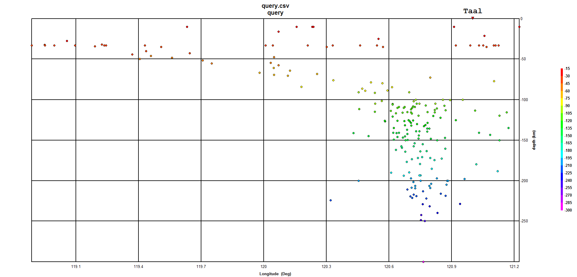
If there are two descending trenches on either side of the Philippines do they run into each other? Seems like nature wouldn’t favor that, but what do I know.
At great depth… definitely maybe.
If so, it’s is probably down deep below the 110km contour. (The “sweet spot” for dehydration melt formation.)
Opinion: If this is happening, it probably manifests itself as erratic subduction speeds between the two trenches. “Slab Pull” is the dominant theory behind plate movement and if they are folding and interfering with each other, this could affect how much pulling force they have on their respective plates.
Also, remember that the Palawan terrane is involved in this scenario. Being continental crust, it has a different buoyancy than the oceanic crust next to it. The Palawan terrane is going to lean more towards flat slab subduction as it goes under… unless it makes a mountain range instead. Mindoro island is on the leading edge of that crust shard. The interacting forces deep under the Philippines is probably quite a mess. We already know from the quake plot that the Benioff zone for at least one of the plates hangs almost straight down under the subduction zone. Another commentor noted that slab rollback is in play with that trench.
Quake data source: USGS. (30 year time window. Quakes within 60km of an E-W line through Taal towards the west.) Plot view looking North.
It is a tightrope. Two reasons to lower the warning level: Taal does not normally come back after two weeks of quiescence (but there are exceptions), and it is very difficult to make people leave their homes for any longer than 2 weeks (that was the experience even in my local area with the dam emergency last year). Reasons not to: especially shore houses are at severe risk if something bigger does happen on Taal, and Taal can go fast – there won’t be time to evacuate.
The risk is that people resume their normal lives, i.e. the fishing fleets go out again. That would be very risky.
In 1749 there was a big eruption which wiped clean the island. But the next eruption in 1754 killed all the life stock on the island straight away. That shows how short people’s memory are.
https://www.phivolcs.dost.gov.ph/index.php/taal-volcano-bulletin-menu/9698-taal-volcano-bulletin-26-january-2020-8-00-am-4
Although still time stamped as the 8AM bulletin, I note it actually came out one hour late – it is normally released just before 8AM but this one came out at 8:57 AM compared with 7:53 AM yesterday.
See the end of the URL for the bulletin? It says 4. There were 3 earlier versions, but they needed some more tweaking…
They didn’t publish any of the earlier revisions – I suspect it was completely re-written after it was unexpectedly announced at a press conference that it was being lowered.
Albert
I have a few questions that now things have calmed down you might have time to consider. They deal with what is happening in the internals of a volcano. Taal is refered to as a wet Volcano. The first question I have is how far down does the water penetrate.
http://docs.bluerobotics.com/calc/pressure-depth/
Just for everyones ease I have included a depth calculator.
In the case of Taal where there is a pulling apart of the crust and the availability of water. I would think penetration could be very deep. The next question is would it be possible to calculate the pressure of a magma chamber if one supposes that there is ( water) communication down to the chamber. The pressure at the bottom of a column of water would not necessarily flash off, not at the pressures that could be attained at depth. Think geyser with very deep roots. I believe from my own experience that it will instead stay in a liquid phase and soak up heat. Moreover the other volitiles would similarly be largely in liquid form. I would think that there would be a gas cap of some sort as well in place. Another question is what happens if the pressures/temperatures equalize ? Is it a case of the Waters sisters having a dance with those Basalt Boys and nothing much happens and things are good till the doors swing open. Basically at depth does water mix with hot liquid magma?
Another assumption.
If one assumes that the pressure is near to the pressure of a column of water at what ever depth, then what happens as the eruption procedes. A15 Km depth is near to 150MPA. To erupt to surface the pressure and the temperature would have to drop. Do fissures self seal as depressuring happens? (Obviously they don’t always. Stromboli or Etna.) Basically freeze off in layman’s terms. Would volcanic sand be formed internally from cooling/depressuring and choke of a fissure or magma solidify and coat the walls of the fissure and choke it off as it is carried by depressuring gases much like a hydrate but with rock?
H
IMO Official Stonetablet!
Eruption might be anything between hours to days away.
(1) VOLCANO OBSERVATORY NOTICE FOR AVIATION — VONA
(2) Issued:
20200126/1715Z
(3) Volcano:
Reykjanes (371020)
(4) Current aviation colour code:
YELLOW
(5) Previous aviation colour code:
green
(6) Source:
Icelandic Meteorological Office
(7) Notice number:
2020-164
(8) Volcano location:
N6349 W02243
(9) Area:
Reykjanes Volcanic Zone
(10) Summit elevation:
140 M
(11) Volcanic activity summary:
Change to yellow code for Reykjanes – ICAO 371020,
because of signals above normal background. GPS-system and InSAR images indicate rapid rise of the surface around
Reykjanes volcano system has ICAO location N6349 W0226 but Mt. Thorbjorn, is located seven nautical miles to the east at N6352 W02226.
(12) Volcanic cloud height:
N/A
(13) Other volcanic cloud information:
N/A
(14) Remarks:
Possible magma accumulation beneath Mt. Thorbjorn on Reykjanes peninsula.
• Inflation has been measured the last few days.
• An earthquake swarm has been ungoing during the same period.
An inflation has been measured since January 21st and it‘s centered just west of Mt. Thorbjorn on Reykjanes peninsula. The inflation is unusually rapid, around 3-4 mm per day and has accumulated to 2 cm to date. It has been detected both on continuous GPS stations and in InSAR images. The inflation is most likely a sign of magma accumulation at just a few km depth. If the signal is indeed a magma accumulation it is very small, first volume estimate is around 1 million cubic meters (0,001 km3).
This is the conclusion of a meeting held with the Scientific council of the Civil Protection at the IMO this morning.
Accurate measurements of crustal deformation on Reykjanes peninsula span appoximately three decades. During this period no comparable signal has been measured. This is unusual for this period. An earthquake swarm has been ongoing, since January 21st, alongside the deformation signal just east of the inflation center (northeast of Grindavík). The largest earthquakes occurred on January 22nd and were of M3,7 and 3,6. The were felt widely on the Reykjanes peninsula and all the way up to Borgarnes region. The earthquake swarm is currently in decline. Swarms like this are common and not unusual by itself in the area.
The fact that an inflation is occurring alongside the earthquake swarm is a cause for concern and closer monitoring.
Background information:
The inflation is occurring on plate boundaries and within the volcanic system of Svartsengi which is either considered a separate system or part of the Reykjanes volcanic system. The last known eruption was during Reykjanes fires, which occurred between 1210-1240 AD. Within that period a several eruptions occurred within that system, thereof there were three eruptions in Svartsengi system. The eruptions were effusive (non-explosive) fissure eruptions erupting on 1-10 km long fissures. No explosive eruptions are known from this system. The largest eruption in the swarm, from 13th century, formed Arnarseturshraun lava (estimated 0,3 km3 and 20 km2). The duration of these eruptions are usually from a few days up to several weeks. Seismic activity is very common in this area and is linked to the plate boundaries, geothermal activity and possible magma intrusions. The largest earthquakes measured in this area are about M5.5.
For more information Catalogue of Icelandic volcanoes.
Possible scenarios:
The activity has only been ongoing for a few days and it is uncertain if it will escalate to more serious activity. Based on current information, the following scenarios are considered possible, without stating which is most likely or within what timeframe.
1. If the inflation is due to magma accumulation:
• Magma accumulation will cease soon without further activity.
• Magma accumulation continues for some time without further activity.
• Magma accumulation will lead to a magma intrusion.
• Magma accumulation will lead to magma intrusion and eruption (effusive fissure eruption).
• Magma accumulation triggers seismic activity with larger earthquakes (up to M6.0).
2. If the inflation is not caused by magma accumulation:
• The inflation might be linked to tectonic activity and lead to larger earthquakes (up to M6.0).
The Civil Protection has declared Uncertainty phase.
It is an Unknownabunga that is about to erupt.
Þorbjörn Volcano is a new name to learn for us all.
Article up in a little while.
This is a favorite hiking spot for families in the area…next to a geothermal powerplant and the Blue Lagoon
I was able to locate it on Google Maps. Uncomfortably close to Keflavik airport.
Yes 12 km from the airport!
2 or 3 mm a day? That’s 73 to 120 cm a year! I am ready for icelandic fire!
where can I see the gps measurements?
I hope Svartsengi Geo plant folks and the Blue Lagoon residents are packing to leave… That’s a very popular bathing resort!
Þorbjörn Volcano Iceland – A new brief article about the raised alert level at Þorbjörn!
https://www.volcanocafe.org/volcanic-alert-at-thorbjorn-volcano/
Are we talking in the locale of the Blue Lagoon tourist trap?
No news regarding Taal?
Guys, I think numbers do not look well. 2 days ago amount of quakes hit record with 223. Yesterday 18(!) harmonic tremors. 1 the day beforem They measured only 3 tremors before on 3 different days. For me it feels as if this blows again soon. What do you think? Ppl are back in their houses near the lake. Evac zone only 7km at the current moment 🙁 I am at 15km distance right now, just cleaned up all the ash (own property here)
Glad to hear you are ok, and it sounds like you are outside the evacuation zone in any case. Warning level is still at 3, meaning another eruption is likely but probably not imminent and the reports mention that if one happens it will likely be from the central crater. It would most likely be phreatic, not as large as in January, but that is not a prediction! Sulphur emission seems much lower than in January, suggesting there is less eruptible magma close to the surface, but that will not stop phreatic eruptions. Keep a close eye on the phivolc messages: if they feel that the thing is quieting down, they will reduce the level to 2. Until that happens, stay off the lake.
If past behaviour is followed, then Volcano Island will be much more active in the next decades than it was in the past century. It is unlikely to be safe to live on.
Thanks Albert, for the clarification. Freaked out a bit about the 18 tremors yesterday. Bcz that’s something new. I just feel that whatever “bad” numbers come in, Phivolcs will never put the level back to 4 – unless the eruption is already ongoing. And I guess if the next eruption is in any way larger than the last one, I fear that people will die. They emptied most evac centers and most of people are back in their houses. Including right next to the lake shore. This – including an uptick of bad numbers – is really freaking me out a bit. Last time it erupted in January, it was really hard to get away. 1 hour waiting for a bus that wasn’t completely full (during ashfall – funny experience 😉 )
ppl have been living there their whole life and dont want to stay away from their homes. Since they never had any problems they dont see the risks or just believe getting home and working again is worth it. Untill its too late.
Yes, I can understand that. There are (were) 7000 people on the island. It will take careful governance to handle that. Moving back really would be very dangerous, not just this month but for the next decade.