We are delighted to present a guest post by Clive:
A letter from Hadrian’s Wall
Publius Aelius Hadrianus Augustus, The Emperor of Rome, inherited a largely developed Empire. There is no need to write a biography. Others have already done that. Suffice it to say he was a man who consolidated, set defences, and established security before considering expansion of the Roman Empire.
Far on the northern reach of the Empire, irritable Caledonian tribes (Picts) from Scotland took a real dislike to the Roman occupation of Britannica that lapped against their lands. Agriculture, roads, towns and forts sprung up and spread north. The Caledonians would have none of this. What had the Romans ever done for them? Meanwhile, tired of the midges and the lack of decent loot in Pictland, the Romans decided to draw a line.
Therefore, Hadrian and his officers planned a 73 mile (80 Roman Mile) long wall to mark the northernmost reach of the Empire in Britain and keep irritable Picts out of Roman settlements. Once complete, the Wall forts housed cavalry units for swift action against the Picts in times of war, and to put a stop to their cattle rustling (a long term hobby in the North of England that thrived until recent times; Armstrongs, Robsons, Dodds, I’m looking at you.) The Wall also protected Britannica against the ongoing clan fighting rampant among the Picts. It might have kept out some of the midges, too.
The Vallum Hadriani, or the Pict’s Wall, was started in AD 122 and took seven years to build. It was built from Carboniferous sandstone locally quarried and mortared with local lime (some parts were turf wall). And the remnants stand today, most prominently on the Great Whin Sill in Northumberland.
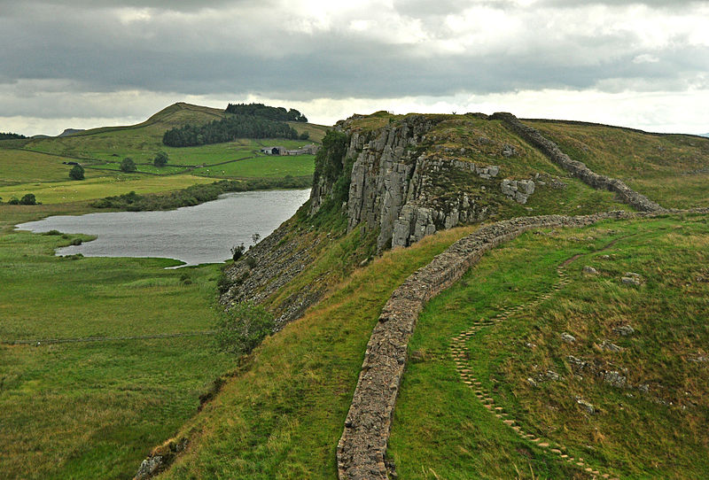
Hadrian’s Wall and Crag Lough, © Nilfanion Rights: https://creativecommons.org/licenses/by-sa/3.0/deed.en
I’ve stood many times on The Wall, once on a blisteringly icy New Year’s Day wind that froze my nose and ears, and thought about the poor Auxiliary grunts who had to man this wall. One 500-man unit were Moors from northern Africa! How they must have suffered. The Wall and its associated forts and towns (i.e. Vindolanda) operated for nearly 300 years; generations lived and worked in the shadow of the Wall.
Did it ever occur to the Romans that ancient volcanic activity gave them their line of defence? I doubt it.
So, what is the Great Whin Sill?
Across the northern parts of the UK, close to my old home city of Newcastle, rises a magnificent volcanic intrusion weathered out into the landscape. Yes, even in Durham and Tyneside our landscape is shaped by volcanic activity! Welcome to the “Great Whin Sill”.
“Whin”, is northern UK word for a kind of rock considered too tough for shaping and building. A rock so hard, its resistance to weathering offered a natural defence line for Roman engineers and their Wall. Most people will have seen photographs of the Wall perching on scenic crags as it winds across northern England from sea to (ahem) shining sea.
(By the way, “Whin” is also a word for the harsh, thorny gorse that frequents the area. Other, more fanciful sources have also arisen.)
That hard rock is a Dolerite. The Whin Sill appears in County Durham, Northumberland and Cumbria. It’s not simply a single, long ridge as the scenic pictures of the Roman Wall might suggest. The Whin Sill is a huge underground volcanic block, created in a series of four major subterranean intrusions, or swarms. It stretches from the Teesdale area, north to Berwick. It also spreads under the North Sea beyond the local coastline. Its average thickness is around 30m, and the maximum known thickness is approximately 70m.
There are two stages to the intrusions. The Little Whin Sill which intruded first, and The Great Whin Sill which is made of several major swarms.
(Being stubborn northerners, the locals also apply the term “Sill” to sandstone outcrops, too, like the Firestone Sill and the Grindstone Sill, puzzling many young geologists.)
The “Great Whin Sill Dolerite Complex” formed some 295 million years ago (“before present”, give or take a year or two), at the end of the Carboniferous period and the start of the Permian. The Complex came about during the continental manoeuvres building the Pangaean Supercontinent. Within this landmass, Britain lurked around the tropics and the area in question was under a shallow sea.
The insertion of magma dykes and the associated large spreading sills came about from crustal extension. The sills slid naturally through the local strata, underlying the current (and rather depleted) coalfields and limestone strata.
The Complex is estimated to contain a volume of around 215km3 of Dolerite in a network of ancient dykes and extensive sill sheets. The visible parts are estimated to have cooled underground over 60 years. The overall spread of the system covers about 4,500km2.
For Volcano Café’s hardened petrological experts, the majority of the rock is a medium to fine-grained quartz-dolerite containing plagioclase (largely Labradorite), with coarser grains of pegmatite appearing in more central parts of the intrusion. It is mostly a typical tholeiitic (containing less sodium), but transitional to alkaline.
Like slow-cooling deep intrusions, columnar structures are often found in exposed areas, so the Giant’s Causeway has a rival!

Whin Sill at Spindlestone Heughs © Copyright Andrew Curtis and licensed for reuse under this Creative Commons Licence.
The Little Whin Sill (which is exposed in Weardale) is an earlier intrusion, and is geochemically slightly different to the main Whin Sill intrusions being mostly olivine bearing and more ‘primitive’.
Basaltic ridges (i.e. Cauldron Snout river cataract) show some of the Sill magma may have reached the surface through fissures.
There are four major segments or ‘swarms’ to the intrusions. Off to the north east coast there is the Farne Islands dyke and sill. Here, at Holy Island of Lindisfarne, the castle is prominent on a dyke which, down by the beach still shows the hardened limestone contact skin. Like Lindisfarne castle, the famous Bamburgh and Dunstanburgh castles also stand on dykes. These emplacements were through the carboniferous block that surrounds the nearby Cheviot Hills Devonian volcanic block (and that is another story).
South and west, from the shore, can be found the Alnwick Sill and Dykes swarm. Further west the famous Hadrian’s Wall tops the exposed and tilted Great Whin Sill swarm outcrop popularly photographed.
The Complex’s southern swarm area rises to provide the lovely waterfall, High Force in Teesdale. Nearby in County Durham one can find outcrops of the Little Whin Sill swarm, which precedes the rest of the Sill development.

High Force, Teesdale. (Own Photo)
The result on the northern landscape is a rough kind of “box” shape of sills surrounding County Durham and southern Northumberland. Westwards from Alnwick the north of the box includes the famous Hadrian’s Wall exposure, to the west the Pennine Escarpment Sill runs north to south (to keep those pesky Cumbrians from invading) This sill provides one of the most amazing views in Britain over the Vale of Eden to the Borrowdale Volcanics of the Lake District and the Firth of Forth.

High Cup Nick. A deep chasm on the Pennine fellside, this famous nick, a dramatic geological formation at the top of High Cup Gill is part of the well-known Whin Sill. © Copyright Marathon and licensed for reuse under this Creative Commons Licence
The bottom of the box is the Little Whin Sill, more of the Great Whin Sill, and the “Hett Subswarm” that is a set of dykes (Hett Dyke and Ludworth Dyke) running west to east.
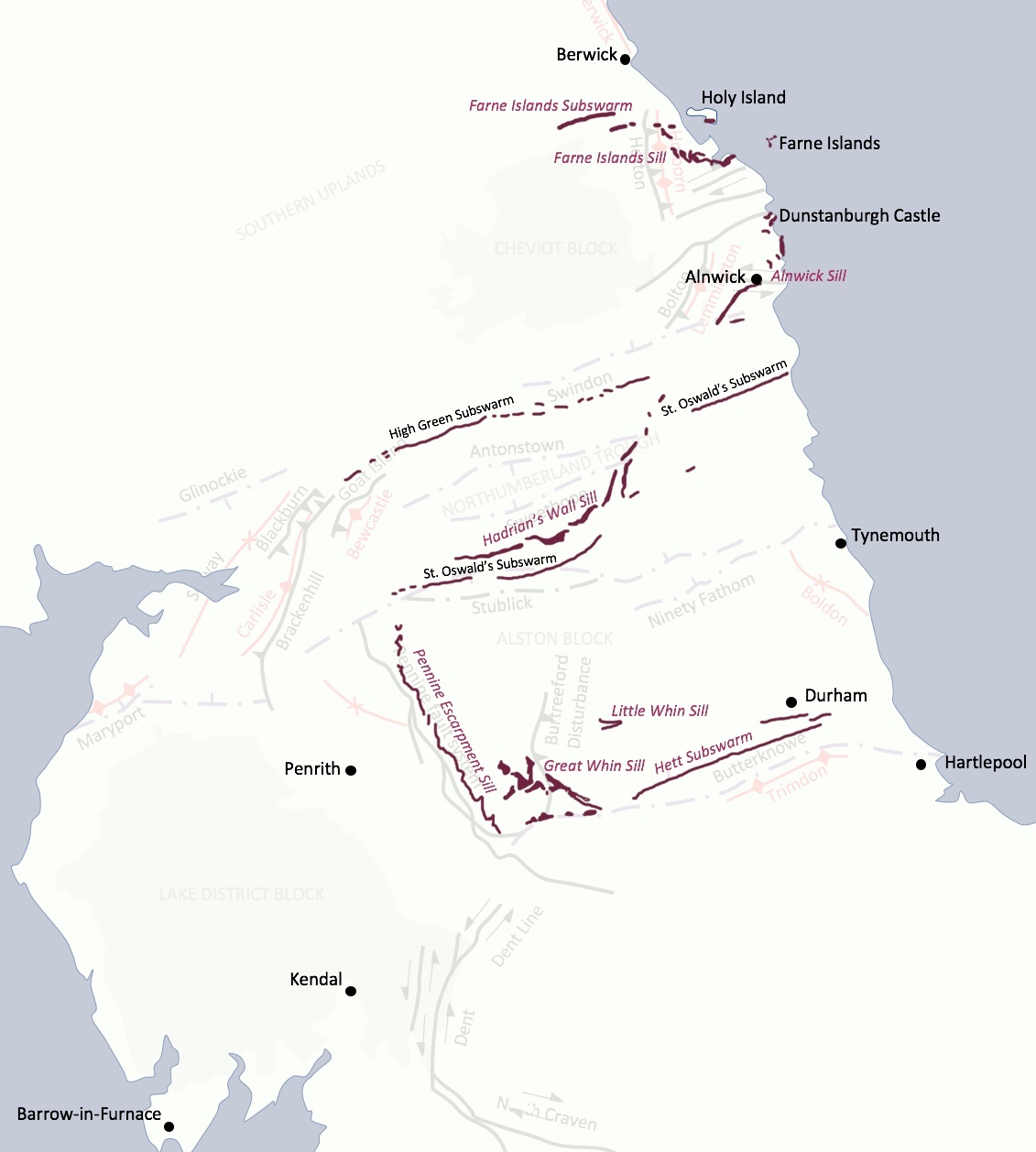
Map of Exposures of the four Whin Sill components. Reprinted with kind permission of Ian Patience, http://www.geologynorth.uk
For the petrologists, I have supplied further reading at the end for you to get your geochemically-stained teeth into.
Naturally, the intrusions affected the local Carboniferous rock. For example, contact metamorphism is most visible in Upper Teesdale where the local limestones have been morphed to a marble known locally as “sugar limestone.” Instances like these affect the local botany. Here can be found the unique “Teesdale Violet” and blue Spring Gentians, taking advantage of the shallow soil that restricts trees and bushes. Upper Teesdale also has a magnificent juniper forest. Local nature is greatly influenced by the varieties of rock.

Outcrop of Sugar Limestone © Copyright Andrew Curtis and licensed for reuse under this Creative Commons Licence.
You may be interested to learn that under the Whin Sill Dolerite, the granites at nearly 1km depth are fissured and full of warm water. The Weardale granite waters have an ambient temperature of 46°C! Geothermal energy remains a possibility for the north east of England.
The local tough Dolerite is also used for roads, too. Many northern roads are layered with Whin Sill chippings wrapped in the splattered tar-spraying system favoured for surfacing UK roads. Northern motorists have the frustration of super-hard Dolerite pinging off their paint, and shattering windscreens driving along a freshly sprayed road.
Many people think of the north east of England as coal mines, smoke, slag heaps and dirt.

Pleasley Colliery North Shaft Headgear
© Copyright Chris Allen and licensed for reuse under this Creative Commons Licence.
Instead, think of the volcanic basin that shapes the area and gives it its rich texture of dramatic outcrops, castles perched on ancient dykes, and magnificent waterfalls. Northumberland, Durham, and Teesdale have immense variety in their untouched landscapes. And volcanic activity forms a part of that variety.
And I’ll leave you with a final thought: the Roman Auxiliaries shivering on the Wall were hundreds of miles from Vesuvius, Etna, Stromboli and the Phlegraean Fields of their warm homelands. Yet they stood guard on a massive outcrop of volcanic rock!
Postscript. Written by one with no geological or volcanological education, this short summary omits a whole host of interesting geology, volcanics and petrology. It also omits many landscape features, proper volcanic information, and wildlife implications. I apologise, for I simply cannot fit it all in! I hope instead it will give some of you an incentive to explore the region and find out more for yourselves.
(See below for references / reading.)
Clive
References and further reading
Geology
- Young, Brian. Hadrian’s Wall & the Great Whin Sill
https://www.geolsoc.org.uk/GeositesHadrian, accessed 15 April 2020.
- The Whin Sill
https://www.geologynorth.uk/the-whin-sill/
This is a good summary and provides maps. - The Farne Island Sill and Related Dykes
https://www.geologynorth.uk/the-holy-island-sill-and-related-dykes/
- The Alnwick Sill and Related Dykes
- The Little Whin Sill.
- Wikipedia: Whin Sill
- Wikipedia: The Geology of County Durham
https://en.wikipedia.org/wiki/Geology_of_County_Durham#Late_Carboniferous_intrusive_rocks
- Early Permian magmatism
http://earthwise.bgs.ac.uk/index.php/Early_Permian_magmatism,_Northern_England
Hadrian’s Wall
- History of Hadrian’s Wall
- Africans at Hadrian’s Wall
https://www.blackpast.org/global-african-history/africans-hadrians-wall/
Biology and other
- Hadrian’s Wall Country
- Sugar limestone and plants
Moor House to Upper Teesdale IPA
https://www.plantlife.org.uk/uk/nature-reserves-important-plant-areas/important-plant-areas/moor-house-upper-teesdale - Wildflowers Northumberland
- Botanical species native to Northumberland


Excellent post . really appreciate the time and effort.
Many holidays and walks around Berwick and Alnwick.
Great to see it in another light.
These are indeed enormous intrusions
Flood Basalt plumbing systems
Some dyke and sills in McKenzie Igenous Province in Canada can be traced for well over a 1000 kilometers.
The eroded roots of flood basalts.
Many 1000 s of km3 in these.
Whin Sill is huge enough well over
200 km3 of Thoeltic Basalt
The entire intrusion must have taken many 100 s of years to cool?
The dolerite is something between basalt and gabbro in cooling rate, so it cooled fairly slowly
Huge magma systems are common on low gravity worlds where bouyancy is very low.
Jupiters moon IO contains some enormous basaltic magma chambers and sill systems.
Whin Sill is probaly Ionian in scale.
Nice article Clive. Thanks!
Makes me eager to explore … 😊
Nice read! Due to my own ignorance / assumptions I always thought the Whin Sill was connected to the North Atlantic Igneous Province + opening of the Atlantic 60-50ma. Now I realise its much older!
Do these 2 intrusions intersect anywhere that you know of??
Excellent article about a favourite area of mine. I disagree about whin being gorse though, over this side of the pennines at least whin is bilberry and we go out in summer picking the wild whinberries on the fell.
whinberries are the same in south wales 🙂
Ah, was there in the previous century… Always longed to go back, but nowadays I’d rather go to a country where, although speaking a funny language, people accept my Euros as is and the customs don’ t look like they have been on a summer course in the USA.
the map of outcrops of the Whin sill doesn’t half look like a map of Mordor – always wondered how they got that box shape of mountains
I always wondered that as well!
Taal awakening ? https://earthquake.phivolcs.dost.gov.ph
The swarm is centered in Mabini, 30 km away from Taal, I would say it is unlikely to be related to the volcanic system.
There seems to be a fault in Mabini that produces strong earthquakes from time to time:
https://www.gmanetwork.com/news/news/regions/606452/batangas-tremors-spawned-by-unnamed-fault-in-mabini-town-phivolcs-specialist/story/
Did you see the article in the Guardian about the 2018 Kilauea eruption being related to excess rainfall? Sorry can’t link.
https://www.theguardian.com/world/2020/apr/22/record-rain-triggered-2018-kilauea-volcano-eruptions-hawaii-study?CMP=Share_iOSApp_Other
Gah. Another new top level article, another dead cat bounce. Etna blows up, and not even one comment here about it.
I give up! I guess I’ll just have to cure COVID-19 to get things back to normal around here.
*sigh* Off to dust off my old chemistry kit …
Regretfully, I feel te same. Verry little volacanoism
(touched the wrong part of my tablet’s screen apparently). Anyhow, I also would like the focus to shift back to volcanism.
Reykjanes has decided to quiet down, Grimsvotn is purring along, Naples is all quiet (and we were promised the Phlegraean Fields would erupt in 2020).
The common denominator in the biggest disasters is that two major, independent events happened close together. For instance, two major eruptions within a few years, or an eruption followed by an epidemic (https://www.volcanocafe.org/apocalypse/). Or, as a hypothetical example, a big eruption while we are recovering from corona.
There is more commentary in the bar, though not on Etna. It is all about blowing up Kilauea using rain.
https://m.youtube.com/watch?v=NrbdYcNTo7Y
https://m.youtube.com/watch?v=st_2C_Wrw4A
Amazing informative well done videos on hotspots and flood basalts.
Albert is this what woud happen If example the Hawaiian hotspot was placed under the Baltic Sea?
Luckly its under a ”relatively thin” oceanic litosphere that allows frequent constant eruptions.
If it was placed under Scandinavian Craton, woud that mean flood basalt
armageddon?
The very thick litosphere woud trap and ammount the magma.. until all hell breaks loose?
If Hawaiian hotspot was placed under Finland, I imagines a huge boulge woud start to grow.. in Scandinavia.. the boulge is 1400 km wide and 1 kilometers high.
Thats called ”litospheric domeing”
Until all hell breaks loose..
Albert what woud happen in this ..
imaginary geological scenario?
I haves asked before… But Im curious
Dust Devil whats your opinion?
Will all hell break loose ( If the migthy Hawaiian hotspot was placed under the Baltic Sea )
The very thick litosphere woud trap the ammounted magma over time
One thing’s for sure, Putin would try to cash in on it! Best, Chris Stilton.
Probably nothing would happen. It is a strange thing that almost all suspected hot spots are underneath oceanic crust. At the moment, Yellowstone is the only one under thick continental crust. Whether the east africa dome is a hot spot is unclear – if so it is centred under Tanzania, well away from the rift. Yellowstone has domed but erupts very infrequently. When it did its flood basalts, it was underneath thin continental crust. So don’t put it under Finland. Much better placed under Denmark.
Thanks… but also remember… Hawaiian Hotspot is very very powerful and intense
Hot as hell litteraly it is… most if not all other hotspots are cooler to much cooler
Hawaii is a very hot one. ( close to 1600 C a bit down under litosphere )
Are you soure that nothing will happen if it was placed under baltic sea?
Siberian Traps coud been souch an example…
Siberian Traps was a very powerful hotspot that emerged in a near cratonic enviroment
Yellowstone is an example
But thats not a very powerful hotspot
Now imagine What woud happen If a Superplume was placed under a Thick Craton
Africa coud be an example of what I talks about…
But African Plume seems pretty spread out
and not as Intense as the Hawaiian.
Thick continents and specialy supercontinents traps the Earths internal heat
“Almost all suspected hot spots are underneath oceanic crust.”
That’s interesting. Do you think that is because they are easier to detect than ones under continental crust (i.e. one that lurk, but do not actually do much…)?
Some just leave trails of unusual alkalic volcanoes, like the one that made Mt St.Hilare, and there is a similar chain in Brasil which I believe leads to Tristan da Cunha offshore.
Tristan da Cunha is a very weak dying hotspot indeed these days…
Its probaly what the migthy hawaiian
will look like when it cools off, in 100 million years in the future
Tristan doesn’t produce large eruptions, but is far from extinct as a hot spot. There was the 1962 event, another Tristan eruption on the other side of the island dated to within the last 400 or so years, and within the last few years a submarine eruption at Nightingale Island -probably far enough distant to be deemed a separate volcano, but part of the same hotspot
Like the Cosgrove Track in East Australia, this small hotspot seem to have gone extinct 9 million years ago.
I can’t think of any of such continental trails of alkalic volcanism that are active right now, maybe Yellowstone is really the only current continental hotspot.
Michael
Tristan Da Chuna is not much to look at
A very weak Hotspot compared to Hawaii and Iceland
Thank you folks for your kind words about my article!
You deserve all the compliments. Well done.
I’ll admit, I never heard of this area before you mentioned…But it’s not like I liked your article! BAKA!
Perhaps one of the less surprising results of the day: trees growing near an erupting volcano don’t do well.
https://www.bbc.co.uk/news/science-environment-52400686
Tree ring data is very useful across many disciplines.
https://en.wikipedia.org/wiki/International_Tree-Ring_Data_Bank
Shouldn’t have said that the Phlegrean fields were quiet.
Perfectly time Albert!
New post is up! Will it – won’t it? Tallis is asking for our input.
https://www.volcanocafe.org/calling-all-volcanians/