
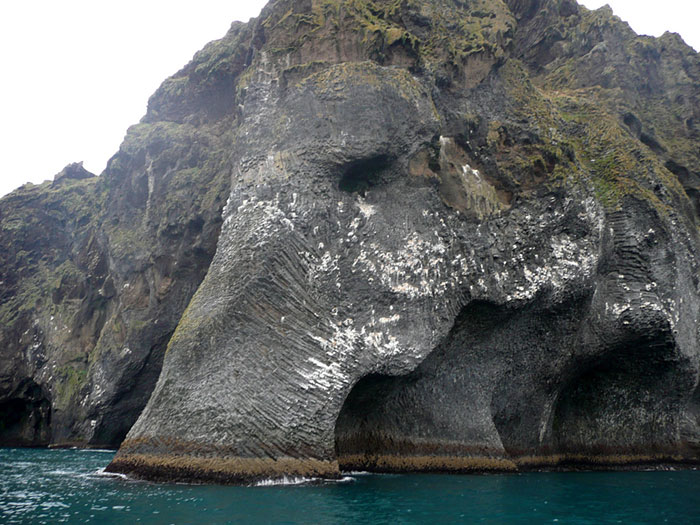
Heimaey is famous. It is the only place in Iceland known to have first been settled by non-Vikings: the first inhabitants were escaped Irish slaves, before 900 AD, who didn’t last long. Much later it suffered a devastating slave raid. And of course, it has an elephant. But all that history pales in comparison to the events of 1973, when people on Heimaey fought a volcano and (for the first time ever?) won. The volcano has remained subdued ever since. It surely beats an arctic elephant.
No one had seen it coming. The island was volcanic, of course – every part of Iceland has a volcanic history. But no eruption had happened here for almost 6,000 years. Given that, how low was the chance of another eruption? It turns out, the chance was 100%. It was not a matter of if, but of when. The ‘when’ came in 1973, when the eruption that couldn’t happen destroyed a third of all houses and almost caused the entire island to be abandoned. Even for Iceland, this was an extreme event. Eruptions in Iceland happen in unoccupied regions (Icelandic people tend to be sensible when choosing where to live) and are an inconvenience but rarely a danger. The last eruption that caused a large evacuation (to Canada) was in 1875, at Askja. Why did Heimaey decide to erupt in 1973? We don’t know, and no clear precursor activity was ever seen. One paper suggests that it may have been caused by magma left over from the Surtsey eruption a decade earlier.

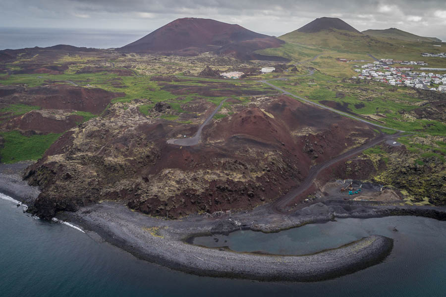
Heimaey consists of a low-lying central area where the town, airport and of course the golf course are located, and hills and cliffs along the edges. One of those hills wasn’t there. Eldfell, on the eastern side and 200 meters tall, only formed in the 1973 eruption. The older hills are also volcanic. The northwestern edge of Heimaey has a deeply eroded volcano of which part of the crater wall survives. It is called Nordurklettar. Southwest of Eldfell are two other cones, Saefall and Helgafell. Just off the map but connected to the island by an isthmus is a third one, Storhofdi. Look further to the southwest, away from the island, and you’ll find other volcanic stacks, forming a linear volcanic zone extending from Heimaey. On the other side of Heimaey you’ll find two more islets (also of volcanic origin although old enough to have become eroded and greened), before hitting the main land. Keep going, and soon you’ll find that 2010 volcano with the unwritable name. Another eruption here was just a matter of time.
Heimaey is the oldest of the Vestmannaeyar islands, and the only one to date to before the ice ages. All other islands here formed during the holocene, and they have a limited life expectancy. Many more cones are scattered on the sea floor: more than 50 have been counted. A quick tally of 50 eruptions over 10,000 years suggests that an eruption can be expected in the Vestmannaeyar archipelago every 200 years or so. The five volcanoes on Heimaey suggest that some 10% of the eruptions here happen on the island itself. In reality, there have been about 10 holocene eruptions here, of which Nordurklettar, the oldest, accounts for five. Eruptions on Heimaey itself tend to be larger than elsewhere in the archipelago. Currently, the entire area is monogenetic and every eruption creates a new cone. But the cones on Heimaey are becoming very close together, and it seems the island may be in the process of becoming a new central volcano. However unexpected, the 1973 eruption was no surprise.
Before the post-ice-age sea-level rise, this was all land. Most of the volcanoes formed at or just above sea level, but this level varied with time. Nordurklettar may have fully formed within a 500 year period during the Younger Dryas. Storhofdi is the next oldest, followed by Saefell. Saefell is much larger than it seems. It is a tuff ring, which has been partly eroded by the sea but originally had a diameter of 3 km. At the time of its eruption, sea water had free entry into the crater, and the eruption was almost entirely phreatomagmatic. This eruption happened about 6500 years ago. It was the largest of the Vestmannaeyar eruptions, producing about 1 km3 DRE in total.
The next youngest is also the most obvious one, at least prior to 1973, as its lava fields cover 50% of the island. This is Helgafell, a 230 meter tall cone which erupted abut 5900 years ago. It erupted on the outer flank of the earlier Saefall eruption. Helgafell produced at least 10 different lava flows, from separate eruption episodes. The progress of this eruption is fairly well known from studies of the lava flows. It started with a spatter phase from high fire-fountains as the rift opened. This phase fed thin flows, seen towards the east, but mainly produced tephra and scoria. A sheet lava flow followed while the eruption rate remained high. This sheet went west where it covered the earlier spatter flow and eventually reached the coast. In a third phase the lava flows went northwest. In that direction was a narrow strait separating two islands. The Helgafell lava filled the gap and caused the unification of Heimaey.
The individual lava flows of Helgafell lasted at minimum 1 to 3 months. The lava flows came from separate phases, perhaps with quiescent phases in between. The total eruption lasted a minimum of 7 months, and possibly much longer, with the northwestern flow being the longest-lived. None of the phases produced explosive ejecta. In this area, explosive eruption tend to come from (sea) water infiltrating the eruption site. Helgafell was above sea level, albeit not by much. The total eruption volume was about 0.6 km3 DRE. It was very similar to the Surtsey eruption in both duration and volume. The extended eruption with seperate phases is the normal eruption mode for the archipelago (although most eruptions, like Eldfell, are a few times smaller in volume). For comparison, Holuhraun had a similar volume but consisted of a single eruption. Krafla, on the other hand, also had a series of subsequent rift eruptions as part of a single event.
In spite of the clear volcanic history, and the Surtsey eruption a decade before, no one saw it coming in January 1973. The UK had just joined Europe, the US had legalised abortion through the Roe vs Wade case, and Nixon ended the Vietnam war. The modern world was taking shape. Late on Jan 21, an earthquake swarm was noted near Heimaey at a depth of 20 km. It lasted until the next morning. The earthquakes were too weak to be felt, with the highest magnitude 2.7. And, with only two seismographs on the main land registering the swarm, we can’t be sure it was really at Heimaey. The other possible solution is underneath Torfajokull. The quakes resumed at 11pm on Jan 22, with seven detected tremors until until 01:34 on 23 January. These were shallowed and clearly underneath Heimaey. Apart from this possible precursors, recognized in hindsight, there was no warning.
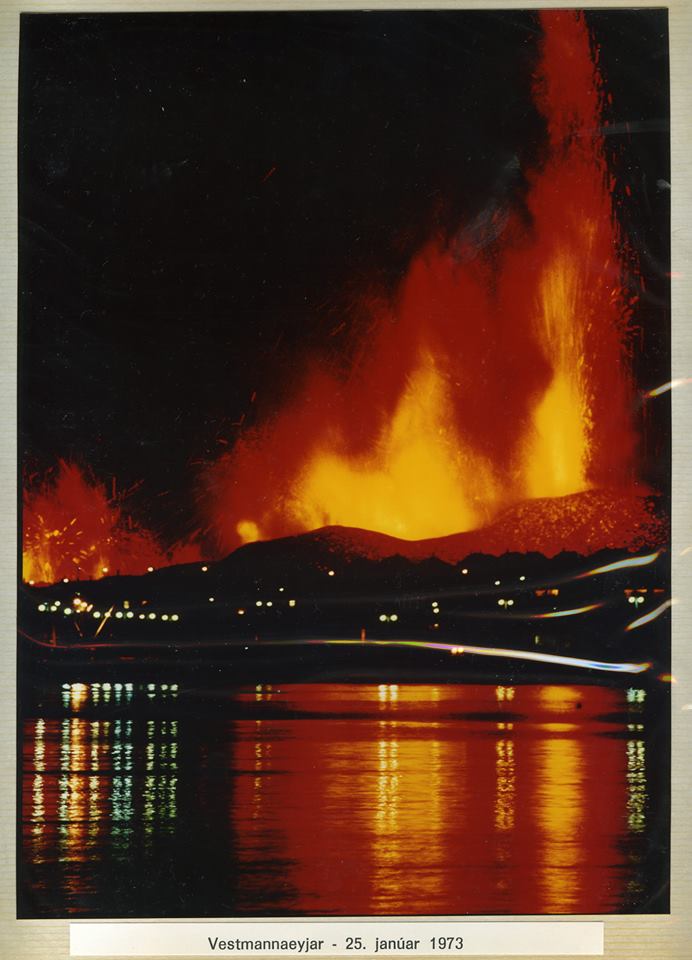
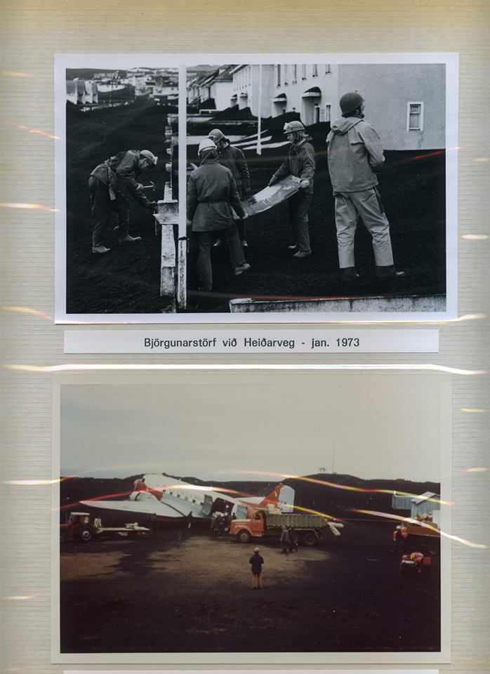
On Jan 23, at an unfashionable time of 1:55am, the earth opened up with a noise like thunder – but without the preceding earthquakes you might expect when something rifts through rock. A mile-long fissure had suddenly formed with more than 30 separate fire fountains, at a temperature of 1050 C. The fountains were up to 150 meters high. The eruption column reached up to 9 km. The rift ran from the Saefall rim, past Helgafell, to the north end of the Helgafell lava field. The active rift passed less than 300 meters from the town. The 5300 inhabitants were at immediate risk. They had a few lucky breaks. The wind was west (not that common in this area) which pushed the ejecta away from the town. The land sloped away from the town, so the lava did not flow towards the town, at least initially. The evacuation started within an hour of the first eruption, and by mid-day the island was empty. This was possible because of a third lucky break: a storm on the previous day had caused about 70 ships (almost the entire fishing fleet of the island) to take shelter in the local harbour, so transport was immediately available. The fourth aspect was not a matter of luck but of preparation: Iceland had an emergency plan ready, just in case, and it called for immediate evacuation. Most people were taken by sea but hospital patients were evacuated by air. By evening, emergency accommodation had been organized in Reykjavik by the Red Cross. Many evacuees were taken in by relatives.
Within twelve hours the outer ends of the rift died down, and the eruption shortened to 600 meters. During the remainder of January this shortening continued, the fountaining ceased and the eruption now focussed on the area closest to the town where Eldfell (‘fire mountain’) began to grow. (The locals gave it the name Kirkjufell, because the rift ran close to the old church, but this was overruled by the main land.) By now the ash and tephra in the nearest part of town reached 2 meters depth, and lava covered 1.5 km2. The earthquakes that were detected at this time came from a depth of 20-25 km.

Not all the eruptive activity was on land. During the first few days of the eruptions when the entire rift erupted, there were reports of under-water activity on both sides of the island, near the coast. This indicates that the rift extended beyond the island, and was in fact over 2 miles long. This subsea activity ended by Jan 24, but may have briefly resumed north of Heimaey in early February, when both the electricity cable and one of the two 15-cm wide water supply tubes to Heimaey became severed. It is not clear whether this was underwater activity or caused by lava flowing into the sea. In late May, while the eruption was winding down, under-water activity was reported four miles from Heimaey, close to the main land.
Eruption rates during the early phase were around 100 m3/s. In early February when the activity had focussed on the growing Eldfell the eruption rate declined to 60 m3/s. This was another reason why all other parts of the rift died down: the magma pressure had declined a bit. Eldfell (as yet unnamed) now developed a crater with a small lava lake at the head of the lava flow. This is normal behaviour for rift eruptions, but it can be risky as the fresh crater walls are made of little more than loose rubble, with a lack of cohesion. Indeed, it quickly became too much and on Feb 19 the crater wall collapsed – on the west side, i.e. towards the town. Some houses were completely buried under the rubble. But worse was to come, as now the lava began to flow through the town and headed for the harbour from where the population had escaped.

The lava was highly viscous and made slow progress. The flow carried debris with it, including tephra and lava bombs. In fact, it even carried part of the collapsed cone as an enormous lava boat. In Icelandic fashion, it was given a name: Flakkarin (meaning wanderer). This lava boat (more like an ocean liner: it measured 200 by 200 meters and was 45 meters thick) headed north, to the harbour entrance, at some tens of meters per day.
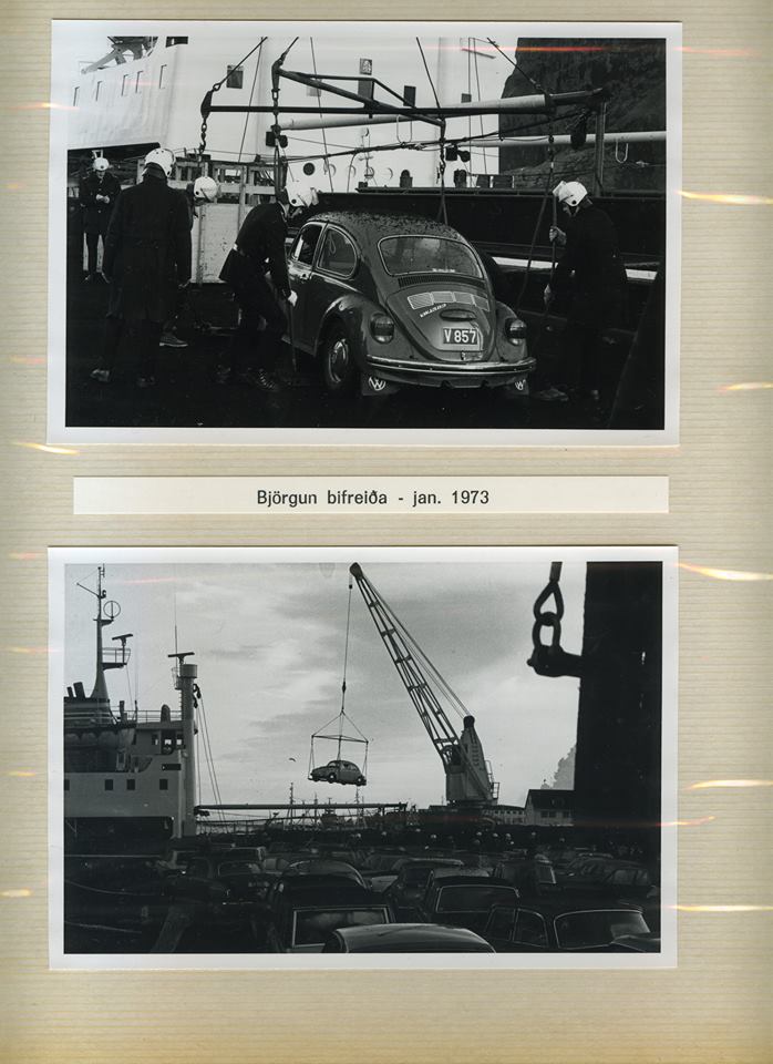
Some 250 people had returned, to volunteer for emergency work, such as rescuing possessions and safeguarding houses. They looked on with concern. The volunteers had already tried to safe houses by removing the thick ash from the roofs and installing corrugated iron and steel plate covers on east-facing windows to stop lava bombs from getting in to the houses and setting fire. Now that work seemed a waste of effort. The harbour was essential to the town: without it, there was no sheltered access to the sea, and this is the first thing any fishing village needs. The lava boat could have blocked the harbour by itself, but it broke in two and grounded itself before it could do so, having traveled for about 1 kilometer.
The dangers ebbed and flowed during the eruptions. Initially lava was heading northeast, away from the town (it was extremely lucky that the rift wasn’t 500 meter further west which would have left many people at immediate danger and without escape). After Feb 4 the flows went northwest, towards the town, but on Feb 9 they changed direction and again went northeast. After the Feb 19 collapse, lava went decisively west and north. Much of the destruction happened between March 22 and March 26 when over 200 houses where engulfed in lava, and the flows stopped less than 100 meters from the port. After April 4 the threat to the town ceased.
While this was on-going, people decided that the harbour was worth saving. This required containing both the west and north flows. But how? A proposal to bomb the crater to create an outflow channel away from the town was rejected as too risky. A barrier was build to impede the flow into the town, but the lava soon overtopped it in some places and in other places just incorporated the barrier into its advance. The centre of the town was quickly overrun. The lava flow was already more than 10 meters thick and was not easy to contain!
As a trial, in February water was sprayed on the flow to cool the surface and to slow the lava down. Water cooling had first been tested at Surtsey. The trial suggested that it could indeed help. In March and April, the water fight began in earnest, using leased US pumps. The fact that the danger area was right next to the sea helped a great deal, since sea water could be pumped directly on to the lava. The pumps were impressive: water was pumped continuously at a rate of 1 m3/s, at a time the lava eruption rate was perhaps 10 m3/s. The heat capacity of water is four times higher than that of rock: as long as it remains in contact, water can cool lava very well. But it was hard to reach far into the flow, as was needed if the attempt was to achieve more than just creating another barrier. That was achieved by first cooling the flow front, and once this had solidified, create an access over it with the help of a bulldozer. Pipes were laid directly on this. The water flowing through the pipe stopped them melting. However, this did mean that much of the heat capacity was used on the pipes rather than at the end point. The massive project managed to solidify the top 10 meters of the lava within about two weeks.
The people who remained to work on the island have some story to tell. (The link is to a story by the son of the owner of the engineering firm that handled the work.) Steel helmets were needed to protect against the falling stones. At night they slept with candles, not for the light but to check no deadly volcanic CO2 was seeping into the room. One person died from this, when breaking into a basement.
While the lava continued to advance, eruption rates at Eldfell were actually dropping fast. By the middle of March, when the barrier was overtopped, it was only around 10 m3/s, a tenth of its early vigour. During April, the lava flow expanded at only 5 meters per day, although the flow field continued to thicken: eventually it reach a thickness between 10 and 100 meters. The lava itself had also changed over time, becoming less alkaline and a bit hotter. While the magma chamber was being emptied the eruption continued to slow down. On June 28, activity at Eldfell ceased, and on 3 July the eruption was declared over, with the harbour still accessible. The people had won.
The eruption left Heimaey badly damaged but not destroyed. Many houses were gone but the village had survived. The harbour had narrowed but remained usable. In fact it had gained a new break water, and as the lava eroded it even acquired a beach. The island had grown in area by about 10%. People saw an opportunity. Some of the ash and tephra was used to build a new, extended runway. Heat from the cooling lava was used to warm the houses: this lasted until 1989. And perhaps best of all, Flakkarin was still there. The wanderer was turned into a viewing point, with its own parking place. Iceland does not let its volcanoes go to waste.
Flakkarin
But did the water cooling rescue Heimaey? Did it win the war? Clearly it did manage to cool the lava, but this leaves two questions: why did it work, and did it change the outcome? As for the first question, it benefited from some unique aspects to Heimaey. Numerous (43) large pumps were available, with enough power and support to run them. There was no shortage of water: the sea was right next door. The lava was viscous and slow, and this bought time. But most importantly, by the time the water operation started, the eruption rate was already quite low. The water pumps managed to keep up.
Did it change the outcome? That is harder to know. The eruption was already slowing down and would soon end. It is easy to gain a victory when the opposition is no longer there. Probably the flow field remained smaller because of the water. But perhaps not by much. When flow rates decline, the lava cannot flow as far because it cools faster and solidifies closer to the source. Lava can still flow underneath the flows, though, causing the flows to thicken and expand. But the water cooling did not reach these deepest layers. It is likely that the flow was already reaching the limits of its extent, and would not have expanded much further. Of course, only a small extension might have sufficed to close off the harbour, so in that respect the water fight may well have been decisive.
25th January 1973
This is the story of a fairly normal Icelandic eruption, unusual only in occurring in a populated region. If the Reykjanes peninsula re-activates, a possibility suggested by current events, we may see similar events there in the not too distant future. But words can only say so much. The rest of this post is done in photos.
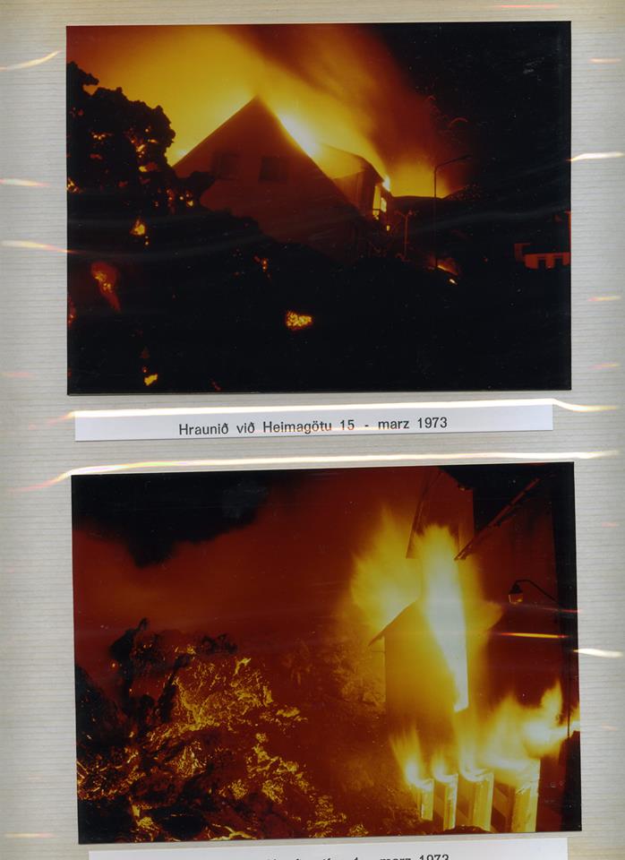
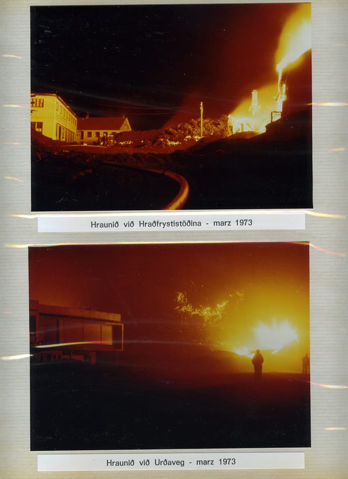
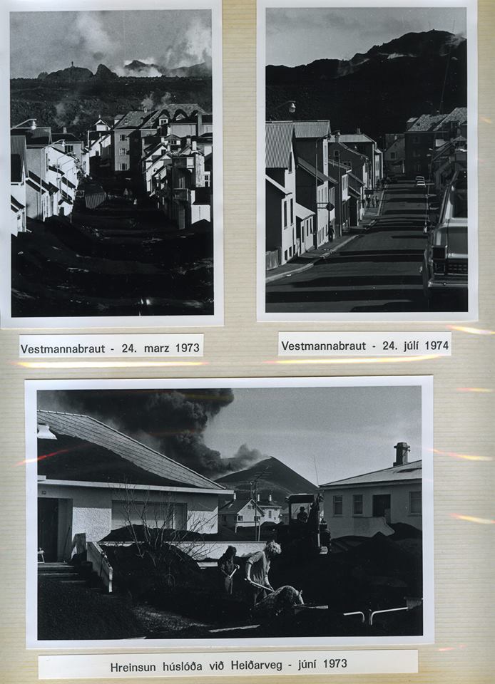
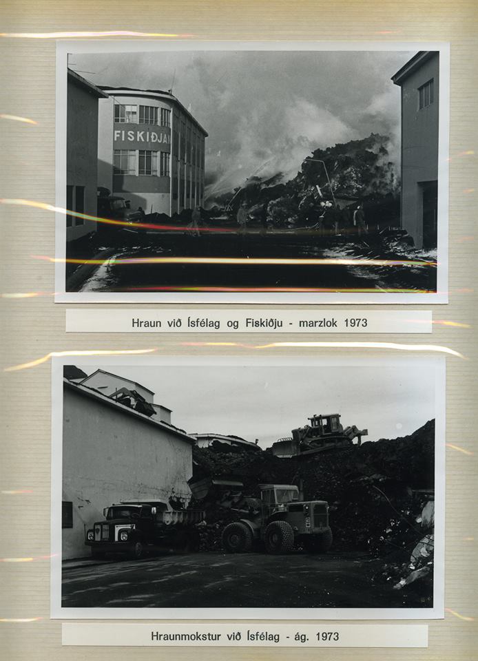
The epic photograph above was taken by Guðmundur Sigfússon and clearly shows how close to the town the eruption happened. The following photos are from the private album of Bragi Björnsson. The images were scanned by his son Dagur Bragason and were first published at VC in 2014 with Dagurs permission. They tell the story of the evacuation, and the later struggle to save a town from a volcano. These are photos from the front line of the war against the world.
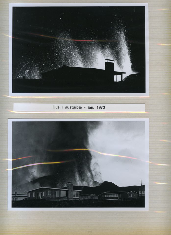

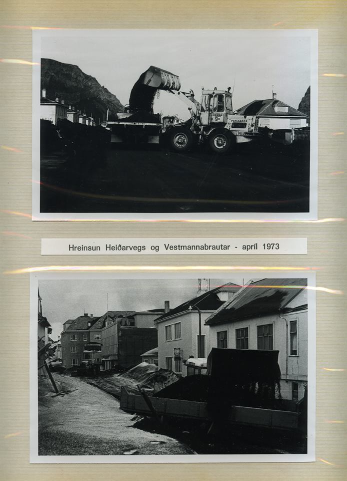
In the top photo of the last pair, notice the water pipes and the steam generated by the wet lava.
And finally, here are some photos from Kristjan Kristjansson, published by him on youtube
Many more people will have memories of Eldfell. They are memories worth sharing.


If a fissure would open close to Grindavík, we might to see similar pictures to what Kristjan Kristjansson recorded in Heimaey. Clearly the folks who live in Grindavík would not be thrilled by such a thing…
remember this very well. It is where my interest in volcanoes began at 10 years old. My parents had a subscription to Time magazine then and I remember vividly pouring over the articles of this. It was the fascination of the power of the earth and the conviction of the people trying to overcome it that drew me in. Thanks for a great read (again) Albert!
That posted oddly. It left off the ‘I’ in ‘I remember’ with no name posted and a time of 22.
My family and I visited Heimaey a couple of years ago. It was unforgettable for all 9 of us, including the children. Guess what, volcanoes are alive! We also enjoyed the best lobster bisque ever a couple of days later in Grindavik, hope is survives. Another great article, Albert, thanks.
Did you find the roads, #1 a bit congested? I think if I was to do it over I would take a tour instead of striking out. There are perils that one does not find in the usual tourist over-run destinations. Iceland with its small population has done well with connecting their communities but the roads are for that small population not the million tourists every year. If you are the driver then the road is your focus because 1 misstep and you may well be seeing if your rental can withstand basalt boulders. There is no shortage of material to start a rock fight in Iceland, contrary to rumour. There are few if any turn offs and no shoulders to pull over on. I was squeezed into the ditch west of geyser by a bus which was a white knuckle moment. Bus it if you can. If you rent do not neglect sand insurance. I ran into the reason why near the turn off to Askja. A sand storm with pumice marbles for variety. I sought shelter in a cinder cone there and had pumice landing on the roof. I found refuge at Myvatn. If you wish to see the interior look around for transportation to and from. This is frontier in the old west jargon and roaming around on your lonesome could get you in trouble. Thankfully cell coverage is good. Tenting uhm, frost on the tent July 1 at Thingivillar ( hope I spelled it reasonable close ). Tour , hotel, comforts next time. lol
Eyrabakki!
1050 C for a basaltic magma?
Thats pretty low temperature and explains the high viscosity.
What was the viscosity of Heimeay in Pa.s ? Holuhraun was at 50 Pa.s
Heimeay must have been alot higher!
Thank you for this article. I vividly recall that eruption as it was reported on the television and in the papers. It was probably the event that started my interest in volcanoes!
Wow thats a rather low temperature for a basalt ”only” 1050 C. It must have spent some time underground cooling in an already in existence chamber.
Surtsey was fresher and 1140 / 1160 c and therefore far more fluid.
Yes, it was relatively cool. Later lava was a bit hotter.
Many many thanks to Dagur Bragason for sharing this epic photo set!
https://www.forbes.com/sites/jamiecartereurope/2020/08/15/revealed-daring-nasa-mission-to-explore-an-ocean-of-lava-on-jupiters-volcanic-moon/#5823f620476c
Still no hlaup from Grímsvötn. The updated text refers to a GPS placed on the surface of the ice shelf. Could this be GRVC? In that case GRVC would react to ice movements, lake level changes as well as bedrock movements.
https://www.vedur.is/um-vi/frettir/hlaup-gaeti-hafist-i-grimsvotnum-a-naestu-dogum
GRVC had a hick-up two days ago and has been noisy since but its regular inflation has resumed. It seems on the edge but if this is indeed located on the icecap on the lake, then the actual jokulhaup may not have started yet.
Is there any way to be able to read the 2014-2015 posts about Bardy? I was able to go back to mid 2015 in the posts but there seems to have been some sort of theft or hacking or so, causing previous articles to be deleted. If I understand it in the comments of the time.
What actually happened?
They can be found here https://volcanocafe.wordpress.com/
Great article Albert., and astounding synchronicity – just yesterday i began re-reading John McPhee’s ‘The Control of Nature’ with a large section devoted to the icelandic cold-war ‘Battle of Heimey’ in ‘Cooling the Lava’. Fortunately that book was first serialized in the New Yorker magazine and is still available online here .
Heimaey means literally “Island of homes”. Heima is the genitive plural of Icelandic Heimur.
It is the only inhabited island of the archipelago, so that name makes sense.
Has the Grimsvotn jokulhaup started?
Note: the GPS went down by 3 meters almost instantly, before cutting out. Ouch.
I don’t think it started yet. The GPS went out yesterday and there are still no signs on the tremor plot. I think it’s just a malfunction, or it went down a crevasse or something.
Could be. It has been reliable so far but anything can have happened. For instance, snow collapsing over it would give this effect. Let’s see what happens. If it is broken, it might get fixed quite soon.
You’re right, Tomas and Albert.
According to this article it was snow melt adjacent to the GPS that caused the misleading data, though there is still concern about the possibility of an eruption: https://icelandmonitor.mbl.is/news/nature_and_travel/2020/08/17/no_glacial_outburst_flood_but_grimsvotn_ready_for_e/
Well, Tomas was right ..
Some additional text from IMO: (auto translated from Icelandic)
“It was unusually hot on the glacier on Thursday and Friday, so we suspected that the measuring instruments had moved due to melting. It turned out when we landed on the glacier that the pole on which the measuring instruments are attached was starting to tilt due to melting, which gave a false signal that the ice cap was sinking “, says Benedikt G. Ófeigsson, an expert at the Icelandic Meteorological Office, who was one of the expedition members. “We fasten the pole securely and it should last until the autumn. Then the connection to the meter needs to be refined, which should then be in good shape later this week “.
I wonder if that pole is 3m high. Then the signal Albert pointed out could be when the IMO staff took it down before turning it off. I think the mystery of the GRVC location is solved. It sits on a pole that’s been fixed to the glacier.
There’s actually a picture of the pole. How could I miss it?
https://www.vedur.is/um-vi/frettir/hlaup-gaeti-hafist-i-grimsvotnum-a-naestu-dogum
There’s now an IMO webcam on Grimsfjall which is offering nice views at the moment. http://vefmyndavelar.mogt.is/ The temperature is showing as 21C, which seems a bit high to me.
GRVC is now back online. Looks like they drilled the new hole 60cm deeper than the old one.
Exciting stuff knowing that the volcano is highly pressurized now. Any removal of pressure like water load in the huge geothermal lake can cause an eruption. Grimsvötn is hidden under Europes largest icesheet. Any removal of load can cause eruption. The volcano haves a large magma influx and is now even more pressurized than it was in 2011. The gas emissions are also large now.
https://youtu.be/xnhZY7ooLHc
They were working up there yesterday
Great to have that perspective for all of us who just have to use our imagination to visualize Grimsvotn. The vastness was something I was struck with watching this video. Incredible!
Since we are in Iceland, Tom Scott has a short vid up about Kolbeinsey https://www.youtube.com/watch?v=hr03xF08qoU
Anyone know if the green wave on the gri plot is normal? It’s been getting thicker since this morning.
youtube Eftirlitsflug að Grímsvötnum. Time 4:19. Is it fog or anything else?
Is this Grimsvötn cam even working?
Reads 2015 on the time label upper
Maybe its not an active webcamera?
That’s not Grims, its Kverkfjöll
Question for the board. Has this summer been relatively quiet seismically speaking in Iceland? Seems like it to me or is it that the usual areas are more quiet ie Myrdalsjokull and Vatanjokull.
It has been normal, I think, and that is unusual these days.
Grimsvotn is still recovering from its larger earthquake a few months ago. It will soon become more active again. Reykjanes is still quite active but nothing like 6 months ago. Katla and Hekla do what they want: they decided to take a quiet year. And of course the north if Iceland has had quite some swarms.
I agree with Albert – it has been quite normal.
Worth noting is that Bárðarbunga has steadily gone more and more quiet after Holuhraun. At least when it comes to the smaller quakes. The larger ones still happen a few months apart. In fact, there will probably be another one (or two) around M4.8 or larger relatively soon. A few smaller quakes may happen before or after that. There is a fair chance that it happens near the onset of a jökulhlaup or eruption from Grímsvötn and then people will wonder if Grímsvötn was triggered by Bárðarbunga and I will say “no, it propably happened by chance because both events were bound to happen anyway”. (Now that I have said that I probably jinxed it so that we get another Gjálp like run up, with a big quake in Bárðarbunga, followed by an intense swarm and a sudden Grímsvötn eruption.)
https://m.youtube.com/watch?v=4vOIX3Iwrk0
Flight simulator 2020 haves arrived and its amazing!! it haves the entire world replicated in CGI, every tree, every house, every mountain and airport.
And live weather with 3D volumetric clouds.
It will be so fun to fly over Iceland!
But There is too much trees in Iceland. Autgen takes the moss and coverts it into trees that does not exist in Iceland.
Icelands volcanoes like Heimeay and Katia arera may have extensive conifer forests in the game.. that does not exist in real life. In Iceland there is b o extensive forests. Heimeay maybe covered in trees in the game.
And it will be curious how Hekla looks like.
There used to be more forest in southern iceland, before people arrived. The farming methods were quite destructive, and the worsening climate in the middle ages did not help. Of course, a 1 meter tall tree will look a lot like a shrub.
During warmer times in Miocene Iceland was almost subtropical! ( very warm temperate )
Redwoods used to grow in Iceland back then. Between the lava layers in Westfjords the oldest parts of Iceland, there is coal from redwoods like trees. If global warming is allowed to continue: thats the future for Iceland
I did not know that. But Iceland may not have enough soil to support redwoods. The soil is mostly thin and fragile and takes careful management. That may be a consequence of the ice age, when the glaciers scraped the surface clean down to the bedrock. Sweden in parts is like that – bedrock surrounded by conifer forests.
Its the ice age
( all the glaciations ) that removed most of Icelands rich soil.
Iceland been without the ice for 8 million years before the ice age started. So that was plenty of time for deep soils to form in the older parts of Iceland.
I live in Sweden.
Sweden and Finland is indeed scraped of soil by the glacials.
Swedish terrain is very rocky and cliffy and boulders everywhere and stones and pebbles are everywhere. The soil is thin and mossy
Rocks rounded.
Sweden was Subtropical too during Early Miocene with huge forests that formed the ”Baltic Amber” the climate was drying and cooling since Oligocene
The type of bedrock comes into it too; granite and high-level metamorphics like gneiss with a lot of free quartz produce thin, acid soils whereas basalts decompose comparatively fast (on a geological time scale)
https://m.youtube.com/watch?v=TWGdJaegdYM
Albert This is how Ísafjörður looks like in the game ( This is the largest game world thats ever been created!
the whole planet basicaly )
Eye stunning MFS2020
But all the tall conifer trees should not be there! I hopes they fix this very soon.
But perhaps this is how Iceland will look like in year 2200 when the climate have warmed alot. Im going to fly over Holuhraun arera too and see If I can find the 2014 s lava field in the game.
Its alot of improvment since FSX in 2006 ( But Nyiragongo volcano still looks odd in 2020 version )
Yes its a stunning game to explore the world! I flyed over Iceland and Italy volcanoes today and its absolutley eyestunning what Microsoft have created for us simmers.
The game is so large that its streams its data from servers ( so your computer does not have to render it! ).
No computer can handle souch data for itself. ( my computer woud explode )
The 3D live weather volumetric clouds are specialy Awsome to fly through!
I can agree that Iceland haves way too much conifer forest in the game.
Katla Volcano slopes is full of spurce and pines that should not be there in real life. But many volcanoes in the game match the real world version very well.
I fear that Heimeay Island will be clad in trees in the game
But I dont know really
Iceland in MFS2020 looks kind of like British Columbia with the fjords and heavy conifer tree cover.
Microsoft haves to fix Icelands scenery very soon as the game runns on massive servers.
Hi guys 🤏
Yes I had a trip to Iceland too in MFS2020 yesterday: This is a stunning game absoutley jawdropping!
This is the most incredible game world that I have ever experienced.
A powerful game computer is still recommended.
But just as Watcher and Jesper have told: there is alot of tall boreal forest in Iceland arera in the game, that does not exist in real life there. The autogen feels like it needs to place whole conifer forests at Iceland lowlands.
Iceland indeed looks like british columbia or south norway in the game.
I have not checked If 2014 s Holuhraun lava field is modelled yet in the world map.
I had a try too with MFS2020 today
And indeed Iceland is very forested.
Dense conifer forests clads Thorsmörk as example, looking like North Sweden rather than Iceland.
Microsoft haves to remove these autogen trees from Iceland in MFS2020.
But its an incredible game anyway!
Flying over Heimeay soon
Does anyone know what the area is between newberry caldera and crater lake, around 43°15’07.4″N 121°30’29.9″W? There is one of the many ‘bald mountains’ in this area, the best view I could get on google street view showed quite a drop into this circular shape. Seems like the right area for it.
Oooh, a perfectly circular crater 20k in diameter. Weird. Could also be an impact crater I guess, I wonder what the geologic map says?
Not that anyone ever reads the last post to an old thread!
https://epod.usra.edu/blog/2007/09/mysterious-circular-structure-near-chemult-oregon.html
https://www.volcanocafe.org/all-calderas-are-not-calderas/
New post is up! Where do you think the next BIG eruption will come from? https://www.volcanocafe.org/future-calderas/
Well this really IS the last post! It seems (sinister voice) “nobody knows”!
I am of the opinion it is a curved fault at the top, together with unrelated land-use features which give the appearance of a circle. I doubt there is any more to it than that.
Over to you.