There is a bit of California here. The fault equals the length of the San Andreas, its shape, its movement, and its earthquakes. Even the ends are alike: where the San Andreas has formed the Salton Sea, its counterpart has embraced the Marmara Sea. Both are places where the crust is being pulled part, and the resulting extension basin has filled with water. The Salton Sea is an intermittent lake, with the latest fill-in being due to an engineering accident. The Marmara Sea is a much more permanent and much more impressive fixture. But whereas the San Andreas has had 2 major earthquakes with magnitude larger than M6.7 since 1900, the North Anatolian Fault has had 12. The North Anatolia fault is Asia’s San Andreas. But perhaps the San Andreas should really be known as America’s Anatolian.

https://thinkhazard.org/en/report/249-turkey/EQ
Most of the highest risk areas are found in a band across the northern part of Turkey, bending southeastwards towards Iran. There is another red area in the southwestern corner. Last week a major earthquake hit Izmir: this is located in the southwest high-risk zone. But our attention will be further north.

Geology
 Plot the locations of the major earthquakes, and you will find a patchwork of faulty shakes across Turkey. One band of earthquakes extends across the north, one is in the east running towards the southwest, and an extended area of large quakes covers the southwest. The two main bands of earthquakes show the major faults on land. The southwest is a patchwork of small faults. It is an ancient area with famous cities, such as Smyrna (near Izmir), Troy and Ephesus. But few of those cities still exist. Between the 4th and 6th century, all major cities in this region were hit -and destroyed- by a series of large earthquakes. The geology shows that it is an area of extension, with many small grabens. It is very active, and very shaky.
There are also faults in the sea. Two separate subduction zones are active in the nearby Mediterranean, the first south of Cyprus and the second south of the Hellenic arc in the Aegean Sea. In both places the sea floor is subducting underneath the continental plate. Turkey is collateral damage.
The central area has fewer faults, and this is the ‘medium risk’ area. However, this does not mean that large earthquakes could not occur here. Major quakes may have repeat times that are much longer than a century, and absence of data may not mean absence of risk. No place in Turkey is fully safe.

There are four major faults in the region. The Bitlis-Zagros fault is a continental collision, extending into southeast Turkey. The Dead Sea Transform is where Arabia slides past Africa. This fault has given us such treasures as the Dead Sea. It is tectonically not very active, but should not be underestimated. In 750 BC, the fault ruptured with an estimated magnitude M7.8. Archeology shows widespread, catastrophic damage in Lebanon and Israel. We do not know the recurrence time of such massive earthquakes. Smaller, but still destructive, earthquakes happen about every 1000 years, the most recent one in 1202. This fault terminates inside Turkey, not far from Aleppo in Syria. Here it connects to the East Anatolian fault, which defines the south-eastern edge of the Anatolian plate. But the big one lies to the north, and is entirely within Turkey. This is the North Anatolian Fault. It begins at a triple junction, near Karliova, and runs close to the Black Sea. (The third arm of the triple junction is far from obvious. It is the wide crumple zone to east.) In the west it splits into two branches, called the southern strand and the northern strand, which run either side of the Marmara Sea. The strands end where they reach the Aegean Sea
The cause of Turkey’s tortured tectonics lies afar. Literally so. 30 million years ago a plume started rising underneath Afar. It caused a triple junction, and eventually led to the break-up of the African plate. The plume cannot have done this by itself: a plume can break through the crust, but to break a plate a pull is needed as well. This came from the subduction of the ancient Tethys plate underneath Asia. It pulled on Africa, and this allowed the plume to form a spreading rift which split Arabia from Africa. Arabia is still moving north, in the process rotating a little anti-clock wise.
The movement is causing the collision that is traced by the Bitlis-Zagros fault. So far, so good. But it is also pushing the Anatolian plate, from the side. The triangle formed between Arabia and Eurasia acts like a squeeze on Anatolia. And Anatolia is responding to this pressure. To the west lies freedom: the subduction zone in the Aegean Sea is rolling back, and this creates space. Space for Anatolia to move into. The plate saw this, and it began to move west, out of the way of the collision between Arabia and Asia. The roll-back in the Aegean at the western end is pulling towards the south, and this adds to the movement: it helps Turkey to rotate its way into the Mediterranean. The rotation explains the bend in the North Anatolian fault, the bulge into the Black Sea, but also the gap between Turkey and Europe where the rotation causes the western side of Turkey to pull away a bit from Europe. This has caused extension, and formed a basin: the Marmara Sea.
The ultimate cause of Turkey’s westward escape route is the fact that Arabia is moving north faster than Africa is. The Earth really is a battle ground between many warring parties. The word ‘balkanization’ comes to mind.

Earthquakes with magnitude of 6.9 or larger, since 1930. The colour indicates depth. Dark red is less than 5 km, red 5-10 km, orange 10-20 km, yellow 20-40 km and green 40-80 km. Yellow and blue lines show the plate boundaries (yellow for converging boundaries) and grey the active fault. Source: http://www.koeri.boun.edu.tr/sismo/2/earthquake-catalog/
The Fault

The North Anatolian fault is a right lateral strike-slip fault. It separates the Anatolian block (Turkey) from the Eurasian plate, and runs from the Karliova Triple Junction to the Marmara Sea at Izmit. There it dives underneath the sea and re-emerges on the Gelibolu peninsula, along the Dardanelles Straits. The total length exceeds 1200 km. This is the northern strand. The southern strand splits off near Düzce and runs a little further south, via Bursa south of the Marmara Sea. Here it again splits in two, with one side running along the Marmara Sea before petering out, and the other side running overland to Edremit, near the coast. The fault accommodates about 24 mm/yr of transform movement. The numbers are almost identical to the San Andreas.
The North Anatolian Fault is quite young. This will not be a surprise, seeing that Afar didn’t start its action until 30 million years ago. The Earth needs its time. Turkey’s journey of escape started about 11 million years ago when the southern side of the fault began to move west.
The effect is seen in the rivers in this region. An example is the Elmalı, a tributary to the famous Euphrates. It runs from the mountains to the south, but on the way crosses the fault. As the transform motion took hold, its downstream bed was moving west, and the river had to follow. Now it runs for some 70 kilometers along the fault before escaping through its old bed. Further west, other rivers do the same but here they flow north rather than south.
The detached river beds show the amount of movement that there has been on the fault. The shift varies between rivers, perhaps because some rivers are younger than the fault. The largest shifts are around 85 km. To the west, the shifts become smaller, in places as little as 30 km. The fault appears to be younger in the west. How young is disputed. Along the Marmara Sea, the offset has been measured as only 4 km.The fault through the Marmara Sea may only be a million years old – one paper even claims 250 thousand years. But not everyone agrees: others find offsets as much as 30 km, and ages of a few million years. Along the Dardanelles fold, at the westernmost end, the offset again is 70 km. It is a confused region. It can be difficult to align the two sides of a transform fault. A river crossing is very helpful but is not always available. Other land forms can sometimes be mismatched: all hills and troughs look alike.
All evidence does point at the fault becoming younger towards the west. Especially the northern strand seems young. One to a few million years is probably a safe guess. The southern strand is older, up to 5 million years. The northern strand seems a more recent addition, and it may have formed quite quickly. The age discrepancies can perhaps be resolved if it started out as a north-south extension zone, and only recently changed to become a transform fault. Once the transform motion was initiated, the new fault grew fast. The current growth rate is estimated at 11 cm per year.
The slip rate also seems to have increased over time. The slip rate along the fault ranges from 25 mm per year in the east to 20 mm per year in the west. In the west, 70% of the slip is taken up by the northern strand. The southern strand account for only 30%. At the western end it may be moving towards the slip rate of the Aegean sea which is 30 mm per year and which pulls in the Turkey block.
The fault is surrounded by a shear zone, crossed by Riedel faults. This shear zone becomes wider towards the west. This may also be caused by the younger age. When the transform movement starts, the movement can be taken up in its entirety by Riedel faults, crossing the shear zone at an angle. As the lateral motion takes hold, the Riedel faults rotate with it and the shear zone narrows. Eventually the Riedel faults lock, and a through-fault now forms. This process is complete in the east, but is still in an earlier phase in the west.
The transform fault split the Anatolian plate from Eurasia. But why did the fault form here, in this particular location? It turns out that the fault follows the line where the ancient Tethys ocean disappeared. The rocks on either side of the fault are different, both of Jurassic age but of different composition and origin. This left a weakness which allowed the fault an easier passage. Faults always take the easy way. The Earth can be very human.
There are remarkably few images of the fault published. It is a far less touristic destination than the San Andreas is. And of course, it has to compete with amazing attractions elsewhere in Turkey. This country has history – and has the monuments to show it.

This is a photo from near Gerede, published on https://blogs.agu.org/mountainbeltway/2010/12/06/gerede/ The fault runs from the cement factory towards the lower right of the photo. It seems a fairly typical view. The fault sometimes forms a narrow valley, as is seen here. In other places it is not so obvious from the landscape. The valleys are interspersed with basins, evidence of some pull-apart action, perhaps related to the 35 degree bend. One of the largest is the Erzincan Basin in the far east of the fault. Uniquely, it shows evidence of volcanic activity around 250 thousand years ago. The pull-apart motion was apparently strong enough to allow some melt to occur.

In many places there are sag pools and pressure ridges. These form around a step-over where one segment ends and the next starts some distance to the side. Depending on the direction of the sideways shift, the region in between is either pulled apart or pushed together. The first case gives a depression, the second gives a pressure ridge.

This image is of Gerede, a town destroyed in the 1944 earthquake but enthusiastically rebuild. The ridge in the middle is a pressure ridge. The valley in front – that is the fault. The red roofs are the new town. You do wonder whether this was the wisest place to rebuild. But then, I have also seen beautiful houses build right along the San Andreas. Humanity has a peculiar attitude to danger.
Locking and shaking
The fault is locked for much of its length. This makes it prone to large earthquakes. Only in the central region is there evidence for some aseismic slip, where the fault moves by intermittent creep.


Bilham et al. 2016. https://agupubs.onlinelibrary.wiley.com/doi/full/10.1002/2016JB013394%4010.1002/(ISSN)1525-2027.SloSlip1
The area of the 1944 earthquake has shown extended creep since the event. The picture shows a wall in the area which was built in the 1950’s, after the earthquake. On the left is a photo taken in 1969, and on the right in 2014. On the left a bit of movement is already visible. The difference becomes much more notable by 2014. The creep happens over a distance of several meters. It has been measured at 1 cm/yr, and it happens episodically. It may still be related to 1944 earthquake in this region: post-quake creep is also known from the San Andreas.
But generally, this fault is solidly locked, and the slip is accommodated by violent events whenever the tension becomes too much.
The North Anatolian Fault was discovered in the 1940’s, after some major earthquakes. The lack of clear evidence in the landscape may have made it more difficult to discover. But in hindsight, there was a record of the fault in the list of historic earthquakes. This fault has plagued Turkey, and especially Istanbul (Constantinople) for a long time. The records are most complete in the western part of Turkey, and more fragmentary further east. The historical record in the west is unique, though, being complete for large events for the past 2300 years. It shows almost 70 earthquakes estimated at M7+ over this period, or one every 30 years. This record is certainly incomplete for the central and eastern parts! (And it only applies to the North Anatolian Fault. The southwestern zone of Turkey is not included!)
The records show that on the western side, M7+ earthquakes are frequent. In any particular location the recurrence times of M7.4 earthquakes is around 200 to 400 years. The real number of such earthquakes is much larger, of course, as location more than 100 km apart tend to have their own earthquakes. The central region has fewer but larger events: recurrence times for M7.5+ quakes per location is suggested to be around 350-400 years. It was hit in 1944, 1794, and 1668. The eastern region has similar recurrence times, and also shows very large earthquakes, up to M8. However, this region is not as densely populated and the earthquake history is not well known. A series of large quakes appear to have have taken place in the late 1500’s, culminating in the complete destruction of Erzincan in 1583.
Each earthquake ruptures a different part of the fault. The rupture length varies between earthquakes. The fault has a 10-km-wide step-over at Niksar, and this tends to stop ruptures and prevents the entire fault from failing on one event. Ruptures are normally unable to cross step-overs of more than 5 km.
Very few records exists for the central and eastern sections for much of the Middle Ages. It has been argued that the North Anatolian Fault had few earthquakes here in this period but this is unproven. It is most likely due to a lack of written records.
Some of the past earthquakes of the North Anatolian Fault have become famous enough to have a wikipedia page, albeit with limited information.
577 Constantinople
The earthquake happened at midnight of Dec 14, 577. Reports say that the city was ‘almost completely razed’. This was probably overstating things, but there was major damage. The walls of the city were badly damaged, and were unable to hold back the Huns the following year. (This was shortly after the apocalypse of 540, and the known world was badly weakened and in turmoil.) The dome of the Hagia Sophia was so badly damaged that eventually it collapsed. There had been two notable foreshocks over the preceding 10 months.
1509 Constantinople
This was among the most destructive earthquakes to hit the city. The name ‘Little Apocalypse’ has become attached to the event. But the accounts are sometimes confused, and probably overstated.The earthquake happened on 10 Sept 1509, during the ‘4th hour of the night’ (1-2 hours before midnight). The size has been estimated at M7.2, and the location was in the Marmara sea close to Istanbul. There was major damage to the city, with several newly build mosques badly damaged. The Sophia lost its newly acquired minaret. Many other minarets of the city succumbed. The walls of the city were badly damaged. A tsunami flooded the coast over a long length. The number of fatalities is not known. Some reports claim 12,000, but others state a few hundreds. Perhaps 1% of the houses in the city were destroyed.
1668 Anatolia
On 17 Aug 1668, the central-east part of the North Anatolia fault ruptured. This is probably the largest earthquake known from the North Anatolian Fault with a magnitude estimated at M8, similar to the largest event the San Andreas can do. The 1668 rupture may have been after a long time of quiescence but this is under discussion. The 1668 event ruptured a third of the entire fault, along a length of 500 or 600 km. It may even have moved across the Niksar step-over. The earthquake caused a slip estimated as 7 meters.
1766 Marmara earthquakes
This was the last time an earthquake caused major damage in Istanbul. (Less major damage has happened, for instance in 1894 and 1999).There were two events. The first earthquake happened on 22 May 1776, shortly after sunrise. It was followed by a large earthquake in the Dardanelles in August. Both earthquakes measured M7.2 or higher.The first earthquake caused major damage in Istanbul and nearby regions. The palace and many mosques were damaged. Some 4000 people are estimated to have died. The second was further away and has less impact on Istanbul.
1894 Constantinople
This earthquake is sometimes overlooked. It happened on 10 July, and badly affected the region between Izmit and Istanbul with significant damage in Istanbul itself. The magnitude is estimated as M7.0, and the location was along the gulf of Izmit.
The North Anatolian Fault is broken up into segments, separated by step-overs. In the east and central regions the segments are around 90 km long, but in the west the typical length is 30 km. And as mentioned, there is a notable difference in earthquake size. While in the east earthquakes are recorded as large as M8, in the western part the 2300 year record shows no event larger than M7.5.
This difference is related to the age. The fault first forms as individual segments, leading to many step-overs. Over time, the segments connect and the step-overs are smoothed over. The segment length now becomes longer. This process is compete in the east but still at an early stage in the west. Longer segments allow for larger earthquakes.
The marching quakes

The North Anatolian Fault came to life again in the 1930’s. The unlocking began in 1939 with an M7.8 event on the eastern side, where a large length of the fault failed. It was followed in quick succession by five further events, ranging from M6.9 to M7.3, which broke the adjacent regions. By 1951, almost the entire eastern half of the fault had failed, in a series of quakes which seemed to move westward along the North Anatolian fault. And it didn’t stop. In 1957 the next segment failed, and the following segment went in 1967. In 1992 the Erzincan earthquake filled a gap. Now things finally calmed down.

The picture here shows how the stress was resolved along the fault. The blue areas show where the stress went down, following an earthquake. The red areas show where the stress increased, in part because of the neighbouring event. This model from 1997 (Stein et al. Geophys. J. Int. 128, 594-604) shows how neighbouring regions had a significantly increased chance of rupture. The model ended with high stress along the eastern edge, in the Izmit region.
Two years later, in 1999, this eastern segment failed. There were two M7.2 and M7.4 quakes, exactly where the model showed enhanced stress. It devastated the city of Izmit. Since that time, the fault has been quiet. Some would say, eerily quiet.
The most destructive of the earthquake sequence were the 1939 event in Erzincan, and the 1999 quakes in Izmit. Together some 50,000 people died.
Izmit is not the end of the fault. It continues through the Marmara Sea and beyond. The region on the far side of the Marmara sea, along the Dardanelles Strait, had failed in 1912. That only leaves one stretch of the fault unbroken: the segment that runs underneath the Marmara Sea. There is one major city near this segment. The metropole of Istanbul lies just 20 km from the fault.
The chance of failure of this segment in the next 20 years has been put as high as 70%. (The number seems on the high side given the difficulty of predicting earthquakes.) Earthquakes on the western end of the faults are not as large as on the eastern side, as the rupture lengths are smaller. Whilst the eastern end can do events up to M8, the Marmara Sea is probably limited to M7.5. But this could still be devastating to Istanbul.
The Marmara Sea itself last ruptured in 1766, while the Izmit region failed in 1509 and 1719, before the 1999 event.
Istanbul

This plot shows the timing of major earthquakes in the Istanbul area, and it gives a stern warning. After an Izmit quake (black), the Istanbul area tends to follow within a few decades. We are now 2 decades after the 1999 Izmit earthquake. However, the 1894 quake is missing from this plot, and that was not followed by an earthquake in the Marmara Sea. There are exceptions, and this plot shows a risk, not a certainty. But it is a risk that needs to be taken seriously.
What does this mean for Istanbul? There is clearly an expectation of a major earthquake near it, but no certainty on either the location or the time. 20 years have passed since the Izmit quakes. Those will have added stress to the Marmara fault, but apparently 20 years ago it wasn’t yet ready to fail. Is it now?
The Marmara Sea remains as a gap in the earthquake sequence, and gaps have a tendency to become filled. How long is the unruptured segment? That depends on the 1912 earthquake. This M7.3 event happened on the western side of the Marmara Sea and ruptured 100 km from the Gulf of Saros to the Marmara Sea. But did the rupture extend into the Marmara Sea? Recent studies suggest it may have extended as far as the central basin of the sea. This would leave a 100 km gap between the 1912 and 1999 ruptures, sufficient for an M7+ earthquake but perhaps not M7.5. Istanbul is located midway along this gap.
The last major earthquake in the Marmara Sea was in 1766. This length of time is enough for 5 meters of slip to have accumulated. It has been suggested that the western part of the gap is not fully locked, and much of the slip is accommodated by small events, but the eastern part is locked – and primed.

209252497_Rupture_characteristics_of_the_AD_1912_Murefte_Ganos_earthquake_segment_of_the_North_Anatolian_Fault_western_Turkey
How would such an earthquake affect Istanbul? The destruction in Izmit in 1999 does not bode well. Models suggests that an M7.2 earthquake on the main fault would severely damage 3% of the buildings in Istanbul.

In addition to the shaking, tsunamis are possible. Over the past 1900 years, 40 tsunamis have been recorded in the Marmara Sea. The earthquakes of 1509 and May 1766 caused tsunamis in Istanbul. But the August 1766 earthquake did not. This was located in the western basin, much further from the city. The 1509 event was reported to have caused the waves to top the city walls, 6 meters high. (But see below.)
A quake in the eastern Marmara Sea could cause a tsunami reaching the Istanbul shore within 5 to 10 minutes. Modeling suggest a height up to 2 meters, with little impact on the historic centre. An earthquake in the western part has little effect on Istanbul: the waves mainly affect the opposite, southern shore of the sea. The models suggests that there is a tsunami risk, but an extreme tsunami (more than 6 meter run-up height) is unlikely. But in that case, why the 1509 tsunami? This could have been the result of an underwater landslide in the Cinarcik basin, the deep basin alongside the North Anatolian Fault that lies opposite Istanbul. The modeling only took the movement of the fault itself into account. However, much more likely is that the event never happened. Although there was major flooding, no contemporary document states that the walls were overtopped. It is only found in later documents, and may have been an addition to the story, a bit of fake news. Not all scare stories are true.
Volcanoes on the Anatolian fault
This is a volcano blog, and I can’t leave Turkey without a comment on its volcanoes. Indeed, Turkey has some impressive volcanoes on its eastern border. Mount Ararat is particularly well known. But is any volcanic activity associated with the North Anatolian Fault?
There is, but we need to look a bit beyond the fault.
At the southeastern end, the North Anatolian Fault terminates at the Karliova triple point where Arabia, Eurasia and Anatolia meet. But earthquake activity shows that the fault continues a bit further southeast, beyond the triple point and on the Arabian plate. (At this point, it runs east of the East Anatolian fault which may be confusing). The activity peters out after about 50 km, towards Lake Van. There is not much surface expression here. The fault is known, and it called the Varto Fault Zone. In 1966, there was a M6.8 earthquake here. And here is where volcanoes begin.

Lake Van, with a 10th century Armenian monastery in the foreground, located on an island in the lake
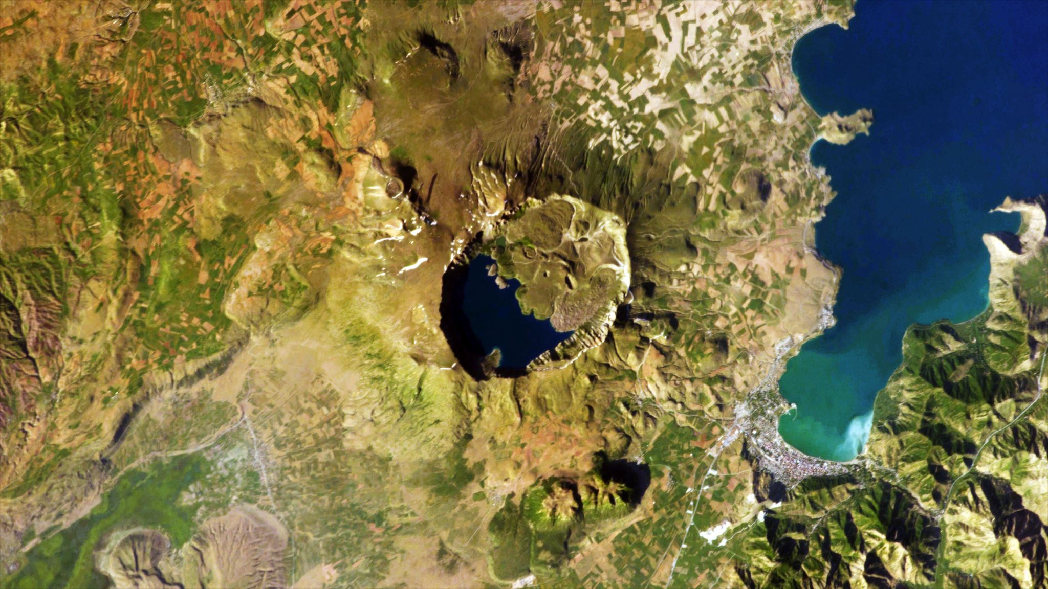
Lake Van is the largest lake in the Armenian highlands (this is called the Eastern Turkey High Plateau in Turkey, but it extends across geographical borders) that make up the border region with Iraq and Armenia. It is also the largest lake in Turkey. Lake Van is both tectonic and volcanic. It is entirely tectonic: the lake originated as a subsidence basin. There is no outlet, so that water collects from streams but can’t escape. This causes an extreme environment: the water is alkaline with a pH approaching 10, with strongly fluctuating lake levels. But in the past there was an outlet. It was blocked by an eruption from Mount Nemrut, west of the lake. Thus, this tectonic lake also has a volcanic origin.

Mount Nemrut
Look for Mount Nemrut, and it does not look impressive. Another volcano north of the lake, Mount Süphan, looks far more impressive, and is in fact the second tallest volcano in Turkey, after Ararat. But it plays no role here. Perhaps Süphan deserves its own post. Mount Nemrut is our villain. It rises as a flat-topped block about 1 km above the surrounding fields. (This is a highland, and the fields themselves are around a mile above sea level. Expect cold and snowy winters.) From below, it does not look particularly volcanic. To see the real thing, you need to look from above.
The flat top is in reality a large caldera which shows beautifully in satellite images. It is near-circular, and 7 km across. A large VEI-7 eruption from here (58 km3 of ignimbrites) formed a 60-km long lava flow, which dammed Lake Van. This plinian eruption collapsed the mountain and formed its 50 km2 circular caldera, 270,000 years ago. Nemrut remains active, with three reported eruptions (all small) over the past millennium, the most recent one in April 1692.
Mount Nemrut lies beyond the end of the Varto Fault Zone. there is no direct connection, even though the line of the fault points at it. But there is a second, extinct caldera along the fault, called Bingöl (or Varto) caldera, some 20 kilometers southeast of the triple point. This 10-km wide caldera is named after the town of that name. This town in a previous era was known under third name, as Karliova. And so we come back to the North Anatolian Fault, which begins at the Karliova triple junction. The fault not only shares the name of the start of its journey with a town, but also with its caldera. And it has taken more than just the name.
The 3 million year old Bingöl caldera is dissected by the Varto fault. The caldera sits north of the fault. But is only half a caldera: the Bingöl caldera is also known as a half-caldera. (It is more like 2/3rd, though.) Where is the other half (or third)? A match was found with the Turna mountains, 50 km away on the other side of the fault. This is another case of a volcano on the move. (It is another similarity with the San Andreas.) (I should say that this is not universally accepted. It has also been suggested that they are two different volcanoes which were active at the same time in each other’s vicinity.)
The Turna mountains, though, are not on the Varto fault. They are on the other side of the triple junction, on the North Anatolian Fault. And so not only did the North Anatolian Fault take the name of the town for its triple junction, it also took half its volcano. What a fault.

https://orbi.uliege.be/bitstream/2268/77782/1/GSL08_HubertFerrari_NAFTripleJunction.pdf
Albert, November 2020


Funny, I started looking Into Turkey’s following last weeks earthquake near Izmir and here it is! Neatly sculpted together! Thank you Albert!
I was actually already writing this post when the Izmir quake happened. This post was already planned for this week. Izmir of course is not on this fault (unlike Izmit) and is a much harder region to interpret.
Very detailed and fascinating! I don’t think I’ll be holidaying in Turkey any time soon. Thank you for this article!
Izmir was quite nice when I was there (in another era). On weekends the waterfront turns into a sort of promenade with nut vendors and locals visiting each other. At the time, there was a Pizza Hut™ on one end near the landing and had the most exquisite spice in the usual crushed pepper shaker. Made the Pizza taste like a dream. Dunno what spice it was, but it went very well with a stereotypical pepperoni pizza.
Advice:
1) Stay clear of police officers and banks. They tend to be the target of “upset people” and gas-bottle bombs.
2) Do not under any circumstance climb on a statue of a guy on a horse. This is likely a statue of Atatürk. (National Hero)
Any other specific precautions can be determined from your local embassy office there.
Don’t go, threat of kidnapping to westerners, especially those from countries that support Greece!
I read that volcanism is driven by a broken off slab from the subduction of the tethys ocean and also the action of stretched thin crust in the south east where the anatolian plate is trying to escape to the west (while being squeezed). Whatever the cause, Nemrut and it’s neighbours are certainly impressive, and fortunately not too near civilisations.
Also curios on Turkey after last weeks quake. Thanks for this interesting review! By the way. Have a memory that someone wrote a VC post on faults and quakqe hazard in the Marmara lake. Geo Lurk??
You have a good memory! Lurking pointed us in the right direction: https://www.volcanocafe.org/iceland-going-boom/#comment-13772
Spoiler alert: My comment at the time was mostly me raving about Wells-Coppersmith. It’s a paper that gives a really nice way to numerically estimate quake effects. At the link you’ll find me yammering about quake effects and a plot of MMI vs range from a generic Mag 7.2 in a non California geology. (In California the quake intensity drops off faster with distance due to the sizable quantity of fault systems in the region)
It’s like trying to shift a box of gravel around.
The region does seem to be relevant to how destructive a fault can be.
I have been digging around for some information on volcanoes in Turkey before, but I haven’t found it easy to come by. The country sure has its fair share of them, even including a few shield volcanoes. There’s probably more than enough there to warrant an entire post…
(long time no comment so I guess this one will end in the dungeon)
You avoided the dungeon.. It is hard to find in-depth information on Turkey’s volcanoes. We would welcome a post!
The varves (annual sediment layers) in Lake Van deserve a mention. Intercalated ash layers from eruptions of Nemrut Dag give a record (almost year-specific) going back to the start of the Holocene. It’s a bit awkward for American ‘creationists’ since by their thinking, many eruptions must have pre-dated the origin of the Universe.
I did not come across that. Do you have a reference for this? I’d like to read.
As for creationist, I decided long ago that it does not matter to me, and I am happy to accept that people hold their opinions. When science is being falsified to create an argument, that is a problem. But in most cases, a bit of acceptance goes a long way. I am not in favour of ridiculing people. Dawkins did seem too extreme. I find Gould’s magesteria a better starting point.
Excellent information about a fascinating major fault and tectonic setting. As a geologist who evaluated earthquake hazards for many decades, and a resident of the San Francisco region of California, I especially appreciate the comparisons to the San Andreas fault zone. The recurrence intervals for North Anatolian fault earthquakes are crazy short! Thanks for this post.
This much appreciated comment was held for approval but the system. This happens to all first-time commenters. Future comments should appear without delay – admin
Thank you. If you would like to write something for us about your work as hazard evaluations, we would be very interested in it! I don’t know why Anatolia has many more large earthquakes. There may be more segments as the fault is a bit younger. The San Andreas may have a larger segment of creep. And the rocks may be colder in Turkey. But these are guesses.
Thanks for this reply. The reasons for the short recurrence intervals you list are good ones. I don’t cross paths too often with my former geology colleagues, but I might be able to find out more possibilities. The hazard evaluation work I did was typically for large and low risk/high consequences facilities such as dams and power plants — and usually near less active faults. (I still marvel at the ignorance/arrogance of designers of a nuclear power plant at Bodega Bay north of San Francisco — construction was started with an excavation exactly on a trace of the San Andreas (now called “Hole in the Head”) — but that was back in the 1960s!)
Excellent and fascinating article! I’ve always wondered about the large number of earthquakes in Turkey and the presence of the volcanoes (Ararat in particular) in the eastern side of the country.
I’ve noticed a warning of an imminent eruption of Mt Merapi on Java. Is there a link for more information, and does anyone have more knowledge of this possible event ?
Thanks
Pysorg has an article about it from June 2020. https://phys.org/news/2020-06-indonesia-mt-merapi-erupts-spewing.html
Since reawakening, Merapi is a pretty active player.
Additionally, The Jakarta Post echoes that warning.
https://www.thejakartapost.com/news/2020/11/05/mount-merapi-may-soon-erupt-authorities-say-as-volcanos-alert-level-raised.html
Technically, Merapi is in almost continuous eruption -sometimes for decades on end- with magma arriving to add to the volume of the summit dome. it’s only when growth starts to threaten the outer slopes. either by explosive collapse or extrusion of a lava flow (more rarely) that the alert warnings start ramping up
Nice article Albert. Ive been to Kusadasi. Ephesus and Izmir. The latter a modern city . But the surrounding areas shows many rock layers which look beautiful but are severely buckled. Red and yellow in a S shape. Kusadasi is a major tourist area with long sandy beaches. I do hope Ephesus is not in ruins again.
Some interesting talks on the geology of the Mediterranean including Anatolia can be found here:
https://www.youtube.com/c/egu/videos
Look for GIFT2017
Thank you.
IMHO, the ‘North Anatolian’ is the ‘monster under the bed’ of the Eastern Med. Should it kick Istanbul, I’d expect the ‘modern infrastructure’ bridges and tunnels to survive, given they’ve been built to do so. Most of the ‘old-style’ buildings are doomed, per Skopje, Yugoslavia. (*) Sadly, as we saw in Izmit, and we’ve just seen in Ismir, many ‘modern’ apartments were not ‘built to code’, or extra floors added, or their materials skimped, so will come down like dominoes or skittles with vast toll.
Plus, a bad hit to Istanbul may throw entire region into chaos, potentially killing more people in following decade than the quake itself….
*) Our family drove/camped to Greece back in the 60s, saw what became of Skopje, Yugoslavia. Weep…
Slightly OT but apparently we had a small earthquake here earlier. The interesting (to me at least) thing is I live east of Providence RI in Seekonk Ma and the epicenter was only about 25 miles to my SSE. Didn’t think there were any faults that close to me, although I do know there are some in western MA.
Not unheard of. Ma has had some 400 felt earthquakes since settlement. Most are associated with a large event in the 18th century which was in excess of M6 and caused damage in Boston. It would be a shock if that repeated. Even the Boston basin is bordered by a fault.
There is some activity in the south of RI as well. Quoting neserc:
“Rhode Island has had a number of small and moderate earthquakes centered within the state, primarily in its southern part, and the state has been shaken strong by several earthquakes that were centered beyond its boundaries. Throughout 2016, a total of 34 felt earthquakes have been centered in Rhode Island since the first known shock on August 25, 1776. Of these felt earthquakes, only one caused some slight damage. That event took place at 12:20 pm on June 10, 1951 and had a magnitude of 4.6. The earthquake was centered a few miles south of Westerly, RI, and it was felt across Connecticut, Rhode Island and the south coast of Massachusetts to Cape Cod. “
Would this activity be related to flexure due isostatic rebound ? Parts of NW UK get a disconcerting number of minor ‘temblors’ as zone is the ‘fulcrum’ between rebounding North and sinking South.
Upside, region has nothing to fear from 2nd-order isostatic effects that are eg lowering London into Thames Estuary. We’ve just ‘common-or-garden’, CO2-driven sea-level rise on a mostly low, ‘soft’ coast with big tidal range and storm-facing shores. Much was ‘fenny-land’ until drained, may return to such… (*)
Down-side, as Cuadrilla found, is that you try gas-fracking such geology, you’ll kick a lot of small but twitchy local faults. Ultimately, they despaired of their test-wells’ many temblor time-outs and, to delight and relief of locals, declined to renew their exploration licence…
(*) Disclaimer: I am safely ‘situate’ on a sandstone ridge, its reassuring Medieval dry-foot suffix ‘On The Hill’. This would become isthmus, then island should sea-level surge and the dune-lines etc fail…
Just for some Sunday night silly trivia, the Lake Char fault in Albert’s map is named after Lake Chargoggagoggmanchauggagoggchaubunagungamaugg in southern Massachusetts. How’s that for a mouthful.
Any translation?
Actually, yes.
“The lake received its full name once the English colonists arrived in the area. Prior to the colonists’ arrival, the lake was known as “Chaubunagungamaugg,” meaning “fishing place at the boundary.” When colonists began using the lake as a fishing and meeting spot as well, the name expanded to its full Chargoggagoggmanchauggagoggchaubunagungamaugg,” meaning “English knifemen and Nipmuck Indians at the boundary or neutral fishing place.”
https://www.atlasobscura.com/places/lake-chargoggagoggmanchauggagoggchaubunagungamaugg
Learned that in may Appalachian Geology class over 30 years ago. Never thought it would ever come up again. 🙂
in my…
The GPS on lake Grim (Grimsvotn) has come back to life.
I had almost given up hope on that one. Sadly it went silent again at 3am, together with seismometer data. Probably the connection to the station was lost. Maybe the replaced power supply is causing problems.
They are going to give it a good send off. Taking bets to see how high it goes. Loser to retrieve it
Wow this probably one of the best articles i’ve read in any subject ever. Congrulations.
I live in Istanbul, and in Atakoy. It is said that Atakoy is very prone to earthquake but our buildings are very strong. I hope nothing happens :/
Thanks a lot for the article, Mr. Albert.
This was held for approval by the system: this always happens for first-time commenters. Any future comments should appear without delay – admin
Rare sudden deflation of Mauna Loa.
I was looking at the GPS PAT2 and it seems that this is the only time in the past 10 years where Mauna Loa contracted so much, so fast. It is still a very small deformation but it is somewhat intriguing
I did point this out a few weeks ago because it coincides exactly with the recent earthquake swarm next to Kilauea. The plot at Kilauea mostly didnt change but there was a slight jump at the same time, maybe there was a slight release of pressure at Mauna Loa as the flank slid very slightly, which pushed into Kilauea. There has been no increase in seismicity at Mauna Loa at all recently so its not any sort of intrusion into a new area at least.
I dont know what causes the swarms at Ka’oiki though, they are probably more related to Kilauea out of proximity and some of them were followed by intrusions so probably are related to pressure. All the examples in the recent address by HVO were swarms at Ka’oiki that happened during Pu’u O’o so the ones not followed by intrusions maybe just erupted there instead and appeared to have no impact. The deep chamber of Kilauea is still fast inflating maybe that is what caused it, but in that case it doesnt explain the Mauna Loa signal…
It followed the earthquake swarm above Kilauea. I think it is settling of the flank.
A M 6 earthquake took place at the submarine volcano Orca Seamount 5 days ago, in Antarctica.:
https://www.volcanodiscovery.com/earthquakes/quake-info/5977502/mag5quake-Nov-6-2020-South-Shetland-Islands-Antarctica.html
It’s part of a, probably volcano-tectonic, swarm that started in August at Orca Volcano. There is some interesting stuff going on there, but sadly it’s remote and deep underwater. It could be a rifting event of the Bransfield Rift.
https://blogs.egu.eu/divisions/sm/2020/10/15/earthquake-of-the-month-bengkulu-indonesia-m-6-8-6-9-2/
New post is up. Growing Iceland
https://www.volcanocafe.org/icelands-eruptions-since-1900/