
The bird struts across the henge as if its owns the place. It is quite a sight itself: large, confident, and long extinct. It was re-introduced here a decade ago but is rarely seen. Great bustards are shy, befitting the fact that they look very edible. This one, for a strange reason, had lost its fear of humans and it walks right up to us to have a better look. Its stony-coloured feathers mirror the stones behind it. The unexpected experience complements the historic atmosphere of Stonehenge. The many tourists walk in a large circle around the ancient, famous monument. Only the bustard is allowed inside the walk way. It really does own the stones.

Great Bustard at Stonehenge (July 2019)
After 5000 years, Stonehenge still fascinates. The massive stone ring stands in sharp contrast against the surrounding fields. Over time (lots of it), many of the stones have fallen and what now remains is an irregular echo of the original. Especially the innermost area is a jumble of fallen stones. Obviously, the British of 4000 years ago, just as their modern counterparts, did not believe in either building standards or maintenance. But the many tourists are captivated, pointing out detail to each other in a variety of languages, or posing for a selfie with the ancient stones. The path takes us around the stones but getting in among the stones is only for the privileged few, and strictly outside of normal opening hours. Too many people have tried to carve their initials into the stones: access has had to be limited just for safeguarding. If it has this effect over us, how much more would the visual power have been when the monument was at its prime? Stonehenge always was a magnet for the imagination. The site was never inhabited; instead people lived some miles away. There were no defensive fortifications: it never needed them. Just as China subsumed its invaders, so Stonehenge possessed each new possessor. Even the Romans adopted the site for their rituals.
But Stonehenge was always a work in progress, and was never finished. Generation after generation shaped it according to the new needs and fashion. It started out as a circular bank, which was build between 3000 and 2920 BC and which is still visible in the landscape. The material for the bank was dug out from the chalk underneath. This was a common technique, but normally the ditch was on the inside of the bank. At Stonehenge the ditch where the chalk was dug out was on the outside, an arrangement more commonly found in ancient meeting places or burial grounds. At the time the circle must have gleamed white in the landscape, visible from far away. Even at that time, this was a ceremonial site, not a fortification or habitation. There were circles of wooden poles inside the bank: the holes in the chalk are still there. (Others have suggested that even in the earliest times, the holes were for standing stones rather than wooden poles.)
A major upgrade followed 400 years later, when the inner area of standing stones was added. This included the ring (number 12 on the image below) of 30 standing stones, linked by the cross bars. 17 of these stones remain standing (the rest are fallen, broken, and some are completely missing!), and only 6 of the lintels are still in place. The ring is most complete on the northeast side. On the opposite side there is much less left. That is more than just the workings of time. The stones on the northeast side were well prepared, and the stone surfaces were worked to be flat. Even the lintels were shaped slightly curved, to follow the circle. The stones on the other side are much less regular, and one of the remaining stones here is much smaller than the others, and is too small to have carried a lintel. Perhaps the stones on this side fell more easily because they had not been put up with as much care! The outer ring may not even have been complete.
The care put into the stone work on the northeastern side shows that Stonehenge was build to be viewed from that direction, and in fact the ancient path towards it runs here. This path lines up with the solstice: people walking towards Stonehenge at mid-winter would have seen the sun set directly behind the monument. It works both ways: looking from within the stones along the path, it lines up with the rising sun of the summer solstice. But the asymmetry shows that Stonehenge was first designed for the winter solstice.


Just inside the circle of large stones, a second circle was build (it is number 13 on the drawing). This was made of much smaller stones. The inner circle contained perhaps 60 stones. They were not worked as well, Strangely the workings on two of these stones show that they had been used as lintels at an earlier point in time, but were re-used as standing stones in the circle. Only a few of these stones survive. It seems that originally, they may have been arranged in a double arc, and later (around 2200 BC) were relocated into a complete circle.
More stones were added inside the circle, probably as part of the major development of around 2500 BC. These stones were much taller, and they formed a horseshoe arrangement. The horseshoe consisted of five pairs of stones with a lintel, graded as to their height along the horseshoe (number 14 on the image). Each pair is called a trilithon. Three of these pairs still stand (one of these had fallen but was re-erected in the 1950’s). The largest of the pairs has suffered a collapse where one side and the lintel fell, but the other stone still stands: it is over 7 meters tall. There are axe blade marks on these stones, but this happened 700 years later. The horsehoe must have been erected at the same time or before the outer ring of stones was put up, as the gaps in the ring would be too small for the inner stones to pass through.
Inside this horsehoe was a second horseshoe, or perhaps semi-oval, made of much smaller pillars. As in the trilithons, these stones were graded in height with the tallest on the closed side of the horseshoe. These stones are the most carefully worked of all stones at Stonehenge. They did not have lintels, but it seems some had been attached to lintels before, at another location.
There are other stones at Stonehenge, which are not part of this general structure. One of these is at the centre of the horsehoe, but it is partly buried underneath the fallen stone and lintel of the largest trilithon and can’t be seen from the tourist trail. It is called the altar stone, but this is a made-up name as we have no idea what it was for. It was already lying on the ground when the trilithon fell on it. It may originally have stood upright, as do all other stones, but this is disputed. It was in some ways the centre piece of Stonehenge. The inner faces of the trilithons, facing the altar stone, are finely worked while the outer faces are more rough: this shows the importance of the central area. There are other individual stones scattered around the site, mostly close to the old circular bank: these include the evocatively (but incorrectly) named slaughter stone.
The current placements of the stones date from around 2200 BC. The most recent publications suggest that between 3000BC and 2200 BC there were 5 separate phases of building and rebuilding. After this, the re-workings ceased apart from the addition of two other rings of holes which apparently were never used. Up to that time, each generation left its mark.
An idealized view of Stonehenge is shown in the drawings, which show the closed ring, the five trilithons making up the horsehoe, the ring of smaller stones inside the closed ring and the smaller stones inside the horsehoe (click on the images to view in higher resolution). All these aspects were present, but Stonehenge never looked like this. This always was a building site.


Farmers finally moved in on the surrounding fields; by this time Stonehenge appeared to have fallen out of use. The Romans re-invigorated the site but they too were temporary. The first written descriptions of the ‘doorways’ appeared around 1130 AD. Archaeologist arrived a few hundred years ago and started digging around the site and speculated about how it was build and why. They were followed by the tourists, and finally by the druids, a modern re-invention of a pre-roman cult which had very little to do with Stonehenge. Everyone adopted Stonehenge to their own purposes. It still holds that power over us.
Monuments need maintenance. Since its development ended, Stonehenge has suffered a slow decay. A standing stone can be a liability: it can be prone to toppling. At least two stones have fallen in the past few hundred years. Stones may have disappeared entirely, perhaps use by a local farmer in need of of some stone. There are more holes on the site than there are stones. However, stones may also have occupied more than one hole, so that we don’t know accurately how much has been lost.
The site was last sold in 1915: both the head of the family that owned it and the inheritor had died on the fields of France. A local farmer bought it on impulse, but some years later donated the site to the nation. It earned him a well-deserved knighthood. Nowadays, Stonehenge attract a million visitors per year, each involuntarily donating their 21 pounds to English Heritage. The ticket buys you entrance to a fairly sparse exhibition centre, a model village, a bus to the site itself (or you can walk – it is the same price and you get to see more) – and the most monumental views in the world. Spend 6 pounds more (highly recommended) and you get an excellent booklet about Stonehenge.
Stonehenge is a monumental marvel, and is recognized as a world heritage site. But the stones are themselves also of interest. There are three main types: the chalk of the wall, the sandstone of the large stones, and the bluestone of the smaller stones. The altar stone is a sole example of a fourth type, a greensandstone. All have history that goes far beyond the human presence. One type even holds a volcanic heritage. There is a story here – and it stretches across the most recent supercontinent on Earth.
Chalk
Stonehenge is build on chalk. Chalk underlies much of southern England, surfacing in various places, most spectacularly on the white cliffs of Dover. On the map below, the surface chalk is shown as lime green, a nominatively suitable colour. Around London a basin formed and here sediment has covered the chalk. Of course Dover is not the termination of the chalk, but is just an interruption. The chalk continues in France.

The Latin word for chalk is creta, and this word gives a clue to its age. Indeed, the local chalk formed in the Cretaceous, 80-100 million years ago, when a tropical sea covered much of Europe. The sea was full of cocoliths, minute marine algae with shells; these shells dropped to the sea floor and formed the chalk. The chalk consists of carbonate, and the whiteness shows that the water was crystal clear. In the chalk one can see thin layers of chert and flint, which are especially clear at Dover. This is quartz. Typically, these layers indicate where a layer of mud had formed. The mud came from organisms in the sea water such as diatoms, which secreted silica, and the silica formed the flints.

The world during the cretaceous
But why was there so much water over Europe? This was a time of high sea level: the sea had come in and covered all of the continental shelf and quite a bit of the coastal areas. Sea level may have been 200 meters higher than now. It was a warm period without sea ice, and the warm water expanded and rose. The sea had become unstoppable. But there was a second reason. This was a time of rifting. The supercontinent of Pangaea was breaking up, and the Atlantic Ocean was forming. The rifts were busily forming new sea floor, and did so at a high rate. But this sea floor consisted of warm rock, replacing the cold ocean crust which was subducting elsewhere to make space for the new crust. Warm rocks expand, are lighter, and float higher. The new sea floor was therefore much less deep than the old crust. The water had nowhere else to go but up.
The good times (for sea creatures) did not last. The new crust cooled and the sea level dropped. The fragmented continents drifted apart, but elsewhere began to collide and push up new mountains. One of these fragments was Italy, which in a moment of careless drifting crashed and caused the Alps. As a distant ripple of the Italian collision, the British-French chalk region was also pushed up. The elevation of this ripple reached as high as 1 kilometer in the Weald. The peak elevation eroded and this removed the chalk in the Weald, whilst elsewhere the chalk survived, now well above sea level.
The chalk has also been subject to the stress of the ice age. The glaciers left deep striations in the chalk around Stonehenge, running roughly southwest-northeast. They are nowadays difficult to see, but these striations may have been a reason to build Stonehenge here, as they approximately lined up with the solstice.
Chalk is a soft stone. The earliest bank of Stonehenge was made from chalk which was dug out using deer antlers. Here, unusually, bone is harder than stone. Try to imagine what it would be like to dig with antlers, and it becomes understandable that the ditch eventually became quite irregular.
Sarsen sandstone
The largest stones of Stonehenge are so-called sarsen stones. These were used for the outer ring and for the trilithons of the horsehoe. The individual stones elsewhere at Stonehenge also are sarsen stones. In total, 53 sarsen stones remain, out of perhaps 80 which were present in the heyday of the original monument. The stones are huge: the weights range from 4 to 35 tons each.
Sarsen stones are a sandstone. They are a silcrete, formed when sand became cemented by silica. It is similar to concrete, and like concrete it forms where there is an abundance of water. The silica is dissolved in the water, and is redeposited when the water dries out. Sarsen stones are found across much of southern England. They formed during a time of tropical conditions, after the sea had withdrawn, between 23 and 65 million years ago. Because of the need for water, this probably happened along water courses. Even nowadays, the sarsen stones can be found lying on the ground in many places. The stone is hard and resistant to erosion. Much of the stone has been used for building. The sandstone is a poor material for houses (it lets too much water in) but it was used for paving, stepping stones, and graveyards.

Sarsen stones in Wiltshire https://www.wiltshiregeologygroup.org.uk/geology/tertiary/
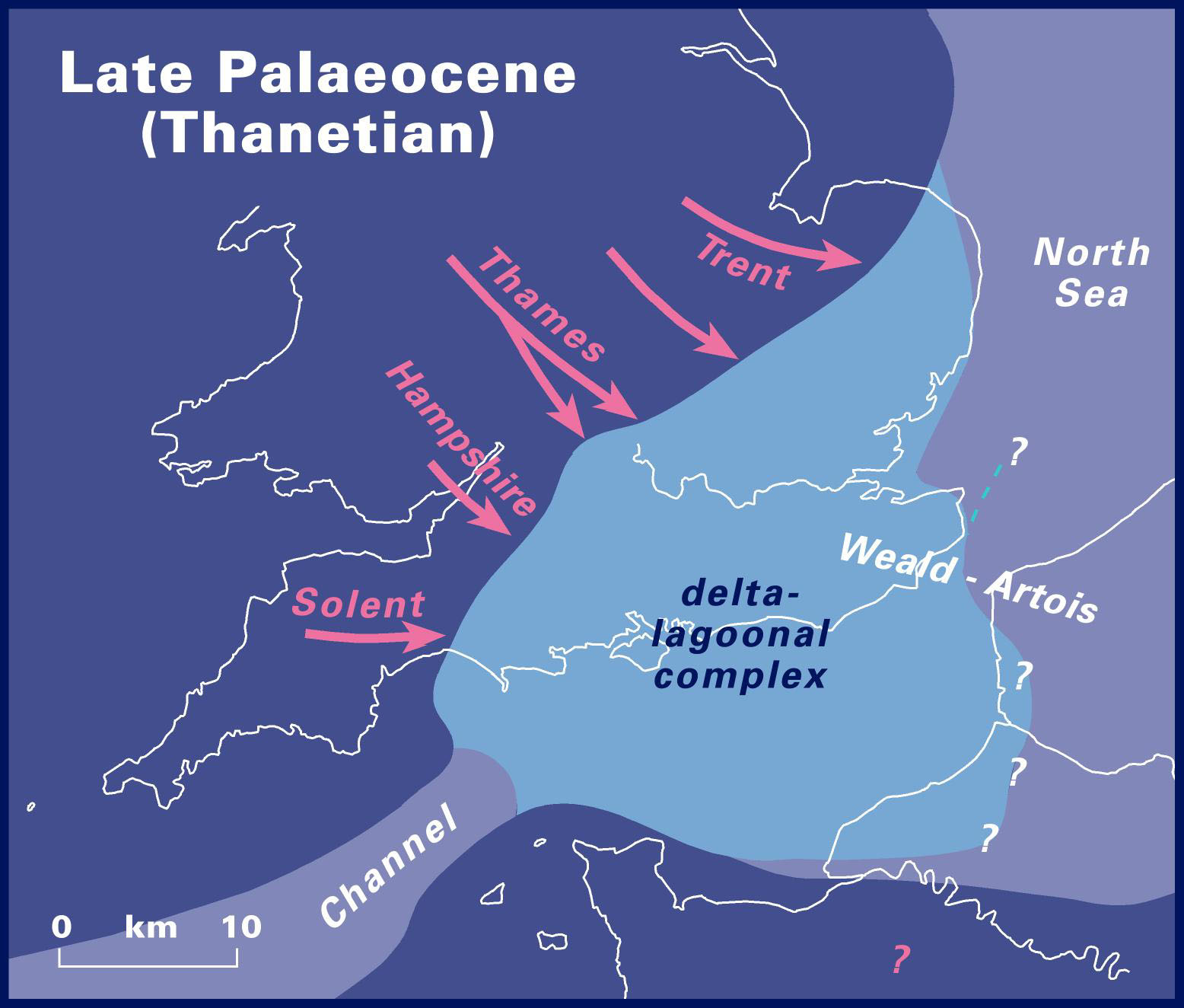
So the sarsen stones are a memory of an age where southern England was a fluctuating mix of sand and water. After the Cretaceous, the area to the west and northwest, from Brittany to Wales, was uplifted. There was a sea arm south of England and the North Sea basin already existed, both associated with the continuing formation of the Atlantic ocean. In between was a delta area which was at times submerged under a shallow sea. Rivers brought the eroded material to the south and deposited the sand. Later, the sand became cemented by silica. It was this combination that formed the sarsens. Some argued that the sarsen stone formed a cap over much of the area, but it is perhaps more likely that it mainly formed along the river courses.
Sarsen source

A small surviving sarsen on Clatford Down beside Totterdown Wood. Source: The sarsen stones of Stonehenge, Mike Pearson. Proceedings of the Geologists’ Association Volume 127, 2016, Pages 363-369. https://www.sciencedirect.com/science/article/abs/pii/S0016787815000899
There are sarsen stones near Stonehenge but they are small and are unlike the ones used in its structure. Already in the 18th century, the area around Marlborough was identified as the most likely origin of the Stonehenge sarsens. It is about 30 km north of Stonehenge. The sarsen stones here are sufficiently large and thick (1.5 meters) to fit the Stonehenge requirement.
The most likely source is at the top of the ‘downs’ (hills) above Clatford where a sarsen quarry may have existed. The stones here were tabular and much better shaped than those in the valley. Old reports states that near Clatford, there once were 12 stones lying which had been partly prepared, and were in the right location for transport to Stonehenge. That site no longer exists: it is now covered by the A4 road. Stukely, in the 18th century, wrote ‘Perhaps those were stones going to Stonehenge for they seem to have been brought from the top of the hill northward thence where upon a long ridge there are many stones of Vast bulk besides what lye in all the valleys round in great quantity.’ The ridge is near Totterdown Wood. But by 1812, the sarsen stones here had been destroyed for building works.
Note added July 2020: chemical analysis has traced the origin to near Clatford. The suggested site is Westwood, just south of the A4 and about 3 km south from the source suggested above. This confirms the general area. The exact location of course depends on there being remaining stones to test, which is the case in Westwood but not at the old site.
http://www.sarsen.org/2016/01/mpp-on-sarsen-stones-of-stonehenge.html
The stones were transported to Stonehenge where the dressing of the stones took place. A working area has been located about 100 meters north of Stonehenge, next to the avenue. This shows that the stones came from the north. Stone chips show that the stones were worked in this area, before being erected.
The solitary stones are Stonehenge are also sarsen stones, which unlike the main monument were not dressed. Among these is the slaughter stone, which lies on the ground next to the tourist trail. It is a rough sarsen stone. When it rains, water collects in the hollows and can become red-tainted, giving the impression of blood – thus the name. Of course, it is as historically incorrect as the Stonehenge druids. The stone originally stood upright: the hole where it resided is still there. There is a second hole, and there may once have been two stones (or the stone was moved, or the first hole was dug but rejected by the architect: archaeology requires a lot of conjecture). The sarsen stones contain whatever elements and minerals were present in the sand and water from which they formed. Many contain some iron, and this is what stains the water. There is no connection to blood, unless one considers that blood also gets its red colour from oxidized iron!
Greensand stone
The altar stone differs from all other stones at Stonehenge. It too is a sandstone, but it is a 6-ton greenish sandstone with mica. As it is buried underneath the huge fallen sarsen in the heart of the monument, no real excavation has been possible. However, the difference with the other stones is clear. There is no similar natural stone in the general area and it must have come from a considerable distance.
The precise origin is not known, but the nearest similar stone is found in the Senni formation. This is a layer of sandstone in south Wales, running in a narrow strip from Llanelli to Herefordshire. This puts the source of the altar stone in the Brecon Beacons or the Black Mountains. The Senni formation dates to 400 million years ago, making the altar stone much older than the sarsen stones which now cover it.
In fact, the Devonian deposits of which the senni formation is part, are among the oldest parts of England and Wales which formed above water. (Scotland has much older rocks, though). They formed in a similar way to the sarsens, along long river beds which deposited sand. The sand was became cemented in places, but here the cementing was done by calcium rather than silica: this is called calcrete.
Devonian
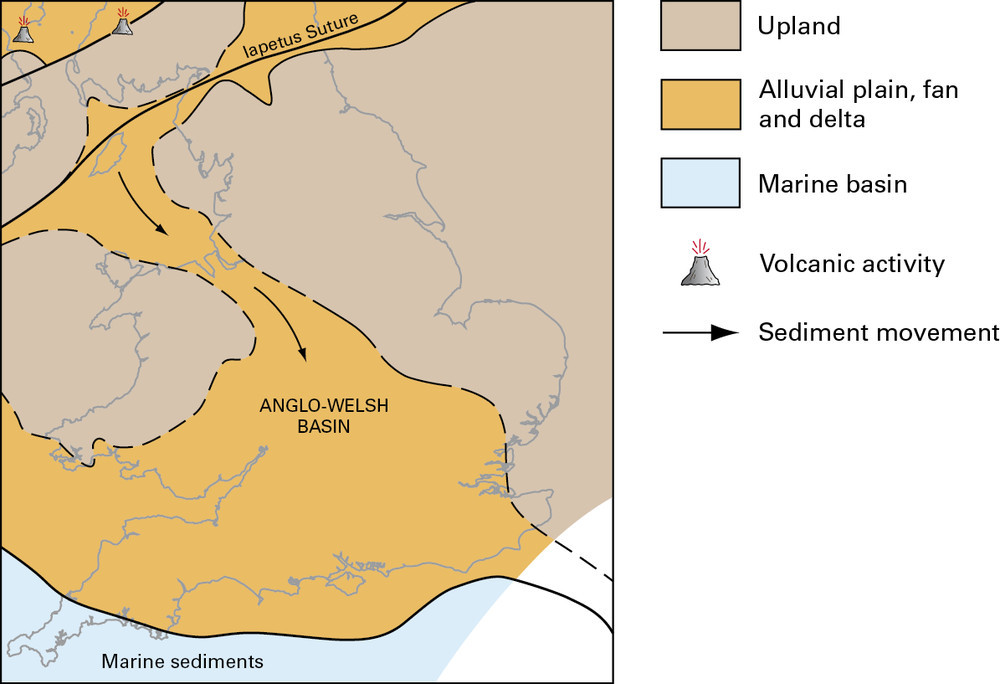
The image shows the lay of the land in the early Devonian. This was just after the closure of an ancient ocean, the Iapetus. The Caledonian mountains formed along the closure: they can still be seen in Scotland, the Lake district and North Wales. South of the suture was a flat, wide delta created by sediment from the mountain range. The senni formation is a layer within this delta, which is exposed in places south Wales.
So we know the approximate area the altar stone came from but we cannot be fully certain of the precise origin. We do not have certified fragments of the stone available for analysis. What we have are chipped fragments taken from the location where the stones were worked, and although the chips we have are likely to come from the altar stone, this is not proven.
There is some colour confusion apparent in the naming. The altar stone is a greensand stone, coloured by glauconite. But the Senni bed belongs to the old red sandstone formation. To make things worse, the generic name for Welsh stones and Stonehenge is bluestone. This humble, buried centre piece is red, green and blue all at the same time.
Bluestones and the Stonehenge volcanics
The other stones of Stonehenge are found in the inner circle and the inner horsehoe. They are much smaller, and are called the bluestones, a colour which is only (just) seen when they are wet. There are much bluer rocks in the UK, especially the blue liam of Lyme Regis on the Jurassic Coast. But you can’t make monuments from them. Instead, the Stonehenge builders sourced the most impressive rocks they could find. But from where?
Preseli hills
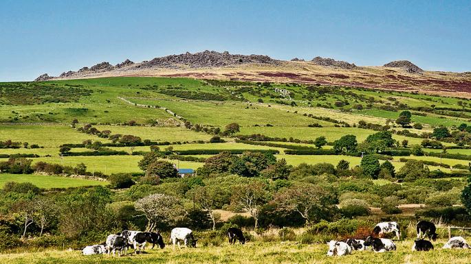
The answer to that has been known since quite a long time. The type of stone is unique to the Preseli Hills, an area in Pembrokeshire on the west coast of Wales. It is a range of hills, up to 500 meters high, which dominate the lower land around them. There are burial sites, hill forts, bank and circles on the hills: it was a popular place in the neolithic. An ancient pathway, called the golden road, runs over the ridge of the hills. The hills are some 200 kilometers from Stonehenge.
Pearson et al, 2015, Antiquity, 89, 1331 https://www.cambridge.org/core/journals/antiquity/article/craig-rhosyfelin-a-welsh-bluestone-megalith-quarry-for-stonehenge/D1E66A287D494205D22881CBF1F6DDE8
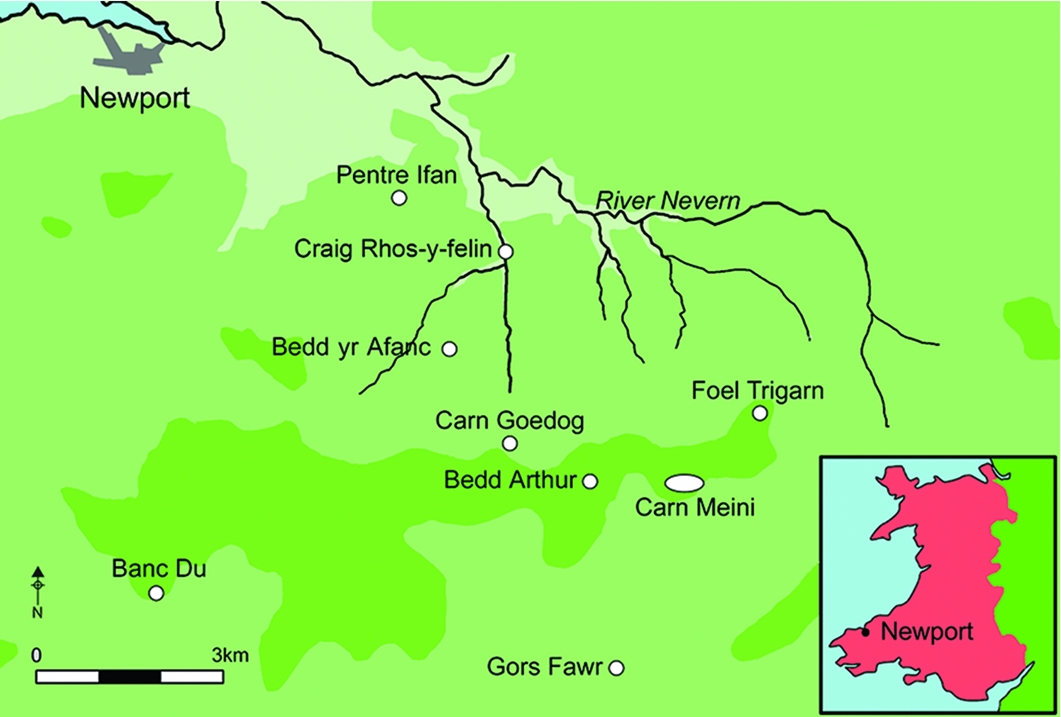
There are several potential neolithic quarries here from where the stones could have been taken. For a long time, the southern side of the hills was favoured for the origin of the bluestones. That was in part because of the possibility of moving the stones by sea. In recent years, attention has shifted to the northern side of the hills, where two specific sites were identified, the outcrops of Carn Goedog and Craig Rhos-y-felin. The outcroppings are a few kilometers apart. In both places, the rock cracks naturally to form large slabs wich are easily removed from the mountain. Carbon dating on the sites shows that quarrying took place around 3200-3400 BC, which is a bit older than Stonehenge.

Archaeological excavation at Craig Rhos-y-felin
The validity of this source is still discussed, but it seems clear that the stones came either from here or from a very nearby region. However, although from such a specific location, the bluestones are not uniform in composition. The main type found among the fragments of bluestones scattered around Stonehenge is dolerite. Dolerite is an intrusive rock type: it forms when magma intrudes underground but solidifies in situ. However, fragments of rhyolite and tuffs have also been found.
The Preseli hills are Ordovician in age, around 450 million years old. At the time, this area was below water: the hills consists of marine mudstone. The magma intrusion happened a bit later. Erosion left the harder dolerite as outcrops above the softer mudstone. The sites identified above are for the dolerite bluestones, and these come from the intrusions.
During the Ordovician the Iapetus ocean still existed but it was already in the process of closing. Britain (without Scotland) was some 40 degrees south of the equator. Originally, it had been part of Gondwana, as a volcanic arc. During a rifting episode, the area broke off from Gondwana (an early brexit) and the microcontinent of Avalonia, including Britain, began to move north. To the northwest was the subduction zone that pulled Avalonia forward. On the far side of the closing ocean was Laurentia (effectively the early North America, including Scotland). To the northeast was another microcontinent, Baltica. The collisions followed in the Silurian, the period after the Ordovician. First, Avalonia joined America, and later both joined Baltica and Siberia. Now the northern continent of Laurasia had formed. After the Silurian came the Devonian, when the old red sandstone formed which gave rise to the Stonehenge altar stone. Some 300 million years ago, Gondwana caught up with escaped Britain, and the merger of Gondwana and Laurasia form the Pangea supercontinent. And much later, the break-up of Pangea led to the events that formed the chalk and the sarsen stones.
During the Ordovician, before the closure of the Iapetus, the area around Preseli was a back-arc basin, oceanic but without sea floor spreading. The rocks of Preseli were deposited in this basin. Other rocks of this age are found across West Wales and in the Lake District. The mixture of soft mudstone and harder rocks have left a dramatic landscape.
This story begins with the dolerite bluestones, but how about the rhyolite and tuff? Subduction is associated with volcanism. That happened here too in the Ordovician. Andesitic volcanoes formed: the eruptions formed the so-called Fishguard Volcanic Group. This was of course related to the dolerite: one formed below the surface, the other above it. The lava and tuff deposits are found especially on the eastern and northern side of the Preseli hills. Pillow lavas are common, showing that this was a marine basin. The Fishguard group has been dated to 460 million years ago, and this age agrees with those of crystals in the Stonehenge bluestone fragments. The Craig Rhos-y-felin quarry is within the region of the Fishguard volcanic deposits.
There is also evidence for a rhyolitic component to four of the Stonehenge bluestones. Rhyolitic rocks are found only in small area of basaltic pillow lavas. The precise origin is not known, but a relation to rhyolitic rocks exposed near Pont Saeson has been suggested. This is close to Craig Rhos-y-felin.

Transport
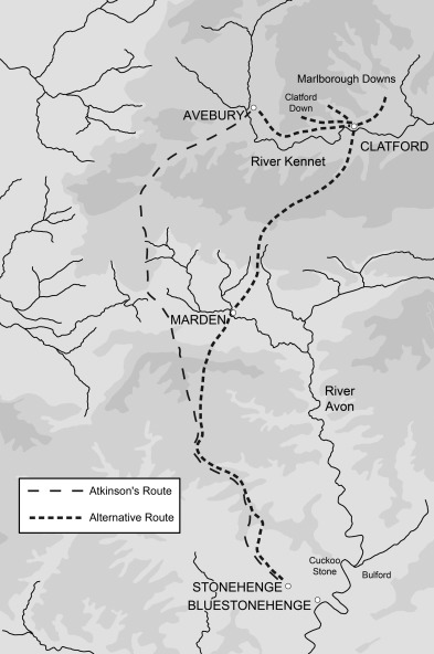
The route from here to Stonehenge must have gone over land as there are no harbours within reach of the northern slopes. The southern route is prohibited because of the steep ridge between the two sites and the sea. However, there is a fairly flat route from the north over land, which follows several river valleys. It does require that the river Severn was forded. The transport is now considered as quite doable for a group of determined people: the bluestones are much smaller than the sarsens, and typically weigh about 2 tons.

The overland route from Preseli through the river valleys. Insert from Pearson et al, 2015, Antiquity, 89, 1331 https://www.cambridge.org/core/journals/antiquity/article/craig-rhosyfelin-a-welsh-bluestone-megalith-quarry-for-stonehenge/D1E66A287D494205D22881CBF1F6DDE8
(It has also been suggested that the stones were carried to the Stonehenge area by the ice age, as erratics. This proposal suffers from a lack of evidence, and it has difficulty explaining why the ice took only stones from Preseli and took them only to the Salisbury plains 200 km away and nowhere else. Human transport seems far more likely.)
The bluestones appear to have been moved to Stonehenge quite early. Based on bluestone shards found nearby, it may been around 2900 BC. This is still several hundred years after the quarrying at Preseli took place. One suggestion is that the original Stonehenge monument was not at Stonehenge but in Wales, and that this older stone circle was moved en mass to a new location and a new use. This would explain the several hundred year delay. Why was this done is something we may never know. Was it a vanity project by a powerful leader? Such things are well known in England: the useless but celebrated monuments build by people with too much money are called follies.
The bluestones may thus have been the first stones to arrive at Stonehenge, when it transformed from a circular bank to something altogether more impressive. This would fit the suggestion that the holes inside the bank were not used for wooden poles, but for standing bluestones. They may have been the same stones, later re-used time and again during subsequent redesigns of the site. A 2-ton stone is easier to move, after all than a 20-ton one! The stones were not dressed in Wales: the shaping took place only at Stonehenge.
Stone of ages
The stones of Stonehenge are an eclectic mix. The oldest are twenty times as old as the youngest. All are somehow related to Pangaea, the most recent supercontinent to exist on Earth. The oldest rocks are associated with the collision of Avalonia with Laurentia, which was a crucial step in the formation of Pangaea. The chalk stone and the sarsens are associated with last stages of the break-up of the supercontinent, and the completion of the Atlantic ocean. Perhaps Stonehenge should be called The March (or Rise and Fall) of Pangaea. Humans did have to move the heavy rocks – but plate tectonics did much of the work for them.
Our time at Stonehenge has come to an end and we have to head back to begin the drive home. Joining the queue for the bus, we have a final look at the old ruin, and the circle of barrows on the surrounding ridges. Stonehenge is a very human monument. It is a ruin from our distant past. Once this was the place to be seen, or at least to be buried. In a way, it still is. So much effort has gone into building it, nameless people dragging many tons of stone across 200 kilometer of undulating, spectacular but dangerous countryside. They too were under the pull of Stonehenge. But it is more than just human history. Stonehenge is also the result of the blood, sweat and tears of the Earth itself. The stones that made Stonehenge once build a continent. Stonehenge is also a monument to the Earth itself. It really does bring the past to life, both human and geological. Even that great bustard is a memory of the past. Once it roamed the plains, and now it has come back from extinction to reclaim ownership. It too belongs to Stonehenge.
Albert, July 2019
(This post is closely related to a previous post on another stone monument in the UK: The stones of Calanais)


Fascinating! Thank you!
Always have been fascinated with both the reason for and the geology of the Stones.
also it show the importance of not doubting the “old one” mechanical and engineering skill.
No UFO occupants or “Chariots of the Gods” involved.
Here is a Wiki on the Stonehenge replica on the hills of the Wahington side of the Columbia.
https://en.wikipedia.org/wiki/Maryhill_Stonehenge
However the construction is concrete..
“Washington” Dammit.
Are you sure that ‘Wahington’ isn’t a freudian slip more accurately describing the population there?
I think today we really underestimate how a well organised society able to field 1000’s people can move (and make) massive stones. We see that in Easter Island, Egypt and pretty well anywhere there is a big enough society lasting for a few hundred years.
The other thing about the stone age in western europe is that sophisticated chambered tombs of the same design exist in both the Orkneys and southern spain and its likely the society was over a much bigger area than you might have expected.
Its also important to remember, as a reference point, that ALL the south american civilisations (inca , maya etc) were stone age. Its that level you need to consider when thinking of stonehenge and later. Remains are otherwise scarce because with a cool climate and plentiful timber they probably used wood which has long since vanaished.
This is very true. Stone age people had all of our intelligence (probably more as they needed to survive real life rather than computer games and gullability could be a killer) and were a lot stronger than we are. Shorter-lived as well, probably, so plenty of young people..
I grew up near Stanton Drew, so always had a facisnation with the Neolithic. As a small boy I got to ‘play’ at Stonehenge, no name carving, I promise. I remember hearing about a navy diver who said he saw cut stones just like the ones at Stonehenge on the bed of the Bristol Channel. They were destroyed during engineering work. Can’t find anything on the web about this but may have given weight to sea route theory if evidence was established. Avebury I also found to be more interesting to visit, I always take visitors to both.
http://www.cems.uwe.ac.uk/~lbull/stonehenge.html
west kennet and silbury mound are also required visits.
There was certainly one such stone on the bottom of the sea: https://www.theguardian.com/artanddesign/2003/feb/07/art.artsfeatures
Very little else is known although I also have heard these stories. There is no evidence though, and interest has waned as the overland route seemed to be more likely.
The link mentions the various alignments of Stonehenge. The midwinter ones are the most accurate. The alignment of the heel stone with the summer solstice is a bit off, if you take into account that 5000 years ago the sun did not rise at exactly the same point. It was usable for the summer (noting that the sun rises at almost the same point for several days) but the original design was for the mid-winter.
There may be lunar alignments as well but this is harder to prove. There are so many holes where poles or stones stand or stood, that there is a significant chance that an alignment is just a coincidence.
I think an underestimated capability of paleolithic (and perhaps earlier hominids) was travel by sea/river. Uniquely amongst apes we have the ‘drowning reflex’ where physiological changes take place when immersed in water. Our dexterity makes shellfish of all sorts a really easy prey and there are small hills of shells left by early man around the med. The western european civilisation I mention above makes a lot of sense is paleolithic man was also an accomplished coastal sailor.
So I go for a naval method of moving the stones.
That was certainly the favourite route until fairly recently, at least for the bluestones. (The sarsens could only have been transported overland.) The locations of the quarries caused a problem as the only useable harbour was on the other side of the hills, pretty much inaccessible without a journey that would not be much less than going directly to Stonehenge. So the land route became preferred after that. There is some evidence that there was a bluestone monument at the river Avon which runs near Stonehenge. It is called bluestonehenge, and it may indicate a water route, but the problem is that the carbon dates are a bit younger than the main building phases at Stonehenge. It also flows towards the new forest which is the wrong direction for the stones. Perhaps it was used for a few miles up stream.
I guess that the original Stonehenge builders bought a used monument on ebay, and were happy with any delivery method that got the stones there in one piece and within budget. The clearly lost the re-assembly instructions, though.
Not entirely sure a harbour would have been required. Newport (to the north) has a sandy beach which is all I would have thought would be required. Let the tide lift the stones. For heavy weights I’m not sure I wouldn’t use a lot of inflated hides rather than timber. The tide is pretty strong round there (ever seen the flow between Ramsay & St davids?) so actually you could use the tides rather than paddling like a madman. That would easily get you to Bristol. After that I admit quite a bit of lugging would be required although the route isn’t that hard.
I question this naval method of transportation, based on my aquatic interests and experiences of the body of water concerned. Navigation of the Severn Estuary is to this day something not to be lightly undertaken, as it has (as has been referenced not so long ago here) one of the World’s most extreme hypertidal regimes.
After all the labour involved in bringing the stones to the estuary, there would be no certainty at all about them (and their human stewards) safely to the other shore. I could regale you with stories of the power of these tides, the prevalence of quicksand at low tide and so forth, but I suspect you are already well aware.
A crossing of the river further inland would be a small price to pay by comparison ,I would venture to suggest.
Thanks Albert, I was not aware of this, living elsewhere on the planet at the time. What a shame. There is plenty of evidence of occupation around the mouth of the Avon at the time so knowledge of tides, sandbanks etc. would have been advanced. The terraces mentioned around Pill are further evidence of engineering skills of the time, I’ve walked them (accepting the evidence they are human is speculative). In addition I do not see mention of sledging or ice roads as a possible winter transport method. They had the labour, but was it cold enough to use these methods in winter as well?
https://web.archive.org/web/20110520072835/http://www.bristol.gov.uk/ccm/content/Leisure-Culture/Local-History-Heritage/archaeology/palaeolithic-in-bristol.en
Great stuff!
Diolch, Albert.
The Presell hills are lovely. They have that aura of remoteness, not just from being in West Wales, but being an island of wildness rising above the countryside that itself is a patchwork of human influence (5000+ years of shaping…). Spent a lovely night camping up there once. The rocks are said to be strongly magnetic, with a local deviation just on the tops (the dolerite). There are many tales of people having strong dreams up there…or it could just be the mushrooms!
I’ve never seen Callanish referenced as Calanais before. You learn something new every… time you read an article on this site!
Keep up the good work, Albert.
Many thanks for your efforts.
It is Calanais in the local Gaelic. I picked the local name – but of course neither version is likely to be anything like the original name!
Not as sexy, but could the majority of the work have actually been done randomly by glaciers?
Retreating glaciers could have easily left behind a pile of large rocks that would have really stood out and could become a significant religious place in prehistoric life. Shaping and moving rocks locally would have been far less work.
Here are just a few examples or large rocks on the wrong place thanks to glaciers.
That’s how sarsen stones got into the area, the bluestones would have ended up in the atlantic though.
That was mentioned in the post. But the ice went the wrong direction from Pereli, and there are no bluestone erratics between Pereli and Stonehenge. So you would need very well trained ice, able to deliver stones to one specific area against the flow. People argue about it but I don’t buy it. I would be less surprised by some movement among the sarsen stones, but the stones known around Stonehenge are too small to be useful.
There have been a couple of dozen separate glaciations, at least, in the Quaternary Period.
Ice + rock can do some very odd things all on its own. That’s why they call them Glacial Erratics.
Not saying that none of the rocks were drug there by people. It’s certainly possible. I’m just saying that if I personally was going to build my own “Henge” project back then, I would have probably started the project with a big pile of glacial erratics that were already in the area.
During most of the glaciations the ice sheet didn’t even reach Wiltshire.
https://www.donsmaps.com/icemaps.html
This is the largest known erratic in Europe. Glaciers can indeed transport very large rocks, and do so over considerable distances.
But there is no evidence for glacial debris around the Salisbury plains. It is not seen in the deposits of the rivers from here either. Some of the bluestones are undressed, and these show no glacial striations. The discussion is on-going but the glacier hypothesis suffers rather badly from lack of evidence. They need to provide strong evidence to get back in contention. Scouse, in 1997, wrote
‘ though glaciers are capable of transporting erratic boulders many thousands of kilometres irrespective of bed topography, the particular case posed by the Stonehenge problem is not compatible either with the mechanics of ice flow or with the geological evidence. The weight of the current available evidence strongly indicates that the Stonehenge bluestones were not transported by ice from Preseli to Salisbury Plain.‘
(https://www.thebritishacademy.ac.uk/pubs/proc/files/92p271.pdf)
For me, I am mostly thinking about the bigger sarsen stones as probably having help from glaciers in getting to the area of the construction site.
Any one of the past 2 dozen or so glacial periods could have dropped them off from a source farther north.
This whole area would probably have been a heavily forested area at the time. The locals would have been quite enamored with finding a bunch of large stones in the middle of the woods. It is quite possible, for a place of such significance, that they did indeed drag in some pretty blue and green volcanic rocks to add to it over time.
Hi Albert – the article and this comment say Pereli in a couple of places – do you mean Preseli ?
You are quite right of course. Once you use a typo, there is a tendency to continue with it without noticing! When writing posts, these things slip through as there is no time for repeated proof reading. I have fixed it now.
that’s what I thought had happened, but there was a small chance that it really was a second set of hills and I didn’t know about them 🙂 thanks for fixing it.
Excellent read Albert, thanks very much
Long time lurker really enjoying this article whist co-incidentally on holiday on the edge of the Preslli hills – serendipitous ! Agree with previous comments that beautiful Newport village with it’s estuary and several beaches would be a great place to transport the Bluestones….
Excellent read. Very, very good.
One minor quibble about the bluestones…
“The route from here to Stonehenge must have gone over land as there are no harbours within reach of the northern slopes…”
IIRC, the sea level was significantly lower, the Welsh Western coastline some-what further out.
Some years back, I took issue with a ‘bluestone boater’ who’d proposed building mega-coracles etc around the stones. I pointed out that putting such a stone in such a boat was a really silly thing to do. It could break, swamp, capsize etc and failure was not readily survivable.
Putting the stone on a raft was not a good idea, either.
But, if you slung the stone on its sled *beneath* a raft, you had a viable system. Simple as dragging laden sled down beach on ‘corduroy road’, rollers etc, waiting for the tide to come in, then floating raft over the top and picking up the lifting ropes. Then, by judicious use of wind & tides, grounding when conditions unfavourable, paddling when appropriate, it just took time…
In addition, such immersion provided some buoyancy, reducing the effective load by not-insignificant factor…
Worst case, if stone broke free or had to be cut loose, the crew were safely high and dry on their raft.
😉
Several people have now commented on this topic. Sea level was not much different from the current one, by the way. This was long after the ice age. But Newport may have provided a suitable loading point. Reading the literature, the main argument against this seems to be that the sea route past St Davids Head is a very hazardous one due to the cliffs and currents. Does anyone know the are well enough to comment?
I have been there and the tides are quite a flow, particularly between ramsay island and the mainland. However I very much doubt that would have been a problem for a people who knew what they were doing, indeed they may have used it to their advantage. Using the tide to move a massive raft along the coast is much easier than rowing it and it only requires anchoring/beaching when the tide is the wrong way.
Do not underestimate their intelligence and local knowledge.
The tides can provide the speed but the accurate steering may be a problem! Wind can mess things up – even a few centuries ago ships could be in harbour for a month waiting for a favourable wind. Have any ships from this era been found? What technology did they use?
The most recent evidence of how people moved around this region during this period, suggests they were excellent mariners with established trade routes between The Isles and Europe. I would not be too surprised if they moved things by sea.
That aerial photo, Farmeroz. Is that The Bitches ?
I have some (second hand) knowledge, from both kayakers and board riders who have surfed the standing waves there.
Apparently these waves only settle down for a very brief period (about 20 mins) with the turning of each tide. I’m told that surfing the wave is the easy part. When you eventually make a mistake and lose the wave,that’s when life gets interesting, as you have to get yourself back under control very quickly to avoid being smashed into rocks further down the run, and that you will travel a considerable distance away from the break even if in full control.
I knew a maritime pilot who worked the Severn Estuary area in its entirety for his whole working life. I’m also aware of the ancient tradition of working the mud flats by means of a type of sled , locally known as a mud horse (only one still in operation) which might potentially give insight into how the shore-to-shore distance could be significantly reduced.
But based on (pilot) Dave’s reminiscences, I seriously doubt that such a crossing would have been attempted any further to seaward than somewhere in the vicinity of Hock Cliff/Awre . This was also a known low tide fording place for those with sufficient local knowledge. I believe it was the most seaward of these.
But to further offset my own considerations is a known unknown. There were previously at least 2 more islets in the estuary somewhere (from memory) around the site of the newer of the 2 suspension bridges at Beachley. At least one of these had a flattish character, perhaps similar to Flat Holm, which still exists near Lavernock Point. Maybe that could have been a staging post?
One of these islands was eroded over time, finally disappearing at some point during the middle ages, the other, I am told was finally smeared off the face of the Earth by the 1607 “tsunami” event, now just existing as an area of dark rubble near the English shore, on the approach to Sharpness.
Whilst there was certainly navigation across this channel going back thousands of years, I’m inclined to believe it was (and to some extent still is) a risky business, and that as a result our early civil engineers would have mixed a little creativity with a slightly more conservative approach and crossed further inland, probably somewhere around the Forest of Dean.
Given the several ages of the drowned forests of Cardigan Bay, it looks like they lost a big tranche of ‘soft coast’ around the period of interest…
( UK East Coast shows you can lose metres per storm, thriving port-towns in a century…)
FWIW, the ‘Lost Frontiers’ project may be of interest, as this is exploring the paleo-geography of both ‘Doggerland’ and the ‘Irish Sea’.
https://lostfrontiers.teamapp.com/
Albeit shows inundation mostly preceded ‘henge period, found this…
https://intarch.ac.uk/journal/issue53/8/toc.html
I am dubious about such stories, mainly because the inundation happened 6000 years ago and the local population was almost fully replaced later. There are stories among the Australian aboriginals which tell about the flooding of the continental shelf a very long time ago, but they had the advantage of an unbroken lineage. I am equally suspicious of attributing any flooding to a tsunami, unless there is strong evidence. In the Netherlands it is known that essentially all flooding came from major storms. A once-a-century storm can raise water levels by many meters at a shallow coast. That is going to give you a devastating wall of water and leaves the countryside uninhabitable for a long time after.
Hmm well no. Most likely course of events is that everyone in the craft would be killed and both craft and cargo lost.
This is a very unusual environment, and one I am intimately acquainted with. At low tide, most of it is exceptionally shallow, to the point where “V” hulled RIBs really shouldn’t ever go off piste. There are shoals and hidden shallows all over the place, which (crucially) can move literally within a couple of days after a storm, or an exceptional tide (pretty regular), or even just heavy rain upstream. And at all stages of the tide, the currents are intense.
There are ephemeral and very powerful whirlpools, vast stretches of quicksand and.. Well in short, this is just about as hostile an environment as you’ll find anywhere in Europe.
Now don’t get me wrong. I’m not saying that up to date local knowledge couldn’t mitigate the risks. It certainly can. That has kept me alive on at least a couple of occasions.
But if you sling a rock under your craft it seems almost inevitable that it will catch/snag at some point. High tide just doesn’t last long enough (given the tidal range here of up to 14.5 metres at Avonmouth, 10m at Sharpness) to allow a craft of any type to which the builders may have had access sufficient time to cross. If the “keel” gets snagged, the likelihood is their craft will turn in the current and all would be lost.
This still happens (ref: “Disasters on the Severn” by Chris Witts), even to modern craft.
I therefore think it almost entirely unlikely that they would try this, when the extra mileage on land, nuisance though it be, affords pretty much a guarantee of a successful passage. If the arrival of the stones at their destination were that important to them, as seems self evident, any other means would be foolhardy.
To summarize, the people of the time were very familiar with the sea, and boats could have carried such stones, but the people would have known how difficult the journey is. The land route seems the more likely one.
Exactly that. Thanks Albert.
A general reminder: if you comment for the first time or after a long time, it is likely that your comment will be put on hold for approval. That can take some hours, so please be patient if this happens. Once it has been approved, subsequent comments should appear without delay.
As a small detour from Honed Stenge, I noticed this summary of an article on calculating magma storage under volcanoes. It struck me as being quite interesting. Also covers the Icelandic volcano of Theistareykir.
https://www.sciencedaily.com/releases/2019/07/190718145408.htm
There is abundance of conspiracy concerning iconic landmarks. That’s something everyone likes to talk about but no one really cares for in our community.
Stonehenge inspired Carhenge in Nebraska:
http://carhenge.com/
Lots of thanks for the article Albert. Nice read!
Great article. I reckon Avebury knocks the spots off Stonehenge. The bank and ditch that surrounds the stones at Stonehenge is c 100 m in diameter. Avebury, some 20 miles north of Stonehenge, has two inner stone circles each of 100 m diameter within its enormous 331 m diameter outer stone circle and massive bank and originally 9 m deep ditch. Plus it has two stone Avenues, and some of the sarsens at Avebury are ginormous. Just doesnt have trilithons as at Stonehenge, but in all other respects its better, imho.
I agree, in terms of the engineering and the truly humbling size and complexity of the Avebury complex.
But, correct me if I’m wrong, weren’t all of the stones involved in Avebury’s construction of relatively local origin?
For those wishing to experience Stone Age Britain though I absolutely agree with you. In fact, Stonehenge would only be 3rd on my “Henges to visit” list. Avebury is an absolute must, then Callanish, and only then,Stonehenge.
Also you can go up to and touch the stones, which only oldies like me have done at stonehenge.
I remember it well. Stonehenge Festival in 80 or 81. Alas, but a few idiots leave their stain on the stones and understandably , all are then excluded.
I also visited it as a child before it was closed off from the public. The closing off was in 1977. The Stonehenge festival began in the early 1970’s.
If I recall, the stones were in general closed to the public, but by agreement with the British Druid Order (or was it the other one, OBOD ? ), they were open on the solstices.
I only went to the festival once, not long before the authorities stopped it (with no small brutality, culminating in the notorious “Battle of the Beanfield”), and that was in the early 80s. Access was completely unrestricted on that day, and at least on that occasion all seemed very well behaved. In the years that followed it became much more unruly.
nice article…. but i’m kinda neutral about stacking up rocks. i’m a fan of natural stuff. Hubby doesn’t like me going to check the mail because i always find interesting rocks and haul them home. What natural processes do to form rocks are more interesting to me than stacking them up like dominoes. HOWEVER, this is one of the better articles on Stonehedge that i’ve read. 🙂 Best!motsfo
I am with you Motsfo.
Building cairns (is that the correct word for them?) along popular hiking routes or rocky points of touristic interest, has become sort of mania.
Formerly used as way sign in rough terrain, now stony graffity. The bad me desires to push a foot slowly at the side of those “steinmännchen” as they are called in the Austrian Alps. I love the sound of falling rock.
Better speed up pace and keep track.
Here’s just a moment’s musing on Stonehenge.
Last night here in the UK the big news for those of us not interested in tragi-comic politics was the intense wave of powerful thunderstorms traversing the country.
I stayed up late into the night watching both out of the window (and damn ! It was a good one !) and online, tracking precipitation and lightning strikes as they happened.
At one point I noticed a really intense cluster of strikes just outside Amesbury, the small town near Stonehenge, so I zoomed in the map and it did indeed look like that cluster was highly focused around the henge.
Now I’m not saying that the stones were placed there either to attract lightning, or to celebrate some unusual “lightning hotspot”, but I did get to thinking that such large stones erected in relatively large numbers on an otherwise featureless plain may well draw the lightning to an unusual degree.
This (if true) would not I don’t think , be any part of an explanation for the choice of site, but would certainly serve to give “The Faithful” of whatever spirituality was practised there all the more reason to venerate the place.
Any thoughts? On any of that aimless morning musing?
The stones do not have enough iron in them to act as conductors. The flat tops also do not particularly attract lightning. I had a look at lightning frequency maps of the UK but these do not have enough resolution. The highest frequency of strikes is in the midlands, north of London, with the caveat that the UK statistics can be biased by one particularly severe storm because major thunderstorms are infrequent here.
There are a fair number of photos of Stonehenge with lightning. Here is a water colour from Turner where obviously the ground had been struck because of the wounded sheep and shepherds. A single ground strike can kill some distance away because of the electric field it sets up. Suddenly the sheep have a big potential difference between front and hind legs, and a current begins to flow. I have experienced that once while camping when one strike killed four cows in the field next to us.
Something very like that killed my Gr. Grandpa Ted Hatfield (Yes he was a Hatfield of -those- Hatfields 0). He was on my mother’s side. He left the feudin’ and fightin’ for
Kansas in the NW section went to work as a cowboy on the family ranch died in 1912 when he was herding cows- open field and no shelter.Killed several head
of cows too..
My McCoy side left the Shenandoah valley and homesteaded in Iowa before the civil war.
I have a Swedish friend who insists Stonehenge was brought to England from Sweden as a “flatpack” by the ancestors of Ingvar Kamprad, the founder of Ikea; and assembled on site in the hope of payment by gullible locals for custom versions to be erected at Avesbury, Callendish and other locations as vacation sites for visiting deities known for their big spending. Your article casts doubt on this entirely credible claim. It has rocked my faith in my friend’s veracity; and has me wondering about the wisdom of paying him $50 for the exclusive rights to publish the truth about the standing stones of Britain and Ireland.
Seeing that Stonehenge has partly collapsed, there was some issue with either the manufacture or the assembly instructions. I think it is the only stone age monument in the UK that has collapsed (correct me if this is wrong). It probably was bought from a competitor, which was a little cheaper and a lot worse.
I think there’s some credibility here, seriously !
Albert, you will doubtless be aware of Wood Henge, near neighbour of the famous stones.
It is only known through the evidence of what were post holes.
Why no timber fragments ?
Well, I’ll tell you.
Have you ever seen what a little rain can do to MDF products ?
Bloody IKEA !!
I have two ikea products in my house and they are excellent.
sorry….
I remember when Ikea’s stuff was made from wood. No longer.
Wood is still a thing?
Peter… was reading Your comment to Hubby and he gaffaued… and said “help me up… i fell for that” (about half way thu) Thanks, Best!motsfo
I’m conspiring with your neighbour’s cat to trip up your hubby whenever an opportunity presents. Hope nothing broke but the containment of hs mirth.
http://www.sengpielaudio.com/calculator-soundlevel.htm
Is the calculator accurate?
From AVO:
Volcanic Activity Summary: The Alaska Volcano Observatory is raising the Aviation Color Code to ORANGE and the Alert Level to WATCH at Shishaldin Volcano. Field crews reported an active lava lake and minor spattering within the summit crater during a helicopter overflight. Elevated seismic activity continues similar to the past few weeks along with consistent elevated surface temperatures in satellite images. No lava or ash has erupted outside the summit crater at this time.
Shishaldin is monitored by local seismic and infrasound sensors, satellite data, a web camera, a telemetered geodetic network, and distant infrasound and lightning networks.
Looks like we have a new lava lake, at least for the moment.
I enjoyed this read. Thanks for posting it.
Academic ancient history is a pseudo-science, it’s trash. Only people with little knowledge could believe it. Fortunately, at the present time, several international multidisciplinary research projects have begun to completely rewrite ancient history, with the support of large funds. Of course many academics are opposed to a rewrite of ancient history, because they should admit to having told so many lies, and should admit their own incompetence (in our time truth is not an important ideal, career and reputation are more important). One day we will have not only a new historical chronology, but also a new geological chronology.
I’d like to read here an article that explains in depth how the current geological chronology was created, on what evidence is based, on what methods of dating and what are the defects of these methods. In practice an investigative article, and not a propaganda article where every self-proclaimed “scientific” theory is passed as absolute truth.
I find this quite offensive. Which part of the physics of radioactive decay don’t you believe in? Isotope analysis? Geology? You provide no information or references but do accuse people of incompetence.
The geologic lit is partially to blame. Did anyone as a lay person ever try to make heads or tails of a scientific article? I swear they make up half of those words. Otherwise after I look up everything in my thesaurus and do weeks of additional research and vocabulary drills. They seem to know what they’re talking about. Although I don’t particularly understand why some things cannot be plainly stated unless the human ego does not permit it. Let your yes mean yes and you’re no, no. Everything else is evil.
Yes, science has made its own language. It is in part because english isn’t precise enough for what is being conveyed, and in part because of the wish to be concise. I use equations for the same reason: they are more precise than written out as text, and they are MUCH shorter that way. Of course it would be good to write a short summary in a more understandable language. Scientists often do that but there aren’t many places to put such pieces. The Conversation has recently begun to provide such a platform. We also write summaries for the press but they have their own requirements in terms of what might be published. VC provides a place for science and the interested public to mix. There aren’t some, but not so many of those. To have baseless accusations being put here is upsetting.
For example, the Apollo moon landing there was a lot of technical jargon being thrown around, there was a program that help them land the LEM ( lunar excursion module) on the moon it used programs P64-P66 and the computer glitched out because it was too slow to keep up with the software requirements, but anyone who listened to the dialogue between Houston and Tranquility Base last week during the 50th anniversary was most likely very puzzled, simply put the lander need to calculate how to land as safely as possible and while monitoring the landing the computer had to skip non critical steps when it did it threw a 1202 and a 1201 error. You can hear the astronauts tell Houston “1202” during the landing and then they replied reply go ahead. It all makes sense if you have intimate knowledge of the lander and the software other than that it’s nonsensical jargon. So scientists made up there own language to land on the moon too. Could it of been simpler? Yes, it even puzzled the astronauts in the lander! An unnecessary “evil” perhaps.
Here the link to the Apollo computer if interested I may have mistaken what programs were what other than that I suppose I’m in danger of waffling so no need to reply if we’re off topic too far
https://history.nasa.gov/afj/compessay.html
NASA is notorious especially for using abbreviations. Of course this is engineering rather than science. But think about baud rate. The astronauts saying ‘1202’ identified the problem exactly. They didn’t know the cause but it could be conveyed with a minimum of characters. If they had to describe it in words (‘computer is a bit slow and seems preoccupied’) they would have crashed before NASA knew what was going on.. Not ideal for the listeners though – that is true! But I am not sure it could have been much more efficient. Nowadays mission control would have seen all the information directly but in those days, it had to go through the astronauts.
(I could also mention that in science, you can’t always say ‘yes’ or ‘no’. We have to be much more precise than that. We see something under certain conditions and calculate numbers under certain assumptions. Over time, the answer become simpler as more conditions are covered and other assumptions have been tried. Science goes slowly.)
Every technical specialty has their own vocabulary to make communications quick and efficient. Remember, though NASA was a “civilian” agency, the astronauts came from a military background. Using pro-words and acronyms came naturally to them.
Hint. On a military radio-telephone net you will likely never hear anyone use the word “repeat.” That has a very specific meaning and is used in one specific warfare area. “I say again” is the appropriate term.
Half the fun of being prior military and watching the “military” based movies is seeing just how trashed their protocols are. If they used proper terminology and protocol there is a very good chance that the audience would be completely lost.
The same can be said of Aviation and air traffic control coms. Unless you have the appropriate chart and know what your looking at and how to read it, it’s not understandable.
For example, the term “Heavy” in an aircraft’s call sign means “aircraft capable of 300,000 lbs or more takeoff weight”
That tells the controller what the runway restrictions are for the aircraft’s landing needs. Not all runways can handle that weight or are too short.
During my career in the space program I delighted in cute acronyms for programs. At one time the NORAD system was populated with programs like BASS, SMELT and VIPER. It made Air Force meetings sound much more interesting! (And my programs never sent killer robots back from the future so there) 🤖
I too find this a little offensive.
Why does the Royal Horticultural Society favour botanical names, rather than the common names that everyone understands ?
I’ll answer that in part with a further question.
What is a Geranium ?
The second part of the answer is that botanical names are highly specific , whereas common names are not. Often unrelated plants share the same name. The sorts of Geraniums which a lot of brits put in hanging baskets are not Geraniums at all. They are Pelargoniums.
ScienzaObsoleta – there’s a difference between constructive criticism and insulting someone. I feel this comment breaks the ‘be nice’ rule. You have been warned.
Geological Chronology 101 (I’ll probably make a few mistakes but I’m fairly sure this covers most of it)
‘stratigraphy’ – if you pour sediments into the sea/riverbed then layers form, and stuff (sediment or dead plants/animals) that is already on the bottom gradually gets covered by stuff that is added later. So unless things are disturbed/folded/broken by later events – the further down you dig the older the rock – the layers are called beds
‘fossils’ – lets look at an obvious type – if impressions/footprints left in the mud later get buried in sand, then after that has become rock over time you can still see the shape of the original footprint by taking away either the mud or the sand – you get a mold and cast
‘biostratigraphy’ – if you have a bunch of layers of rock (that don’t look all broken up and folded) and some fossil types show up in the three layers at the bottom – but don’t show up anywhere else – and some other fossil types show up in all layers except the bottom two layers – then any rock with both those fossil types can be assumed to belong to the third layer – and so be of a particular age
‘faulting,folding and mining’ – so when you come to look at rocks you notice that the flat beds sometimes get smashed together bent/tilted/folded etc (it might be dragons or magic that did it – but we are now pretty confident that it was plate tectonics and earthquakes)
if you want to find coal/iron/whatever you try to find a bed containing it on the surface and dig in following the layer – but sometimes there are faults in the rock where (because of earthquakes) layers have got out of step with each other so the bed may appear to come to an end – but if you notice that all the coal layers in one place (place A) slope downward to the north, and a few hundred miles away (at place B) you notice that all the coal layers slope downward to the south – then you can imagine a ridge shape (anticline) or a valley shape(syncline) – depending on where A and B are in relation to each other
if it is a syncline then you know that the coal layer probably continues (with some faults and breaks) underground all the way between the points A and B – so you could dig down between them to find coal – but no point going outside the area as those bits of rock that would have had the coal have already worn away
if it is an anticline then you can look outside the area and should find coal – but between A and B the rock has already been worn away so the coal you were following is not going to be found there.
‘geological mapping’ go around with a compass, a protractor and a plumb line (or a clinometer) – wherever you see a bit of bedded rock (no point trying to look at small broken off chunks for this) – measure out the direction the rock bed is sloping, and how steep it is sloping – if it is faulted take readings on both sides of the fault – and if you can spot the same rocks on both sides of the fault measure the displacement – then do that pretty much everywhere – and then try to follow lets say the coal bed across a large area – that gives you the shape of the underlying geology and you can do that for every different rock type and age that you can match
‘unconformities’
if you have some beds that have been folded and tilted – and then these rocks end up in a desert for a million years quite a lot of that rock will get worn away and turned into sand and blow away – that leaves you with the ends of lots of different layers of rock showing – if the sea then covers the area you can get more beds deposited flat on top of those edges – when you find these in the rock you can safely assume that all the rocks above the unconformity are younger than the ones below
‘igneous’ so far all that basically applies to sedimentary rocks – and then you get volcanoes and igneous intrusions – ash layers, lava layers, and places where magma moving – forcing its way up through the beds of rock already there, doesn’t make it to the surface.
those rocks look very different – the rock is made of crystals rather than grains of mud/sand – big crystals are formed when the rock cooled slowly, small crsytals when it cooled fast – so you can tell whether the layer was at the surface or not – which may let you treat the rock as if it was sedimentary when it comes to looking at relative ages of rocks. But mostly igneous rock is hard to date because it didn’t make it to the surface – so it is not in nice layers – but you do know that it is younger than anything it cut through – and the magnetic elements in the rock align to the earths magnetic field at the time the rock solidified.
ok i think pretty much covers the bases – I’ve probably missed a bunch – but if you look at that in a big enough scale you can follow the movements of plates, and work out the relative ages of rocks – and if you assume the rates of deposition in the past are broadly similar to the rates of deposition in similar environments in the present then you can work out the ages of rocks and the full chronology.
hope that helps
Added to these there are some techniques that are used to constrain the absolute age of rocks, meaning how much time has passed since a rock or an structure formed which then combined with the methods of relative dating you mention are used to create the geological history.
Most are methods of radiometric dating that use the decay of radioactive isotopes. By comparing how much decay products there are in relation to how much of the initial isotope is left, it allows to get the time since the rock formed, the plant died… There are many different radiometric techniques used depending on the situation. Radiocarbon dating is for example of particular importance in volcanology since it allows to date recent lava flows, it uses the decay of Carbon-14 and works over the last 50000 years but other methods of radiometric dating apply over much longer timescales. For radiocarbon to be possible one needs to find some piece of carbon that came from vegetation, or similar, caught in the lava flow or pyroclastic surge.
There are probably more absolute methods, I can think now of paleomagnetism, some minerals like for example the magnetic minerals in the magma can leave a record of the magnetic field, in the case of lava it occurs during cooling, below the Curie Point and before it solidifies. Under certain circumstances this will also help give an age.
yes and I also missed a couple of biggish exceptions to the broad strokes above
limestones/salt/iron ore etc – which are crystalline and form when dissolved materials precipitated from solution (and unlike my earlier comment might imply -not volcanic)
a couple of non crystalline volcanics like obsidian
some desert environments end up with accumulations of sand forming sandstones – not necessarily eroding to make unconformities
any form of erosion (not just wind/water) such as glaciation could be the cause of an unconformity and erosion will also result in the deposition of sediments somewhere else.
anyway – not that important nor terribly volcanic
but I guess caldera formation – or flank collapse is effectively ‘extreme speed erosion’ so it does create an unconformity in the prexisting volcanic sediments, as well as resulting in the deposition of sediments elsewhere – and so subsequent ashfall/lava layers would be clearly marked by that as younger
volcanic sediments – should read ‘layers’ – oops 🙂
er…. ah….. scientific theory is never touted as absolute truth.
Albert can, and probably will, correct me here but in science it used to be that:
a Postulate: something someone thought might be true often with little evidence.
a hypothesis: something with significant evidence its true, but the jury is still out.
A Theory: something that is mathematically specific and has been shown to be very accurate over a wide range of situations and generally considered to be effectively ‘true’ in its area of application.
Note that in ‘common parlance’ theoretical has come to mean hypothesis at best whilst when a scientist says something is theoretically true it typically means its unconfirmed but follows theory, black holes being one of many examples.
So “In theory the earth goes round the sun”, means it DOES go round the sun.
ok who was the guy who said “You can prove a theory false but You can never prove a theory absolutely true in all cases.” or that must be what You are saying, Farmeroz. Best!motsfo
https://www.youtube.com/watch?v=EYPapE-3FRw
scientific method explained by Feynman
There is one more: a ‘law’. A law of physics is a relation that needs to be obeyed in whatever calculation or model that is used. They come in a variety: there are force laws (e.g. gravity), statistical laws (e.g. thermodynamics), conservation laws (e.g. momentum or energy). Occasionally a law is overturned, for instance when Einstein updated Newton’s law of gravity, but it is very rare. A ‘theory’ becomes a ‘law’ after it has been shown to be correct on numerous tests.
There is no punishment for breaking the laws of physics because you can’t. The punishment for proposing to break the laws is ridicule.
No punishment, but they might give you a Darwin award for trying…
Which leads me to a question. The First Law of Thermodynamics, the Law of Conservation of Energy, states that energy cannot be created or destroyed in an isolated system; it can only change from one form into another.
Irrespective of size, shape or duration, the universe comprises everything that currently exists, has existed in the past and will ever exist in the future in one form or another; a continuity of existence that includes any other simultaneous universes or chronological iterations. Absolutely nothing exists outside that continuity of existence; thus the universe is an isolated system.
It follows that before the Big Bang, whether described as an “expansion” or “explosion”; all that energy and matter which has now evolved into the stars, galaxies, black holes, dark energy and matter of our visible universe; and the living forms and sentient beings like us, by which the universe can witness and explore its own existence and attribute meaning and purpose to it; must have existed in another highly compressed form. Sorry for the length of that sentence.
Given its assumed small dimensions and very large mass, it would have to be a very large black hole held together by its own gravity until it burst for reasons unknown – perhaps reaching a critical mass, or a direct collision with a similar sized black hole. Surely the existence of “absolutely nothing” must be impossible, if only by virtue of that contra-indicative existence – and all that exists must always exist in one form or the other?
How can an intelligent person even contemplate the notion that the universe popped into existence and expanded into its current form, mass and energy out of absolutely nothing? If so, then absolutely nothing must be a force with the same energy and mass as at least one universe and probably an infinite number of the same? Are we to contemplate a theory of a quantum gluon-field-fart of universal magnitude, or an infinite accumulation of lesser quantum farts eventually reaching a critical mass – ultimately evolving into sentient beings that can ask such silly questions?
1) Have you read ‘A brief history of time”?
2) In general relativity mass-energy is NOT conserved (eg redshift).
3) If you want some understanding then to follow the argument/experiments you just have to do the equivalent of a doctorate in general relativity with a dose of quantum mechanics thrown in.
Alternatively you just have to rely on people you think you can trust that such-and-such work has been done and the results were, and the bits-we-don’t-understand are. The fact we don’t understand a tiny bit at the frontiers of time and energy doesn’t invalidate the rest of the edifice.
Also note that experimental results always stand its the interpretation that changes and these changes are likely only to affect stuff you know nothing about (possibly because nobody does right now).
You may wish to look to Noether’s theorem where conservation of energy results from time being conserved (not so in GR) conservation of momentum applies to space and so on. Its worth knowing about her theorem because its quite eye-opening.
that’s probably worth chatting in the volcano bar rather than on the main thread
Conservation of energy (or mass-energy) is valid. But calculating the total energy of the Universe is not trivial. There is good reason to assume that the total energy is zero. For example, if you launch a rocket the kinetic energy is enormous. But it slows down as it gets further from Earth, and at very large distances the energy gets close to zero. That is actually the correct value.
You have to account for all energy sources. Take, for instance, water at a certain temperature. It releases energy when cooling. but at zero degrees, it freezes and this freezing also releases energy – something you would not have known and would not have taken into account. The Universe also had some phase changes which released energy although it is not easy to visualize where that energy came from though. Dark energy may be related to this.
AND – if all that exists, exists within a value field of absolutely nothing, can we be thought to truly exist at all, except as a digital beings in a digital universe, the result of absolutely nothing and something other than absolutely nothing (the existence of nothing) in superposition, where everything possible exists simultaneously in digital form?
Ultimate science: H bar the theory that nothing can be known absolutely rendering even itself out of existence. What is nature making a random choice really? If the universe is meaningless so is saying it is so. Everything you see is a meaningless choice, but what is it that is choosing exactly? Remember, This is science, this is observation.
The VC bar would be a good place for this.
OK, “laws” at bottom and jack all the rest up one. Knew I’d missed one out but hey a senior moment.
I’m not sure newton gravity was really overturned, more subsumed as a useful approximation into a more encompassing law. Other than GPS nobody really uses anything but newton for any useful engineering.
Its said that newton is primarily due to bending of the time dimension so it should be possible to approximate the moon’s orbit using just one radial dimension and time dilation due to gravity. I asked (in another place) if anyone had ever done this as an illustration and apparently not, nor did they quite know how to, which was odd in itself. Sadly I have never (knowingly) manipulated tensors so wouldn’t really know where to start.
I’d like to add to that, it should never be. Step 1 observe step 2 make hypothesis step 3 make predictions based upon 2, if not 100% accurate in all case go back to step one even if accurate in 100% of cases go back to step one
As a science teacher of teenagers in several places around the globe I have taught anti-vaxxers, greationist and moon landing deniers, etc. I often explain that they are only scratching the top of the iceberg of scientific knowledge. They are on the lower rungs and want to race to the top rungs without having to make the effort in between. Many are frustrated with science as there are often no simple answers. What I have noticed is that those who continue to advanced science studies, their opinions change, often they realise just how much more there is to learn still about the universe for them.
I have worked with two Physics teachers who thought evolution was fake. But both accepted the Hubble constant (which may not be so constant). The human brain is thus unique. I count myself in this. I suspect there is a Dunning–Kruger effect in all of us. That’s why the scientific method is so important. It’s proved it’s worth over and over again.
Can the science conversation be cut and pasted into the VC bar so it can be continued?
We can’t currently move comments without messing things up. But I have copied your comment to the bar.