This post was published by the author at
https://peakbook.org/Þróndeimr/tour/437021/Vulkanutbrudd+på+La+Palma.html, and is reproduced and translated) here by kind permission by the author.
Volcanoes have fascinated me since I was little but it was not until the eruption on Eyjafjallajökull in 2010 that I looked at the possibilities and began to reflect on the idea of going to watch an ongoing volcanic eruption. Until now, I had considered Iceland as the most likely destination for seeing an eruption. Iceland is nearby and many of the outbreaks there last a long time, which I need to find the time and to have the opportunity to travel there. Then the volcano must be of a small size. An ashy eruption would close the airspace for flights and such eruptions are usually short and intense. That it became a trip to the charter destination of the Canary Islands came as a surprise to myself as well.

This is for several reasons. The volcanoes in the Canary Islands mostly offer fairly stable small eruptions, but they happen so rarely that I had not listed them as a probable place to see a volcanic eruption. At La Palma, for example, a volcanic eruption occurs about every 50-90 years; the eruptions have a duration of between about 20 and 90 days if you look at the previous six historical eruptions. Teide / Tenerife sees 4-6 eruptions over a thousand years, i.e. much less frequently. Lanzarote sees large eruptions in a series which last a long time, but perhaps as infrequently as 2-4 times per thousand years.
Earlier this year, such a “tourist volcano” started in Iceland. Fagradalsfjall Volcano is perhaps the perfect tourist volcano and with Iceland’s policy around this, quite extensive measures were initiated to secure the surrounding areas so that 50,000 tourists could see it up close every week. Unfortunately it had to happen in the middle of the pandemic, so I was unable to go there. And now that the country is reopening, the volcano in Iceland has gone a bit into sleep mode.
Then the volcano Cumbre Vieja on La Palma appeared, just before the reopening at the end of September. I found fantastic cheap airline tickets, so I dropped all plans and some duties I had agreed to, in order to hop on the plane to the disaster area in the Canary Islands. To make sure I would be able to reach the island, I first booked flights to Tenerife. I had planned out the journey ahead but did not book anything until I had landed on Tenerife. The reason for this was that so much was unpredictable, not only in relation to traveling to La Palma during a volcanic eruption, but also at the airports in relation to the pandemic. I had a stopover in Naples, i.e. in a ‘yellow’ country (Italy). The Canary Islands were also ‘yellow’ while Spain was ‘red’. During phase 1 of the reopening only ‘green’ and ‘yellow’ countries were exempt from quarantine upon return to Norway.
When the plane landed on Tenerife after pandemic delays through chaotic conditions in Naples, I had 40 minutes to take a taxi from the airport down to the port and get on a boat to La Palma. The boat was covered in ash from the volcanic eruption at La Palma, a clear step towards the destination! While on the ferry, I booked an overnight box room in an old building in the capital Santa Cruz de la Palma to sleep in, for NOK 200 a night, something I had not tried before and was really excellent!
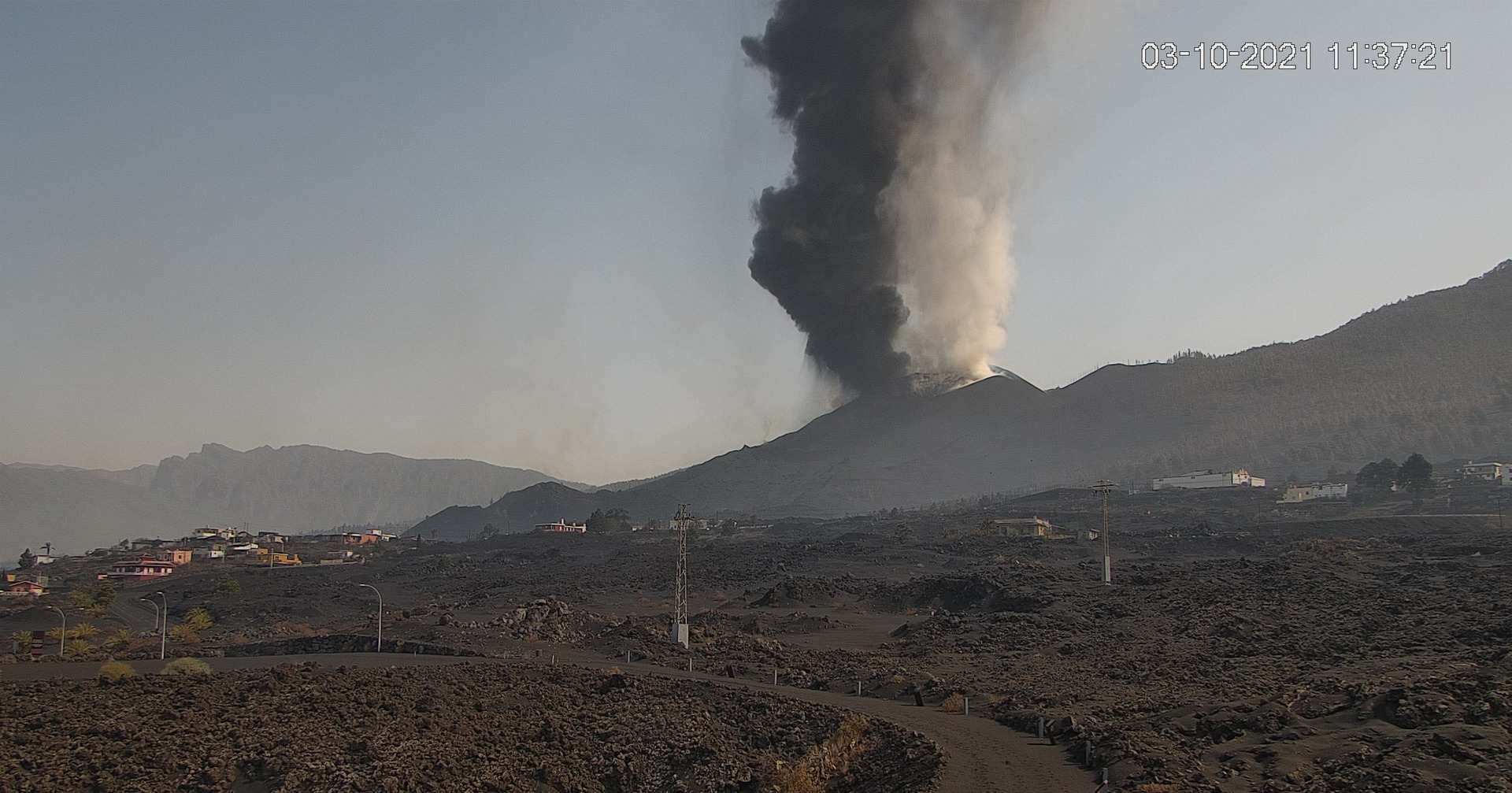
The Cumbre Vieja volcano on La Palma is a strombolian volcano. Such eruptions are small and stable, reaching 1-2 on the VEI scale (which runs from 0 to 8). The current eruption is VEI 2, with typical tall lava columns and occasionally some ash. It is rare for such volcanoes to produce so much ash that it causes significant problems farther away, but they can produce sulfur dioxide (SO2) and other important volcanic gases.
On La Palma I rented a car and spent the night in the island’s largest city, Santa Cruz de La Palma. The city is located on the east side of the island, sheltered from the eruption which is on the west side of the island. From where I was it was about a 30min drive to the eruption. A marked area around the volcano was closed down. The map can be seen under the Risk Assessment at the bottom of this report.

The first trip into the area was already fascinating. I drove the rental car along some narrow, local roads east of El Paso. The roads were covered with 2-3cm of ash, very interesting to drive on! I parked the car and made my way through the woods to a ridge from where there was a view of the eruption. The risk assessment at the bottom of the report describes which assessments I took before going there. The massive sound from the eruption, as well as two small earthquakes made the experience a powerful one. This was the first trip and in a bit of a hurry I had not immersed myself too much in the up-to-date information from the geologists in the area. I turned back a lot earlier than I could have done.
At this time, the volcano had built up an approximately 70m high volcanic cone. An ash-rich cloud rose from the cone, while on the northwest side of the cone lava erupted from a side valve. The lava that flooded out there looked almost Hawaiian, not strombolian.


To get a better overview of the area and the volcano, I took a trip to Pico Bejenado, a peak of 1852m just 8km north of the eruption. Up to this time, the volcano had ben active from two location. On this day, the main crater erupted a thick and dark cloud of ash rising 6100m into the atmosphere, before falling down again. But lava erupted from the west side of the crater, shown in the pictures above. This lava flowed straight into the cities below and was on its way to the sea.

While I went up, there was a change in the volcano. I felt two new earthquakes. Both were short, around 2-3 seconds and measured 2.9 and 3.1. I had never experienced an earthquake before, so I must say I thought it was very exciting every time. Not long after, the pattern of the eruption changed. As you can see in the pictures below, the main crater went from being in a stable ash eruption to exhibiting pure lava columns, in a more explosive form than those of the side vent. It was a typical strombolian eruption pattern. During this trip the lava reached the Atlantic Ocean and a toxic cloud settled like a lid over the entire area, which you see in one picture further down. This fog disappeared later in the evening when the wind dispersed it.


After the trip up Pico Bejendado it was late at night, but I still wanted to drive to the barricades to see the spectacle up close. I, like many others, stood by the barriers about 1900m from the eruption to look at the lava columns that stood 800m up. Seeing something like this from the streets of the city while it is being destroyed is something I probably will never forget. Something significant is still missing from this report and that is the sound of the volcano. The massive and roaring sound makes it almost impossible to talk to the others near you. It can be compared to a fighter plane taking off, only that it takes off constantly!


I slept for no more than 3 hours through the night, no time to sleep any more! I Went out again and observed the volcano from an area in the northwest, near the town of La Punta. The big challenge on that day was that the wind was very strong from the northeast. The falling ash blew around the island and made it uncomfortable everywhere. Around 70% of the island had been covered by various amounts of ash during the previous days. Inhaling ash was annoying but not much worse: the ash particles from this volcano are so large that they do not go down into the lungs (important with lots of nose hair!) But they irritate the eyes quite a lot. Glasses made it hurt worse when turbulence between the glasses propelled the ash particles into the eye. In advance, I bought a cleaner in relation to such particles.
It was thus set for a day with some distance from the areas closest to the eruption, at least for the first hours while the wind was strongest. From the vantage point above La Punta, I could see the lava flowing into the ocean and the chemical process that occurs when the lava meets water and turns into corrosive clouds. An hour after I sat down on the observation post, the volcano changed its eruption pattern again to a more ash-rich eruption from the main crater.


After a few quiet hours at the observation post in the sun, the trip took me to La Palma’s highest peak, Roque de los Muchachos with its 2426m. From here, of course, the eruption was clearly visible!

Then came the darkness and I wanted to take one last night trip and watch the eruption before my journey continued the next day. The wind still blew from the east / northeast, as strong as before with 15-20 m/s. But now it had been blowing for so long that most of the ashes that could be moved had been moved. With the constant wind direction and the stability of the eruption, it was vest to approach from the east, with the wind in the back while watching the eruption. I explored the terrain and for each ridge ahead there was a short stop to re-evaluate the framework and the risk. I was able to pinpoint an area just over 700m northeast of the volcano cone. The cone had changed a bit in character lately, it seemed to have started to sag in the west edge so that the lava columns also went further out, good of me who was on the east side since I had a good margin in relation to falling materials from the volcano. In the dark here I also met two German “volcanic tourists”. They were very secretive but wanted to get very close as they said. I never saw them again, so possible I was closer than them!


The strongest earthquake I felt was while parking the rental car in the parking basement at the airport. The earthquake measured only 3.1, but it felt more violent than the previous ones in that category. The quake lasted about 3 seconds, but all the cars vibrated, as did the pillars that held the airport up.

Risk assessment

Here I will make an attempt to convince you as a reader that I has made appropriate sensible assessments in relation to the three trips I made close to the outbreak. The map shows these three:
Trip no. 1. Distance from photo location to the eruption: 1900m
Trip no. 2. Distance from photo location to the eruption: 1500m
Trip no. 3. Distance from photo location to the eruption: 740m .
This is my first trip close to an ongoing volcanic eruption so the assessments were made accordingly. For many, it will probably seem headless to go as close as I have done, but I have written down the reviews I have made below. You get a somewhat misleading and frightening picture of the volcano in some media. I was more skeptical even when I went into the area before I saw the eruption, the terrain around, the weather and the wind and all the information from the official sources Involcan and Copernicus. Involcan had a very good information channel on Twitter with information and explanations. Copernicus added good maps and satellite images for good help. Wind and weather reports as well as satellite images and radar images, for which I like to use Windy where you can find webcams and the like. Live video was also posted on Youtube which could be checked when I myself did not see the eruption due to terrain obstacles while I was moving around. Yr also works quite well abroad and provides more accurate weather forecasts than any other service.

Trip 1: This trip was only a few hours after the lava reached the sea and high values of sulfur dioxide and hydrogen sulfide were measured in the area by the sea and up to the area I went into. I was actually going to drive back to the hotel after the trip up to Pico Bejenado , but quite suddenly the wind increased considerably from the east / northeast. It matched well with the wind message and satellite images of Windy and I could see that all the haze and fog that lay like a lid over the cities west of the eruption blew away. Driving down to El Paso, some low haze between the buildings was blown at full speed towards the sea. I drove through one scch fog and it smelled like a thousand rotten eggs. The air became clearer and I drove to the roadblock in the street in question. The roadblock is about 3km away from the eruption, but from there you can enter a new barrier that is manned closer to the eruption (1900m from the eruption). The biggest challenge with the trip was that the wind started to blow up so much that the volcanic ash started to drift with turbulence around the streets. Many other people showed up at the barricades to take pictures.

The distance to the eruption of close to 2km seemed good and that is probably why they have set the barriers here. All the ash and gas from the eruption itself and the lava flows blew in a safe direction at sea. The lava columns were up to 600-800m in height and threw the lava 200-300m out to the sides. A possible risk apart from lava, axis and gas is that the volcanic cone becomes unstable as it grows and slides down on the western edge as it is constructed on a steep slope. It can trigger landslides of hot pumice, ash and lava that can reach a few hundred meters beyond the terrain at the western edge of the eruption. The pressure from the volcano can blow the mass further out to the west, northwest and southwest depending on how the rift is constructed. The volcano was quite fierce when I was here, with lava columns that stood 600-800m up. GPS track from tour no. 1: Approach 3.
Trip 2: The trip went towards the eruption during the day. The wind direction went from west to east, so I approached from the north. There wasn’t much wind so I was tried to keep to the ridges where air quality was best. At this point I did not know exactly how much gas was coming out so I could not assess it well. Therefore I added some margin and kept my distance and stayed where there was some wind. The area had a good shower of ash from the day before, and there was warm ash on the ground, up to 15-20cm where I stopped (1500m from the eruption). I observed many different birds both high above the ridges and down in the depressions beyond (positive in relation to air quality). This mountain side has an inclination of about 10-15 degrees towards the sea in the west, so it takes a lot for high values of gases to remain in this area. I stopped and observed the eruption from 1500m. It was tempting to walk 300m to the next ridge which is the last high marked ridge before the eruption, but notification of a change in wind by the end of the day meant that I wanted to keep the margins while I still did not feel I had one hundred percent control over all risk factors. At this time, the ash cloud from the volcano rose 6100m into the atmosphere. Lava bombs and such materials were thrown up to 600-800m from the crater and up to 300m out of the crater. After the trip, I read the latest report on the gas measurements in the last few days, which gave me more leeway on trip 3.
A little more about gas: Usually SO2 (Sulfur Dioxide) is the biggest challenge in a volcanic eruption. The gas is colorless, but a small amount of it will smell strongly, with a kind of rotten egg so it is easy to detect. The gas, on the other hand, can mix with moisture and come down as acid rain (sulfuric acid), then it will be able to cause damage to the skin and eyes mainly as long as it is not inhaled in a way. InVolcan measured 7,000-11,000 tons of SO2 per day in the days before the lava reached the ocean, a modest value. By comparison, Pinatubo emitted 20 million tons of SO2 over a few days in 1991. A volcano in Iceland emitted 120 million tons of SO2 that killed tens of thousands in northern Europe in the 18th century. Kīlauea in Hawaii also erupted the day after I went on this trip: it spewed out 80,000 tons of SO2 per day for the first two days which can present health challenges if you have asthma or other respiratory challenges.
CO2 (Carbon dioxide) can also come in large quantities from volcanoes, it is both colorless and odorless and difficult to detect without measuring instruments. Fortunately, CO2 is easily transported away by wind and pressure from the volcano so it usually goes straight to the higher layers of the atmosphere. H2S (Hydrogen Sulfide) also occurs and is perhaps one of the more dangerous gases from a volcano as I have understood it. It is formed when sulfur from the magma reacts with water and is often a challenge in volcanoes that are close to lakes, have a large lake in the crater or are connected to large amounts of groundwater. Water is something La Palma is in short supply, both groundwater and lakes are absent from the island. InVolcan did not mention any hydrogen sulphide in its report on the measurements made. Otherwise, different gases are formed when the lava burns through various organic plants, houses, buildings and materials. The gases are easily carried by wind. GPS-Track from trip no. 2: Approach 2.

Trip 3: The wind that had started the day before had blown strongly throughout the day. Strong wind, 15-20m / s from northeast to southwest was blowing ash and gas to the sea. The biggest challenge was all the ash that blew around. The residents down in El Paso had to walk around with goggles. In the media, there was a lot of attention about the dangerous gases that occur and it probably scared those who read it. From InVolcan, which publishes the official information, very few dangerous gases are measured and those living on La Palma are reassured. There was talk of the formation of larger amounts of hydrogen sulphide down by the coast where the lava flowed into the sea and this formed some fog that was corrosive, but not a danger to those who lived on land even though at one point they were encouraged to stay inside one village near the harbor. Involcan had a boat standing close by at all times and never measured high values of H2S while I was on the island. In any case, this was not a real threat at the altitude I was at (600-1300 masl). There has also been increasing earthquake activity throughout the day and some hobby geologists and fans presented the idea that a new and larger crack could soon open some kilometers south of the eruption. The media bought this and some drama unfolded online. This was written off as a probability from an official standpoint with good and logical counter-arguments a few hours later.
When starting the trip I had no goal of where I could get to. I was looking for a safe area with a good overview, preferably with a canopy north or east of the eruption. There are fairly steep mountain sides above the eruption, so if you want to stay safest closest to the eruption, it is from this angle with good wind direction. The eruption was a bit weaker than the day before with lava columns 300-400m high with some fountains and lava rocks up to 500m. Coming closer, I saw that the lava columns angled slightly to the west rather than straight up as yesterday, an advantage as no lava bombs or materials are fired more than around 50-100m east. I thought this might show a weakness in the volcanic cone, sagging on the west side is logical on a fairly steep slope going downhill to the west. This was confirmed two days later when it was expected that there would be a landslide to the west which could change the volcano’s behavior to some extent.
I got into an area just east of the volcano, with some canopy and with a lot of wind in the back, so much so that I had to search a little around to find shelter. Here I was also not completely alone and some geologists were taking pictures (they had driven up with an ATV). There were also traces from 5-10 others who most likely had been here through the day after the wind turned. From here I had a good overview, some 700m from the eruption, and at least 600m clearance of any falling material. Here the ash was the deepest of what I had walked on, between 30 and 50cm. I dug down a couple of places and found that it was quite warm (50-70c) even two days after it had fallen here. GPS-Track from trip no. 3: Approach 4.
So now I have become a volcanic tourist. Fortunately, that is a healthier tourist than the charter tourist!
Christian Nesset


Btw: If you scroll all the way down, at the https://eruption.acme.to/la_palma.php you can see two spectrograms.
Now I claim that I roughly know how to interpret a spectrogram. For instance, especially from the right one, I can infer that most of the tremor’s energy is concentrated at about 1 Hz.
I can also see thin strong lines in the diagram, that show the energy be distributed almost evenly from low to high frequencies. Those must be the earthquakes.
But I can see the tremor in the dedicated tremor plots too, same as the occasional earthquake signals.
I’m just missing the spectral distribution there.
So why add a spectrogram? What information about an ongoing eruption could I infer from a spectrogram that I can’t from just looking at the tremor diagrams?
From the spectrograms for Geldingadalir Iceland, the 4 hz range would come up higher when the volcano went into eruption. You can use the spectrogram to help determine when magma is actively moving under ground.
Lava flow over industrial area of Callejón de la Gata
https://twitter.com/RTVCes/status/1446868002150944770
https://twitter.com/RTVCes/status/1446871503199510536
A breathtaking photo on the front page of “El Time” showing the flow moving northwards:
https://www.eltime.es/
Just incredible…
One of the avalanches :
At the moment there are always phases during lots of lava are gushing out like a waterspout fountain. The inner walls of the crater around this effusive vent collapse repeatedly, which can be seen from the brownish ash clouds. The flow has swollen again. This is bad news for the industrial area at “Camino de la Gata”.
For all who want to help the affected people on La Palma (meanwhile about 1000 families have lost their house) here is the official donation account:
IBAN: ES47 2100 9169 0122 0017 9456
BIC: CAIXESBBXXX
Recepiant:
Cabildo Insular de La Palma
Purpose:
Donación volcán
“But the lava has already destroyed or damaged over 1,150 properties, and forced 6,000 people from their homes.”
https://english.elpais.com/spain/2021-10-07/spains-la-palma-struck-by-new-quake-and-more-destruction-from-erupting-volcano.html?rel=mas
Decent report of situation on Oct 7th
https://www.youtube.com/watch?v=tuFD8azQT24 other people saw the lightning over the cone complex last night. This type of lightning makes a unique sound, a little bit like a shotgun discharge. One flash that I saw was a beautiful green color.
I also saw lightning when reviewing what happened last night.
I think I saw exactly the same lightning strikes as in the video.
Lightning is amazing, but volcanic lightning is absolutely incredible!
If you watch the Martin Rietze video of Volcano Gunung Ibu night time eruptions, https://www.youtube.com/watch?v=qMkfT1e4HQQ you can see and hear the lightning strikes at the following markers in the video:
min:sec
5:20
5:43
5:54 good
7:36
7:44
8:13
9:14
9:17
9:24 good
yet another spectacular collapse on the lower vent. local time 19:13
https://m.youtube.com/watch?v=t19jPW4q_2g
An Impressive video showing a giant Canary Date Palm being incenirated by very fast moving Aa lava rivers. The radiant heat is so strong it simply auto ignite, crown going up like a matchstick box
I guess that in air temperatures close to 1000 C most stuff even if its high water load .. will auto ignite, even green plants:
Waste to energy plants here in Finland and Sweden burn quite wet household waste .. that burns on its own, due to the heat stored in the boiler refactory brickwork, they never needs to use the boiler oil burners Once its started.
Still Impressive to see a living Palm go up in flames like fireworks, radiant heat from the lava was sourely extremely Intense
Still Impressive To see that Palm Auto combust .. fast moving Aa flow rivers gives off alot of thermal radiation
Palmas tremor graph looks pretty hairy today.
Many earthquakes in the usual area and depth 10 -15 km and around 30 km.
Numbers of quakes are piling up compared to the past days.
Credits graphs IGN
It appears to me as if there was more gas coming from the explosive vents than lava. Also it is getting very quiet in between.
Furthermore it is very unsteady, with noticeable silence between the phases.
Is the volcano close to being empty possibly?
Jesper S. mentioned that geologists were talking about an intrusion of 10e6 m^3, of which 100e6 have already erupted.
So should really be to a close now?
Also, a rough extrapolation using the prior eruption lengths suggests a length of about 18 days, of which 20 have elapsed to date.
Tremor is also a bit less than other days…
Sorry, the “already erupted” figure is from the afarTV feed.
Probaly will be more .. But it have alreay erupted over 100 million cubic meters .. Supprised it have not gotten more fluid yet
Perhaps. The relation high quake activity and ending eruption seems odd to me.
And the tremor signal is broader than I ve seen past days. I admit I didn’t watch every day…
The extrapolation… eh, don’t think we should look into that seriously. Every eruption is unique.
If we had more data of those historic eruptions, comparing would make sense. We don’t have them unfortunately.
M2 and M3 exceeds 100 / day for the first time. Even 120 and still counting.
Someone knows of new figures concerning how much lava is outflowing at the moment?
Got the impression it fluctuates, today quite high though.
Yes, it seems to fluctuate substantially.
Are we in for FAF pulsating mode then? At the moment the cycles appear to be very fast, compared to FAF though…
If there are, there’s to much noise to recognize them in the tremor graphs.
3.9 mbLg SW VILLA DE MAZO.ILP
2021/10/09 20:05:35
38
https://twitter.com/NaqNab/status/1446932157318893569
The new rupture of the north flank is causing a lot of damage in the industrial zone and is advancing at great speed. It has melted a communication system causing difficulties for you to update data here
https://twitter.com/involcan/status/1446904315298385920
The north flank of the volcano has just collapsed
https://twitter.com/NaqNab/status/1446921983359340546
Looks like a small error in the location of the satellite. This gives a phase error
Or a detachment fault at work? Hope not – But those tremors are not reassuring.
Knowing Canarian mentality a bit (maniana) I wonder if they should straighten up and ask people orderly and without hysterics to keep impaired people from the beaches, watch the behaviour of the water and animals (hear tsunamis rolling in on time) closely and not fall asleep on the beach as long as these quakes go on. On the East coast of La Palma, on Tenerife and on Gran Canaria. And El Hierro.
100 000 years is a statistical dimension.
This would be little. No reason to be afraid with awareness. The people on the Andaman and Nicobar islands, closer to nature, followed their animals up in the hills.
Or too much?
Awareness is generally too low, comfortable sleepwalkers of Western society.
It’s always a choice between staying put and evacuation. There are compromises.
https://www.youtube.com/watch?v=INvrtMg5tSQ another flow down the channel around 9:31 pm CET
https://twitter.com/NaqNab/status/1446937915859161089
Where do they hide the time stamp on the La Palma live stream?
https://twitter.com/NaqNab/status/1446934839609810946
Stratigraphy of falling pyroclasts in #LaPalma
Base corresponds to the explosive phase and lasted from 19 to 26/09
Intermediate level, phase of least explosiveness between 09/27 and 10/3
Top tier, most explosive stage deposits from 3/10 until now.
It’s certainly blasting away tonight.
Having built the cone it now seems to be dismantling it.
New flooding on la palma
I have the eye lock on that blocks…..

They ran way
There was a partial collapse on the left side of the cone at around 23:08:22 on the afarTV cam. It was short lived but amazing to see.
I should add that it’s amazing to watch as a spectacle. At the same time, i feel for those that have lost homes and lively hoods to this eruption.
(23:38 +- 2) min, https://youtu.be/INvrtMg5tSQ: Off there goes another one.
New block moving to the exit
More earthquakes
3.7 mbLg NE FUENCALIENTE DE LA PALMA.IL 2021/10/10 00:01:25 13 +info
3.1 mbLg N FUENCALIENTE DE LA PALMA.ILP 2021/10/09 23:32:33 11 +info
La Palma. Is the ‘blow-torch’ vent on the current cameras the only vent? Or do the other vents continue behind and above this one?
Updated 4pm, 9/10: IGN Canarias director Maria José Blanco has contemplated the collapse of the platform created by the main lava flow, the platform called variously isla baja or fajana. This is because the accumulated lava has now reached the height of the cliff itself but is still constantly being pushed from behind by additional lava. The platform currently rests on a shelf that is narrow because La Palma is still a young island in relative terms and beyond this shelf, which is still geologically unconsolidated and so rather unstable, is a long deep slope to the seabed. A wave will form in this scenario, and naturally Blanco’s words have been interpreted as an announcement of an imminent tsunami even though she said nothing of the sort. And so today, Pevolca technical director Miguel Ángel Morcuende has explained that should the fajana collapse, as is quite possible at any moment, he said, it would nonetheless only have an impact in the area already evacuated.
Morcuende explained that existing evacuations had been carried out on the basis of anticipated risks, which included the danger of the fajana collapsing. The wave, Morcuende said, would be 5m high at the point of rupture with an extension of up to 150m, and so its intensity, which is inversely proportional to the distance. would decrease very rapidly. More noticeable and significant, he considered, might be the accompanying explosions as water vapour and gases were released. His overall message, however, was that this was already in their minds as a possibility which had been planned for, and which would not present a problem such as is envisaged by the dismissed megatsunami theory where half the southern part of the island breaks off, and that the two scenarios were wholly different … only one being realistic.
Anyone know of a map of the evacuation areas?
Cumbre Vieja (several models) and historical tsunamis:
https://en.wikipedia.org/wiki/Cumbre_Vieja_tsunami_hazard
From article:
“even for a 80 cubic kilometres (19 cu mi) slide would reach heights of 100 metres (330 ft) in the city of Santa Cruz de la Palma, (population 18,000) while the largest city of La Palma, Los Llanos de Aridane, , population 20,000) may be spared. The waves would take approximately one hour to propagate through the archipelago, and important cities in the entire Canary Islands would be hit by substantial tsunamis irrespective of the landslide size.
So, this is a scenario für a smaller volume.
why would 80 km^3 go in one go?
It has happened, but only by collapse of the side of the main volcano. The last time for a large collapse in the Canary islands was at El Hierro. La Palma has had several over its existence. Cumbre Vieja is a different beast. It is a ridge, and any collapses would affect a small part of a flank. The bench and cliff build by the current outflow could collapse, with a volume much less than 1 km3. But Anak Krakatau has shown the inherent dangers of even such a collapse. A westward landslide would impact La Palma itself, but would have less effect on the other islands to the east.
https://twitter.com/VolcansCanarias/status/1447020580281139202
On 10/01/21, highly noisy, energetic and sustained explosions began. Vibration of soil, vehicles and crystals in the entire range of more than 5-6km (approximately) from the eruptive center. Phenomenon not observed until now. Persist at 02.55h
https://twitter.com/VolcansCanarias/status/1446998196593561602
https://twitter.com/VolcansCanarias/status/1447116458090274818
https://twitter.com/NaqNab/status/1447093410381418499
Moments from Tonight:
Timelapse of 3 landslides / collapses of one of the cones.
Timelapse de 3 deslizamientos/derrumbes de uno de los conos.
https://pbs.twimg.com/media/FBUimdAXMAYs85D?format=jpg&name=large
What is the excavation equipment doing bottom right?
Abandoned?
I think so…
Probably Manolos gravel plant (Kieswerk) mentionded yesterday in Martin’s column http://www.casamartin.de/kolumne/kolumne_la_palma_aktuell.shtml.
[08;21h UTC+1] Lava flew over the carretera puerto Naos south of clínica veterinaria Terravita. This is far north of centre Todique and will destroy again new property. The horror continues on #LaPalma
3.0 mbLg
S EL PASO.ILP
2021/10/10 07:37:03
39
+info
3.3 mbLg N FUENCALIENTE DE LA PALMA.ILP
2021/10/10 07:35:55
11
+info
3.4 mbLg SE EL PASO.ILP
2021/10/10 07:32:23
39
+info
2.9 mbLg
SW VILLA DE MAZO.ILP
2021/10/10 07:22:22
35
Deep quakes continue…
The description of the 1995 Fogo-eruption on Wikipedia with i.e. a “curtain-of-fire” lava fountain sounds very similar to me, but I would wonder what specialists say about that, Chad i.e. Please.
Or Luis Godinho, of course.
I’m not a specialist of anything… there are here people who are the true specialists.
I just post info that i think that can be interesting or important.
But agood watcher I’d say.
Albert might write s.th. about this.
I thought that the landslide scenario was out of the question, but seeing that there are lots of models and only the 2001 model estimated as improbable shows me that lots of scientists are working on it which means that nothing is impossible.
The consequences for NYC might be minimal, but for the Canaries, Senegal, Ivory Coast, Morocco and the West of Portugal, also Madeira, not so pretty. All of them equipped with nice beaches and sun.
Yes, fot Portugal and our islands could be terrible… just hope not!
Fogo erupted in 2014 too, both its recent eruptions were a lot like Tajogaite but both were a lot less intense too. Tajogaite is not a big eruption by any means but it is by far the biggest eruption to happen in the Canary islands since the 1730s, and probably second only behind that actually, (still at this point a very distant second though).
I read that all people around Fogo fled on time, and there was no serious casualty. They didn’t wait for Nanny State to tell them what to do. Their town is completely buried after the two eruptions in 1995 and 2014.
Difference is population density though, La Palma is much more populated and the eruption is a lot more powerful, theres videos of the lava flow on Fogo where people literally climb the channel and look down into a river of lava, doing that on Tajogaite would be next to suicidal.
Would say actually all things considered the situation on La Palma has been managed fantastically.
Nothing must happen. But the Cascadia-models have created more awareness. People must know how to behave and where to go. They need knowledge about flight paths. States cannot deal with this alone, although they simulate competence. People themselves should know what to do.
I had friends in Phuket when it happened in 2004. They were lucky as they had only arrived the night before and slept longer. Otherwise they might be dead, five adults, two children. They woke up when the water started rising under their beds in their bungalows. That was after the wave.
The main thing for their parents and friends was that there was no telephone connection, so everybody was extremely worried seeing the pics. They finally called after eight hours from a city inside Thailand.
I’m struggling to understand the point you’re trying to make.
The “nanny state” is incompetent, people themselves should know what to do.
And how are they supposed to come by that knowledge without state funded scientists and institutions?
Twitter, youtube, facebook?
I stand to be corrected, but I believe that Denaliwatch is merely highlighting the importance of each person taking a level of responsibility for their own actions and responses, rather than waiting to be told what to do.
In that case I stand corrected. I thought I heard a psalm from the well-worn “don’t trust the experts, ordinary folks know best” gospel.
You are right. I also want to emphasize that this is not going against scientists at all, but against politics. Politics is missing out on education, also about things like these, and people who want to think themselves are starting to educate themselves, but that is not everybody.
What is the meaning of the deep (30 km+) M3+ quakes?
What is the meaning of the “normal” (about 10 km) quakes?
I’m asking in terms of the current eruption.
I have been seeing a lot of comments the lava is not super fluid yet. I would disagree, 1949 was only slightly above the rate of a tube fed flow, so for it to have pahoehoe is not unexpected. Now we are looking at rates of at least 60 m3/s, to as high as 200 m3/s, and the lava is directly erupting from a fountaining vent, all of these will encourage the tansition to a’a. most likely there is also a high load of solid lava fragments from the more explosive vents, and from the cone eroding around the flow, so it is not all liquid lava. This is not seen in Hawaii or Iceland because lava flows there are rarely associated with powerful explosive vents in close proximity, but it might be very common on Etna and just not recognised until now.
Looking at how these enormous boulders are being rafted through the discharge channels, I tend to agree. Many people are calling these events cone collapses, but I see them more as periodic throat-clearing.
https://www.youtube.com/watch?v=zi9pKviZRwE
Look at 2:30 on this video, not sure how big it actually is but I am willing to bet that lava is flowing at many tens of km/hr. By my best guess the slide is about 200 meters long and the lava flood released moved over it in about 8 seconds, so probably close to 90 km/hr. The slope is very steep, so for the lava to flow this fast is maybe not so surpising really. I would actually expect a fluid lava to flow even faster than water on the same slope angle because of its density, maybe at least above a certain point that the viscosity is not important compared to gravity. Nyiragongo has flows this fast on its upper slopes, and Kilauea too inside steep craters (and maybe on the south flank?) so its possible.
Did you see this boulder ?
https://www.facebook.com/groups/vulkane.net/permalink/4466904263347712/
Also on Youtube
Now that is impressive Doug! Never seen such huge boulders on a lava flow-big as icebergs except their lavabergs..
Thought Etna could do flood basalt … but could be wrong.
It can, but not often. 1669 was the last time. But given the amount of activity at the summit in the last 50 years and current historical all time high stand of the magma conduit we could see another one soon.
Iwould guess though a lava lake will have to form. Etna isn’t known for this really in recent time but if the conduits get too wide fountains will no longer be possible there. Eruptions before 1669 were often completely effusive even far from the summit, and in general the are less actual mentioned eruptions, meaning less paroxysms and explosions, so likely there was a lava lake back then too which drained out.
A new ocean fall coming soon. Live:
I’m no expert, but this flow I think is going west between Mount La Laguna and Mount Todoque. They seem to have moved the viewing point from Puerto de Tazacorte to Mount La Laguna either to get a better view or to be higher up to avoid the wave if there’s a land slip.
Possibly as little as one kilometer to the sea.
Is this north of the Montana La Laguna? No platform in front of the coastal cliffs, and offshore rocks in the foreground…
Oops, wrong crater, I meant Todoque. Too zoomed in on giggle maps…
That can be the last lava finger with cross the industrial park and now has reach the coast?
Other deep earthquake on mazo
4.1 mbLg SW VILLA DE MAZO.ILP 2021/10/10 11:54:46 37 +info
Not sure if the same finger, the industrial park is far up the hill and the movement is slow. I guess other lava came next to the lava field and reopened the north path or opened a new one.
we will see.
The new lava flow, yo yo 1240°C has destroyed the few remaining buildings at Todoque north
https://twitter.com/involcan/status/1447138047154429955
That flow is NOT 1240 C 😉
Where did they measure that?
Have they measured close to the vent?
If it was that it woud flow like a metal river like Fagradalshraun did close to the vent.
Aa lava flows are often around 1100 C and somewhat below that even.
This is data from INVOLCAN… so it is correct.
Anyway this is the maximun measure they got. When the say “hasta 1240” .
No idea where. Could be a mistake. But it is official tweet and media is saying the same.
Not necessarily. Temperature is essential, but the magma composition is also paramount in fluidity, and it is probably quite different from Hawaii.
The Canaries underground is weird, one study even concluded that this La Palma lava comes from rejuvenated magma rather than straight from the hotspot…. In any case, every hotspot has a different magma composition despite the lack of evolution in some chamber. And I read somewhere that the Pacific and Atlantic hotspots are quite different.
Would tend to agree with Jesper, the lava isnt really glowing bright enough to be that hot, though it flows very fast in places so is at least a reasonable temperature, probably at least 1150 C. Maybe the mineral chemistry reflects that temperature not long before erupting, but if it was actually 1240 C on the surface it would glow bright orange to yellow even in daylight, which is not the case.
If it is a higher temperature though that would mean magma from a greater depth, so maybe more basantite than tephrite, where the olivine hasnt had time to settle out. If it is still tephrite I dont think this is going to end any time soon, not for many weeks at least, maybe much longer.
My reaction was the same as Jesper’s when I stumbled upon that figure.
Now watching the video, I wonder seriously whether they accidentally put °C instead K.
Black-body theory gives that flow a mere 1000 °C.
Watch from 2:13 and you will keep noticing some random bright popups, which smoke afterwards.
Just what exactly is that? At first I thought it was briefly exposing the well insulated lava core itself, now that is at least what I would expect 1200 °C to look like.
Now after closely watching for a second time I’d prefer go with orphaned gas pockets from superheated soil from the ground beneath, instead of true how lava spots…
#URGENTE #AHORA
Now
Lava moves at 700m/h at the industrial park zone at 13,30 Canarian time
https://twitter.com/NaqNab/status/1447186577160122371
Lava running north of Mt. Todoque in steep terrain.
See also the above post by javi (12:00).
This is from a very nice page, where you can also compare the current with the old state:
https://riesgovolcanico-lapalma.hub.arcgis.com/apps/e81adc67019244f599dd5abe6c3ec9bd/explore
Updated map, few hours ago:
https://pbs.twimg.com/media/FBWLsZwWQAEdopi?format=jpg&name=4096×4096
3.7 mbLg SW VILLA DE MAZO.ILP
2021/10/10 13:13:49
14
+info
3.2 mbLg SW VILLA DE MAZO.ILP
2021/10/10 13:09:14
34
+info
4.0 mbLg N FUENCALIENTE DE LA PALMA.ILP
2021/10/10 13:05:40III
38
https://twitter.com/NaqNab/status/1447187890325311496
There goes another water reservoir. The lava in this image is advancing north of the Montaña de Todoque. Lava will thus one day flow into the sea again, from the north side of this 2k year old cinder cone.
Maybe it is a good idea to arrange these informations in subthreads (by hitting ‘Reply’ to posts with the respective topic)? That way we wouldn’t have all these Twitter links just posted after each other and keep some order in the cafe. Just a suggestion.
This really reinforces just how steeply terraced this landscape is; looking at the terrain layer on giggle maps is very deceiving.
More deep earthquakes
– 3.7 mbLg SW VILLA DE MAZO.ILP 2021/10/10 13:13:49 14 +info
– 3.2 mbLg SW VILLA DE MAZO.ILP 2021/10/10 13:09:14 34 +info
– 4.0 mbLg N FUENCALIENTE DE LA PALMA.ILP 2021/10/10 13:05:40 III 38 +info
drone view on lavabergs floating. sorry if this was linked above..
https://twitter.com/Quicktake/status/1447236013705859074?s=20
I think this might be turning into a big financial loss esp. if it goes on as most people here assume. It is the area with most agriculture and also the area with most tourism as it has (had?) sandy beaches (black sand) and western sun with sunsets. Santa Cruz has morning sun and a nice view of El Teide.
I myself staid with people in the North near Garafia and Las Tricias, and when we went for the beach it took a while. I also staid in La Palma Romantica once, a pretty hotel in Barlovento in The North-West which is fine for hiking on Taburiente. No beaches, but indoor pool. Quite windy and colder than the middle. Then I was in San Andres y Sauces, pretty, swims mainly in the charcos in the middle of volcanic landscape. Nice, though and Santa Cruz nearby. Fuencaliente in the South is also black rock.
So in the middle they have their main vacation spots and tourism, Los Llanos being quite pleasant. It is relatively short ways to every other place on the island (nothing is really short there, lots of barrancos).
So this is a very unpleasant situation for them. I feel pity for them. They did so much to attract some tourism. And now they have this after two winters with Covid-regulations.
There is one good thing though: The timing. It is not exactly a place to go from November to mid-February. It is coldish, windy and wet, also foggy, contrary to Gran Canaria, Lanzarote and Fuerteventura. Tenerife can be cold too, but not as cold as La Palma. Maybe it is finished by March.
It should be finished well before March, based on past behaviour. The damage is immense. Perhaps they can attract volcano tourists, as Heimaey still does. The cooling lava can provide an energy source perhaps for decades. And the lava flows are perhaps not as wide as appears: much of the land remains not affected. But the material damage could reach close to a billion dollars, and the economic damage even more.
As a percentage of the entire island its minuscule.
It will be a tourist attraction for decades, perhaps a century.
One hopes everyone was insured, although that’s not much help if your business is trashed.
I am afraid life is unfair, and always has been.
It is not miniscule compared to the usable (and best) land of the island. Most banana plantations i saw were in this general area, in my recollection. It won’t be a large fraction, but could easily be some per cent of the best land.
Albert is right, the agriculture is centered in the middle ob both sides as tourism is as well. So, it is a rather big chunk.
The North is practically Taburiente with steep walls and barrancos.
https://twitter.com/VolcansCanarias/status/1447273508527030274
Eruption 19.50 Eruptive column lightning strikes.
#ErupcionLaPalma | The fajana occupies 34 hectares
It reaches the limit of the insular platform, so a landslide could occur that would cause waves, according to #Pevolca
https://twitter.com/RTVCes/status/1447273558305017857
Black and white
More stillcams here => https://eruption.acme.to/la_palma.php
North lava arm near to reach the clifts and the sea.
Sentinel over La Palma:
