
Welcome to the Volcano Café bar, a place for all things on or off topic and inane ramblings. There has been a need of late to find a place better suited to various theories, long comments and enthusiasm. This page will be less moderated than the main article pages and cleared out every month (this may change depending on use).
Have fun and don’t forget to tip the barman 😉
Got a question here… after looking at the Pico mountain in the Azores in papers, I am very confused – how could such a stratovolcano like that form (dumb question, I know), and I mean what this paper describes:
https://www.researchgate.net/publication/236213423_VOLCANIC_HISTORY_OF_PICO_AND_FAIAL_ISLANDS_AZORES_AN_OVERVIEW
Basically a combination of mostly hawaiian and a few strombolian eruptions (mostly effusive) they say, whereas a typical stratovolcano has a more extensive range. I tried to look everywhere for the processes that would form it, but nothing nonetheless. I have a few hypotheses for this:
1. Lava lake slight over-spill, where the cone contained a lava lake that doesn’t spill very far, building steeper and steeper slopes.
2. Cone burial, of which some sort of spatter cone existed and got buried by another cone, and repeat the process until you get a true mountain.
3. Explosive component, of which a cinder cone forms and gets buried by a newer, more effusive cone ’till the next explosive eruption.
4. Shield short-flow, similar to lava lake overflow but with more vigor.
5. Combination of a few?
With that, I have no idea. It makes me think of some giant hornito (ironic, since it has one on the peak).
Like Pu’u O’o in the mid 80s, a high fountaining vent. Though more gas rich, so probably more like Etna. Nyiragongo was probably the same, up to maybe not that long ago really.
Shishaldin and Villarrica are probably the best present comparisons. They are in an arc setting but despite being stratovolcanoes erupt lava that is very fluid, Villarrica has pahoehoe around it and a lava lake. Vesuvius before 1944 might be another comparison, mafic but quite explosive at times.
I guess maybe a large volume of deep magma managed to find a clear way to the surface and erupted slowly for a long time.
While we wait for something exciting, I did a few pieces of artwork I have been working on this week:


This one is based on the current project I am working on.
This one I did, just because… (called Mountain of Fire).
I’ve just published an article as a preprint on the Eartharxiv platform. It’s my most ambitious work, one I’ve spent months on doing graphs and writing, and longer than that on investigating. It’s aimed to redefine paradigms in Earth’s sciences. But it’s a lot, and it’s very controversial, yet to be considered by the academic community, so I will only post in Volcanocafé if the readers are interested in looking into some of the ideas:
https://eartharxiv.org/repository/view/7656/
Hi Hector – following up on your comment on the tsunami thread:
That is especially interesting since the 2024 hurricane season is underperforming quite significantly. It was initially projected to be more active than average but so far has been very quiet.
That would fit with your hypothesis, since if nucleation of rainclouds is reduced at the height of the solar cycle, which we now are at, that might reduce the convection-driven generation of hurricanes.
CERN did a quite detailed experimental study of cloud nucleation, which I mentioned:
https://home.cern/science/experiments/cloud
They found a lot of interesting things, like the interaction of SO2/H2SO4 with ionizing radiation to seed high altitude clouds, and likewise the effect of things like terpenes that trees emit – which also seed cloud formation.
My hypothesis has nothing to do with nucleation, though. My understanding is that major hurricanes peak in the second half of SCs, see (note the secondary y-axis is inverted, more is down, “grandes huracanes” means major hurricanes, 3-year averaged, and “manchas solares” solar sunspots, it’s from a Spanish internet post):
It could fit the solar wind dynamic pressure peak in the near-Earth environment which encompasses the second half of SCs, probably because sunspots move towards equatorial regions of the Sun and point more directly towards Earth towards the end of cycles. At least that’s my personal opinion.
The current SC25 has yet to pass the mid-point, assuming average length, should do so in some months.
Sure. I’m just pointing to a possible mechanism for the data you have published. It’s good data! The CERN study is nice since it is from a completely independent dataset, so if the one is truly correlated to the other you would have a nice explanation for your data!
Thanks, it certainly is a possible mechanism for the size of hail. I don’t think it works for volcanism though; you have to turn to other mechanisms, like electromagnetic induction as proposed in the article, which can easily penetrate hundreds of km into rock material and target thick layers of conductive material like the asthenosphere.
Icelands current latitude 63 – 66 N and yes I wants to live there due to being basicaly free citizen and having that unqiue volcanic geology even if the weather is cool and wet for most of the year in Reykjavik. Woud Iceland look diffirent in glaciers size and landscapes if it was 53 – 56 N in latitude? woud Vatnajökull be any smaller not soure if the sun woud be any stronger ? Im soure it woud have been glaciated during LGM even at that locale
You need cold and snow to form a glacier. So the first question to ask is whether there would be more precipitation. At the moment, South Iceland gets much more than North Iceland which is why all the glaciers are in the south. The LGM was cold and very dry, and it is not automatic that glaciers would form. Altitude is important, of course. A thick glacier makes its own altitude and that helps stabilize it: it is much colder because it is much higher than the ground. It seems unlikely that Vatnajokul could form glaciers much further south if they didn’t already exist. But if you were top m ove Iceland with its glaciers, some might survive – at least for a while. With current global warming, most of Iceland’s glaciers will be gone in 200 years even in their current location. Moving south would not help.
I meant what Iceland woud look like today.. at that latitude 53 – 56, that latitude in atlantic is very humid and rainy indeed perhaps Vatnajökull woud not exist in that locale more than being a few small icey spots in Bardarbunga and Orfa if Iceland was there today. Grimsvotn caldera lake woud be a huge cold Ireland highlands looking thing with dark waters, rest of Iceland woud likey be rather very green and agicultural expansed woud be more widespread, it woud overall be even milder and more habitable than it is today. Reykjavik woud be a mild and green place in that situation with likey temperate broadleaf forests being natural tree covering in an interglacial even if it still woud not be very warm, still summers woud get up to t shirt temperatures much more often in that version of Reykjavik, Ireland woud likey be analougus in climate conditions and Iceland woud be just as overgrazed. Vik and Reykjavik woud get warm enough to support some subtropical plants at latitude 53 in the mild breezes of the Gulf Stream like Ireland do, the highlands woud become prime sheep grazing lands, Svartsengi eruption flows over farmlands in this scenario
🙂 And If you move Iceland to latitude 83 – 86 N I guess it woud have never even be settled for more than a few Inuitan villagers from greenland, Vatnajökull woud likey cover everything down to Katlas glacier coasts and strectch towards Langjökull as a single solid Icesheet.. ( Laki woud be a mega sized gjalp with an effusive tuya stage ) the icecap may reach way beyond Krafla perhaps towards Husavik at that location, another huge Icecap near westfjords merging with langjökull icecap. Katla woud get the name ”uunnaavik” Iceland itself woud likey have the name ” Nunamik ”competely icecapped with perhaps only the fringe of sourthen coast and coastal reykjanes penninsula being unglaciated, many of todays volcanoes woud be un – named buried under ice, Holuhraun woud be a gjalp like event just bigger with perhaps a short lived effusive tuya stage. Much of Northen Iceland woud be totaly unpopulated
Latitude 73 – 76 is intresting colder than todays Iceland but perhaps not very much so, woud likley not be that much diffrence than current more than that Vatnajökull woud be much bigger and souch and that natural vegitation woud be a marine type tundra rather than todays birch forests, Hekla woud have a small icecap covering most of it in that scenario, likey almost as settled today just with a colder climate overall, perhaps cool enough to form some small ice domes over hengill, Snaefellsjökull woud be icecapped down to a few 100 s of meters to sealevel, another ice dome covers Westfjords in this scenario almost to sealevel, Torfa also haves a small icesheet in its caldera. Reykjavik and Vik woud get good snow every winter and get a rather forgettable summer that woud be 10 c as high summer unlike todays 18 c as a warm summer day. Husavik and Akureyri gets some brutaly cold winters in this scenario
Its possible that Vikings from Scandinavia woud get to Iceland first in all these climate scenarios the Nordic seafarers where looking west to colonize new lands areas
Greenland’s viking colonies were quite a bit further south than Iceland, so that gives an idea what is possible. Jan Mayen is further north and is as tall as Iceland, so that is the opposite idea. Perhaps no real need to speculate when actual examples are available!
Westfjords at 86N woud be named Kippasissut – kangerlui : )
Does anybody know where the hell I can find some good InSAR data for Iwo-Jima?
So…there was an event where the scientists from the IGEPN discussed potential crustal failure at CCN and some other scientists from Japan did an analysis on Iwo-Jima magma system. If anybody has access these findings, it would put a big smile on my face.
https://congress.iavceivolcano.org/content/uploads/2024/02/full_conference_program_v6_feb_revised.pdf
As I said in April, If we get WW3 or Avian Flu pandemic before my VEI 7 eruption, I will be pissed
As Trump promised, the presidential elections in November could become the last ones …
I saw a recent answer in a science magazine to a question that I’ve thought about myself. Einstein’s theory of special relativity states that no real particle (one with mass) can reach the speed of light, but a particle approaching a black hole’s event horizon is also approaching the speed of light and slowing down (in our time frame) and would need an infinite amount of time to reach it. So, no particle can ever cross the event horizon. The answer to this paradox was that in the particle’s time frame there is no slowing down and the particle crosses the event horizon without any issues. This answer is pretty useless because the particle’s time frame is irrevelant to us. In our time frame that particle never crosses the event horizon, and no particle can ever cross the event horizon in less than an infinite amount of time.
The real answer to this paradox must lie outside of classical physics, possibly in quantum mechanics, but I’ve never seen a discussion online or in the science magazines that I read. Are any of the Volcano Cafe commenters aware of anything relevant?
That is one way to think about it. As information takes longer and longer to get back to us, we are seeing the surface of the black hole as it was an infinite time in the past. But this picture fails if we allow the black hole to grow (which it will if mass falls into it), as we could see objects falling when the hole was smaller, which are then overtaken by the event horizon. It is complicated and classical physics (and even special relativity) does not get all the details. Quantum physics as yet does not relate well to gravitational physics (which is general relativity). What happens at the quantum scale near a black hole is not understood. For example, the uncertainty principle does not seem to allow a precise position of the infalling particle with respect to the event horizon.
Thanks for the reply, Albert. I’m not surprised by a lack of information regarding what happens at the event horizon. However, I don’t understand how we can see anything that occured an infinite time ago. I thought that we see the surface of a black hole as it was however long ago that it takes for light to travel from the black hole to earth.
This is of course theoretical. Light from deep down is so far redshifted and so weak in power that it is undetectable. But from the event horizon, light would take an infinite amount of time to get to us. You’d still see the big bang – except the black hole won’t be old enough.
Interesting (to me anyway) chart from NZ
The single larger event is a presumably unrelated M4.5 shake in the very active Hikurangi trench region – E and closer to the recording instrument.
The ~<1 minute pulsing traces locate to the Kawituhi Seamounts:
https://i.imgur.com/1c6meVq.jpeg
Largest shakes in the sequence about M3.5. I don't recall seeing anything quite like this before in NZ.
Watching current events fills me with so much rage. Watching stupid people carry on like they have intelligence and brashly act on impulse and feeling without the slightest amount of consideration on how the garbage that they beg would affect them. Duplicitous, Dumb, and Arrogant.
Cheers everyone,
What are your long term bets for which one will erupt first: some (possibly new) cone in Campi Flegrei area, or around Santorini/Kolumbo (either of those, or a new cone between or nearby them)?
Of course it can take a long time for either to happen.
Alien Isolation on Switch, PC and PS4 that I have is by far the scariest, the most sinister game that I have ever played! its a total masterpiece of ultimate terror horror that captures Ridley Scotts 1979 vision right spot on and haves a female protagonist as the films. Its the ultimate hide and seek survival horror and haves a plot thats acually much better than any of the films too! In my opinion its the top horror masterpiece of any media content really thats ever been made. I have for months been trying to escape San Cristobal Medical Area on Sevastopol station without sucess ( getting killed ) but its so scary and stressing that one almost gets a panic attack. Alien Isolation it is the ONLY game that does any justice to Xenomorph XX121 as an unstoppable, killing machine that you can never beat only avoid.. and Alien Isolation 2 is comming in development after 10 years since Alien Isolation was released.
Im not intelligent enough really to summarize what a masterpiece of horror and desgin that Alien Isolation really is! its an atmosphere so tense and ominous onboard that space colony that my partner cannot play it ( without getting panic attack )
https://m.youtube.com/watch?v=0QwiD3yb1HQ
I guess that packing as many Earths togther like this woud create something very strange indeed it woud become almost like an inert sillicon – star core or something, ultra massive rocky planets maybe a thing althrough this is an extreme way to go 🙂
Todays ”poetry”
In the solemn deepest kilometer depths of the sea, a giant whale’s lonely carcass lies. Its dead mouth gapes at the deep blackness surrounding it and its hollow lifeless milky eye sockets reflect the void they stare lifelessly into. This twisted deformed corpse, once filled with color and vigor, is now as pale, grey and lifeless as the slowly shifting silt sand dunes it rests upon. Writhing over the sickly thing that was once a whale are a multitude of black hagfish. These shadowy, disgusting, alien creatures twist and spin as if in agony, as they where in pain..with all force to pry off the smallest piece of flesh with their jawless mouths. The dark deep sea is nearly silent, only thing is heard is the sound of the slow tearing of inanimate flesh. Other creatures, too are also tempted by the smell of rotting flesh. Many large blind sharks quietly glide, circulate over the whale’s remains until they they slowly slowly goes into the carcass, at which point they twist and writhe like every other nameless thing upon the whale to claim their grisly meals. Given time, nothing of the whale will remain but bones, picked clean….
Good video explaining how the small Nordic countries became the worlds richest countries, they always winns all the worlds international ratings every year and had been so for decades now. Perhaps the only downside of living in an ultra high income economy is the ultra high cost of living even if one gets most stuff for free
https://m.youtube.com/watch?v=zdRHZiM1RWY&pp=ygUWbm9yZGljIGNvdW50cmllcyAgcmljaA%3D%3D&fbclid=IwQ0xDSwKVgkBleHRuA2FlbQIxMQABHramBqAQJJs4tb35eTpTHZgSn-Tu_SPzZV5U2-K-QEN6bhTfLRDQ3-Eo_U9t_aem_DVPmxeDPAzRjCG31SvA6nQ
SpaceX debris litters Mexican beaches 🚀 rocket parts from SpaceX’s latest starship test are washing up on Mexican beaches, threatening wildlife. Looking at recent social media posts it it looks like a beach war scene with charred starship debries and blackend fuel tanks washing up on seaturtle breeding sites. Im soure the next starship will fail too on reentry, Musks starship is not fun anymore its a dangerous billion dollar toy
https://www.amazon.com/Death-Food-Pyramid-Politics-Interests/dp/0984755128
Junk Food Capitalism: Best book EVER explaining the flaws of the traditional american food pyramid and the shoddy shady flawed every greedy biased sicence and shady politics that made it. Its quite disturbing and disgusting that huge industrial intrests ( souch as junk food coglomerates and processed products companies ) are in more or less in complete controll over the medical healthcare and many of the sicence practises for their own winns and intrest gains. Its very difficult when your selfish goverment only wants you to eat junk food….
I stopped eating their crap 5 years ago
Junk Food Donald Trump…
https://www.youtube.com/watch?v=r1jNtPaQD8g
https://www.youtube.com/watch?v=COBwosQvLnM
https://www.youtube.com/watch?v=bEZkXSEWS8c
Wow Rapa Nui reefs appears so empty and barren… compared to many other reef diving videos that I seen otherwise, coud this be because Easter Island have a bit cooler waters so result in much less coral diversity compared to other warmer water reefs elsewhere? The waters are so clear too! : ) I guess these isolated waters are incredibely poor in nutrients
Looks very barren indeed are my assumptions correct ?
It does looks quite barren indeed are these waters just on the very edge of being even suitable for tropical coral growth at all? latitude 27 so edge of tropics south pacific is also quite cool there is also very little fish too maybe due to the extremely low nutrient content of these crystal waters. I also knows that Bermuda hosts tropical reefs at Latitude 32 well outside the tropics due to the moderator effect of the warm Gulf Stream but south pacific and atlantic is quite alot cooler at any latitude than northen pacific and atlantic oceans
Telling the truth to be told stony corals are very well suited for growing in the clear blue deserts of the seas, evolved to thrive in crystal clear blue waters where little else can even grow.Tropical waters contain few nutrients at all yet a coral reef can flourish like an “oasis in the blue desert.. in Easter Island lower temperatures maybe the problem making it marginal for stony coral growth
I thought it might be better to post here instead of an article’s comment section.
The NWS has upgraded the Enderlin, North Dakota tornado this past June 20th from EF3 to EF5, making it the first EF5 rated tornado in just over 12 years.
https://mesonet.agron.iastate.edu/wx/afos/p.php?pil=PNSFGF&e=202510061430
The upgrade was made based on damage to railroad cars, and was made in conjunction with extensive research from Tim Marshall and Canadian scientists from the Northern Tornadoes Project.
From the NWS Damage Assessment Toolkit website (https://apps.dat.noaa.gov/StormDamage/DamageViewer/, go to the top right, adjust dates to June 19 to 21 of this year, and zoom in to the tornadoes path around Enderlin, North Dakota):
“Tipped loaded car: The tornado derailed 33 train cars including 19 fully-loaded grain hopper cars and 14 empty tanker cars, mainly tipped from the track. Included in the derailed cars were one filled grain car (~286,000 lbs) and four empty tanker cars (~72,000 lbs) that were pulled into a field away from the track.”
“One of the 4 tanker cars was tossed 600-1000 ft (183-305 m) from the track and an estimated 475.7 ft (145 m) from the distance of the previous tanker car it was attached to before being pulled off of the track; wheel sets detached near the point from which the cars were derailed from the track. It was in this train derailment location that EF-5 damage intensity was noted with greater than 210 mph winds listed officially for this tornado.”
“Extensive collaboration with wind damage experts provided forensic analyses for the train damage that occurred with this tornado. These analyses estimate potential wind speeds of approximately 230 mph are needed to completely overturn a fully loaded grain hopper car. Collaboration with the Northern Tornadoes Project at Western University’s Canadian Severe Storms Laboratory estimated a potential wind speed of >119 m/s (>266 mph) to loft the empty tanker car 475.7 ft (145 m) using similar calculations performed in Estimating Wind Speeds in Tornadoes Using Debris Trajectories of Large Compact Objects (Miller et al. 2024).”
“The study, published in the Monthly Weather Review, found that large compact objects lofted greater than 50 m indicate EF-5 intensity winds (greater than 200 mph). The Enderlin train cars were nearly 2× farther than the EF-5 threshold distance and ~4× heavier than the heaviest object modeled in the study.”
That sounds bad. Of course these do happen – but rarely
https://m.youtube.com/watch?v=ed-ZEiLtgVk&pp=ygUMc25vd3N0b3JtIGFp
https://m.youtube.com/watch?v=tfJsOf_ECTI
Nice CGI snowstorms
Hard to think that this is Ai but it is! I guess in 20 years with constant evolution of Ai software it will become completely impossible to tell whats real and whats not real, its already reaching a scary point of ultra – realism at least here
What Jupiters upper atmosphere coud look like visualy.
This is the “belt of venus” the shadow Earth casts on its own atmosphere, and exactly the same thing you woud see if you where in the upper troposphere in Jupiter as Jupiter casts an evening shadow too on its own atmosphere. This is likley analougus to an evening on Jupiter on the 0,5 bar level just above the upper ammonia cirrus, well on Jupiter the horizon woud be even much more distant. Flying at 0,5 bar level with hydrogen thats very light and 2,4g gravity woud be pretty much next to impossible, you woud have to go insanely fast or go 100 kilometers down to denser layers. The moons woud be a pretty sight too in the skies.
If you fell into the dry clear 1995 entry site it woud be very much like falling into an abyss a gas ocean, just much better visibility than in any ocean water. Visibility woud depend on reyleigh scattering on how deep in the atmosphere you are. The sun will get redder and redder too, the further down you fall into this ”clear dryspot” hydrogen air streams over you and the further down you falls the denser and hotter the hydrogen enviroment becomes too. The sun maybe visible for a few 100 s of km If the area is free from clouds where you jumped in. It gets darker and darker the further down you go, hotter and hotter and more and more soupy when air pressure increase to 100 s of atmospheres. It woud perhaps get pitch black even in a clear area If you even vent down to the 20 bar level. Jupiter atmopshere acts as a light trap the molecular scattering steals the incomming sunlight. The deeper troposphere is a dark light trap like a dirty pond water even without clouds due to the sheer density of molecular scattering.
The sun seen from the upper layers of Jupiter woud be able to sink below a horizon even if jupiter is not solid even if a cloud free area due to it being unable to shine through Jupiters gassy mass that scatters light. According to Galileo Descent probe very little sunlight penerates at the 4 bars level EVEN in a dry cloud free hotspot, these layers even at noon woud be a dark red sickly sky above a pitch black fuzzy ocean. Below 10 bars it gets pitch black
But it woud not be black for long .. as the air soup begins to glow red from its own heat in the depths, a orange hot furnace glow woud sourround you and that gets yellow and ultimately brilliant white hot .. If you go deep enough its a super hot enviroment thats almost like an interior of a star.
Gas Giants are pure hell – pits and not any tourist destination! defentivly terryfying
I finds the interior of a Gas Giant the ultimate cosmic horror thallassophobia megalophobia!
its not silent either on Jupiter! the atmosphere is always moving, always convecting generating immense sound energy, Jupiters deeper layers are roaring non stop 24 hours everyday, at 22 bars where the probe died its a sound over 100 decibels I think
In a dry area like at the 1995 entry site where No clouds are present, it woud be a dark pit, like a grey menacing shadow If you looked down, there woud still be a fuzzy horizon as Jupiter is inpenetrable and yet not very reflective to light. The skies above woud look just like a sunny day on Earth. Since sunlight cannot penerate or scatter from a clear jovian depth of view ( as you look down into a clear area into the gas giant ) it woud be an unsettling dark hazy gloom. Its a light trap the deeper layers so becomes a dark grey shadow under a blue daysky!
If you are high up in the Jupiter atmosphere you may not be able to see a lightning flash if its 100 km below you even if no clouds are present. Because all the miles clear air below steals light … prevents light from shining through up to you
Terrfying! well well I have had many nightmares of falling into jupiter!
https://www.youtube.com/watch?v=Gu37ZePEEmo
Hahah fridays fun! Palaptine on the sax…. finaly! finaly he did it taking over the galaxtic republic.. and now …
No Jedis…No rivals….No excitement….
Just a lonely Palaptine Emperor on the Death Star… playing saxophone and questioning his boring life choices.
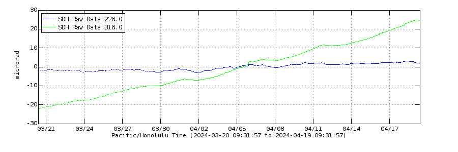
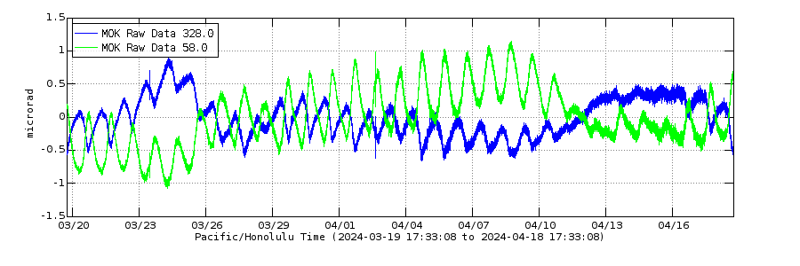
Kilauea with negative correlation compared with Mauna Loa since 18th February:
Kilauea
 ?fileTS=1772382239
Mauna Loa
 ?fileTS=1772382249
This looks as if Kilauea receives more magma at the moment and Mauna Loa supplies indirectly some magma to Kilauea. The next episode might be stronger than the last ones.
With unlimited geothermal energy and plenty of revenue from tourism and profitable industries I expect Iceland to become the worlds richest country before 2035 or 2040. GDP per capita is insane for Iceland well over 100 000 by 2026, putting Iceland nearly as high as Switzerland and more than twice as rich as Finland by the same economic rating and wages are nearly twice as high or more
Still Luxemburg, Liechtenstein and Switzerland are ahead but Iceland is getting very close
https://m.youtube.com/watch?ra=m&fbclid=IwZnRzaAREowpleHRuA2FlbQIxMQBzcnRjBmFwcF9pZAo2NjI4NTY4Mzc5AAEeiIk2RRY4mwLU05chjXP9A3GCJA8JE5t-1R5aVduJiaDzQVXebzBaW7jv-n8_aem_FnvdJWmPv4ezKlenKmMHZg&v=0mPrXQs2F9c&pp=ygUMaWNlbGFuZCByaWNo
Nice art showing an Ionian lava fountain filling an Ionian caldera pit. This is analogous to Halemaumau just that the fountain maybe
30 000 feet tall and the whole caldera system maybe 100 kilometers wide. The lava itself is 1600 c komatite
Does this site have any recommendations about viewing volcanos for someone traveling to Iceland. Love the content here.
My Russian biological motser have been found!!!!! and she is alive and active on internet born 1963 and her social media page on ok dot rus is active: I got help through insider experts But now the hardest challenge of all begins making contact with her through middle insider hands ( she haves to be well aware that a I found her well before i contacts her in person over the webb ) This haves to be Done in order for her to not get a stroke of supprisement or simply not beIive me I got this help so far by data breakers in Russia as in Scandinavia help is extremely limited Russian Adoptees and other insider information needs to reach out to her well before a I trys contact myself But finaly after 30 years she is found alive! and her Russian social media page is easy to access
Her name is Sveta Vykhodova. we got the last name quite correctly on your own guesses. Her ok.ru account where she is active her Russian social network. But but ok.ru that is her active account. She lives in Мончего́рск Monchegorsk
This is very exciting! but now insiders needs to let her know that I found her
Im my own on guesses and it was correct in the files too aftername
We will see how stage two will work with insider help
That is exciting news.
WE HAVES CONTACT!!!!! I will talk to her directly tommorrow over some of russian social media sites ( ok . ru ) finaly after 30 years 💕💕💕💕💕💕💕
She is intrested!!
Hopes ok.ru works in the west world it should do
Long time no see here, apologies for the long dormancy, but I’ve been working for a bit on a personal project (and things outside here).
A bit of the taste here.

More will come as I am working on them. May take a while to do…