
A fumarole near the rim of the pre-2018 Kilauea’s Halema’uma’u Crater, covered by a thick carpet of Pele’s hair produced by the lava lake. Moisture emitted by the fumaroles collects as tiny water droplets on the fine hairs, resembling a thin dusting of snow, photographed here, on May 28, 2017. (Source: Hawaiian Volcano Observatory / USGS)
Kilauea has become a different volcano. For 30 years, the summit was a passive participant in the seemingly ever-lasting Pu’u’O’o eruption. But nothing volcanic lasts forever, and 2018 was the year that proved this. A blockage near (or in) Pu’u’O’o caused the pressure in the rift to increase, the east rift gave way, and magma began to migrate eastward. Although no eruption happened at the summit, its subsequent collapse showed that the summit was an active contributor. We now have an entirely different volcano, and are lost as to what the future will bring.
But it can be hard to remember the past. Even the everlasting eruption had a beginning. Go back to before its beginning (and now we are talking 50 years ago), and you’ll discover a time when the summit erupted whenever it felt the need to release a bit of pressure. These were mini eruptions (compared to Puna 2018) but impressive nonetheless, and they happened in areas which now seem tranquil. One of these mini-events was the Christmas eruption of 1965. It is described in detail in an HVO report from where the following is taken.

With the 20:20 vision of hindsight, the event had really started in July with the onset of inflation inside Kilauea crater, just east of Halema’uma’u. (Remember Halema’uma’u?) Tremor began with little warning in the evening of 24 December, at 7:30pm. There was no time to prepare: the eruption itself began just two hours later. In those days, Kilauea could rival Hekla in speed of events, with barely an hour between the first felt earthquake and lava fountains appearing. At 9:30pm, a red glow showed that fountaining had begun, near Aloi crater, one of the craters along the Chain of Craters (it no loner exists). Observing the eruption gave some trouble to the Volcano Observatory observers. As HVO wrote ‘The observers rushed eastward along the Chain of Craters Road toward Aloi Crater, but were stopped about 500 feet west of the crater by dense clouds of sulfurous fumes and by ever-widening cracks in the road.‘ The observers could hear the eruption intensify, but not see it – until after 30 minutes a new crack opened and lava ejecta began to fall down less than 30 meters from where the observers were, convenient for the task at hand but not entirely safe. A retreat was in order, to ensure that the observers would not enter history as active participants.
The eruption declined after that, and by the time the observers finally managed to reach Aloi crater they could see the vents in the crater floor but the eruption there was nearly over. HVO wrote ‘The thin, continuous skin of lava that plastered the walls of the crater to a height of about 40 feet above its floor clearly indicated that much of the newly erupted lava had drained away before the observation parties were able to obtain a clear view of the crater‘. Kilauea had beaten the observers and managed to begin and finish an eruption unobserved, within 10 kilometers of the Observatory. The eruption continued in the forest to the east, but now rain and drizzle prevented observations. A final glow was seen at 4am, and the eruption ended at 4:10am on Christmas day. The whole event took place during the night and it was apparently not recorded in photos. The total lava output was less than 0.001 km3. This was a true mini-eruption, 20 times smaller than the one that happened in March 1965.
But the side effects were not minor. Cracks had opened over an 8 mile length, from the Kau desert to Kane Nui o Hamo. The Chain or Craters road was heavily damaged and became impassable. The width across the cracks was 1 meter. The cracking had occured during the eruption, and was largely complete by 4am. The summit had also been affected, and showed collapse, centred at the region where the inflation had been centred. The collapse was called ‘unprecedented’ at the time – in 2018 it would have been considered rather minor! But it was not only a collapse: tilt measurements showed that part of the south flank had moved seaward.

Hilani road
Earthquake activity had started two hours before the eruption, But it didn’t stop when the eruption ended. Unlike the eruption of 2018, the quaking continued to intensify, and remained high until 2pm on Christmas day. After that it decayed rapidly but it did not fully finish until December 31.
So what happened? Part of it was normal volcanic behaviour. Magma in the summit became over-pressured and took the easiest way out. That involved the rift zone. At that time, the path to the east rift zone was blocked, and eruptions happened in the rift close to the summit. Just like in 2018, the rift here must already have been close to failing. The intrusion pushed it over the edge, but instead of slipping in a single large earthquake, it gave way in a series of smaller shifts. The southern flank of the mountain shifted towards the sea. This caused the extensive cracking, which was seen over a much longer range than where the lava appeared. One may wonder whether the eruption caused the rift failure, or whether the rift failure opened up a magma path.
The eruption was brief and the rift failure had no immediate consequences. Previous eruptions had also been in the same rift region (slightly further east) and this fitted into a pattern. There were more minor eruptions in the following years, and a major eruption occurred in Halema’uma’u in 1967. But on May 24, 1969, the Mauna Ulu eruption began, which lasted for 2200 days (and also destroyed Aloi crater). This was the first phase of the Kilauea shield eruptions that over 50 years came to destroy so much of the southern coast. What caused this change in behaviour? Perhaps the opening of the rift on Christmas 1965 was part of the re-opening of the pathway, which had been closed since Kapoho 1960. And over the years, the re-opening continued opening eastward, from Aloi to Mauna Uu to Pu’u’O’o and onwards: this Christmas 53 years ago was a small step on the road to Leilani.
And also on the road to its end. The 2018 Leilani eruption ended with an earthquake in the area of the Koae fault of 1965. It seems to have closed the connection of Kilauea to the rift. The journey ended where it began – for now.

Hope
This all happened 53 years ago. Three years after this eruption, people would first fly around the moon. It was a time of hope when everything was young and anything seemed possible, when small steps for men became big steps for mankind. What happened to the hope? It is not only Kilauea that has changed. All around the world, society seems more divided than ever. The UK is particularly badly hit, and migrants (like me) perhaps feel less than fully welcome these days. Flying around the moon is a thing of the past: we can hardly get a rocket off the ground, whilst still using 1970’s technology. With all our progress, have we gone backwards? But volcanoes still erupt. They are a beacon of reality, and they are still able to surprise us. Volcanoes bring a different perspective.

The walls of the time
Memories are fading; our triumphs soon undone
The footsteps which today we make, tomorrow will be gone
But within us is the will to leave something that will last
a footprint on the river bank, before the current moves us past
as an outcast draws graffiti on a grey and wintry wall
as if to shout ‘I too have lived!’ beyond the empty hall
So I take what courage still remains, and in my feeble rage
I spray the word ‘Hope’ on the walls of this age.
Hearts are closed, unyielding, – with cold and empty eyes
Love surrenders where divisions erupt in fights
So much need and so much worry lies at our door
And when one child laughs, those that cry are ten times more
 The heavens turn away, their oversight has failed
The burden on my shoulders in weakness is travailed
But in despair and anguish, my sadness provides the stage
to spray the word ‘Hope’ on the walls of this age.
Madness is king, and around rises the tide
A world is breaking down, and yet I dream of light
We are lost in the darkness, but hope remains the key
Humanity returning in a future I do not see
One day, when on my grave the grass in wind is blown
The words ‘never forgotten’ have long been overgrown
Perhaps between the lasting shouts of bitterness and hate
also the word ‘Hope’ is on the walls of that age
Reinhard Mey: Die Mauern Meine Zeit

From all of Us to all of You
Merry Christmas and Happy Holidays!


In reference the ongoing Krakatau eruption and the speculation that the extreme height is due more to water related than to the ejecta rate:
From the abstract of “Moist convection and the injection of volcanic ash into the atmosphere” by Andrew W. Woods JGR Solid Earth – AGU 100 Volume98, Issue B10, 10 October 1993
“The increase in height is significant in relatively small sub‐Plinian and Strombolian eruptions in which mass eruption rates lie in the range 103 to 106 kg/s. In such eruptions, the latent heat released as the entrained water vapor condenses may provide the main source of heat which drives the ash and clasts upward. The height of rise then becomes relatively insensitive to the mass flux erupted at the vent and depends primarily upon the vapor loading of the atmosphere. In a moist atmosphere, ash may rise several kilometers higher than in an eruption of comparable strength in a dry environment.”
Note: 106kg/s is about 370 m³/s DRE.
So has it reached VEI 4 bearing that in mind?
How can even the VEI of a surtseyan eruption be calculated. The plume doesnt tell much as it seems to be driven by the water vapor condensing rather than the strenght of the eruption itself. The deposits from the eruption given the videos I have seen will mostly end underwater so I guess can’t be used either. The eruption is also quite complex as it had an initial dry phase before the collapse and surtseyan activity took place.
We can make an estimate. The collapse of a 400 meter high side of a mountain may have involved a block of 500 m by 500 m by 100 m (this tries to put reasonable but high numbers on). So perhaps 0.02km3, not all of which reached the water. The lava involved in the collapse generated the steam and ash, some of which may have been carried up by the steam. That gives a guess of at most 10% of the collapse volume, or at most 0.002 km3. In reality, it is likely rather less. That gives in terms of ash/tephra a source volume of less than 0.001km3. As it turns to ash, the volume triples (but in reality less as it wasn’t particularly dense to begin with). This gives a likely guess of VEI-2. The amount of water than turns to steam should not exceed the amount of lava (because of the ratio of heat capacities and temperatures) so that would perhaps double the amount. Of course, as water turns to steam it takes up a 1000 times larger volume – i’ll ignore that.
A study of Anak Krakatau predicts that a 0.28km3 is needed to give the tsunami height that was reported (4 meters). That is ten time higher than my estimate. I assumed that the top layer had slid down. Substantially more may be needed! That would increase the associated ash that is ejected into the air as VEI-3.
Even though it is a Surtseyan eruption, still 55,000ft for now nearly 60 hours surely must be getting it near the 0.1km3 mark by now…
So close to the equator is were cumulonimbus clouds grow the tallest in the world, this is because the inversion of temperatures being located higher up the atmosphere. The favourable atmospheric conditions are propably what is allowing this plume to be so high and particularly long lived. In other words I think the eruption is just producing a cloud with its upward growth driven by moist convection and behaving as a local thunderstorm would, just static and long lived.
Apparently the tallest cumulonimbus clouds of the world do seem to occur in northern Australia and Indonesia with cloud tops that can exceed 18 km high. I think the eruption is just providing a sustained source for moist convection to take place and is not a good indicator of the magnitude of the eruption.
That doesn’t mean the eruption hasn’t reached a VEI 4 volume, it was already erupting for a good few months, and really took off a few days ago, and quite possibly the collapse itself was caused by increased magma pushing through the cone. I don’t think half of an entire half km tall volcano falling into the ocean can be considered ‘minor’ in the way a VEI 3 implies (most VEI 3s are tiny compared to what anak is doing now). If surtseyan eruptions can be compared to continuous strombolian eruptions (basically a lava fountain) then my idea of 100 m3/s = ~50 meters fountain could be applied. This is best suited to Hawaiian eruptions as I made it to suit kilauea 1959, which would have a way higher rate than what anak was doing before, but with the clouds going about 500 meters high it so it still gives a volume of several hundred m3/s, which would reach VEI 4 in about 4 days.
Something I just realised after saying that, if kilauea iki did keep intensifying up to a basaltic plinian eruption (it was actually very close) then it would have been a solid VEI 4 of around 0.21 km3 of tephra. In hindsight, had HVO known the potential risk of that happening I don’t think they would have let people go so close…
Strombolian is more intermitent than hawaiian lava fountains and the lava is also more viscuous, I would say this activity consists in much lower rates than what you are giving to it. I have never seen evidence for a proper ash plume forming during the eruption, my guess is this was a VEI 3. But I think a VEI 4 or 2 cannot be discarded either.
Perhaps we could say that it is a moderate VEI-3 intensity eruption that lasts long enough to reach the VEI-4 boundary, like Eyjafjallajokull (regardless of the different types of eruption). Even if it only just reaches it, most VEI-4 eruptions are right at the low end- only a few end up in the mid-to-upper ranges of it and beyond.
Only 9 of the 19 VEI-4 eruptions between 1992 and 2015 had a volume of over 0.2km3 (equivalent to magnitude 4.3): Reventador 2002 (0.35km3), Chaiten 2008 (0.5km3), Okmok 2008 (0.25km3), Sarychev Peak 2009 (0.4km3), Eyjafjallajokull 2010 (0.2km3), Grimsvotn 2011 (0.8km3), Puyehue-Cordon Caulle 2011 (0.7km3), Kelud 2014 (0.5km3) and Calbuco 2015 (0.275km3).
Spurr 1992 and Kasatochi 2008 were 0.15km3, all the others were pretty much right on 0.1km3. I think that is a reasonable value to put on this event.
Albert, if your estimate is for the subaerial portion of the landslip only , you would need to add in a submarine portion too.
The water depth in this area looks pretty shallow. Does that impact the amount of material required to make a wave this size?
Tsunami hazard related to a flank collapse of Anak Krakatau Volcano, Sunda Strait, Indonesia
T. Giachetti, R. Paris, K. Kelfoun and B. Ontowirjo
Geological Society, London, Special Publications, 361, 79-90, 3 January 2012, https://doi.org/10.1144/SP361.7
Merry Christmas.
Etna is making some room for the Christmas turkey. Ashy eruption (Strombolian?) ongoing at the moment:
http://www.ct.ingv.it/en/webcam-etna-en.html
@#$@$!!! THAW the turkey first!
One day, we will realise that we have to live together on this fragile rock, and that building walls around ourselves can never be the answer.
When I was a child, my father told me that the people who worked for him in Malaysia (he was Regimental Sergeant-Major in the Gurkha Engineers) would take days off for Christmas, Chinese New Year, Eid, Dashira, Diwali and countless other religious festivals, irrespective of their own beliefs. They celebrated all of them equally, irrespective of their own beliefs. Well, when I say ‘celebrated’ I really mean ‘used the festival for an excuse for eating, drinking and being generally happy – and, of course, having a day off work. I suspect that the last phrase may have been their principal motivation, but I thought that it was nice anyway, and gave me an early unprejudiced insight into other cultures.
Merry Christmas to all VC contributors from an atheist and optimist.
Yep, the Nepalese (Gurkhas) in Hong Kong and the Cantonese from the civilian defense force, loved to celebrate everything. Ex RAF brat myself (good times)
This makes the assumption that people on the other side of the would be wall have ABSOLUTELY no wish to do you harm or pilfer from you. Until you have that, walls are necessary. Human nature dictates that someone out there wishes to either victimize you or do you harm.
Our local sheriffs department has a billboard campaign to remind people to LOCK their vehicles and to keep valuable items out of sight and secured. If there were no criminal element in society… that would not be necessary. Police exist for a REASON. To enforce the law. Walls are the same way. They establish a clear boundary around your “stuff” to keep it from walking away… and they add a measure of defense against predators and opportunists.
In my opinion, it’s better to have a wall than to shoot a thief on sight. That way they can carry on with their life and I don’t have to worry about them as much.
My grandson recently got an interesting letter from the Dept of Corrections letting him know that the guy who robbed he and some friends would be getting out of prison soon. Why do you suppose they have walls at prison? Because the guys on the inside don’t play well with others.
In keeping with my “Homo Stultus” idea…
Two Michigan women have been accused of stealing from a Target store that was filled with police at the time for a “Shop with a Cop” event.
And more Homo Stultus (specifically me)
I absolutely detest being jammed in a store with people. I’m fairly anti social. So, I tend to use the off hours to avoid crowds and traffic. It’s not that a fear crowds, I just don’t like them. One place that I usually wait until the super late hours to go to has added these to the parking lot. Mainly because this parking lot has a relatively high crime rate. The stupid bit is that I frequent this place in the way late at night time frame. The funny part is that there is a sheriff’s substation within 500 feet of where I took the photo.
Going a bit intense with surveillance? Yeah, but the area sort of demanded the attention. Not only is there a substation directly across the street, but there is a pretty active rent-a-cop that also patrols the lot. (Even before the at least two surveillance towers were parked here)
I respectfully disagree Geo, of course crime exists in every community but as the FACTS show most illegals are folks that overstayed their visas so they came in legally and the majority of those came in through Canada. No one is building a wall at that border. I live near that border and would be against that, we have taken our children and grandchildren to Canada on holiday many times.I don’t recall we want to ex-patriot every Italian because there is a Mafia. I’m of Irish decent and the IRA had a big foot print in the USA I wasn’t asked to leave.
What really puzzles me is this why are you so bothered by petty crime like a car being broken into but I never hear word one from folks about the white collar criminal who bilks us all of billions? ENRON, the savings and loan scandal, a war the world was lied into that cost billions and hundreds of thousands of lives over nonexistent mobile chemical labs and non existent yellow cake from Uganda, World Com accounting scandal, Bernie Madoff etc. no one gets a bee in their bonnet over those and we are talking trillions if I Listed them all.The difference seems to be they were all perpetrated by wealthy white folks no poor brown ones asking for asylum
It is hard to fight our prejudices and seek the truth, I struggle every day with mine. The point here is I struggle. I have a tendency to think of all southerners as false Christians with hateful hearts and black souls. I didn’t want to contribute to aid for their hurricanes after they way they treated Puerto Rico. I have to remind myself the South has some good people and they do not deserve to suffer because of some of their neighbors.I wish you a Happy Christmas and may Jesus install some love in your heart.
… and I never mentioned illegals… hmm…
As for being “bothered” by “petty” crime, I think it is within my allowed behavior set. I work for the funds to afford stuff I wish to have. Why should I be tolerant of ANYONE who wishes to deprive me of the usage of things that I worked for?
If you want to get into the esoteric side of it, money, whether it be hard currency or some Fiat script, is essentially a voucher for a certain number of heartbeats from a persons life. By stealing from me, a thief is essentially stealing the time and effort that went into trading the heartbeats I used while provided a skill that I sold to a party willing to pay me for those heartbeats.
Thieves, be they street thugs or government in origin, are essentially stealing life.
Additionally, “petty” is a relative term. What is “petty” to me may be all important to you. In the legal jurisdiction, “petty” has been co-opted as a definition for some monetary value, made by governmental “thieves.”
I know criminals are real. We see evidence of it everyday. The idea is to keep the criminals away from your stuff. That is one of the central reasons for walls. Better to keep them away rather than kill criminals on the spot. Walls are a more humane solution. Not only do they lessen the death rate of criminals, they lower the money wasted prosecuting them only to have them show back up on the street committing more crime.
A more effective/efficient but draconian solution would be killing them on the spot.
the wall in Germany is an example of failure to achieve the wanted outcome
True, but it achieved it’s intended purpose of slowing traffic. Where the wall failed is that it could not stop information. Eventually the “infrastructure” to maintain it failed.
(And no, I don’t think it was a good idea, my comment is only about its functional immediate purpose. Even the modern “Firewall” is only good if it can do what it was designed for.)
White collar crime? Strange, people seem to trot out that worn out pony every time they wish to bleat about some self perceived inequity.
I’m not giving them a pass, they should be stuck in the general population like anybody else rather than tucked away in a partially defunct military base under minimum security, mowing grass at the nearby bases.
Until you take down the corrupt governing entities that turned a blind eye or received a kickback, you will never solve the problem. I was quite please when 5 out of 6 of our county commissioners got their arses nailed to the wall when they were caught violating Florida’s Sunshine Law with some under-the-table shenanigans.
“On April 10, Childers was found guilty of two charges of bribery and unlawful compensation. Willie Junior was found dead under a downtown home’s front porch after a neighbor noticed a strange smell. His cause of death never really came to light.” The official cause of death, if I remember correctly, was that he drank antifreeze. Willie Junior has been in the Funeral Home business prior to serving as a County Commissioner. You would think that he would be aware of the painful death that Anti Freeze causes, yet it was ruled to be suicide.
sorry no latinos coming into the USA from Canada. Blame some other country please. It was a lie that the 9/11 crew came through Canada and still not acknowledged by some of the dumber US politicians. Please don’t start another false hood.
As far as I can tell, I did not bring that up.
If that is a personal issue you wish to discuss, this is not the place.
I have major issues with the USS Liberty, but I don’t trot it out because it will just be used to trash talk other people. My issue is the generalization that walls are somehow “bad.” People, through their actions, generate the need for walls. In my opinion, walls are a tool to lessen the need to shoot people and are therefore, actually a humane solution to a problem.
Jeez mr Grinch. It was just a call for people to come together regardless of petty cultural or religious differences.
Not one to throw caution in the wind and invite the crack addict on the streed over for dinner with your most fancy silverware.
Knowing the diverse background of all the people here. There is a good chance many of us talk here across rubble of long forgotten walls. Sure..I wont post my credit card records but that doesnt mean we cant mingle.
Nothing wrong with that. You see, the scary unspoken part about wall debates is that walls work both ways. A wall can be equally effective at keeping people in as it does out.
in times gone by the circled the wagons, then built castles, then wall around the cities and countries, the more things change the more they are the same
The point that I was trying to make is that people erect their own walls. A closed mind is a far more impenetrable wall than anything made out of bricks and mortar.
The origin of the wall and the manifest purpose is a very valid observation.
Each person builds their own.
I apologise for having triggered this discussion which was mainly showed divisions. That was not my idea. Reinhard Mey, who wrote the song, grew up in 1940’s Berlin and wrote this in the 1980’s: there is little doubt which wall he had in mind. In my personal opinion, no country can allow unlimited migration, and no country can survive without migration. Isolationism protects the past, but loses the future. And some people really are refugees: the Christmas story would have been much shorter had the Berlin wall been around Egypt. But it important not to project: whether people are southerner, northerner, liberal, conservative, city dweller or country side has very little bearing on how they are are with other people. One of the people I most admired was someone I met in Malawi: a retired butcher from the US who moved to a small village in the Rift Valley to try to help out. When we met he had no car as it was being used as the local ambulance (the real one had broken down). Politically and socially we had absolutely nothing in common. That seemed rather unimportant. It made me realize that in the stories, Jesus was a blue collar worker. If there was any wall between us, it was of my making.
Anyway, back to volcanoes. Why is Etna having earthquakes?
Umm…, Lawyers need a new lawsuit victim? They will probably try to pin it on a nearby organization with deep pockets.
http://www.meteo.fr/vaac/archives/ETNA/e.20181224140500.ETNA.201806.201812241400.html
ETNA
VA ADVISORY
DTG: 20181224/1400Z
VAAC: TOULOUSE
VOLCANO: ETNA 211060
PSN: N3744 E01500
AREA: ITALY
SUMMIT ELEV: 3330M
ADVISORY NR: 2018/06
INFO SOURCE: INGV, SAT DATA
AVIATION COLOUR CODE: RED
ERUPTION DETAILS: STARTED AT 1115Z
OBS VA DTG: 24/1500Z
OBS VA CLD: SFC/FL180 N3745 E01500 – N3730 E01640 – N3630 E01610 –
N3745 E01500
FCST VA CLD +6HR: 24/2100Z SFC/FL180 N3745 E01500 – N3710 E01735 –
N3605 E01635 – N3745 E01500
FCST VA CLD +12HR: 25/0300Z SFC/FL180 N3745 E01500 – N3725 E01755 –
N3540 E01655 – N3745 E01500
FCST VA CLD +18HR: 25/0900Z SFC/FL180 N3745 E01500 – N3735 E01730 –
N3550 E01635 – N3745 E01500
RMK: ASH EMISSION STILL OCCURS.
NXT ADVISORY: NO LATER THAN 2100Z
https://www.volcanodiscovery.com/etna/current-activity.html
New quake
https://www.emsc-csem.org/Earthquake/earthquake.php?id=734697
Magnitude mb 4.3
Region SICILY, ITALY
Date time 2018-12-24 16:50:13.6 UTC
Location 37.59 N ; 15.40 E
Depth 10 km
Distances 204 km NE of Valletta, Malta / pop: 6,800 / local time: 17:50:13.6 2018-12-24
178 km SW of Catanzaro, Italy / pop: 95,300 / local time: 17:50:13.6 2018-12-24
29 km E of Catania, Italy / pop: 314,000 / local time: 17:50:13.6 2018-12-24
Seismo
http://www.ct.ingv.it/en/real-time-seismic-signal.html
Station ECNE_HHZ_IT (Crateri Nord Est)
Amateur video Etna eruption.
https://www.facebook.com/kostas.tellis/posts/10215232236174223?hc_location=ufi
Nice find! Thank you.
And Stromboli has livened up too
That is anak krakatoa, in 2007, not stromboli.
Well it came from this story
https://www.infomessina.it/wordpress/?p=13577
and is called
It certainly looks like Stromboli as seen from the south.
I have to side with Bonnemort on this one. The image link even claims it’s Stromboli, and a reverse image search by Gurgle™ calls it that.
This looks indeed to be Krakatau. It is very common that volcano images are mislabeled. Google image search just looks at the tags, and only at very basic features of the image itself. It is not much help if the image itself is wrongly tagged. (In my more cynical moments I think that google does only as much as is needed to drive the competition out of business, and after that stops all development on the product. For instance, Google earth has become a lot less useful for us recently as historic images outside of the US are now presented at reduced resolution.)
In fact it looks identical to the picture of Anak Krakatau used on this website (near the bottom of page)
https://www.volcanodiscovery.com/stromboli.html
to illustrate Strombolian type eruption.
My guess is a journalist in a hurry picking the prettiest picture and not noticing it’s not of Stromboli itself. So turtlebirdman is proved correct.
A comparison between Planetlab images of Anak Kraktau taken in July and December this year. It shows how quickly the summit and west flank changed (and expanded). The summit expanded westward and so the slope may have steepened. This may have caused the instability. It seemed to have grown by 80 meters in 6 years. That is well above the average growth rate over its life (400 meter tall, plus 250 depth after the 1883 eruptions, over 135 years is about 5 meters per year). it is quite amazing how quickly volcanoes can grow. At Kilauea we are writing about centimeters of changes.. But it does explain why flank collapses are possible in volcanoes.
https://www.planet.com/stories/anak-krakatau-growth-may-dec-2018-l8JFjAsmg
I’ve always wondered if it ever really went quiet between 1883 and 1927.
It probably did, 1883 would have been quite a big hit to say the least, but obviously anak was growing before 1927 to reach the surface, it probably started maybe in the late 1800s early 1900s, maybe some 20 years after the 1883 eruption.
That points to a substantial and pretty continuous magma supply – which may be *good*. Hopefully the current surtseyan phase will continue relatively calmly, and the eruption will go back to subaerial in due course.
More dangerous might be if it paused or slowed with the vent(s) still underwater; that could give water easier access to the conduit, and lead to more explosive fireworks.
when it went in 1883, pictures from that time had multily vents which where erupting, they are most likely still there and will at some point be active again, it just let everyone know, he I am still here don’t forget me
“most likely still there”
No. The land where they existed is gone. Even the subterranean piping was destroyed as it fell back into the caldera or was lofted in a mass of pulverized rock.
The general thought on it (here in VC) is that a repeat of a large scale event can not happen until the floor of the caldera is resealed and is no longer easy to punch through. Anak and the current activity is just an infill event much like many Large Caldera Events have in their life cycle. ( I refuse to use the media fabricated term “super”, it has no definition in the literature. ) ← As a coping mechanism, VEI-8 is usually applied to them just to get a way of dealing with the contrived term. My definition of “large” calderas, would be those that are larger than the median size. Determining how large a median size caldera is requires measuring all known calderas, but at least the definition has a logical basis on reality rather than some hyped up superlative. “StuperVolcano has just as much merit as “Supervolcano.”
To be fair, anak krakatoa would literally fit inside kilaueas new crater without even reaching the rim, size and scale of growth is relative.
Anak krakatoa might have a total volume of a bit over 1 km3, after 91 years of growth, a rate of just over 0.01 km3 a year, which is low compared to Hawaii but pretty respectable for an island arc volcano. Most of that erupted volume also builds up near the vent so the growth of the cone is rapid, unlike lava flows in Hawaii, which while being fed at much higher average rates from depth also flow a long way and don’t stop near the vents.
Centimetres of change on a really big volcano might actually be far more than meters of change on a small volcano. Kilauea was quietly inflating at some 10 cm a year for the past 4 years, so slow it looked minor and was basically invisible, until it was at the highest level it had been in centuries and all hell broke loose. Now it is recharging all the same, activity will resume soon enough.
The thing I’m still waiting for is another paricutin-type event, a large scale cinder cone that forms a sizable structure and which did not exist before, then I can have a named and recognised mountain that is younger than me. So far fissure 8 is the closest to that and will eventually get a name, but 40 meters is not much to 450…
Apparently around 2014 Anak Krakatau had a volume of 0.32 km³ which means that up until that point it grew at a rate of 0.004 km³/year. When compared to some shield volcanoes it turns out not to be a particularly productive volcano. Kilauea has erupted at 0.067 km³/year (using the official numbers for 1823-2018), Nyamuragira at 0.036 km³/year, Mauna Loa at 0.018 km³/year and Piton de La Fournaise 0.01 km³/year.
Does that include the part underwater or just the subaerial cone?
Im also assuming the numbers of growth for all those volcanoes were for the entire period of observation in question, because as you know I found kilaueas recent eruption rate from about 1983 to now to be far higher than 0.07 km3/year, over 3 times higher in fact. The other volcanoes I know less about but they sound reasonable (I would have thought nyamuragira to be higher than that, most of its eruptions are pretty big).
I think in general subduction zones are not anywhere near as productive compared to hotspots, the biggest subduction volcanoes (which also seem to be shield volcanoes, like etna and ambrym) seem to top out around a few thousand km3 while piton de la fournaise is probably at least 20,000 km3 and the big island is 200,000 km3 and formed over less than 1 million years.
Well, the author of the publication was considering 0.32 km³ as the full erupted volume since 1930 to around 2014 but I dont think he was including any submerged volumes. If all of the cone has really been constructed outside the 1883 caldera then the number should be roughly spot on but if it has partially filled the caldera then I guess it could go up 0.1-0.3 km³ maybe. Still probably below the shield volcanoes I mentioned.
0.036 km³/year is a lot, there are probably not many volcanoes that can beat that number.
I estimated the growth rate of Kilauea using the 1823-present period which is the longest one possible, this one of course includes a dominant phase of Mauna Loa (1840-1950) so now that Kilauea is dominant over Mauna Loa the rate is currently higher.
I guess that the output of the hawaii hotspot is probably around 0.3 km3/year, with all of that being rupted when one of the volcanoes (nearly always kilauea) is open as it was until this year. I expect it wont take long to return to something like pu’u o’o but in a diferent location, probably either halemaumau or downrift from pu’u o’o
I think anak is growing from within the 1883 caldera, on the edge but not outside it, so the volume is probably a bit more substantial, but still nothing compared to a lot of bigger volcanoes.
The 1965 Christmas eruption is one of my favourite Kilauea eruptions. It might not have been very big, but the associated deformation was impressive, I can’t think of a better example of a Koae Fault System intrusion. Most of Koae cracked and faulted as the central area dropped up to 2 m while uplift took place south of the pali. There was a man evacuating out of ainahou ranch and as he was driving near the Kulanaokuaiki Fault saw a huge crack bursting open right in front of him and blocking the way to leave him trapped in the side of the island he wanted to leave. He and the ranch survived the event but Kilauea trashed a couple of roads that day.
There was a tiny eruption in the western end of the deformation zone too, deep in the koae faults. There is a volcanowatch article about it, and while it isn’t specifically said to have happened in 1965 that is the most likely year this could have happened.
It is significant that magma has intruded deep into the faults several times since 1950 but not really erupted there, my guess is because pu’u o’o is lower down, and now the open system is active even further down the rift, but if the lower section ever gets shut off then the increase in activity further up could lead to many more intrusions into koae, and sooner or later those will not be able to be contained. HVO has shown that they are somewhat expecting koae to become eruptive at some point. Another possibility is general relocation of the entire summit to within the koae faults, but that wouldn’t be an unnoticeable event.
As a response to the post itself, I have doubts this years quake did anything in the way of closing the rift off, currently the rift is showing the most change, especially from pu’u o’o down to the highway. At kilaueas supply now the most extreme long dormancy is about 5 years, and realistically is much less than that because an eruption doesn’t need to be anywhere near the size of this years event. This years eruption was huge, but 0.8 of the 1 km3 total deflation was taken up by a physical collapse which will not reverse, so the likely amount of time it will take to recover to the point of erupting is 1 year up to 2. The 0.2 km3/year supply would also mean that about 0.05 km3 was supplied during the eruption itself, which is a lot overall even if small in comparison.
Pahala says Merry Christmas 🙂
https://earthquake.usgs.gov/earthquakes/eventpage/hv70745446
M 2.2 – 3km SSE of Pahala, Hawaii
Time: 2018-12-25 20:53:50 (UTC)
Location: 19.177°N 155.464°W
Depth 32.1 km
A bit of a swarm at the summit of Mauna Loa. Several M2 quakes on the caldera, within the edifice.
I leant upon a coppice gate
When Frost was spectre-grey,
And Winter’s dregs made desolate
The weakening eye of day.
The tangled bine-stems scored the sky
Like strings of broken lyres,
And all mankind that haunted nigh
Had sought their household fires.
The land’s sharp features seemed to be
The Century’s corpse outleant,
His crypt the cloudy canopy,
The wind his death-lament.
The ancient pulse of germ and birth
Was shrunken hard and dry,
And every spirit upon earth
Seemed fervourless as I.
At once a voice arose among
The bleak twigs overhead
In a full-hearted evensong
Of joy illimited;
An aged thrush, frail, gaunt, and small,
In blast-beruffled plume,
Had chosen thus to fling his soul
Upon the growing gloom.
So little cause for carolings
Of such ecstatic sound
Was written on terrestrial things
Afar or nigh around,
That I could think there trembled through
His happy good-night air
Some blessed Hope, whereof he knew
And I was unaware.
Thomas Hardy, 1900
Thanks!
Thanks for the articles and Merry Christmas and happy holidays to all!
Mauna Loa has upped the altitude of its indigestion, with the three highest on the southeast/east edge of Mokuaweoweo
2018-12-24 17:41:46 1.8 -1.5
2018-12-24 12:38:39 1.9 -3.1
2018-12-24 03:54:13 2.1 -3.4
2018-12-24 03:45:53 2.6 -3.7
2018-12-24 00:47:14 2.3 -2.4
2018-12-23 22:38:10 1.7 -1.7
Mac
I remember a couple of years ago the active crater at Anak Krakatau shifted from the top of the cone to a new vent part way down the flank. I wonder if this might have contributed to the instability of the cone.
In a separate question, the old island had a number of volcanoes. Are there any other seamounts in the old caldera growing towards the surface?
Wishing Everybody the Best!, motsfo
You have a nice Christmas. I lurk but do enjoy your comments. In fact I enjoy everyone here who contributes. I wish everyone the Best also.
And best wishes to all this holiday season from the great white North!
Don “Big Noodle” Holland
Happy New Year soon
The Nene Geese dancing Numa Numa on Fissure 8
Nene flock dancing inside new halemaumau
Merry Christmas everyone 🙂
Happy Christmas and all the best for the New Year, volcano watchers!
Tuesday
25.12.2018 12:15:38 64.650 -17.480 3.3 km 3.1 99.0 2.5 km ENE of Bárðarbunga
merry christmas from bard
Merry Christmas and a very happy New Year 2019 to everyone here at VC, although here in Scotland and as currently part of UK, but if this brexit catastrophe happens, there might not be a UK for much longer.
NUK?
Has a certain 3 stooges ring to it… 😀
Merry Christmas and Happy New year to all here:
 Image of Chief Joseeph Mountain in Wallowa county.Zumwalt prairie in the foreground..
beautiful picture. Merry Christmas!
Happy New Year to everyone to all who venture here!
Very useful video, though a bit stupid to be there at a time like this! I have absolutely no doubts now after seeing this about the size of the eruption: VEI-4. Just.
Interesting. The video from Krakatau shows an eruption column rising from the old crater and large explosions rising from a location some distance off shore. That can’t still be coming from the collapsed material. Has a new vent opened? The volcano is going to look much different is this goes on.
I think that is a detached plume, still only one vent. But yes I agree that this is not a minor eruption by any means, it might not be plinian but it likely qualifies as a VEI 4 regardless, and the lack of a true eruption column is probably just because the vent is underwater.
Yeah you can see that the explosions stop momentarily. Plus it can be seen that a lot of material is floating around, just look at the state of the water at the end of the video! Still can’t quite believe they actually went there! It could just take a slightly more powerful explosion and a further collapse might happen. The surviving piece of the decapitated island can’t be all that strong….
It might have more than one vent. It reportedly did (multiple undersea vents or the appearance of that) in 1883.
Those other vents were destroyed in said eruption, the only part of the original island left is rakata, which was cut in two and possibly didn’t actually erupt in 1883. The other volcanoes destroyed themselves probably in part through a similar process as what occurred recently and only a dike on the edge of the 1883 caldera is left of one of them. Anak isn’t going to go VEI 6 now, it has so far been a typical young volcano in that it has erupted basalt and basaltic andesite at high temperature, causing its lava to flow rather than make domes, it is quite typical for such volcanoes to do VEI 4s, but not anything bigger. 1883 was dacite, which takes a long period of evolution to form, which in most cases means a long dormancy period of several hundred years or more.
In any case, the explosions in that video are from anak krakatoa. The cone to the left is rakata, and the remaining part of anak is hidden under the plume and partly beyond the horizon. If another vent opened outside anak then it would be deep underwater and take maybe years to surface and would have been discovered long before now (the area is also a busy shipping lane, the main rout between the indian and pacific oceans).
I still think that is a VEI 3 or lower. Surtsey 1963 was a VEI 3 and Nishinoshima 2013-2015 was a VEI 2. I don’t see the intensity of this eruption being very different from those two, and it has been going for a much shorter time. There are just a lot of water clouds developing all around and pouring down rain and lightning which makes everything look more ominous.
Here’s a better sattelite view. Anak Krakatau seems to have been cut in 2: https://twitter.com/annamaria_84/status/1077624443466338304?s=21
It seems that the collapse went from the summit westward. Most of the island is still there. That make the amount of collapsed material around 0.1-0.2 km3. Most of that ended up in the water of course. Seeing what fraction may have been ejected into the atmosphere gives at most a VEI-3. The mountain just did not have enough volume to support any bigger explosion. The steam column is for two reasons: hot material in the sea, possibly as debris pile reaching close to the surface, and pure heat from the exposed core of the volcano.
Where is the crater? Is it now submarine? She is still producing clouds to 55,000′ according to the latest VAA.
http://www.bom.gov.au/aviation/volcanic-ash/darwin-va-advisory.shtml
It also looks as there has been a lot more loss of the cone since the first set of satellite images on 23(?) December.
That is not impossible. The collapse may have left a very steep, unstable slope. It could be years before the cone stabilises again. There has also been a lot of rain recently, so expect continuous lahars.
That’s why it looks like 2 vents! Most of the cone including the vent is gone! The vent is now under water. The visible island is offset from the explosions. The work of 80 years gone in a couple of days. It will take decades to rebuild the cone.
That makes sense. Thanks!
Turtlebirdman!
Im in Big Islands now.. my favorite volcanoes and place on earth.
I come from Aritic Europe.
Im supprised just how hot Big island is even in december.
Even in Decemeber the heat in lowland Kona is unbearabe.
Despite Im 20 latitudes from the equator.
My question: do you knows what woud happen with Hawaiian temps of the Islands where at the equator just below. Even more unbearable?
No dry side on Kona if it was in equator?
It’s dry because of the trade winds, which are still there at the equator and the direction only reverses a way south of there.
I was in Goldcoast QLD AU 2 months ago and that is similar climate to Hawaii, and it was really pretty hot even though it was spring there and usually it is still more like winter at that point. It is more the sun than the air temperature, Hawaii gets direct overhead sun so it will be really intense.
You could just drive to the top of mauna kea if the heat is too much though, it snows there even in mid summer sometimes, I think it might be the highest spot on earth that is directly accessible from sea level within a day. You could also just go to the saddle, or kilauea, much more accessible and still really high up enough it can get near 0 in winter. One of those is definitely on your list already though… 🙂
You can’t ‘just drive’ to Mauna Kea. The road to the top is four-wheel drive only. You also need high clearance as there is sometimes a high ridge in the middle of the road. (Sometimes it is fine, sometimes not.) I have seen people who did not make it. Your rental car insurance also won’t cover you for that road. You can get to the visitor centre halfway up. And at the moment the road beyond the visitor centre is closed even to astronomers as it is covered in snow.
This is what can happen on that road if you drive too fast, easily done as the lack of oxygen seems to hit perception of danger. When going up, you need to spend at least 30 minutes at the visitor centre just to acclamatise a bit to the air.
The top is an ice age reserve. When you come down, once you hit the gravel road it becomes notable easier to breath – and to think.
Eh… it’ll buff out.
😀
It is still probably the highest point on earth you can drive to from sea level within a day. i thought it was relatively easy driving, I have only ever seen the news about the controversies of building more telescopes there and thought the road must be at least passable.
The Chajnantor plateau is higher, and reachable from Antofagasta in 4-5 hours driving. Antofagasta is a good place to leave. It is the largest city I know without a cinema and there was a nice fault running along the main airport runway.
I climbed up there in 20 minutes by car
No attitude sickness at all
But its beacuse Im so young and in prime health Im 23.
Had I been 70 the climb woud make me sick likley
I woud likley take Mount Everest with no problem given an oxygen tank
It is unpredictable. Sometimes it is fine, sometimes you get headaches and sickness. There seems no relation to how healthy or young you are .(very fit people have a high metabolism and use a lot of oxygen, after all. Friends of mine once got stuck in a cave on Tenerife. Several of them died due to air quality, including the fittest among them.) Mauna Kea is doable with acclamatisation but can be very dangerous if you go up from sea level directly to the top. People have died up there. There is a reason you are required to stop at the visitor centre.
Etnas flank eruption is ongoing… Becoming very noisy. There has been a very shallow 4.9 on the slopes of Etna, which did quite a lot of damage: https://www.timesofmalta.com/mobile/articles/view/20181226/world/ten-injured-many-out-on-the-streets-since-etna-eruption.697693
Furlough now in full legal effect. USGS accounts sending their last tweets. 99.1% of USGS employees not working – only 75 people at work.
https://twitter.com/search?f=tweets&vertical=default&q=usgs%20shutdown&src=typd
Due to the federal government shutdown, this account will not be active until further notice. More information at http://doi.gov/shutdown .
Just made this, a map of all the currently existing pyroclastic cones downrift of highway 130. Its pretty obvious but fissure 8 is the one in the middle of leilani estates, the pink cones are historical and the other cones are prehistorical up to very old (the hill that is now a kipuka with houses it it is over 1000 years old) but a few are from within 100 years of European contact (pu’u honuaula and kapoho cone, maybe halekamahina).
Some statistics of the new cones too:
Fissure 8: 411 meters wide, 40 tall, 70 meters above old ground.
Fissure 22: 100 meters wide, 50 meters tall above old ground.
Fissure 17: 180 meters wide, probably about 50 meters above old ground.
1960 cone: 700 meters wide, apparently over 100 meters tall when new but nearly gone now.
1955 kii cone: 300 meters wide but only 20 meters tall.
With this, it is very likely that at least fissure 8 and 22 will be named properly on account of their prominence and history, maybe fissure 17 too. Fissure 8 is actually bigger than I thought it was too.
Further up the rift there are much less cones, and a lot of lava shields most of which are historical. Before this century there were only really 2 actual lava shields, heiheiahulu which is about 250 years old and kane nui o hamo which is apparently 700 years old but could be twice that, but sustained ERZ eruptions seem to have become much easier in very recent time than before, which is interesting. What is also interesting is how cones seem to be almost entirely only on the ERZ, not the summit or SWRZ, and nearly all cones are on the lower half beyond pu’u o’o. This might suggest that eruptions on kilauea are changing to become more prolonged and likely to become single vents as opposed to fissures.
New official video
https://www.youtube.com/watch?v=WVrryGp_n-o
99 hours and counting now!
99 hours of Surtseyan eruption so far, buthow long was the Strombolian eruption going before the landslide &tsunami as that would be a more accurate portrait of the length of this current eruption on Anak.
She’s been active various paroxysms since the 18 June 2018. GVP have not published the report for this week yet.
http://volcano.si.edu/volcano.cfm?vn=262000#June2018
I think that goes without saying that I meant just this particular phase… 😛
More Krakatau video posted 12/26
https://youtu.be/eUQU56ESpKs
Krakatau from the shore again:
If anyone here speaks Indonesian, they have a geologist on this talk show:
(Rant alert)
Sounds like they finally raised Anak to Orange alert….. 4 days late and not to Red, plus an exclusion zone of only 3 miles! It should have been put straight to Red as soon as this started. No acknowledgement of the high ash plumes in the VONA archive either. Not impressed by their response to events this year (quite a bit of criticism from Indonesians too, also about the Palu tsunami and that they still don’t have a reliably-functioning tsunami early warning system- it’s the 14th anniversary of the “big one”- 230,000+ dead and still an inadequate response!). Plus their website hasn’t even updated to show Karangetang at Orange and Dempo down to Green (a month ago, only found out the other day) and on the Magma site Anak still shows at Yellow and Banda Api shows Orange even though it wasn’t raised. And then there’s quite a few other volcanoes that have significantly quietened but the alert levels haven’t been changed- particularly Gamkonora which looks completely quiet. I know it isn’t easy for them but I think their standards have dropped quite a bit lately. They can and usually do better as shown by the responses to Merapi, Kelud, Sinabung (initially) and especially Agung a year ago. I don’t know, maybe it’s just me but I would expect all disaster agencies regardless of where they are and level of funding etc. to be on the ball straight away…
The other volcanoes are well monitored and give off clear signals about increasing in activity. Anak was involved in a rather sedate (but active) eruption and no one really expected about half the thing to slough off into the sea. That’s not typically seen with this volcano. It’s the sort of thing that the Canaries look for all the time and are geared for in their monitoring network, just based on the large number of slide scarps they have on the islands. With Anak, it’s hazardous to go install and maintain the GPS stations that would be needed to detect that sort of threat before it happened. It likes to throw rocks at you. If you wait and try to detect the slide with seismic gear, you’re probably not going to know about the slide until it is in progress, and even then, it would probably look like some sort of tremor signal.
Delays due to the Christmas break? Or what do they base their assessment on? It does seem odd that Sinabung is on red but Anak Krakatau is only orange. However, Anak Krakatau’s earthquake level seems to be remarkably low for an erupting volcano (unless the graphs have not been updated).
https://magma.vsi.esdm.go.id
pretty sure they dont have a christmas break in indonesia as its a muslim country.
There is a paper in Nature, fairly recent, showing that Sinabung has access to the Toba magma system. Maybe that is why it is red?
Sinabung is very active. Check out the plot of recent seismic activity on the page for Sinabung:
http://webcams.volcanodiscovery.com
https://magma.vsi.esdm.go.id
Tsunami risk from landslip was predicted 6 years ago.
https://www.volcanodiscovery.com/krakatau/news.html
A couple of years ago the BBC had a documentary which looked at the 1883 tsunami from Krakatau. It include a demonstration from Prof Iain Stewart (?) of how increasing pressure in the volcano could cause slope failure. Been trying to find the documentary but not successful as yet.
Here’s the citation for a paper that predicted the basic framework for this event with remarkable accuracy.
Tsunami hazard related to a flank collapse of Anak Krakatau Volcano, Sunda Strait, Indonesia
T. Giachetti, R. Paris, K. Kelfoun and B. Ontowirjo
Geological Society, London, Special Publications, 361, 79-90, 3 January 2012, https://doi.org/10.1144/SP361.7
The aviation code is red and has been for some time.
http://www.bom.gov.au/aviation/volcanic-ash/darwin-va-advisory.shtml
Yes but only from the VAAC. Technically not official.
People are being advised to stay away from the shoreline at the moment – about 500m to 1km away and 20,000 people have been relocated.
I am guessing that the main hazard is seen as a tsunami from possible landslips. But can Anak Krakatau produce pyroclastic flows at the moment?
Source for the 500m – 1km bit. https://www.straitstimes.com/asia/se-asia/indonesian-tsunami-torrential-rains-pound-villages-hampering-aid-efforts-in-coastal
This picture on the Photovolcanica site is quite interesting as the 1883 caldera perimeter seems to follows exactly where the scarp of the mass wastage event is. This ties in nicely with Merlot’s observations above.
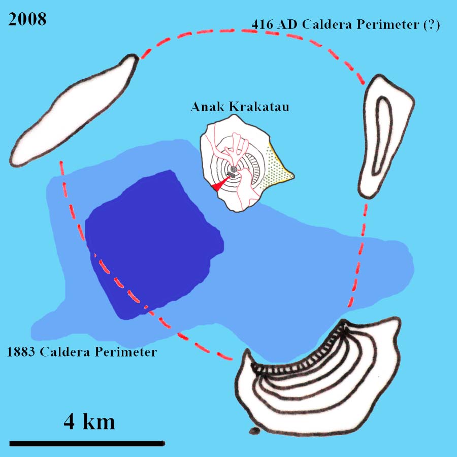
Yes, it collapsed towards the steepest decent. The depth though was measured quite a long time ago and it is unlikely to still be as deep. Also ignore the text ‘416 AD’ which is a myth. The caldera is likely far older than that and may not even be a single event. For instance, it runs through the summit of Rakata which became a caldera edge only in 1883.
My guess is that 416 event was real but the evidence has been wiped out / buried by / confused with subsequent events, assuming that the event was Krakatau. The description is consistent with the 1883 eruption and also current events.
But the 416 caldera perimeter in the image above is less likely, not least because the south east edge on Rakata is the remnant of the 1883 eruption, which is more likely to reflect the lava types, how the edifice had built up and its structural weaknesses.
* SE edge of the dotted line; NW edge of Rakata
Something I have noticed after looking at the most recent etna update, it has been 350 years since the last low altitude eruption there, while they used to happen pretty often before that point with a number of eruptions beyond the main cone between 1000 and 1669 (about 9 I think). The recent quakes are some way further away from the summit than the new vent and quite deep, and trending beyond the valle de bove. I think etna might become a pretty interesting volcano in the near future, it has a continuously active summit crater complex and frequent subterminal eruptions like now, but apart from 2002 which was still near the summit, there has not been an eccentric eruption since 1669, and no eruption beyond the cone itself since then either. There are many historical cones (including 1669) that are now within inhabited areas, and a big eruption like that would be far worse than kilaueas recent analogous eruption on account of the population density and historical architecture (roads are not car friendly etc). In the past 25 years etna has thrown some impressive eruptions, 1996-1999 and 2015 were some of its biggest ever and 2002 was a powerful flank eruption that was a lot bigger than most others, and that along with the recent growth of several of the summit craters very fast shows a prodigious magma supply probably far above average among subduction volcanoes. 1991 was allegedly the last big drain but after previous terminator events not much happened for decades afterwards while big eruptions happened within a few years of 1993 so I think the true terminator of the current active period has yet to happen and could be a lot bigger and maybe fairly imminent. The 1600-1669 period included a number of large eruptions including a long lived eruption like 1991-93 and ended with a very big flow some time afterwards, 1669 also created its central crater which wasn’t filled until the 1950s but has since overflowed many times and built up a large crater complex which are all very active, another sign of high supply now, and this has also erased the previous piano de lago caldera from 122 BCE. This could mean even another caldera eruption is possible, the problem is that unlike kilauea, etna doesn’t typically do passive caldera collapses…
Really it’s only a matter of time before a vent opens in a village, and if 1669 is a base model then all hell could break lose after that.
Maybe an etna post is in order, for being such an active volcano there isn’t much on it here at all, kind of like Hawaii before this year I guess.
Maybe I’m a bit eurocentric, but Etna already is one of the most interesting volcanoes on the entire planet. No need for it to “become interesting”. First, there shouldn’t be a volcano at all where Etna is. Second, yet it is almost constantly active. Third, it produces almost every eruption type there is, among those the biggest lava fountains of any volcano. It also had way more eccentric eruptions than you mention.
If it’s still available somewhere….many moons ago Boris Behncke, who is THE go-to expert on Etna, did a comprehensaive 3-part geological history of Etna on, I recall, Erik Klemetti’s ‘Eruptions’ blog. Worth looking for
Found it. . Three parts: http://blogs.discovermagazine.com/rockyplanet/2010/08/16/etna-week-part-1-brief-anatomy-of-an-exceptional-volcano/#.XCVDA2S1LN4
http://blogs.discovermagazine.com/rockyplanet/2010/08/18/etna-week-part-2-the-current-dynamics-and-activity-of-etna/#.XCVDXmS1LN4
http://blogs.discovermagazine.com/rockyplanet/2010/08/20/etna-week-part-3-etnas-volcanic-hazards/#.XCVDfWS1LN4
I have read all of those, actually where I got a lot of my info. However these are pretty old now and don’t include some of the newer stuff like the 2015 episodes.
Also, in the context, eccentric eruptions are not the same as flank eruptions for etna. Most of its flank eruptions are subterminal eruptions fed from lateral dikes extending from the summit conduits, this includes 1991, and this year too. A true eccentric eruption is when a new dike moves up from the main source and is not connected to the summit feeders. This is what happened in 1669, it also happened in 2001 and 2002-2003, and after writing before it also happened in 1974. Eccentric eruptions are the eruptions that tend to make cinder cones and are basically summit eruptions but not on the summit, subterminal eruptions only really make lava flows because the vent is connected to the central conduit which will degas the magma.
On this topic, I just read that even the officials at INGV are putting a warning of a low altitude flank eruption on Etna in the near future
Ah alright, I wasn’t differentiating between eccentric and true flank eruptions.
Well both are true flank eruptions, they both happen on the sides of the volcano, but there is a big difference in eruption style between the two, and subterminal eruptions are not associated with lack of summit activity rather the opposite in many cases. Eccentric eruptions are often also very explosive and have high fountains not unlike the summit paroxysmal eruptions, creating large cones many of which are visible in inhabited areas…
In the present situation right now, I think the idea is that a possible eccentric eruption might be about to happen quite far from the summit in an area where it would be a real problem if it reached even 1/3 the size of 1669 (1669 was over 0.5 km3 of lava in 4 months, an impressive lava eruption rate and probably unlike anything seen since then outside the summit eruptions). In effect it is the exact situation mentioned in the last of Boris’ articles. I might be wrong in that, but it is my interpretation. I suspect if anything does happen though it will not happen suddenly and will not go unnoticed for long at all.
Krakatoa is clearing erupting from a new vent offshore. This is becoming interesting. Water may actually have entered the caldera again.
But I think the odds of a new 1883 are low, considering that only a bit more than 100 years have passed.
At most it could cause a VEI5 event.
Krakatoa may have at least 1500 years between very large (VEI6+) eruptions.
The 1500-year period has no scientific back-up. It is likely longer than that.
There may be a vent under water, but I expect it is exposed magma that cascaded down rather than a new vent. Wait and see. It may be some time before the heat is low enough to actually see the left-over mountain again!
Since we love naming things.
I propose the name Cucu Krakatoa if it becomes its own mauntain/island
Nice one! But ‘Krakatoa’ is an english name, originating from a typographical error. The original name is Krakatau (crab), so it becomes Cucu Krakatau. ‘Zoea Krakatoa’ might work.
The locals call it Gunung Anak Krakatau (or sometimes Anak Gunung Krakatau).
I thought so to begin with but subsequent footage would suggest its the same vent just missing a large portion of cone/island flanking it. Expecting Anak to do a “Bogoslof” style landscaping with some new temporary features that the sea will erode away as it rebuilds itself over time.
^^ Reply to irpsit 🙂
https://www.forbes.com/sites/robinandrews/2018/12/27/anak-krakataus-alert-level-has-been-raised-heres-what-that-means/#26b240676471
hello everyone . Iceland just had a 5.4 mag not sure if this a real quake or a computer error .
Thanks Jack. The system puts comments by new commenters into a ‘pending queue’, also called ‘the dungeons’. It needs approval by an admin. After that, further comments should appear without delay (unless it falls foul of other rules, such as too many links in the comment or too many comments within too short a time). Sadly, this rule is needed to protect us against space invaders. You are hereby released from the dungeon. An admin
also Bárðarbunga just had 4.8 mag .1km depth .
the 5.2 mag has been remove but the 4.8mag still there
https://www.volcanodiscovery.com/earthquakes/quake-info/2209775/M4-Fri-28-Dec-Iceland.html
https://en.vedur.is/earthquakes-and-volcanism/earthquakes/#view=table
Iceland:
Friday 28.12.2018 01:46:18 64.670 -17.419 1.1 km 2.8 90.12 6.1 km ENE of Bárðarbunga
Friday 28.12.2018 01:38:17 64.666 -17.417 1.1 km 3.2 90.16 6.0 km ENE of Bárðarbunga
Friday 28.12.2018 01:20:19 64.667 -17.443 0.1 km 2.8 99.0 5.0 km NE of Bárðarbunga
Friday 28.12.2018 01:16:33 64.664 -17.451 0.1 km 4.8 99.0 4.5 km NE of Bárðarbunga
https://en.vedur.is/earthquakes-and-volcanism/earthquakes/vatnajokull/
And:
Friday 28.12.2018 01:16:15 65.191 -20.263 10.8 km 5.4 45.85 47.0 km N of Eiríksjökull
The 5.4 is nowhere near Bardabunga. It can be found on the map for Langjökull.
https://en.vedur.is/earthquakes-and-volcanism/earthquakes/langjokull/
OTH if you look at the drum plots, the 5.4 might be a tad closer to Bardabunga.
http://hraun.vedur.is/ja/drumplot/allarsort.php
The 5.4 has been taken off the maps; perhaps the 4.8 confused the system.
The rest now have depths:
2.8 1.4km
3.7 2.6km
3.5 0.1km
4.8 0.1km
Surpirsed to see the very shallow depths. Those strong quakes in this place use to be from adjustments of the “plug” and several km down. Wonder what explanation Tomas may have on these. Could he fit these into his model?
I’d say the timing and size is just as expected. I said some time before christmas that I expected one of the larger quakes to happen within one or two months. Nothing strange about the shallow depth. The hypocenter just tells us the location of the initial break but the fault extends both wide and deep. Hypocenters along the ring fault usually have depths between 0-10km. Compare with the large one in June and you will see a similar depth distribution.
The quakes are all at Bardarbunga. They are tectonic, with a little reverbation. I am not sure what causes the reverbation but it involves much of Iceland: it may be a reflection of the moho or of the edge of the continental shelf.
Do you think the somewhat special waveforms from Bárdarbunga’s quakes may be because the fault has a complex geometry? Before the eruption, there were a number of papers analyzing the anomalous M5 quakes. There are two main models: the one with rapid magma movement between two chambers at different depths and the one with complex shear faulting along the ring fault.
Personally, I favour the model with complex shear faulting, since that is consistent with what we could observe during the eruption. The difference being that the collapse quakes during the eruption had moment tensor solutions with reverse polarity, indicating similar movement but in the opposite direction.
I have seen papers that model the large earthquakes as a rapid succession of smaller planar faults that together form a steep inward dipping conical fault. Those models give synthetic waveforms that are quite consistent with the observed ones. From hypocenters of the eruption quake sequence we now have a better idea of what the ring fault may look like with inward dipping on the south side and a slightly steeper outward dipping on the north side. It would be interesting to see someone model the ring fault quakes using that geometry instead of a symmetric inward dipping cone.
https://www.volcanodiscovery.com/etna/news/72609/Etna-volcano-update-Decreasing-activity-for-now-but-this-could-change-soon.html
Mention of possible future eruption that could happen in the piano de vescovo area, due south of the recent activity and close to inhabited areas. Maybe what I said in the original comment above could just be about to be answered…
If an eruption happens low down then there could be quite a long flow, as well as the eruption lasting a long time maybe even years like 1991-93, if it is deep sourced then significant cone formation and tephra is likely before any lava flows, very interesting situation and one to be watched closely, if the officials are interested it means something is happening now that hasn’t before.
Near Bronte in Etna, there is a totaly massive Pahoehoe flow field
That was erupted during a very slow many years long eruption with fairly fluid basaltic lavas.
The lavas are known as pea lavas as that pahoehoe contains some large crystal phenocrysts.
That lava was fairly fresh but had sat in the ground a bit before erupting.
These are still one of the most pure forms of pahoehoe on Etna look at Google Earth.
Pure pahoehoe it was true pahoehoe. But it was not as fluid as Hawaii.
The Bronte pahoehoe flow field contains large lava tubes and numerous tumulus mounds.
Etnas lavas are fluid enough for lava tubes and some pahoehoe.. but its never as fluid as the more hotspot origiated basalts like Hawaii and Iceland.
Bronte is the only recent true pahoehoe flow field on Etna: almost all others are Aa lavas fast eruptive rates and etnas higher basalt viscosity.
1669 was hot and fluid too.. and did produce some pahoehoe as the eruption slowed down and formed crusts and tubes. Alot of the later phase of 1669 was pahoehoe.
Etnas fluidity depends very much how fast the magma rises from astenosphereic source
If it rises faster there is less diffrentiation, if it rises slower there is more diffrentiation on the way up.
These days Etnas magmas are supplyed quite quickly and are generaly basaltic and mafic.
Hotter subduction zone magmas you finds in Ambrym, Masaya and Villaricca who appears to get magma extremely suickly from magma source
Etna haves a lava with a viscosity thats very similar to Pacaya basaltic lavas
Videos of Pacayas lavas and spatter and flows are identical to Etna
All of etnas recent cones (recent enough to be barren).
The yellow is cones between 1669 (the one at the bottom) and 2000, though only 1974 is younger than the 19th century.
The orange are cones formed in the 2001 and 2002-03 eruptions, and also I think in 2014, and the red is the active summit complex as well as this weeks fissure which is apparently already inactive. All of these eruptions save this year might have been eccentric, 2001 and 2002 definitely were, and so was 1974 and probably 1669. Eruptions that originate as lateral intrusions from the summit conduit are often completely effusive and build only small structures, or none at all like this year. 1991 was probably a very large lateral eruption, as after a number of big eccentric eruptions the volcano has been relatively inactive for decades afterwards but this was definitely not the case with after 1993, when the biggest phase of summit activity on record and then two powerful flank eruptions happened within 10 years and have barely slowed since then.
The area at risk of having an eruption as of recent is the faded red area, it is called the piano del wescovo as mentioned above, and this could very easily (it is almost certain really) send a lava flow into inhabited areas, there is even a steep slope at the edge of this area which would make it even more likely. Like kilauea, etnas intrusions dont seem to be final acts, and an intrusion into this area could result in an eruption there at a later date, there was an intrusion in 1989 that was exactly where the 1991 eruption later happened, 1991 was actually exactly on the line of this years fissure, and in the early part of the 1991 eruption it was deemed likely that eruptions could happen further downslope in the same area as now although that never happened. An eruption in 1792 also happened here, it was like 1991 in that it seems to have been slow and has many lava tubes. The recent quakes seem to indicate a deeper level of activity though so if anything does happen it isnt likely to be as gentle.
In 2002 the eruption also began after about a months of quite following summit draining and so this could be a tense start to the year.
An monogenetic flank cinder cone eruption like 1669 near the same place woud be a material disaster beyond imagination if it happened today! The costly damages beyond imagination.
That isnt really too far out of what might happen now, a low eruption on the red area wont go near Catania but unless it is almost impossibly small or has no lava at all (both really unlikely) then it will become the second time since 1669 where a village or two gets destroyed (which is actually impressive in its own right)
Prof Dave Petley on the Landslide Blog’s done an interesting post on another set of volcanic landslides:
https://blogs.agu.org/landslideblog/2018/12/28/chaos-jumbles/
Stumbled in facebook (account Erlang Erlangga via Jacky Pomeroy, who still is reporting about Agung) across this scheme published by Chiba University Japan.
I have no idea from what report the scheme comes.
It comes from this research presentation I guess.
https://slideplayer.com/slide/2358143/
by Josaphat Tetuko Sri Sumantyo.
A few good videos and pictures of Etna on this twitter site
https://twitter.com/hashtag/Etna?src=hash
Also Boris Bencke’s twitter
https://twitter.com/etnaboris
The major activity finally stopped. In the region of 135 hours just about non-stop. Hopefully we’ll get a clear image of the island- reports that it has gone from 338m (1,100ft) high down to 110m (360ft). Basically a miniature version of Rakata.
Not sure you can say activity has stopped. The ash cloud was last reported at 10,000′ and activity is strombolian.
http://www.bom.gov.au/aviation/volcanic-ash/darwin-va-advisory.shtml
Most of the earlier plumes to 55,000′ were gas (steam?), not ash. According to Darwin VAAC they lacked the spectral signature for ash.
Think it is a case of wait and see.
I did say major…
OTH Darwin VAAC now says no ash is visible so the current phase may have ceased for now but clearly Krakatau is being closely monitored. Aviation code is still red.
http://www.bom.gov.au/aviation/volcanic-ash/darwin-va-advisory.shtml
Protoplanetary disks on parade.
Roughly equivalent to the pre-Hadean phase in Earth’s development. (and also the source of much of the heat energy still driving our volcanoes… augmented a bit by radioisotopes seeded into our nebula by nova and supernova.)
Anyone interested in the New Horizons flyby of Kuiper Belt object Ultima Thule (2014 MU69) should note the Johns Hopkins Applied Physics Lab will be taking over from NASA tv to cover the event live during the government shutdown.
http://pluto.jhuapl.edu/News-Center/PI-Perspectives.php?page=piPerspective_12_27_2018
https://www.bbc.co.uk/news/science-environment-46707731