We, humans, are ingenious at finding smart ways to do the impossible. Regarding volcanic eruptions scientists have found a way of figuring out when large volcanic eruptions occurred with incredible precision, large explosive eruptions from anywhere in the world, by looking at ice none less, who would have guessed that? Combined with high-precision geochemical studies you might even find the volcano responsible, although this is not always the case. Learning when large eruptions happened is apparently easier than finding the volcano that made them. There are a bunch of eruptions that we know when they happened, but not where. Among them, there is the mystery eruption of 1808, which I hope I might be able to make into less of a mystery.
In 1808 a large eruption scattered a cloud of volcanic sulfate aerosols across the world, into both hemispheres, depositing the sulfate in both Greenland and Antarctica. Albert is the expert when it comes to volcanic aerosol clouds so I will leave a link to his article on the 1808 eruption at the end that explains many aspects of it better than I could:
I will just mention a few important things for this article. The eruption is thought to have been very large given the major sulfate spike. It must have happened in the Tropics, probably south of the Equator judging from the dispersal of the cloud. There are witness reports, from Peru and Colombia, that describe a haze that obscured the sun in a manner akin to Saharan dust, a pale sun when low on the horizon, and which place the eruption in December 1808 or earlier, which is when the haze first appeared.
There are no historical reports of the eruption itself, however, which is puzzling. Tambora in 1815 was recorded to have been seen and heard by many, yet the eruption of 1808 went completely unnoticed. Which volcanic areas are found within the Tropics that have the potential to produce a large explosive eruption? We have the Central American Arc, the North Volcanic Zone and part of the Central Volcanic Zone in the Andes, the East African Rift, the Sunda Arc, the Philippines, the Bismark Arc (Papua New Guinea), Vanuatu, and the Tonga Arc. That’s a lot right? The thing is that historical records of volcanic eruptions in most of these places go centuries back. Most of these places can be discarded right away based on the existence of those historical records, many can be discarded based on geologic evidence that there were no large eruptions during that time.
The East African Rift is remote, but there is a vast amount of scientific studies, and such an eruption there would have probably been found. Lava flow eruptions of Kone and Fentale, in the Ethiopian Rift around 1820, are reported, so a much more impactful explosive eruption would have probably been written about. Much of the eastern half of the Ring of Fire was part of the Spanish Empire and eruptions were being reported during this time. Sunda was watched over too, as demonstrated by Tambora. All possible candidates I can think of from Vanuatu have been researched, as well as those from Papua New Guinea. The island of Bougainville is one of those places where a massive eruption may have gone fully unnoticed and has a lot of potential for major eruptions. Two volcanoes on the island are surrounded by vast aprons of pyroclastic flows and feature a small summit caldera, the kind of volcano you are normally looking for, but both are well-researched, and their last major eruptions are dated. Finally, there’s Tonga, I used to consider this the best place for the mystery eruption to have taken place, there are calderas all over the place here, but they are underwater. The two subaerial/partly subaerial calderas are studied (Hunga Tonga and Tofua), the rest are all underwater. Usually a few hundred meters underwater. This may pose a problem, since Hunga Tonga, which was an underwater eruption, failed to emit any meaningful amounts of sulfur dioxide into the atmosphere, in fact, its SO2 release was like a VEI 4 eruption, pretty ordinary. Sulfur dioxide later turns into sulfate, and thus Hunga Tonga will have probably failed to leave a sulfate spike in the ice records. The rest, even deeper underwater, calderas, may have faced similar difficulties in sending SO2 into the atmosphere. Not to mention there may be a high likelihood that someone would have heard the explosions or some ship gotten caught in the ash fall.
So where did it happen then? I may have found a very good candidate. A remote volcano in the Andean Altiplano, in an arid deserted region 4 kilometers above sea level, pulled off an eruption that was very big, but very weak. Tambo Quemado.
Edit: Searching the VolcanoCafe comments after publishing the article I found one earlier mention of Tambo Quemado from cbus05, who said that Tambo Quemado was his best possible candidate in the Andes for the eruption of 1808. This comment was in 2016, before I arrived at VolcanoCafé, so I don’t think I could have read it before. That said I must note that cbus05 was the first person to suggest Tambo Quemado as the 1808 candidate, at least to my knowledge.
Tambo Quemado yields no results when searching in Google Scholar. The only written information I’ve seen is the Global Volcanism Program’s description, which itself quotes personal communication, or previous catalogs of volcanoes as the source:
“A low pyroclastic shield near the Rio Lauca forms Cerro Volcán Tambo Quemado on the Bolivian Altiplano. The extremely youthful-looking volcanic complex (also known as Cerro Quemado or Volcán Sacabaya) displays fumarolic activity and is estimated to be of Holocene age. It consists of a broad ignimbrite shield capped by an elongated NNE-SSW-trending vent area about 2 x 3.5 km in diameter formed by three large overlapping craters. The youngest crater lies at the southern end of the summit region and contains a blocky lava dome. The wind has redistributed tephra deposits to the E and S, forming aeolian sand dunes”
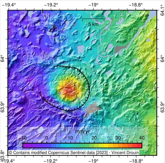
Tambo Quemado is in between two major clusters of stratovolcanoes, north is a family of giants that includes the beautiful Sajama and Parinacota volcanoes, the latter, Fuji-like volcano, has been vigorously active in the Holocene. To the south lies a smaller group, that hosts the historically active Isluga, and the very young-looking Augustine-like Tata Sabaya, which, despite collapsing into a huge debris avalanche, later managed to rebuild a very symmetrical cone. Tambo Quemado on the other hand is a low volcanic edifice in a valley, GVP describes it as an ignimbrite shield, although I prefer a tuff cone. It’s relatively isolated, although 30 km south there is a circular massif that might be important as we will see.
The landscape all around Tambo Quemado is covered in ash, the tuff cone itself is gigantic, vast fields of ash dunes extend downwind of the tuff cone for tens of kilometers, and a bright pyroclastic mantle that drapes mountains to the north and south. Overall this area can be seen in satellite images as a big grey blur, perhaps some 50 by 80 km across. The effects on the landscape are dramatic enough to bring attention to this forgotten volcano.

Sentinel natural-color image of the Tambo Quemado area. The grey area is the pyroclastic imprint of Tambo Quemado which is very clear in satellite images, with the exception of Huaynaputina there are no other air fall tephra deposits of this size that are clearly visible within the Andean Altiplano in satellite images. The black spot to the NW is the mafic Parinacota volcano. Another dark, grayish spot near the bottom of the image, south of Tambo Quemado is the Isluga volcano. White areas are salt flats, Salar the Uyuni is also close to here, the largest salt flat in the world.
The tuff cone and the cryptodome
Let’s start with the tuff cone. I have inspected the volcano on Google Earth. Tambo Quemado has a complex of craters nested atop a shallow-sloping cone, all features are extremely youthful looking. An outer crater complex measures 4 km long by 2.5 km wide, another crater complex of 2 by 1,5 km is nested inside, and a vent on the southern end of the nested craters erupted a short, viscous lava flow some 200 meters thick. The flow is a of bright brown colour, which if I had to guess is a glassy lava of felsic composition, with a moderate amount of phenocrysts so it’s not a pure dark obsidian. Tambo Quemado stands more than 400 meters above the surrounding ground and has a basal diameter of about 8 kilometers.

Crater complex of Tambo Quemado.
I believe the volcano is monogenetic. Both outer and inner craters are very well preserved, but the main reason to me is that both the craters complexes have the same shape, elongated in a N-S direction and with a complex structure that must imply multiple vents along a fissure. Because the shape matches, then the craters may have formed due to an eruption from the same fissure system that waned over time, nesting within itself, something that is not uncommon. So here on I will assume the cone is monogenetic.
Two hills extending west from the cone puzzled me at first. Their relief was unusually round and fit neither with the pre-existing ground nor with the tuff cone. Upon closer inspection, the taller of the two hills had the top rented by numerous grabens and fractures and also featured three small shallow craters 100-300 meters wide. The lower of the two hills also featured some grabens following the crest of the elongated ridge with a rounded top, the fractures were very faint though, and hard to see, I believed they were smoothed over by ashfall during the eruption. I have seen these before, they’re cryptodomes. Magma intrudes just below the ground, as a buried lava dome, pushing up and fracturing it, gas-driven explosions make craters. The 2011 eruption of Cordon Caulle, for example, featured a cryptodome intrusion that was concurrent with the eruption. The cryptodomes resemble two fingers reaching out from Tambo Quemado.
The most important question was finding out how big this eruption was. So I used SRTM data from NASA and plotted it on Google Earth to obtain an accurate estimate. I used topographic contours at intervals of 10 meters and measured the areas within these contours that correspond to eruption material, each area thus represents a 10-meter thickness of ejecta. The results showed how massive the tuff cone is if it is monogenetic compared to other structures of the same kind. It measures some 6.8 cubic kilometers, most of it being pyroclastic material, with a small contribution from the cryptodomes and the lava flow. This alone places the eruption as at least a large VEI 5 size.

Map of the Tambo Quemado tuff cone, green areas are 10-meter thickness sheets that I used to estimate the volume. Red are the apparent crater rims of Tambo Quemado, including 3 small craters on the cryptodome. Blue are surface fractures, normal faulting, related to the cryptodome complex.
The dune field and the ashfall
One of the most striking features of Tambo Quemado is a vast field of sand dunes covering the entire ground for 50-60 km downwind, in cases leaving well-defined trails that radiate from the immediate surroundings of the volcano. They are made of a light grey material that resembles ash. The way that the material is so easily reworked by wind, unlike in any other volcanoes I can think of, might mean the tephra is loose ash with very fine particles, weak and easily eroded.

Active and inactive ash dunes 50 km downwind of the tuff cone.
Apart from the dunes, there is also ash to be found blanketing mountains around the tuff cone. It’s hard to tell how far it reached. It can be seen to extend to at least 30 km SSE, where patches of bright ash contrast with the dark rock it landed on. Ash has been stripped away from the crest of some ridges, while on the steep walls of the valley streams of water have carved away the tephra into dark streaks. Further away from 30 km, there is no clear ash blanket that I could see on hills or mountains. Some mountains which stand in the far reaches of the dune field are also ash-free as far as I can tell, which would mean the dunes carried ash from near the eruption site and distributed it to the east to places where there wasn’t much before.

Dark mountains covered in bright ash 20 km SE of Tambo Quemado.
Without field work estimating the ash thickness seems very difficult, and even with fieldwork it could be complicated given all of the wind reworking and probably lack of good exposures. The only option I could think of was looking at places where the tephra might have been cut by rivers. Near Tambo Quemado runs the Lauca River, so I looked at a number of places, the river seems to incise more deeply into the ground as it approaches the tuff cone. Perhaps this amount of incision can indicate tephra thickness. Using the numbers I obtained tried to approximate the thickness of different areas of the volcano’s surroundings and the dune field, considering the direction of dune movement as the main dispersal axis. I also assumed ash to be 50 centimeters thick in the mountainous areas north and south of Tambo Quemado that have visible, surviving ash cover. Taken together I obtained 3.8 km3 for the volume of ash around the volcano. But unlike with the tuff cone, this estimate is probably inaccurate, since the ash thicknesses are a guess at best, not to mention I’m not including any possible distal ashfall. Assuming it was correct then that would make the eruption’s volume 10.6 km3.

Height contrast in meters along the terraces of the Lauca River. the river seems more incised near the volcano, perhaps due to eroding through ash.
Could Tambo Quemado have done it?
The volume shows the eruption was a very significant event, but enough to produce the sulfur spike? The 1808 sulfate spike is smaller than Tambora, but I’m not sure it was capable. I think the volume, which could very well be an underestimation, could be enough to make it a potential candidate, and it’s not like there are any other known larger eruptions around this time that could have produced the 1808 sulfate spike. Some factors could have aided the eruption, it’s not all about how big the eruption was. For example, the magma could have been extremely sulfur rich. Some volcanoes carry a separate gas phase, more SO2 that they can dissolve, like Pinatubo or El Chichón, this could be an extreme case. Added to this, the very dry climate of the Andean Altiplano may have slowed the transformation of sulfur dioxide into sulfates, perhaps favoring a longer stay in the atmosphere. An eruption altitude of ~4000 meters may have helped in reaching higher levels of the atmosphere.
We expected an eruption in the southern tropics and we have it, Tambo Quemado is 18 degrees south, perhaps a bit more south than ideal but it’s close to where we expected. Additionally, the two reported sightings of the volcanic haze are from South America, Peru, and Colombia, which could suggest the Andes as the source, and Tambo Quemado is in the Andes, in Bolivia to be specific. The eruptive activity could have lasted two months, from mid-December to mid-February, 1808-1809, judging from the reports. Checking some weather maps, from the ECMWF ERA5 Reanalysis, it appears that Tambo Quemado is usually north from the center of an anticyclone during winter, anticlockwise rotation at 9 km height blows the wind around it, first going westward into Peru, and then curving east below the anticyclone. Part of it goes into the subtropical jet stream of the Southern Hemisphere, but part may stay north of it and reach Southern Brazil. There are some weather patterns, in winter, where wind flows northward across Brazil into Colombia, and from there towards Central America, where it reaches the Northern Hemisphere subtropical jet stream so that in such a circulation the volcanic cloud could have drifted across Colombia, and explain the sightings there, and also explain the cloud moving into the northern hemisphere. However other circulation patterns also exist where it seems extremely difficult for the cloud to reach Colombia or the northern hemisphere. Whether or not it made it into the northern hemisphere would depend upon the exact circulation that existed when the eruption took place.
But how was it not reported? This volcano is the ideal candidate to produce a massive but unreported eruption. It is very remote. As far as I’ve been able to learn doing some quick search, the closest settlement at the time would have been Putre, 97 km NW, but the very tall volcanoes of Guallatiri and Acotango, 6000 m, stand in between the two locations. Arica is 170 km west, by the Pacific coast, and might be the closest important city of the time, the view from there is also hidden by mountains. Not only is it very remote, but the eruption style may have also been ideal to go unnoticed. This is no Tambora or Krakatoa, quite the opposite. The tuff cone, over 400 meters thick, indicates a prolonged eruption rather than a powerful blast, where ejecta mostly went into weak pyroclastic density currents that did not advance more than a few kilometers, it would take many individual PDCs to build such an immense thickness of ash. In fact, the eruption is somewhat maar-like, and I find it a bit reminiscent of complex, voluminous rhyolite eruptions in the Serdán-Oriental Basin of Mexico (Cerro Pizarro, Cerro Pinto, and Las Derrumbadas), where eruptions often start as cryptodomes and then turn into exogenous domes or maars. Tambo Quemado erupted in an area that is between a sedimentary basin and an alluvial fan. The formation of cryptodomes indicates magma may have stalled below the sediments and formed a horizontal intrusion, interaction with groundwater or simply degassing of the magma may have induced gas-rich eruptions with very high fragmentation, leading to a sort of maar volcanism. A relatively low-intensity, long-lasting explosive eruption like this may not have had much distal impact, perhaps some light ash falls but nothing too dramatic, most damage was done to the immediate surroundings of the volcano that were completely uninhabited. In addition to this, this area in winter is near the center of an anticyclone, and high-altitude winds can be as weak as they get, this would slow the dispersal of ash, limiting its extent.
To sum up, we have a huge explosive eruption, whose location could match the reports of the haze cloud of 1808 and its distribution into the Southern and Northern Hemisphere, and has good chances of not being reported due to its remote location and probably local impact. Added to this, the eruption is very young-looking, clearly Holocene, so makes a very good candidate for being the 1808-1809 event.
Laram Pukara
20 km south of Tambo Quemado lies an interesting group of mountains. One of the tallest peaks in the group is called Laram Pukara. The mountains form a circular massif, with a diameter of 16-17 km, and along the entire eastern half of the complex lies a near-perfect semicircle of steeply outward dipping strata, of alternating dark and bright colors. The tilted layers form a sort of circular wall that is best exposed on the eastern side of the Laram Pukara mountains. The structure is similar to updomed strata around laccoliths and plutons in many places of the world, like the Trans-Pecos Magmatic Province of Texas, or the Central Montana Alkalic Province. The uplift could be 1-2 km, it could result from the intrusion of a 200-400 km3 pluton.

Laram Pukara uplift, bounded by a rim of steeply outward dipping strata. Two of the felsic lava domes can be seen near the upper right corner of the image as bright mounds of rock.
Around Laram Pukara there are a number of bright-colored lava domes and flows. They are just barely recognizable due to intense erosion that has erased all superficial lava-like features although, on a large scale, they have a smoothed-over lava flow morphology. And because of the bright color, they are probably felsic, somewhere between dacites and rhyolites. I estimated the volume of these domes thinking they might have some relation to Tambo Quemado. Most of them have about 0.5-1.5 km3. But there is an outlier, a huge lava flow erupted from the northern part of the uplift has over 8 cubic kilometers, it is partly incised by valleys, and the distal parts are buried under the alluvial fan of Laram Pukara, which makes it difficult to know the volume precisely. I called it the Long Flow.

Laram Pukara uplift and encircling lava domes with their volumes.
The structure of Laram Pukara resembles a large silicic complex, with a central pluton surrounded by a ring of lava domes erupted from cone sheet intrusions. However, it is heavily eroded. Given the poor state all the domes and flows are in, I’d say they are likely well over a million years old, there are no signs of recent deformation/uplift either. However, the proximity of Tambo Quemado to Laram Pukara may not be coincidental. Is there a link? A satellitic vent of Laram Pukara? More likely Tambo Quemado might just be a successor of this ancient silicic system, but this is hard to know.
Conclusions
Based on an otherwise complete lack of good volcanic candidates for the event of 1808-1809, Tambo Quemado volcano, a youthful-looking tuff cone in the Andean Altiplano of Bolivia, is not a bad guess at all, I think. Historians and meteorologists have probably as much to say about this as much as volcanologists do, and as a volcano guy, there are many things I can’t know. So what do you think? Could Tambo Quemado be the eruption of 1808? Could there be some forgotten historical records to be found now that a possible location has been pinpointed? Would the location be right for producing the cloud of volcanic sulfate? Are there any other good volcanic candidates that I haven’t considered?
If Tambo Quemado is the eruption of 1808 then that would open many interesting questions. Can large maar eruptions have disastrous consequences on climate? Perhaps we ought to widen our view. We recently saw how Hunga-Tonga did something we did not expect, a volcano that injects vast amounts of water into the stratosphere. We know a lot about Krakatoa/Tambora-like events, and now we know about Hunga Tonga events, but what about Tambo Quemado-like events?
Albert’s previous article on the eruption:
Links
Topography data, including NASA’s SRTM:
Sentinel hub:
https://www.sentinel-hub.com/sentinel-playground/
Tambo Quemado’s GVP page:
https://volcano.si.edu/volcano.cfm?vn=355021
Reanalysis of weather maps:
https://meteologix.com/es/reanalysis
On the volatile excess of El Chichón and Pinatubo:
Click to access Luhr_Primary_Igneous_Anhydrite_Pro.pdf
Update on current events
There are quite a few things going on in the volcano world, if I hadn’t just published an article, then I would make a new one. I will just add updates here.
23 UTC update 13 August:
First, Etna volcano in Sicily has entered a paroxysm. The activity started several hours ago and is ramping up as I write. These are not too uncommon, they consist of strombolian activity of increasing vigor until a continuous lava fountain forms, intensity keeps increasing that can even build up to a subplinian climax, and afterward ends abruptly. Probably won’t be long before the eruption climaxes and ends.
Second, a powerful swarm started in the Reykjanes Ridge at 19:40 UTC. The first 10 earthquakes had magnitudes of only 1.5-2.2. 27 earthquakes into the swarm we had the first star, > M 3. This shows the swarm started with small earthquakes before going into the stronger ones which is usually a sign of volcano-tectonic swarms, this means swarms where magma is involved, like dike intrusions. Tectonic swarms would open with a big earthquake. There have been nearly 200 located earthquakes already. It is good to keep in mind that this swarm is far offshore Reykjanes, SW of Fuglasker, in an unnamed volcanic system, some 35 km away from the tip of the Peninsula, so smaller earthquakes are not located here, only larger events, mostly larger than M 1.7. The swarm is weakening but this would not be uncommon for dikes, given that dikes grow fastest at first and slow exponentially. It could be a dike, but I can’t fully confirm this time because the earthquakes are far from the seismic monitoring network and poorly located. That said the chances we are dealing with a dike are high, I think. We don’t have a webcam here so if it erupts we won’t know right away.
Lastly, Kilauea is undergoing a small magma intrusion. After a few days of increased inflation, the tiltmeter at Uwekahuna has experienced a rather abrupt deflation of half a microradian that has now stabilized. The deflation coincided with over half an hour of continuous tremor and earthquakes visible in north caldera seismic stations, with many tiny, sharp earthquakes per minute visible in their seismograms. The intrusion started very gradually around 21:47 UTC. There are some chances an eruption might happen in a matter of hours, but there are as many chances or more that the intrusion will stop without anything happening. So far we have a smallish intrusion that is deflating Uwekahuna, and not a large intrusion that inflates Uwekahuna, which always happens before eruptions. These smallish intrusions often fail to erupt, last time, however, one of the smallish intrusions changed into a major eruptive event, so we will see. M 3 earthquakes are likely, since they have accompanied both types of intrusion.
Good job…well done!
Error correction email
Thanks! Fixed the email of the comment.
Very reasonable analysis, especially concerning the potential impact that relatively low intensity eruptions can have that is often sidelined because it seems liek something has to be of extreme scale to make somethign like this, one of our many assumptions clouding our judgement.
But looking at this objectively, even with just the cone, 6 km3 in 2 months is an eruption rate that is higher than Laki at its peak, and Laki is almost unequivocally given as an extreme climate change eruption, and with good reason and backing. Not only that but the dry air and high altitude would help it get to the stratosphere easier than basically anywhere else on the planet, the Andes are insanely tall, basically all of the Altiplano plateau is as tall as the Alps or the summit of Mauna Loa, and about 4x as tall as the average elevation in Iceland. Really, it makes a lot of sense, now all we need is someone to date the ash of Tambo Quemado to get the truth.
The Altiplano is about the average height of the Alps, right, but the mountain peaks are even higher. Montblanc is about 4.800 m, Popocatépetl is about 5.400 m. Aconcagua, the highest peak of the Americas, extinct, has reached nearly 7.000 m.
Aconagua isnt a volcano, it is a fold mountain that happens to be made of mostly igneous volcanic rock instead of sedimentary rock. There isnt any solidified magma system within it like there would be if it was a dead stratovolcano.
If I had to take a guess, the tallest historically active volcano from its base to summit is probably Mauna Loa, which is over 4200 meters tall from sea level. It is as tall again below sea level, going on 9 km, but this is probably cheating as then all oceanic islands are tall, its a different category really. I have not done a lot of research on this so there are probably taller mountains out there.
Aconcagua used to be an active stratovolcano (from the Late Cretaceous or Early Paleocene through the Miocene) and consisted of several volcanic complexes on the edge of a basin with a shallow sea. However, sometime in the Miocene, about 8 to 10 million years ago, the subduction angle started to decrease, resulting in a stop of the melting and more horizontal stresses between the oceanic plate and the continent, causing the thrust faults that lifted Aconcagua up off its volcanic root.
wikipedia
Of course His Majesty is a volcano, extinct since some ten million years ago, but active for at least 60 million years. His majesty seems to be a very important monument of subduction and might indicate how high the Andes can become.
Contrary to that Montblanc is not volcanic.
https://de.scribd.com/document/24836826/Geology-of-Aconcagua#
Im sceptical because literally every source I could find on this subject quotes an identical sentence and claim… Also 60 million years for a volcano to be continuously erupting at the same place, that is borderline impossible on a planet with plate tectonics, the oldest still active volcano today is probably . A volcanic field sure, but an actual stratovolcano with a conduit, if it lasted that long it would have probably turned into some sort of LIP volcano, like a Toba x10. Considering most stratovolcanoes rarely last even a few millennia of consistent activity, before going dormant or turning into a caldera.
Im not a geologist so someone who is should correct me but my understanding is that the mountain is not literally an eroded stratovolcano, but a fold mountain made up of rocks from Cretaceous to Miocene age, but not from one source. For some reason unless it is hidden deep in the source paper nothing I could find will elaborate on this, only repeating the exact sentence it also says on Wikipedia, word for word, to me it sounds like there wasnt an attempt to disprove this statement at any point so it was left in…
It is probably not a single volcano, but a chain or block and strongly reminds me of the Cascades.
Late Cretacious is a stretchy timeline. The whole complex might have started to erupt 100 ma or 65-66 ma. That is (90 to 100 ma) when this guy and many of his relatives died out:
https://www.sci.news/paleontology/patagotitan-mayorum-05121.html
So, it is easily imaginable that there might have been a really big one, water being involved with a shallow ocean nearby. A big one for plant-eaters this size should be lethal, no food afterwards. A landbridge between both Americas was then absent.
Science in South America is generally hard, due to accessibility. Then there is a heap of seven kilometres of rock. This is easily imaginable as a volcanic region bordering the ocean which was hyper-active in the late Cretacious with possibly big eruptions (Toba-like) if we deduct from the caldera sizes we can see today. A green forsty area with some swamps was transformed, weather too cold.
The whole Andean chain from North to South is primarily volcanic, and this volcanism is going on and on and on as long as the Pacific Ocean exists and was therefore probably going on and on and on before, subducting oceanic plates like Pacman. You could call this mountain chain Phoenix-Farallon-Nazca-Chain – it was all spat out there.
If Aconcagua is considered to be volcanic, then Mont Blanc could be considered volcanic too, since it’s made of granites that were formerly magma chambers of volcanoes and volcanic complexes. That said neither Aconcagua or Mont Blanc preserve their volcanic edifices, so they are not volcanoes as typically understood. They will have seen a good deal of deformation, uplift, erosion, since they went extinct.
Pharaonic buildings then, mummies sort of, but yet once enormous volcanoes, at least Aconcagua.
“Similarly, the domain of quantum physics requires students to move beyond “common sense” perception as it brings into sharp focus the difference between what is experienced via the sense perceptions and the mental abstraction of phenomena. And it’s this issue that highlights the important role imagery and creativity have both in quantum physics…”
https://ui.adsabs.harvard.edu/abs/2018CSSE…13..227S/abstract
Geology doesn’t have enough of these elements as well. At least after Alfred Wegener.
“Geology doesn’t have enough of these elements as well. At least after Alfred Wegener.”
I agree on that.
With these two pictures it is easy to imagine that parts of the former mountain might be missin, due to collapse:
1. Aconcagua
2. Mount St. Helens:
I will agree here though, there are even videos of debris flows and landslides on youtube
His Majesty says thank you. He might have been the biggest of all once, sorry, Mauna Loa, he just had more food maybe 😉
Another thought, Chad, but just speculation: The animals were a lot bigger than today, maybe the volcanoes were also bigger. Maybe there was a different gravity – but I don’t know whether this is possible. And/or a different air pressure.
Maybe if you go back to the Archean volcanoes as big asHawaii would have been more common but things have been basically the same for over a billion years now.
I guess if you consider a LIP province to be a single volcano (which is a big if) then technically you could say that volcanoes in the past were bigger. But that is kind of cheating, because at any given time there is probably only a 1/10 chance of there being an active traps province, and less so if you want a really huge one that does the stuff that volcanoes today simply cannot. Hawaii today probably could have been one of it was under thicker crust, but alas it is not.
Animals today would still be as big as the Pleistocene animals if we didnt accidentally hunt them to extinction. Mammoth steppe declined in previous interglacials too, and wooly mammoths became what would today be considered an endangered species every other time too. They didnt make it this time because a new predator appeared that they couldnt compete against, its hard to evolve a defence against a spear.
I have also seen some stuff that the megafauna of the Americas were largely warm weather creatures, things like the dire wolf and american mastodon, they would have thrived in the Holocene, but we got there before thye had a chance to rebound. Africa still has some of its megafauna because it evolved wit us all of the way, animals there naturally know we are dangerous, not so the further away from Africa you get.
Excellent article, and what an extreme place the altiplano is having one of the highest UV on the planet and is very cold and dry .. oxygen poor, very marsian
Woud be a good place to test any New marsian rovers.
The thick crust makes alot of Magmatic diffrentiation so its an evolved volcano lovers dream really
That is an interesting suggestion. There could be an easy reason why such an eruption would have remained unnoticed. December- February falls in the Bolivian winter period, in effect the local rainy season when moisture from the Amazon basin reaches the altoplano. At time the weather can get pretty poor. Quemado is reported to be rhyolitic. The tephra from 1808/9 in the ice cores is andesitic to dacitic (it differs between Antarctica and Greenland). That may be an issue, on the other hand volcanoes can produce a range of compositions. It is even possible that the tephra is not from the eruption which produced the sulphate. Putana, another suggested source which fits the tephra, seems to me to be too small, so the field is open. Some of the volcanoes here are quite sulphur-rich, perhaps because of the sedimentary layers.
What do you think of this?:
https://www.esa.int/Applications/Observing_the_Earth/Copernicus/Sentinel-1/Can_rain_trigger_a_volcanic_eruption
An eruption that is just about to go can be triggered by a sneeze. But that is not the point here: they claim that the weight of the water itself can cause the eruption. The claim has been met with scepticism. In my recollection, the discussion stated that the rain had occured quite a long time before the eruption and that there has been similar rain before without an eruption. The scientific method in such cases demands predictions which can be tested later. A correlation is not evidence: you need to show it happens again.
Whoever wrote that seems to have conveniently left out that the area experienced more rain during and after the eruption than in decades combined before it. The ocean entry plume blew back inland and right over the vent, it was so thick the thermal signal went to nothing, despite over 2 km2 of exposed incandescent surface. Then there was also a hurricane immediately after the eruption stopped, which broke the record of the rainiest day in one of the rainiest cities on the planet. Even at that, the hurticane rain in Hilo was reportedly nothing compared to the biblical flood falling from the heavens over fisdure 8.
But no, a yearly storm set this off, not 5 years of magma buildup in Kilauea, and 3 months of what was then considered crazy tilt. The tilt nowdays rises at a rate that makes before 2018 look flat, with no notable rain.
Rain probably has a big affect on some volcanoes, particularly those which are highly hydrothermal, but Kilauea is too hot for that. It took a year after 2018 for the caldera to cool down enough for water to flow in, even a hurricane couldnt cool it off…
Hawai’i gets enormous rain storms at times. I remember being send pictures from Hilo looking like the town had been hit by a tsunami – coming down the mountain. The task for the scientist is to show that (1) the rain was unprecedented or at least extreme; (2) there was no other plausible cause; (3) similar circumstances had similar consequences. The latter can be derived from other volcanoes around the world. At the moment it is not clear any of these has been met. So the authors instead need to make a prediction: under these conditions, this will happen, and under the same conditions without the rain it won’t happen.
Such a theory has already been proposed at Piton de la Fournaise by Carbonnel et al. in 1990 (you can read it here, beginning page 75: https://gallica.bnf.fr/ark:/12148/bpt6k5663992c). It was based on a much more robust statistical analysis, with 249 eruptions examined in the 1800–1987 period, finding that there was 1.7 times more eruptions during the rainy season (November–April) than during the dry season (May–October). The proposed mechanism was quite similar: overpressure of the magma reservoir because of the water.
Note that this process applies (if this is a real thing!) only for basaltic, shield volcanoes. Another study (https://doi.org/10.3390/geosciences10030093) suggests that silicic calderas, on the contrary, would occur more in a dry climate: without water, the heat cannot escape efficiently (thermal conduction only, instead of convection), leading large magma reservoirs to erupt instead of forming igneous intrusions.
There are many other examples of climate impacting volcanism, it’s a fascinating topic!
Piton de la Fournaise also has quite a fundamentally different structure to Kilauea, being much more of a radial structure with poorly defined rift zones, and with way steeper slopes.
Just the fact that it took a year and two hurricanes to bring the 2018 caldera below 100 C really makes me doubt the ability of rain to induce an eruption. The lower parts of the ERZ are not nearly so hot but at this point having millions of tons of pressure potential sitting almost 1 km above a fractured zone seems a much more likely option.
Very well done.
There might be another reason for not noticing it:
https://en.wikipedia.org/wiki/Spanish_American_wars_of_independence
All men ready for war. A volcano in a remote area was insignificant.
On the other side of the Atlantic everyone was busy with the Napoleonic wars that triggered the inependance wars in South and Middle America.
So, the area fits quite well.
Thanks Denaliwatch. Yes, the eruption may have been lost in all the killing and destruction.
https://vedetta.org/webcam/italia/sicilia/catania/pizzi-deneri/
Etna is erupting strombolian action on NSEC link to webcam
Thanks Jesper! Looks like a paroxysm is starting. Guess I will stay up till late :).
There are at least two craters erupting simultaneously right now.
Lava fountains are erupting all over the cone now, how many are there 5? It’s like the old craters are erupting while the flank of the cone has bursted open, only Etna can pull this off.
Now, that’s impressive!
Chris Simmons noted a swarm in the Reykjanes Ridge in the previous article. I think it might be a dike, close to Geirfuglasker, will look into it now. Will we get an underwater eruption?
Looks very dense for soure so is a soure sign it coud be a dyke
Woud be fun to move to Iceland .. my geologicaly dead country offers No fun
Yes the amount of earthquakes and the way that you start with small magnitudes suggests a magma intrusion, I can’t confirm though because the quakes are too far offshore and are poorly located.
Now that some more time has passed, and with the way the size and frequency of quakes is declining, it looks more like a traditional mainshock-aftershock sequence. The unusual part is, as you say, the start with small quakes of gradually increasing magnitude.
Dikes can have a gradual decline in seismicity similar to this, because dike intrusions usually follow an exponential decline in growth rate, unless they are very short-lived, they depend on a continuous supply, or they are complex with 2 or more dikes forming in sequence. See some Kilauea examples:
So I still think this swarm fits best with a dike. I have some doubts because I don’t know that much about tectonic swarms. Are there any types of tectonic swarms that could resemble this? Are there any tectonic swarms that start with many small magnitude earthquakes, before increasing the earthquake magnitude?
Events per hour are earthquakes.
I think that, while some small quakes can sometimes precede tectonic swarms, the strong swarming starts after a large-magnitude earthquake hits, we don’t see that here as far as I can tell.
Yeah, you’re probably right. We’ve been getting used to these intrusion events that go on for days, so I didn’t expect it to end so quickly.
Now there’s a Kilauea magma intrusion, tremor, multiple earthquakes per minute in the drumplots, rapid deformation, it seems the increased inflation in the past few days was a prelude to this. We will see what happens, not all intrusions erupt. So far we have one of those weird intrusions that deflate Uwekahuna.
Can’t believe it. An Etna paroxysm, a likely Reykjanes Ridge dike, and now a Kilauea magma intrusion. All in one night and just after I published an important article.
A 3.8 just hit at 24.5 km depth north of Kilauea caldera. Honestly thought it was shallow and an eruption was imminent until I saw the depth…
Serious question from a non-expert: is this a stress-release quake in response to inflation? Is the timing with the intrusion just a coincidence?
Ok now USGS has updated it to a 4.2 T 3.8 km depth near the north rim of the caldera…
I’m a bit perplexed by the depth USGS has assigned to the earthquake. The big jump the earthquake made in the Uwekahuna tiltmeter would suggest a shallow ring fault earthquake, normally… If it’s right then I’m not sure what happened.
Even more confusing… I read on the Hawaii Tracker FB group that USGS reviewed the quake and found that it was actually 2 quakes back-to-back. But now the shallower one has disappeared from the map and table on the USGS site, leaving only the deeper northern one. Perhaps they are still reviewing or there is some other issue with the real-time feed?
Regardless, the tilt is staying up at the new, higher level…
Things are very quiet now, the intrusion might be over.
Inyrusion is over maybe but the tilt is still going to orbit, and the quake number has gotten to at least 110 still with a few hours left of the day.
Having a strong quake almost directly 25 km underneath the literal hottest volcano on the planet is also not something that happens everyday. It is probably not related directly to the surface activity but to get a quake at all in that environment, solid but intensely hot, must require a lot more pent up strain than a quake of similar magnitude in cooler rock. Imagine trying to crack oobleck, how hard it is to do, that is what I imagine the rock to be like in that environment.
I would like to see an eruption that breaks out outside of the lava lale, so we get an unobstructed
Second small intrusion has happened near the SE side of the caldera, with many located microearthquakes by HVO next to Keanakakoi, roughly parallel to the caldera edge. The first intrusion was probably close to the N side of the caldera because only the 2 seismometers on that side showed it clearly. The way it uplifted Uwekahuna suggests a small cone sheet intrusion, maybe. Looks as if Kilauea is intruding different sides of the ring fault. At the same time, we have a very fast background tilt inflation that is not letting go.
.
It appears to me that the rule of Halema’uma’u has passed now and that we have to expect eruptions that impact the whole Caldera. Can Kilauea do ring fault eruptions?
The old summit caldera map shows that the eruptions of 1832, 7/1974, 9/1974 and 9/1982 supposedly happened partially on the caldera fault.
image replaced with smaller local version – admin
https://en.wikipedia.org/wiki/1808_mystery_eruption says that the 1808 eruption actually is several eruptions based on the tephra geochemistry. Is this a solid observation or conclusion?
Tephra suggests that there may have been a separate but smaller eruption in the north. It has a different composition from that in the south. However, the southern eruption would be the important one
A long time ago, in a place far far away…(okay, Balboa Naval Hospital sitting under a tree waiting for an appointment) I was reading a paper on the leaching effect of tropospheric moisture on the SO2 content of an eruptive plume. In a nut-shell, tropical eruptions lose a lot of SO2 as the column rockets to the tropopause. Higher latititude eruptions do not lose as much SO2 because of the lower humidity atmosphere.
If any of you know of this paper, i would really like to know the title or author so that i can dig it up and read it again. My encounter with it predates my interest in volcanoes and I could use the refresher.
Thanks in advance..
GeoLurking.
@ Lurking, if a long time ago means 1998 this could be it?:
https://agupubs.onlinelibrary.wiley.com/doi/pdf/10.1029/98GL01988
Authors: Clive Oppenheimer Department of Geography, University of Cambridge, Cambridge, England. Peter Francis Department of Earth Sciences, The Open University, Milton Keynes, England. John Stix Départment de Géologie, Université de Montréal, Montréal, Canada
Headline:
Depletion rates of sulfur dioxide in tropospheric volcanic plumes
in Geophysical Research Letters
A bit more recent than my reading.. but closely related.
Thank you very much.
https://m.youtube.com/watch?v=Ku-d6_plJqg&pp=ygUSZXRuYSAyMDIzIGVydXB0aW9u
Etnas eruption last night .. always incredible Etnean eruptions are very spectacular looking tall tall lava fountains, lots of ash and ligthning quite diffrent from more fluid hawaiian fountains
But more fluid fissure eruptions too are spectacular with their pyrocumulus and lava flows and powerful Hawaiian eruptions can look similar too like Kilauea Iki near its Peak eruption rate
Eruptions of this size are usually historical and cultural events with human narratives and anticipation around them. This eruption was in a very inhabited area, so no one really noticed it and it remained a mainly geological event. The eruption happened during the Napoleonic Wars which disrupted Spanish and Portuguese attention for Latin America and caused independence movements in the colonies.
The eruption of Tambo Quemado was a dry eruption. There were no magma-water interactions which might have fueld further explosions and plumes. It also had no lahars and tsunamis (Krakatau)
Kilauea live Stream video should be usefull if fire returns to the volcano: https://www.youtube.com/usgs/live
Currently the video shows both gas and steam emissions. What interpretions do the gas and steam plumes allow?
https://m.youtube.com/watch?v=dbek4am59WQ&pp=ygUXbXQgc3QgaGVsZW5zIGxhdmEgZG9tZSA%3D
Rare video showing St Helens 2004 spines glowing
This USGS timelapse always astonishes me whenever I watch it – just how active is that dome?
https://www.youtube.com/live/Q5M-5XFplo0?feature=share
Inactive for now .. 2004 – 2007 s spines where old degassed dacite that where running out of gas, in 2004 there was just enough gas to push it to the surface and most of it solidifyed below ground even, 1980 s round domes where more fluid when they erupted
Hector, spectacular as always! This one seems incredibly plausible and fits all or most of the circumstantial evidence. And it really does look like a young eruption with that loose ash blanket all around the area… I hope that gets eventually sampled; if it checks out you deserve to pop some champagne.
Here’s a treat, I just had this video of HTHH shared with me on Reddit and it’s easily the best ground level imagery I’ve personally come across:
https://assets.researchsquare.com/files/rs-2044907/v1/153086f25b0f0b7d7068563b.mov
Just monstrous, and to think of what was happening just under the ocean around the flanks of the volcano…
Looks just like a nuke, especially the way the other clouds evaporate ahead of the mushroom cloud.
It is though a kind of poignant thought that the Tsar Bomba was only slightly smaller than this, we have truely become gods of this planet, but not of ourselves…
Thanks Ryan! I think this eruption could be it, Hopefully someone can get a radiocarbon dating of organic material above and below the tephra layer of Tambo Quemado.
HVO have gone back to daily Kīlauea updates, or “ADVISORY+”. They mention earthquakes in the direction of Kīlauea Iki, looks like all bets are off for where the next outbreak happens.
A New impact structure been discovered in Australia and it Dwarfs Chicxulub and is of ordovician in age. https://theconversation.com/new-evidence-suggests-the-worlds-largest-known-asteroid-impact-structure-is-buried-deep-in-southeast-australia-209593
So, at this point, we have:
Ordovician — huge impact (Deniliquin)
Devonian — huge flood basalt (Viluy traps)
Permian — huge flood basalt (Siberian traps)
Triassic — huge flood basalt (CAMP)
Cretaceous — sizable impact + sizable flood basalt (Chicxulub + Deccan traps)
It is interesting to note that the Chicxulub impact hit a chalk layer and vaporized enormous amounts of CO2. So all of these events with the possible exception of Deniliquin would have caused massive warming (after, in some cases, an initial impact winter). Does anyone know the geology of the layer that the Deniliquin impactor would have hit?
Wow, nice. It takes ages for them to be verified though, there are numerous large structures that are still in the ‘potential’ classification stages. There is another possibly huge one in central Oz…
Also the culprit behind the Australasian tektite field has yet to be definitively discovered, I don’t buy that Tonle Sap is the crater as the pattern of the strewnfield doesn’t really fit. There looks like an impact structure of sorts in Lam Dong province, or further north perhaps in Krong Pa.
Héctor,
concerning the Alps there doesn’t seem to be a lot of volcanic activitiy during the last about 35 million years when they were formed by the subduction of Tethys and then the push of the African Plate, a process that developped similarly in India where the subduction of Tethys started. It seems to be a totally different process from South America where oceanic plates are subducted continuously over hundreds of millions of years:
“The rocks of the Helvetic and Austroalpine nappes and the southern Alps did not experience high grade metamorphism in the major Alpine phases in the Cenozoic. Any high grade metamorphic rocks in these units will not have become metamorphic due to the formation of the Alps. Other possibilities are:
They were originally from lower regions of the crust and got to the surface by uplift, which gives them amphibolite facies at most.
In the Austroalpine nappes eclogites occur that were formed during the Cretaceous period, in an early phase of mountain building called the Eo-Alpine orogeny. These are high-grade metamorphic rocks, but their metamorphism is unrelated to the (later) formation of the Alps.”
https://en.wikipedia.org/wiki/Geology_of_the_Alps
The article has some issues though. Yet it is obvious that the volcanism of Latin America is different, huge and and ongoing process which seems to be unique in the world or could at most be compared to New Zealand including the submarine area going up to Tonga and Samoa which one day in the far future might have the same height as the Andean Cordillera.
Pennine Alps (Valais). Worth going. I try to go there every two to three years because of extreme beauty. We surround the area on mountain passes. The only pass I do stronly NOT recommend is Col de l’Iseran/France as the French allow caravans up there on a rather narrow street without any border stones. A few years ago a motorcyclist was knocked down into the abyss.
This is one of the last volcanoes of the Alps:
https://www.mindat.org/loc-29480.html
The Andes are certainly special, perhaps because it is one of the volcanic arcs that has remained the most unchanged over time, other arcs have disintegrated into island arcs and back-arc basins, or accreted terranes and continents, less so the Andes. While Tonga-Kermadec is basically a baby, less than 5 million years old, when the back-arc basin opened. Some other oceanic arcs are very young too.
Yes, West Dolomites. There is also a history of volcanism east of Bolzano, at Seiser Alm, old though, and also further east near Arabba, visible near Padon:
Il Padon è una catena montuosa delle Dolomiti con una grande particolarità, ella non è composta dalla classica roccia chiara della zona (Dolomia) bensì da roccia vulcanica, che va dal grigio-marrone al nero….
https://www.listolade.it/padon.html
An ocean in the Triassic and later oceans in the Jurassic and the Cretacious add to this, and there might be more. There is plnty of coral reef in the base of the Dolomites and also lots of limestone. This region is special, different from the rest of the European Alps, mainly because of the oceanic history. It is extraordinarily beautiful. East of Adamello the Brenta-Group is also striking, on the picture probably seen from Passo Carlomagno near Madonna.
Close to Adamello and Brenta is the Ortler which was once (before 1918) the highest mountain of Austria. It didn’t become the highest mountain of Italy – poor chap – as Monte Rosa near Matterhorn is higher.
Ciao
I am Cinzia, I am a biologist but I have been silently following this wonderfull blog since many years, because I can learn a lot about geology and volcano science. Usually I prefer read and not comment, but since I am Italian and a mountain hiker, I should say that, in my opinion, Monte Rosa is not the highest mountain in Italy because Mount Blanc 4810 m is located on the French-Italian border. The border is disputed by France but hystorical maps, and even some modern french hystoryans, put the border in the middle of the peak. Anyway Mount Blanc de Courmayeur peak, totally on the italian side, is 4765 m while Monte Rosa Punta Durfour is 4.634 m but it is located on the Swiss side of the massif. Punta Gnifetti 4.559 m is the highest peak of Monte Rosa in Italy, since it stays just on the Swisss-Italian border.
Some curiosity about Ortles, which doesn’t belong to the Dolomites area so is not a “Dolomite” but with its 3905 m is by far the highest mountain composed by dolomitic rock in Italy, while Marmolada 3348 m, the Queen of the Dolomites actually has a grey limestone composition, because the submarine volcanic activity by Lagorai, and Monzoni groups during the Ladinic Period 230/240 mya, inhbited the Ca-Mg exange in the nearby carnbonatic coral platforms that originitated Marmolada, Latemar, Vallaccia and some other surrounding Dolomites groups, all made by limestone instead of dolomite minerals.
The Andes like the Dolomites are good for my fantasy. In the Andes 100 Ma I can see another mountain range being involved in volcanic activity and east of it those longnecks wandering around in lush green surroundings with hot springs where they probably laid down their eggs. I think Cascades plus Yellowstone, different climate then, no Atacama, supposed to be “only” 25 million years old.
The very high volcanism rates in the Andes and New Zealand probably relate to the high rate of subduction in the South Pacific. That would cause all of the following:
* High rate of spreading at East Pacific Rise.
* High rate of water delivery to the asthenospheric wedges below the Andes and New Zealand.
The latter in turn would cause a high rate of melt production, and the final end result would be a high rate of volcanism at all three locations, New Zealand, the East Pacific Rise, and the Andes. The subduction zones should also have more frequent earthquakes than typical.
Meanwhile subduction at the Alps is very slow, and perhaps the collision of India was also slow. Also, once continental crust hits, the supply of water to the mantle wedge above the subducting plate ceases. Volcanism would shut down and the results (edifices, dikes, plutons) would get buried by the subsequent orogeny. Fresh volcanism would arise on the other side, if subduction jumped there. So, the Alps lack volcanoes and any ancient ones there are buried under them, but fresh volcanism is ongoing at, notably, Etna, to the south.
So, once again, it seems, “it’s the water”.
The formation of the Himalayas was perhaps to similar to the formation of the Alps in that it’s likely that a remnant sea was subducted into Asia causing explosive volcanism (much like the subduction of Tethys), followed by mafic volcanism but beyond those initial stages it has largely been a continental/continental collision. There are other similarities in that volcanic fields have popped up ahead and adjacent to the orogeny due to the weakening of the lithosphere.
But yes you’re right, the Andes has had a near constant supply of oceanic plate subduction over a long time period, likely with intermittent periods of volcanic-arc collision and large-scale extension and uplift.
If we look at the Alpes as a small part of a long current orogency from Iberia to Indonesia, we get a different picture: There is a chain of weak but potentially active volcanoes in China, Siberia, Pakistan, Iran and Turkey which is likely linked to the orogency of the Himalaya and Persian orogencies. If we look at Europe, this continues with the volcanoes of Caucasus, Romania, Czech republic (Eger rift), German Eifel, French Auvergne and Spain’s Volcanic Fields (Olot, Calatrava). There is indeed a long chain of weak volcanism, but in most cases outside the orogency. Back arc volcanism?
The Eifel Volcanic field ist not back arc volcanism, but imho rather caused by crustal extension due to the pushing of the african plate, you can also take a look at the rhine graben there. The tectonic setup in the mediterrenian is a mess, but if you want to look at something resembling subduction arc volcanism take the aegean volcanic islands and seamounts, also Italy. Technically the northern end of this arc is at Larderello in Tuscany, last Eruption there was a phreatic explosion in the 13th century. Monte Amiata is a large pleistocene volcano directly to the south. Further south are several large calderas. Larderello / Monte Amiata is not too far from the southern end of the Alps, which are continued through Italy via the Appenine mountain range.
Lardarello isnt a volcano, because at no point did magma ever reach the surface to erupt. It is confusing as there are phreatic eruptions on occasion as you said but GVP a while ago removed the page for Lardarello under the bounds it never had a magmatic eruption. It is a granitic pluton that is just closer to the surface than usual, so probably more related to typical mountain building processes than arc volcanism further south.
Right. No volcanism in Tuscany after 0,3 Ma. The spectacle moved further south as the plates move north which makes you ponder about a mantle plume. When Pangaea came apart there are thought to have been mantle plumes and extension. Will Europe tear apart?
Not now, no worry (this is for random visitors)…
Okay. If there happens to be a mantle plume it must be under the Thyrrhenian Sea between Ischia, Vesuvius and Campi Flegrei right now.
Closer to the truth. Still tricky. Tuscany magmatic province includes the ocean till Corsica. Rock ages decrease from west to east (around 8,5 Ma for Elba, 0,3 Ma for Monte Amiata).
Then we have the 41° Parallel Line. It runs from Sardinia to Campi Flegrei/Vesuvio. The tricky thing is that the spreading rate of the Thyrrhenian Sea is slower north of this line than south. This spreading should be the main culprit for the volcanism which is now active around this line and south of it including Marsili.
This doesn’t seem to have a whole lot to do with either the Alps or subduction, but with extension instead.
Let’s travel – I do love that – from Maria Laach to Ajaccio. What a pretty straigt line right though the Rhine Graben into the Thyrrhenian Sea. Isn’t that beautiful?
” I used topographic contours at intervals of 10 meters and measured the areas within these contours that correspond to eruption material, each area thus represents a 10-meter thickness of ejecta.”
*blinks*
I’m not at all sure how firmly you should rely on that calculation.
You’ve already described the cryptodomes, so we know intrusive processes were active too. On what basis do you assume that the entire topographical edifice is composed of ejecta, rather than – say – a thin veneer of ejecta on top of a deformation structure caused by intrusion?
Technically, would this be important? The cryptodomes are basically erupted, just covered in a layer of loose sediment, so all of the SO2 they contained would be erupted or close to it.
It depends, the more sheets you use the better you approximate the edifice’s volume, if you did it at 1 meter intervals it would basically be a perfect volume estimation. I did more than 40 sheets which is close enough, I think. The way I did it is basically the average end area method. Do you have any other method in mind?
The edifice is shaped like a tuff cone, and not a cryptodome, except for the two bulges west of it. So as far as I can see it’s made of tephra. But yes, the intrusive volume is there, and how much it is I cannot know for sure. I expect the cryptodome intrusion is quite shallow, basement outcrops in multiple places around Cerro Quemado, the alluvial fan the eruption went through must be relatively thin, and the magma probably intruded below the low density rock of the fan.
Keilir is unhappy and trying to get some attention.
Etna’s last paroxysm in a good quality video, from Active Nature “Michele Mammino”:
https://www.youtube.com/watch?v=ZxfXgz2Xh6E
Shishaldin just had another paroxysm too.
The whole southern half of the ring fault is lit up by quakes. There are even quakes under the west side of Kilauea Iki now, something noted in the last update.
Quake count and tilt angle has again gone back to what it was before the last excursions, which sounds unimportant but is still over 100 quakes and at least 2 microradians up each day passing. Im still sticking with an eruption before September, although I’m not going to try and predict the location this time, somewhere in the summit area is as far as I go 🙂
Would you expect an eruption during the swarm quakes or after the swarm calms down?
If it is like the last few then the swarm will be very intense, there will eventually be a larger (3+, maybe even 4+) quake, and the eruption begins within an hour. None of it is felt either, only the larger quake, Kilauea summit eruptions begin so suddenly it makes Hekla look slow. Rift eruptions are an entirely different matter though.
Basically though, the fact Kilauea is a caldera with a huge magma chamber means any intrusion that originates directly from the chamber or one of the rift connectors will be very fast, as in eruption starts within hours.
Now the swarm concentrates on the area of the 9/1971 eruption. During a pause of Mauna Ulu’s eruption the summit and upper SWRZ had small eruptions: https://www.usgs.gov/observatories/hvo/news/volcano-watch-kilaueas-1971-southwest-rift-zone-eruption-a-first-52-years
It was the first SWRZ eruption since 1919.
They describe the onset of the 9/1971: “The initial fissures broke out between Halema‘uma‘u and Kīlauea’s southwestern caldera wall, erupting lava fountains as high as 50 m (165 ft).”
Did the eruption begin, where the eruption in June 2023 ended? The eruption built a cone on the southwestern wall of the caldera above Halema’uma’u. It could be close to the site of the 1971 eruption fissure.
This is what shows up on the live HVO map, as opposed to the one above. Seems like the other monitoring map picks up all registered quakes including very tiny ones, where the live map only displays more confirmed quakes, or those manually verified by HVO. At least that is my assumption.
Looks like a possible dike intrusion under the south part of the caldera. As the lake gets higher over time this is definitely a place to watch
I’m thinking it’s about time to point a webcam down the SWRZ…
There isnt really anywhere tall enough that direction, it all looks flat from the ground. Maybe that is how a lot of the early 19th century activity was missed, glow up on the mountain being assumed to be a caldera eruption. Well, alongside the civil war going on in Hawaii at the time or just before.
One of the better places could be on the side of Mauna Loa, maybe above Pahala, or on the Kamakaia hills, but both of those are probably too far away from the caldera really.
I think HVO should work on getting the stream back, of all the times they decide to turn it off when an eruption will probably happen in the next week… I assume they still have access but the public dont anymore.
Based on comments on their Twitter account, they are aware of the problem and are working on it. They did say in one reply that they had some broader telemetry issues they were working on.
They got it back 🙂
I’ve noticed some steam/gas today on the Webcam on the border between the down-dropped block and the eastern caldera. The webcam photos yesterday don’t show emission there:
https://www.usgs.gov/volcanoes/kilauea/b1cam-halemaumau-and-lava-lake-down-dropped-block
Maybe this shows that the down-dropped block gets involved in the next intrusion/extrusion?
My observations of steam were that it is mostly weather related, without lava input the SO2 and other emissions are constant. The lake might even be scrubbing the SO2, which was mostly emitted by all those yellow fumaroles on the side of Halemaumau that are now all buried, so now the SO2 needs to go through the lava which could redissolve some of it or at least is going to slow it down under the crust. The next eruption might start out with another massive fountain if there is a lot of gas rich lava collected under the crust. ThexSO2 recently was 86 t/day, which is the lowest I have ever seen it, less than half of the post 2018 average before eruptions resumed, the supply is high so it must be going somewhere.
But an eruption on one or both of the downdropped blocks is not unlikely regardless, there is no elevation difference anymore and maybe the cone from last eruption shows a weakness.
Tallis might be interested to know CCN produced 3000 quakes in a day…
I am well aware of the situation, it’s funny that 3000 quakes/day at this volcano is considered a fairly typical swarm for this volcano. This swarm isn’t magmatic or tectonic, it’s a hydrothermal swarm so no eruption is imminent.. On the other hand, this is the first major disruption for the hydrothermal system since intrusion began. current seismic activity is relatively moderate but hydrothermal swarms in this region can last years, (Cumbal for example). What is destabilizing the hydrothermal system is the problem
Scientists of IMO are going to examine the situation at Askja. That’s because the temperature of Viti has increased significantly and there was a strong smell of sulfur yesterday and on last weekend. Volcanologist Thorvaldur Þórðarson told yesterday that an eruption can happen with short warning time.
https://www.ruv.is/frettir/innlent/2023-08-15-visindamenn-halda-ad-oskju-til-rannsokna-389786
Latest update from IMO here:
https://www.vedur.is/um-vi/frettir/obreytt-stada-i-oskju
The interferogram between July 2021 and August 2023 shows the inflation very clearly. A little bit further down the page are some other interesting news. Apparently, there’s also some uplift at Torfajökull, as seen by another interferogram. The uplift seems to have started in June and it’s believed that the uplift is most likely caused by magma entering the volcano at depth. In the coming week, efforts will be made to constrain the data and model the depth and extent of the magma volume. No increase in seismicity has been detected since the uplift started.
Torfajökull was most recently active during Bardarbunga’s great eruption 1477. It will be interesting to study how it is going to act independently from the big neighbour. But rhyolite magma has time and may wait until Bardarbunga erupts again on the fissure system and facilitates an eruption at Torfajökull.
Volcano Catalogue writes: “During the Holocene volcanic eruptions occurred in the western half of Torfajökull where fissure swarms of adjacent volcanic systems transect the volcano. Almost pure rhyolite was erupted in the area underlain by the magma chamber, often simultaneously with eruptions out on the Bárðarbunga fissure swarm.”
https://youtu.be/VwRe3iaMQ7E
Opinion on this video? It’s a pretty compelling case for the missing volcano being in Tonga and not South America. A comment by GeologyHub himself explains how Europeans could have missed it and ignored the locals’ reports of a large eruption. (Though it leaves out how stories of the eruption could have been passed down through word of mouth by the Tongans when I haven’t heard of any which match up)
Also, first comment on this site. Been lurking since December 2021
You are very welcome! First time comments are always held back for approval by an admin (sadly this is necessary). Future comments should appear immediately.
This is an interesting coincidence of two opposing articles on the same topic coming out at almost the same time. One hole that I notice in the video is that it doesn’t mention the low sulfur content of the recent Hunga Tonga eruption. Is there some reason that the proposed 1808 eruption nearby would have a higher sulfur content?
The video is actually from before the eruption of Hunga Tonga, specifically October 2021. Not sure about the sulfur content part, something that would have to be looked into.
Speaking against this possibility are the missing observations of clerics, missionaries and ships. They noticed these things. There were only eye witnesses of some phenomena in South America. Galápagos is a possibility. Tonga though would have been noticed. The region was busy with trade and we are talking summer on the southern half of the globe.
Besides, Australia was 1) settled by Aborigines and 2) had settlements of the UK since 1788 which means ships with – ehem – prisoners/sheep/wheat were going back and force. When HTHH had erupted in Jan 2022 the skies were red over Australia.
I will stick to Héctor’s proposal.
I don’t buy this one for several reasons. First, Tonga is and was a well developed nation: larger eruptions in its vicinity would be well documented and known in oral histories. Second, there is no evidence for a tsunami in the pacific basin around this time: a VEI-6 at this depth would have affected the archipelago badly. Third, this particular volcano (and in the whole arc) is very potassium poor, with K2O at less than 1%. The Antarctic tephra associated with the sulphate spike has K2O at 2-3%, and the Na2O+K2O is 6-7% while the Tonga volcano has around 3%. This volcano is studied in https://www.sciencedirect.com/science/article/pii/S0377027308002588
I believe that the 2022 eruption of HTHH has more or less proved that the 1808/1809 mystery eruption cannot have originated here and side your comment which is more precise. HTHH has shown what happens and happened in this area with lots of sea water involved. It should be an eye opener.
No Tonga magma would have that much K2O, the entire arc is very tholeiitic, K2O poor.
I hadn’t thought of fingerprinting the tephra before, since there is no Tambo Quemado data, but there is Isluga data, which is right next to Tambo Quemado. For an MgO range of 2.2-3 wt% the samples of Isluga volcano match very well the tephra of 1809 in Antarctica, in particular the Na2O, K2O, and CaO, are a perfect match. The only thing off is the FeO, but there is always the possibility Tambo Quemado is a bit more iron-rich than Isluga:
The Isluga data is from GEOROC, and the 1809 data is from:
https://agupubs.onlinelibrary.wiley.com/doi/pdf/10.1029/2006GL026013
This is looking quite good. The location fits the observations, and a brief but violent eruption could well have been missed, especially during the cloudy season. The next step would be to see whether the ash lines up with known deposits further afield. The thick ash is limited in extent but some would have fallen further away. The fact that tephra reached Antarctica shows it was stratospheric. I prefer this to a location in the southwest Pacific. In the end, though, dating of the eruption will be needed.
It’s a possibility, but at the same time I’m not sure it’s really possible. Hunga Tonga did not send any meaningful amount of SO2 into the atmosphere, probably because it was submarine, most of the volume went into underwater pyroclastic density currents and ash fall in the islands was limited. I’m unsure whether the ejected material ever made it into the atmosphere, the plume may have been largely boiled seawater. Other Tongan calderas are deeper underwater, and their caldera-forming eruptions are characterized by submarine pyroclastic density currents that make spectacular fields of concentric ripples, extending tens of kilometres outward from the volcano. From what we’ve seen with Hunga Tonga, and judging from the kind of deposits these eruptions leave, it’s possible most of the lava and sulphur just ends in the ocean. I don’t know for sure, but there is no guarantee these submarine calderas are capable of it.
Not to be the party pooper. But are we sure that the measurements of the amount of sulfur dioxide are 100% reliable?
I remember last year in Antarctica the skies filmed were literally red from the effects of this eruption. Purplish and reddish hues are still photographed by spaceweather.com users during twilight, recognized as effects of the eruption
The measured amount is around 1 teragram, within a factor of 2 or so. For comparison, El Chicon produced 7 teragram. So yes, it was a sulphur-poor eruption and not on the same scale as El Chicon or Pinatubo.
Ash and other volcanic gases are more than enough to produce temporary red and purple sunsets in the absence of SO2. there was no clear volcanic cooling signature last year and this year so no large SO2 load for Tonga.
At an estimated 150 million tonnes of water blown into the sky that would be half a million tonnes of sulfate, since seawater contains about 3 g/L of SO4(2-). That sulfur is in a fully oxidized state, so not SO2, but does have a strong cloud nucleation effect.
Any SO2 from the volcano itself would be the cherry on top. 🙂
Torfajokull is undergoing inflation in the last few months, according to IMO.
I have wondered recently if maybe the rifting events at Veidivotn are started by Torfajokull, but because Bardarbunga has got such a large magma system it ends up involved too and takes up most of the rift. Or, at least that this does occur sometimes. It seems strange to me that a volcano like Torfajokull could be kept alive by ifs neighbors on the way claimed, otherwise why is the same thing not happening to Tindfjallajokull, or to Eyjafjallajokull which as far as I know in 2010 that was completely its own doing, no help from the neighbors.
Certainly most of the 1477 eruption was from Bardarbunga or one of its siblings but the rift is just a weak spot in the crust, it doesnt necessarily have to fill with magma only from one source, not least of all if that rift actually goes right through another volcano. The Vatnaoldur eruption has a very clear case to me of being a simultaneous eruption from both, being that eruptions happened from both sides of Torfajokull and with bpth basaltic and rhyolitic vents, and a bit offset from the Vatnaoldur tuff cones.
The link may well be the Mid Atlantic Ridge and how the zones accommodate plate separation and uplift from the mantle plume. Torfajökull is in the area where the SISZ meets the EVZ and Bárðarbunga is near where the EVZ meets the NVZ.
Good idea of how huge Torfajokull is, way bigger than all of its neighbors. There seems to be a common sort of high ground that encompasses Torfajokull, Vatnafjoll and Hekla, and whic his noticeably higher than the rifted land on either side. Katla looks big here but that is because the topography includes the shape of Myrdalsjokull, which is a lot bigger than the caldera under it.
Also visible is the distinct ring fault of Torfajokull, but also that the eastern half is lower and about the same elevation as the surrounding land outside. So tthere seems to be resurgence of the caldera but only on the west side, maybe unsurprisingly this is where it has erupted in the Holocene. But to me it is pretty clear the volcano is very much alive just a lot less active than Katla and especially Hekla. Perhaps the elevated area around Hekla and Vatnafjoll is evidence to what will become a future caldera.
What’s the elevated area to the north of Myrdalsjökull and south east of Hekla?
My bad. I got Tindfjallajökull and Torfajökull mixed up.
Morphologically it looks like Vatnaoldur and Veidivötn were fed by Torfajökull. Both fissures erupted most of their volume right next to Torfajökull caldera. As you go towards Vatnajökull the eruptive activity along the dike dies out, and instead you get a gradually widening graben system, suggesting that the dike top is deeper towards Vatnajokull (lower pressure). Of course this would have to match chemistry too.
https://livingatlas2.arcgis.com/arcticdemexplorer/
Yes I have been trying to find what the chemistry of basalt at Torfajokull is, I had presumed it is pretty much the same as that from Katla and Vatnafjoll, and what Hekla erupted in the mid Holocene, but that is only an assumption. Bardarbunga obviously is tholeiitic plume basalt. And we know from Holuhraun that Bardarbunga can go the distance and do a big eruption.
The land is also higher in elevation further north, if a dike from either volcano goes the full length it will be deeper further north by default.
Tholeiitic basalt is MORB. Right?
Besides: “Gabbroic bodies are typical at shallow to midcrustal levels beneath central volcanoes in the North Atlantic Igneous Province”
Therefore, the lavas erupted at Holuhraun were evidently supplied by a multitiered plumbing system as opposed to having been directly derived from greater depth prior to eruption.
In detail, clinopyroxene barometry reveals an average storage level at ∼17–18 km depth beneath the surface.”
Am waiting what Héctor has to say in an article about these things.
Source:
https://agupubs.onlinelibrary.wiley.com/doi/full/10.1002/2016GC006317
I dont know tge specifics but MORB and plume basalt are both tholeiitic, but also different. Plumd basalt being the stuff erupted at Bardarbunga and Kilauea etc.
I think tholeiite basalt it is just basalt which is very low in Na/K, if it has those it becomes ‘alkali basalt’ which is not a very good name because basantite and nephelinite are chemically as different from basalt as andesite and rhyolite are, though physical properties are similar. Tholeiite basalt seems to generally be created in conditions of very hot shallow mantle, hence plumes and fast spreading ridges, where other mafic magmas form deeper.
Too shallow for mantle plume source. Magma chambers seemingly at a depth of 17-18 km.
The plume tholeiite comes from the plume of course there is going to be many steps after that before it erupts, at least if it goes through a central volcano. Some ocean ridges with very high spreading rate might be more direct though, perhaps that is the best place to look to find present day komatiite or something similar, rather than Iceland or Hawaii. Still slim chances and not typical activity but given we have not sampled basically any of the MOR let alone in any detail it seems at least a possibility. There is supposedly a large area of exposed mantle in the Atlantic, sounds like a possible candidate given komatiite is the extrusive equivalent of peridotite that the upper mantle is made of. Obviously all just speculation at this point though.
It would be nice to see a diagram of Bardarbunga with accurate scaling. The diagrams from Holuhraun all shoed it as though the magma chamber was deeper than the caldera is wide which would be very unusual, unless the magma chamber feeding Holuhraun was not necessarily the part durectly underneath the caldera lid and that these two were just hydraulically connected. Given how comples the magma systems in Hawaii can be, with many conduits and satellite volcanoes, it would not surprise me if Bardarbunga is similar. Holuhraun was very hot (1185C) and had a lot of olivine crystals in the magma, which is typical of eruptions that originate from the deeper parts of the magma system. Bardarbunga has done Icelands biggest singular eruptions so it makes sense it would have this extensive magma complex.
“Several primary features of the Iceland region require a posteriori adaptions of the classical plume hypothesis to explain them, which erodes confidence in this model. These include the lack of a time-progressive volcanic track and the paucity of evidence for a seismic anomaly in the lower mantle. Diverse studies suggest a mantle potential temperature anomaly beneath the region of no more than 50–100 K, which is probably insufficient for a thermally buoyant plume.”
https://www.sciencedirect.com/science/article/abs/pii/S0377027304003300
The point is:
“These matters notwithstanding, it is not the objective of this paper to attempt to disprove the contemporary plume model at Iceland. We recognise that this is essentially impossible in view of the model flexibility. Nor does it fall within the remit of this paper to characterize the general plume model or reiterate the merits or shortcomings of individual variants since that is done in numerous other books and papers (e.g., see Davies, 1999 wherein a full treatment of the hypothesis may be found). Instead, we point out that the plume hypothesis is not proven, and that it should be subjected to critical scientific testing rather than accepted a priori without question.”
Not proven. That is the point.
Strangely perhaps there is acually not alot of diffrence between MORB thoelitic and Plume Thoelitic magmas ( and most plumes are alkaline ) rather than the Thoelitic strong plumes of Hawaii, Iceland and Galapagos that are the only ones that do relativly pure thoelitic seriers
The most thoelitic of all magmas are erupted by fast spreading oceanic ridges still they are fairly similar isotopes to the Big Island main lavas ( Mauna Loa have the most thoelitic of Hawaiian basalts, beacuse there is where main conduit into the Island are ) still very similar.
Kilauea itself have been descriped by USGS as ”fundamentaly very MORB like” in magmatic chemistry, and after all the Hawaii magma source is just remelting oceanic litosphere and crust that was formed by a mid ocean ridge tens of millions of years earlier
I dont think MAR ridges .. even the super fast ones in pacific is able to produce Komatite the mantle melting while large is not enough for that
Still lavas from ultrafast spreading ridges are likley one of the most fluid of all natural sillicate lavas due to they erupt over basicaly No crust still they sit in the melt lenses at the EPR and may cool somewhat
Probably true but it was once thought impossible for evolved magma to erupt on the MOR and now we know that isnt true either, there might be some small amounts of komatiite or similar at particularly active ridges. The ridge near to the Galapagos might be the best place to start looking being a fast ridge next to a powerful plume. And that it is relatively easier to get to than most other sections.
Are the distant fissure systems of Bardarbunga (Veidivotn, Vatnaöldur) comparable to Kilauea’s MERZ and LERZ volcanoes (f.e. Puu Oo)? Do they have their own independent plumbing system?
That is also something I have wondered. Generally I think no, but it seems plausible that each fissure swarm is fed by only one primary inlet and the other central volcanoes are in fact satellites. But because most of these volcanoes rifts are also actual plate boundaries there is always the option for some vertical feed, though it is probably insignificant compared to the affects of a draining magma chamber.
So basically where there are central volcanoes I think an analogy could be made but in the Veidivotn/Laki area it is more traditional. Also my input is that this area is not seismically quiet because it is full of residual magma and too hot, I think that was a theory that ran away without peer review in the early days of Volcanocafe, and has not really stood the test of time. Laki began with hundreds of very powerful quakes, enough to make people sleep outside in the Icelandic winter for fear of their houses collapsing. There was a lot of strain built up, the area is quiet I think because it is just not really that frequently active, and needs a lot of force to budge open, but when it does go the whole thing goes.
The next eruption there will probably make all other VT quake swarms ever seen in Iceland look insignificant, this isnt a Hekla or Grimsvotn, we will see it coming way in advance. Whether that will be useful though is another matter, a VEI 4-5 that lasts for the best part of a year, with or without similar scale lava floods, Eyjafjallajokull will likely be thoroughly dethroned…
Holohraun 2014 was small compared to Veidivötn 1477. Maybe Veidivötn was enforced by interaction between Bardarbunga and Torfajökull. So there could be the possibility that more activity at Torfajökull also influences the Veidivötn area to become more active.
1477 was 10 km3 of tephra and 0.5 km3 of lava, so probably about 3 km3 of magma erupted, tephra isnt very dense. Maybe 4 km3 at the high end. So it was bigger than Holuhraun but not way bigger, closer to that than to Laki, although the peak eruption rates may have been more like the latter given the similar location and setting. Probably was a months to years long sequence if anything like these other examples
If Veidivötn is partially independent from Bardarbunga’s central magmatic system, it may still be able to do an eruption in cooperation with Torfajökull. Maybe not as huge as 1477, but on a more medium scale?
There is at least one other large central volcano on the Bardarbunga system (Hamarinn) and maybe also more on the north side. There are also the older central volcanoes of Hagongur and Vonarskard, and a caldera underneath Tungnafellsjokull which got very seismic when Holuhraun was active. So Bardarbunga as we see it might well be just the tip of the iceberg, although clearly it is the dominant volcano today. Dikes that go down into Veidivotn might well start from the wider storage deeper in the crust that feeds all of the volcanoes, maybe not every time but for the particualrly big eruptions this seems plausible.
This is also what I think Laki was, because the caldera at Grimsvotn is not big enough to account for all of the magma that would have been lost, there is probably a good few more km3 of magma that never erupted and stayed in the dike.
If a rift opens up the whole Veidivotn area, then a dike is goign to form regardless, but being so soon after Holuhraun the extra pressure of an inflated caldera is not there yet, it might be there in a century again but if there is inflation at Torfajokull the rift might not wait that long and force things earlier. So there is probably not going to be something absurd but a big eruption nonetheless, and certainly a very eventful year.
There is also a not likely but possible option, that is where Hekla rifts that way. There was a major fissure eruption there about 1300 years ago, 70 km2 and probably about 1 km3 of lava in 3 or 4 closely spaced eruptions. The dike probably went a lot further but the terain is uphill so it formed a wide graben instead, going just south and ending a little west of Thorisvatn. Not as big as the dikes from Veidivotn but still a big event, the eruption of 1913 was similar but much smaller.
If I’ve seen it correctly, the lava field and fissure system of Bardarbunga are even longer than that of Grimsvötn. Prehistoric lava flows from Bardarbunga’s system made ocean entry around Selfoss in Southern Iceland. In the north the lava flows reached until close to Krafla. The fissure system goes from Torfajökull until Askja.
Grimsvötn’s Laki was large in volume, but didn’t go a comparable long way as Bardarbunga’s lava flows did. Grimsvötn’s fissure system is 100km long, while Bardarbunga’s system is 190km long. So Grimsvötn concentrates the eruptions more on a shorter line of possible eruptions (and more frequent eruptions), while Bardarbunga has a larger extent of possible eruptions.
Yes Bardarbunga is the king of Iceland, nothing else even really comes close on a longer timescale. On a per century basis though things can be variable.
Bardarbunga probably has a magma supply rate of at least 2 km3/century, so Holuhraun has put things back for maybe 60-70 years. So a full scale eruption in Veidivotn like in 1477 may be possible after then. This part of Icelabd rifts about every 3 centuries, last was obviohsly in the late 18th century, before that in the 15th. Eldgja really bucked the trend, happening only 50 years after Vatnaoldur and it took 500 years before Veidivotn, Bardarbunga had a large lava flood on its north side some time inbetween, very similar to Holuhraun but rather larger, about 3 km3, so possibly an over 1 year long eruption at very high rate, perfect for a webcam view 🙂
Given Torfajokull is getting fed magma now though, if it ultimately has control over setting off rifting events in the area (big if) then there is probably a few decades away max. So Bardarbunga will not be at its full potential.
I do wonder to what affect an eruption at Torfajokull will have on Hekla. Nothing happened in 1477 but things have changed a bit since then…
On the opposite end of Bardarbunga there may also be a relation between Bardarbunga’s fissure system and Askja/Herðubreið . 2017 Carl wrote an article about an 2008 earthquake swarm close to Herðubreið: https://www.volcanocafe.org/seismic-unrest-and-the-future-of-volcanism-at-herdubreid/
Today there was again an earthquake swarm of 16 quakes at Herðubreið. At the same time we see Askja with continuing strong inflation since three years ago. It looks like all of the three locations could be related a bit: Holohraun, Askja, Herðubreið. Holohraun was 2014, the intrusion happened 2008. Askja has some years after Holohraun started with slow inflation, and earthquakes still happen regularly at Herðubreið.
in a week I will be hiking the Laugavegur (again) from Thorsmörk to Landmannalauger.
From what I understand the Laugavegur crosses the Torfajokull caldera. Even though no eruption is imminent, I think I will look differently at this part of the trail this time.
Also hoping that Katla behaves during the two days on the southern part of the Laugavegur…
Jealous! Have a great time.
Torfajokull is a big caldera but kind of a gentle giant, its rhyolite eruptions are mostly effusive and even the explosive part is only plinian without any pyroclastic flows obvious. The lava at Landamannalauger looks like it was just some sticky but not too viscous rhyolite that flowed out of the ground silently.
Not forget Hekla! “Results of new measurements at Hekla show a greater expansion, implying that the next eruption will be more powerful than the last eruption.” https://icelandmonitor.mbl.is/news/news/2023/08/17/land_continues_to_rise_in_askja_lake/?fbclid=IwAR1swo_ROHiJlmzSpmoqc5Z6Ye-6w3oEo0ukw196IlMdLP-QACjwSJC1Dj0
(the article mainly about Askja)
Maybe it’s time that the big volcanoes show something again after Fagradalsfjall has entered a dormancy period again.
yes of course, on the drive back from Landmannalauger you drive basically around Hekla! And while we do not plan to go to Askja during the latter part of our trip, we plan to drive to the north-east, so Askja will also be on our mind. (I skinny-dipped in Viti in 1992… but apparently public nakedness has gone out of fashion in Iceland…)
Leave a volcano for long enough, and it will expand. Heat rises…*
*This ain’t always true
Campi Flegrei has decided to do a little earthquake swarm. That kept a lot of people in the Naples area up at night.
14 quakes aboven M1.0 and counting since midnight, the largest being a M3.3.
https://twitter.com/StormchaserNYC/status/1692409266689266070/photo/3
Yeah Campi Flegrei (or Camping Flagrant as my iPhone affectionately calls it) has been growing a bit more restless. A 3+ is interesting, is it still the hydrothermal system being disturbed by the continuing accrual of magma down below?
Thinking of that recent paper suggesting the system has reached “inelastic deformation” which will cause an uptick in seismicity which appears to be what we’re seeing. Definitely implied a phreatic eruption is possible in the relative near term future if a pathway is established through cracking and faulting, followed sometime later by a potential magmatic eruption once that pathway is established. Didn’t imply there was much risk of a big event, though as we all know a VEI 3 would be horrific in overcrowded Naples.
Odds of a smallish Campi Flegrei eruption before Vesuvius wakes up again? Was thinking about that the other day as well, Vesuvius might be slumbering for another century yet as it builds toward its next explosive event.
Was dormant for what, 2-3 centuries prior to 79AD? Not that it’s likely to go that large again.
At Campi Flegrei every kind of eruption/explosion is dangerous due to the dense populated neighbourhood. The smallest possible event may be a hydrothermal explosions (like Yellowstone has done historically several times), that’s like a steam driven canon.
Meet shield volcano Dama Ali, northern end of African Rift, bordering Lake Abbé, the most northern one of six lakes with salty water, the African Rift at work. Last eruption 1631, enough research and witnesses in the area (quote Héctor), no candidate for 1808/1809, but certainly spectacular:
picture from wikimedia commons
short description:
https://earthobservatory.nasa.gov/images/35573/lake-abbe-and-dama-ali
Also interesting:
“It is considered the most likely source of an eruption reported to have occurred in 1631 (Gouin, 1979). Major fumarolic activity occurs in the summit crater, and abundant hot springs are found on the volcano.”
https://volcano.si.edu/volcano.cfm?vn=221141
I find interesting that Dama Ali looks like a basaltic caldera system. It has three calderas nested within each other, and the last one is very, very young, wouldn’t be surprised if it formed 1000 years ago. The last caldera cuts basaltic lava and has some basalt that was erupted inside, Most basaltic calderas are underwater, and those that are subaerial are in islands in the ocean, so it’s rare to see a basaltic caldera in a continent.
Does this fit with the salt water? Could there be more water inside?
Nearby Moussa Ali, also with caldera:
“Moussa Alli is a large strata volcano nearly 1500 m in height and 25 km in diameter the eastern part of which is in Djibouti. There is a large, complex caldera on the upper part of the volcano. The earliest flows were of basalt and hawaiite and these were followed by mugearite, trachyte and rhyolite. There followed the caldera-forming event which was post-dated by development of trachytic and rhyolitic domes and finally by emission of alkali olivine basalt flows, frequently ankaramitic, from numerous small centres. Eleven rock analyses (Fino et al., 1973) indicate the volcanic series to be slightly alkaline with a little normative acmite in rhyolites. Trachytes contain phenocrysts of green pyroxene, anorthoclase and fayalite. A further suite of analyses is in Piguet and Vellutini (1991).”
https://alkcarb.myrocks.info/node/1875
Looks like it is a bimodal shield, GVP says it has rhyolite domes forming a ring around its summit, but they look old and all of the recent lava including in its existing caldera are all black basalt. Seems like it was maybe silicic and then became basaltic again which buried an older caldera, before eventually (maybe in 1631) forming another caldera that is displayed presently.
Ethiopia really is quite a mystery to get an idea of how active it is. Clearly with the amount of volcanoes and especially those with fresh looking black lava or white pumice. But it is also mostly a desert, which will greatly affect the rate of weathering, so most of the black looking lava is probably a lot older than it looks.
On the note of activity, Erta Ale has an overflowing lava lake again, last time it did this lava broke out of the flank and formed a new shield for the next 2 years. The lava lake at Erta Ale might reflect the pressure of magma in all of the Danakil volcanoes, so another fissure eruption nearby may be imminent.
Africa is undermonitored. It hasn’t been very productive source of calderas or really large eruptions in general in historical period, but seems likely that is the luck of the draw given East Africa doesn’t exactly have a shortage of such.
https://www.usgs.gov/observatories/hvo/news/volcano-watch-most-unusual-kilauea-eruptionmaybe-1823
Volcano Watch about the 1823 eruption of Kilauea.
Something that has got me thinking, Ellis saw the summit in full eruption, and by analogy to the situation today that is something likely to only happen within the first few weeks at most, when the eruption rate is driven by pressure and not the deep supply. The eruption on the SWRZ was also within a month of his visit potentially much less.
So it seems pretty plausible that Ellis either saw either the first or second day of filling after the drain where a gap of a few weeks happened, or that the draining happened at the same time as a summit eruption which then continued afterwards, perhaps having everything connected is what allowed such a catastrophic drainout where other SWRZ eruptions in the 30 years prior were generally slow and passive.
Given how Kilauea is behaving now, in an increasingly pressurized state particularly this year, an eruption like 1823 might be one outcome.
That seems reasonable to me.
Been thinking more about Ioto. Specifically Suribachiyia originally. Its about 140 meters tall with beaches 40 meters up. But it has an awfully steep slope when you compare it to the struggles of Motoyama which suffers considerable errosion on its NE side. Which implies to me that it may have largely been built after the Motoyama dome was tall enough to start breaking the waves. *But* given it inflates ~25% of rate of Motoyama, that would be about same time Motoyama emerges, which seems awfully narrow window, given it can’t have had major eruptions since then or those sand deposits would be buried.
Then I remembered erosion of Motoyama when trying to emerge would have been enormous. The flat area on top is ~3km wide or slightly over double the average depth of the modern shallow bench around Ioto. Which is probably not a coincidence. Looking at the slope beyond that on land and sea in places erosion doesn’t seem too big a factor, up to 100 meters may have been blasted off by the waves before they lost. As for where that went, comparing Chidorighara’s elevation to similar distances from Motoyama in other directions implies it got something like 100-150m of sand deposited, a scaled-up version of what happened with Kamiawa Island becoming connected to Ioto. So that gives Suribachiyia ~500 years to build its edifice as we know it given Motoyama’s rough long-term inflation rate of 0.2 meters per year.
Here’s the elevation map:
 ?ssl=1 from https://www.volcanocafe.org/iwo-jima-in-45-eruptions/
So, if we time it out:
~2700 BC Ioto goes Caldera (probably ~300 meters deep back-estimating based on relative growth of Motoyama versus caldera rim+erosion, which nicely matches the depth of the sea where the caldera rim would have to be, but a ridge is absent).
Pretty much immediately starts inflating (given ~500m growth needed, need *at least* 2000 years), with smallish eruptions near caldera rim (Suribachiyia, maybe elsewhere?).
800-1100AD? Motoyama rises to within 20m of surface
Finishing touches on Suribachiyia (~120m tall) as Motoyama slowly expands its shallow shoal area
1350-1550 Motoyama permanently emerges from the waves
1543: Spanish likely discover Ioto
1779: Suribachiyia: 145m? Chidorighara: <10m? Motoyama 60m?
1992: Suribachiyia: 160m Chidorighara: 40m Motoyama 120m
Today: Currently in one of its rapid inflating phases. If it doesn't take a few decades off inflating like it often does, Kangokuwia will merge with Iota in 10-20 years. ~20km^3 of volume added within Caldera since 700BC, plus a small amount erupted plus inflation is larger than the caldera, so whatever beyond that. ~1km^3 per century. Awful lot of DRE… Still probably another 1500 years or so before traces of caldera rim largely disappear if doesn't blow first.
~700 BC I mean, 2700 years ago.
Ioto is clearly going to go caldera, the question is when. Ioto is not alone either. Some other Izu Bonin volcanoes have resurgent structures too, North Iwo Jima and Sumisujima are starting to uplift their crater floors, as shown by frequent ring fault earthquakes related to piston uplift of the caldera. Fukutoku-Oka-Noba and Izu-Torishima have large resurgent domes filling their calderas.
Izu-Torishima:
Fukutoku-Oka-Noba is scary because the caldera measures some 16 km long and 10 km wide, and because one of its plinian eruptions could bring it down:
Fukutoku Oka-No-Ba erupted 0.3 km3 of tephra in 2021, was actually the biggest eruption on the planet in that year. Magma is shoshonite, high K trachyandesite, 2021 though was trachyte with low crystal content so it seems to be a maturing silicic caldera now.
There really are quite a scary number of massive calderas in these island arcs, maybe even more than any arc on land. Although a lot of terrestrial calderas seem to fill with new stratovolcanoes which seems not to be quite so widespread underwater, maybe there is something about the submarine environment that makes this more or less likely.
Was the Fukutoku eruption very fast? The images I can find of that event show an absolutely monstrous plinian plume, so would make sense if it got that .3 km3 out pretty quick.
Wasn’t aware that system had a large caldera structure though, that’s interesting.
I have thought whether terrestrial resurgent domes might be concealed under stratovolcanoes, but I think this is unlikely. I think the natural shape of resurgent domes/magma chambers/calderas is tear-shaped or oval-shaped. When it is tear shaped, the stratovolcano is located near the narrow end of the chamber. Examples from Coatepeque/Santa Ana and Kikai/Satsuma Iwo Jima:
Most calderas are like this, Torishima and Fukutoku Oka Noba, Askja, Calabozos, Samalas, or Yasur. So I think it would be difficult for stratovolcanoes to hide resurgent doming. There aren’t many calderas with resurgent domes that are fully subaerial and active, but there do are a couple of them: Suswa, Menengai (possibly), Ischia, Pantelleria, and Calabozos. There are more submarine, or partly submarine, such calderas in island arcs, though.
This is very interesting.
This to me suggests a lot of post-caldera magma chambers form as tilted ellipsoids. The surface inflation would be more focused below the shallowest part than the deeper part, so would be egg-shaped, and the path of least resistance for magma to surface would be from the shallowest part straight up, emerging at the narrow end of the egg.
To get a magma chamber with this shape would take an inclined surface of weakness where it could intrude between overlying and underlying layers. The obvious source of such an inclined surface would be the caldera ring fault itself, so these egg-shaped domes with a pimple on the narrow end probably result from magma intruding the ring fault from the center (right above the deeper source) toward one point on the rim (the stratovolcano ends up near here) and creating, essentially, an oblique sill.
I do wonder the degree to which it is a busy time in the island chain or is this just how they always are? Like Iwo Jima seems likely to go from caldera to caldera with no meaningful time *not* inflating.
I feel like Fukutoku-Okanoba on balance is probably less risky. Looking at the historical period, it seems to have moderately large eruptions pretty frequently, like 1904 and 1914 resulted in much larger temporary islands than 2021. It is also filling its caldera quickly, but does it in a way that turns its magma feed into solids as opposed to not-so-slowly bulging the ceiling.
Maybe it is the water adding extra pressure, tending to cool things down at surface level, and also explosive power, but some island volcanos fire off caldera eruptions at a rate that pretty much no land ones do. Like Ioto seems very unlikely to hit 5,000-year anniversary, Hunga Tonga may have made it a mere 1,000 years.
Island arc, oceanic crust volcanoes are definitely more caldera prone, most volcanoes in the Tonga Arc seem like recurrent caldera systems, same can probably be said for the Izu-Bonin Arc, and in the South Sandwich Islands all systems look like pyroclastic shields.
Kamchatka is a bit like this though, and the crust is continental I’m guessing, or maybe somewhere between continental and oceanic. There are five volcanic edifices in a row that look like pyroclastic shields, topped with calderas and with shallow slopes made of pyroclastic material:
Back from a holiday to find your excellent detective work, Héctor! Many thanks for a super article. Really interesting!
Thanks Clive!
Degassing has increased slightly and venting from new spots along an outflow channel, as my best guess. Time stamp 17:32:54 pm Iceland time, Sat Aug 19th.
It’s very likely passive volcanism by the remaining hot lava field with multiple cracks that allow volcanic gasses to leave tha lava. Sometimes those gasses allow water to condense and build clouds.
What will volcanoes look like on Kepler-277b
? Its is soure to have some insane volcanism. Lots of heat trapped in the immense bulk
https://m.youtube.com/watch?v=ULEKIWCbTDc&pp=ygULS2VwbGVyLTI3N2I%3D
Cgi rendering of it probaly quite accurate with a thick atmosphere and lava surface
Its a rocky planet and No gas giant
Earthquakes on Kilauea really fell off, along with a DI event but it has a bit of a weird shape for a DI, very gradual and bowl shaped instead of abrupt hard deflation and inflation signals. The SWRZ connector also shows up very strongly, maybe magma flowed down there for a few days instead of pressurizing Halemaumau.
It looks like a more normal DI event superposed on a fairly steep general inflation. What is unusual is the inflated state before it. It looks more like an overpressure happened around Aug 14, and this resolved itself over a day or s on Aug 17. Normally it is the ‘I’ which is the normal state and is interrupted by a ‘D’. Here it was the other way around. But it is against a backdrop of a rapid increase. Popcorn time coming?
Most of the DIs had sharp starts, which is why I found this interesting. It looks like an intrusion signal but small and without ground breaking, which is why I proposed magma flowing down an existing conduit. It is pretty clear things are reaching the limit though, if it is a DI then things might happen very fast
Is Herðubreið still in the game? Carl’s article 2017: https://www.volcanocafe.org/seismic-unrest-and-the-future-of-volcanism-at-herdubreid/
Today a small earthquake swarm: https://en.vedur.is/earthquakes-and-volcanism/earthquakes/vatnajokull/#view=table
If I understand Carl’s article correctly, the intrusion at Upptyppingar close to Herðubreið happened independently from Askja. But can the recent activity at Askja interact with Herðubreið’s system? Herðubreið was last active during Ice Age, but Fagradalsfjall has shown that long forgotten volcanoes can awake again.
When there were lots of quakes around Herdubreid I think about a year ago, the quakes were almost always along two very clear lines. To an untrained observer this might look exactly like a dike but those are not so clear and the really defined lines are probably tectonic faults not really magma. Seismicity is also evidently not necessarily a reliable indicator of magma even when an intrusion is going on, as we saw fro mthe way Krysuvik flared up in the recent intrusion.
So my takeaway is that the stuff in 2008 was an intrusion that pushed on Herdubreid and ultimately failed, and probably has been dead now for well over a decade, no show there unfortunately. The stuff more recently is related to Askja pushing on it from the other direction. Herdubreid is kind of stuck inbetween.
It is also important to remember that Holuhraun was really not far away and it is likely the rift went through Askja, but the dike didnt probably because Askja was a massive mountain and it was easier to just erupt in the low spot. So the whole area around Askja and north of it likely experienced a lot of extension, which will cause quakes. It is a similar idea to the rifts at Veidivotn going through Torfajokull but being mostly filled by dikes from Bardarbunga, only in this case Askja didnt get involved so only some of the extnesion was relieved by magma filling it.
If this is true it also could mean the next eruption from Askja will involve a significant eruption out north of its caldera, an area that has been historically quiet but is evidently very active productively based on all of the lava shields and ponded lava flows in the area.
All of this is just specualtion though, Perhaps the inflation at Askja and the quakes at Herdubreid are coincidental. It seems unlikely to me but then no one really knows so we will just have to wait and see. 🙂
In the 1875 eruption of Askja, eruptions on the Sveinagjá fissure and Holuhraun in February 1875 preceded the Plinian activity in March 1875 at the central volcano.
Askja and Herðubreið are separate volcanic systems; their fissures are roughly parallel to each other. Their link is the Northern Volcanic Zone section of the Mid Atlantic Ridge.
New post is up (and has been up for some time)! Tallis on the final question
https://www.volcanocafe.org/chiles-cerro-negro-the-final-swarm/
Interesting article as always. I was actually the one who edited the passages about multiple eruptions on the 1808 mystery eruption Wikipedia page.
The volcano certainly looks youthful, but why choose 1808? Why not, for example, 1695, 1345, 1286, etc., which, according to eVolv2k, all have comparable bipolar sulfate loadings as 1809? It seems Tambo-Quemado is no more likely to be the source of 1808 than it is to be the source of any other major sulfate loading of the last few millennia.
The investigation into tephrostratigraphy at outcrop 63km SE and 130km E of Quemado reported four Holocene tephras, with the youngest dated to 1700-BP and two more undated (Christa Placzek, PhD dissertation). All tephras are rhyolitic. It is certainly possible that the products of the assumed Quemado eruption are not preserved at these localities, or perhaps they are much older than 1808 CE.
I also found that Christensen & Greeley conducted a field study in 1984. They reported that the pumice and glass fragments are rhyolitic (https://adsabs.harvard.edu/full/1985LPI….16..123C) and mantled the region up to a distance of 30 km from its center. It’s not unreasonable to hypothesize that the rhyolitic composition of the white pumice may correlate with one of the rhyolitic layers located just some tens of km SE of Quemado, as reported by Placzek. OSU CEOAS announced a project led by one of their undergraduates to study Quemado just before this summer (https://ceoas.oregonstate.edu/reu-2023-projects). A major focus is on radiometric dating of the eruption. It will be interesting to keep an eye on it.
Néstor Jiménez also reported that Quemado is rhyolitic, and the eruption was phreatomagmatic. The rhyolitic composition rules it out as the source of the previously reported ice core tephra, which has a much lower SiO2 content, around 60%. Meredith Helmick recently discovered rhyolitic glass from 1809 CE in the South Pole core (https://www.proquest.com/docview/2800167734?pq-origsite=gscholar&fromopenview=true).
However, the rhyolitic glass from the South Pole core has a significantly different composition in terms of FeO, TiO2, MgO, and Al2O3 when compared to the rhyolitic tephras located just some tens of km SE of Quemado.
The diverse tephra composition in ice cores doesn’t necessarily rule out a single large eruption causing the 1809 spike. Diverse tephras, at best, can only indicate that the tephras didn’t come from a single source. What I consider the strongest evidence for multiple eruptions causing the spike is the fact that the shape of Δ33S is inconsistent with a single large eruption (Hutchison et al in PAGES VICS workshop). They interpret that the sulfate in the sulfate spike could not come from a single source.
There are also multiple, unknown, Indonesian (possibly Sumetra) eruptions dispersing ash as far as to northern Arabia Sea (>4000-km), during the early and late 19th century (https://www.lyellcollection.org/doi/abs/10.1144/GSL.SP.2002.195.01.25). No historical records about these eruptions either.
I guess Sumatra is worth a shot then. However the age given for the older tephra is post-1815 and that chemistry is very, very weird. Such very low sodium together with high potassium is excessive, I haven’t seen anything like it. And having 76 wt% SiO2 with 1.7 wt% MgO is impossible, I think. 76wt% SiO2 is high-silica rhyolite, the maximum amount of silica a magma can reach, and such magmas always have nearly 0 wt% MgO, I’ve just checked to be sure. Something is wrong with that tephra they have measured, i don’t think that is a volcanic chemistry. It’s altered, incorrectly measured, or is something else entirely.
Thanks VolcanoGuy for the information. If all that is correct, it would blow a hole through the hypothesis of Tambo Quemado being responsible. How did you come by all this information though? I couldn’t find anything at all about Tambo Quemado, and the link to that abstract of Christensen & Greeley doesn’t seem to go anywhere.
By the four tephra being rhyolitic, are they referring to the whole rock composition or to the glass composition? As far as I know only two other volcanoes of the Central Andes have erupted whole-rock rhyolite during the Holocene: Cerro Blanco and Nevado Ojos del Salado (possibly). Quemado being rhyolitic is remarkable, the colour of the lava flow, beige, is indeed reminiscent of Cerro Blanco rhyolite lava, and unlike typical black-dark brown lava flows in the area. Laram Pukara also has bright flows of probably rhyodacite or rhyolite, so this reinforces the idea that there is some kind of relation between the Laram Pukara massif and Tambo Quemado.
I expect the tephra of Tambo Quemado should be preserved 63 km SE of the cone, the ash dunes of Quemado are present at least 70 km SE. So the 1700 BP tephra is probably from our volcano. It’s true that thinking about it again this volcano seems a bit older than 1808, there are small water carved channels in the tuff cone, as well as numerous dunes that have travelled kilometres and are overgrown with vegetation. So I do feel like abandoning the idea of Tambo Quemado producing the 1808 eruption. Didn’t last long. Given how much wind-reworking there has been it is not impossible that multiple layers of ash come from wind deposited layers of the same eruption, if they are close in time.
However one of the reasons to suspect Tambo Quemado was the reports of the volcanic haze from Peru and Colombia, wouldn’t reports from those locations point to a source in the Andes? Plus, the andesitic ash in Antarctica is similar to some Central Andes volcanoes. For an andesitic eruption there is Putana, its eruptions are mainly effusive but also have an explosive component. The youngest lava flow has some 1 km3, and ash drapes the area around but very thinly, the sulfur may have had to come from degassing of the lava, and the eruption is still relatively small. A more substantial eruption of Nevado Ojos del Slado formed a lava dome with ~3 km3 and a vast apron of extremely young looking pyroclastic flows, but the material is white so probably rhyolite-rhyodacite, The pyroclastic flows look better preserved that that of the nearby 4000 BP caldera-forming eruption of Cerro Blanco, with no signs of erosion, only minuscule dunes in some of the greyish, more friable-looking ash fields. It would also be easy to date since air-fall pumice from this eruption cover a salt flat to east that has some swampy areas, while pyroclastic flow material reached a lake to the north.
I was able to find a little more when I realized that they referred to it as Volcan Quemado rather than Tambo Quemado.
The link to Christensen & Greeley seems broken, but the title is “Observations of a Silicic Shield Volcano in Bolivia.” A Google search with this title should be able to locate the paper, which is free to read. Néstor Jiménez did an oral presentation on Quemado at the First Symposium on the Central Volcanic Zone of the Andes (https://ckelar.org/wp-content/uploads/2021/06/symposium-program.pdf), but I couldn’t find more information about it beyond its title. Nonetheless, I was able to find that Jiménez briefly described Quemado as phreatomagmatic and rhyolitic in a published paper titled “Evolución tectonomagmática de los Andes bolivianos.”
The analysis was performed on glass shards for the Holocene tephras, so one of them may correlate with Quemado. Very remote and large eruptions with widespread enough tephra, reaching more accessible areas, often have their airfall documented somewhere in literature long before the official recognition of this eruption. This was at least the case for Samalas, Long Island, and Changbaishan, where their airfall was found on Java, New Guinea, and Hokkaido, respectively, some decades before the source was recognized, so I also went after the tephrostratigraphy where we might have the best chance of determining the eruption date. There maybe more stratigraphy studies to the north, but I haven’t looked hard enough.
Yes, that had occurred to me as well, in particular about it being a candidate for the 1695 eruption. An interesting point is that the tephra composition in the Antarctic ice core of 1808 fits the region of this volcano well, and this one would be a prime suspect. But scientific papers are very cautious about claiming specific candidates and prefer just to present the evidence, which is hampered by the lack of accurate dates. We, of course, are more free to speculate!
I would think that the appearance does seem a tad young for an eruption 1700 BP, but weather erosion here can be very slow. (It is probably dominated by the Bolivian winter and I don’t know how much erosion that can cause here.) During the months of the 1808 eruption, wind here is typically from the south so tephra layers may be best studied to the north.
As for multiple eruptions, they did occur but remember that the chance of two large eruptions of similar size within months of each other is not high. Ice core deposits can vary a lot with distance, so a small Alaskan or Icelandic eruption can leave a large signal in Greenland, but for global weather disruption it would normally be just the largest eruption that is the cause. So I think we are looking for one mid to high VEI-6 event, located south of the equator in the tropics or subtropics
According to eVolv2k, we are looking at a sulfur loading of 19.2±3.5 Tg. This value is reconstructed from ice cores, based on the assumption of a tropical location and a purely stratospheric origin. However, it’s important to note that high-altitude eruptions in both the (NH) and (SH) amplified the signal. Moreover, Hutchison et al. in the PAGES VICS 5th workshop stated, “1815, 1831 and 1835, Δ33S shows a large signal … For 1809, Δ33S is muted.” This direct evidence suggests that not all the sulfur loading in 1809 originated from the stratosphere, indicating that the sulfur contribution was likely not entirely tropical. Consequently, this implies that the estimate was likely an overestimate. I believe VICS is working to quantify the proportion representing the stratospheric burden.
This would no longer require a large, mid to high VEI-6, or even a low VEI-6 eruption. My speculation is that perhaps two to three sulfur-rich VEI-4 eruptions, occurring some months apart, could explain the stratospheric loading. For instance, if the 1963 Agung and 1982 El Chichon eruptions, both VEI-4 with tephra volumes around 0.5 km3 (https://ui.adsabs.harvard.edu/abs/2012AGUFM.V41B2785N/abstract), had occurred in the same year. Alternatively, it could be attributed to a single, sulfur-rich, low VEI-5 eruption.
One comment: The article I read from Placzek seems to indicate that they don’t have deposits younger than around 500BP because there was no lake. (That is my interpretation: they say that this is top biological layer they have.) So an eruption younger than that would not have been in their samples.
I agree. If we suppose that it did occur in 1808 CE, it’s still possible that the volcanic deposits were eroded away over time.
I maintain the belief that tephrostratigraphy offers our best opportunity for identification. In the case of very remote and large eruptions with tephra spread far and wide, some of these deposits might reach more accessible areas and be documented in literature long before the eruption source is officially recognized. We can see this trend with eruptions like Samalas, Long Island, and Changbaishan, where their respective airfall layers were discovered on Java, New Guinea, and Hokkaido decades before the eruption sources were pinpointed.
It’s possible that there are more stratigraphy studies to the north, but I haven’t conducted an in-depth search yet.
That is certainly true. The only way to prove an association for prehistorical eruptions is with composition and accurate dates. That favours tephra in ice cores. But it is difficult to be sure that the tephra and sulphur in the ice comes from the same eruption. And tephra does not always has as accurate a date as the sulphur, because there are so few particles. I noticed that the northern 1808 tephra is not seen in Greenland but in Alaska. So that might come from quite a local eruption although we have no record of one.
You can see a lot of little hotspots at night in these still shots, that don’t show up on the webcam:
http://brunnur.vedur.is/myndir/webcam/2023/08/21/webcam_litlihrutur.html
Same view as the mbl camera on Litli-Hrutur.
FYI: GeologyHub created a video about this eruption and this article is mentioned. https://m.youtube.com/watch?v=s8VLdqX4eWc
Fair report. I did note that they quote a precise height of Tambora pre-eruption, to 1 meter accuracy. No one else knows it even to a kilometre accuracy!