
Google map user “photo” of Zuidwal Volcano.
The only truly dead volcanoes are the ones whose existence we have forgotten about.
The Netherlands is not known for its volcanoes. There is a volcano with a Dutch name: Beerenberg, an impressive stratovolcano on Jan Mayen, but the volcano itself is in fact Norwegian (another nation not known for its volcanoes). But dig down and there is no telling what one can find. And so it happened: in the 1970’s, during exploration for natural gas, the remains of an ancient volcano were accidentally found, buried 2 km deep underneath the Waddenzee, the tidal sea in the north of the Netherlands. It was given a name: Zuidwal Volcano. You can even find it on google maps. And VC being VC, we published a post on it. Also, VC being VC and not always being 100% serious, we did it on April 1 and reported it was coming back to life.
That was 10 years ago. And now it has indeed come back to life. At least, on the internet. And Google does not like it.

Zuidwal volcano on google maps. The user photo should be taken with a slight grain of salt
The volcano has its own pin on Google Maps. There is a photo of a smoking stratovolcano coming out of the sea. (This was clearly taken at high tide as the entire sea disappears at low tide.) One may wonder why this Dutch mountain isn’t better known. Sadly, it isn’t there and the photo may (dare I say it) not be entirely reliable.
That hasn’t stopped people from adding their reviews of the volcano to the site. By and large, they are positive. ‘After more than 4 hours of swimming, 5 hours of walking and 3 hours of climbing I finally arrived at the summit of Zuidwal Volcano’ writes one reviewer. Another states ‘Beautiful volcano! The only issue is that our ferry collided with it. Otherwise, a good experience and fully worth four stars’. Some of the reviews even have photos of its eruptions. ‘No wonder Lord of the Rings was filmed here’ writes one reviewer. ‘An unreal experience‘, writes another, hitting the nail on the head.

Some of the Reviews for the Zuidwalvulkaan on Google Maps.
User reviews, of course, may not always be trustworthy. They are helpful but fake reviews are problematic and lead to people making wrong choices. Sites can organise fake reviews to increase their footfall. Google says that last year it removed 240 million reviews. These include reviews on sensitive topics, for instance, reviews of the proposed name change of the Gulf of Mexico.
The joking reviews of Zuidwal volcano met the same fate. A spokesperson says that Google Reviews should be based on authentic experiences, and that reviews of Zuidwal Volcano that do not meet this will be removed. And indeed they went. The Internet would’t be the internet if not immediately after Google deleted the commentaries, new ones spawned. ‘It required a bit searching and the walking route is poorly signposted. It is fantastic to visit this site. We found a geyser. Wonderful spectacle.’ Wait and see how long the new reviews will survive Google-culling. Because virtual trips by armchair travellers are a real thing and provide the rest of us a good Giggle™…

And in case you wondered, this volcano formed during the rifting event that formed the North Sea. That rift failed, and was later superseded by the rifting further west which formed the North Atlantic Ocean. Since we posted on the Sûdwalvulkaan (its Frisian name), a second extinct volcano about 100 km north in the North Sea was found in 2020, which has been named Mulciber. If the rift had succeeded then much of Western Europe would now be in America. It was not to be.

The internet map-bombing gives us the opportunity to remind our readers of what they have been missing. The original post from 2015 is republished below. Do be aware that like the reviews, not everything in this April-1 post is entirely trustworthy.
Volcanocafe Dragons
Frisian Sûdwalvulkaan coming to life again?

Fig 1. Last active between 160 – 145 million years ago, the Zuidwalvulkaan is showing signs of unrest. Its location just off the Dutch coast is a cause for grave concern (www.npowetenschap.nl)
The Sûdwalvulkaan (Zuidwalvulkaan) has been sitting dormant at 2 km under the Waddenzee (Frisian Sea) in the north of the Netherlands for some 150 million years. In 1970, Elf-Petroland discovered the volcano when looking for natural gas in the Waddenzee. While drilling, for which they only received a permit in 1988, they found an anomalous temperature at lower depth and anomalous variations in magnetism. And then they also hit on volcanic rock. The dormant giant’s presence is one of the reasons the north of the Netherlands has natural gas, and just as important, huge salt caverns.
Nowadays, the gas platform ‘Zuidwal’ sits on top of the volcano and extracts gas, which is directly transported via a pipeline to Harlingen for further elaboration. It is one of many locations where gas is found in the Netherlands, as the northern part of the Netherlands has many gas and oil fields. The best known gas field is that of Slochteren in the province of Groningen, which is the largest in Europe. I will come back to that later, because the impact of the gas explorations in that area have had a much deeper impact on the substratum of the area than previously assumed and calculated.
The volcanic edifice is hidden under the sand of the Waddenzee and is found in the Vlieland Basin. In its days, it was a pretty big stratovolcano, measuring about 1000 meters in height. It was formed 160 million years ago, during the Cimmerian Orogony, when the Turkish and Iranian plates slammed into the Eurasian plate while the Cimmerian plate was already subducting under Laurasia, leading to a series of volcanoes to pop up at the other side of the continent, most of which are now hidden mostly under the North Sea floor. The volcano was active during a period of around 12 million years. When the Sûdwal was active, it produced short but fierce and explosive events of trachite-phonolite eruptions [Van Bergen & Sissingh, 2007]. During the Oxfordian, volcanic activity in the Vlieland Basin was coupled to transpressional wrench tectonics which divided the basin in a marine and continental part (Herngreen et al., 1991).
Its activity led to the ascent of gas originating from the Carboniferous layer. That process went on long after the volcano had gone silent. The gas could not further ascend after layers of salt and sandstone had formed on top of the now dormant volcano. The gas field sits right on top of the ancient giant.
The Sûdwal’s sandstone covering stems from the early Cretaceous. It was deposited after the Vlieland Basin was ripped apart in the Cimmerian Orogenesis. This sandstone layer serves as the reservoir rock where the gas is harboured. It is being kept in place by a layer of shale that formed on top of it. Other studies of the substratum of the area have concluded that rifting also played a part in the formation of the Sûdwal volcano [Cottençon et al., 1975; Herngreen et al. 1991] An new study by the The Geological Survey of the Netherlands in 2011 revealed many features of the Dutch subsurface hitherto unknown.

Fig 2. Another view of the location of the Zuidwalvulkaan, this time from Google Earth
Recently though, the suspicion that the old Sûdwal giant may be waking up, is growing. There are signs of unrest such as slight earthquakes, reported by ‘wadlopers’ (persons who walk the low-tide mud flats) and altered waterways, as was reported by people on the nearby islands who use the smaller waterways for fishing activities. Al large part of the Wadden Sea is tide-land and is without water at low tide, but larger and smaller navigable channels remain open for ships. Recently, gas bubbles have been reported by local fishermen who were right on the spot where the Sûdwalvulkaan is located. They also reported a slight sulfurous smell in the area, causing slight nausea and irritation to the eyes.

Fig. 3. Mud-flat hiking on the Wadden Sea. [Source: Wikimedia, under Creative Commons; author Michielvd.]
This, together with the other indications, has led the University of Delft to set up an investigation headed by Professor E. Eisinga. Preliminary temperature measurements in existing boreholes have shown that the soil in the area is slightly warmer since the measurements from 1987 – when the existence of the until then only hypothetical volcano was first established. It then was thought to be extinct, so no further investigations or surveillance had been undertaken since. Unfortunately, existing seismic stations are too far away to adequately register any movements in the area and there are no stations in the area that can give more conclusive measurements. Prof. Eisinga told Omrôp Skylge that a set of seismic stations will be placed on the islands of Flylân (Vlieland), Texel and Skylge (Schiermonnikoog) and his team is also considering stations near Harns (Harlingen) and Wieringermeer.

Fig. 4. The Wadden Sea is ridden with small channels on low tide, which make it a difficult to navigate are. [Image source: waddenzee.nl]

Fig 5. Geomagnetic survey of the Zuidwalvulkaan (From Perrot & van der Poel, 1987)
The recent developments at the Sûdwal follows upon the recent unrest under the population and substratum of the adjacent province of Groningen. The extraction of gas from the Slochteren Field near Groningen, one of the world’s largest natural gas fields, has caused several damaging earthquakes over the last few years. Since 1986, there have been around thousand of them and they were of increasingly stronger magnitudes. At first, the connection between quakes and gas extraction were denied. Studies had never shown them to be a risk. Only much later they had to admit there was a relation. Yet, the magnitudes at which they took place, are still astonishing experts. Some make a cautious prediction that the maximum magnitude might reach a 5.7. Here you can see a visualization as an animation of the induced earthquakes that have taken place over the last odd thirty years. Because they take place pretty much near the surface, they are felt, even at minor magnitude.
Over the years, the amount of extracted gas grew larger and larger, and so did the amount and magnitude or induced quakes. The largest induced quake under the Slochteren field until now, was a 3.7 [according to EMSC] on the 16th of August 2012, which had an Intensity of IV. Over the course of events, many buildings have been damaged and a few even have collapsed. The subsoil under Groningen and adjacent areas, such as Friesland, is very complex and not so much is know about it. Apart from earthquake damage, the soil sunk considerably, around 30 cm until today, which is a lot considering this part of the Netherlands already is beneath sea level. Also, the subsidence is larger than previously assumed and calculated.
Under pressure of the population in the area, and after a reprimand by the Netherlands Institute for Human Rights, the Dutch Government at last gave in and reduced the output. The Dutch state is a 50% partner in the exploits while the NAM, a joint venture of Shell and Exxon-Mobile, owns the rest.
The extraction of gas has now been reduced, but the damage is done. Even so, the chance of a 4+ quake in the nearby region, remains large and the activity set in motion in the area, will not seize, even if the whole gas exploitation would come to a complete standstill today. That the activity in the earth may now be spreading over a larger area, was also unforeseen. The geological institution of the University of Delft fears that an old, relatively unknown fault line may have been reactivated that affects the deeper edifice of the Sûdwalvulkaan.

Fig. 6. Depth map of the base of the Zechstein Group with fault lines – Late Permian. Image Source: Dinoloket
In response to the series of increasingly larger earthquakes under the provinces of Groningen and Friesland, the NAM has lowered the gas output already significantly during the last few months.
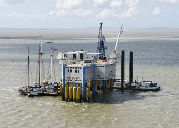
Fig 7. Production platform Zuidwal, prospecting for natural gas just next to the volcano, is one of the suspects to have caused instability in the underlying bedrock (image: blog.erwin713.nl
Another potential cause for unrest, both underground and above ground, is the mining for salt. In the province of Friesland you can find a salt industry that extracts salt from deep caverns under the Wadden Sea as well as in Delfzijl and Veendam in Groningen. They use vacuum salt technology: you pump water into the domes that lay deep in the underground and pump brine out. Near Harlingen, at around 10 km from the Sûdwalvulkaan, salt is extracted a a depth of around 2800 meters. The company and other parties involved try to sell it off as sustainable, because in the future gas, CO2 or oil can be stored inside the caverns caused by the salt extraction. The company recently received a permit from the Dutch authorities to extend their operation under the Wadden Sea to a larger area. The subsidence that will result, is a ‘calculated risk’, while critics who did their own calculations warn of a much larger subsidence than foreseen in the official reports.
Taken together, the effects of gas and salt extraction may well give similar effects as that of isostatic rebound, which is known to lead to an increase in volcanic activity. Whether or not the recent signs of unrest are true signs of the Zuidwalvulkaan reawakening or merely the effects of man’s exploitation of natural resources will have to await further study, Professor Eisinga concludes.

Fig. 8. Zuidwal Volcano, cross section and depth (Image credits: NITG – TNO; Source: NPO Wetenschap)
Further reading on the Zuidwal Volcano:
https://www.dinoloket.nl/zuidwal-volcanic-formation-xxzv
/Fopke Brandarius


Pingback: The North Sea and the Zuidwal volcano | VolcanoCafe