Welcome to our April-1 story which has the untruth, the whole untruth and nothing but the untruth. Nothing in here is real. Although even that is not true. The mentioned rocket propulsion methods all exist or are under development. Even the rocket railgun launcher, which we carefully made up for this post, suffered from a reality check when the Chinese company announced it while we were writing. The idea came from the VC brainstorm, the details and images were by Lughduniense and the text was by Albert. All of us deny all responsibility!
Mount Rainier to become spaceport
Mountain renamed Mount Bezos

A test launch of a conventional rocket from the Bezos sub-spaceport took place earlier today. (AI generated, of course..)
A top-secret development on Mount Rainier came out in the open this morning. There was widespread surprise and excitement when people in Tacoma and Seattle saw a rocket launched from the summit of the mountain. Shortly after, USGS announced that a new spaceport has been developed on the summit of Mount Rainier.
The development had been advocated by Amazon who is also the main operator of the spaceport. It has been funded entirely from private finance, shared between Amazon and the Ares Management Corporation.
The site is too far north for orbital launches (which need the extra push from the Earth’s rotation). However, it is perfect for suborbital trajectories. The announcement explains that it will become the world’s first sub-orbital spaceport.
Amazon will use the sub-spaceport for its revolutionary ultra-fast package delivery (UFPD) system. Launches from the site can deliver packages to any location in the US and even Hawaii within 20 minutes.
Amazon has named the ultrafast delivery service ‘Amazon SubPrime’, in recognition of the sub-orbital speed of delivery.
Mount Rainier
The mountain is uniquely suitable for this development. The summit altitude of 4 km greatly reduces the air drag during launch. The site is located less than 100 km from the Amazon headquarter campus in Seattle, and excellent road access is available because of the National Park. The Mowitch Lake road was paved during the winter closure.
As of today, Amazon has sole use of the Mowitch Lake road (SR 165). There is no longer access to Mowitch Lake or to the Wonderland trail from this road: all tourists are being redirected to the Paradise and Sunrise entrances on the south and east side to Mount Rainier. The summit area is wholly owned by the Amazon Ares Alliance, or AAA; access is restricted to Amazon SubPrime customers and suppliers.
The National Park has reverted to its original status of a National Forest, and now falls under the remit of the National Forest Service.
In recognition of the major investment made by Amazon in the development of Mount Rainier, the mountain has been renamed Mount Bezos.
The designs for the sub-spaceport are on display in the Amazon Spheres in Seattle, also proverbially known as the Bezos Balls. Booking is required: please call Amazon for a viewing slot.
Green rockets
The design for the sub-spaceport is revolutionary. For the first time, the rockets will be entirely electric.
(Originally, the plan was for hybrid rockets but new developments have made this step unnecessary. A demand by the American Coal Board to have the rocket powered by coal was rejected by Amazon.)
Rocket launches are limited by fuel. The need to carry the combustible fuel makes the rockets enormous. 95% or more of a rocket is taken up by the gigantic fuel tank. The bigger the rocket, the more fuel is needed to get it off the ground.
Various new developments are trying to solve this conundrum. The US company Green Launch is building a hybrid hydrogen impulse launcher, where the initial acceleration is provided by ultra-compressed hydrogen. This massively reduces the amount of fuel needed to be carried, and increases the payload from 1% to 10% of the mass of the rocket. It is not suitable for human flight because of the very high initial acceleration (20g) but this is not a problem for cargo.
Spinlaunch is doing something similar but using a giant catapult with even higher g-forces.
A Chinese company called Galactic Energy is developing an electromagnetic launcher using superconducting magnets. A similar system is also under development by the ALTA government department in Japan.

Experimental ALTA 40-m railgun (Japan) for hypersonic launches
All three systems are hybrids, where the electric engine provides a big initial boost, after which a traditional rocket system takes over to propel the satellite or cargo into space. It reduces the amount of rocket fuel but does not eliminate it.
If, however, the goal is not to get into orbit but to achieve sub-orbital flight, then the rocket fuel may be dispensed with. This is used in the Jeff B. Bezos sub-spaceport.
Railgun launches
The sub-spaceport will operate with exciting new technology. It uses an electromagnetic propulsion system, also known as a railgun, similar to that developed by Galactic Energy. This is the first commercial application of this technology.
The Amazon SubPrime package is enclosed in a winged metal container, and put on rails which carry a large electric current. The container is subjected to a strong magnetic field generated by superconducting magnets; the combination of the field and the current results in a force which rapidly accelerates the package. The system reaches speeds of 3 kilometers per second, sufficient for suborbital launches. Amazon has called the system VOLcano DElivery using Magnetic-driven Orbit-Rated Transport, or VOLDEMORTTM.

A VOLDEMORT launcher at the Jeff B. Bezos Sub-spaceport
Amazon packages can withstand accelerations of 300g, as has been proven in many deliveries: it is equivalent to the impact force on a heavy package being thrown over a fence.
The EM rail system will launch the packages an angle of 45 degrees for maximum reach. The wings are deployed during re-entry for steering. The on-board AI targets the exact GPS coordinates provided by the consumer, but can also aim for a nearby Amazon collection point if no suitable landing spot is available.

VOLDEMORTTM generates a lot of heat during launches. Cooling will be provided using the glaciers on Mount Bezos. The amount of ice on Mount Bezos is sufficient for 20 years of VOLDEMORTTM operation.
The VOLDEMORT system is described in a recent paper by I.R, McNab, Launch to subspace with an electromagnetic railgun. IEEE Transactions on Magnetics. 35 (1): 295–304. https://ieeexplore.ieee.org/document/1179826
Volcano designation
The fact that Mount Bezos is a listed volcano affected premiums for package delivery insurance. Amazon has appealed to USGS, and argued that no eruption has ever been observed, and that the indications for eruptions more than 2000 years ago lack eyewitness accounts and cannot be accepted as factual. USGS has accepted this appeal and therefore the mountain is no longer listed as a volcano, subject to a review in five years.
Some reluctance on the side of insurance companies to accept this decision was resolved when AAA bought a division from a lesser-known insurance company and rebranded it as Amazon SubPrime Insurance.
The five-year review of Mount Bezos as non-volcanic will involve evaluation of seismic monitoring data. Amazon argued that the US does not require monitoring of a mountain that isn’t a volcano but that argument was rejected by USGS. Because of the reclassification, seismic monitoring by the Cascades Volcano Observatory (CVO) ceased, as the mountain no longer falls under its remit.
AAA has contracted KVERT, the Russian Volcano Observatory for Kamchatka, to carry out remote monthly checks. They will also carry out the five-year review.
Power
The original plan was for VOLDEMORTTM to be powered entirely by the geothermal heat at the mountain. The reclassification of Mount Bezos as non-volcanic has reduced the amount of geothermal heat that may be extracted, as without volcanic activity this heat is no longer considered renewable.
The cooling of VOLDEMORTTM using the glaciers will lead to greatly increased run-off in the rivers, especially the Carbon River. This river will be used to supplement the energy requirement using hydropower.
In celebration of the opening of the unique, fully green Sub-spaceport, Amazon has renamed the Carbon River to Carbon-Free River.
Volcanocafe, 1 April 2025

The new SubPrime™ headquarters for the new ultra fast drone delivery service.
Postscript
Boeing has immediately announced that it has developed a similar launch system. It is called the Dreamlauncher Max, and is located on the remnants of Mount St Helens. Tests have so far not been successful
Other countries are known to have similar plans. China is building a sub-spaceport in Tibet, able to reach the entire Asian continent. Russia is doing the same, reaching all of Russia including Ukraine, Poland, the Baltic republics and Alaska, all of which the US has agreed to hand over to Russia in return for lifting all US sanctions.
Critics have dubbed these systems ‘WMDs’ or ‘Weapons of Mass Delivery’.
Postscript 2
Amazon has just announced that the forthcoming Amazon SubPrime subscription will also include movies played at double speed.
Amazon Subprime will not be available in Canada because of the re-entry tax.


Kudos on a *truly* timely ‘prank’.
Thank you, I needed a giggle…
And, Iceland geology has contributed pyros to party…
( Would new source of geo-thermal heat suit hydroponic cultivation of Spaghetti Trees ?? )
OT: What should we make of recent succession of ‘mild’ quakes forming a N/S alignment across Alaska between Anchorage and Prudhoe Bay coasts?
Seem too early to be ice-thaw events…
While Mt. Spurr awaits go-code…,
Katmai (Novarupta!!!) used the opportunity of 1st April to get into the volcanonews. Not with an eruption like 1912 … but with a “wind lahar” which has blown old ash through the region: https://www.volcanodiscovery.com/katmai/news/268212/vaac-advisory-2025-005.html
This reminds that sometimes a long time after an eruption, there can still happen a movement of old ash or aged lava by weather forces. It applies much to regions without much vegetation/trees, also parts of Iceland’s desert.
Yup,,,, had local people wonder if the ashyness of the sky was from Spurr… i figured it was from Katmai… it looked like a light grey fog up high in patches.
Maybe with an eruption at the exact moment of a launch, can give 100x the propulsion and enable the projectile the ability to penetration the firmament in the atmosphere which has never
been penetrated in the past.
I would have expected something more vigorous, if that’s all we could say that the series of Grindavik episodes is now at its definitive end.
Maybe as the construct the space port they will discover the alien UFO base already secretly located in Mount Rainier.
Zuckerberg phone home!
Likely connected to the one under Mount Shasta!
Ok, that’s new. I see no fountains on any webcam right now. It can’t be over that soon can it?
If so, this might actually be the shortest and smallest of all the Reykanes peninsula eruptions since 2021. Which would be unbelievably ironic considering this is probably the largest magma intrusion so far.
A true April Fools eruption!
A comment on Facebook suggests it’s the dyke intrusion just happened to reach the surface. The bulk of the intrusion is still down there, waiting for a real way out.
Some larger quakes now, 4,9 and 4,7, not fully checked yet, Reykjanesta.
Raspberrystation graph
The quakes are probably in Svartsengi’s system, but there are a lot of ghost quakes all around. Correct strength, but wrong digital location.
The quake activity on the peninsula still is very high, counting about 20 per 10 minutes. Indicating the dyke is propagating further.
Looking at the map with checked earthquakes, it seems it is still heading northeast.
Past 24hrs:
Inflation on Kilauea continues, so we still are in the “inflation eruption” period, which precedes the spectacular main eruption:
The eruption near Grindavik seems to be over, but it can be the first phase inside a longer eruption episode. Last hours there was a strong earthquake swarm with quakes > Magnitude 3, including two close to Magnitude 5. The swarm is strong enough to be felt by humans (and animals). A reporter of RUV says that she “she has not felt such strong earthquakes since the first eruptions.” It is possible that the main eruption will happen in the northern part of the fissure (safe location for Grindavik), where the dike is extending.
RUV reports about the strong earthquakes: “Jóhanna Malen Skúladóttir, a natural hazards specialist, says that the earthquakes are so-called trigger earthquakes, which are due to changes in stress due to the eruption in the Sundhnúkur crater series.”
An Image with Kilauea’s lava soup:
V2cam allows to watch both cones. The S cone is only steaming, but it can anytime change quickly:
https://www.youtube.com/watch?v=oG5zz9Sjw3E
The erupting N cone does a lava wave show. Sometimes you see big fountains and you wonder whether the volcano’s going to start the full eruption mode now or not.
Never thought that Kilauea viewing would be better than Iceland….but that could change soon.
Or if Kīlauea goes full Etna in a few hours. Even better is a more major Sundhnukur eruption AND tall fountain Kīlauea…
This is the correct link:
Thanks…I needed that!!
Btw this is a nice page to check your fav station, all pics are clickable to get the full sized graph.
“http://hraun.vedur.is/ja/drumplot/drumplot/index_2.0.html”
After a few hours out, I am so happy to see the eruption subsided near Grindavik. Quakes are overall larger though, so it is difficult to know what to expect next. The Reykjanesskaga quake just before 5 PM local time is expected to be stress relief and is reported to be at 5,3. (Both are info form RUV).
Phew. April 1. isn,t only a joke. Great post Albert! 🙂
That greenhouse is living a charmed life.
So the greenhouse effect can continue … 😉
the swarm is still cutting its way through the ground lateraly.. once it hits a hard spot it will go towards the surface
I’ll wait until the quakes are corrected, but this eruption coincided with some seemingly serious seismic events only to blurt out the equivalent of a wet fart. Was this the already in-cognito magma from previous dykes, pushed out by high pressure? I don’t see how this is any of the fresher stuff that’s swelled the magma chamber in recent months. Very little gas pressure in those fountains.
Worth noting that it began on or south of Hagafell and worked it’s way down though (and partially through the barrier). I do hope they have time to patch it up a bit before the (possible) main event.
Safety note.
Awning structures are quite handy and offer a place out of the sun to enjoy sipping coffee watching the storms drift by.
Mine knocked the ever loving shit out of me a couple of days ago.
CHECK your awning for structural flaws and blocked drainage. Mine nearly broken my neck.
I’m fine. ER said I’m good.
Bad luck, Geo. Swift recovery!
It seems to me that this eruption wasn’t fresh magma, but previously emplaced stuff that was pushed out by pressure from the growing dike. The dike itself is going elsewhere and may erupt (probably will but nothing is guaranteed) on the opposite end. Grindavik lives to fight another day: I hope and expect that it will be ok after this scare.
Would that be shown in the colour of this magma? It looks more silvery than previous issues.
That actually usually means its more primitive, or fresh… But its probably more related to the lighting angle than anything else. Its also gone the usual black colour after cooling.
For some reason too, pahoehoe in Iceland is usually less shiny than in Hawaii. Holuhraun had very similar composition to Kilauea but wasnt that shiny. Reykjanes is also very similar and same except for on active lava. Other Iceland volcanoes have less tholeiitic compositions which would seem to give a reason, except the very similar slightly alkaline basalt at Hualalai is also shiny…
My best guess is it is environmental somehow, maybe not in an obvious way either.
This was probably the reason, why the fissure close to Grindavik didn’t send lava flows to the village or the sea. The spattering there was with little volume.
Good photography here https://www.youtube.com/watch?v=18pWj0Ofs0E of the current eruption
Meanwhile, in New Mexico… https://www.facebook.com/photo?fbid=974630028171271&set=a.636832475284363
So Reykjanes never got vaccinated for quake measles.
Another geological riddle.
If it does erupt up there that would be a big change. Theres one single tiny vent from about 3000 years ago, otherwise nothing. But then the eruption last August was right at the northern limit of older fissures abd was very strong for over a week after the curtain of fire stage so maybe something is different this time.
It might be too late for a real lava flood opening, but an eruption up in the northern end of the dike could reach the ocean pretty easily with high flow rate. And in the process cut Keflavik off from Reykjavik and rerout everything back through Grindavik…
It is weird the Sundnukur dykes propagation pointing to northeast ends (?) in the area that was the expected to be the spot where the next Fagradalsfjell eruption near Keilir could have been taken place. The two fissures, Fagradal and Sundnukur have developing parallel to eachother. And parallel to other historic fissures. Untill now.
So a dyke can jump from one to another fissure. Maybe a bit premature. Bardarbunga did that to (going east and taking a northern pathway after that), to end in Holuhraun.
Well, faults there are almost merging north of Keilir, IMO’s map is showing. 😁
Jumping is a bit, erhm, not the right word. Flowing into… 😏
The map fom 18.30 frettir
https://en.vedur.is/about-imo/news/new-magma-instrusion-on-sundhnukur-crater-row
Its not that close to Keilir, there are non eruptive fissures from Sundhnjukur going up this far, and one small eruption in the area too. Keilir is a lot further east.
I think too Holuhraun wasnt really infiltrating other systems. Bardarbunga has erupted there way more times than anything else, maybe even the only volcano that erupts there… And the whole idea is based on the incorrect assumption old Holuhraun was an Askja eruption. And maybe that a temporary cluster of earthquakes outside the known volcanoes was something other than recharging of the biggest active caldera on the island. Its also a lesson that the fissure swarms dont really have bounaries more edge gradients.
The one example is Eldgja, where the end of the fissure erupted some lava that originally came from the other side, probably pushed out by the Eldgja magma. There can be some, albeit limited, overlap
Those systems are still in line though, unlike what was proposed at Holuhraun.
Im not so convinced the dike at Holuhraun actually started as a radial intrusion either, that part was pretty indistinct in all the quakes, while the dike going north was very clear. The part between the caldera abd the obvious dike was another kind of intrusion I think, or even pre-existing and just close to the dike origin. Kilauea showed that all tat is needed for an eruption of that size is a hydraulic connection, the eruptions in Leilabi Estates started from a dike that began just west of the highway, the rest of the pathway within the ERZ already existed.
The Sundhnukur and the Fagradalsfjall fissures are going to respect each other’s territory. But the broad shield volcano “Þráinsskjöldur” of Fagradalsfjall’s system is so big, that its lava flows extended into Svartsengi’s territory. There pre-historical fissures erupted on the slopes of Þráinsskjöldur’s shield.
South vent at Kīlauea is now high fountaining. Questions is how high and large this time round?
3 options
It goes bigger than last time
It goes longer than last time
It ends with net positive on magma, which has implications…
Im going with the first option though, its at the rim already and north vent is unchanged. I think we might see 400m+ this time and sustained too not just a burst.
I guess it might just stop too but the only people who think that are the ones who dont understand Kilauea isnt a normal volcano… this isnt stopping, blocking the vents did nothing, its only going to stop with an eruption at low altitude maybe decades away.
One odd thing I would like to note is that the north vent did not gas piston (maybe minorly at most) before this and even when the south vent is fountaining at the moment, the north vent remained mostly unchanged. So something is going on…
Maybe the vent was blocked enough that it isnt wide enough to drain back. It also didnt shoot up with the south vent either, like last time.
Going way above the rim now, all the time
Nice one Albert!
Yesterday was excellent, I was able to watch the live coverage of Elon launching four private astronauts over the poles. A very fine show!
Jeff Bezos and Blue Origin also has an X account that I keep an eye on; he has an update today.
He’s taken a leaf from SpaceX’s book and does live coverage shows too. The first launch of New Glenn was epic, even though the booster went kaboom on the landing attempt. I hope they will succeed with the next attempt!
Im not so sure we should expect an eruption up north, theres no evidence of any eruptions that far in the Holocene or any subglacial terrain. There are exceptions but it seems likely to stay underground. Maybe some does erupt, but unless the intrusion becomes long lived and open from the source it probably cant erupt that far away.
Kilauea though is going crazy, sustained fountains going far beyond the rim, probably at least 250-300 meters. Some bursts might be much higher. And the north vent is still overflowing as though nothing changed too, it hasnt shut down yet. Interesting…
Ummm. so what happens to the rest of us and life as we know it in the surrounding areas… When the rocket implodes or explodes? Does that mean a MASSIVE Volcanic Eruption??
Do they not realize that the Volcanic caldera of Mt Adams, Mt Baker and Mt Rainier is connected? That if one goes, all go? Or are they trying to extinct us here?
I’m very concerned and confused.
Alright, so at this point the dike is over 20km long! Earthquakes do seem to be declining a bit. I do wonder if this means like the first great dike the available volume gets used up underground.
It is also a good position for the emergency admins. An eruption there would be in the volcanic desert of iceland with no humans and infrastructure threatened. A good tourist eruption like Fagradalsfjall, but bigger.
No it would flow over the road between Keflavik and Reykjavik. Not a total disaster but it would be a big problem still. Although at this point I dont think it will erupt at least not enough to flow anywhere fast.
Past eruptions in this area didn’t reach the road or ocean according to the lava layers. I expect an eruption in Svartsengi’s north to be too short and small for this.
Only a very unlikely eruption of the shield volcano could bury the north coast. But that happened very early in Holocene and is part of Fagradalsfjall’s system. It was an extraordinary eruption. If Svartsengi finishes its series, I think it’s more likely that Fagradalsfjall continues to do eruptions like Litl Hrutur 2023.
Kilauea is incredible tonight.

Thank you for the still. Live feeds are good, but usually stuff is over by the time I get up, or it’s the next day anyway!
It has erupted for 11 hours now! From 10:20 a.m. to now 9:20 p.m. Hawaii Time. The lava fountain looked very stable during the whole day. No fluctuation unlike the previous episode. Episode 16 shifts to a more steady activity, maybe the future mode of Kilauea’s summit episodes?
I think its more a case that there was more magma available before, so it can go longer. The interval between eruptions and the intensity is the same but E15 stopped pretty early, so all the usual recovery started without emptying the pressure. Its particularly obvious on SDH as that station showed almost double the inflation as was lost in the last episode.
Earlier I said that with the pressure built up that E16 is going to either last longer or have record high fountains and eruption rate. Seems the longer option, although it has probably also broken the fountain height record too 🙂
I noticed the north vent stopped too, but that there is still enough tilt left that it could go on for at least another few hours. Although it might end soon if the recent upwards trend on SDH is kept. Still crazy to be going this long at such a high rate.
Episode 16 has already begun do die. The North vent has ended, and the lava fountain also looks to be slowly decreasing. I think it’s over during next hour. But the ~12 hours of sustained tall lava fountains (around 200m) is very impressive. We need to get a lava map of the summit afterwards.
Is Episode 16 more than the previous ones driven by magma pressure instead of gas pressure? A fluid magma pressure could explain the stable eruption mode, while a more gas driven eruption would probably be more instable and disruptive.
Episode 16 has decided to continue with a vital, massive lava fountain. How long can it live?
Actually this is the first episode with a slightly lower intensity than the previous ones, see the Uwekahuna tilt, and that’s why it’s lasting so long. Yet the fountain is higher, so likely faster ascent, which could be due to the north vent not erupting a meaningful amount of lava this time, so all the output gets focused into one vent. Maybe the dike was still molten until last episode, which gave high eruption rates relative to fountain heights, but now it has become two separate pipes, with only the south one producing high fountains. BTW, I think some diffuse spurts got to 400 meters tall, though HVO would probably not count them.
EpicLava has a picture of it shooting to over twice the height of the rim, with the top another 50% taller than that. So 160×3, which is 480 meters. I think its a little less but still well over 400 meters. Sustained height is less but still much taller than the rim so probably going at least 200 meters all the time.
There is also still SDH, which is recording the tilt change deeper than the shallow part of Halemaumau. That deeper storage is more pressurized than higher up and so its feeding the eruption too. The last two episodes were fed a bit more from the shallow storage compared to now. So I dont think the rate is necessarily lower, just that it has more area to draw from so pressure is released slower from a bigger source. I agree though that it looks like the north vent might be dying, but it still erupted first so its hard to say this yet.
It does seem like its getting slightly weaker though, so probably about to stop but thats going to be a full 16 hours of fountaining above the rim. Only a few weeks back going taller than the rim was an almost mythical event followed by extensive controversy… 🙂
https://www.facebook.com/share/p/1AWiJ3a5i9/
In SDH tiltmeter the deflation is also slower than in the early part of previous episodes, so I think it’s clear that maximum effusion rates have been lower. I also don’t think the north vent will necessarily die, just that they seem to be acting increasingly independent.There are even some indications the north vent is more mature, given the gas pistoning and sooner activation, but that something in its geometry doesn’t make it very efficient at turning output into tall fountains.
Back on day 1, the south vent of today was actually the northern of two massive fountain vents, the other one barely survived E2 and died, but was the dominant vent of the eruption start. Todays north vent was just a small fissure off to the side, the part that would be expected to die, but apparently it didnt. Still, it might be expected to go through the whole lifecycle faster if it was smaller to begin with.
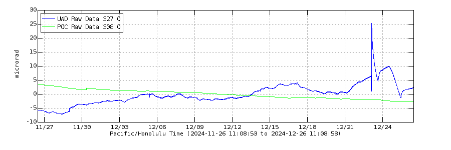
That does bring up implications why the south vent now is getting ever more active. Even if eruption rate is lower its not half the rate of before and has still been high fountaining for nearly a full 24 hours, its only 30 min away as I write this. 14 microradians of deflation on UWD, which is probably over 8 million m3 erupted. And the fountains over 200 meters for most of that time too, so it seems to be an eruption driven by gas pressure more than anything else.
I also noticed that UWD didnt recover fully, while SDH far overshot by nearly double. If it was all down to UWD and the shallow system it would have been small, so it looks like the deep system has a lot more say in this now. I wonder if the magma is more primitive now than before, or at least more volatile rich.
From Washington University:
“Could convection in the crust explain Venus’ many volcanoes?”
https://source.washu.edu/2025/03/could-convection-in-the-crust-explain-venussmany-volcanoes/
which refers to an earlier article:
“Scientists share ‘comprehensive’ map of volcanoes on Venus — all 85,000 of them”:
https://source.washu.edu/2023/03/scientists-share-comprehensive-map-of-volcanoes-on-venus-all-85000-of-them/
So, apparently Venus beats Earth in this respect?
To be fair it doesnt recycle the crust the way Earth does, or erosion. Most of the volcanoes are probably extremely old and very dead, but not all of them.
There are about 2000 active volcanoes and if the average life is a million years, then in a billion years there are 2 million volcanoes. Venus surface probably isnt nearly that old but still 85000 might only be a few tens of millions of years of volcanoes on Earth. Maybe Venusian volcanoes get an average lifespan much longer than ours, without plates moving them. But then to have only 85000 in a billion years would mean they might need to live 11 million years on average. This is all very rough but it would surprise me if Earth hasnt had at least as many volcanoes as Venus, given it is both bigger and probably a bit hotter inside, and has more ways of actually creating them.
Woud a Super Earth ( those can be quite alot larger than Earth and should have a much hotter interior because of that ) coud souch a planet still produce komatites today at same age as Earth is today?
Interesting map. 85,000 volcanoes includes monogenetic volcanoes like shields and pancake volcanoes, though. The number of polygenetic volcanoes is probably around 1000-2000 volcanoes, and the vast majority of them have former summit areas that are now depressed into the land as seen in Magellan data, so have sunk into the planet and are no longer active. I doubt the number of active ones is much more than 10 (notably Maat Mons, Ozza Mons, Theia Mons, Tepev Mons, plus a bunch of others that are not yet sunken down). Venusian volcanoes are far bigger and more powerful than terrestrial ones, however, and have vast networks of dikes and sills reaching up to hundreds of kms outwards from their summits.
And a Super Earth may have had hyperactive tectonics you haves a thinner litopshere and an astenopshere thats hotter than either Earth or Venus. Venus litopshere seems rather hot and little like puddy deformable maybe this is caused by the very high atmopshere temperatures? Venus is only going to get hotter too on the outside due to more co2 accumulating and the sun is getting brigther as times goes by. Venus outside likley will melt completely in the comming few 100 s of million years due to the increasing solar luminosity and it will retain its heavy atmopshere well until the red giant stage
Venus only needs to become 800 c hotter for its exterior to simply melt completely into a global magma ocean. Venus will also likley retain its thick carbon atmosphere well well into the future so it seems like a very realisitic scenario under a brigther and brigther sun, you needs that thick dense atmopshere for the nightside to be molten as well.
Personally I think its probable that venus, too, has had a massive planetary impact. This easily explains its retrograde rotation and a rather active core and atmosphere.
Venus is togther with Earth the two larger rocky planets in this solar system so thats why these two have the most geological activity these two have the most trapped radioactive elements and trapped ackretion energy inside of them. ..
I can just imagine how strong the internal heat must be inside a Super Earth of 10 Earth masses or more. Souch massive rocky worlds will perhaps struggle for a long time to leave an early archean like geological state due to the crazy geothermal flux. I hopes for warp space travel so we can do a geological expedition to an alien Super Earth! I Imagines.. seething landscapes full of geothermal pools and smoking volcanoes! the immense heat trapped within numerous earth masses and more… 🙂
Well, if they say so – it is a rather new thought. Venus was thought to be inactive, but there are new clues, obviously. If yes it would probably be a slow process – no water, at least not subaerial.
“Venus — a hot planet pocked with tens of thousands of volcanoes — may be even more geologically active near its surface than previously thought. New calculations by researchers at Washington University in St. Louis suggest that the planet’s outer crust may be constantly churning, an unexpected phenomenon called convection that could help explain many of the volcanoes and other features of the Venusian landscape.
Solomatov
“Nobody had really considered the possibility of convection in the crust of Venus before,” from piece
https://www.sciencedirect.com/science/article/abs/pii/S0031920125000263?fr=RR-2&ref=pdf_download&rr=91f5487c2a6bdf21
“On the possibility of convection in the Venusian crust”
corr.: thought not to be completely inactive but in a process of exchanging all the crust in one blow every ~600.000 years
Eruptions that happened in the 1990 s lava surface changes have been confirmed in recent re – analysis in the Magellan imagery. Venus is almost as large as the Earth so its quite hot inside and haves a rather large heat stoorage. Due to the lack of tectonics venting heat its possible that Venus astenosphere is even sligthly hotter than Earths even.. even if Earths center maybe sligthly hotter still
This Svartsengi webcam shows the potential area of the eruption along the northern fissure. The slopes of the shield volcano “Þráinsskjöldur” are visible as the horizon on the right half of the view. It resembles on small scale the slopes of Mauna Loa:
GPS: SENG station did a strong move to N (3cm), W (17cm) and some deflation. What does this N and W movement mean?
It’s a superposition of deformation from sill deflation and dyke intrusion. Dyke intrusion will cause NW movement and deflation will cause a SW movement for Svartsengi. The result is dominated by the western movement, since that gets a contribution from both sources.
The most interesting station in my view is Austurvegur (AUSV). It’s located on the eastern side of the November 2023 dyke, but the motion is towards NW. This tells us that the deformation is dominated by the deflation, otherwise it would have been pushed SE. Looking a bit further east, we have station Sudurstrandavegur (SUDV). This one did move towards SE. That tells us that the dyke intruded towards the south, but did not extend beyond the eruption site, since that would have pushed AUSV towards SE. The quakes SW of Grindavik are trigger quakes and not a further extension of the dyke towards the south. At the moment, magma migration is focused towards the north. A new eruption can happen anywhere along the length of the dyke, but I have a hunch that somewhere around 63.941, -22.279 is currently the best bet.
According to the “map layers” with prehistorical lavas this is the most extreme northern possibility for a Svartsengi fissure. There an eruption would be small, probably like the one near Grindavik yesterday.
More volume was prehistorically released NW of the Fagradalsfjall plateau.
That looks a good bet or over the cluster of quakes just to the northeast. If that happens, I would expect the lava to flow north or Northwest. I think Vogar is on a small hill, so would be safe but could get surrounded, depending on the size of the eruption. That would be the easiest spot for Chad’s sea entry.
The activity is dying down slowly, so it may just be an intrusion this time (that will obviously be the trigger for the opposite :P).
IMO states “Over time, the likelihood of a new eruptive opening forming along the dike is decreasing, though it cannot be ruled out due to ongoing microseismicity in the area.”
So the longer no eruption begins on the northern dike, the more likely the episode is over … and I imagine that in this case it has been the last episode of this eruption.
During the Medieval Fires, the Fires on one system usually lasted for 30 years. So it looks possible that over next 30 years eruptions come back to Svartsengi, but it is difficult to predict. 900 AD, when the Fires began, there was a “lonely” lava eruption at Afstapharhaun (Krysuvik). This means a lonely eruption in one is possible. We have to wait and watch whether Svartsengi gets eruptions again or other systems do something.
However I think that the magma source at Fagradalsfjall is alive. If magma doesn’t go to Svartsengi anymore, it will find alternative ways and destinations.
I think it’s too early to say it’s the last episode. We should get some clues over the next week or so though.
Have they already forgotten about the run-up to the first eruptions, when the quakes more or less stopped a few days before the eruption started?
As a species, humans are very good at forgetting.
Krysuvik station has moved S and E, it is probably predominantly the impact of the dike formation:
http://brunnur.vedur.is/gps/eldfjoll/reykjanes/KRIV-plate-90d.
png
Keilir station has also moved S, E and up
NAMC (western Reykjanes system south of Keflavik) went N, E and a bit up.
That was quite a day, with an explosive breaking news, a long-awaited eruption in Iceland that wasn’t it, and a quick attention grabber from Kilauea. This (April 2) is the time of the year when volcano observatories ask us to put a disclaimer on the April-1 story since otherwise they get called up about it months later. So hereby, an acknowledgement and apology that our breaking news wasn’t quite true. April fool stories have gone out of popularity in the past decade, presumably because of the uncertainty in the US about what constitutes a ‘fact’. VC remains fully wedded to scientific facts. Except on April 1 when we try to uphold the ancient tradition. We hope you enjoyed it.
The following has been added to the story:
Welcome to April-1 story which has the untruth, the whole untruth and nothing but the untruth. Nothing in here is real. Although even that is not true. The mentioned rocket propulsion methods all exist or are under development. Even the rocket railgun launcher, which we carefully made up for this post, suffered from a reality check when the Chinese company announced it while we were writing. The idea came from the VC brainstorm, the details and images were by Lughduniense and the text was by Albert. All of us deny all responsibility!
Quote> presumably because of the uncertainty in the US about what constitutes a ‘fact’.
I would rate this as anti-American as in Europe and GB there is a strange mixture of info and desinformation as well. It is not so funny to reach out at the US when Presidents change.
https://en.wikipedia.org/wiki/Alternative_facts
(Gorillas)
Dear Denaliwatch,
Don’t forget, there’s also a lot of joking by Americans about Europe and GB. Both sides, I think we like it, it’s a game, lol !!
But really, we have our “Western” culture, our basic principles, in common. (Yep, even though some of it is pure hypocrisy.)
Personally, I believe our recent fantasy, antifact sub-culture (both Europe and USA) has been a result of the Kremlin’s, and foolish oligarchs’, cunning geopolitical chess games and psyops. Social media has been their perfect tool.
First, some idiot politicians were leveraged to estrange GB from the EU, (Brexit disinformation) and now the same between the USA and GB + EU. I don’t know how we combat this.
I fear that, “divided, we fall”.
Reality rewards those who seek to understand reality and to work with reality. The laws which rule the world, can’t be changed … unlike the laws of state. If someone tries to work contrarily to reality’s laws, he will get bad consequences.
So those who trust in paranoid theories, have a big disadvantage to those who trust in science. A successfull society needs a minimum of freedom and creativity of their humans. If you reduce the freedoms and abilities to think, this will lead to increasingly failures. This is a point which supports liberal theory.
But scientists are at a disadvantage. They deal in uncertainty, and that doesn’t work against people who just make it up. It leaves science vulnerable.
Science deals with uncertainty, but usually there is an amount of broadly accepted sicentific facts, that usually are tought in first university semesters. Societies that respect scientific facts have an advantage compared to those who ignore scientific facts.
This currently applies to economic science. Although there are different schools with different opinions, there is still some kind of consensus on some topics.
Sure. But that is not what we are up against. People deny basic science, but refuse to go into scientific discussions. Instead they use soundbites. People are much more open to simple soundbites, or even simple tunes: it bypasses the brain. We are trying to have science discussions with people who deal in manipulation. That doesn’t work. Don’t engage: the only way out is laughing at them. But that will get you abused: insults are the last resort of people who have lost the arguments.
I enjoy to read the comments by economist Paul Krugman about the current trade politics. There you see a huge gap between facts and passion driven theories.
The current development is a nightmare for philosophers of Enlightment period. They tried to educate people and let them get out of their immaturity. But obviously the educators failed. Real education is like sports training. It is stressful. You have to get over this painful way, before the fruits can be earned.
Authoritarian tendencies favor job education over general humanist education. By this you have people who are good and useful at work, but don’t know much about the world around.
As a non-scientist, it seems to me that the key point is about truth-telling – truth-telling in a way that is commensurable with the matter in hand. Scientific method offers a very good way of truth-telling in its field, but like other forms, it’s open to exploitation by the unscrupulous. (And also by those who want us to think that science deals in certainties.) My spouse shows me I am loved by telling me truths I need to hear but would prefer not to.
In the political arena, truth-telling is much more fraught and falls somewhere between science and love in the nature of the realities it deals with and the risk of various forms of corruption to which it is open, which is why a robust, independent media landscape is vital. But in the end, mind-independent reality will outrun the wiliest scientific, political or amorous fox, “Events, dear boy. Events.”
Anyway, back to mind-independent volcanoes.
Haha indeed this is Elon Musks and Sheev Palpatines secret lair…I can almost see these two figures the cloaked clothed Palpy and Musky clad in buisness suit walking in these secret underground tunnels inside Rainer, having secret conversations on how to takeover the solar system. Grey, deformed and nearly decomposed by his great age Palpatine mentions to musk as they walk the secret tunnels ”you been very well trained indeed my apprenticse the fool that is Jeff Bezos will be no match for you… ” and Palpy laughs so the tunnels inside the mountain echoes….
Are they going to fly to Venus (Mustafar) or Mars (Tatooine without Oxygen)?
Hähähähähä hahahaha huhuhuhughhugh kvefff!!! ( Palpatines usual response ) the foool that is Bezos is no match for full power of the dark side… Elon been well trained indeed under Palpys teachings
Sice 6AM this morning (Icelandic time), most quakes are in the northern end of the dyke, but are smaller. The lava seems to still be hammering the rocks to find a path to the surface.
Very deep deflation, more than Episode 14 and 15; if it doesn’t stop, it will deflate more than the major Episode 13:
The view from the east side of the down-dropped block shows that the lava flows have reached the eastern border of the lava field, but that the west part of the shield has clearly risen by the accumulation of many short lava flows.
Apparently 90% of the magma stored since the last eruption has been drained, but theres still 10% left and the dike isnt getting longer. So no big eruption now but it is entirely possible still. Long dikes like this might stay open better than a purely vertical one with eruptions along ut to relieve pressure, so magma could just slowly flow into it for a while and erupt, like at Fagradalsfjall. Although I would say its a week tops still, if it isnt erupting by then it wont erupt at all up north.
What woud Bardarbunga do if all Icelands magma productivity vent into there under rest of my lifetime? thats of course an impossible scenario due to the local and regional geology but its fun to play around with stuff perhaps woud just become a halemaumau copy?
Also maybe to consider the area at Eldey and Stampar for the next eruption. Sundhnjukur was seismically active in the Fadradalsfjall eruptions, and it erupted next. But so were Kleifarvatn and especially out near Eldey going just onshore. Krysuvik has been picked as the next spot but I think it will go west is my guess. Which is a problem, as a few years of ashy submarine or mixed eruptions would be a real problem being so close to Keflavik.
I still feel like its too early to say Svartsengi is done though. It might well have slowed input because of magma pressure not low supply, it had enormous supply after the first intrusion. Now we have another huge intrusion draining it all out, so supply might well increase again. There is a limit of course but calling this over seems very premature yet I think. The increased northward extent of the rift might have saved Grindavik and Svartsengi though endangered the highway.
I agree with thinking that it’s too early to call Svartsengi finished, but the next week or two should give us some clues.
The magma supply below Fagradalsfjall’s system continued and was diverted to Svartsengi in November 2023. As long as this supply continues, we’ll get magmatic activity somewhere, either as intrusions or as eruptions. If the first eruption of Svartsengi ends soon with the last episode, Fagradalsfjall or Krysuvik might be next stations for an eruption.
2021-2023 Fagradalsfjall had a dormant time of ~11 months between eruptions. But November 2023 (Svartsengi) happened only three months after Fagradalsfjall III (August 2023). Did the magma inflow increase 2023, so that more activity in short time was possible?
I dont know if it was higher, the eruption rate in 2021 was about the same as the refill rate between eruptions since November 2023. Between 2021 and 2023 magma supply went between the two volcanoes at times.
In general though it seems likely supply of magma has increased since it all began in 2020. Other volcanoes are waking up too, so there is a huge volume of magma moving under Reykjanes. Probably a lot more than under Vatnajokull to be honest at least near enough to the surface to be an eruption risk.
2021 was in my opinion an above-average eruption, because it released a lot of magmatic (and gas) pressure accumulated in the years before. When the bottle of the volano was opened, the following two eruptions were the average type of Fagradalsfjall’s eruptions.
2023 Litl Hrutur (F III) had 15,5 Million m³
Of Svarstengi’s 8 episodes five had a volume of double to four times Litl Hrutur. Only the minor first and third episode were comparable to Litl Hrutur. The whole episodic eruption until now has erupted around 15 times of Litl Hrutur’s volume. So this eruption has exceeded the average Fagradalsfjall eruption a lot.
If this magma supply continues, but choses an alternative location, the next eruption will again be as voluminous as Svartsengi, but maybe different pattern.
Wasn’t it thought that when this sequence of events started, the magma was accumulating just inland of Reykjanesta, beneath Sýrfell? So might it be more that several systems’ supplies are being re-charged at the same time than that a single supply has been diverted? (And then there were strange events at Kleifaravatn ca. 20 years ago that may be related.)
Kilauea now at over 24 hours of continuous fountaining, most of that over 200 meters, and probably at times reaching 400 meters or more. Its pretty low now so reaching 25 hours might be uncertain but still what a day. It probably means there wont be an eruption next week though unless supply really goes crazy, my guess is 10 days recovery, so eruption on the weekend after this one coming, April 11-12.
In saying that, going by SDH tilt, there still might be a nother 3-4 hours it could keep going at the current rate. Its not my guess but who knows 🙂
There was also 1cm of tephra over the highway past the caldera, not exactly clear where but still that is at least 4km from the vent and probably a lot more going downwind. There is a new layer of tephra added to the surface of Kilauea, future maps will look very different to the tan brown we have come to recognise.
HVO update. Fountains from the south vent sustained heights of 600-700 feet (180-210 meters) for over 23 hours, then dropped to less than 300 feet (90 meters) at 9:50 a.m.
So close to a full day of fountaining over the rim. The majority of the lava must sink through the crust into the lava under the crater, it doesnt flow very far from the vents quickly anymore despite huge flow rates visible at the vent itself.
Theres also over 1.5 meters thick of tephra on the caldera rim now. And much much thicker between the vent and the wall, tens of meters. If it wasnt at the bottom of a cliff there would be a cincer cone probably 80 meters tall there now. If it reaches the height of the rim then it will be as tall as Pu’u O’o was at its peak in 1986, over 250 meters.
Its also now erupted probably at least 80 million m3 of lava, and maybe another 1-2 million m3 of tephra, which makes this a VEI 2 although I havent seen an actual number on that and it probably wont be mentioned because hawaiian type volcanism is always a VEI 0 by default… Its been erupting now for about 4 months, at this rate we are looking at 240 million m3 by the end of the year, which is more than the volume as what was in the lake before. And enough to fill the 2018 caldera in 3 years time.
This traffic sign is even buried by ~2 meter of tephra:
https://www.usgs.gov/observatories/hvo/news/photo-video-chronology-april-2-2025-kilauea-summit-views-after-episode-16
One vent (difficult to determine which, but I guess the N vent) is still/again glowing during the night. It looks like a mixture of Fumarole and Strombolian Spattering:
https://www.youtube.com/watch?v=oG5zz9Sjw3E
Maybe the eruption slowly shifts towards a permanent eruption at a minimum level. Episode 16 showed in general a continuous and steady behaviour. After the first 15 Episodes released a lot of gas, we appear to come to the main magma eruption that’s only determined by the recharge speed of magma in the summit system.
If its consistent with the S2 cam then its the south vent that is glowing. Its different to last pause, the vents stayed open. The S2 24h gif does show the front of the cone flowing away from the south vent though, its not completely solid but kind of behaves like a lava dome flowing. At least it does for a few days. This might bury the vent again but its stayed open so far.
I agree at some point the eruption will become continuous but its unclear what might cause that transition. For Mauna Ulu it became too wide and the conduit failed towards the east spawning several vents close to or in Alae crater which was already full by then. Pu’u O’o failed by getting too tall but it actually had numerous other lateral intrusions in its fountaining era before it failed fully in 1986. Both became continuous by forming flank vents further down the ERZ somewhat.
By analogy there are two ways this might happen niw. The first is that the lava fill gets so high it becomes possible for the molten interior to directly connect to the vent. The other is that magma pushes into the SWRZ from the south vent, and leaks out of the crack from 1823/1919/1971. This seems more likely but the vent might have to be almost as high as the rim to do this, so a while yet.
In any case maybe the most likely is just that the vent gets too wide and is able to convect and make a true lava lake. But it still might take a long time and a lot more episodes to do this.
Daylight shows that the eruption area is very strongly degassing and steaming:
https://www.youtube.com/watch?v=oG5zz9Sjw3E
Even on Mauna Loa you can see the strong gas plume of Kilauea. This means that gasses can escape freely between the episodes. Before Episode 16 gas was dissolved in magma and caused more violent and instable behaviour. Degassed magma can rise more calm towards an eruption and do steady/stable eruptions. The lava fountains of Episode 16 were not as spectacular and not as extremely high as the peaks of Episode 15, but they lasted incredibly much longer.
E16 had taller fountains, theres a probably 450+ meter burst on photo by EpicLava, its about triple the rim height and viewed from the north which acctually makes the rim look lower from perspective. HVO themselves have a similar image of a burst towering above the rim. Each episode has been getting bigger fountains. We will see for E17 if degassing has any affect, the degassing will only be in the vent conduit which is a small volume of the total, it also might not be the vents themselves degassing but the actual cone, the lava it is made of. Or it is related to humidity and the weather, if it is cold there now.
And
https://www.facebook.com/share/p/1AWiJ3a5i9/
Hey everyone, long time lurker here and fellow volcano aficionado!
I live on Kauai – the northwestern-most main island here in Hawaii – and my wife has given me the go-ahead to do a strike mission to go and watch Kilauea erupt – I missed this current one due to other commitments, but I am geared up for the next one!
Fingers crossed Pele has another huge fountain episode left in the tank for me!
What are your guys best guesses on the next recharge phase – the fountaining has just stopped at around noon HST, so 25 hours of high fountains.
A week to ten days?
My plan is to wait for the episode to start, jump on the next flight to Hilo and could probably be at the National Park within four or five hours of leaving my door…
I’d love to stay up there all night too if possible!!
I guessed 10 days, but it will take a few days to get an idea of recovery rate. But 10 days is at the same inflation rate as earlier gaps.
One thing though, if there is no glow ir degassing in the gap, I think that might indicate a longer gap with a larger episode. But we need more than one sample for a trend 🙂
Basically wait until the tilt is close to the peak of last episode then stay there for a few days.
Halemaumau now, no eruption but lava is now leaking out of the whole eastern edge of the lava lake. I think that big lava pond that the vents feed into must drain into the lava lake under the crust, to get this kind of reaction. It also drains following the episodes end.
So the 2018 caldera is filling like a liquid, but the area near the vents is building as an actual lava shield structure. Its going to be interesting to watch this evolve.
OUTL GPS station shows flat deflation since a peak around New Year’s Eve:
So the start of the SWRZ is losing pressure then. While the main chamber under the caldera is filling up. Although it is almost entirely erupting now instead of filling underground.
Seems even more reason to think this will be a long lived eruption, both rifts are dead silent and show no activity indicating magma moving, a far cry from only a year ago. This is despite the vents now probably getting to over 1000 meters elevation.
We really might be in for a new period of summit overflows before 2030 at this rate, I still hold my bet 🙂
The summit GPS looks more or less even since January:
The gas and steam emissions on the summit looks very violent now, it nearly looks like an eruption in itself. They are more than normal Fumaroles, but a real cloud and plume (visible from Mauna Loa). This continuing gas and steam eruption shows, that we’re in the midst of a violent eruption that sometimes is hydrothermal-gassy and sometimes magmatic. A gas and steam eruption like this would be a significant event in Yellowstone or Campi Flegrei.
I think these vents needs a new name, they are quite a ways, close to half a kilometer, from the former edge of Halemaumau crater.
I would agree but Halemaumau is still the name given to the 2018 caldera, so the vents are still in it. There might be a better case to give the new vents a name instead, particularly as this spot is likely to evolve into a new center of Kilauea regardless of the path taken. Be that a shield if it overflows, or a small pit crater if it returns to the rifts.
Last there in 2003. Three nights at Volcano House. It’s been an interesting quarter century to have borne witness to. . I videotaped my walkout to the Overlook Fence, now of blessed memory. along with all the ground I walked on that October, to thank Pele for her hospitality.
https://earth.google.com/web/@-1.60687491,29.24659808,1768.35145996a,842.33412978d,35y,-78.10010352h,2.88919406t,360r/data=ChYqEAgBEgoyMDIzLTA3LTE3GAFCAggBQgIIAEoNCP___________wEQAA
Nyiragonos 2021 flows are now zoned for urban developments there is no hazard risk tought at all here, every year the city is creeping closer to this volcano which kind of sucks for them, they know the next lava flood maybe only a decade away or so
Strange days. Now Krisuvik says hello:
Wow, the whole area got shook up by this intrusion. Its almost like a whole new rifting event was just started but in the same place as an existing one just further inland…
Inflation has already become clear on the GPS too. It will take a few days more to see a real trend but it might be faster than before too. The northern preference seems to indicate Grindavik could be saved but if it is a trend that intrusions prefer to happen inland it sets a dangerous precedent for Krysuvik rifting towards Reykjavik. Krysuvik is the same lava floods as Sundhnjukur but generally larger, sometimes it seems MUCH larger. Like reaching both coastlines with a single lava flow and 20 km long curtain of fire…
Looking at the seismograph, seems like volcano tectonic quakes or am I wrong? Looks a lot like tremor. (Not a geologist)
Following the path of the quakes is following the plate boundaries up to the northern part of the old dyke and then following it to the east towards Krýsuvik. As already stated a couple of times, this is just the beginning.
IMO has posted an InSAR image in their latest update.
https://vedur.is/um-vi/frettir/kvikuhlaup-hafid-a-sundhnuksgigarodinni
A very obvious dyke towards the north, complete with a graben centered almost exactly on the spot I suggested earlier. I had the E-W coordinate nailed down, but missed N-S by roughly 1km. Seems like I marked the edge of the graben rather than the center, but maybe that’s where an eruption is likely anyway, since it’s already fractured there. IMO says that the deformation suggests that magma is at a depth of 1.5km.
Around Grindavik the interferogram is a bit messy. The Svartsengi subsidence is very obvious, but then there seems to be a few faults east and south of Thorbjörn that disrupt the fringes. Maybe not unexpected, since that area is affected both by the deformation from Svartsengi and from the dyke.
The update is also available in English:
https://en.vedur.is/about-imo/news/new-magma-instrusion-on-sundhnukur-crater-row
When I was looking yesterday at that and the dog leg in the dyke, I was thinking it was close to where you said. I think it is also the location IMO suggested was an area it was close to breaking through.
Insar Reykjanes:
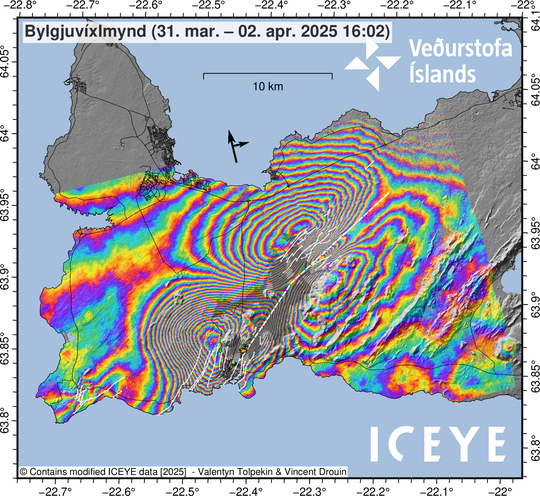
IMO’s analysis: “Deformation measurements show that the northernmost part of the dike lies in an area just under 4 km north of Keilir. Satellite imagery and modeling indicate that the magma intrusion came closest to the surface about 5 km northeast of Stóra-Skógfell, where its uppermost section lies at a depth of around 1.5 km.
Satellite images also show fault movements above the northern section of the dike, in the area northeast of Litla-Skógfell, where a new graben (subsidence valley) has formed.”
https://en.vedur.is/about-imo/news/new-magma-instrusion-on-sundhnukur-crater-row
I see there’s been a 6.9 and aftershocks on the Mid-Atlantic Reykjanes Ridge. At a dog-leg the other end of the Iceland events.
All this movement, it’s exciting!
https://earthquake.usgs.gov/earthquakes/map/?currentFeatureId=us6000q3nw&extent=-44.08759,-215.15625&extent=84.9901,234.84375&range=search&timeZone=utc&search=%7B%22name%22:%22Search%20Results%22,%22params%22:%7B%22endtime%22:%222025-04-24T14:09:29.757Z%22,%22latitude%22:52.4601,%22longitude%22:-32.1106,%22maxradiuskm%22:250,%22minmagnitude%22:3,%22starttime%22:%222025-03-13T14:09:29.757Z%22%7D%7D
HVO volcano watch about Kilaueas eruption. They are comparing it to Mauna Ulu and Pu’u O’o.
https://www.usgs.gov/observatories/hvo/news/volcano-watch-kilaueas-continuing-summit-eruption
I am holding to my prediction that lava will be flowing down the slopes of Kilauea again in 2030. At current rates of eruption and vent stability it will take only 4 years to erupt 1 km3 of lava which will probably build the vents above the rim of the caldera and overflow the 2018 collapse on all edges. If its like after 1790 it could keep this high supply for decades. It would be crazy to mark the 2018 1 decade anniversary by its massive collapse being overflowed like it never happened…
Can we really compare the eruptions on ERZ (Mauna Ulu, Pu’u O’o) with the current one on the summit or Kilauea Iki? Was the formation of the dike/dyke that feeds the current eruption or Kilauea Iki, comparable to the dikes to Mauna Ulu and Pu’u O’o?
I know that the Pu’u O’o eruption was preceded by a fast intrusion that moved the whole distance from the summit to there. Only the 1840 intrusion was faster.
Thats exactly what HVO are doing, comparing the eruptions…
The intrusion was pretty small, and stayed within the faults of the caldera. So maybe more like 1959 but really its more like the other post 2018 intrusions.
Pu’u O’o also started from Napau and Makaopuhi, same as the eruption in September last year. The magma system uprift if there already existed. So no there wasnt an intrusion that whole way. 1840 might have been as big as it looked though, an intrusion from the ERZ connector all the way to near Leilani Estates. But no dike on the ERZ has started in the caldera. HVO called the quakes flaring up on the ERZ connector ‘inflationary intrusions’ back then. But there are no dikes forming in that activity.
Mauna Ulu and Pu’u O’o later shifted towards a shield-building eruption with long lava tubes and relatively calm effusive activity at the central cone.
Kilauea Iki remained through its short time purely episodic without a shield-building stage (but a LERZ eruption followed afterwards). The eruption was (36 days) much shorter than our episodic eruption. Until now we haven’t seen a shield-building eruption in the summit caldera during colonial-historical times. Is our eruption going towards a shield-building stage or towards a rift zone eruption?
I really think that making predictions about Kilauea’s activity is a fool’s errand–too many variables.
I’ll be the first to admit that throwing one’s hands up and crying ‘black swan! black swan!’ is intellectually lazy, but Tutu Pele throws so many different things at us that all I can do is react!
Well you need to make a prediction to get wrong so we will see, its only a few years away 🙂
GVP reports two new activities (outside the volcanoes discussed here):
1. Shinmoedake (Kirishimayama, Japan) a short volcanic crisis/unrest with “A volcanic tremor signal was detected at 0256 and lasted 10 minutes.” The crisis was over afterwards
2. Poas (Costa Rica) increasing phreatomagmatic activity. ” At 0052 on 31 March a high-energy eruptive event ejected incandescent blocks and material more than 600 m high and generated a gas-and-ash plume that drifted SW and W. … The Alert Level remained at 3 (the second highest level on a four-level scale)”
I had a look at the Reykjanes GPS stations and, even though seismicity is subsiding, there are still a lot of things in motion. Most notably, stations around the northern part of the dyke are still moving away from the dyke. Vogar, Keilir and Fagridalur are still separating. I think an eruption is still highly likely.
The graben and horst movement by the dyke confuses easily with other types of deformation at the moment. That’s why it is a bit uncertain what IMO wrote here: “GPS measurements indicate that uplift may have resumed in Svartsengi, as shown in the accompanying figure. The most likely cause is continued magma accumulation beneath Svartsengi,”
The uplift at Svartsengi GPS station or Keilir station show the horst movement, that also was visible in the Insar image (Butterfly Effect). The horst has a very big area.
There seems also to be some vertical movement in the stations over the chamber and IMO have confirmed that the chamber is indicating signs of refilling. There are also some smaller lateral movements in the local stations. This is likely to be affecting the stations further away too. Some of it may also be from the dike and magma movement.
https://en.vedur.is/about-imo/news/new-magma-instrusion-on-sundhnukur-crater-row
Its earpy still, but Im going to go and say this is one hell of a ‘sign of refilling’…
Nothing is certain but it looks like these eruptive episodes end by eventually not having the supply to overcome magma pressure and erupt, not by actually losing supply rate unless it diverts somewhere else (we need to see that for the other volcanoes but its very likely I think).
Maybe it was ending before, and an eruption would have been the final. But because the magma all went laterally it fully decompressed the system again.
Basically, its just had another rifting event within an existing one, and reset back to huge supply. It is to the north so Grindavik might be saved but I dont think the eruptions are about to end, at this rate the next one will be in less than 2 months. I think the magma storage has grown over time, getting close to the size it was before the first dike, so refills arent necessarily further apart because of supply rate anyway. In which case what we see now is maybe the highest supply its ever been in this eruption series…
One thing that seems to be a trend is that eruptions in Grindavik are small to nonexistant, its not clear why but its happened twice now, apparently its easier to break 10 km of new rift than erupt in the area south of Hagafell. Grindavik would have been destroyed in the eruption end of May last year though if the walls werent built, so a worthy effort.
Actually, make that about 1 month or less if the upward trajectory stays. I think it was definitely magma pressure increasing that was slowing the supply rate as it appeared.
You have to distinguish between inflation by the horst movement and by actual magma filling. Added to this the horizontal tectonic movement in the area by the dyke graben can cause local tectonic stress and possible vertical movement.
The Insar map above shows clearly, where the horst is at the moment. The horst inflation includes parts of Krysuvik, Fagradalsfjall and western Reykjanes volcanic systems.
We have to wait, until the graben formation is completed, to use deformation as an indicator for magma inflow.
That isnt going to be a factor where the GPS is, they arent in the zone of rifting. It was never a major factor in previous events including in November 2023 either. It also seems that the intrusion is over.
It will be more clear after a week what is really happening but it seems any thoughts of the eruptions ending are premature. It was supposed to end 6 months ago last time the supply rate was trusted as an accurate guide of an end date, and the volcanologists change their predictions every time the media asks them…
My guess, based on how it went at Fagradalsfjall, the eruptions will only stop at Sundhnjukur when another system takes over the magma supply, not just by slowing down on its own. That might be in a few months or in 10 years, although maybe a year longer is a good guess yet.
Yes, as I wrote above: The whole episodic eruption (2023-2025) until now has erupted around 15 times of Litl Hrutur’s (2023) volume.
If this 15 times larger magma inflow continues, it must go somewhere.
Why compare with Litli-Hrútur? Include all three Fagradalsfjall eruptions in 2021-2023 instead to get a fair comparison.
Litli Hrutur was Fagradalsfjall’s only volcanic event 2023. I tried to compare the productivity in the same time period of ~one year.
Even if we exclude the 2023 and 2025 Svartsengi eruptions, we get for 2024 alone a many times higher volume than Fagradalsfjall had 2023. The magma inflow to Svartsengi is much more higher than Fagradalsfjall 2023. Is it going to stay like this, is it going to decrease or is it going to divert to other locations (f.e. Fagradalsfjall, Krysuvik)?
Here is the 4 hour GPS, with a lot more data points to remove the small variability.
I dont think we need a week to see the trend now, its going to the moon. Its already gone up about 1/5 of the way it dropped, in only 3 days. At this rate its going to be ready to erupt again in less than 2 weeks, which is just unbelievable. Even if it slows up its still probably going to erupt again before May.
The relief is fleeting it would appear, maybe this was an April fools event just not a fake one…
It will slow down soon. It has lost approx. 250mm of uplift, whatever the equivalent of that is in m3 intruded into the new dike. I suspect it will take another 2.5 months before it again has the pressure and volume to erupt, and only then will it likely do so now the extended dike is filled out.
There was 22 million m3 accumulated since the last eruption, so maybe about 1 million m3 for 1 cm/10mm, for a rough number to work with
So already 6 million m3 added again in a week. That gives another about 3 weeks of linear inflation to recover the last event. Even if it slows, 2.5 months is 3x longer than the linear path which seems way too slow. Its been pretty close to linear in past gaps, so a slowdown is more like 4-5 more weeks not 10. And this magma run was a different style to others in the last year, more like the initial intrusion, which had very rapid recovery to the first eruption.
If it does take 2-3 months, then somewhere is in grave danger of inundation… The linear trend would give 60 million m3 of magma in 10 weeks, which is enough to make a dike from 3 km depth to the surface and 1 meter wide that is 20 km long, meaning a 20 km long open fissure… But theres no space left for an intrusion that deep now and 2 meters wide is very big. Except if it goes under Grindavik again…
Also the volume in the sill seems to be only part of the story, the volume of recent eruptions has been way bigger than the accumulation before, by several times. That could be part of recovery times seeming to extend at lower rate, the highest decompression supply was erupting too, instead of rapidly refilling the sill. The first 3 eruptions were short and quick succession, then long and wider apart with bigger gaps for bigger eruptions. Now back to short and seemingly soon to be succeeded…
The more I look into it, I see no good evidence this is actually even slowing at all, to be honest.
Is the current intrusion comparable to the sill in November 2023? If so, should we call our 2025 intrusion a sill instead of a dike?
The November 2023 sill didn’t erupt during the initial intrusion, but one month later. It was the base for the later eruptions. Can the present intrusion behave like this again? Can it be the base for future eruptions in the NE part of Svartsengi, where Svartsengi’s fissures overlap Fagradalsfjall’s prehistorical lava flows?
The sills were created before November 2023, that intrusion was a dike it just didnt erupt, but made a path to erupt for later repeated dikes in the same area. Or, its the same dike erupting again and expanding. Its probably some combination of these.
I dont know when the source sills formed. Some are new but there was probably already magma there, Svartsengi is a very hot area which implies magma is always at least shallow enough to be involved with the water cycle.
On Kilauea’s V1 https://www.youtube.com/watch?v=oG5zz9Sjw3E, there is an interesting glow on the slope up to the left.
It’s hard to tell in the dark exactly where the camera is looking, but the glow looks to be on the slope up above the vents.
Any thoughts on what this is? Is it just hot gasses venting? Is it just the hot slope slumping a bit exposing the hot lava beneath?
Or could it be evidence that big round pond getting covered with tephra and the narrow second vent is forcing magma up through the weak structures behind and lava could exit elsewhere? I’m curious about the possibilities if the answer isn’t the most obvious slumping one.
I assumed it to be slumping, the whole face of the cone was moving after the eruption ended like a viscous lava flow. Its stopped now but the interior of the cone is probably all glowing.
Magma/lava is not deep below the cone. It illuminates steam and gas between the episodes. There is a situation like in Stromboli, but basaltic magma/lava.
If the general magmatic pressure increases, I imagine that some kind of activity will continue between the episodes, f.e. as a lava pond.
Thanks. The slumping is interesting. If it blocks the vents then it would take more pressure for the gas and magma to escape. Do you think this would lead to more explosive episodes or vents moving slightly to where there are weaknesses?
I dont think it will become more explosive or move around much, just eventually become too wide and start convecting as an overflowing lava lake instead of fountaining. The north vent might be very close but could also be shutting down too, hard to tell.
Kilauea can do explosive eruptions though, and big ones at that. I remember reading somewhere that Kilauea is the most explosive volcano the USGS monitors in terms of frequency of large events at a single volcano, its just episodic. But it did a VEI 4 only 235 years ago, and though volume might be lacking the explosive power is not, most of the Uwekahuna formation is pyroclastic surge deposits, going up to 20 km from the caldera including uphill up Mauna Loa… also true magmatic plinian eruptions powerful enough to through bombs big enough to kill someone all the way to the coast.
https://i.imgur.com/uFNI6gf.jpeg
Yes, I’ve read once that Kilauea does explosive Plinian eruptions as often as Mount St. Helens. If we search for the next Plinian eruption of St. Helens before 1980, we have to look far in past. GVP lists the next VEI5 in 1800. So if we imagine a VEI4 or 5 every 200 years, it might get close to Kilauea’s abilities.
Kilauea did three explosive eruptions since 1790: 1790, 1924 and 2018. 1790 was VEI4, 1924 VEI2, 2018 VEI3. We’ve had an effusive period historically, before Kilauea was said to have been more explosive. So the relatively moderate explosive events of last 200 years are probably below average.
Its an average, so not a consistent spacing, there havent been many big summit eruptions that made tall lava fountains historically. Only 1959 and now. 1952 started with one briefly but it was drowned.
HVO seems to forget the ERZ is a thing because they hypothesize the explosive periods are when supply is very low for some reason. But what they call explosive periods is just if the summit is covered in ash or not. The reason it is covered in ash now is because not enough magma has gone to the summit to fill the caldera, it has gone to the rift zones mostly Pu’u O’o. And between 1850-1950 Mauna Loa was very active and took a lot of the supply often nearly all of it in that interval. But the 18th century seems to have been another ERZ full resurfacing that HVO has literally mapped out but never talks about…
Basically explosive eruptions at Kilauea seem to happen in times when most magma is diverted away from its summit, either into its own rift zones or to Mauna Loa. Its overflow effusive periods are only full overflows of the caldera in prehistoric examples. We know about its post 1823 behavior from observation but the summit is still a caldera, and the only magma erupted there that escapes is tephra, from 500 years old to 4 days old… If it wasnt observed and seen from 1000 years in the future a geologist would say the modern fountains are part of the Keanakako’i tephra formation, possibly its final layer if my prediction is true but lets see.
The big explosive deposits are probably related to caldera collapses, the plinian eruptions are maybe actually related to low supply and drained summit storage allowing more alkaline volatile rich magma to erupt and explode.
For some reason HVO still, as recently as 2023, has claimed that summit shield building eruptions can drain the magma chamber to cause a caldera collapse. Even after seeing exactly the opposite of that at 5 different volcanoes in the last 10 years least of all at Kilauea itself… I feel like Im not the only one who finds this answer unsatisfactory…
Probably should have said VEI 4 is probably the highest volume any of these eruptions have, they arent as big as St Helens in 1980. But the area of destruction is very big for the volume, so VEI 3-4 with VEI 5-6 blast radius. Kind of like how Hunga Tonga Hunga Ha’apai was a borderline VEI 5-6 with VEI 7 intensity. Some eruptions punch way above their weight. Both these examples have some degree of water interaction likely responsible for their power which might be a common denominator in such unusually powerful eruptions.
There’s a paper on the topic of what changes storage-wise during an explosive period.
https://www.sciencedirect.com/science/article/pii/S0012821X2400013X
Interesting, so there is some differences.
But that paper still doesnt address that the lava lake before 2018 had measured temperatures of over 1200 C, same for Kilauea Iki, and at least two ERZ eruptions in the 1960s, as well as very high forsterite olivine erupted in 2018. I also wouldnt be entirely surprised if the current eruption is also this hot given it is an open conduit and evident enormous heat source too. So hot magma is always present at Kilauea and i
There was also several big effusive eruptions on the rift zones in the Keanakako’i tephra interval, Pu’u Kaliu in about 1500, Kahawali in 1650, the whole ERZ flooding from Hi’iaka crater to Kapoho between 1740 and 1790, and likely a very big submarine eruption in 1790. Kaliu and Kahawali were both probably as big as 2018, the latter maybe much larger. Heiheiahulu was a lava shield that erupted for at least a few years before draining out too. The SWRZ doesnt compete in volume but still had significant resurfacing in at least two waves of eruptions. There was maybe no rapid caldera filling eruptions in that time so it stayed deeper than recently but the magma supply was still pretty high. Even with uncertainty of the dates its clear all these eruptions were after 1500 so in the ‘not effusive’ interval.
The heavy Fumaroles show that the current magma is very gasrich. Is it less evolved primitive magma that stayed shorter in the magma chambers?
Given that the 2018 eruption drained over 1 km3 of magma out of the summit, and the supply rate is high enough that probably 1 km3 has been supplied by now too. The eruption in September 2023 was still the same magma as in 2018 basically, but inflation rates and deformation increased significantly after this up to the start of the current eruption, so my guess is the stuff erupting now is more primitive.
I’ve read confusing and contradicting informations about primitive magma. Some say it’s more gasrich, others say it’s less gasrich than standard basaltic magma.
Does primitive basalt behave slightly more like alkali basalt (f.e. Etna) or alkali magmas (f.e. Hawaiite), that are liquid, but with more gas content?
1959 Kilauea Iki produced relatively primitive basalt after some days with SiO around 46%. The study about this eruption mentions accidentally the location of the present 2025 episodical eruption:
“In the west wall of the caldera of Kilauea is a small
composite vertical dike about a foot thick. Its outer
zone consists of aphanitic basalt, while its core is highly
picritic, with no chill relationship between the two
parts.”
https://pubs.usgs.gov/pp/0537a/report.pdf (Page A25)
Im guessing that location is not really there anymore, probably destroyed in 2018.
I think aphanitic just means it has few or no large crystals. Picritic is lava with lots of olivine specifically, to the point it is ultramafic as a whole rock composition. I think its common for eruptions of both Kilauea and Mauna Loa to be picritic lava if erupted low down and large volume, 2018 had some but in 1840 was much more dominant. Probably huge flow rate dredging up the deep rift cumulates. I guess picrite eruptions at the summits are maybe from particularly high feed rates and supply not letting olivine settle, so possibly also no shallow storage to buffer. That was true in 1959.
https://www.youtube.com/watch?v=oG5zz9Sjw3E
The many glowing spots appear to me to be glowing gas. Can gas be hot enough to glow? I imagine Fumaroles with temperatures above 1000°C. It sounds credible that they glow like a candle light.
The cones have several exits for Fumaroles. So there is not a central crater in the cones, but they have several side vents. Steaming and gassing are so violent, that they enforce the exit on many parts. With daylight we can see a lot of Sulfur deposits around the Fumaroles. So the SO2 content is very high in the gasses.
Fire is gas that glows. But I think its probably more likely the glowing vent illuminating the plume otherwise there would probably be no visible plume in daylight, most clean flames arent very bright by themselves.
Back in 2022 there were videos of the vents actually blowing out fire though, probably hydrogen or maybe H2S or both burning. Fe2+ in the magma can react with water to make H2 although it isnt enough to be self heating overall.
Yes, gas can be hot enough to glow at night. I watched some of this at Fagradalsfjall, but it was especially prominant at Cumbre Vieja La Palma Island 3 vents and one night I actually filmed the gas shooting through the south cone, it was almost scary watching this and realizing that a human being would have been instantly scalded to death. I have watched some nights at the two Kilaulea vents, to see a prominant spot glowing all night long at the same location.
And the denser the gas density the more intense it glows I guess. I imagines an imaginary sphere of Earths atmosphere but thats 100X denser gas than our sealevel at 1200 c woud certainly glow like crazy
I noticed https://dataview.raspberryshake.org/#/AM/RBDCF/00/EHZ (choose magnification factor +4 or +5) seems to be showing magma movement occassionally, if I am interpreted the low level traces correctly. The ongoing microquakes are obvious.
Do we see a repetition of the November 2023 intrusion?
Volcanocafé: https://www.volcanocafe.org/the-grindavik-update/
Volcanocafé again: https://www.volcanocafe.org/grindavik-visualised-part-i/
Scientific study: https://agupubs.onlinelibrary.wiley.com/doi/10.1029/2024GL110150
After the November 2023 intrusion and graben/horst formation, it took a month before the first eruption happened on 18th December 2023. In November was no eruption just like nearly now. The 1st April 2025 eruption looks more accidental, maybe it was an interference between the old and the new sill.
http://www.worlddreambank.org/S/SIP.HTM
Earths climate with kilometers of sealevel drop
Click on the map below for pages that explore local areas on this alternate Earth indeed quite rad worldbuilding. Modern day continents becomes cold dry highlands in this crazy scenario
This woud make it impossible to summit Everest ( see Asia section ) due to it being much higher up in the Earths atmosphere in this scenario. I guess we are lucky that Earth haves its current water content that it is neither completely flooded or being too dry even if Siphonia woud be very habitable in the hot muggy lowlands. Its tought that many exoplanets maybe completely oceanic having more oceanic content than Earth with granitic continents submerged too, Siphonia is a scenario with less water than in the real world
On Siphonia Kilauea woud be a angry glowing eye in a highland icecap ..
http://www.worlddreambank.org/S/SIPPAC.HTM
Tour of Hawaii region with lower sealevel 🙂 Mauna Loa is even more impressive in this alternative Earth
http://www.worlddreambank.org/S/SIPEURAS.HTM
Europe with kilometers sealevel drop becomes a dry frozen wasteland plateau because as all the denser air pools in the deep ocean basins due to the new surface sea level is reset
http://www.worlddreambank.org/S/SIPPAC.HTM
The New pacific ocean with kilometers of sealevel drop a very strange place indeed.. of course Mauna Loa becomes taller than ever at least from the new lowered sea surfaces
secure site not available
It coud be your computer virus program blocking it thats possible as mine does that too. Thats saied it works fine on IOS on Iphone/ smartphone and ipad.
Deadly Myanmar earthquake was probably a rare rupture, scientists say
‘Supershear’ quake moved fast and far, amplifying the damage and human toll.
https://www.linkedin.com/feed/update/urn:li:activity:7312210906157858817/
https://www.nature.com/articles/d41586-025-00997-1
Interesting swarm at Torfajökull north of Katla.
The wiki on that volcano is here. Rhyolitic with recorded eruptions in 877 and 1477 AD. So if it goes off every 600 years it might be due.
Its recent eruptions have happened during rifting at Veidivotn. Bardarbunga feeds those eruptions but Torfajokull also intrudes into the rift from the other end. Its also not impossible for the rifting to be triggered at the south end too, with Bardarbunga draining in instead of the assumed start in the north. Torfajokull has inflated in recent years and maybe still is, so its not a passive system kept alive by Bardarbunga but is actually fully alive in its own right. Though maybe not in its prime.
Im interested in how Hekla will respond to rifting here. It didnt in 1477 but there might have been basaltic eruptions adjacent to Hekla around the time of 870, dates are poorly established. But Hekla now is much more active than it was in the past and has theoretically been ready to erupt for years now, so it might not take too much to push it over the edge.
In any case Veidivotn is likely to rift at some point in the 21st century, so we will find out eventually. If Bardarbunga is actually filling up fast from Holuhraun and could be able to erupt again it could push the chance of a Veidivotn eruption to sooner rather than later potentially.
Torfajökull is ususally both linked to Bardarbunga’s and Hekla’s volcanic systems. Eruptions on these lines happen independently from Torfajökull’s own magma chamber that does longer dormant periods:
“Eruptions in Torfajökull system are triggered by dyke intrusions from two adjacent volcanic systems, Hekla-Vatnafjöll and Bárðarbunga. Therefore, precursory signals would occur within these systems if a dyke propagated towards and across Torfajökull.
A dyke originating from Hekla-Vatnafjöll would bypass the Torfajökull magma chamber and erupt basaltic lavas. A dyke from Bárðarbunga can intrude the magma chamber and cause magma mixing and triggering of an eruption of coulées, tephra and ash in explosive plinian phases.”
https://icelandicvolcanos.is/?volcano=TOR
See below, I dont think that interpretation is correct.
There’s been a mix of deep earthquakes around Greip, Kverkfjoll and Hamarinn of late, with shallower quakes at the upper conduits (Bardbarbunga, Grimsvotn), although today a mix of all 3 at Hamarinn. Not too sure what Hamarinn is, a separate volcano/caldera? Either way it’s on the Veidivotn swarm towards Torfajokull.
I’ve also noticed a bit of activity north-west of Oraefajokull, and Hofsjokull has been quite active again north-west of the volcano (bit further out).
Torfajokull is categorically not somewhere we would like to see erupt. Lots of fluorine in that cluster of volcanoes, it would have some wide-ranging effects.
The overwhelming activity on Reykjanes Peninsula probably suppressed earthquake monitoring in Vatnajökull for a while. Now the instruments can detect earthquakes again. GPS date are unsuspicious outside Reykjanes Peninsula.
Yesterday there were reports of tremor being measured at Torfajökull. Today, it picked up again, followed by an earthquake swarm. The tremor is thought to be related to changes in the hydrothermal system and the situation is being closely monitored.
https://www.mbl.is/frettir/innlent/2025/04/06/oroi_vid_torfajokul_eykst_a_ny/
According to Catalogue of Icelandic Volcanoes, eruptions at Torfajökull usually depend on the neighbouring two volcanic systems. Dykes from there move into Torfjajökull and cause an eruption.
Holocene saw four eruptions caused by Hekla’s system and eight by Bardarbunga’s system. Dykes from Hekla produce rather basaltic eruptions, while dykes from Bardarbunga produce more explosive eruptions.
During Holocene there was probably no eruption without an external dyke.
I tried to map the vents of 1477, and there is a distinct misalignment where the most southwest basaltic vents are in line with the rhyolite vents in Torfajokull, while the other main Veidivotn fissures are otherwise very closely lined up over tens of km. I havent seen chemical analysis of these particular vents but I interpret it to be an intrusion from Torfajokull itself that invaded the rift from the south end, with both basalt and rhyolite erupting, while Bardarbunga erupted in the rest of the rift. As for the Hekla derived eruptions I think they might be talking about the eruptions at Vatnafjoll, which have been rare since settlement after Hekla became more active. Its kind of unclear the relationship of these vents to either central volcano but the large size of some flows from there probably means one of them was responsible, rather than being isolated vents.
But basically, Torfajokull probably is fully capable just past its peak, its not a zombie volcano that gets kept awake by its neighbors. If the Vatnafjoll eruptions are derived from the deep magma storage of Torfajokull then it actually is quite productive at times. I remember a long time ago on here, a mebtion if lateral magma transfer between Hekla and Torfajokull, so possibly they are connected. Theres a lot we dont know about the area.
The correct expression is “Hekla-Vatnafjöll fissure swarm”.
According to Volcano Catalogue the last eruptions of Torfajökull without external influence were before Holocene. F.e. the 8 km3 (DRE) Rhyolite eruption 55,000 years ago. Rhyolite needs time to grow and probably doesn’t erupt often at Torfajökull from its own force.
Kilauea deformation interferogram, you can see the area where the most tephra has accumulated on the rim.
Also pretty visible is the inflation of the summit, about 5cm if I read it correctly. Its interesting that it shows up though, when the instruments show net 0 change. Maybe its because episodes show rapid deflation but long intervals of inflation so it is inflating more often overall.
New post is up! Jesper in the mist
https://www.volcanocafe.org/a-new-large-open-conduit-lava-lake-at-nyamuragira/