
Google map user “photo” of Zuidwal Volcano.
The only truly dead volcanoes are the ones whose existence we have forgotten about.
The Netherlands is not known for its volcanoes. There is a volcano with a Dutch name: Beerenberg, an impressive stratovolcano on Jan Mayen, but the volcano itself is in fact Norwegian (another nation not known for its volcanoes). But dig down and there is no telling what one can find. And so it happened: in the 1970’s, during exploration for natural gas, the remains of an ancient volcano were accidentally found, buried 2 km deep underneath the Waddenzee, the tidal sea in the north of the Netherlands. It was given a name: Zuidwal Volcano. You can even find it on google maps. And VC being VC, we published a post on it. Also, VC being VC and not always being 100% serious, we did it on April 1 and reported it was coming back to life.
That was 10 years ago. And now it has indeed come back to life. At least, on the internet. And Google does not like it.

Zuidwal volcano on google maps. The user photo should be taken with a slight grain of salt
The volcano has its own pin on Google Maps. There is a photo of a smoking stratovolcano coming out of the sea. (This was clearly taken at high tide as the entire sea disappears at low tide.) One may wonder why this Dutch mountain isn’t better known. Sadly, it isn’t there and the photo may (dare I say it) not be entirely reliable.
That hasn’t stopped people from adding their reviews of the volcano to the site. By and large, they are positive. ‘After more than 4 hours of swimming, 5 hours of walking and 3 hours of climbing I finally arrived at the summit of Zuidwal Volcano’ writes one reviewer. Another states ‘Beautiful volcano! The only issue is that our ferry collided with it. Otherwise, a good experience and fully worth four stars’. Some of the reviews even have photos of its eruptions. ‘No wonder Lord of the Rings was filmed here’ writes one reviewer. ‘An unreal experience‘, writes another, hitting the nail on the head.

Some of the Reviews for the Zuidwalvulkaan on Google Maps.
User reviews, of course, may not always be trustworthy. They are helpful but fake reviews are problematic and lead to people making wrong choices. Sites can organise fake reviews to increase their footfall. Google says that last year it removed 240 million reviews. These include reviews on sensitive topics, for instance, reviews of the proposed name change of the Gulf of Mexico.
The joking reviews of Zuidwal volcano met the same fate. A spokesperson says that Google Reviews should be based on authentic experiences, and that reviews of Zuidwal Volcano that do not meet this will be removed. And indeed they went. The Internet would’t be the internet if not immediately after Google deleted the commentaries, new ones spawned. ‘It required a bit searching and the walking route is poorly signposted. It is fantastic to visit this site. We found a geyser. Wonderful spectacle.’ Wait and see how long the new reviews will survive Google-culling. Because virtual trips by armchair travellers are a real thing and provide the rest of us a good Giggle™…

And in case you wondered, this volcano formed during the rifting event that formed the North Sea. That rift failed, and was later superseded by the rifting further west which formed the North Atlantic Ocean. Since we posted on the Sûdwalvulkaan (its Frisian name), a second extinct volcano about 100 km north in the North Sea was found in 2020, which has been named Mulciber. If the rift had succeeded then much of Western Europe would now be in America. It was not to be.

The internet map-bombing gives us the opportunity to remind our readers of what they have been missing. The original post from 2015 is republished below. Do be aware that like the reviews, not everything in this April-1 post is entirely trustworthy.
Volcanocafe Dragons
Frisian Sûdwalvulkaan coming to life again?

Fig 1. Last active between 160 – 145 million years ago, the Zuidwalvulkaan is showing signs of unrest. Its location just off the Dutch coast is a cause for grave concern (www.npowetenschap.nl)
The Sûdwalvulkaan (Zuidwalvulkaan) has been sitting dormant at 2 km under the Waddenzee (Frisian Sea) in the north of the Netherlands for some 150 million years. In 1970, Elf-Petroland discovered the volcano when looking for natural gas in the Waddenzee. While drilling, for which they only received a permit in 1988, they found an anomalous temperature at lower depth and anomalous variations in magnetism. And then they also hit on volcanic rock. The dormant giant’s presence is one of the reasons the north of the Netherlands has natural gas, and just as important, huge salt caverns.
Nowadays, the gas platform ‘Zuidwal’ sits on top of the volcano and extracts gas, which is directly transported via a pipeline to Harlingen for further elaboration. It is one of many locations where gas is found in the Netherlands, as the northern part of the Netherlands has many gas and oil fields. The best known gas field is that of Slochteren in the province of Groningen, which is the largest in Europe. I will come back to that later, because the impact of the gas explorations in that area have had a much deeper impact on the substratum of the area than previously assumed and calculated.
The volcanic edifice is hidden under the sand of the Waddenzee and is found in the Vlieland Basin. In its days, it was a pretty big stratovolcano, measuring about 1000 meters in height. It was formed 160 million years ago, during the Cimmerian Orogony, when the Turkish and Iranian plates slammed into the Eurasian plate while the Cimmerian plate was already subducting under Laurasia, leading to a series of volcanoes to pop up at the other side of the continent, most of which are now hidden mostly under the North Sea floor. The volcano was active during a period of around 12 million years. When the Sûdwal was active, it produced short but fierce and explosive events of trachite-phonolite eruptions [Van Bergen & Sissingh, 2007]. During the Oxfordian, volcanic activity in the Vlieland Basin was coupled to transpressional wrench tectonics which divided the basin in a marine and continental part (Herngreen et al., 1991).
Its activity led to the ascent of gas originating from the Carboniferous layer. That process went on long after the volcano had gone silent. The gas could not further ascend after layers of salt and sandstone had formed on top of the now dormant volcano. The gas field sits right on top of the ancient giant.
The Sûdwal’s sandstone covering stems from the early Cretaceous. It was deposited after the Vlieland Basin was ripped apart in the Cimmerian Orogenesis. This sandstone layer serves as the reservoir rock where the gas is harboured. It is being kept in place by a layer of shale that formed on top of it. Other studies of the substratum of the area have concluded that rifting also played a part in the formation of the Sûdwal volcano [Cottençon et al., 1975; Herngreen et al. 1991] An new study by the The Geological Survey of the Netherlands in 2011 revealed many features of the Dutch subsurface hitherto unknown.

Fig 2. Another view of the location of the Zuidwalvulkaan, this time from Google Earth
Recently though, the suspicion that the old Sûdwal giant may be waking up, is growing. There are signs of unrest such as slight earthquakes, reported by ‘wadlopers’ (persons who walk the low-tide mud flats) and altered waterways, as was reported by people on the nearby islands who use the smaller waterways for fishing activities. Al large part of the Wadden Sea is tide-land and is without water at low tide, but larger and smaller navigable channels remain open for ships. Recently, gas bubbles have been reported by local fishermen who were right on the spot where the Sûdwalvulkaan is located. They also reported a slight sulfurous smell in the area, causing slight nausea and irritation to the eyes.

Fig. 3. Mud-flat hiking on the Wadden Sea. [Source: Wikimedia, under Creative Commons; author Michielvd.]
This, together with the other indications, has led the University of Delft to set up an investigation headed by Professor E. Eisinga. Preliminary temperature measurements in existing boreholes have shown that the soil in the area is slightly warmer since the measurements from 1987 – when the existence of the until then only hypothetical volcano was first established. It then was thought to be extinct, so no further investigations or surveillance had been undertaken since. Unfortunately, existing seismic stations are too far away to adequately register any movements in the area and there are no stations in the area that can give more conclusive measurements. Prof. Eisinga told Omrôp Skylge that a set of seismic stations will be placed on the islands of Flylân (Vlieland), Texel and Skylge (Schiermonnikoog) and his team is also considering stations near Harns (Harlingen) and Wieringermeer.

Fig. 4. The Wadden Sea is ridden with small channels on low tide, which make it a difficult to navigate are. [Image source: waddenzee.nl]

Fig 5. Geomagnetic survey of the Zuidwalvulkaan (From Perrot & van der Poel, 1987)
The recent developments at the Sûdwal follows upon the recent unrest under the population and substratum of the adjacent province of Groningen. The extraction of gas from the Slochteren Field near Groningen, one of the world’s largest natural gas fields, has caused several damaging earthquakes over the last few years. Since 1986, there have been around thousand of them and they were of increasingly stronger magnitudes. At first, the connection between quakes and gas extraction were denied. Studies had never shown them to be a risk. Only much later they had to admit there was a relation. Yet, the magnitudes at which they took place, are still astonishing experts. Some make a cautious prediction that the maximum magnitude might reach a 5.7. Here you can see a visualization as an animation of the induced earthquakes that have taken place over the last odd thirty years. Because they take place pretty much near the surface, they are felt, even at minor magnitude.
Over the years, the amount of extracted gas grew larger and larger, and so did the amount and magnitude or induced quakes. The largest induced quake under the Slochteren field until now, was a 3.7 [according to EMSC] on the 16th of August 2012, which had an Intensity of IV. Over the course of events, many buildings have been damaged and a few even have collapsed. The subsoil under Groningen and adjacent areas, such as Friesland, is very complex and not so much is know about it. Apart from earthquake damage, the soil sunk considerably, around 30 cm until today, which is a lot considering this part of the Netherlands already is beneath sea level. Also, the subsidence is larger than previously assumed and calculated.
Under pressure of the population in the area, and after a reprimand by the Netherlands Institute for Human Rights, the Dutch Government at last gave in and reduced the output. The Dutch state is a 50% partner in the exploits while the NAM, a joint venture of Shell and Exxon-Mobile, owns the rest.
The extraction of gas has now been reduced, but the damage is done. Even so, the chance of a 4+ quake in the nearby region, remains large and the activity set in motion in the area, will not seize, even if the whole gas exploitation would come to a complete standstill today. That the activity in the earth may now be spreading over a larger area, was also unforeseen. The geological institution of the University of Delft fears that an old, relatively unknown fault line may have been reactivated that affects the deeper edifice of the Sûdwalvulkaan.

Fig. 6. Depth map of the base of the Zechstein Group with fault lines – Late Permian. Image Source: Dinoloket
In response to the series of increasingly larger earthquakes under the provinces of Groningen and Friesland, the NAM has lowered the gas output already significantly during the last few months.
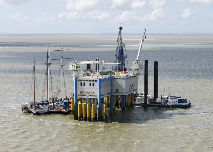
Fig 7. Production platform Zuidwal, prospecting for natural gas just next to the volcano, is one of the suspects to have caused instability in the underlying bedrock (image: blog.erwin713.nl
Another potential cause for unrest, both underground and above ground, is the mining for salt. In the province of Friesland you can find a salt industry that extracts salt from deep caverns under the Wadden Sea as well as in Delfzijl and Veendam in Groningen. They use vacuum salt technology: you pump water into the domes that lay deep in the underground and pump brine out. Near Harlingen, at around 10 km from the Sûdwalvulkaan, salt is extracted a a depth of around 2800 meters. The company and other parties involved try to sell it off as sustainable, because in the future gas, CO2 or oil can be stored inside the caverns caused by the salt extraction. The company recently received a permit from the Dutch authorities to extend their operation under the Wadden Sea to a larger area. The subsidence that will result, is a ‘calculated risk’, while critics who did their own calculations warn of a much larger subsidence than foreseen in the official reports.
Taken together, the effects of gas and salt extraction may well give similar effects as that of isostatic rebound, which is known to lead to an increase in volcanic activity. Whether or not the recent signs of unrest are true signs of the Zuidwalvulkaan reawakening or merely the effects of man’s exploitation of natural resources will have to await further study, Professor Eisinga concludes.

Fig. 8. Zuidwal Volcano, cross section and depth (Image credits: NITG – TNO; Source: NPO Wetenschap)
Further reading on the Zuidwal Volcano:
https://www.dinoloket.nl/zuidwal-volcanic-formation-xxzv
/Fopke Brandarius


Even after ten years, this article still pops up somewhere and makes me laugh. The dutch nu.nl has an article about fake Google-reviews today, but hasn’t got a clue.
I woud quickly die of boredom in flat Holland.. really one of the planets very most industrialized and most man altered artifical grounds that there ever is. Its almost as fake and artifical as Dubai is. Thats saied Neatherlands haves a wonderfuly rich culture and art and architecture history. But it really lacks wild nature and landscape scenery being as flat as a pancake and having neither mountains, forests, volcanoes, or wild areas.. its very industrialized indeed.
I beg to disagree on some of this. Remember that the Netherlands is a river delta, which is why it is at sea level. The alteration was by water and everywhere you can see how land and water interact. Much of the country is not industry. I grew up in an agricultural area with many lakes, far from the big cities. And there are forests and there are hills – just not near the main airport. And if you want to see a wild place of nature and life, see the Waddenzee, a 10,000 square kilometer estuary stretching halfway to Sweden where the sea takes on the role of the river. Boredom comes from not seeing.
There was indeed a lack of volcanoes. But now we have Zuidwal!
This is really wonderful, one of the best April 1st I believe. Very well written. I must admit that I believed it first.
In case you have any contact to Carl – he might appreciate this very detailed knowledge about Lake Kivu and surroundings, he seemed very into the problems when Nyiragongo erupted:
https://responsiblestatecraft.org/congo-rwanda-peace-deal-2673888064/
“Neither the Washington deal nor the Qatari agreement between the M23 and Kinshasa have had much effect on the ground. —– Moreover, M23 forces have continued killing civilians: the U.N. human rights office has documented how the rebel group, aided by members of the Rwandan army, killed at least 319 civilians between July 9 and 21 in the North Kivu region — most of these local farmers camping in their fields during the planting season.”
If it were not so sad it would all be funny. Unfortunately it is sad. Only DT believes it can work.
Mostly a boring flat landscape of farmlands .. but I agree that NL have alot of beauty souch as architecture and cultural stuff. Amsterdam is stunning really
Dutch landscape is flat, that goes with the geography, but their farmland isn’t boring. The US midwest might be considered boring ….
Its just me that wants crazy geology and crazy scenery…
Mostly a monotome flat landscape of farmlands same weather as UK and Norway and Malmö .. but I agree that NL have alot of beauty souch as architecture and cultural stuff. Amsterdam is a stunning city really with its canals and buildings
If all you have seen is Amsterdam then you have missed the country. Like seeing Sweden and visiting only Malmo.
I like Gouda The town a lot. And Delft. And Zeeland with Middelburg. And the Zuiderzee with Marken and Broek. And the waterways and windmills. And Pannekoeken. And De Hoge Veluwe with Vincent van Gogh. And Rembrandt in the Rijksmuseum. The Oranje Team. The tulips in spring. The West Frisian Islands. The beautiful light which comes in from the sea. And above all the friendliness of the Dutch.
You are missing some here Jesper. Go biking in the Netherlands. The Dutch make you feel happy.
Google Earth and streetview is useful to explore
I live in the northeastern part of The Netherlands. The Netherlands do also have beautiful nature and rural sceneries, for example the Veluwe in Gelderland, the rural countryside in the eastern parts of The Netherlands in the counties Drenthe, Overijssel and Gelderland. And the tectonic active region of Southern Limburg with occasional earthquakes due to the Lower Rhine Rift System, see https://www-weerverteller-nl.translate.goog/verhalen/opnieuw-een-kleine-aardbeving-in-zuid-limburg?_x_tr_sl=nl&_x_tr_tl=en&_x_tr_hl=nl&_x_tr_pto=wapp&_x_tr_hist=true “Another small earthquake in south Limburg”.
Thats very pretty looks like the gentle hills of an english countryside really and of course the same weather too…
Agreed. Wonderful country. It has its volcanoes in Indonesia, now independant. But there is still Dutch history there.
Near the coast it is sort of Venetian. I love the water culture. I know people in Waterland. They have two cars and a boat. When they have to go to Amsterdam they tend to take the boat. I love that.
I can also see one single fault in the Dutch 😒: That they ate up the Dodo.
(Albert will object to this)
Dubai is 100 times more fake and fakery than Neatherlands is they ( the larger modern cities ) haves almost no long history at all behind it, its little of a parody of the 21 th centruy and a parody of the modern consumer society. I also finds the choice of super – modern architecture questionable in Dubai .. they coud have built something traditional arabian and beautyful. But Persian Gulf is nice to swim in with +36 c open ocean water temperatures possible in summer!
The only volcano in Dubai will be a mud volcano spewing out methane and oil in some gas field
The sea only gets that warm because its so very shallow. The highest officially recorded sea surface temperature in the Persian Gulf was 37.6 °C (99.7 °F) in Kuwait Bay on July 30, 2020. The shallow sea gets very warm in the hot arabian summer, its an ultra hot version of the Baltic Sea very much hot shallow inland sea
Baltic Sea is in far worse shape in ways of water quality, we suffers from extreme nutrient overfertilization, this is so bad that I have not been able to swim since 2010 not fun when the entire ocean looks like a shrek pond
https://www.youtube.com/watch?v=v8Bt1djgZhk
https://www.youtube.com/watch?v=vr_Lb-WsY4Q
https://www.youtube.com/watch?v=HuIeF7pkGcM
And Norway is apparently crystal clear in some seasons! I have never seen any cold sea before being as clear blue as this, it clearly gives a tropical impression but Hawaii is much clearer still, still for being a cold sea ( these are normaly green and murky ) this is crystal clear. Maybe in winter there is less plankton
I will have to dive in Norway later I have never tryed that.. very underestimated. I guess diving in Tasmania will look almost identical but not soure what Chad says, west Sweden is also spectacular salt marine fauna but murkier than Norway.. but Baltic Sea is disasterious too much pollution and very little life can live in braskish water
Yes, dive in Norway, but read this first.
https://en.wikipedia.org/wiki/A_Descent_into_the_Maelstr%C3%B6m
by Edgar Allan Poe
Thrilling
Not true. The Netherlands have the Waddenzee, that’s one of nature’s gems. Full of sea life. The tides make it special.
I’ve been visiting Zuidwal since my time in the first French army, beautiful place!
We thought this was quite a good joke – admins
Bad joke, admin please a
I am curious what you wrote there. Too bad.
Yesterday this was big in the Dutch media: Google is removing Google Maps reviews for visits to a volcano that cannot even be seen! They published some of these reviews in their articles and these were simply hilarious. Albert and I had a good laugh too, and said, “have we brought that about?”. Because back in the day, we wrote the original April Fools piece on de Zuidwal Volcano, and there was very little information available about it online, just a few articles, mainly in Dutch. So very few Dutchies had even heard about the fact that we have this extinct volcanic giant lurking beneath our feet when doing low-tide walking excursions on the Frisian see. It’s a pity we can no longer see the stats of the original piece, but back then it was visited a lot. And since we wrote it, many more pieces have appeared online and the existence of the Zuidwal Volcano nowadays is pretty well-known in the Netherlands. We modestly assume VolcanoCafé did its fair share in popularising armchair travel to the Zuidwal Volcano.
Maybe Google could just introduce a ‘Satire’ tag for these faux reviews. Because we all need a good laugh from time to time, and by deleting these comments a lot of creativity that people have invested in them, is lost forever…
I considered putting in a review myself but didn’t. It would have pointed out the presence of the northern mountain whale in the crater lake. Long ago they were present in the original caldera when it was below sea level, but when inflation raised the rim they got stuck, and as the mountain grew the whales became caught in the summit lake. Now they are the highest altitude whales in the world. Not bad for such a flat country! Over time they evolved to become much smaller, so now the Zuidwal whales are also the smallest species of whales in the world.
You are so considerate.
I would have taken to sharks.
The Great White population is said to have recovered and is seen close to the caost between Marthas Vineyard and Newfoundland. No joke.
May be Zuidwal is not the only buried volcano in the North Sea. There used to be a large active rift.
Viking Rift, Central Graben and Oslo Graben. Oslo Graben and its volcanism is older (Permian Age) than the Dutch volcano, but not buried, because Scandinavia had uplift, while the North European Plain subducted after the Variscan orogency.
Can we estimate how much UK migrated west during the North Sea rifting? If the rift had succeed, the UK would have become an actual micro continent.
In fact we may argue that the Netherlands were once the most volcano rich nation of the world … the Dutch Colonial Empire included present Indonesia with Tambora and Krakatau erupting during colonical times.
Although the Netherlands lost most of the Colonical Empire after 1945, they still keep some Caribian Islands. There you can find a real Dutch Volcano that erupted 1640: Mount Scenery on Saba island https://en.wikipedia.org/wiki/Mount_Scenery
They actually monitor this volcano. Maybe it’s a fortunaty that they can concentrate all their ressources on this volcano https://www.mdpi.com/2076-3263/8/9/320
Concerning the Zuidwal volcano it’s awsome how so many sediments could be deposited there above the volcano. There must have happened a subduction of ~2km in a graben. Was it linked to the Central North Sea Graben or the Rhine Graben? It is also a challenge to imagine, from which mountains the mass came from that buried the volcano.
The next volcanoes on surface are the Bonn (capital of West Germany) volcanoes called “Siebengebirge” (Seven Mountains). They erupted very much later than Zuidwal in Oligocene Age (33-23 million years ago). Dragon’s Rock (“Drachenfels”) above the Rhine river was formed as a subterranean magma dome that didn’t get finally to the surface:
https://www.der-drachenfels.de/assets/images/k/DJI_0240-natpy9y7n14hv0j.webp
Tambora erupted at a time the area was governed by England. During the French Revolution, England took over the Netherlands overseas regions. Afterwards they gave it back, minus Tambora which no longer existed. I blame the management.
They settled in the Cape and on Mauritius and missed one of the most beautiful volcanic islands in the world: Réunion.
They came from SA, stopped in Madagascar and missed Piton or staid away if Piton was erupting.
https://browser.dataspace.copernicus.eu/?zoom=14&lat=-1.40486&lng=29.21823&themeId=DEFAULT-THEME&visualizationUrl=U2FsdGVkX1%2BTs84z2tNZ%2F1mGW8vsCsmnNLKZ0ZOgjEiM4QOagkCW64j8kgOK20qnmht5y6g2ng0IreKNdLqVWy90DeWNVn0VKSEZt3M0csIxcrmnc5JUg4lrCYT5MNad&datasetId=S2_L2A_CDAS&fromTime=2025-02-24T00%3A00%3A00.000Z&toTime=2025-08-24T23%3A59%3A59.999Z&layerId=2_TONEMAPPED_NATURAL_COLOR&demSource3D=%22MAPZEN%22&cloudCoverage=30&dateMode=MOSAIC
Nyiramuragira having a huge constant pyrocumulus cloud over its overflowing lava lake, its the most powerful non stop surface lava eruption on the planet at current! thats saied the mammoth Kilauea may very well able to beat it once it gets into constant eruption later
It hasnt showed a crazy hear emission value for a while, clouds do a good job covering that up and absorbing the heat to fuel themselves, probably a very rainy situation up there, be it brave tourists or brave gorillas.
Kilayeas 2018 eruption had probably several km2 of glowing lava exposed at all time, yet heat emission fell after it started because the ocean entry plume went inland and back over. It was apparently the most intense storm ever seen locally, far more than any hurricane in rainfall. Anecdotally anyway.
Nyiramuragira really does looks like the gates of doom when its like this the massive pyrocumulus clouds are lit up by the red glow at night. A Goma FB friend climbed Karisimbi recently and gazed towards Nyiramuragira late in the evening: it was certainly a spectacular and unsettling sight I hopes he gets good photos next time
https://www.windy.com/sv/-SO2-tcso2?tcso2,-2.735,24.214,6
Strong sulfur emissions from Virunga its togther with Hawaii one of the worlds largest emitters of sulfur
Very gassy I hopes we gets photos soon of the lava lake in Nyiramuragira
From Arcturus1981’s comment at https://www.reddit.com/r/geology/comments/1h5tbbo/did_the_netherlands_ever_have_volcanoes/
I found an alternative definition of “ancient Netherlands” which of course would not be liked by any real geologist, because the actual land beneath has moved a lot. Moreover, that “coordinate-based solution” is not without its problems either, because we would need to know the exact rotation speed of Earth over the geological time scale, otherwise we would have fixed only the latitude.
But this made me recall the question I have asked myself whenever there are big earthquakes somewhere (like recently in Kamchatka with up to 2 meter horizontal ground displacements), or California with its San Andreas fault: How do the land-registers in those places work? I mean, surely you cannot just define your plot by the GPS-coordinates (if too hi-res), as after few big quakes that plot is not anymore inside the same coordinates?
Luckily very few properties cross a major fault line. Driving along the San Andres south of Palmdale, I noticed that properties were frighteningly close to the fault, but seemed to be on either side, not both. Coordinates tend to be applied such that the local tectonic plate is stationary. That is true on either side of a transform fault, so the potential conflict only applies to the width of the contact zone.
IIRC, Australia’s GPS co-ordinates have recently been up-dated to cope with that plate’s remarkable motion…
D’uh, bit like we used to check the ‘annual drift’ of ‘Magnetic North’ on UK’s OS maps.
A cousin’s spouse ran local Scout group. After he mis-applied map’s magnetic correction, orienteer group descended hill into wrong valley, had a glum hike to bus. The kids subsequently kept independent track…
Kilauea reinflated over 6 microradians since E31 ended. Its likely to slow as it gets closer to 32 but this is a faster recovery than last time. If there is a DI event before E32 it will begin after about 20 microradians, which could be in only a few days at this point but more likely around this time next week with a declining trend., and a couple days later if a DI happens, 10 days give or take. The fountain was vertically low but would have been another 300 meter giant if it wasnt diverted. The presence of tge new intermediate vent also suggests the diversion might be failing, and some point soon (E32-25) it blows out the top or the vents all merge.
Fun stuff In the future the vent will likley merge into a gigantic open maw a huge roiling overflowing mess of dome fountains like Fagradalsfjall but many times larger. That will only be a thing if the vent pipe gets wider which is likey many years off and it may not happen at all. Fun stuff and IF nothing changes at the summit or the rifts or in the vents .. then Kilauea can do these fountains for the rest of your life but its an chaotic and unpredicatable system so something with the vents at least will likley change in the comming years
It probably will become a wide open overflowing lava lake, the only thing stopping that is a collapse, and that will happen as soon as magma leaves the summit even if only temporarily. That is what happened at Pu’u O’o, it had to have a flank vent form and collapse the narrow main vent. Although, the final failure in 1986 was about the 20th time a flank vent opened from it, so its actually hard to kill a fountaining vent, and Pu’u O’o was directly on a rift zone with weak zones connected both sides, the current vent doesnt gave either.
One other thing that might happen, the inclined fountain has started building another tephra cone on the north side, and its possible eventually the lava will be impounded by it and back up over the north vent. Or the tephra piles up enough to start flowing into the north vent from that side. That might result in vertical fountains again, but it might also just divert supply to the south vent instead. Its very dynamic and basically every episode changes the terrain so much. Its still barely been 9 months, this could last multiple years, the summit might well overflow before fountaining stops.
This summit vents formation back in christmas is very diffirent than the summit vent that formed in 2008 its another situation now with Kilauea and how Kilauea is vented these days. 2008 – 2018 vent was basicaly the chamber roof that where falling and melting into the upper magma chamber column this coud be analogus to a spectacular example that is “geological stoping” thats also is in line with hectors musings on the DI events. That process very much explains why the overlook lava lake became so large so very early through collpasing into the uppermost magma chamber and it of course was still growing by 2018, most of the time it never overflowed it was robbed by Puu Oo s suction constantly.
The christmas 2025 – current open vent is a little diffirent it formed through a quite narrow dyke that cut itself upwards to the surface and not through a collapse into the magma chamber like in 2008 this have to melt itself wider which seems to be a rather slow process indeed explaining the high fountains due to gas and lack of a flank vent downhill that taps magma. Thats saied Its very intresting all the glowing spots and side vents around the main vent, there are many vents active now in Halemaumau perhaps that coud be a sign of a very weak magma chamber roof. If thats the situation then the whole thing may indeed widen and collpase into itself like it did in 2008 becomming a massive overflowing lava lake. Its also possible the cracks and extra vents coud also be because the eruptions simply melts more pathways upwards
I think it has long since stopped being a dike, probably back in January if not last year. Its a round tube now, or two parallel tubes. It seems though that if there was two vents, it is probably now basically a single vent with multiple diversions at shallow depth, and getting shallower each episode. E32 or E33 might be where it blows through and becomes a single vent.
Yes its a round tube now starting to look a little like Fagradalsfjall but with unlimited magma supply 🙂
Big Island is AMAZING its my favorite Island for many reasons but its criminaly hard to live in almost impossible with jobs and healthcare and other systems so… I will have to do with living in Iceland thats a realisitc goal to live in as young
You might consider the wonderful island of Vlieland and organise guided tours to the Zuidwal Volcano!
https://vlieland.org/en/vlieland.php
VERY pretty indeed! reminds me of sunny beach towns in Denmark thats saied I woud really want to live in Iceland where Im free resident
I live on an entire continent without a volcano. Best I can do is the Kiwi volcanoes (thanks Mike Ross!) and Heard Island, which doesn’t really count.
So the Dutch can take their volcano imaginings and well, imagine them.
I loved wandering around Warrumbungle. A beautifully excavated volcano putting its innards on show. If you want to see what a dike looks like, walk the Breadknife. The only problem is those *censured* kangaroos which keep jumping in front of any car they see approach. Size of a deer and intelligence of a rabbit.
I’ve walked the Breadknife. Even posted a photo of it onto VC once!
No kangas here, but I fed my brushtail possum lady an hour ago. Marsupial. She gets half a slice of bread and a carrot for afters. Young one has been out of the pouch for a couple weeks and is riding on mom like a jockey. Spring happens in a week! Very nice day today, warm and sunny.
Undara is an active volcano, last eruption 7000 years ago, and it is potentially an embryonic central volcano that might one day become a massive shield topped with a caldera like Mt Warning used to be, or like Newberry or Medicine Lake today. Id say that its present form certainly counts by all definitions still. Its unlikely to do anything for at least that much longer though but who knows.
Atherton is also active though I dont know if a holocene vent is confirmed, there are several vents in the late Pleistocene to early Holocene. Toomba is also about the same late Pleistocene age, though the first vent in its field for at least half a million years so maybe not a repeat… Obviously there is Newer Volcanics, which is the most likely one to go next, even the next 1000 years is pretty plausible but only thing for certain is it wont erupt this week, after that is technically fair game 🙂
If you want to be technical too, all the volcanoes of Papua New Guinea counted as Australian between 1946 and 1975, and that includes a number of eruptions including Mt Lamington in 1952. Mt Lamington is on the continental island of New Guinea, and is also on the Australian plate, so if not in the country it is still incorrect that the Australian continent has had no historical eruption on its shores.
Some Australian lava flows are huge too and lasted years if not decades some tube feed mafic lava flows are about 100 kilometers long, infrequent but large eruptions
One of the curious things about the last two massive flows in north Queensland is the eruptions went in reverse to the expected trend. Kinrara is the youngest vent of Undara (McBride field), and it began seemingly as a single vent that slowly flooded a huge area up to 50 km away in inflated pahoehoe. But as tbe eruption ernt on the intensity got stronger,the youngest flows are massive a’a lava tongues that go over 20 km away on flat ground, being at least as big as Holuhraun, and overwhelming the lava tube system. Its like a slow eruption suddenly turned into a fast lava flood but kept the same vent, like it had a 1000x increased eruption rate…
Toomba also did this, the earliest flows were the longest and sequentially got shorter. But the youngest flows and the vent structure itself are tge product of much higher effusion rate than earlier. The lava composition also changed at times. Toomba might have been semi-polygenetic, erupting for decades or even centuries with multiple big eruptions of different lava composition. Although its change was still not nearly so drastic as at Kinrara.
Yes there are many enormous continental mafic flows in the world…lava flow lengths of a 100 kilometers are not uncommon
Yes, its like a small low rate LIP, though not a traps event of course. The province is also pretty old, theres a Pliocene fossil bed in the Nulla field that is the parent of the Toomba volcano, it was possibly more active then but clearly not dead. But the source of the magma is very robust, its not going away any time soon.
See also https://npo.nl/npo3/3opreis/internet-gaat-los-over-zuidwalvulkaan-in-nederlandse-waddenzee “Internet gaat los over Zuidwalvulkaan in Nederlandse Waddenzee”.
What a yoke here in The Netherlands.
Episode 31 had ~10 million m³ and lasted for 12.6 hours. The volume grew by 25% from Episode 30 (8 million m³) to Episode 31. Did the lava field grow in any direction?
After steep inflation the tiltmeters now observe zero deformation. Is there an error or has the inflation really stopped?
Unless HVO says its instrumental then the tilt is a real signal, its probably another DI event with the D cancelling out the rapid recovery from E31. In a day or two if this is the case the tilt should shoot up to about where it would be following the trend before the DI started, roughly net 0 change. That is, probably shooting up between 5 and 10 microrads in a day, crazy. If that doesnt happen then this could be something else.
But the abrupt change is consistent with a DI, if magma was going somewhere else deflation would be much stronger and inflation would happen in another location. And if the whole supply slowed that would be a gradual thing I would think.
HVO released new images, one of them shows the overhanging vent. To be honest, it looks like the original north vent is actually dead and a new vent has erupted through the south side of the north crater, and that the source is between the two formerly separate vents, which are now probably merged to a very shallow depth.
It looks like a DI event. It is new behaviour, so early in the recovery phase
What do the DI events mean for the future development of the episodes? Should we expect more random or chaotic behaviour? Or do they lead to the opposite: a future steady eruption like later Pu’u O’o stages?
Wait and see. The DI events did not affect the last two episodes, apart from 1-2 days delay. But the system is changing over time
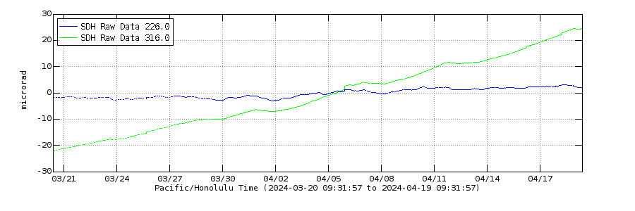
SDH tiltmeter shows that the average level of deformation has increased towards Episode 31 by 3-4 microrads in the southern district of Kilauea’s summit:
 ?fileTS=1756283013
This indicates to me that magma is going more towards SDH than UWD at the moment.
The centre of inflation may be shifting a bit to the southwest
The Starship launch was a partial success. It did not explode! Although at one point it did appear to try, and the new flaps were flapping a bit. Still some way from being able to get to space.
It did get to space, what you probably meant is take people to space 🙂
… and back. Alive. And then all those tanker flights, to get even to the Moon.
It did not get into orbital altitude (and wasn’t meant to). An essential part of going to space is being able to stay there. Otherwise it is more like bungee jumping.
It got above the atmosphere, if it carried people they would be astronauts or similar, so I think it counts. When the heat shield is reliable is probably when a true orbit will occur, or if they start launching Starlink satellites with decomissioned upper stages to dispose of them.
I still think that just putting 100 tons inside a gigantic fairing on tne superheavy booster is a pretty viable option. The booster is very reliable now as are the engines, so its just a massive Falcon 9, you could launch the ISS replacement in 2 launches on it…
It’s not really the heat shield that prevents them from going into a stable orbit but rather orbital flight control and reliable engine relight needs to be demonstrated multiple times in a row first. The last thing anyone wants is Starship stuck in a decaying low Earth orbit until bits of it randomly “lands” on someone’s house.
Technically it was at orbital altitude and velocity, and the flight director called that at one point in the coverage. But the trajectory was designed to splash down off of Western Australia on purpose. And they landed/splashed down right next to the video bouy too. No problem doing a few orbits – that was what the Raptor relight test was about, so they can deorbit on demand.
I’m just about to watch, live, a humble Starlink launch. In 10 minutes time. The reason is that this is the 30th flight of that particular booster. A record I think. No one else can do anything like that.
Somewhat random, but I was perusing Google earth, and I realized a volcano that while not very active, is a *potential* very high threat volcano to very large population regions. To the point where a VEI-6 could cause very very large problems.
That volcano is none other than Methana. The main reason for my thoughts here are that a significant sized eruption would pose a very large tsunami risk to Athens and the surrounding Greek coastline, which is heavily populated. And while this volcano is very rarely active, it IS a rhyodacite dome complex, which may indicate a potential for a large explosive eruption.
All that said, I would guess the rhyodacite is probably more a product of long periods of fractionation in a smallish magma chamber. It’s probably not much of a risk since I do not think this volcano is vigorous enough to do much – most of the activity looks like dome building and smallish lava flows, but you never know.
Methana has 2 chambers the upper silic chamber js fed by a deeper larger mafic chamber. Unaware of how molten it is but I doubt it’ll try to pull something.
Agreed. Just found it interesting. I try to note volcanoes that are potentially high-risk if there were a large eruption in the VEI-6 / VEI-7 range. Not because it’s likely that said scenario would occur, but simply due to the consequences of what would happen IF that scenario actually does become possible.
Unrelated, how much magma do think is in the intrusion at CCN?
No clue. Too many unknown variables to be honest.
Out of curiosity, which volcanoes do you think are potentially high risk VEI-6 / 7 producers that *are* likely to erupt?
From what scant research I’ve done, I’ve figured the general areas / arcs with the highest chances of such a large eruption are the Aleutians, Kamchatka, and the Sunda Arc (specifically either Sumatra or the Lesser Sunda Islands) given their relatively recent geological history.
How many years before Tambora’s great eruption 1815 could we have predicted this with modern scientific tools?
Several years before the 19th century Krakatoa eruption, the geologist Verbeek visited the island. He came back concerned. Although he did not expect a very large eruption, he saw something there that indicated this was not a good place to be. We don’t know what it was. However, the island had been occupied in the past but was abandoned perhaps 50 years before the eruption. Again we do not know why. I think it was inflation which put the water wells out of reach. At Mayon, the wells tend to dry up around 6 months before an eruption, because the ground inflates but the water table remains at the same level. At Tambora, the summit started to show a perpetual cloud some 5 years before the eruption, indicating increased heat flow. At Vesuvius, the sign was earthquakes. At Santorini too, and here the signs were strong enough to cause evacuation of the island before the eruption. So no single answer but it seems to me that there are signs. The explosion does not come completely out of the blue.
Hunga Tonga though was different; it had a normal eruption which suddenly went ballistic due to (I think) a flank collapse. That was unforeseen. Verbeek expected Krakatoa to erupt (I think) but had not expected such devastation. The hardest part may be to predict which ones will suddenly go big. That may even be impossible because it involves a random failure.
The other problem is to make people take the warning seriously. The 2018 collapse of Anak Krakatau was predicted and it happened almost exactly as predicted. Monitoring could have seen it coming weeks ahead of the disaster. But it wasn’t seen as a threat. When people like with danger for too long, they start to forget about it or even deny it. We see that everywhere. ‘No, Russia is not going to attack’ ‘No, the US will not ban vaccines’ ‘No, climate change doesn’t affect us’ ‘No, that wild fire is not going to come here’ ‘No, that volcano is safe’. It is human nature in action. The cost of action is too high, so inertia takes over.
That is by its nature hard to predict, as this will in general be volcanoes that have been quiescent for centuries. So look for the ones no one else is talking about. That does actually put Tallis’ CNN on the target list: it fits the signs to look for. Second is the slightly submarine calderas, as Hunga Tonga has shown what they can do. Think Iwo Jima. Finally, nice looking volcanoes with unstable flanks. St Helens once was in that category. Our NDVP list may be a good start! Look at the top of the posts, rightmost menu item.
I’ve read over that list many times along with a bunch of other related articles published here. I was curious if there were any updates or changes to which volcanoes should be on that list, or to the volcanoes already on that list, since the articles were published back in 2015.
Pick volcanoes that do large eruptions of relatively fluid and crystal poor magma, and over a wide area with homogeneous composition. Lots of caldera progenitors, and repeat offenders, are also actually very active, and we just saw a caldera volcano in Kamchatka erupt after 600-1000+ years dormancy with an effusive eruption, so I think the dormancy argument is more misleading than anything.
Also, totally disregard magma viscosity and composition, the most recent VEI 6 was a mafic volcano, which blew up with a much bigger bang than anything since the 1880s, and is literally neighbors with two erupting felsic volcanoes in the same shallow sea, and are both entirely non explosive…
I’d look for something out of the norm that segregate a volcanic unrest from another. Corbetti for example, doesn’t concern me in the short term. It is following the typical caldera resurgence with main.point of interest being that it seems to be further along than most. The thing is that CCN’s deformation was always odd and that clued me into something not being normal.
Chiles-Cerro Negro’s unrest is not normal in the slightest the crack portion of the intrusion is 18 km long and 4-6 wide and extends 2-6km from the magma chamber giving us a volume of 113-340 km3.
Iwo-jima is also anything but normal. It’s hard to pinpoint what exactly is going on but my guess is that there’s a persistent transfer of magma between the deeper chamber, shallow chamber and sill. Persistent is an understatement considering this has likely been going on for 800 years. Currently the W part is heading east and E is heading W while still uplifting.
Look for persistent oddities that lack simple explanations
“The intrusion is 18 km long and 4-6 wide and extends 2-6km from the magma chamber giving us a volume of 113-340 km3.”
I think the unrest is most likely happening along an established plumbing, not a new intrusion. Do consider Kilauea has shallow magma a few kilometers below the surface over an area 50 km long that regularly produces inflation and earthquakes, but obviously is not a contender because the magma is just in thin dikes and sills (meters wide at most).
Speaking of the NDVP, a revisited/updated or expanded list would be very interesting in my opinion.
They are some of the most interesting articles posted here.
Hector, aren’t all persistent intrusions “plumbing features.”? This isn’t a network of sill and dykes. It’s a rupture, the magma chamber has ruptured and is continuing to expand it’s crack. That’s completely different that what’s happening at Kilauea.
How often does the Katmai/Novarupta complex do large Plinian eruptions like 1912?
@Caeric
It would be a very neat project to see if the NDVP could be updated with either new entries, or updates on the volcanoes already on there.
Unzen (if it can go big), Tatun, and Ulleung-do would be bad.
Laacher See? Could it blow any time soon?
Some people pray that they would live long enough to see humans on Mars, while I just hope that I could see a portion of a big city buried by lava and ash. Not that I would have anything personal against the residents of Napoli, Auckland, Kagoshima, Taipei, Quito, etc.
Laacher See and region is out of the race for next >100,000 years. The last eruption feels like yesterday, if we look at its rythm of great eruptions. More likely is a Maar explosion/eruption in the West Eifel (VEI3).
Campi Flegrei are a dangerous volcano. Even a moderate VEI3 could destroy and hurt much of Naples.
Maybe towards the end of the century Örafajökull (Iceland) will do a Plinian eruption again.
Alaska and Indonesia have many volcanoes. If the probability per volcano is at a certain percentage, it’s likely that one or the other will do a major Plinian next in this regions.
Very interesting, cbus. Now that I look at it, the mountain is very obviously a laccolith in shape (of around 9 by 7 km) with an uplift of at least 800 m in the center, and a marked axial cleft.
Yeah previously I hadn’t ever thought much of it since most of the Greek volcanoes aside from Santorini / Columbo are simply not every active. And there isn’t really much to write about this volcano. But seeing that it’s a decent sized Rhyodacite dome complex that isn’t all that far from Athens AND located on the water caught my eye.
Creating a new response thread to respond to this quesdtion. “Out of curiosity, which volcanoes do you think are potentially high risk VEI-6 / 7 producers that *are* likely to erupt?”
I think there are a few considerations you would have to account for when trying to put together a speculative list like this. I’ll post a speculative list in a followup response to this.
1. Has there been any recent unrest / activity? This would indicate potential for an eruption, which would *potentially* be large. That being said, volcanoes that erupt big often will lie dormant for quite a long time. These volcanoes WILL show signs of unrest prior to a large eruption, but the time frame before a major eruption is not always that long, or may go unnoticed due to no instrumentation monitoring said volcano. Most volcanoes I would list as a high risk would not qualify because they haven’t seen a whole lot of recent activity.
2. Does the volcano even have the potential to form a large eruption? This requires enough stored magma and pressure built up for an eruption to form a large eruption. It can also occur if you get a large edifice that is at risk of failure when a new intrusion pushes up. This becomes a lot more speculative, and is based on a lot of variables we simply don’t have the ability to know for most volcanoes. Unfortunately, we still do not have an easy ability to measure sizes of magma chambers, let alone how much of that magma chamber is in an eruptible state.
From point 2, since we don’t have the ability to image and measure how much eruptible magma and pressure is underneath each volcano in the world, we are left with speculating on this, from which we can consider a few factors.
1. Has the volcano had a history of large eruptions in the past? While volcanoes can and do change their behavior, past behavior is typically a good indication of what is possible in the future. The caveat here is that if there was a geologically recent caldera formation, then it’s not likely that you would see another caldera formation sized eruption in the near future since it would have to rebuild the shallow magma chamber bit by bit. Personally, I also think that it’s helpful to not only look at individual volcanoes, but also how nearby volcanoes behave since they typically exist in similar geological environments, and thus can exhibit similar behavior. Another caveat is that for every repeat large erupting volcano, there was a “first” time for those volcanoes.
2. What is the magma composition? While not always the case, larger vei 6+ eruptions most often are comprised of more viscous magmas. There are plenty of VEI-6+ andesitic eruptions, but more viscous magma compositions are more likely to form larger eruptions and to become plugged up, leading to intense pressure buildup.
3. Is the volcano large enough / prolific enough to have a magma chamber sized for a VEI-6 eruption? This gets to be a bit more speculative, but you can look at edifice size, magma output, and perhaps get a rough sense for whether a volcano could produce a caldera-forming eruption.
4. Is there any potential for structural instability? This is more reserved for tall stratovolcanoes, often of andesitic composition, but edifice collapse is frequently a catalyst for enormous eruptions. An edifice collapse can turn a small intrusion into major vei-6+ eruption. For this, I would say you would probably look for tall volcanoes with steep a steep relief structure. Erosion caused by glaciers can also contribute to instability.
Some volcanoes that I think would fit a risk profile of having recent activity, and also having a risk of creating an eruption in the size range of VEI-6. Note, this just a small speculative list. Clearly there are MANY other volcanoes that theoretically could erupt in a VEI-6 within the next 10 years.
1. Iwo Jima – I’ll just leave the link to the Volcanocafe NDVP article here instead of writing about it more. https://www.volcanocafe.org/the-new-decade-volcano-program-no-1-ioto-japan/
2. Chiles Cerro-Negro – Hard to know if it could produce a VEI-6 sized eruption or not, but I do think it’s possible. The big wildcard here would be if there is an existing shallow magma chamber, and if so, how large that magma chamber is. If the existing large intrusion can mobilize a significant sized shallow magma chamber, then you could probanly get enough eruptible magma for a VEI-6, but there are a lot of unknowns here.
3. Mt. Edgecumbe – This is not a well-known volcano, but some may remember there was a significant intrusion into this volcano a few years back. Nothing ever came of the intrusion and the alert level was dropped back down, but I still think this is a high risk volcano for various reasons. First being that it’s huge, second being that the eruptive patterns that we know from this volcano have followed a pattern of increasing explosivity and size, all while seeing increasing viscosity in magma composition.
4. Shiveluch – Shiveluch has been the single most prolific eruptor of VEI-5 eruptions in the Holocene period. It’s an enormous volcano with a VERY prolific magma source. In the last 2000 years, the overall output rate seems to have increased a slight bit as well. On top of that, the magma composition has both dacites and andesites, and has a very high water content, which contributes to explosivity. On top of that, this is a past caldera volcano. Given, while it has produced a LOT of VEI 4 and 5 eruptions in the Holocene, it hasn’t produced anything larger. Most of these have been a product of building up large domes, and seeing subsequent large eruptions after the domes collapse. That being said, there has been nothing that has damaged/destroyed any underlying magma chambers, and those have surely been growing. All in all, I would not be surprised to see this system to take the next step and create a larger sized eruption in the future.
5. Laguna del maule – this volcano has been covered a good bit, but it’s a past caldera volcano that has been undergoing ongoing inflation for quite some time. Speculative as to how much magma is available for eruption, but if the ongoing intrusion were to shift into potentially ramping up towards an eruption, it would be very possible to see a VEI-6 here.
I think the most difficult type of volcano to speculate on for a potential larger eruption is the many volcanoes that are experiencing ongoing small eruptions, but clearly in the past have built up to much larger eruptions (most with calderas to show for it). There are a lot of examples of this in places like Indonesia, where a volcano like Ijen regulary sees small activity, but exists as a somma of a massive 15km caldera. Another example of this type of volcano would be Popocatepetl, which has just seen small strombolian eruptions over the past 20 or so years, but clearly has behaved very differently in the past. I think the consensus is that volcanoes like these which would be classified as “open vent” systems probably wouldn’t build up to a large scale eruption until they potentially became plugged up, and thus were unable to relieve any building pressure. That being said, there are instances where volcanoes seeing ongoing eruptions suddenly shift into a much more explosive phase, so I don’t think you can definitely say these aren’t a risk for creating something larger despite them being open system volcanoes.
And the most important note is that it’s extremely likely the next VEI-6 or larger will come from a volcano that is not currently experiencing unrest. Some can go from rest to eruption very quick. Others simply are not monitored much at all, so we just aren’t aware of what unrest is going on. See Hunga-Tonga as an obvious recent example of this. I’m sure there have been many more similar eruptions to the Hunga Tonga eruption that we have zero record of, so those probably occur much more frequently than we realize, especially given how many volcanoes exist that are similar in profile.
Are the open vent volcanoes Etna and Stromboli also capable of doing VEI 6 eruptions and do they have enough magma storage to accomplish this?
Stromboli, it would surprise me. But Etna it is plausible. Although it is known that Etna also lacks a shallow system at present. It has got a caldera from an eruption in 122 BCE, VEai 5, its not as effusive as it looks, but it isnt currently in a stage where anything bigger than that is really possible.
Only volcano in Italy that seems plausibly able to do a VEI 6+ right now is Campi Flegri but it isnt showing signs its about to demonstrate it.
“Only volcano in Italy that seems plausibly able to do a VEI 6+ right now is Campi Flegrei”.
While not right now (and not as likely as Campi Flegrei) with some decades of awakening, Pantelleria, Ischia or Lipari might, and with some centuries of magma evolution, Vesuvius might too.
Some years ago you did a great article about a dangerous part of Italy’s volcanoes: Latium Volcano and Vulsini, the volcanoes of Rome. The “Eifel” of Italy, maybe active on a similar timeline, but with the ability for a more frequent VEI6 than the Eifel.
@Volcanophil Are any of the Lazio volcanoes bar Colli Albani actually showing any signs of life?
No, but it’s difficult to predict when they’ll awake again. Volcanoes like these can surprise us. How well are they monitored?
I would presume mostly passive monitoring such as InSar or if the regular seismic monitoring seismometer network detects any unexpected going on there. I doubt they have the budget to do extensive monitoring on every volcano just in case.
No, Etna is primarily basaltic, and does not form large magma chambers. It’s very well studied and understood. Just the nature of it is not conducive to form the types of magmas you would need to see a large eruption in any type of geologically near future. Stromboli is. a little more explosive / viscous, but I still would doubt a sudden change in behavior.
I think the only risk for these two volcanoes in any type of geologically near future would come from edifice failure / landslide / collapse. Etna has a large collapse scarp I believe, although in general, the low relief structure of the volcano means it’s not really likely to collapse ALA mt. St. Helens. If there were a large landslide, it would be more of the slumping Hawaiian style, although those are exceedlingly rare.
Not a VEI6 eruption, but in absolutely worst case a collapse eruption with dangerous tsunami in Mediterannean Sea.
Stromboli sits in a caldera with the size 1800 meters × 3000 meters, that once collapsed. Stromboli has a similar lifecycle like Santorini and Ana Krakatau of collapsing and being reborn, but between these worst case events Stromboli is the gentle volcano that we know. One of the precursors of Stromboli is Strombolicchio, of which we only see the rock of the frozen magma dyke.
5,000-6,000 years ago was another smaller partial caldera collapse that left the Sciara-del-Fuoco depression behind. The landslide & tsunami 29th December 2002 reminded to this risks.
“I think the consensus is that volcanoes like these which would be classified as “open vent” systems probably wouldn’t build up to a large scale eruption until they potentially became plugged up, and thus were unable to relieve any building pressure.”
I think Hunga Tonga 2022 obliterated the idea (at least for me) that a long dormancy is needed for caldera formation, and that Shiveluch 2023 obliterated the idea that any sort of dormacy is needed before a plinian, a volcano can suddenly switch from effusive to explosive.
Yeah, I generally agree with your statement, which is why I even specified mention that there are plenty of examples where being open vent does not prevent a shift in behavior towards a larger eruption. Even Krakatoa is a good example of this.
The only difference between a plinian eruption and a lava fountain is how liquid the lava is when it lands… some of the Etna paroxysms of recent years have really blurred the line, making both long lava flows AND the characteristic tall stem with a wide cloud at the top, which Pliny the Younger would have no doubt called ‘plinian’ per his original description, including a few of them experiencing column collapse or flank collapse and generating long pyroclastic flows too. Basically the entire spectrum in a single eruption, no magma change required either.
Viscous volcanoes like Shevluch might not be able to do that transitional stage though. They can be mixed explosive/effusive but the explosive part is still complete fragmentation and not a lava fountain. It seems if a volcano with viscous magma is capable of exploding, it will do so if eruption rate is high enough.
If we are looking for deadly volcanic disasters, most future events are likely to come from a small sudden explosion (Stromboli, White Island, Marapi, Ontake), a debris avalanche with or without lateral blast or tsunami (like Krakatau 2018), or a random PDC from cone or dome collapse (like Fuego 2018 or Semeru). Or, in terms of material damage, lava flows or PDCs from plinian or dome-building destroying a town.
But if we look for a caldera-forming event then I think Ioto/Iwo-Jima is by far the likeliest to do anything immediate: A massive resurgent dome filled with trachyte magma and a size that could do an explosion larger than Tambora, which is also the only caldera volcano that is actually erupting from the ring fault itself, other volcanoes like Campi Flegrei or Rabaul erupt from the cone sheets instead, and with a vent that seems to be trying to widen/become polygenetic. The ocean will likely scrape away most of the SO2, so I doubt the volcanic winter will be too significant; however, it could cause a devastating tsunami, not to mention end any life on the island itself.
Other than Ioto, I don’t think any volcano is showing particularly concerning signs of an immediate explosive caldera-forming event, but there are many candidates that could produce caldera-forming eruptions in the future. I would look for volcanoes that may have a laccolith or piston inflation (pistolith), Methana being a good example since it looks like a laccolith; or calderas whose floors might have rebounded through inflation, Hunga Tonga being presumably a case of this. Composition (having a magma that’s more evolved than nearby volcanoes) can be a sign, with rhyolite/trachyte being almost exclusive of shallow crystal-poor magma chambers, but it may not always be too clear. Crystal content would be useful if it were regularly reported on articles, crystal-poor being characteristic or calderas and volcanic fields as opposed to crystal-rich rich that is typical of regular stratovolcanoes and calderas of under 3 km. A ring of vents is also useful, since there will be a magma reservoir inside, but not always present since some calderas prefer making a linear swarm of vents or erupt mostly from a central crater. There are likely tens (if not over a 100) of volcanoes that fit these conditions.
Some volcanoes like Masaya, Taal, Ambrym, Izu Oshima, Sierra Negra, Kilauea, or Ambae should be treated separately since the caldera may collapse due to lateral draining but still produce an enormous pyroclastic surge as a side-show. Also collapses under 3 km that can be from andesitic/dacitic crystal-rich systems that may not have the signs of a large caldera.
Debris avalanches are particularly underestimated. For example, a landslide of Popocatepetl similar to other prehistoric events, would kill about 150,000 people and become the deadliest volcanic event ever.
Agreed. I think there are a lot of volcanoes that would fit a profile of being high risk for this type of thing. It seems collapses and debris avalanches are especially common when a volcano with a large edifice / stratocone (typically built with more mafic andesites) starts to push out more viscous domes, which more or less take up a whole lot of space when they get pushed out, causing flank failures.
I think some of the big stratocones of Ecuador bear special attention due to their height, prominence, glacial dissection, and then the potential they have for producing more viscous/dacitic magma.
Would this be a “Pelean Eruption”? 1902 Pelee did a VEI4, but killed 28,000 at 10km distance with a fast and voluminous Pyroclastic Flow.
It can have a lateral blast which maybe can classify as pelean (like Saint Helens). But I don’t think all large volcanic landslides have associated lateral blasts. It might be difficult to know which landslides have had them, since unlike caldera-forming ignimbrites, the surge deposits of lateral blasts are very easy to erode away.
If its a landslide caused by the volcano just being a huge mountain, its probably rare if the volcano experiences a major eruption after, even if it was erupting at the time. Anak Krakatau might be a good example in 2018, it was erupting when it collapsed and kept going afterwards at an elevated rate, but it didnt blow up. That might be true of most stratovolcanoes with low to moderate viscosity, where forming a voluminous cryptodome is difficult/impossible without it leaking out much sooner. Flank collapse still occurs but not a lateral blast big enough to overtake it.
Volcanoes that erupt very viscous magma can let said magma form a cryptodome in the flank, which we all knkw what that can do. Or, a summit dome can build up enough that it presents too much of an obstruction and pressure blasts out the side below it, which may or may not cascade into a lateral blast.
The cryptodome method seem necessary to do a major blast though, at least there is a lot of proof it works, and more evidence the other methods probably dont.
“The ocean will likely scrape away most of the SO2, so I doubt the volcanic winter will be too significant”
I remember reading this paper: https://www.sciencedirect.com/science/article/abs/pii/S1125786524001085 hypothesizing the Akahoya eruption producing a volcanic winter based on tree ring data. I’ve also read about the Minoan eruption and Kuwae’s 15th Century eruption (albeit alleged eruption) producing volcanic winters as well.
I do know Tonga’s effects were negated by the ocean (correct me if I’m wrong), and I would not be surprised in the slightest if Ioto’s full potential is nowhere even remotely close to something like Kikai, but I am curious about how much of Ioto’s sulphate could theoretically reach the atmosphere in a hypothetical major eruption (no doubt easier to ask than answer).
Would it indeed stay mostly underwater à la Tonga? It is a much bigger island than Tonga was before its 2022 eruption. Or would enough reach the atmosphere to cause major climatic effects like the other eruptions I mentioned possibly did.
The Tonga eruption was smothered by over 100 meters of water with very little aerial components. Krakatoa and Kuwae eruptions were likely shallower thanks to the island being more built-up.
which does lead me to believe that a major eruption from Ioto would release a significant amount of sulfur dioxide directly into the atmosphere instead of being smothered by the sea.
That would depend on where the vents are and the dynamics of the island as it erupts. A firm possibility but a guarantee per se. Ioto literally means sulfur island, it’d be unfortunate if the volcano couldn’t live up to it’s own name.
Is ‘sulfur island’ in this case because it was actually significant or is it basically an equivalent historical meaning to ‘volcano’? There are a few volcanoes in Japan that have Iwo Jima or similar in their name.
Its not literally what a volcano is called in Japanese, that is火山 (kazan), but it could just be a descriptive term that basically means the same thing.
Even in translation ‘sulfur mountain’ plausibly means an active but not erupting volcano, even to the point that sulfur mountain that arent volcanoes get assumed to be them a lot of the time.
Its also possible that given there are so many in that part of the world, it could have just always been an assumption all islands are volcanoes going back centuries or millennia for most people in that part of the world, unlike in Europe where that is generally untrue. This is something that is based in psychology and not really preserved, so only my speculation, unless there actually is a written note of the discovery of Ioto and why it got called that specifically.
For HT, the water did not appreciably change the amount of SO2 coming from the magma, IMHO. Whatever SO2 that came into contact with water formed aerosols in-situ that were then hoisted/ejected into the stratosphere. Normally, aerosols would be made in the stratosphere in the Junge Layer but in the HT event, the aerosols were injected from the beginning.
With it now 3+ yrs since the HT eruption, we’ve gathered a lot of data on what happened vs. what was predicted…especially for tracking the concentrations of sulphur compounds/aerosols and water vapor and how they propagated throughout the stratosphere (and even the mesosphere) and what their relative effects were/are on the observed climate (which BTW will take another year or two to fully dissect the data and hopefully isolate the two key variables.
Of particular note, is though the main gaseous ejecta was primarily water which in turn should have had a net warming effect due to WV being a powerful greenhouse gas….
in reality, much of the southern hemisphere…especially western South America saw temps actually cool for almost a year. Current thinking is the cooling was a signature of sulphuric aerosols creating a nuclear-winter-ish effect much more than expected, which temporarily overwhelmed the WV/GHG effect. As I write, there is still trace amounts of HT water vapor in the upper Mesosphere (which models predicted), but concentration today are in the PPB vs. PPM a few years ago.
Yup. Class is still in session.
“For HT, the water did not appreciably change the amount of SO2 coming from the magma, IMHO.”
There’s still the question of whether the sulphur aerosols entered the plume or stayed mostly in the water.
Also in reply to Albert’s comment about HT lateral blast.
Where did the H2O come from in HT?
If seawater, which seems obvious, then what happened to the sodium and chlorine signature that should (must?) accompany gigatons of rapidly volatilised seawater? Absent, completely.
Its not there. So the source really cannot be seawater.
As to “where did the SO2” go question, again the absorption by local seawater is totally implausible on physical grounds. The answer has to be that SO2 was not a major emission, most likely because it comprised only a small percentage of the volatiles in the magma. OR that there was a large inclusion of another volatile.
Again, all of this leads me to conclude the water was archaic, derived ‘locally’ from within the falling slab and not from local seawater.
Albert et al do not like this suggestion, but their counter-arguments seem very weak to me by comparison, explaining none of the above facts.
A falling slab must contain significant water when it descends…
I would point out something else. Assuming HT exploded 5km3 of rock, and that it contained 5% of water by mass. That would give a total of 6 10^12 kg of water. Much of the exploded volume remained under water, so only a fraction of that would have reached the atmosphere. The amount of water in the atmosphere under normal conditions is around 5 10^16 kg. So the amount of water that HT put in the atmosphere is completely negligible compared to what was there already. That is why no additional greenhouse warming was seen. (It is quite different from CO2 where we are for a doubling of the amount.) (Note that if the amount of water had increased a lot, there would have been rain all over the southern hemisphere.) It is different for the stratosphere which is bone dry, and so the extra water that HT added at high altitude made quite a difference there. That affects the local conditions, energy transfer and potentially stratospheric cloud formation. But it gives no additional heating at ground level.
As for NaCl, the water reaches the high altitudes as vapour. This should condense out the NaCl which rains back to the ground. And again, because wind spray blows far more sea water into the air than HT did, there is no significant difference.
This number is based on water present in the rock/magma, as farmeroz proposes. (I would love to hear the explanation for your chosen name. Ozzie-land can be harsh on farmers.). If instead it was sea water blown into to the atmosphere, than the amount of water might be similar the volume of the crater, so could be a few times higher, but the same arguments apply.
Albert,
thank you for the reply.
My response:
1) The water released would relate to the mass magma total, rather than just the amount ejected. Gas would surely be able to escape from a much larger volume than the rather small % actually ejected.
2) The water reaches the stratosphere as a violently rising cloud that really should be able to loft the very tiny salt crystals in sufficient amounts to have a marked signature, we so (as far as I can tell) absolutely no such signature anywhere in the column. Come to that nor in the ash deposits either.
3) I do quite like the subsea lateral collapse as a way to inject enough energy into enough water. How well that will overcome the insulation properties of steam underwater, I am less convinced. Certainly dropping molten steel (decaton lots) into surface pools of water is quite explosive locally.
4) I believe there are many farmeroz’s on the net.
Ideally one should test your proposition (3). Modestly expensive and would need to be done with some safety precautions. I would suggest 100T thermite (representing the hot lava) and a small explosive charge. Very small compared to reality but I think big enough for the effects to show up. Experimental vulcanology experiments are just so rare. (PS I am actually being serious here).
“Akahoya eruption producing a volcanic winter based on tree ring data. I’ve also read about the Minoan eruption and Kuwae’s 15th Century eruption (albeit alleged eruption) producing volcanic winters as well.”
Then maybe I’m wrong. Hunga Tonga produced a minuscule amount of SO2 (like a regular VEI 4 if I remember correctly) into the atmosphere, but it was already likely a gas-poor magma, being relatively unevolved and with the tholeiitic tendencies that some Tonga volcanoes have. Also, overall, very little pyroclastic material made it out of the water, and that could be because the basaltic andesite produced spatter ignimbrites that are very dense and weren’t able to breach the ocean. So while the ocean must definitely have swallowed up most of the sulphur dioxide, now I’m not sure if that just had to do with the spatter being too dense. Maybe other caldera eruptions that are more potent, produce buoyant pumiceous material, and maybe are in shallower water or a more sizable island can lead to a full-blown volcanic winter, idk.
Thank you very very much for the replies to my questions. It’s always enjoyable reading lengthy in-depth answers like yours.
I don’t think this has been mentioned but has anyone noticed the uptick in earthquakes at El Chichón since the 17 August 2025? Seems to mainly be concentrated between 2km below it’s crater.
Not sure if they just installed new seismic equipment or whether this is some sort of hydrothermal activity but today there were over 30 and the magnitudes have been slightly increasing.
It appears GeologyHub has created a video regarding the El Chichón situation today.
Ah, this, *The 1973 HEIMAEY Eruption* Iceland:
I have no idea where this is coming from:
Japan releases AI-generated Mount Fuji eruption video to encourage Tokyo residents to be prepared (28 Aug)
Is there something going on with Mt Fuji that we haven’t been noticing? It’s interesting that the warning is coordinated between two sections of the government.
Hard to say.
There was a large earthquake offshore Miyazaki a year ago that led to an emergency assembly of experts to determine whether the Nankai Trough was about to rupture. The consensus, by and large, is that there is no known direct correlation between Hyuuga-nada events and Nankai Trough events.
I bring this up because the whole thing ended up being something of a wake-up call for a lot of people. It’s plausible that thinking about the Nankai Trough reminded people of its connection with Mt. Fuji, which prompted renewed focus on the potential impact of an eruption. All things considered, Tokyo is spectacularly badly located from a disaster standpoint.
There is much precedent to the Japanese preparedness aspect, as evidenced by the now-abandoned Tokai earthquake warning/prediction system…and the failures learned from the great Tohoku quake.
The Tokai is now an overdue earthquake with a decent track-record of repeatability…and when it happens (M8-M8.5), it will rupture the last remaining segment (“E”) of the Nankai trough through Suruga Bay and Shizuoka right towards Mt. Fuji (though the ruptures on the other Nankai segments are now ~ 80 yrs ago so there accumulating stress there too).
It would seem that the basic infrastructure scientifically is in place from the Tokai experiment, and I wonder if somehow the two expected events are related preparedness-wise??
I saw that and wondered why anyone would think Fuji would blow without any warning. It’s a carefully monitored volcano and the Japanese are pretty robust about living around volcanoes. Perhaps something was lost in translation?
“I saw that and wondered why anyone would think Fuji would blow without any warning.”
Not without warning, but the warning could be very short, maybe only a few hours.
I think they are probably just trying to raise public awareness of the risks given that it won’t just stay a beautiful scenic backdrop forever.
Has anyone noticed the 4 quakes in the central Kilauea crater? Is this just settling and adjustment to the weight of the latest episode?
Yes, I had noticed it. Very shallow. I think a bit of subsidence in this area
The earthquakes formed a very intense flurry in the caldera seismograms, even merging into a sort of tremor. There may have been a very small dike intrusion.
SDH tiltmeter inflates steeper than UWD, but I can’t access many GPS stations. OUTL shows a possible jump towards the east, but it’s uncertain. Maybe the eruption is going to move towards the southern caldera rim (either below or above the rim).
https://www.youtube.com/watch?v=FKcMWbOgIpE
Closeup at Etna spattering… fluid but not quite like Hawaii or Congo
The eruption has grown beyond what I expected. It has become continuous with both explosive (Strombolian) and effusive activity. At the moment lava flows predominantly west. Settlements are not immediatly affected, but if a flank eruption follows, the situation will change.
At https://www.youtube.com/watch?v=-Fkq_4RWSWI “Nordic rebound GIA and mantle viscosity”. This rebound should cause magmatism and subsequent volcanism in Scandinavia and Finland. Because mantle decompression causes magma generation. But why doesn’t it happen there?
https://www.nieuwsblad.be/opmerkelijk/deze-nederlandse-vuurspuwende-vulkaan-is-een-toeristische-trekpleister-op-google/86735276.html
🙂
This made me smile (hope the link works)
https://maps.app.goo.gl/Vjy9SxEckig7GMcJ7
Climate warming in Iceland:
– Warmest Spring …
– Warmest May …
– Warmest July …
since all times (since temperatures have been measured).
This map shows the temperature deviation (= “VIK”) of each weather station in May compared with previous ten years (also already with impact by climate warming:
Climate warming happens in the Arctics with higher speed than in Temperate climate zone. This may lead to climate/weather induced Jökulhlaups both in Iceland and in Greenland.
Meanwhile, in my neck of the woods in Oklahoma, we are going to have our first summer without a 40 degree day in a really long time. We haven’t even got close! Proof that the Climate is always changing and rain and temperature patterns shift across the globe.
Otherwise its pretty quiet on the volcano front outside of the usual suspects. I am still calling Campi Flegri as the next impactful eruption as long as Vesuvio doesn’t steal the supply. It has a pretty wide radius of earthquakes in a very highly populated area. It doesn’t have to be a VEI6 to cause a lot of damage and casualties. The residents have become pretty comfy with 4+ Magnitude Earthquakes popping off left and right just about every month. By the time the boils, it may be too late for the frog to jump out…
We can notice climate warming most during winter and when cold air flows in. Both winters and cold air masses habe become much milder than during the 1970s or 1990s, because the sources for cold air (f.e. Canada, Scandinavia, Arctic Ocean) have warmed faster than other parts of the continents.
We just had our hottest summer ever. Some people have all the luck. (Mind you 40C has only happened once in the UK so not really comparable.) Climate is not defined by one summer though. It is usually taken as a 30-year average, although with the current rate of change, a 10-year average makes more sense. It is needed by insurance companies to assess the current risk of flooding/fires/etc, and basing that on what things were like in the 1990’s would leave tram with potentially big losses.
I once calculated the loss of life expectancy of smokers. Found a reduction of 10 years on average. When checking this later against numbers used by life insurance companies, they used pretty much the same number. This companies don’t follow political hype. They need to know the reality, and they are pretty good at assessing it.
The increasing sea temperatures in the northern European seas mean that there is more energy available for depressions. It increases the risk for explosive depressions, if cold air comes in 5km above sea level. The potential area for subtropical storms may migrate towards the northern Atlantic ocean.
Climate involves mostly probabilities not discrete events or even seasons.
Ahh…..
Smokers….
Once a 50/day habit, 20+ years ago.
Lots and lots of very excellent data on smokers. Chatgpt give much the same figs I worked out years ago, ~1 micromort or ~11mins of life.
More interestingly you are actually able to relate that to particulates because we know the pm10 and pm2.5 levels in cigarettes. We also know that tar was the major damaging ingredient in cigarettes so we can set sensible bound for the likely damage caused by PM2.5/10.
Hint: the effects of particulates are grossly overstated.
Comment: I think the London science museum should have a room filled with an atmosphere of a modest london smog (complete with SO2 and coal tar volatiles). The people might understand what REAL pollution smells like.
Interestingly my schoolfriends were mostly inner london born late ‘4o’s early ’50’s and so lived this day after day. Level of asthma was 1:120 (sample of 240). There are NO photographs of the worst smogs, you quite literally couldn’t see more than 1m at all, photography would be pointless.
PS I had lots of fresh basil on my home grown tomatoes yesterday, probably lopped 15mins off my life…
It’s the potential collapse (or weakening) of the AMOC (Atlantic Meridional Overturning Current) that’s the real threat in our lifetimes. The potential impacts around the world and especially Europe and west Asia are at most risk of severe climate disruptions.
There are oodles of reports that the AMOC is on the brink now, with a possible tipping point of no return happening in as little as 20 yrs from now.
Finally Mauna Loa looks to be inflating again:
This could be the best proof Hawaii is experiencing increased supply. Kilauea hasnt declined despite longer intervals between episodes, they are just bigger now. So Mauna Loa isnt stealing Kilaueas supply, they are both active together…
2022 eruption was probably about 0.25 km3 of magma removed from the summit, 0.13 km3 of it erupting. GPS dropped about 0.3 meters, so very roughly about 1 million m3 for a cm of uplift. Mauna Loa apparently has actually recovered from 2022 already, which implies a supply of 0.25 km3 in 3 years, or 0.08 km3 a year. Which, is 60% of Kilaueas supply in tbe Pu’u O’o era even though Kilauea right now itself is about double its Pu’u O’o supply… The peak rate in the first half of 2023 was actually about 0.2 km3 a year, so its possible Mauna Loa actually had higher supply than Kilauea at that point, though not afterwards.
Adding together, since 2020 Kilauea has erupted about 360 million m3 of lava, completely recovered all its underground storage at the summit and SWRZ (up to 500 million m3), been supplied 0.3 km3 as a base that didnt erupt before 2024 and has a supply rate to the surface of about a million m3 a day ongoing as we speak… so actually about 1 km3 in 5 years increasing rate over time… and Mauna Loa has intruded and recovered 0.5 km3 as well as about 0.1 km3 of supply before 2022.
By these numbers Hawaii, since 2020, has been supplied with 1.6 km3 of magma. That actually doesnt include Kama’ehuakanaloa which has been far from silent, but is unknown in key ways. It also doesnt include Pahala, which may have either contributed a lot of that total (real supply lower) or actually been resupplied in which case the magma generation is even higher.
As it sits, we are looking at both Kilauea overflowing its caldera, and Mauna Loa erupting again being very likely before 2030. I actually didnt know Mauna Loa recovered so fast, maybe the Pahala magma really is getting out and both volcanoes can be highly active without competing with each other.
Can the current pace of Mauna Loa’s inflation lead to an eruption around 2030? We haven’t had a major Summit eruption on Mauna Loa since 1949. If each eruption location on Mauna Loa has a certain probability to erupt, eruptions must return to the summit.
With “Summit eruption” I apply to an eruption that stays somewhere in the caldera and doesn’t migrate elsewhere. 1975 was too short to be a major summit eruption. Usually summit eruption last longer than flank eruptions, but with lower output rate. 1949 lasted for 144 days (5 months), more than six times longer than 1950 and 1984. But the volume was ~ a third of 1950 and half of 1984.
A possible scenario is, that Kilauea continues the current voluminous summit eruption, does a spectacular flank eruption afterwards, and then magma focuses more on Mauna Loa and allows more frequent eruptions there.
Technically, Mauna Loa can probably erupt now, so by 2030 is hardly unbelievable. There are no other signs right now so its an open question, but the magma is there.
Summit eruptions dont relieve the pressure, so it would sooner or later leave anyway, either immediately like in 2022 or after a few months or years. The last 3 (at least 2) eruptions have been on the ERZ, and started in Mokuaweoweo. But its been 75 years since the SWRZ rifted, and after the other side rifting 3 times it could be under some tension. Not to mention all the stuff Kilauea has done since 1950…
Actually, it might be worth looking if Kilauea being in a high activity period might influence where Mauna Loa erupts too. If Kilauea is spreading then the east side of Mauna Loa might be weaker. Kilauea not spreading could force Mauna Loa to erupt to the southwest. Or not.
Kilauea is still in a very productive phase now. Although it only erupts around 24 hours per month, the volume reaches towards 0.01-0.02 km³ per month. That’s more than many single historical eruptions. I’d assume that this productive phase “steals” a lot of magma that Mauna Loa would need to build up more pressure in the summit. But the current productive phase of Kilauea won’t last for ever. It has already begun to go down:
After June the eruption rate per month did decline: June ~0.023 km³, July 0.012 km³, August 0.018 km³. June four episodes, July and August each two episodes. Although the episodes have grown towards 0.01 km³, the increasing break between them has decreased the overall eruption rate. This shift after June applies well with the increasing inflation of Mauna Loa. It confirms the often assumed negative correlation between both volcanoes.
Both volcanoes can erupt together, but are usually not both highly active at the same time. When Mauna Loa was very active in 19th century, Kilauea continued to erupt on a low scale.
The overall trend doesnt really support Kilauea properly slowing. You cant really look at monthly comparisons bcause episodes can be variable enough one can happen early in a month or late in the month before, its too irregular. The only way to look at it is per episode, at the recovery rate, and volume of episodes. Right now UWD has shown 15 microrad of tilt in 6 days, which is over 2 a day, and 1 microradian on that tiltmeter seems to equate to somewhere around 0.5-1 million m3 of magma moving into or out of the magma chamber, so 2 is well around 1 or more million a day supply rate, over 0.36 km3 a year supply theoretically.
There is also a complex relationship between pressure and supply rate. High chamber pressure will counter magma supply, making it appear to decline. Mauna Loas magma chamber is about the same size as Kilauea and the amount it has changed in recent months is quite weak compared to the range at Kilauea, so it doesnt seem to be exactly correlative
Finally there are the DIs. These have delayed the last two episodes by a dignificant part of the whole interval. That is a real thing, but the fact they are a D and I of approximate equal magnitude the supply can not be changed really, what changes is how much magma is getting to the surface. If anything, the D part represents effectively a small intrusion if the DI events are how the magma chamber grows, and the supply should actually ADD the two, as both sides add volume to the system, but one reduces surface output
Basically Kilaueas efficiency of surface output and supply has decreased a bit over time as it needs more pressure to erupt now. Mauna Loa hasnt really shown signs ofvotherwise being pressurized. The abrupt jump up is a sign of recalibration not a real signal.
Until June the recurrence time was shorter than now: 8-10 days, while now around 16 days. If this continues, September will only do two episodes like August.
OUTL GPS stations shows an east jump recently. Does this mean that there is an accumulation of magma/pressure in the SW corner of the summit?
ESC and POC tiltmeter have deflation, does this mean that magma moves from ERZ towards the summit?
1974 after Mauna Ulu USGS scientists observed a westward migration of magma like that:
“magma storage areas migrated west-
ward beneath the summit region in 1974: from the upper ERZ,
to the area between the uppermost east rift zone and Hale-
maumau (July), to Halema’uma’u and the west (September),
then into an area between the western KFS and the upper
SWRZ (December), with subsequent intrusion into an area
south and southeast of the SWRZ (early January).”
https://pubs.usgs.gov/pp/1613/report.pdf
The current episodic Kilauea eruption is somewhat similar to Mauna Loa’s 1949 eruption: Both on the rim of the Caldera. Both relatively episodic. 1949 Mauna Loa had a dormant period in which intermittent glow was sometimes visible in the main cone of the eruption like Kilauea does now.
Not really that similar, 1949 at Mauna Loa started pretty standard, a few vents were persistent. There was some episodic fountaining but most of the duration was just some weak spattering and slow flows, and it pretty much didnt erupt most of the time up to 1950, although glow was seen occasionally so its possible. But its very different to now where there are very defined episodes and it has no definitive decline. As before the pressure increasing can decrease the apparent output but its not necessarily real.
New map out, including the new vents.
I always wonder why their number for volume is a bit smaller than what you get adding their own reported numbers per episode. That gave E30 as already reaching 145 million, E31 adding 8-9 million more should be about 154 million. Its not a big differenve but it has been there the whole time, and its never been addressed.
As of today too, SDH has recovered E31, but UWD hasnt yet. E31 also saw alarge overshoot on SDH, so it seems that magma is indeed accumulating there overall while Halemaumau is pretty static. GPS near SDH dont seem to be rising but that also might be lack of data.
HVO: “Minor spattering is visible at times in the north vent; it began just before 8 PM HST (31st August). The spatter and bright glow indicate magma has risen to high levels in the vent. Episode 32 fountains are not likely to begin until Wed-Sat of this week.”
Earthquakes occured recently on the east side of the lava field/lake, where the border between the flat Kaluapele and the deeper down-dropped block is. Added to this there were micro quakes near the SW end of Halema’uma’u and outside the caldera towards S. Is magma or gas searching for new exits aside the recently used vents?
or weight of lava causing readjustment of the rock?
There is an interesting earthquake swarm near Valmy, Nevada, USA, showing up on the USGS earthquake map. If you zoom in on the swarm, you can see a feature called Hot Lake very close. I wonder if this indicates volcanic or hydrothermal activity in the area.
Shawn Willsey did a video on it. Watching it now.
Shawn did not comment on it, but I observed that there were many more foreshocks than aftershocks associated with the main shock. The earthquakes also don’t align NE/SW along with the nearby faults. I don’t know if this has any significance.
Etna live: https://www.ct.ingv.it/sezioniesterne/StreamingEtna.php
What do CO2 gas emissions indicate compared to SO2 emissions? Are SO2 emissions rather than CO2 a sign for a coming eruption of a volcano? I imagine f.e. a field of fumaroles that changes from CO2 to SO2.
And .. we are back up !
Do we have an estimate of the erupted lava volume on big island during the last 1100 years?
Very loose estimate, since 1783 Kilauea has probably erupted about 15 km3, and Mauna Loa about 6 km3. At one point I actually did this calculation, with more accuracy, so ill try to find that again, but it ended up being about this, if anything underestimating Mauna Loa. I chose that start date very specifically too… 🙂
If this represents a pretty standard level of activity, it is equivalent to a total of 21 km3 since 1783, or 21 km3 in 242 years. This is actually only 0.087 km3 a year, which is rather lower than any point in the last 50 years at least, so this number might well be extremely conservative. Or it shows that large intervals exist where the majority of magma stays underground. Still, that is basically 21 km3/250 years, so 1000 years might be 84 km3, round up to about 100 km3 for 1100 years.
There is another factor though. HVO has a map of flows under 1000 years old on the Big Island. Presumably 1000 years old is starting in the 50s for radiocarbon, so fits pretty well to 1100 before now. Kilauea and Mauna Loa have BOTH buried a comparable area of the island, Kilauea burying about 1400 km2 but a significant volume has also gone offshore. Mauna Loa has buried about 2000 km2, though only at the south and southwest coast is any large volume offshore. So combined total is 3400 km2. The average thickness of the Pu’u O’o flow field is about 30 meters, so Kilauea might have erupted 42 km3. This probably overestimates most flows, but it majorly underesrimates caldera filling, which Kilauea is known to have done a lot of in the relevant interval and as we see today can do it very fast. It also probably underesrimates lava deltas, so could undrerestimate volumes erupted low down. Submarine is unaccounted for. So this number might still underestimate, despite likely overestimating most surface flow thickness.Mauna Loa 2022 flow field is 6 meters thick average, so Mauna Loa might have erupted 12 km3, but in reality most of both rifts especially the NERZ have been repeatedly buried and its likely at least 3 rounds of caldera filling have happened, 3rd is ongoing now. Its probably still less than Kilaueas total, but most likely much over the earier estimate, given many eruptions older than about 1700 dont behave like 2022, and might be better modelled with the Kilauea nethod.
In this case there is 54 km3, but probably on the low end, 60km3 might be more realistic. Additionally this ignores submarine eruptions entirely which are known to happen at both, and are likely a signifiant volume total for Kilauea (1790 caldera ~10km3 example)
Maybe 84 km3 isnt too far off. This is probably pretty similar to Iceland, which erupts a lot of tephra that has much higher bulk volume than DRE (Grimsvotn 2011 0.8 m3 bulk, 0.3 km3 DRE). Although clearly Hawaii is very much outperforming the average rate today and maybe in the 1500s too.
A lot of the maths was done by ChatGPT so this is only an estimate still 🙂
Last 1000 years map. Pele has been busy 🙂
Thank you for the detailed answer. Funny how you compare it to iceland since I asked the question after reading that iceland erupted around 87km³ DRE haha
Can we estimate Hualalai at ~1 km³ per 1000 years? 1800-1801 had 0.3 km³. Last 1000 years Hualalai had six eruptions, but I don’t know the volumes.
Maybe not exactly neatly per 1000 years, eruptive phases (which are still pretty vague, really) often have multipie km3 of lava. That is true of the time between about 800 and 1500 AD, which involved 3 eruptions that were bigger than every historical Mauna Loa eruption (0.4-1km3).
The one that began in 1650 has so far fallen short a long way, but the fact it had an intrusion less than 100 years ago means presumably it is still in an ‘active’ phase.
I guess, to put a number, is likely more like at least 2 km3/1000 years, not 1.
One pretty critical point, if there is actually a general trend of volume, where the supply is slow but continuous, then this phase is far below expected. So the next eruption or two could be… catastrophic… to say the least…
It’s going to act like Tajogaite, but with many times the volume and flow rate. It’s not like ML 1926 and 1950, where residents had two choices of evacuation routes–north and south. North Kona is extremely built-up with numerous street options, which can be both good and bad.
Kilauea is trying to get going now (1:56 pm Hawaii time, Monday 1st Sept, 2025) See https://www.youtube.com/watch?v=tk0tfYDxrUA where the orange-hot lava sputs go shooting off to the left.
Can anyone identify the white bird flying around in the Kilauea caldera? See 14:05:49 pm and onwards, and you can see the bird soaring around easily. The bird appears to be inside the caldera, but this might be a foreshortened view. https://www.youtube.com/watch?v=tk0tfYDxrUA I have several of them soaring around from time to time, and they appear to be inside the caldera, even while the volcano smog is blowing around.
The birds are White-tailed Tropicbirds; they nest on the cliffs around the caldera.
I remember tropicbirds being there
Koa’ekea, or White-tail Tropicbird
https://en.m.wikipedia.org/wiki/White-tailed_tropicbird
Katla has had some action in the last week or so, in the caldera.
Only very small tremors but all of them very shallow. It is getting into Fall so there should be less effect of melting ice. And if you compare Katla with nearby Eyjafjallajökull (no activity) and Bárðarbunga/Grímsvötn (a few small tremors, none shallow) it looks like something might be happening. May only be a jökulhlaup in preparation though.
Conductivity is also rising in rivers near katla once again. Shes been pretty active this summer but it doesnt seem too unusual compared with past years yet, i believe. Still, the fact that she gets this excited during summers could be a hint to how close the system is to its limit.
Without the glaciers Katla would probably host some geothermal features like hot springs or geysirs. Maybe this subglacial activity produces the quakes we see.
Kilauea has started spattering, and it seems at least as of right now has not had a DI event like the last two episodes to delay onset. That might change but its probably only got a day before E32 begins. Even ignoring the DI events, pressure recovered faster this time.
It’s rather lava bomb spattering than lava fountains:
https://www.youtube.com/watch?v=tk0tfYDxrUA
… but can change anytime.
The DI event last time began at a tilt just above the current level. After that it took another 3 days or so for E31 to begin. It will be interesting to see whether this repeats or not. For the comparison, I use UWE rather than SDH, by the way. SDH has an additional, growing tilt component which makes comparison harder, while UWE seems to measure just the behaviour of the vent. The SDH extra tilt is potentially what could cause change in the event series, and it does seem important to me.
I had expected E32 to happen around 7 Sep, so we are running ahead of schedule, in spite of the DI early in the recovery phase.
I was going from UWD, SDH gets tilt from the south caldera, which may be the start of the SWRZ connector, or it is the southern end of the major magma chamber feeding everything, or both… I agree the fact it is rising rather faster and also more obviously than UWD us interesting, but theres no other signs of the SWRZ connector being pressurized still, and the magnitude of change is still weak compared to last year too
Im more interested in how the neat equilibrium appears to slowly be failing. Its still going to take a major change to abandon the existing vent area, but overflowing tbe caldera may be more complicated than just this past 9 months for another 5 years.
Nice overflow now 🙂
Looks like a almost true lava lake, maybe because that lava drain was blocked during Ep. 31 if I had to guess.
It did that in E31, just before the DI event put a stop on it.
Either the overflow at Kīlauea is intense, or this might be the start of Ep. 32…
The overflows are getting stronger, longer and more frequent. Unless we get another DI event, episode 32 should be very close now.
I think there was a short D/I event August 30-31. Tilt at UWD didn’t increase for a few hours, and the steady tilt increase at SDH also halted for a bit. Currently, tilt increase is slowing on both, though I’m inclined to say this is due to voluminous gas pistoning rather than a new D/I initiating.
That it needs less tilt recovery to start I think is because a new outlet has been properly established. The gaping hole in north (see earlier messages) certainly seems testament to that, and because of its near-90° angle it’s also unlikely to get blocked (aside from superficially) unless a catastrophic collapse of the tephra mount happens.
Yes, it behaves as it is, but has missed out on the fountaining part.
Looks like it ended quickly.
Not yet.. it is going through pulses lasting ~ 20 minutes or so. Lava level rises, overflows, and then goes drops and the crater drains back into the vent (as it does at the moment). Just wait – unless there is aDI event, it should come back
Looks like episode 32is starting!
Yep, she’s really going now.
dust devils on V3
And spraying large bits of tephra far away too.
It’s pretty amazing! What a spectacle! There’s been a quasi-steady intense vortex flanking the lava fountain going on for several minutes straight. Let’s see how long it lasts. My interpretation of why it is meandering in nearly the same spot is because the lava fountain is generating strong horizontal wind shear on it’s right flank (relative to the horizontal component of the jet motion). This is creating a quasi-stationary and steady source of vorticity for the intense updraft accelerations from the lava heating to stretch into the vertical, creating the intense vortex. It’ll last as long as this favorable juxtaposition of a both a source of vertical vorticity (from the horizontal shear) and the heating source (from the lava of course) remain, and so long as the ambient wind in the caldera doesn’t mess with the overlap too much.
I recall the last episode there were many of these, but they tended to be more intermittent and traveled from right to left on the V3 display. This one is just hanging out in much the same spot, with some meandering. Probably down to differences in prevailing wind direction and speed of the ambient flow in the caldera.
Really amazing to see the vortex grab tephra from the fountain and just turn it around 180 degrees. It’s also very visible in the V1 cam. I assume there will be plenty of Pele’s hair in the area when this episode is done.
There seems to be very little wind. The vortex shifted to the other side of the fountain. It seems to me that the heat of the fountain is pulling the air into it, while where the fountain splashes down it pushes the air out. Hence the formation of the vortex. The atmosphere must be ever stable for this to last. Early on, the vortex did tend to travel slowly towards the caldera rim.
Lava bow on B1 cam:
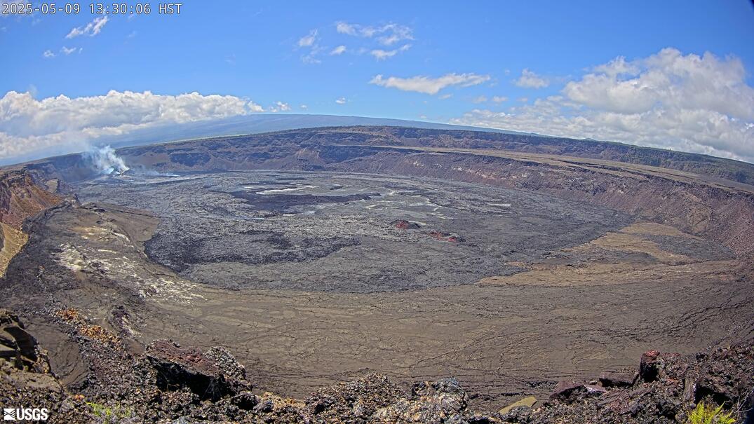
Next eruption the lava lake will grow beyond 1km above sea level. It has risen from 994 to 997m above sea level during E32. Three meters are like a strong storm surge in Dutch North Sea above Zuidwal volcano.
Its at that height where the laser is pointed, the vents are much higher already (+50m?) While the far east side is maybe a similar amount lower, although it may be alot more flat too.
Either way the vents are much taller than the number on that graph, the south vents that have just reactivated as I type this are a couple tens of meters above the north vent. Exact numbers for all of them are hard but likely close to 100m over the old surface, so maybe 1060m elevation.
It is a bit difficult, because the lava field is not horizontal, but grows upwards towards the lava shield of the cones. Can we estimate, how much the lava field expanded towards the east with the recent episode?
Counted from December 2024 the lava shield has probably grown to 100m above the prior base. I’d estimate that it is now ~50m below the caldera rim.
Full blown fountaining now.
Seems more voluminous than the ep. 31?
They had predicted that the eruption was going to start not before wednesday. So Kilauea/Pele surprised the HVO scientists. Maybe the overall high inflation on SDH shows that the eruption is very energetic now and episodes can develop relatively fast (compared to predictions).
South vent are active now, no good up close view yet but one is visible in the very bottom left of V3, low fountain but vigorous output. Its quite possible the whole structure that is fiverting the fountain is about to fail, and possibly with it the eruption will only have a single vent. If not this time in a couple weeks at E33.
Latest
EpicLava is live on facebook has a great view, although his commentary might not be to everyones tastes 🙂
From both the V3 and EpicLava streams it looks pretty clear the vents really are in the process of merging, the north vent fountain isnt as powerful as last time and theres a lot of lava erupting from the south vent, or the new ‘middle vent’.
To be honest it has looked like the actual original north/south vents have been dead or week for a while, the north vent big fountain has been blasting out of the south side of the north crater, and now a new vent appears between them.
When do you hazard a guess that the rock diverting the flow to the right will fail, and we’ll see the fountain coming straight up from the middle or south fountains? The leaking gas before episode 32 gave a strong hint as to the real conduit location. Sooner or later this diverting structure is going to fail.
Its only been going for 4.5 hours as I type this, but tilt has dropped 10 microradians. Its already about half over if it stops at about the point E31 did, though that isnt certain.
Also it implies an eruption rate of just over 2 microrads an hohr, which has been equal to about 2×750,000 m3 an hour though a little variable. But still about 1.5 million m3 an hour so far. Its quite likely to have a similar or even greater volume than E30/31 if ut does make it to 10 hpurs, although outlut will decrease over that time presumably so it wont be 15 million. My guess is about 9-10 million m3, making it the biggest episode of this year, and 2nd biggest overall.
In any case, output is very high. Its as high or higher than the average rate of big lava floods on the lower ERZ, or Mauna Loas 2022 average, or Holuhraun. Although its not in the league of the opening curtains of fire at Sundhnjukur, or especially Mauna Loa (over 40 million, per HOUR, is historical…) 🙂
It might also be likely that the peak pressure has already occurred, in which case the north fountain diversion has survived, barely. But if E33 is like this it might be on borrowed time. Either that or the middle vent might take over anyway, it grew a lot this time and wasnt there at all in E30.
Its exiting watching geology in real time. Easy to forget the entire topography in the V3 live cam is less than 10 years old.
Pelee unrest!
The V2 Cam right now shows significant outgassing. See https://www.youtube.com/watch?v=fiyttmA7YkA (11:49 am Hawaii time Tue 2nd Sept 2025) Does this mean that the true conduit location is this location, or that gas has found a way to seep further southward? I noticed this leakage about 4 weeks ago and wondered about it.
I forgot to mention the key detail, the outgassing is to the left in the picture and up the side of the caldera slope.
There is nearly 500 meters deep of lava in the caldera, most of that is molten still and it doesnt completely degas when it erupts. There were also many fumaroles in the 2018 caldera wall that are presumably still active too.
Its no exaggeration to say that if there was a vent under the lake itself, it would be obvious. Thats what most eruptions in the caldera 2020-2023 were. Its also unlikely there would be enough pressure to fountain either.
Was a response to Randall. But now you mention the upper slope instead of the lake, that is probably the thick tephra degassing. Happens at all big tephra cones.
A bit of Tenerife news today.
Tenerife volcano alert as tourists issued ‘potentially scary’ warning (Mirror, 2 Sep)
Having a rehearsal sounds like a good idea. And keeping an eye on what Mt Teide is doing sounds like a good idea too.
Something very unusual is happening for the episode 32 eruption. The attached photo is twice what I saw happen to the left hand side. Can anyone explain what is happening?. See https://drive.google.com/file/d/1inggrRi3Nz8udorjrn8t5kOEb7-oVZ61/view?usp=sharing. It appeared that the shelf on the left hand side activated.
Carefully watching the next 1/2 hour shows that what I caught is most likely a small tornado caused by the heat conditions in the crater area. The tornado picked up the dust and tephra and tossed it into the air.
Interesting, the eruption rate is lower than peak now but its looking like the actual limit of when the episode ends might be when SDH bottoms out, not UWD. Otherwise E32 would have stopped already…
Looks like the eruption has ended at Kīlauea.
The episode had a volume of 11.43 million m³. It has grown by around 10% compared to episode 31, and 100% (doubled) compared to the single episodes of June and July.
Yes, it was very voluminous, and as I predicted is the 2nd biggest episode of all 32 so far. E33 may well take 1st place.
My guess is that now the pressure is high enough that the main deeper magma chamber is a major part of this now. UWD fell 5 microrads too far with no real slowing until near the end. Tilt at SDH also better predicted the end too.
If this holds up, then the potential size of episodes probably has no practical limit, as the major chamber is probably 10x more voluminous than the Halemaumau chamber. Episodes migbt start getting to 10s of millions and weeks or months apart.
It doesn’t look like Kilauea is exhausted. The early date for the episode shows that the conduit is very open now for next magma waves. Anytime the magma is reloaded, the magma will shoot next episode without any blockage. During E32 there were no side vents, but on the main erupting shield appeared three vents that erupted together. The southern vent got a “sister vent”.
The rate of E32 was nearly 1 million cubic meters per hour or 277 cubic meters per second. That’s more than four times of the Themse flow rate.
Small eruption and elevated rate of uplift observed at Ioto.
Well, how timely my new article is. Let’s hope not too timely.
https://www.data.jma.go.jp/vois/data/report/monthly_v-act_doc/tokyo/25m09/202509021100_329.pdf
New post is up. The thing everyone loves and fears, a caldera!
https://www.volcanocafe.org/a-geomorphology-dive-into-caldera-systems-calderas-on-the-surface/