
Welcome to the Volcano Café bar, a place for all things on or off topic and inane ramblings. There has been a need of late to find a place better suited to various theories, long comments and enthusiasm. This page will be less moderated than the main article pages and cleared out every month (this may change depending on use).
Have fun and don’t forget to tip the barman 😉
Mauna Loa yesterday.
Interesting with the light, shadows, and frost?
Mac
Remember Bogoslof? This is what it looks like today.
A Pork chop?
Sort of makes you hungry…
heard You have bad weather as in tornadoes/ts etc… How are You?? Always check on the panhandle. 🙂 Best!motsfo
Astonishingly to me. Nothing.
Spent most of the day fretting tornadic activity in Mississippi and second guessing the weather channel and sending updates to one of my cousins there.
Was quite amused at two weather apps predicted a thunderstorms here at 23:00 and noted that not a thing on Nexrad could do it… so I went and grabbed a Reuben at a local sammich shop.
Ate my sammich, finished my beer and went to sleep.
Noted this morning that the festivities were past me and headed for Tallahassee. Let the dogs out, picked up my lawn chair and made grits.
Other than that. Nothing.
However, it did really mess some stuff up further inland.
glad to hear it. Best!motsfo
Kilauea lake with Planetlab satellite imaging
Carl Thank you for finding this kistufell link! https://academic.oup.com/petrology/article/43/2/345/1550472
Iceland plume is probaly just as hot as Hawaii
Around 1500 C deep down in the upper astenosphere
Vatnajökull arera is toasty as heck
Kistufell lavas erupted at 1240 C and was stoored
in a 1270 C crustal magma chamber.
Deeper down in the astenosphere its much hotter.
1240 C eruption temperature is really really hot
” Kistufell (64°48′N, 17°13′W), a monogenetic table mountain situated directly above the inferred locus of the
Iceland mantle plume. Kistufell is composed of the most primitive olivine tholeiitic glasses found in central Iceland (MgO 10·56 wt %, olivine Fo89·7). The glasses are interpreted as near-primary, high-degree plume melts derived from a heterogeneous mantle source. Mineral, glass and bulk-rock (glass + minerals) chemistry indicates a low average melting pressure (15 kbar), high initial crystallization pressures and temperatures (10–15 kbar and 1270°C), and eruption temperatures (1240°C) that are among the highest observed in Iceland. ”
Link. https://academic.oup.com/petrology/article/43/2/345/1550472
Mostly aimed at Albert, but any answers welcomed – conceived as a result of a question from the facebook group – I am now left wondering what makes ‘cryovolcanism’ count as ‘cryo’ and would water erupting (and forming ice) onto an icy area of earth count – how cold would it have to be – is there a definition ??
There isn’t a strong definition but it is defined as a type of volcanism that does not involve molten rock. ”Cryo’ means frost, and it typically describes a volcanic slurry – part liquid, part frozen. It should involve something that is an important part of the whatever the body is made of. Water on Earth hardly counts as it is a minute part of the crust. Otherwise you could describe any oil well as a volcano. Cryovolcanoes form on so-called ‘icy bodies’, which are for a large part made of water ice and other ices mixed in. Typical temperatures are below 200 K. They operate a bit different from Earth volcanoes, because liquid water tends not to rise up: it is denser than frozen water. You need to mix it with something. They can be explosive: the geysers of Enceladus (an icy body) count as cryo-volcanoes.
I know I seem contrary here 🙂
I know what cryovolcanism is (or at least I think I do) – but In my head I just substitute ‘water ice’ or ‘methane ice’ (or a mix or similar) for ‘solid rock’ and change the temperature scales and look at the liquidus/solidus boundary and constraining pressures. I think the liquid ‘cryo magma’ needs to have the option to erupt and become ‘cryo lava’ and ‘cryo tephra’ etc
So the problem I get (in my head) is trying to work out why I couldn’t call ‘solid rock’ something like ‘silica ice’ at some temperature range.
or perhaps why ‘frozen methane/water mix’ doesn’t count as some sort of ‘crystalline rock’ if we’re on a planet with a ‘room’ temperature of 200K
and then at what point do I say cryo volcanism does/doesn’t involve molten ‘rock’?
sorry for being a bit of a pedant – I’m just trying to get my head around a firm definition 🙂
I don’t think this ‘really’ counts – but I suppose if you took lake water as magma it sort of applies ! https://weather.com/news/trending/video/ice-volcanoes-erupting-on-lake-michigan
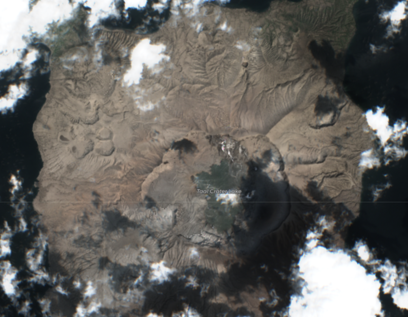
Nice new Sentinel image of Taal island
Hi Albert.
Here is a link showing 2 second animation of radar images of 2 regions of Venus, taken from Arecibo Telescope in 1988 and 2012, showing changes that have occurred.
https://twitter.com/ozone_aurora/status/1228057968383537153.
Have I spotted more evidence of recent volcanism?
Image link: https://airandspace.si.edu/multimedia-gallery/9776hjpg.
Do yo have another link to the gif? The twitter version doesn’t work well on my browser and twitter won’t let me download the original
I’m sorry this is the only ‘proper’ GIF link that I posted so far. I’m not sure if you use Facebook but I’ve posted the GIF on my page (4 posts down) if that’s any help.
(I extracted it from ‘https://airandspace.si.edu/multimedia-gallery/9776hjpg’ – there is a downloadable link below the image).
Maybe I could post the GIF or separate PNG files on here like you did for your other images above, but I’m not sure how to do this.
My link is “https://www.facebook.com/philip.evans.94”
https://www.medrxiv.org/content/10.1101/2020.02.07.20021154v1.full.pdf
OT
Delta celebrated profit sharing day by painting “Thank You” on one of its a321 planes. Thanking their customers and 90,000 employees that made it happen. The employees received an approx. 16% or around 2 months of wages of profit sharing (before the gov. gets its take).
The thank you is imaged using the names of all 90,000 employees, I wished my wife luck finding her’s.
disclosure, I am ex Delta and my wife is currently employed there.
“Delta Air Lines employees will have more than a billion dollars to keep them warm on Valentine’s Day.
The Atlanta-based airline is paying each of its 90,000 employees a profit-sharing bonus of about two months’ salary on Friday, Chief Executive Officer Ed Bastian said at a Cobb Chamber of Commerce event last month. The company-wide payout will total $1.6 billion.
This is not the first time Delta, which was ranked the No. 1 airline in the United States by the Wall Street Journal, has given its employees a big bonus. The carrier paid $1.3 billion in bonuses last year and $1.1 billion in each of the two years before that.”
https://www.foxbusiness.com/money/delta-profit-sharing-bonus-valentines-day
Now if I could figure out Pahala!
Happy VD day
Observations on swarm near Pahala
I have been looking at the activity near Pahala and had some observations. The overlays i have placed on Google earth are KML files from USGS and are the last 5 weeks of activity with magnitude 2+ in the area. The shallow range I choose was 25-34km and the deep was 35-50 km. The observation is that the deep quakes occur more often on the west side of the swarm and the shallow are east and getting shallower?. If you use the open street map on the HVO site you will also see a fault in the area.
I first thought that maybe different dikes or sills were feeding each system from different depths, gave up on that. Then I thought I could see a lot of moment of the swarm to the east. Then I looked at 5 weeks in June and July last year and there were quakes back then on the east most section of the swarm, gave up on that.
So it is back to being a swarm of quakes.
Pahala 5 weeks 35km or greater depth
Pahala 5 weeks 25-34km

5 weeks 20-50km

5 weeks June July 2019

Mac
Europe under full glacial conditions
30 000 years ago low CO2 levels
Extremely cold and extremely dry over all of Europe.
Much of Europe became frozen tundra
and all forests simply vanished in the dry cold climate.
In Northen Europe temperature was similar to Antartica winter. And much of central and east europe. was as cold as Siberia is today in winter in its coldest parts.
South Europe was hit very severely too with arctic conditions in winter reaching down into South Spain where mammoth and reindeer remains been found.
But the Saale glaciation before the Eemian was even more severe than LGM
I thought my frustrations with the columbian and ecuadorian geological surveys had peaked but Chiles- Cerro negro has seen a substantial increase of long period earthquakes and a deformation anomaly on the northern side of Chiles were the long period earthquakes are taking place. Just 2 teensy issues.
THEY DON’T EVEN TELL WHAT THE ANOMALY IS!!! IS IT UPLIFT?! SUBSIDENCE?! HORIZONTAL!? ONLY GOD KNOWS. I AM NOT ASKING FOR A DETAILED MODEL ON THE MAGMA CHAMBER OR SOME CRUSTAL THINGY!
tHIS JUST SHOWed uP RECENTLY aROUND SEPTEMBER 2019 AND AFTER ALMOST 6 MONTHS OF WAITING FOR A REPORT ON THIS ANOMALY i GET NOTHING!!!
Sorry to change subject. How does one post an image in VC? Thanks.
You need to put the image on a public website, and put the link to the image in the comment. No tags required. be sure to link to the image itself, and not a page that contains the image. The system decides whether to display the image directly or only the link – it depends on where the image is.
Ok, thanks 🙂
Hi Albert
What woud happen if the Hawaiian Hotspot ( a very very powerful hotspot ) was placed under the thick swedish craton?
Woud it melt through and forming a massive flood basalt when the trapped accumulated magma gets out?
Or is the 280 to 310 kilometer thick swedish craton simply too thick to melt through?
What woud happen if it was placed under Sweden and we waited a few million years?
IIRC, this is an actual ‘work in progress’ due to the Iceland hot-spot, which *seems* to have left a trace from Canadian High Arctic across Greenland etc etc, may be starting to affect the Skand craton…
IIRC, a growing swell from such has been suggested for why Northern Scotland seems to stand ½~~1 km higher than you’d expect from isostatic rebound.
Disclaimer: I’ve not seen any subsequent work on the topic.
That’s interesting. Do you have the source/link on this?
I also heard that there’s an unusually high mantle temperature (I think) under Norway, but can’t remember the source of this. However, I think it’s more due to possible embryonic subduction rather than the hotspot.
I think there’s an unusually high mantle temperature off the N coast of Scotland, to what I remember.
Hard to tell. In a way the Deccan spot did this. The Afar spot is probably the best example where it split a very thick plate. The Siberian spot went for the thinner crust next to the craton but didn’t split the continent. The Deccan spot went for the edge of the plate – not sure how tick it was there, it also did not split the continent. Magma will always go for the weakest spot. Put it under Sweden and it will try to go for Denmark. You will get a 2 km bulge on the plate, similar to Yellowstone. The flood basalt may not come out at the tip of the bulge but like Holuhraun, find a way to the surrounding region.
Possible flank-collapse developing on Tungurahua volcano in Ecuador ?
https://phys.org/news/2020-02-south-american-volcano-early-potential.html
Fair-use quote:
One of South America’s most prominent volcanoes is producing early warning signals of a potential collapse, new research has shown.
Tungurahua volcano in Ecuador—known locally as “The Black Giant”—is displaying the hallmarks of flank instability, which could result in a colossal landslide … on the western flank.
…
A previous eruption of Tungurahua, around 3,000 years ago, caused a prior, partial collapse of the west flank of the volcanic cone.
This collapse led to a wide-spread debris avalanche of moving rock, soil, snow and water that covered 80 square kilometres…
/
Down-side, that ~3 kyr BP event was nasty. Upside, it did not trigger a Mt St Helens lateral blast. May not be so lucky this time…
Um, which of the Med volcanoes exhibit significant flank creep ? Also, is the Hawaii Big Crack still active ??
I wish that articles was from the IGEPN…a lateral blast could threaten tens of thousands of people and it took an outside party to either make this knowledge public or to even find out this is a significant risk.
In the Mediterranean there are probably many volcanoes that can undergo flank failure but Etna stands out, its entire flank is moving seaward over normal faults and does slow-slip events from time to time, if it collapsed it would be massive but of course it is very very unlikely. Stromboli has seen a couple of flank collapses during the Holocene so it might be a better candidate.
The Big Crack is not moving, I am not sure right now if it was opened by the Great Kau earthquake of 1868 or by a dike intrusion in 1823, I think I have read both versions, in any case it is unlikely to be related to gravity instabilty but rather to magmatic activity in the SWRZ of Kilauea which runs below.
Now the IGEPN states that there is no risk for flank collapse…
https://www.igepn.edu.ec/servicios/noticias/1800-aclaracion-a-la-comunidad-volcan-tungurahua
Who is right? And how did this happen in the first place.
I guess the journal saw the title as a request, and happily implemented it.
Thanks Albert
Is that really what woud happen IF Hawaiian Hotspot was placed under sweden craton?
Hawaii is an extremely powerful hotspot in melt-rates and thermal input.
Hawaiian oceanic litosphere is 100 kilometers thick. Sweden craton is 290 to 320 km thick,
so its really thick
Enormous magma accumulation under souch trapping thick litosphere?
Melt rates in Hawaiian Hotspot is many many km3 every decade that gets pushed towards the litosphere base.
Denmark woud be for a really bad flood basalt?
The Hawaii hot spot has not caused a full flood basalt recently. It may have when it first formed. The yellow spot did a flood basalt in Columbia but not since. I think hot spots tend to do only one flood basalt, after which they calm down to something more sedate – like Iceland or Hawaii. So Denmark might be ok. But put a proper plume under Sweden and all bets are off. You do need permission from Carl.
When the Hawaiian Hotspot first surfaced 70 to 80 million years ago, it may have formed an enormous oceanic flood basalt.
That oceanic LIP have long since been subducted in the Russian trench.
If Hawaiian Hotspot was located under Sahara Desert that moves very very slowly over the hotspot.. we woud get a lava pile higher than Olympus mons on Earth
I meant bigger … more massive
Not higher
Hawaii haves an immense output
Combine that with a very slow moving plate above
IIRC, there is a sorta-hotspot driving the Tibesti massif and its suite of volcanic centres. Lava seems to have been ‘too runny’ for really tall cones, it just spread out…
Which is a shame, as fewer, taller cones would likely be cloud-capped, generate a much more benign micro-climate.
As I understand it, there is scant modern ‘field work’ on the massif, remote sensing being significantly more survivable…
That aside, the Tibesti massif is a very strange beast, its existence perhaps related to both an Atlantic opening’s aulacogen, striking North from Niger rifting, and the wriggly push-me-pull-you of Africa vs Europe…
Ha ! Thought I’d remembered a couple of wondrous VC articles on this topic…
https://www.volcanocafe.org/the-forgotten-volcanoes-of-chad-part-i/
https://www.volcanocafe.org/the-forgotten-volcanoes-of-chad-part-ii/
😉
I wonder if Kimberlite Pipe type volcanoes (i.e., Volcanic Pipe) are also what happens when the hotspot is under a craton.
They have unusually deep magma source and produce violent eruption if rich in gases (e.g., if carbonate rocks are heated by magma). They can also bring diamonds to the surface. They are common in Africa, NE Canada and Siberia.
Kimberlite Pipes are fascinating volcanoes but yet there’s much less literature on these on the Web
compared to ordinary volcanoes. I really love to know more about these; when they last erupted and when the next one will occur. Love to see one in action! (Probably look like Taal 2020 or Grímsvötn 2011).
The most recent kimberlite was in the Igwise hills
https://www.volcanocafe.org/diamond/
Hi Folks. I thought I’d try this link again if this is Ok, but not sure if it will work.
This is 2 second animation of radar images of 2 regions of Venus, taken from Arecibo Telescope in 1988 and 2012, showing changes that have occurred.
Have I spotted more evidence of recent volcanism?
Hi Folks. Have I spotted signs of volcanic activity?
Hi Admin. My new comments are not appearing here. Could you look into this, please. Thanks.
Comments found in the spam bin. That is the oublier below the dungeon – I don’t know what you did to end up there! Comments released.
Thanks Albert. Sorry for the problems.
It may be due to this link here;
I loaded it on pinterest as the twitter version did not work.
So far it worked 🙂
According to the HVO / USGS Mauna Loa has inflated by ~40 cm since mid March 2019.
“These signals show that magma is entering the shallow storage system”, which they have been saying all along, but now we can see it as nice interferogram fringes…
Of course, the Pu‘u ‘Ō‘ō inflation of ~17 cm (at (C)) is also not gone unnoticed…
Where does the 40 cm figure come from? I think HVO increased by n order of magnitude the actual value. Uplift at the station MLSP (which is at the inflation center) for the 10 month period is 4 cm.
When starting to count fringes from the pink area at Mauna Ulu, where the first GPS to show some slight inflation is located, looks like the area east of Pu’u’o’o has moved up by 23 cm, which is similar to what JCUZ (closest to the inflation center) shows.
Hard to say but the east of Halema’uma’u area (B) appears to have inflated by at least 14 cm.
It came from here: https://volcanoes.usgs.gov/volcanoes/kilauea/multimedia_chronology.html
“Data from the European Space Agency (ESA) Sentinel-1A and Sentinel-1B satellites on March 31, 2019, and January 31, 2020, produced this interferogram. Each fringe, or band of colors, represents 2.83 cm (1.1 inches) of range change—the distance between the satellite and the ground. Counting fringes gives the total range change between two satellite passes. At point (A) the ground moved closer to the satellite by 7 cm (2.75 in) between the two passes due to inflation of the shallow magma chamber beneath Mauna Loa’s summit. The angle at which the satellites viewed the ground shifted the signal slightly east of the summit. Fringes near point (B) at the summit of Kīlauea reflect inflation of the shallow Halema‘uma‘u magma chamber. This inflation has been observed since mid-March 2019, with a total range change of approximately 40 cm (15.7 in). Point (C) is on the middle East Rift Zone near Pu‘u ‘Ō‘ō. Interferograms and GPS data show that inflation has slowly shifted toward Pu‘u ‘Ō‘ō in recent months, during which the range change has been about 17 cm (6.7 in).”
So 40 cm was at the summit of Kilauea. 40 cm in 10 months is spectacular, I think it is the highest long-term inflation rate I have ever heard of, since the fringes were so close together at the summit it was hard to count them, I had counted at least 5 but it seems I had underestimated it.
Both Mauna Loa and Kilauea has stopped inflating quite as fast as before. They haven’t stopped entirely but since December there has not been much gain in either volcano.
So it seems, when the resupply from the Pahala area gets to the volcanoes it might make things interesting again, not sure how long will that take though.
I interpret the initial inflation of Kilauea as due to the collapse of the caldera. There was less weight of the rock, so lower pressure below. This lower pressure sucked in magma from the surrounding region. That surrounding magma now needs replenishing from either below or from Pahala, and perhaps some local melt. My bet is that the next step will come from Mauna Loa. But I wouldn’t put money on that.
Hi Folks. Does anyone have any ideas if the changes seen on Venus radar image I recently posted are anything to do with volcanism? Thanks. 🙂
Hard to tell! Something may have changed. Here is a higher resolution radar image of Gula Mons. It is an active volcanic region. But the area you found may be just outside it. I am less convinced by the other area because the stripe moved as well. That suggests that a different illumination angle may have contributed.
Thanks Albert. Agree with you.
It does certainly look like a lava flow on Gula Mons, and, as you’ve said, it’s an active volcanic area. The other one looks more like an illumination artifact.
Unfortunately. the resolution is very low. There ought to have been another radar survey from a space probe (say Magellan II) to detect what changes may have occurred.
This is how to solve the problem of sea level rise.
https://journals.ametsoc.org/doi/pdf/10.1175/BAMS-D-19-0145.1
Earthquake list on HVO’s site and USGS latest quakes have stopped reporting quakes. I see a min of one that should have been reported, if it is a real quake at 20:29 UTC?
Mac
It’s working again now.
http://hraun.vedur.is/ja/vatnajokulsvoktun/grf_uppsafn.html
Looks like Grimsvötn is about to erupt in the near future.
Magma pressure is increasing and stressing the bedrock walls in upper magma chamber
I hope it crushes the northern hemisphere.
Here’s an article on Space.com. It says there’s more water on Jupiter than anyone thought.
https://www.msn.com/en-us/news/technology/surprise-theres-more-water-on-jupiter-than-anyone-thought/ar-BB10hzaH?ocid=spartandhp
Just read that. Very interesting. Galileo just happen to be unlucky enough to dive down into a dry region.
Jupiter has very immense internal heating, much more than for Earth. However, instead of fuelling volcanism, it fuels Meteorological activity, producing revolving storms and massive cumulonimbus clouds, latter producing numerous thunderstorms.
I wonder if the Great Red Spot is generated from deep within it’s interior.
Some Jupiter cumulonimbus clouds are 70 km high and casts long shadows on the clouds below.
Once they hit the tropospause they flatten out.
Jupiter anvils grow 7 times higher than earths and 10 times wider.
Late sunsets on the giant anvils must be spectacular! The rest of the cloud sea is in darkness. But the high anvils illuminated pink since they are higher and still lit by the sun.
I wants a probe sent down into Jupiter with a camera on: woud be fun to see the clouds and do new instruments.
Do iron and sillicate clouds exist deeper down in Jupiter? deep under the ammonia and water clouds?
If Jupiters haves enough heavy sillicate elements in the Hydrogen mix they may condense low in the atmosphere?
Albert: Any iron rain in Jupiters deeper hotter layers?
Of course Jupiter is mostly hydrogen
https://astronomynow.com/2019/08/17/a-core-warping-impact-in-jupiters-past/
Since it is a little quiet at this bar… can someone tell me what this image means? I think it went over my head.

An intereferogram can be affected by the topography (I think that was due to atmospheric effects), most of the changes seemingly follow the topography which would indicate that this is the case.
If there was a volcano inflating within the image there would be a bullseye pattern with the deformation centered in a particular point.
The intereforogram covers a very short period though, just several days, that is probably not enough for volcanic deformation to show up even if it is there.
Nothing significant, I am afraid. Clues: lack of a clear pattern, each of the three show different structures even though they use the same data (in part), and the amplitude of +-1cm is around the accuracy level. Possible causes: in such complex terrain the angle of the line of sight can make a lot of difference, the calibration positions (not shown: they will be somewhere outside the depicted area) have uncertainties, and variable water vapour can in cases cause some variations.
Where is this, sorry to ask?
Chiles cerro negro. Unfortunately this is the only insar data I could find and it shows nothing.
What KT impact may have been like for the dinosaurs.
From the book that came with the
infamous BBC s Walking With Dinosaurs tv series.
”Just as the T Rex hatchings are tearing at their dead mother’s flesh, a very bright light appears on the horizon to the south. It grows quickly in intensity as the tyrannosaurus chicks look up in curiosity,
the light grows more intense. They return to their mother’s carcass. Chicxulub Impactor, some 6 miles wide in diameter and traveling at 30 km per second, just hit a shallow sea around 2,000 miles away to the south. The distant glow is an explosion of about 200 million megatons, The Asteorid and Earths local crust are vaporized and sent on ballistic reentry.
The light from the impact fade in total silence.
For a few minutes the young Tyrannosaurus continue to eat mother’s carcass unbothered. The glow starts to decrease, but a glowing plume is growing in the sky from the south. Suddenly, the ground begins to shake.
The two chicks look up quickly, then crouch down in fear. Sweeping across the floodplains and marshes, a hurricane-like shockwave slams into the valley forest.
Worse than any hurricane, massive 40 m Araucaria are snapped like matchsticks.
The young Tyrannosaurus are sucked from their mother and thrown into a maelstrom of flying rocks, twigs, wood and leaves. For a moment, the wind drops, but then it returns, tearing at the land in the opposite direction. The forest is devastated, but the worst is yet to come. While the huge darkening plume grows larger and larger, temperatures begin to rise. Hot rocks rains down and spontaneous fires start up among the piles of debris.
The temperatures continue to climb and the Animals that survived the shockwave now burst into flames alive.
The giant plume of debris from the explosion blocks out the sun. While the ejecta darkness descends, countless tiny balls of molten rock rain down from the sky, bringing death in their wake. Over the entire landscape, anything that can burn ignites. Finally, the noise of the impact hits the arera, a deafening split in the atmosphere.
Twisted and crushed between two huge flaming Araucaria lies the burnt boiled chared mother Tyrannosaurus, her neck thrown back and her mouth gaping open. The molten rock rain gradually burns the flesh from her face, exposing her teeth.
Her long struggle to reproduce has come to nothing. Most life in America is over.
The superhot vaporized rock from the impact spreads out like a deadly fan across the Mesozoic Earth, signaling the end of an era. By blocking out the sun, this deadly blanket throws the world into an unnatural winter, and Animals and Plants die in the billions. Eventually, the skies clear, but It takes the ailing Earth millions of years to recover, but the forests return and Ferns spread once again. The most notable Thats gone from this fresh green world are the giant dinosaurs.”
I would think the thermal shock from the fireball being visible would do considerable injury. At 200 km, radiant flux is between 200 to 2000 times that of the sun. No critters bursting into flame, but 3rd degree burns for sure.
https://impact.ese.ic.ac.uk/ImpactEarth/cgi-bin/crater.cgi?dist=200&distanceUnits=1&diam=6&diameterUnits=4&pdens=&pdens_select=3000&vel=17&velocityUnits=1&theta=45&tdens=1000&wdepth=500&wdepthUnits=1
12 to 15 to kilometers in diameter for the asteorid is probaly more correct.
And… 30 kilometers per second
In the book this scene is 3000 kilometers from the impact.
The fireball flash wont be visible at that distance
But all the ejecta and vaporized rock, will reenter the atmopshere, basicaly forming a firestorm in the skies above when they reenter
Re – entering ejecta heated up large parts of the planet
Your dinosaur commentary is cracking me up. Surrealism at its finest.
I was wondering why no-one was commenting on the Edinburgh post and now I’ve found out why – you’re all here! It’s a shame because I’m not sure casual visitors would find their way to the bar …..
Indeed. They took the positive vibes in the post about Edinburgh pubs a bit too much to heart..
BBC s 1999 s Walking with dinosaurs TV seriers is a legend…
all 6 episodes legendary and Benjamin Bartlett did an amazing work with the score.
Walking with dinosaurs is my childhood
Whole TV seriers can be found here all episodes
episode 1 https://www.dailymotion.com/video/x2n72dd
episode 2 https://www.dailymotion.com/video/x6cif36
episode 3 https://www.dailymotion.com/video/x5ip9ui
episode 4 https://www.dailymotion.com/video/x6cif3u
episode 5 https://www.dailymotion.com/video/x6cif3v
episode 6 https://www.dailymotion.com/video/x3moziw
A review of Walking with dinosaurs episodes can be found here: https://www.youtube.com/watch?v=g8lWUN4X1mc&t=934s
The last episode is set in late cretaceous weeks before the meteor impact.
The whole atmopshere is of doom and the feel sickening.
These are the first dinosaur documentaries in all history to show them as real animals in a nature documentary. The filiming locations and the cgi is very good combined with excellent atmosphere
I don’t know if this is true(Mainly because it isn’t really studied) Cerro Machin, Santa Rosa, Cerro Bravo, Santa Isabel have all been showing increased activity. This study says they all share a common source that is being disturbed. https://www.sciencedirect.com/science/article/abs/pii/S0377027316301299
Scary, and then this study says one MASSIVE reservoir might actually be feeding all these volcanoes at the modest depth 20-30 km. https://www.sciencedirect.com/science/article/abs/pii/S0377027317305942 or if you want the full study.
https://kundoc.com/queue/pdf-overview-and-plumbing-system-implications-of-monogenetic-volcanism-in-the-northe.html
Hi Albert I haves a question
Did modern megathermal Broadleaf wet red hardwood tropical rainforests exist during the very latest cretaceous?
By early paleocene large parts of the world, was already covered by modern tropical forests…
During paleocene and eocene, modern Broadleaf wet red hardwood tropical rainforests
grew on every continent in the heat and humidty.
The most early fully developed modern Tropical broadleaf forests are 62 million years old from colorado.
Did modern megathermal Broadleaf wet hardwood tropical rainforests exist during the very very
latest cretaceous?
Where is the origin of the modern broadleaf anigosperm rainforest?
No fossil clues older than early paleocene
Hey what is this deformation? I can just tell that there is some but not what type it is.

Rapid deflation at the summit of Agung. It looks like the crater has gone down by 5-10 cm. Everything else on the map is noise but that deflation is real. Seems too fast for cooling of the lava in the crater, so magma pressure must be decreasing.
Just so that I won’t have to ask this question again. How does one properly read those images with no context?
On a another note if the crater has lowered that much in 12 days, that is some fast depressurization if that’s true but everything is so quiet on top. Could there be any other causes for subsidence.
First look for the order of the colours and compare to the colour band at the bottom. That shows where things move up and where down. In your image it is actually very hard to see because the colours are too close together in the crater. Now look to see where the same sequence repeats, so you have clear inflation/deflation pattern. You show three images: check whether they show the same pattern or not, or even reverses. In the latter case you are looking at noise. In your image, only the crater passes these tests. Also note that you are using a very short timeline. Typically, you need months to see clear volcanic patterns. Where did you find the image?
https://comet.nerc.ac.uk/volcanoes
Right here.
Some news from the moon
“A little over a year after landing, China’s spacecraft Chang’E-4 is continuing to unveil secrets from the far side of the Moon. The latest study, published on February 26, 2020, in Science Advances, reveals what lurks below the surface.”
https://scitechdaily.com/lunar-rover-reveals-what-lurks-40-meters-below-surface-on-far-side-of-the-moon/?
3.7 at 5km on the Big Island. Earthquake reporting is temp down. They also had a 2.9 at -1.9km at Mauna loa summit area.
HVO now has the 3.7 at -1.5m. Just looking at google earth that area is around 5500 feet in elevation, so the quake was only 1000 feet deep.
Freeman Dyson has died. He was the person who provided the ideas for many areas of today’s physics. Project Orion was his baby, and he also invented the implausible Dyson sphere. According to infallible wikipedia, he tried to calculate the number of atoms in the sun – when he was four.
”Tyrannosaurus would have a repulsive look:
A dark body, a Red head, and it gives off a terrible smell. This would help it frighten away other meateaters,
like dromaeosaurs, from carcasses.
T rex is “big, nasty, and stinky.” Really narly, and gross looking head features to scare away others from carcasses”
Thats Jack Horners view of T – Rex
T – Rex as a pure scavenger is a view thats not shared by most paleontologists
What did Sweden look like during the PETM?
The ice age have removed all 50 million years old sediments
I think I found some uplifting volcanoes 2 this time

https://gqzvi1nt5j82vl48b1568uq1-wpengine.netdna-ssl.com/wp-content/uploads/figures_sentinel/nevado_del_huila/nevado-del-huila_142D_08745_13
Something very strange this morning: the sky has an unusual colour. It is blue. We haven’t seen that for several weeks.
Here in Ga we finished Feb. in second place for the most rainfall in the month. We are now looking at 2-4 more inches next week. Not good for getting the soccer club on the fields.
UK reporting totally wettest Feb on official record, with a short weather window before jet-stream tries to repeat for March.
Forecasters saying ‘century’ events have become ‘sub-decadal’, with more to come.
Upside, it is rain, not snow which, given a foot of snow per inch of rain, would have been nigh-apocalyptic. Yeah, I remember having to clear our path every day after school, and digging out trash-bins from their drifts. And, yes, I marked where our near-by street drains were, so I could poke out their grids’ ice-dams with a dutch hoe. Splendid gurgles ensued, plus we could cross road in shoes rather than wellies…
The recurring floods are horrible, horrible, and their short repeat time means a lot of folk will be ruined. Happily, my district sits atop a sandstone ridge with the reassuring Medieval dry-foot suffix ‘On The Hill’. Lonnnng term, given worst-case sea-level rise, we’d become a peninsula, almost surrounded by wet-land & salt-marsh…
Hours after chicxulub Impact… the sea began to resourge into the searingly hot crater
The sea resourge in the crater must have been amazing…atlantic sea violently flows over the newly formed crater floor… thats been 3 times hotter than surface of the sun.
Some geologists thanks that that 200 km wide superhot then quickly drenced spot… shortly after the impact… boiled the local ocean forming hyper hurricanes.
Amazing steam explosions during the re – sourge of the atlantic over that searingly hot surface
A little math this morning. We are expecting rain next week in the Southeastern USA. Both the GFS and the ICON global weather models are predicting 2+ inches of rain over the states of Miss., Alabama, Georgia and South Carolina from Monday – Thursday.
Land area in square miles.
Ga.59,425
AL. 52,419
Ms 48,430
Sc. 32, 020
Total land area for 4 states
192, 294 square miles.
Take a guess on the amount of rain in Gallons before you look below!
I went to this website to get the amount water for 2 inches of rain over 1 square mile.
https://water.usgs.gov/edu/activity-howmuchrain.php
Gallons of water on 1 square mile.
34,757,120
cubiic feet on 1 Square mile
4,646,679
For the 4 states combined
Gallons
6,683,585,633,280
Cubic feet
893,528,491,626
That is a lot of energy to evaporate and transport the water. If we could monetize it we could start paying off our federal debt.
Our 9.5 acres 515,926 gallons.
Back to regular programming
Volcanoes where they shouldn’t be? Maybe it’s a mantle sponge
https://arstechnica.com/science/2020/02/volcanoes-where-they-shouldnt-be-maybe-its-a-mantle-sponge/
Western Interior Seaway was the stuff of nightmares.
I woud not even dare to walk in shallow water in that seaway!. The western interior seaway was the most dangerous ocean EVER. The most dangerous predators in the most dangerous ocean ever. Nowherelse in the world is the fossil density of large predators so high as there are there. Cretaceous era is often called ”hells aquarium” because of the sheer diversity of large marine predators that populated the oceans. Giant Mosasaurs of many diffrent species, giant plesiosaurs, giant sharks specialy the ginzu shark, huge agressive squids, sharks, stingrays of all kinds and very large toothy fishes.
Everything in the ocean back then, was very toothy and built , evolved to killing things.
Lots of predators monopolizing on same resources
Agreed. Then kilometres of sediment accumulated in what’s now the Mississippi watershed, throwing stress on Reelfoot and related rifts…
Um, was the Interior Seaway related to Mississippi aulacogen derived from North Atlantic’s erratic opening ??
FWIW, I came across a mention of a ‘Pleistocene Sea’ that took in current ‘Great Lakes’ via St Lawrence rift. Given Niagara, Looks like an artifact of isostasis. But the term may be too local for google which, instead, regaled me with fascinating reports of SE Asia & Sundaland shore-lines, grounded ice in UK’s North Sea etc etc…
I knew of the vast glacial lakes, those bad-land mega-outflows etc, I knew one ice-tongue blocked Eastward drainage from Great Lakes area. A high-stand ‘Pleistocene Sea’ is new to me. Is there a good reference or ‘finder’ term ??
HVO is reporting sub 1 magnitude quakes on Mauna Loa in the area of the new outbreak east and a little north of the summit. This is an area in between the GPS stations PUKA and MLPR. Both of the recent quakes look rather normal to me, but then what do I know! There have been around 23 quakes since the 3.0 at -.4km on 3/3. Maybe something interesting going on.
There have been 58 quakes since a 2.9 at 5.8 woke the area up.
2020-03-01 07:07:33 2.9 0.7
2020-02-28 14:09:13 1 2.6
2020-02-20 22:19:13 2.4 -2.4
2020-02-15 17:35:12 2.9 5.8
Seems a bit of slipping down-hill. The GPS Monitoring Station MLPR below it showed a sudden drop around the first quake from which it has now recovered. My guess is that this quake was registered as M1, and was kept when it was downgraded to an 0.9!
It is an area of known strike slip faults so yes probably just some slipping.
Short lived (7 min), but not weak, deep tremor in Hawaii originating from the Pahala area. From 14:42 to 14:49 UTC.
M 2.4 – 9km SSE of Pahala, Hawaii – Depth 41.9 km
Good catch
Lava tubes & Caves…
Could any-one point me to a good resource ? My google-fu has come up short…
—
As I understand it, you need ‘seriously runny’ lava to form such, as sustained flow must finally drain away to leave void.
Which, I reckon, limits locations to shield volcanoes or flank eruptions of ‘stratos’.
Given I’d like to set one on an exo-planet with ~0.8 g gravity, would it be fair to say lava needs to be runnier, the slope steeper ??
This should interest you then:
https://www.lpi.usra.edu/decadal/leag/AndrewWDagaFINAL.pdf
There seem to be lava tubes in Mars and the Moon, and in terrain that is relatively flat, so regular basalt will probably do.
Well, that’s one way to shift the R0…
https://www.dailymail.co.uk/news/article-8086077/Hotel-China-holding-coronavirus-victims-quarantine-collapses.html