
This is the second instalment of the Dawn space trilogy. If you haven’t seen the first part yet, you may want to read that first.
A quarry into an overturned megablock at Nordlingen. Source http://www.impact-structures.com/impact-germany/the-ries-impact-structure-germany/outcrops/
The region was known to be peculiar. The ground around the German town of Nordlingen contained strange rocks – the houses were build from them. Geologists had decided that it had been the site of a massive volcano. But in the 1960’s, doubts crept in. Eugene Shoemaker first called it an impact crater. It took decades before that view became accepted, with dissenting papers being published as late as this century. In the end the evidence became indisputable. The wealthy heart of Europe has been hiding, unrecognized, the largest impact crater west of the Volga (the Puchezh-Katunki crater just east of the Volga is larger). The Nordlinger Ries, as it is now known, is 26 kilometers across with a rim 200 meters high. The interior is flat: there is no central rise, probably because the impact made the interior melt. Over the years, much of the rim has been quarried. The quarries are now a geology park: they reveal the geology nice and obvious. One thing they show is the sheer violence of the impact. One of the quarries mined an overturned block, with all the strata still in place but inverted. The block is a cubic kilometer in size and was thrown over a distance of at least 7 kilometers! The ejecta of the impact blanketed the ground 50 kilometers away.

Nordlingen, Southern Germany. The town is build in and from an impact crater. The rock used is embedded with micro-diamonds which formed in the shock of the impact, each a fraction of a mm across. The builders never knew!
The impactor that created the crater is estimated at 1.5 kilometer in size. Interestingly, this is about the size of the red-roofed, walled town of Nordlingen itself. The impactor was a stony asteroid which had been ejected from the asteroid belt, probably by the gravity of Jupiter, into an orbit that intersected that of the Earth. Each time the orbits crossed, the Earth wasn’t there. But finally, after perhaps a billion years and hundreds of millions of misses, luck ran out 15 million years ago. The asteroid tried to pass, but this time the rim of the Earth was in the way and an impact became unavoidable. The Nordlingen impact must have shaken all of Europe. And it didn’t come alone. It turned out that the asteroid had a small moon, 150 meters across. That too hit the Earth, and caused a crater 42 kilometers away, towards Stuttgart: this formed the 4-kilometer wide Steinheimer Basin. Further east, the moldavite fields of Bohemia and Lower Austria were formed during the same double impact event.

From Ries crater and suevite revisited, Stoffler et al, Meteoritics & Planetary Science 48, Nr 4, 515–589 (2013)
The impactor that formed the Riess crater is classified as an achondrite. This is an obscure type of meteorite, which consists of basaltic (or plutonic) rock. Chondrites are meteorites that still contain the nodules from which they first formed, in space. Achondrites do not have that: they were metamorphosed. No space rock should do that. To get basalt, you need to melt rock and let the molten mass come up. That requires a reasonable large body, otherwise there is not enough heat to cause melt. It must have well over 100 kilometer across. About 8% of asteroid impacts are by achondrites.
Meteorites can sometimes be traced back to their origin. A big impact can dislodge rocks with such violence that even on a small planet, some fragments can reach escape velocity. Several meteorites are known to have come from Mars. One of them famously was claimed to show evidence for past life on Mars. (That evidence is not currently accepted.) Quite a few meteorites are known to come from the Moon. Meteorite hunters/scientists may spend the summer on the Antarctic icecap to search for them: the dark colour makes them stand out against the white ice. This allows us to study the composition of objects we can not (or can no longer) reach directly. NASA, though, prefers to collect its evidence in situ rather than second-hand from Earth.
Two thirds of the known achrondrites (5% of all meteorites on Earth) have orbits that are similar to each other: They seem to be debris from the same original asteroid. The orbits point at Vesta as the origin, and that is now commonly accepted. The Vestan achondrites form three distinct families, called the howardites, the eucrites and the diogenites. Together they are called, with all the imagery the scientific language can muster, the HEDs. There are quite a number of such asteroid families, where objects have orbits that indicate a shared origin. Most members of a family look identical, with the same colour and composition. This is not the case for the HEDs, where each of the three related families show distinctive colours and composition. Eucrites are basaltic, effectively solidified lava. Diogenites are solidified magma (plutonic), i.e. which cooled slowly underground allowing crystals to form. Howardites are intermediate, with aspects of the two. If all three came from the same body (Vesta), that body has some interesting geology – and that includes volcanic activity. It is worth a close look.
(It should be noted that the classification of the Ries impactor as an achondrite is based on fairly flimsy evidence, and other classifications have been proposed. If it is indeed achondrite, it may still have been from another source than Vesta, in common with 1/3rd of the achondrites. So this association should be taken with some care. Still, Nordlingen is the best case we have for a crater from Vesta.)

The Steinheimer crater
Vesta by Dawn
We knew quite a bit about Vesta even before the Dawn space probe came to visit. In common with all but one of the asteroids Vesta is distinctly not round. (Only Ceres is round.) Vesta has a size of 573 km along the equator but only 446 km between the poles. The shape has been compared to a giant walnut. Vesta is a fast rotator, with a period of 5.3 hours. The density is 3500 kg/m3, higher than that of pure rock, and much higher than ice. This density already shows that Vesta is a rocky body, with a significant amount of metal (iron) thrown in to bring the average density up. This composition is similar to that of the terrestrial planets, and very different from the icy moons of the outer solar system. Vesta clearly belongs to the inner solar system. The location also says so: it is orbiting near the inner edge of the main asteroid belt, much closer to Mars than Jupiter. But it is not a planet, not even a dwarf planet. It missed out because it lacks roundness. It has too much character.

Dawn arrived at Vesta in mid 2011 and spend just over a year exploring the world, finally escaping back into space in September 2012. The exploration was mainly divided between two orbits, one at 700 km above the surface and one at 200 km. The images showed more details of the shape. In the southern hemisphere of Vesta, even from a considerable distance it revealed two large, overlapping depressions. Both are circular and appear consistent with impact craters. The largest of the two had already been seen by the Hubble Space Telescope, and is now called Rheasilvia. It is an impressive crater by any standard, but especially so on the small body of Vesta. Rheasilvia has a diameter of 500 km, equal to 1/6th of the circumference of Vesta! The rim is as much as 19 kilometer above the crater floor. The biggest surprise was the central peak, discovered by Dawn. It is a staggering 200 kilometers across, and 22 kilometer tall; it is one of of the tallest mountains in the solar system. And Dawn found a second crater, partially obliterated by Rheasilvia. This is called Veneneia, is 400 kilometer across, and 12 kilometer deep. From crater counts inside the basin, Rheasilvia is estimated to be 1 billion years old. Veneneia is probably twice as old. At Vesta, lightning did strike in the same place twice.

Rheasilvia with its central mountain. Click on the image for a lot of resolution
The Rheasilvia impact excavated 1% of Vesta’s mass. This impact is the most likely source of the HED meteorites, and perhaps led to the double impact in Germany, 15 million years ago. This would mean that 5% of all current meteorite impacts on Earth can be traced back to a single event in the solar system, 200 million kilometers away and a billion years ago!
The movie below was made by stitching together lots of separate images from Dawn, taken over an extended period. Rheasilvia is visible at the bottom. The profile shows how much of Vesta is missing because of the crater: the walnut shape is in part because of the missing south. The central mountain, Rheasilvia Mons, is a notable bump in the profile.
Dawn found another peculiar feature: a set of grooves stretching out around the equator. We do not know how they formed but the structures are similar to grabens on Earth. And they are huge. The largest one, Divalia Fossa, is 465 kilometers long, 22 km wide and 5 km deep, and comfortably dwarfs the Grand Canyon. There are in fact two sets of grooves, with slightly different orientations. The clearest ones are equatorial, and centred on Rheasilvia: these appear related to that impact. The second set is less clear and appears older: they are centred on Veneneia.

Equatorial (white) and northern (red) troughs on Vesta. The center positions of the trough sets correspond to the center of Rheasilvia (white ×) and Veneneia (red ×), respectively. From Jaumann et al. (2012, Science 336, 687–690).
A graben signals a local extension of the crust: there is not enough crust available for the extension, and holes develop in which the top layer drops down. Imagine what would happen to your roof if the walls of your house would move a little further apart. It is not immediately clear though how a major impact can cause extension. Perhaps the shock of the impact could have pushed the equator outward. It has also been suggested that the impact caused Vesta to rotate faster, and thereby develop an equatorial bulge.
At least 10 other craters are more than 50 kilometers in diameter. The largest of these is 250 km across, and is also partly covered by Rheasilvia. Most of the craters are in the northern hemisphere, where the oldest surface is found. This old surface was obliterated in the south by the two large impacts. Note that the north pole is not covered by the images. Dawn was in orbit only during the southern summer – the north pole was in perpetual darkness. So there could still be more surprises waiting.
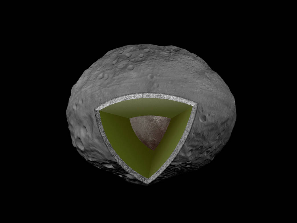
Structure
Dawn measured both the size and the mass of Vesta. It found that Vesta is not the largest asteroid (not including the dwarf planet Ceres). By volume, Pallas appears just a tad larger. But Vesta is heavier than Pallas. It must therefore have a higher density. Indeed, the density of Vesta is measured at 3456 kg/m3 which is considerably higher than that of typical rocky asteroids. Many asteroids are quite porous: rubble piles with holes in between. Vesta, in contrast is solid rock. But Vesta must also have a high density core. From the Dawn data, the core is estimated at 110-130 km diameter, containing around 20% of Vesta’s mass. The core is metallic: iron and nickel, with possibly some sulphur.
Dawn showed that the surface of Vesta is very similar to that of the howardites. The surface is not entirely homogeneous. Two small terrains at the base of the Rheasilvia central uplift and on a scarp of the Rheasilvia Basin called Matronalia Rupes fall within the diogenite-rich end of the range of HED meteorites. The oldest terrains are closer in composition to eucrite. The fact that all three kind of HEDs have counterparts on Vesta makes it very likely that indeed this is where they came from.
An ancient game of pacman
Formation
What happened? To create a metal core requires differentiation: a process that separates rock from iron, as happened on the rocky planets. The only process that can do this in a reasonable amount of time is melting. Vesta must have had magma.
We now believe that Vesta formed very early on, and reached something near its current size within a few million years after the formation of the Solar System. That rapid formation is important. Just before the solar system formed, a nearby supernova had ejected a large amount of radioactive aluminium (Al-26), and this became incorporated in the material from which the solar system formed. The aluminium decayed quite quickly (the half time of Al-26 is 720,000 years), and within a few million years it was gone. But in the mean time, its radioactivity produced heat. Vesta contained radioactive aluminium, and the heat could not get out quickly enough. Inside, the newly formed body began to melt.

Iron melts at a temperature of 1250 K. Silicate rock (if dry) melts at slightly higher temperature, around 1320 K. As the heat grew, iron began to melt. Being denser than the surrounding rock, it slowly dripped down through any cracks it could find. The process speeded up once the silicate rock melted as well. Quickly an iron core formed, surrounded by a magma ocean, in turn covered by a thick solid crust. Cracks in the crust allowed magma to reach the surface. The entire surface became volcanic basalt, a mini Venus. By now, the Solar System was still only 3 million years old! But the aluminum-26 decayed and soon disappeared, and Vesta began to cool down and solidify. Now it had a basaltic surface, an olivine mantle, and an iron core. Within 100 million years after the starting gun, all heat was gone and Vesta was geologically dead. The planets had barely finished forming at this time.
In the next phase, collisions became important. Some bodies which had gone through the same evolution, were smashed to bits. The fragments gave rise to a huge variety of smaller asteroids, with different compositions: some rocky, some metallic – the latter came from disrupted cores. Vesta escaped and remained relatively unscathed, although it did lose quite a bit of its basaltic crust, including any volcanic peaks that might have formed. It may have lost as much as 10 kilometers from its surface. And twice, it was hit by large fragments that did extensive damage. But in spite of the bombardment, the crust survived, and the mantle and core remained hidden below. Other objects were not so lucky. The asteroid Psyche is an example. It is a metallic object, 200 kilometers across. Originally it may have been similar to Vesta, but collisions removed its crust and mantle, and exposed the iron core. It is one of strangest worlds we know – and could be worth a fortune to the adventurous miner (in case Elon Musk is reading this).
In the inner Solar System, the planetesimals kept growing, and became Mars-sized proto-planets. In the asteroid belt there was never enough mass for that. Here, the planetesimals stopped growing, with few reaching over 500 km. Vesta may always have been one of the largest ones in the asteroid belt. Not all grew at the same rate. The ones that grew slower than Vesta left it too late: not enough heat was left to melt them. These never differentiated and did not form an iron core. Others were too small and could not retain enough heat. A few must have been like Vesta. How many we will never know for certain. But a number of iron meteorites are known, and from their isotopes we know they came from different bodies. They indicate that between 23 and 60 different iron cores were smashed up. And there must have been ones we don’t know about. We can guess that there were perhaps 100 asteroids similar to Vesta.
But the survival rate of asteroids was very low. Some were thrown out, often after getting too close to newly formed Jupiter, and ended up colliding with the forming planets. Other smashed to pieces. As far as we know, of the earliest asteroids which formed a metal core, Vesta is the only one to survive in something close to its ancient form. Psyche survived as a metal core only. All others are gone. It was a real-life game of thrones run without mercy, and based on accidents, coincidences – and dumb luck.
Volcanoes
A volcano can be defined as the transfer of molten material to the surface. (It is also sometimes used for the transfer of the molten iron to the core, which is more like an anti-volcano.) That process must have happened on Vesta, as the surface became basaltic. In the traditional model, the mantle ocean fed huge effusive events, which for want of a better name we could call the Vesta traps. (I made this name up – you read it here first.) The basaltic flows would be many kilometers thick, and became the origin of the achondrites. Chondritic material still carries the imprint of their formation. Achondrites have lost this; they are made from the oldest metamorphosed matter in the solar system. These eruptions must have been an amazing sight!
But the model of a magma ocean underneath a solid crust is not universally accepted. The alternative model is much more like Earth: pockets of melt which over time do the same thing. The question is how well an asteroid conducts heat. If the conductivity (or thermal diffusivity) is high, the interior will stay a bit cooler, and less can melt. The conductivity is determined by the top layer. If this is solid rock, it will conduct heat a bit better. If instead it is broken up by the rain of impacts, it insulates much better. Whether the interior melts depends on the top few kilometers of the asteroid. There is a bit of self control: if the interior is heating up because of a porous surface layer, magma may form and fill the holes. This will improve the heat conduction, and thus cool the interior. In this way, you could get intermittent melting. The heat conductivity may be different across the surface, depending on where the most recent impact has been.
Models suggest that once molten rock collects at 10 kilometer depth within an asteroid, it can open fractures and dikes and reach the surface within months to years. If it can’t break through, it may also collect in sills just below the surface. This gives us a model without a magma ocean, but with pockets of melt heading upward towards the surface. In other words, we expect volcanoes.
But there are limits to this process. The magma needs enough pressure to keep the dikes open. For small asteroids, the melt rates are too low for this. For continuous magma transport, the asteroid needs to have a radius of around 250 km or more, otherwise the transport becomes episodic. That is just about the radius of Vesta. So Vesta could have supported a continuous flood basalt, at least until the Al-26 ran out. A smaller asteroid would have to do with an occasional eruption. In asteroids with a radius less than 100 km, the cooling is too fast, and any magma chamber will solidify before it can collect enough to produce a large eruption. Above 100 kilometer radius, the cooling is slower and significant magma chambers could build up. In large asteroids, the magma pressure can allow peak eruption rates of 100-300 m3/s (300 m3/s is typical for a Kilauea eruption). In smaller asteroids, that would not be possible and so they could only have very small eruptions.
Because of the lack of atmospheric pressure, even a very small amount of gas would cause asteroidal volcanic eruptions to be explosive. Typical eruption speeds are predicted to be 50-100 m/s, which is still below the escape velocity of a large asteroid but not by very much. The pyroclastic ejecta would cover most of the surface of the asteroid. If the asteroid is less than 100 km in diameter, the ejecta would escape, and such asteroids could not build up a basaltic surface. Eventually the eruption would form a fire fountain, the lava would pond and form long flows which bury much of the surface.

Such primordial Vestal volcanoes did not survive, sadly. The subsequent bombardment has removed Vesta’s entire top layer, including any volcanic vents. What we are left with are sills, which now reach the surface and form the oldest and most heavily cratered surfaces on Vesta. In the south, the two mega impacts excavated deeper and also caused new metamorphosis, so there the composition is a bit different.
How does this relate to the HEDs? The eucrites are expected to trace the old lava. The diogenite is from the deeper crust. The majority of the surface of Vesta seems to be similar to the howardites, a mix between the two. Diogenite is found mainly in Rheasilvia, but even there it is in a mix that is similar to howardite. This shows that the Rheasilvia impact dug deep into the crust and exposed (or rather, destroyed) the old sills. Eucrite is seen only at at the oldest, heavily cratered surface of Vesta. The oldest surface has kept a memory of the old eruptions, but everywhere else, the material on the surface has been thoroughly mixed up. Rheasilvia, and its older sibling, can indeed be responsible for all three families of the HED achondrites, excavated at different depths. But there is no HED or surface material from the olivine-rich mantle: even Rheasilvia did not frack that deep. To get to there, and find out whether or not there ever was an underground magma ocean, we will need to drill ourselves. Drilling went beyond the purpose of Dawn.
Hydrogen

Hydrogen on Vesta, as measured by Dawn. Source: McCoy et al. Chemie der Erde 75 (2015) 273–285
The final surprise Dawn found was hydrogen. One of its instruments detected measurable quantities on the surface, mainly on the oldest terrain. It is likely in the form of hydrocarbons. But Vesta was not expected to have that: these things are volatile and would have been driven off during the days when much of Vesta was molten, when the asteroid differentiated. The fact that it is seen only on the oldest terrain suggests it was deposited on the surface very early on, perhaps shortly after the days of the volcanic flood basalts: we are seeing the remnants of a very early bombardments by other asteroids (chondrites) and perhaps by comets. That is not known anywhere else in the Solar System. It could only be seen on a differentiated body, which means either the planets or a few asteroids. The planets are geologically active and have lost all records of the earliest few hundred million years of their evolution. Vesta may be unique in having kept a trace of the events of the solar system’s dark ages.
In conclusion, Vesta seems the only survivor of the early days of the solar system, the planetesimals that formed the first planets. It also hosted the oldest volcanic eruptions that we know about. The spacecraft that came to have a look had the right name. It found a window into the formation of the solar system. But there was limited time. After one year, it had to leave. The ion engine was re-engaged, and the Dawn probe left for its other target, Ceres. The window opened only briefly. Maybe next time, we can land. It would be a wonder to have a rover with a drill, surveying the oldest volcanic surface of the solar system. We may even find where the megablock that created the Nordlingen Ries came from. NASA, please?
Albert, July 2018

Update: originally the story said that the Nordrnger Ries is the largest impact crater in Russia. It appears that this title is help by the Puchezh-Katunki crater, 40 km across (or more), in Russia. The text has been updated to fix this.


We had another explosion event at around 06:41 HST.
On the live view, the collapse is visible at 6:41:15. The white rock falls are quite impressive.
06:41;10 is when the action starts. It looks like they have the camera working well again.
M 5.6 Volcanic Eruption – 4km WSW of Volcano, Hawaii
Time
2018-07-24 16:41:10 (UTC)
Location
19.414°N 155.282°W
Depth
0.5 km
https://earthquake.usgs.gov/earthquakes/eventpage/hv70470502
The action starts at 6:40:30 with the first collapse to the right of the steam cloud
At 6:41:07, the twig just in front of the camera (At the bottom, right of the centre on the screen shot below) starts to shake. This lasts for 12 seconds. At 6:41:07, the steam cloud suddenly brightens: this lasts just one second and is presumably because of an automatic contrast adjustment in the camera while it is shaking.
And at 6:41;15, the back wall to the left collapses
With this sequence, I assume that the first collapse was a foreshock. After that, from the sequence I assume that the quake begins closer to HVO and that the waves travel towards the overlook crater.
Check out when the EQ shockwave hits that small plume of steam –> https://www.youtube.com/watch?v=QPUJStddEsI&feature=youtu.be
It is very distinct. The wave passes through the steam and momentarily the camera shakes as the back wall collapses. Quite a thing to capture on camera.
Dear Albert,
Thank you for that quake description with pictures which were very welcome as a description. I am aware it took time. The asteroid article was awesome.
Quake swarm off the Oregon California border;
https://www.oregonlive.com/portland/index.ssf/2018/07/43_earthquake_recorded_off_sou.html#incart_breaking
Thanks Albert. I really enjoyed learning about Vesta, and asteroids and solar system in general.
Yes thank you Albert, that was fascinating
First-time comments are always held for approval by an admin and this gives some delay. Sadly it is necessary. Future comments should appear without delay – admin
I have a non-volcano question. If someone can help me with this one.
A week ago I found an online tool on a website that would say, for instance, that Toronto would become similar to Miami (in terms of climate) on a 4 or 5°C warming scenario, Stockholm would become like Berlin, Bagdad would have no place on Earth with a similar climate, and so on…
I can´t find this tool again, despite my best efforts.
Anyone knows this where to find it?
Much appreciated!
This one, perhaps?
http://www.climatecentral.org/news/global-cities-climate-change-21584
This? http://www.climatecentral.org/news/global-cities-climate-change-21584
Not impressed, london (pretty coastal on an estuary) compared to Milan, non-coastal and far inland.
Maybe somewhere like Lisbon (without the hills).
HawaiNews is reporting that Pohoiki bay is about to be overrun by the lava.
Well, there goes Isaac Hale Beach Park. That means that they are going to have to do permitting and procure funds to get another location opened up to replace it.
Hey guys and gals! Is there a credible explanation for the periodic eruptions (sic) at kiluea?
In case that wasn’t clear … I meant the quasi-daily 5.3 explosion/eruption events at kiluea.
Oh, and has anyone broached the topic of the changing pattern with those?
Pat, as the magma moves to the current vent at Fissure 8 it is replaced by lava higher up in the ERZ. That Magma is replaced from the Kilauea summit and the upper summit magma chamber is drained. The magma there degases or interacts with water to create a gas/steam explosion. This explosion then causes rock falls into the caldera to reduce the void over the magma. Since the system is in a “steady state condition”, with neither the vent becoming plugged and we still have a good amount of Magma at Kilaeua (and new stuff arriving from the Mantel source every day), everything stays stable. If something were to change in the system then we would see a change in the timing of the larger quakes, flow at the vent, or pressure in Kilauea and that is for the experts to interpret using the deformation and changes on the volcano.
Hope that helps
My friend, that more than helps. I’ve been scratching my noodle over this for a while … and of course its (relatively) simple. I must be getting old.
Thank you. 🙂
From the tiltmeter data I think between each collapse a phase of plastic/elastic deformation is happening over a very wide area in and around the old caldera, but then at some point, I dont know if gradually or more suddenly the block that is sitting above the drainning magma chamber and bounded by ring faults starts dropping, absorbing a lot of wide area subsidence in a relatively small area, the collapse event, then all the surrounding zones return to almost the same height and tilt they had just after the previous collapse and afterwards wide area subsidence again takes the lead and the central collapse goes quiet for a while. But this is just my interpretation, we will probably dont know until experts study it more carefully. The reason why this collapse events are something new, as far as I know, is probably because very slow collapses at a steady rate like this are unusual, I dont know how the Bardarbunga collapse compares to the current one but maybe someone here can make a good comparison.
It is interesting how the magnitude 5 earthquakes have been changing location, first at the Overlook vent, then they formed a group north of Halema’uma’u and now are distributed in three groups. I dont know why they form groups, but probably the new ones have to do with new areas collapsing.
Bardarbunga was mostly obscured by Ice. The pattern of the Mag 3.0s and some of the GPS readings were correlated to magma flow rate by Albert and his “Gravity driven magma flow” idea. It got to the point where he came out pretty much dead on target with when the flow would peter out.
So, Carl gets a tick mark for sucessfully predicing an Eruption start, Albert gets one for predicting an eruption end, and I get a single little measly tick mark for answering one of Carl’s Riddle of the Week questions just before he posted it. Carl’s freak-out was worth it though. 😀
(I was just being a smart ass, no voodoo involved and no chickens were harmed. I hate chicken anyway)
How it actually happened. I quote myself from the last topic;
“[LLN and] statistics. It’s just a firm reason to not be surprised when something happens… no matter how weird it may seem. In all likelihood, it HAD to happen… eventually.”
I will send the next tick I remove from the 5 of us, 4 dogs or the one cat to you for your efforts.
Mac
I also made a very early prediction and noted it fitted a quadratic better than an exponential, but was slapped down. (Bardarbunga). IIRC the quadratic hit zero slope in march.
A quadratic is a second order approximation to an exponential, so initially it would have been quite good. It differs though at later times when a quadratic function goes up symmetrically and an exponential does not.
Actually it was Thomas who predicted the end date first.
Here is my new question.
Like a person panning for gold. Will the shaking of the volcano over time cement the ground over the upper magma chamber like a Breccia (with big stones), maybe reducing the options for gas/steam to escape and causing the magnitude of the stress reducing quakes to increase over time, and the time in between them to increase?
Mac
Not sealed to the level needed to withstand volcanic level pressures. The breccia would have to undergo lithification (turning into a solid block of rock) That’s why I have the contrary opinion that Pu’u O’o is still a player if magma ever finds it as being an easier path. A breccia filled crater/caldera is nothing to the level of force pushing magma and magmatic gasses around.
The only thing keeping Kiluea magma free for the time being, is the tremendous static head that would be needed to lift the column up the vent. Lower Puna is currently the easiest path and not as much pressure is needed to flow there. In all likelihood, the fissures will have to seal up before the summit sees any magma unless the production rate ramps up quite a bit. If a dollop of decompression melt is coming along soon, well, then it’s game on.
Here’s a good comparison for you. About 640,000 ago, a large caldera event happened in Idaho. The caldera was subsequently filled by pyroclastic deposits and breccia from the eruption. “Pyroclastic” is important in this context… when it slams into the ground and stops moving, it essentially sinters into place forming a fairly solid mass. (almost instant lithification) Even though this happened hundreds of thousands of years ago, AND that later infilling magmatic deposits put more hard rock mass on top of the other debris for several hundreds of thousands of years, steam and heated water still percolate up from the ground and make pretty things for the tourists to look at.
Note: “Instant” in the geological time sense. It’s got to cool down for that sintering to be permanent.
That decompression melt will probably get to the surface pretty soon, in 1790 it appears to have been within a year. Looking at the situation a bit more though, before 1790 the east rift was very active and included a large shield eruption, so it is probably more likely that the supply was already fairly high before 1790 and the decompression melt from that event was what caused the extremely rapid caldera filling between 1790 and 1840, and in particular between 1823 and 1840 when about 4 km3 of lava was erupted. This was at the summit and it was mostly effusive so there wouldn’t have been any deflation with this, meaning the base mantle supply temporarily increased to about twice its current value, somewhere about 0.35-0.4 km3 per year.
Also yes, geolurking is right, the caldera roof will have no chance against that much magma, it will rise up, erupt with massive lava fountains probably from both halemaumau and from ring faults, and there will also probably be eruptions on the upper rift zones all near simultaneously… Kilauea is one of those very rare example of a volcano that becomes even more active after a major eruption.
Don’t get used to the new caldera, it could be completely gone within a decade if things really take off…
Geolurk:
Ye gods, is all of USA basically close to a huge volcano of some age or another?
Scary there are so many of them.
Indeed, There is Yellowstone, there is YELL-owstone, there are various relatives with the word ‘super’ or ‘hyper’ included, and of course one should not forget the neighbouring ‘it’s-going-to-BLOW-stone’. Luckily the bark is worse than the bite. Kilauea has done more damage in two months than Yellowstone in the entire time since the indigenous people arrived.
Hi Albert,
I wasn’t thinking of yellowstone, seems top be stuff in Idaho, snake river and even down into utah.
So I guessed – but it was too good a chance to miss. The major (past) eruptions west and southwest are twofold. Some are on the hot spot track, between Steen Mountain and Yellowstone, and are past incarnations of Yellowstone. Others are from the crustal thinning across the western US, the same process that has caused the large basins in the area. I guess that that is the more major component. But the large eruptions are very infrequent. A large Icelandic fire is far more likely (chance of 0.2-0.3% per year) than a big eruption in this area of the western US – and that includes Yellowstone. The Cascades are a different member.
sort of on topic. the Cascadia fault zone may be worse than expected. : https://scitechdaily.com/geologists-find-anomalies-pieces-of-mantle-found-rising-under-cascadia-fault/
Still glad I pt three mountain ranges between that ‘Ol demon that lives in the cold water and me and mine..
Geo,
You forgot to say Yellowstone.
Mac
Sorry… I deleted that from my vocabulary long ago in a bid for sanity.
I think the average rate of eruption has definitely slowed down now, the areas where there were double channels are now only single channels. That with the surges only occasionally overflowing the banks is probably a good indication that the eruption rate is decreasing. That isnt really surprising given that it is already well established that this cant go on forever, but the next stage will be to wait and see if it is completely done or whether a lava geyser effect happens and after a few days-weeks a sudden high fountain happens from pu’u 8 again, because if that happens this could go on for a while…
https://www.facebook.com/extremeexposurefineartgallery/photos/pcb.1878058665596771/1878026022266702/?type=3&theater
It could be a bit too late to save pohoiki though.
I am honestly very surprised the lava actually flowed in this direction at all, the steepest descent maps said kapoho was safe, then it got buried… Then they said ahalanui was safe, and it got buried too… Now pohoiki is on the very edge, and it isnt even in the same line of steepest descent and seems to be guarded by the topography. Meanwhile the places that actually were directly downhill are largely fine although a variable eruption rate could still cause flows to move that way.
This eruption has been really very unusual for a Hawaiian eruption. There really hasn’t been any eruption like it in at least 500 years. 1790 was sort of comparable in volume but seems to have behaved like most of the other eruptions – relatively brief fissures that erupt quickly then stop, not erupting long enough in one place to centralize and build a large cone. The other historical eruptions also had high fountains, and were nowhere near as long lived at a single location. The only eruption with comparable eruption rate as the current eruption was in 1840, but this eruption is also completely different in the mechanism to the one in 1840. That eruption was an aseismic deep intrusion which began possibly years before the eruption itself, before suddenly forcing the rift open all at once and erupting magma that had never been in the summit reservoir. This eruption started completely out of the blue and is a shallow dike erupting normal tholeiite basalt like pu’u o’o, making it similar to other eruptions but way bigger. Maybe eruptions of this magnitude happen so infrequently that later eruptions are usually able to bury most of the flows before another one happens. The last one could have been pu’u kaliu/puulena, as has been said before, in which case things aren’t really looking good if this eruption decides to follow suit…
Sorry,
I thought that decompression melt was a subduction event not a hot spot event
“That decompression melt will probably get to the surface pretty soon, in 1790 it appears to have been within a year. Looking at the situation a bit more though, before 1790 the east rift was very active and included a large shield eruption, so it is probably more likely that the supply was already fairly high before 1790 and the decompression melt from that event was what caused the extremely rapid caldera filling between 1790 and 1840, and in particular between 1823 and 1840 when about 4 km3 of lava was erupted”
No decompression is a feature of any part of the mantle which can generate magma. It is probably even more important at hotspots than anywhere else because big hotspots like Hawaii are not primarily driven by water from a subducting plate. Iceland will probably have a lot of large eruptions in the vatnajokull area after the ice melts because of decompression in that area.
The current decompression at kilauea would be caused by a lot of magma leaving the summit. This means a lot of mass is gone and so extra melting could start below it. It also could lead to a sort of suction effect where a lot of magma is suddenly drawn up to fill a space where there is less pressure, which is probably what happened to cause the 1790 summit eruption. This could already be on its way based on how very deep and fairly strong quakes still occur far under Pahala despite there probably being an established pathway there by now and the area being very ductile. The next eruption wont be significantly explosive though unless a lake can form so things probably wont be like 1790 again, more like 1959 but bigger.
“a lot of mass is gone”
As we know the mass poured out of fissures 1-24 mainly fissure 8.
The weight of this mass is pressing on the covered land on the flank of the volcano, this will have an effect on the local topography I presume. Perhaps it will help keep the rift open. Or will it have other effects? I think (speculation mainly) this as a potentially dangerous situation regarding land slipping into the sea, also helping tear the rift slightly.
Looking at the caldera it does seem elongated slightly in its development on the pictures and videos’ as it is part of a flank rifting fissure eruption I suppose this is potentially dangerous too. Thinking of directional blasts here and land slipping south.
All speculation but worthy of thought, especially with the suction effect you describe.
No the land wont fall into the sea. If pu’u o’o didnt do it then nothing will. Kilauea will fall into the sea when it gets too tall, like mauna loa is now. It wont fall now while it an slide slowly. The only reason anyone really even cares about the south flank slipping is because of the big quake on May 6 being described as a ‘sliding event’… Also the cult of duchsins is everywhere.
In the case of the volcanoes in hawaii, directional blasts are probably a pretty minor part of the hazard associated with a collapse that is actually big enough to remove the summit of the volcano (this has never actually happened by the way, the closest was molokai which collapsed up to the edge of its caldera but reach the magma chamber). The volcanoes are huge but the amount of magma inside them is not very high compared to their entire volume. it would be like worrying about an asteroid about to hit a pile of explosives. It is a problem on its own but really pretty pointless to think about in that situation.
No, I don’t mean fall into the sea I mean slip, one could say, gradually with the weight and the force of the fissure eruption system, allowing further rupture and spillage of lava.
Don’t mean anything as dramatic as St Helens. Or the over hyped end of world Hawaii landslip scenario.
That slip you describe would more likely happen during intrusions into the ERZ that open up the rift, like the may 4 magnitude 7 earthquake, which did exactly that, allow further rupture and spillage of lava. But when the system is deflating like right now that is not likely to happen
[Speculation] And then there is my “active suturing” idea. When the tuskaloosa seamount formed, activity had moved from that volcano down towards what became the mauna loa, mauna kea volcanoes and there were no fresh intrusions going on in the volcano that had the collapse. I have no direct evidence, but my idea is that the tendrils of magma from active dikes and intrusions constently re-stitch the sides of a rift area together. Once the intrusions decline, then the system can slowly begin to crumble from SO2 gas emissions interacting with water and working to alter the rock. (Similar to the edifice of Mt Ranier slowly turning to clay from the same process)
Subduction melt is enabled by water in the crystal latice effectively acting as,a flux and lowering the melt temperature. This is usually along the 110 km deep contour.
Decompression melt can occur in pretty much any volcanic system. We mainly refer to it in Icelandic systems since that is where we (meaning the readers here) see it the most. Iceland is our mental playground and gets a lot of our attention.
I’ll be there Monday!
This descompression mechanism has also been observed in the Canary Islands at a much larger scale, each time a gigantic landslide happens that is big enough to cut off the summit triggers rapid stratovolcano construction where the summit used to be. It has been observed with El Teide (Tenerife island), El Golfo (El Hierro island) and Bejenado (La Palma island). The best example is Tenerife, the island used to be a couple of hundreds of meters taller than it is now and the summit was occupied by a large stratovolcano-dome complex called Las Cañadas, quite explosive in nature, while three peripheric rift zones produced effusive basaltic eruptions. Somewhere after 170000 years ago a large part of the island including the 4000 meters high above sea level Cañadas stratovolcano collapsed into the sea. After that, the current El Teide stratovolcano was rapidly built from effusive phonolite eruptions, and the rift zones became inactive, in fact, the south one still hasn’t recovered. Eruptions gradually returned to the rift zones and the growth of El Teide became stagnant 30000 years ago as volcanic activity moved to increasingly viscous and explosive dome eruptions and smaller stratovolcanoes around El Teide. One last big eruption came from El Teide 1200 years ago but the rift zone and summit dome complexes now seem to have taken the lead and the overall activity of the island seems to have dropped back.
Of course this is at a much much larger scale than the new Kilauea Caldera but it is a good example how large mass removal events work.
http://lechaudrondevulcain.com/blog/2018/07/24/july-24-2018-en-ecuador-galapagos-sierra-negra-peru-sabancaya-hawai-kilauea-indonesia-agung/
While kilauea has had the worlds attention sierra negra has had an equally big eruption, but in half of the duration. It might not be able to compete with kilauea in the long run but when it does erupt it really goes all or nothing.
It isnt quite as big as I originally thought based on that first picture though, its lower slopes are a coastal plain like hawaii so it is hard to tell how close flows are to the ocean and they were actually not close at all. Still, it is probably close to 0.5 km3 in volume and still going, and in only 1 month… That would give an average eruption rate of about twice what kilauea is doing, 200+ m3/s. In reality this would have been way higher because a lot of that was probably erupted in the opening stages.
We seem to be witnessing Kilauea doing a once-a-millennium scale event here. But how often can we expect to see something similar?
Surprisingly, the answer seems to be: “About every 8 months”.
Thing is, there are about 1500 active volcanoes on land. That’s 3/2 as many as would be needed for an average year to have one of them pull a once-a-millennium (for that volcano) event … or enough for such an occurrence at some volcano every 2/3 of a year, or eight months, on average.
What makes this less spectacular than it sounds is that for the vast majority of those 1500 volcanoes, the once-a-millennium event is “it erupts at all”. So in most eight month periods the event is a VEI-3 from some volcano last known to have been active during the Middle Ages, or some equally uninteresting event. The ones that are “normally” erupting already can be counted on your hands and feet: Kilauea; a handful in Iceland; a handful in Kamchatka; Piton de la Fournaise; Etna; and a smattering of others.
So an interesting once-a-millennium-event-at-a-volcano might be expected to occur once or twice a century, from one or two out of a small set of volcanoes. And now we may have had two such events in the world in a 30-year period, Pinatubo (because VEI-6 is just not that common) and Kilauea. It might be a long wait for a third; perhaps close to, or even after, 2100. There is, though, the inherent randomness of statistical things to consider. Another in the next ten years is not impossible, just unlikely. And of course there is one such event with an elevated risk in the next 50 or so years: a Skaftar-sized event in Iceland’s “dead zone”. With the last huge (>5km^3) lava flows in 1783 (Skaftar), 1477 (Veidivotn), 12xx (Frambruni), 939 (Eldgja), and 870 (Vatnaoldur), these seem to occur every 2-300 years, with an average interval of 225 (based on four from just before Vatnaoldur to just before Skaftar, about 900 years apart). 1783 + 225 = 2008, and + 300 = 2083, suggesting a high likelihood the next large “fires” eruption happens sometime in the next sixty years. (If the source volcano that’s gone the longest without causing a “fires” eruption is the likeliest to cause the next, then Katla must be monitored very closely … followed by Bardarbunga, which has caused them more frequently than either Katla or Grimsvotn.)
This is probably a once in ~300 year event for kilauea, the last eruption like this was 1790. However the size of this eruption could actually be a 1 in 1000 year event. A lot of older eruptions in lower puna are largely buried with often only the cone remaining, however even with this only maybe pu’u kaliu just south of pu’u 8 is any similar size (it was probably similar to the current eruption in area when it happened) and that was 700 years ago.
I would tend to agree with your prediction for Iceland. There have already been 3 big eruptions (gjalp, grimsvotn 2011 and holuhraun) and compared to the previous hotspot maximum this is quite a lot. Last maximum there was the big eruption from askja and two biggish eruptions from bardarbunga and hekla, but those last two were still a lot smaller than holuhraun. This indicates there is probably more magma now and that could increase the risk of a larger eruption. The melting of vatnajokull to about half of its current volume by 2050 probably isn’t going to help…
The next flood basalt will probably happen in the vatnajokull area, katla does them much more infrequently and is currently not really ‘due’ for another one for a few thousand years, eldgja was its second in the Holocene. Grimsvotn also does them relatively infrequently but has been unusually active in this surge already (two of the 3 big eruptions were from it and it is building to another within the next 2 years). The next eruption of >5 km3 size might happen between grimsvotn and thordarhyna, and I would put the chance of vatnajokull surviving it at a low % if it happens by 2070… This could be pretty insane if it becomes partly phreatomagmatic, it would look like eyafjallajokull on steroids and then followed by a lava flood… That would probably be the eruption of the century unless iwo jima blows up.
As Pratchett wrote, one-in-a-million events happen 9 times out of 10. Many volcanoes only erupt every few thousand years, and so any eruption from one of those would be a millennium event. But most eruptions are from a relatively small number of usual suspects. In hindsight, it was not unexpected that Kilauea would do something unexpected. There wasn’t much pattern to its past behaviour, and this gave a hint. I think it is governed by several independent processes: the magma pressure from below, the Mauna Loa pressure from behind, and the rift zone stress from the southward sliding (or lack thereof) of the island. And the state of the caldera and any other conduit, although that is also part of the magma pressure. The current eruption really started in 2008 when the overlook collapsed. Why did it do that? I assume that it showed increased pressurization, and that means that Pu’u’O’o was already beginning to block up. This may well have been because of increasing stress along the rift zone. In April 2018 it blocked up badly, and an eruption either along the upper rift or in the caldera was on the cards. I think in either case this could have spelled the end of Pu’u’O’o while leaving much of its magma supply in place. Then the M7 quake hit, stress along the rift zone went way down, and suddenly Pu’u’O’o wasn’t the easiest way out any longer. Kilauea is now getting rid of a decade of magma oversupply. A small change in the chain of events, and an entirely different eruption would have occurred.
Actually in 2007 there was an increase in supply that almost caused a ‘normal’ summit eruption, but then the pressure was released when a new dike went downrift of pu’u o’o a few km. After 2011 things deem to have increased a fair bit, the average eruption at pu’u o’o was a bit low in 2012 but seems to have gone up overall because the lava lake was permanent and usually within 50 meters of the rim despite the vent expanding.
The most important change happened this year. The number of quakes below the crust at depth decreased as ones that were shallower increased, eventually reaching the crust about the same time as the eruption started. This could have been why the lake overflowed so much and pu’u o’o inflated too, I think the cause was more fundamental than the 61g vent slowly closing up, if it was caused by that then the lava would have erupted out of that lava pond in the crater, and the summit wouldnt have responded as much as it did.
Still leaves the question of why it happened this time and not in 2014 or 2016. Of course, HVO has a massive job of analysing this eruption and a LOT of papers to be produced. I’m sure they’ll be hoping Kilauea goes quiet for a few years and Mauna Loa stops teasing!
It happened now because a lot of new magma rise into kilauea immediately prior to this event. This is why the summit also inflated in April. The earthquakes trend upwards at the beginning of the current activity and this didn’t happen in 2014 or 2016.
HVO might want a break to look over this eruption, but if history is an indication then they probably won’t get very long, maybe a year at most… Mauna loa might hold off a little longer but with the amount of magma it has accumulated since 1984 getting up to about 0.4 km3 it is really only a matter of time and that is running short. It held off in 1994, 2002 and 2015 but it probably isn’t going to last through another inflation, and each intrusion only increases its next eruptions size, it is getting dangerously close to another 1950. It would be quite a sight if kilauea actually triggers the next eruption on mauna loa with its own eruption, pressure from a magma surge pushing on mauna loa from the south. This current deflation could lessen pressure on mauna loa and allow magma to seep into weak areas, and then when Kilauea reinflates it could push it over the edge, and then it will probably go on its own from there.
In 1984 one of pu’u o’os lava fountains happened during the peak of the mauna loa eruption, sadly there is no picture but something like that is possible again with the current setting.
Mauna Loa probably isn’t the volcano to be worried about at this current time though, it’s not going to erupt frequently until kilauea calms down and that could potentially be more than 100 years away. If the current eruption in puna is like 1790, then an eruption like 1840 could occur some point after this eruption too. It might be decades off but 1840 didn’t give warning of its grand plan like the current eruption did, it was lava flood right from the start, into the ocean on day one.
It is possible that there was a sudden influx in 2018. But probably not enough to cause major problems. The inflation first started not at Kilauea but at Pu’u’O’o. Kilauea followed only later. So I expect that the main issue was the outlet, and the inlet was secondary. Magma supply fluctuates but Kilauea appears to have been fairly stable over the past 30 years, from the smooth inflation/deflation curves (with some hick-ups) and the (nearly) constant eruption. The eruption was declining for months before the April events, as seen by the fact that lava no longer reached the sea. There was a problem in the magma transport. The lava lake at Pu’u’O;o showed that magma did still get that far. But there was a jam developing.
Maybe the Pu’u’o’o outlet decline was caused by the size it had reached. The Pu’u’o’o-Kupaianaha eruption has built quite a prominent shield, the one that occupies the top right corner of the shaded map, compared to surrounding structures. Compared to Pu’u’o’o Mauna Ulu (at the opposite corner and right next to another older vent) is completely dwarfed. The only structure that seems to be comparable in size is Kane Nui O Hamo, in the lower half of the map and right next to a large pit crater (Makaopuhi), Kane Nui O Hamo is probably more than 700 years old and sits on top of a graben so it may look smaller now than how it really was in the past.
When you have a shield sticking out of the east rift zone it becomes a not very good outlet for magma (worse than the surrounding rift zone) and eventually it may reach a maximum height and pressure starts building underneath in the magma storage and open up the rift, at first it was just uprift but at some point it could open the rift both uprift and downrift and trigger a large eruption. I think that is what may have happened?
The main quakes actually arrive after the start of the current eruption, they began before but got stronger through to when an SO2 peak happened on the lower rift and have not stopped at all since then. This indicates a significant pulse of magma has fed into kilauea and is continuing to do so, which probably explains why the current eruption is so big. Generally an eruption will be smaller than the volume of a summit collapse because a lot of magma will stay in the dike, but the current eruption is only just slightly smaller than the new caldera so there has been some amount of feed, and not an insignificant amount either. The current volume of the collapse is about 0.7 km3, the biggest collapse since 1790. The eruption volume is about 0.6 km3, which is not much smaller and the extra is probably equivalent to the volume of pre-2018 halemaumau.
In 1840 the collapse was about twice the volume of the eruption (though both were smaller than the current event). In 1823 it was maybe as much as 4 times the volume of the eruption. Other collapses didn’t really even have an eruption at all.
The scenario where it is caused by pu’u o’o is probably how it started but it would have ended up like August 2011 if that was the whole story.
Kilauea has also almost doubled its average yearly supply rate from 1983, most of pu’u o’o is from this century. Eruption rates were often higher before about 2007 but there were also frequent total pauses in the eruption and the high eruption rates were temporary and usually associated with marked summit deflation. This hasn’t happened in recent flows, which have not experienced much variation and the summit didn’t deflate at all between 2011 up to May this year.
The idea of shields having a maximum height before they self destruct is a pretty sensible idea, pu’u o’o has already done that twice in the past anyway (1986, 2007).
Kane nui o hamo probably resembled pu’u o’o when it was erupting, it’s flow field apparently extended as far east as a feature called queens bath, near kalapana, which was buried by lava in 1986. It’s flow field was as big as pu’u o’o, so it’s volume was likely comparable (probably still smaller but more than half the size). HVO have also directly said that heiheiahulu probably lasted over 30 years, it was in their recent paper that was talking about the possibility of the current eruption lasting a long time. That means heiheiahulu very likely got terminated by the 1790 eruption, and is probably also at least half the volume of pu’u o’o. Mauna ulu is really an outlier as a shield, it’s volume is more similar to a normal rift eruption than pu’u o’o, so in that respect it might actually be the ‘weird’ eruption, instead if pu’u o’o.
Shield collapse leading to downrift intrusions and large lower rift eruptions is probably a feature of all of the large east rift shields, kane nui o hamo has pu’u kaliu, heiheiahulu has 1790, and pu’u o’o has pu’u 8. If the size of the eruptions are proportional then the current event is likely near its maximum size but still with a few weeks left in it, and maybe a fair bit longer if it can focus to a single vent and becomes a lava geyser. More importantly in the long term is how the summit responds. 1790 started a vigorous series of eruptions that basically filled the caldera within 50 years. That would be pretty big now. However shortly after pu’u kaliu the majority of the big summit overflows happened, so if the summit response is also proportional to the eruptions on the flank then this current eruption might only be the beginning of a long series of very big eruptions in the near future.
Also at this point I would just call it the pu’u o’o eruption. Either that or it should be called the pu’u o’o-kupaianaha-TEB eruption. TEB is what the July 21 2007 eruption main vent was called by USGS, because it first started flowing south on thanksgiving eve (Thanksgiving Eve Breakout). It never got an official Hawaiian name though so maybe that is why it isnt included in the name.
1823, 1832, 1840, 1868, 1924. Yes all of those produced collapses that clearly surpass the volume of the corresponding eruption (in 1924 there wasn’t even a eruption). The reason why the current collapse has just a slightly bigger volume than the erupted lava could be because the ERZ was already filled with magma before the eruption so that if a certain amount of volume leaves the summit reservoir into the ERZ it will displace the same volume of magma out of the ERZ that will erupt to the surface. You already know my pit crater theory: some voluminous ERZ eruptions are able to drain small reservoirs that exist in the upper and middle portions of the rift and cause small collapse craters to form, last time this happened could have been 1790. The reservoirs will gradually regenerate through intrusions of magma, sometimes even in the same locations, also a lot of dikes have been emplaced since 1922. so the rift may been filling of magma since the last drainning event in 1790, but this really doesnt start until 1960 when magma starts to intrude the ERZ almost continuously. Most eruptions of the ERZ start erupting evolved magma. Also large intrusions/eruptions are usually preceeded by pulses of magma into Kilauea and in 1823, 1832 and 1840 the supply rate was clearly higher than anything since then and yet collapses were happening less than 10 years appart while since 1924 until past may with a lower supply and some relatively large eruptions (1955, 1960) no collapses have happened.
The problem with that idea is that the rift zone hasn’t deflated at all, even near pu’u o’o. This means all of the magma is coming from the summit reservoir where the same dynamics that caused those other eruptions is at play. This doesn’t rule out pit craters forming later on but they aren’t going to form until the summit is blocked off from the east rift.
1840 and 1924 were deep intrusions with different mechanics to the current eruption, but 1823, 1832 and 1868 were shallow intrusions that were more like the current event but closer to the summit. 1823 was by far the biggest but still probably not more than 0.1 km3. This was probably a shallow event and maybe occurred suddenly with no real warning or actual damage to the main feeder.
1832 I would call a failed eruption because that years small eruption occurred in kilauea iki and probably wasn’t directly connected to the dike that went into the east rift (which was probably erupted in 1840). 1868 was basically the same except a bit of lava erupted on the southwest rift too.
Really after looking at this the only eruptions that resemble the current one are the 1790 and pu’u kaliu eruptions, both of them seem to have created pit craters though which hasn’t happened yet now, so that could indicate this eruption could still go on for a while longer and might go on for longer than the summit collapse if it feeds off a magma body in the middle east rift like your ideas show.
It’s hypothetical but if you combine this with a previous idea I had of mauna loas next eruption being triggered by kilauea reinflating after this big drain, then theoretically you could have the lower rift eruption continue being fed by rift magma while kilaueas summit reactivates vigorously and then causes mauna loa to erupt too, giving a triple eruption and simultaneous double volcano eruption too. After looking at it, mauna loa actually apparently did erupt in or very soon after 1790, so it is entirely possible. Hualalai also erupted in 1790 (ka’apuna flow) so it was quite a busy year to say the least… At least that last one is unlikely to happen now but everything else is within the realm of possibility.
This is the thing I am talking about, it is pretty obvious that quakes are overall increased after the current events started. The important part is that the green and blue quakes seem to merge more and are both bigger and more frequent. Before April they were separate and small, and formed distinct separate lines at different depths. The stuff above 5 km is caldera faulting, but the deeper stuff is really only able to be magma related and the increase in quakes can really only mean one thing in that case.
On the interactive map these are mostly still centered around the area between Pahala and the middle southwest rift but they are getting closer to the summit of kilauea compared to before, probably a lot of magma moving along the bottom of the crust and pushing some already present magma further up and into the system.
I know there is always some research bias to find things that support what you think will happen, but I really cant see this reading as being anything other than basically a confirmation of part of my theory. The rest will have to wait but this part is happening now and it is the most important player.
It will be interesting to see if the eruption actually does drain the east rift once the caldera stops collapsing. It could be a very sudden event, most likely when the dropping caldera blocks cover over the conduit to the east rift. The apparent decrease in the eruption overall as well as surges not being as powerful or consistent might be because of this getting close. After that it will either stop erupting actively and spatter for a while before dying, or it will keep going and draw magma from the upper rift for a bit longer and that will probably make some pit craters. The pit crater formation could be similar to the summit caldera collapse, with similar hazards like ash emissions as well as earthquakes.
The reason why the ERZ hasn’t deflated is because the rate of lava erupting in Leilani is the same as the rate of magma going from the summit to the ERZ reservoirs. But the ERZ does have deflated, not enough for it to collapse but wide area subsidence is of 1 m in Pu’u’o’o and around 0.4 m for regions uprift, not so far from what GPS in the summit area are registering, 1.5 m in CRIM or 0.8 m in UWEV. There was also the collapse of the Pu’u’o’o vent at the start of this eruption.
I guess that the triple eruption scenario could maybe be posible, but a lot of conditions we dont know for sure if will take place need to happen to allow it. First the ERZ would need to be able to independently from the summit sustain the eruption long enough for the summit to reinflate and erupt, that means the summit would need to stop collapsing before the ERZ collapse starts, but maybe the pit crater formation will happen at the same time as the caldera is still collapsing, I prefer the idea that the caldera will stop collapsing before the pit craters form. The amount of magma still stored in the ERZ will also be important and is not well known. From my 0.4 km³ estimate and at the current effusion rate it would maybe maintain the eruption for two months and I dont know if the summit will reinflate and erupt so fast. That would be for the summit and Leilani to be erupting at the same time, Mauna Loa has had a very long dormancy period and seems to be under some earthquake unrest. I think deflation of Kilauea could cause extension of Mauna Loa and maybe allow a higher supply there, but how the two volcanoes influence each other trough tectonic stresses is not very well understood, something else we can put to test during this event. A Mauna Loa eruption could be coming soon but maybe not soon enough for the triple eruption scenario to happen. I wouldn’t expect it to actually happen but I wouldn’t completely discard it either.
Currently the volume of the summit collapse is about 0.7 km3 (its probably more than that but not by much), and that is the volume of the pit assuming the preexisting surface is flat. However halemaumau was there before and assuming it is a cylinder 1000 meters wide and 85 meters tall it has a volume of
The eruption is only slightly under that at probably over 0.6 km3 by now. If the east rift hasnt really deflated much then that means all of that magma has ultimately come from the summit area. There is less magma in the east rift conduit than the summit chamber so it deflating by the same average is going to mean a lot less magma overall, most likely nowhere near enough to exlain the difference. If it is assumed the average eruption is equivalent to about half of the volume of the summit collapse then the current eruption should be about 0.3 km3. The amount of deflation of the east rift is the same sort of scale as the general deflation at the summit but the amount of magma actually in the east rift is way less than the summit (~0.5 km3 including currently untapped storage chambers, vs 3-5 km3 at the summit) so it cant be the only source of the remainder, probably only about 0.1 km3 of the total is from the east rift and that is likely being generous. That means about 0.2 km3 of magma has to have arrived since the eruption started, the supply rate of the June 27 flow in 2014 (when the summit was in equilibrium with pu’u o’o) was 6 m3/s which would add up to about 0.05 km3 so the supply has to have temporarily increased by 4 times to explain the current eruption. That means a magma surge has come up from the hotspot, and that supports the earthquake data.
Pre 2018 halemaumau had a volume of 0.05 km3, so the current eruption is really only slightly smaller than the collapse.
(clicked post too early…)
The east rift not deflating that much doesnt mean Leilani lava didn’t come from there, the east rift reservoirs probably form part of the conduit that is connecting the summit with Leilani, the old (just a few years probably) magma those reservoirs had may have been already completely erupted from the fissure and been replaced by magma coming from the summit at a just slightly lower rate. About if it is summit or ERZ magma being erupted right now I dont know it might even be a mixing of the two, I am quite sure that HVO said a couple of times that the lava composition and temperature were more similar to that of Pu’u’o’o than of Halema’uma’u, but I dont remember the last time they talked about it so I dont know what the situation is right now.
The amount of collapse volume in relation to the amount of erupted volume probably depends of the east rift situation, I already got into that in a recent comment so I won’t do it now, my conclusion was that it is perfectly posible that the two numbers almost coincide, the collapse volume being slightly higher because of some non-erupted magma downrift of Pu’u’o’o. I dont think we can really know from the volume that a magma surge has been responsible for the size of the current eruption, my opinion is that there was some magma arriving to the summit but nothing exceptional and what really caused the eruption to be so voluminous was an efficient open conduit that allowed to erupt magma that may have been stored for years or decades as no other eruption since at least 1790 had been able to. In this case the open conduit would be result of the high ERZ activity and dilatation, after 1960, including a couple of strong quakes.
I would still be inclined to believe there is some increase in supply, even in 1790 the eruption wasn’t much more than half the size of the collapse, and that happened under otherwise very similar circumstances to the eruption now. the earthquakes below 15 km are also only able to be caused by magma, nothing in the crust goes anywhere near there and those quakes have increased in size too, as well as becoming more frequent in the area that was formerly a quiet zone around 25 km deep. The rock at this location would be very hard to break because it is so ductile (it’s probably almost semi molten even) so for quakes to be there at all means something has to have changed in the magma conduit and the current situation is very unfavourable for it to be anything other than a large amount of magma that has just arrived from the mantle. The supply was already high before this, close to 0.2 km3 per year (1832-1840 was 0.25 km3/year on average) but an event like this would probably have a suction effect on the conduit below and draw in a lot of magma. The current eruption has probably lasted longer than the 1790 eruption so maybe back then all that magma had to go through the summit, while now some can escape.
This collapse has also gone relatively slowly, it’s taken about 3 months to get to this point, in 1924 it only took about half as long to fall a similar amount and deflation was much more rapid, but it also started weeksl before anything in the lower rift so it could be a bit of a bad comparison, in 1960 the deflation was similar to now in lagging behind the eruption by 4 days but then it was also quite fast even for being a lot smaller than the current event. I don’t know if it is possible to get a mass loss rate off the subsidence really accurately, but if it is and that number is anything less than about 70 m3/s then there is definitely some other source in addition to the collapse.
Either that or there is still a big surge coming from the mantle but it hasn’t got there yet and is going to make the future very interesting…
Some shallow quakes on Mauna Loa, these are in miles. Most of the deformation instruments show nothing at this time.
2018-07-25 11:56:59 3.3 1.2
2018-07-25 07:45:15 2.2 -2.2
2018-07-24 23:52:12 2.2 -2.1
2018-07-24 13:24:18 3 -1.2
2018-07-24 12:42:05 0.8 -0.7
2018-07-24 08:39:27 2 -1.5
2018-07-24 07:24:54 0.7 -1.1
2018-07-24 02:33:16 2.9 -1.1
The activity has been picking up over the past few weeks. The GPS also has shown new inflation, after 6 months of being flat. The tilt measurements are too much affected by Kilauea to see what is going on. It is interesting that today’s M3’s are inside the Mauna Loa caldera, not in the southwestern rift zone.
For those more informed than me… The big quake moved the whole island a little east and south (very little). The GPS sites (very few are accessible on my HVO monitoring page) to the south and east of Mauna Loa’s rift zones moved more east/south than the sites west and north of its rift zones. In the future will the differences in the movement give Mauna Loa an advantage in its potential for an eruption? I did think that the shake allowed settling of the materials to slow down an eruption but our earlier discussion on decompression melt led me think that maybe some pressure was reduced on Mauna Loa’s upper magma storage area, therefore some additional melt, better chance of an event?
Also,
When do we start discussing Loihi seamount? If we are set that the deep Magma source from the mantel is around Pahala, traveling up to 10 KM deep and then over to Kilauea/Mauna Loa. What difference in our current plumbing system would encourage the deep source to move to Loihi or to some of the vents between it an Papau Seamount? Does Kilauea have to achieve some size to be able to cause this to happen?
Pahala isn’t the only deep source, it is probably the one that is most important in deciding whether it is kilauea or mauna loa that is more active but both volcanoes have similar sized areas of magma generation that extend as far as 40 km from their summits and probably overlap a lot. In 1924 during that years collapse the entire deep magma system of kilauea deflated out to as far as keaau, and it was noticeable with 1924 technology. That is the biggest reason why I think 1924 is a bad comparison to the current eruption because kilauea has only deflated at the summit recently. Mauna Loa wouldn’t need an increase in up ply to erupt now, it has about 0.5 km3 of new magma since 1983 and it is only a matter of time before it escapes and the longer it goes the more sensitive it becomes to outside influence. If kilauea has a large increase in supply but can’t release the pressure through a flank vent then it’s summit chamber will either inflate rapidly or just erupt, probably in a manner similar to 1959, or the subplinian lava fountains on mt etna. If it inflates rapidly it will erupt regardless but before that it could push on mauna loa enough to cause it to erupt too, so in the space of 3 years there will have been the eruption now, a probable series of major summit eruptions on kilauea following this eruption, and then an eruption on mauna loa.
I did some research and apparently mauna loa erupted in 1790, the flow was from a radial vent that sent lava into the ocean on the Kona coast. It wasn’t a really big eruption but probably still comparable to the 1984 event and would do a lot of damage now. The timing alone suggests kilauea had something to do with it, and the current eruption is almost a mirror repeat of 1790 bar the current eruption size….
Looks like HVO might not even get time to look over the data of this eruption before something else happens.
A new puzzle from NASA: where on Earth is this? They are always fun to try.
https://earthobservatory.nasa.gov/blogs/earthmatters/2018/07/24/july-puzzler-6/
Well, wherever it is, there is a very mature river system there. Lots of meanders present in the region.
I’d go with the majority of commenters on the sites in that i think it is an area of permafrost. My work colleague suggested a mountain plateau like the Andes or maybe mine works like those around the clay works in Cornwall (UK)
I think it is the delta that leads into Lake Eyre, or at least into a salt lake.
Reminds me a bit of the final approach towards Faro airport in Portugal. Maybe on the spanish side southwest of Seville.
I though Arctic. It actually reminded me of Iceland, the Thjorsa river. But I could be far wrong.
What with wildfires going on all over the place atm, here’s a short vid showing how fast fire can travel under optimal conditions https://www.youtube.com/watch?v=SIHIsSJ2Txk&feature=youtu.be&t=105
The light from the flames being filtered through the the smoke and gasses being driven off the foliage by the flame front is surreal.
Sure looks like a nested caldera –> https://www.youtube.com/watch?v=xue_yWZ4ZtY
Interesting to see a recent flyover. Thanks for the link. It’s a shame they apparently used VHS or something similar for their recording. Awful quality for today’s standards.
That’s because most USGS employees get paid about the same as someone working at McDonald’s…
Good luck trying to afford anything with $50,000 a year salary in a place where an actual shack can cost a million dollars and the cheapest land is currently being buried by lava.
Average McDonald’s hourly pay ranges from approximately $8.18 per hour for General Worker to $20.33 per hour for Electronics Technician. The average McDonald’s salary ranges from approximately $16,117 per year for Fast Food Attendant to $89,701 per year for Systems Administrator.
Source: https://www.indeed.com/cmp/McDonald's/salaries.
USGS Physical Science Technician $46,800 (California) (£35,711) with the rest of their career ahead.
When poor images are the result of a flyover where science is almost a demanded result, that’s bad science data collection, not how much an employee earns. I think USGS can afford a decent camcorder.
I’ll retire to bed now, having been put in my place.
Clive,
+many. I worked at McD’s as a Senior in High School (for some extra money) and for a little while during breaks in college. McD’s is an entry-level job for young people to enter the workforce and gain some experience. And federal employees are not buying their own equipment.
It has now been two days since the last Kilauea collapse.
Longer interval, maybe bigger pop? I am going 5.8.
No cookie for me! I did notice that the 3.7 earlier in the sequence did reduce the activity and maybe it was a little “big” quake that altered the program.
I have my doubts. A 3.7 would have only a few percent at most of the energy in a 5.3, so if it relieved some of the stresses building up it would delay the next 5.3 by only a few percent of the usual interval between them — not double it.
i was hoping for a begining to the end…………. but we will see……. Best!motsfo
Perhaps. HVO mentions that the fissure-8 lava flow seems sluggish
As much as I love watching what’s taking place, me too. Ah if only the lava would go straight to the ocean & avoid all those living things. I think it’s going to be a while before the beginning to the end. That is the predicament of a volcaholic. Wanting it to not stop & yet wanting it to stop. 🙂
The problem is that this isn’t going to be the end. The lower rift eruption might stop soon but kilauea will erupt again within a year at its recent base rate. The first eruptions might be small but it won’t take long for them to increase rapidly. After the main caldera formed there were lava fountains dwarfing the 1959 eruption, same between 1790 and 1820 there were also a lot of these eruptions. Most likely these will do nothing but if wind blows then north then there is no point running because you won’t make it. In hindsight HVO and HVNP probably wouldn’t have let anyone go anywhere near kilauea iki in 1959…
Look up the 1986 eruption of izu oshima volcano, 1600 meter tall lava fountains… That is what could be in store at the summit of kilauea in the next decade.
interesting array of eathquakes on the Hawaii USGS map now. VERRRRY Interesting. Any comments??
You may need to give a little more information… what are you looking at? The quakes have increased in expectation of the next (delayed) collapse
Hope this transferes here https://earthquake.usgs.gov/earthquakes/map/#%7B%22autoUpdate%22%3A%5B%22autoUpdate%22%5D%2C%22basemap%22%3A%22grayscale%22%2C%22feed%22%3A%221day_m25%22%2C%22listFormat%22%3A%22default%22%2C%22mapposition%22%3A%5B%5B18.810117983000733%2C-156.42608642578125%5D%2C%5B20.101075197414037%2C-154.28375244140625%5D%5D%2C%22overlays%22%3A%5B%22plates%22%5D%2C%22restrictListToMap%22%3A%5B%22restrictListToMap%22%5D%2C%22search%22%3Anull%2C%22sort%22%3A%22newest%22%2C%22timezone%22%3A%22utc%22%2C%22viewModes%22%3A%5B%22list%22%2C%22map%22%5D%2C%22event%22%3Anull%7D it’s a map from earthquakes in Hawaii from USGS….
The link works Motsfo!
A bit of a line of quakes to Manau Loa …
Some deep ones south of Kilauea too.
Credits earthquake map USGS.
Nice pattern. But too few earthquakes to be significant. The shallow quakes closest to Mauna Loa are part of its inflation.
the earthquakes radiate outward from Kilauea thu Puna and up to MonaLoa like my kitchen food chopper blades.
Thanks, Rob, Your screen shot will keep it static. Best!motsfo
And there is the collapse. Finally.
12:09:19 on the first live feed. Visibility is poor though. The amount of dust suggests a collapse on the cliff below the camera. The shock wave hits the second live camera around 12:10:10
What “second” live camera???
12:09 Hawaii time on the live cam will get You the shaker… and the tree really jumps! Gotta run but be back later… Will have to wait for the USGS to see how big… Best!motsfo
Location…Location…its all about the location 😉 .. some big spikes down on the ERZ tilt in the last day or 2.
M 5.3 Volcanic Eruption – 4km SW of Volcano, Hawaii
2018-07-26 22:09:11 UTC 19.398°N 155.269°W 0.2 km depth
IMO and others are consindering raising the alert level of Öræfajökul to yellow again sometimes in the next few weeks. There are a wide amount of factors that need to be considered before doing so. For example is part of the activity seasonal, that’s only now being picked up by the increased instrument network? Numbers have to be calculated and data crunched, as they now have a lot of new data that they didn’t have before the increase in instruments on site. But it is possible that the alert level will be raised in the coming weeks.
You could put the article throuhg giggle translate, but you’d probably be better of trying to learn Icelandic.
http://www.visir.is/g/2018180729216/til-skodunar-ad-haekka-vidbunadarstig-vid-oraefajokul-upp-i-gult
Both HVO and Mick Kalbar have reported that the flow is slowing down. I have not seen reports from after the a collapse event. It is possible that this was a temporary response to the delay in the summit collapse. That would mean that there is a direct connection between pressure at the summit and at the Eva fissure. The surges after collapse event suggest that as well. So let’s see: a prediction of this model is that the flow will speeded up again, so that is testable. If that doesn’t happen, it means a permanent reduction of the pressure at the exit, perhaps because the magma feed has dropped below the critical depth.
A slower flow crusts over more easily. That can do two things. It can cause a blockage, sending the next surge somewhere else. It can also form a lava tube which would stabilize the outer flows, but also cause widening of the flow field as lava is pushed underneath.
The idea I have had is that the long lived conduit in the east rift starts near keanakako’i crater and that the summit collapse will end when the ring faulted block that cuts through that area eventually falls over the conduit exit and shuts it off. After that the eruption of lava flows might just stop immediately and linger as degassing of the lava still in the conduit, probably exhibiting strombolian eruptions like at fissure 22. This could build the cinder cone up quite tall again but likely won’t include any lava flows. The eruption might briefly resume a few times if some magma can leak through into the east rift, possibly with more vigorous fountaining if the vent is constricted, but this would be minor and probably just build the cone more. A more significant activity would be if one of the east rift storage areas drains, as that would keep the eruption going for a while longer and be independent of the summit. Pu’u o’o might look quite different afterwards if the storage area near it drains out and collapses.
This will still likely be the end of east rift activity for a while though, it seems much more plausible to me that new magma will immediately erupt through the numerous faults in the caldera before it starts lifting the plug up again, it could be decades before another event happens on the east rift and by that point the current conduit will probably be largely solid and no longer such an easy pathway for magma. The southwest rift might become much more active in the next few decades though as most of the summit system connects more directly with the southwest rift than the east rift, and that is also what happened after 1790 up to 1823.
This decline is pretty much a miracle for pohoiki though, it’s literally right on the edge, but the recent flows have channelized to the north again so nothing is likely to go near pohoiki for a little while again. It’s still not over yet though so anything could happen. I’m actually surprised the flow even went near any of this area at all, it completely ignored the steepest descent lines.
The descent come from the pre-eruption surveys.The lava flow is thick enough to change them. And lava pushed out from below the solidified layer has the pressure of the weight of that layer behind it. It can be pushed (reluctantly) uphill if needed. Within limits, but height differences on the coastal plains are not that large.
And there is also highway 132 acting like a surprise dam, it was either built after the elevation model was created or the 10m resolution of the model is not enough to capture a narrow structure like the highway. The data was taken somewhere after Mauna Ulu and before Pu’u’o’o, and there is quite a new topography since then so it is outdated now.
True. That even may have played a role in sending the lava river towards Kapoho rather than further north.
Now that would be an interesting legal argument to hear in court.
Seems like it isn’t over yet, the collapse was after twice as long as the average, but it has produced one of the biggest surges so far, it looks like a flood of shiny orange on top of the black a’a. It still looks to be going northwards away from pohoiki but some has reached the western edge of the flow which could be a big problem if this surge lasts long enough.
There’s pictures on Ikaika’s Facebook page and probably also on hawaiitracker.com either now or soon.
Some more shallow quakes at Mauna Loa, distance is in miles.
2018-07-27 17:37:11 3.4 -0.8
2018-07-27 17:07:22 3.1 -0.9
2018-07-26 14:29:02 2.4 -0.5
2018-07-26 10:47:46 2.8 -0.4
Question: on the deformation charts on HVO the plots make a huge uptick after the daily 5.3 earthquake. Does that mean the actual sensor returns to the previous altitude or is it a “reset to zero” so we can see the next deformation. Is the reading relative or actual? don’t know if i’m making myself clear here but You guys don’t throw rocks((unless the amberstone is mentioned)) at people trying to learn. Thanks, and Best!motsfo
The upticks are real, and are not a reset. During the ‘quiet’ times the caldera floor slowly deflates, and pulls down the surrounding area where the instruments are. When the collapse comes, the caldera floors disconnects from the sides and drops down, and everything else snaps back to the original position. You do see small changes over time though – it doesn’t always quite go back to the original position
AH! Pulls down the surrounding area… well that makes sense. Thanks! Best!motsfo
I like “amberstone” clever. 🙂
SCOTS → Southern Culture On the Skids.
Why? Well, you’ve probably heard of the group Rednex, but this is the real deal. BTW, the brunette dancing on stage is not part of the group.
OO just a voleenter (just a volunteer “slightly south of sober”) i wondered.
Yeah, just some girl from the audience.
Just guessing, but Tequila may have been involved.
Thanks GL. I kind of really enjoyed that video (and went on to find a few more)!
Including the Shakori Hills concert. Damn – I’m really liking this band…!
Thank you Geo!
NP. I find their audience interaction to be a hoot.
Something just happened on the live view
3:08:25 getting dusty, 09:20 steam, 11:30 lots of steam but I have not see a big shake.
False alarm, nothing burger.
Uwd may have a glitch or stopped reporting.
Somewhat on topic…
Is there a record of the tools used in quarrying the building stone for Nordlingen having higher than usual wear rates? That could be a side effect of the material containing nano diamonds.
Well, I can’t quickly spot anything that helps you but this might be of interest:
https://www.researchgate.net/publication/299845817_Analysis_of_Performance_and_Wear_of_Electrical_Rock_Hammer_Drills . There is some mention of diamond mining and tools.
And this is pretty interesting about Nordlingen: https://www.meteorite-times.com/bobs-findings/hunting-for-fladle-at-ries-crater/
Regardless, Suevite and the other materials coming out of Aumuhle Quarry must be pretty tough stuff, and those nano-diamonds will no doubt increase tool abrasion.
There has been another collapse event 15 minutes ago or so at Kilauea.
Screenshot from https://minetick.de/seismo.php
M 5.3 Volcanic Eruption – 5km SW of Volcano, Hawaii
Time
2018-07-28 12:37:25 (UTC)
Location
19.396°N 155.272°W
Depth
0.3 km
https://earthquake.usgs.gov/earthquakes/eventpage/hv70488497
Sweet! Thaks for this readout…. just love watching the eq’s roll by… 🙂 Best!motsfo
It look like another lava surge from the fissure this morning. It is more difficult to tell in daylight!
There has been a breakout near noni farms that went south through a gap in the rift. It’s not taking most of the flow and looks like a seep but really it’s almost pointless to guess now. All that can be said is that this lava really doesn’t care what our predictions are, it almost seems to be completely avoiding the north descent by having those parts of the channel shut down.
It’s going to be interesting what happens with the eruption now that everything seems to be breaking and becoming unpredictable. Maybe there will be a point where the lava just doesn’t erupt at all in between surges and the vent can crust over, only to have the lava jet out as a fountain again when a surge occurs. With how big the surges are that could be a disaster for the rest of Leilani.
The biggest danger now is if the part where the actual channel starts, near PGV, gets blocked and lava can’t go anywhere.
Actually it’s not a breakout, lava set some dry grass on fire near halekamahina cone and it has spread out as a big brush fire.
3D interactive model of Kīlauea summit collapse –> http://tmp.ikgm.net/Kilauea_HTML3.html
Fascinating! Thanks!
http://www.bigislandvideonews.com/2018/07/27/volcano-watch-geochemical-detectives-find-eruption-answers/
Here is the news we have all been waiting for, where the lava is coming from.
The short answer? The stuff erupting now is directly from the summit, no separate deep connections, no stored rift magma, no this is basically straight out of the mantle into the summit and then forced down the rift. Basically the same as holuhraun but on an island and in an inhabited area…
I’m curious as to what the composition of the pu’u o’o magma actually is though, it’s never been defined exactly. If the entire volume of the summit chamber is made of magma less than 30 years old and kept hot continuously over that time to prevent evolution, then the composition could be somewhere in between picrite and tholeiite, rather than straight tholeiite like other recent eruptions bar 1959. They note abundant olivine in recent lava.
https://pubs.usgs.gov/pp/1801/downloads/pp1801_Chap5_Poland.pdf
Nice read. It covers many of the things we have discussed here. The direct connection between the summit and the fissure has been clear ever since the surges were linked directly to the summit collapses. The fact that the volume fo the eruption is very close to the volume of of the collapse is evidence that re-supply of Kilauea is not currently a factor. At a typical rate of 0.1 km3/yr, over the two months of the eruption you wouldn’t expect much.
Most eruptions are 1/4 to 1/2 the size of the summit collapse, including 1823, 1840 and also most importantly in 1790, and in 1832 and 1924 there were collapses (one almost as big as the current one) with no eruptions at all. The current eruption is basically 1/1. That indicates there is something else going on because it is a significant deviation. In 1790 which was almost a mirror image to now in circumstances and result (termination of a shield, much larger volume compared to other eruptions before now, summit collapse, ended long east rift period, location, effect on kilauea, human impact, eruption style…). That eruption was still only just over half the size of the collapse of 1790. Some point possibly only a few weeks later there was a lot of new magma that surged into the volcano, and this resulted in that years notorious plinian eruption, which also featured lava fountains and eruptions from caldera faults simultaneously with the main event (it wasn’t magma leaking passively, it was an ‘aggressive’ eruption, both in function and in behavior). 1790 likely didn’t last as long as the current eruption given its lower volume, so maybe the initial drain in may has drawn up melt from deeper and this is able to feed the rift eruption instead of causing a summit eruption.
Also the current supply rate is significantly higher than 0.1 km3/y, probably closer to 0.2 km3/y. That would give 0.05 km3 since the current eruption started 3 months ago, which is actually not that insignificant and would be a sizable eruption in itself. Had that amount been erupted at the summit it would have filled halemaumau.
In hindsight I think the post 2007 steady eruption rate with no pauses like in earlier years was probably an ultimate prelude to this event, or at least indicative of the risk. The real first warning was when the 2015 sudden inflation didn’t stop or even deflate at all after the lake fell, which meant more magma was being supplied than the average eruption rate. It seems to have stabilized again last year but the start of this year it definitely received an extra amount in the last two weeks before the collapse, coinciding with the lake overflows.
Also again I bring up the trend of the deeper quakes getting bigger and shallower as the current eruption has started. This cant be anything other than magma movement.
Agung seismogram shows huge earthquake swarm. The source is probably in Lombok, near Rinjani volcano.

https://www.youtube.com/watch?v=v0d5gPZNh-Q
M6.4 right on the north coast of Lombok, 10 dead 😢. Rinjani will be monitored a little extra closely I’m sure, it’s taken quite a large hit! Not sure if there’s enough pressure in the chamber since it erupts fairly often.
I don’t think any of those volcanoes are at risk of a big eruption except agung, they have all gone off too recently. That’s the danger with volcanoes really, the ones that have gone big aren’t the ones that should be watched. It’s like having a pile of dynamite next to the remains of another, and thinking the crater from the old one is still dangerous.
Of course then there is kilauea and grimsvotn. They don’t like to follow the rules…
The eartquake was near to the fault line located north side of Bali – Lombok – Sumbawa-Flores.

I think, in long term eartquakes triggered by this faultline impacts on volanoes activity.
Batur, Agung, Rinjani, Tambora and Sangeang Api .
It is about 5-10km north of Rinjani. Remarkably shallow, less than 10km. Most of the impact will be on Rinjani itself, especially landslides. This quake cannot cause an eruption: it is too weak for that. But the geologists will be looking for the cause. was this normal tectonics or indication of magma pressure?
There is no history of large quakes in this area, as far as I can make out. This seems to be the largest quake on Lombok since at least a century. The fault to the north is inactive at this location.
nice rainbow at the summit. 6:22 ish
A courageously optimistic but ultimately futile attempt to save to the coastal visitor centre at Kilauea in 1989.
Little bump in the ERZ Tilt but It could be due to the rain they are getting over there.
Between May 18 and June 1st there was often a number reported of 12 million m3/day from all of the several fissures active, which means in that in that 16 days there was about 192 million m3 of lava erupted, or the equivalent of just over a years worth of lava from pu’u o’o, in only 2 weeks… After that rates of 8 million seem to be standard. In the 54 days of that rate it gives 0.43 km3, which is all from pu’u 8. Added together with the about 15 million m3 of lava before May 18 and that gives 0.64 km3.
Pu’u 8 alone has erupted more lava than every other historical LERZ eruption combined. Its really a very fortunate event that the initial eruptions were small and brief and the first big eruptions happened downrift with only one way to flow, otherwise this would probably be the first effusive eruption in recorded history to exceed the 1000+ death count…
In terms of total energy, this is basically kilaueas equivalent of a small VEI 7…
Puna is not densely populated. The main risk was people becoming trapped by the lava. That did nearly happen: in hindsight, it seems Kapoho should have been evacuated much earlier. It ended well but it could have gone very wrong it the lava had reached four corners faster. It is a matter of speed of communication, and a clear evacuation plan. The biggest risks are in other places in the world. Indonesia has good plans in place. Other places may not. Goma seems the highest risk area. But for other areas, just look at the NDVP series: https://www.volcanocafe.org/the-new-decade-volcano-program-ndvp/ There are some scary places in the world.
Not densely populated sure, but there were probably still well over 1000 people downhill of the fissure, and if this eruption was like 1840 instead then it would have been that exact scenario you describe of lava reaching four corners (a lot) faster. 1840 was much smaller than this eruption, but it happened much faster and allegedly it was a high volume lava flood right from the start and almost totally aseismic until immediately before it opened (it was a slow deep intrusion that was fed from below the main chamber, like a successful version of 1924). The whole caldera was filled with a deep lava lake in the days before, probably the biggest lava lake on earth in recent time, that lake drained just before the eruption started but back then this was a pointless warning because the connections to the rift were in place and moved faster than a message could be sent. The current eruption is sort of more like just a very big ‘normal’ eruption for kilauea, it started with a very noticeable, very rapid and very seismic intrusion, started small and grew, and has localised to a central vent now. 1840 was more like what mauna loa does when it erupts, it was relatively brief, it was a fissure that stayed a fissure until the end, and had a sort of all or nothing approach.
Anyway having the ‘worlds safest volcano’ erupt on this scale in an inhabited area is already a pretty traumatic experience for the locals, if it had a high death count to it as well it would be exponentially more, and if even ‘only’ 10 people were killed it would punch far above its weight due to the worlds preconception about kilauea and lava flows being very hot but slow and easy to avoid. One person getting overrun by lava in Hawaii might be equivalent to as many as 100 people dying in a pyroclastic eruption somewhere else, one is obviously much worse but the impact could be equivalent. No one actually died on that boat during the explosion at the ocean entry, but it was on the news everywhere for days and it has already impacted a lot of things all on its own.
The way I think of it, most volcanoes are like a barrel of gunpowder, while kilauea is like a barrel of petrol or oil. Both can be very dangerous and C8H10+O2 has a hell of a lot more potential energy than C/S+KNO3, but only one is actually considered dangerous because it is expected to do that while the other one isn’t, so if a big petrol explosion does happen it is rather more of an impact.
The official permanent population of Kapoho was just under 600. Many houses were holiday homes. Not to underplay the danger which was very real, but getting 1000 casualties within this population would be difficult. Leilani had sufficient evacuation options. Kapoho did not.
There has been some discussion on how fast the effusive eruptions of the major flood basalts were. If laminar, the 50-meter tall flows could have moved as fast as 20 km/h. But in those cases, the associated gas emissions may have already wiped out everything before the lava flows arrived.
Even with escape routes the speed of an 1840 type eruption would take many by surprise, especially if it happened at night. Picrite lava is also more fluid than tholeiite, and hotter (the fountain of 1959 had a core temperature of over 1200 C, yellow hot) so it would be far more dangerous than the start of this eruption. Picrite is also chemically not that different from the ultra fluid alkali syenite-nephelinite lava of nyiragongo (both have <45% SiO2 and very high S-group metal content, they are borderline on being ultramafic), which in 2002 had lava flow fast enough on a nearly dead flat slope that it killed almost 100 people. Puna is much smaller than Goma, but that doesn't mean much if the eruption starts literally within the middle of the subdivision with no forewarning. Eruptions like that seem to end prolonged periods of high volume summit activity, in contrast to the similarly sized tholeiite eruptions like 1350, 1790 and 2018 that end prolonged rift activity. It's not imminent but puna should NOT be rebuilt the way it was before this eruption lest another 1840 happen in ~50 years
I also somehow doubt the really huge flood basalts were flowing that fast. The eruption rate would have to be so high that the vent would probably be explosive. The threshold for fragmentation of tholeiite basalt might be somewhere around 10,000 m3/s, because the initial stages of the skaftar fires were violently explosive and while it is true the ground was wet there, so was the ground under holuhraun and that was completely effusive anyway, so the eruption was explosive on its own. Later the vent was eroded enough to allow that sort of flow rate to erupt effusively (if only just, with 1500 meter lava fountains). Grimsvotn 2011 might have been on this threshold, I think the initial stages of the eruption would have been explosive anyway but I doubt there was enough water around after the first few hours to account for the plinian nature of the eruption afterwards. It might have transitioned to high lava fountaining (what I call ultrastrombolian eruptions) but I don't know, either way it would have been very intense and likely not very 'effusive'. I think the flood basalts of the Columbia plateau etc were probably erupted at rates around the same as in Iceland, but much more infrequently so way more magma would accumulate. The Columbia basalts were rift orientated but the rifting was much slower than in Iceland, so the interval between rift events would have been much longer but the eruptions gigantic. Likely the eruptions were fed by massive vertical magma chambers along the rifts that extended all the way through the crust with the bottom open to the mantle, with the greatest co concentration around the hotspot. In total the volume of those basalts is about the same as the big island of Hawaii, and formed largely over a similar time period, so if kilauea didn't erupt for 10,000 years it would do something similar.
Many people doubt the numbers on the big flood basalt. The arguments in favour: The flows are that thick and very uniform (e.g. Deccan traps, Siberian traps) which requires very little cooling during the flow; they extended hundred of kilometers (so eruption rates must have been massively higher than Holuhraun, Laki or Eldgja: the distance lava can travel depends on the eruption rate, because it determines the cooling rate); Puna lava reached that kind of speed, once the lava river had formed and the top layer of the flow became laminar.
The flood basalts were not explosive, in spite of the huge volumes and rates. The nearest we have seen in ‘recent’ times is Toba. Its eruption was mostly effusive, and it emitted as much lava as the entire 2-month fissure-8 eruption every 5 minutes! And it continued this for 10 days! Think about it and the vision of 50-meter tall flows moving at nearly Bolt speed almost begins to sound plausible.
How was toba effusive? It was rhyolite and not superheated rhyolite either. Actually how are any of these huge eruptions effusive with such a high eruption rate? It is known from observation that even very fluid basalt can fragment at high eruption rates. Tarawera is most notable and well observed, but there was also the 800 AD kulanakaoiki tephra from kilauea, and also the 122 BCE eruption of mt etna, all of these were probably erupted at rates of over 10,000 m3/s (tarawera was 2 km3 in 20 hours, or about 28,000 m3/s).
I guess it depends on the gas content too (all were picrite basalt direct from the mantle with no residence time, which has a high gas content), but I assume the magma is fragmented when the velocity of the expanding bubbles is higher than the speed the viscosity of the lava will allow it to flow.
There was a brief explosive event at the start of Toba, but after that it went effusive, from the ring fault. You still get high-altitude ash: this comes from the heat of the eruption. The effusive nature is one of the reasons that Toba had limited impact on the climate. And that Homo floresiensis survived the eruption.
Effusive eruption can still have huge lava fountains, of course. That is likely the case for Toba as well.
But toba was rhyolite, not basalt, how was it effusive on that scale? Rhyolite magma is like melted glass, which basically doesnt flow at all unless theres lots of it and even then it is extremely slow, the lava flow from puyehue/cordon caulle in 2011 was 50 meters thick but moved about 1 meter per hour which would only be about 250 meters in 10 days…
The ignimbrite deposits have a range of compositions which range up to and include rhyolite. It is all silicic but changed during the eruption. The deposits show little evidence for plinian ejecta. Instead it is explained as fountain collapse. The steep walls of the crater suggests it formed from collapse, not an explosion. The lava flows have been little studied. They reached both oceans but Toba is not as far from those as the Columbian eruption was so the flows did not need to be as long. Rhyolite lavas do exist but are rare. But Toba is not a flood basalt: it has eruption numbers comparable to it, but is not identical. Transfer the numbers to a flood basalt, and high speed thick (basaltic) flows become more plausible.
In the scenario I imagined for the Columbia river basalts, I think of magma chambers along the rifts that extend from maybe 7 km deep all the way to the mantle and are sort of outward sloping as they get deeper (wider at the base). That would create a possible scenario where the top could be colder than the bottom and if convection stops for some reason the whole thing could stagnate and then a rive event could suddenly destabilize with the deep stuff suddenly rushing up to the surface, ironically like a lava lamp. This could in itself generate a huge pull on the surrounding mantle and generate a lot of decompression melt very quickly, which would feed the event, I would expect this was a long process and eruptions as big as the roza flow probably happened many millennia apart, as evidenced by soil and sometimes fossils between flows. Most of the magma chamber would be left behind though to slowly feed towards another flow in the far future, from a slightly different fissure in a different part of the rift
The initial eruption would probably be very violent like the rifting fissures in Iceland, with maybe a VEI 6 to even a low VEI 7 amount of tephra which erodes the fissure and allows the rest of it (95+%) to erupt effusively enough to actually flow out (probably still with gigantic fountains though). I guess it is like a really big version of kilaueas current eruption from pu’u 8, that started with strong fountaining up to maybe about 100 meters high but as the vent got wider it kept the same eruption rate (maybe even increased) but fountaining became more strombolian with intermittent bubble bursts and mostly passive effusion. Same at holuhraun although that was much bigger early on (300+ meter lava fountains, 80 meter cone and ~1000 m3/s effusion rate).
If the eruptions played out similar to kilaueas eruption, vent structures created in those eruptions could have been literal mountains at least hundreds of meters high and many km across, probably quite wide because the km scale lava fountains would cover a huge area with tephra. These would probably remain weakly active after the main flow for some time, possibly years or decades, with many other eruptions some possibly quite big in their own right but dwarfed by the main event. Likely there were other more normal sized eruptions for some time after a large event which eventually decline into nothing and the cycle repeats.
I am completely in support of your idea when talking about the Deccan traps though. The western ghats section of the Deccan traps formed in as little as 30,000 years and contains at least 50% of the volume of entire province (as much as 1.8 million km3 originally), It formed in a roughly 30,000 year period which unsurprisingly included the KPg extinction. 1.8 million km3 in 30,000 years would give an average of 6000 km3 per year, 16 km3 a day, the same amount of lava as kilaueas entire ongoing eruption in only one hour, and over 1800 m3/s effusion rate… For 30,000 years……. Non-stop…….. Holy firetruck….
I think I did the maths wrong because that is absolutely insane.
A long time (about 4 years) ago on a very different forum I used to go on I saw someone who was not convinced flood basalts could cause extinctions on their own and favored large asteroids or supernovas, I think that number above kills that argument and sets the body on fire with copious amounts of chlorine trifluoride… lol
The dinosaurs had a snowman’s chance in hell of surviving volcanism like that with their SO2 sensitive lungs, really I think the meteor did them a favor by ending it quickly…
yes, there is a small mistake in the math. 1.8 million km3 per 30,000 years is 60 km3 per year, not 6000, which gives a ‘fissure 8’ every 3 days. On the other hand, the eruptions were not constant. They waxed and waned and probably at times stopped. At peak times it may well have approached your numbers. To get flows hundreds of kilometers long, they must have been coming out fast, and some of the individual flows may be 500 km3 in volume. Iceland and Hawaii are small fry. Humanity has been lucky.
I think Carl said that it is possible for an eruption as big as 250 km3 to happen in Iceland under its current conditions, which I assume means it has actually happened before. I don’t know as much about Iceland as I do about Hawaii though so I can’t really answer that question completely.
I think both Iceland and Hawaii would fit somewhere in the realm of flood basalts, Iceland most definitely, Hawaii not in its current state but the feed is high enough that it could in theory. I think Iceland has been handicapped by having a rift go through it, if the rift wasn’t there or was at least too slow to have an effect it would easily qualify with a 2+km3/year supply rate.
The Columbia river basalt is about the same volume as the big island of Hawaii, and most of it formed in a similar time frame of about 1 million years. Hawaii is fed at a rate of 0.2 km3/year right now, currently at least 90% to kilauea. The difference is that the Columbia river basalts were allowed to collect in the crust and build up into huge volumes, so eruptive episodes would have been infrequent but always huge when they happened compared to Hawaii’s small scale but near continuous eruptions (I think the longest historical interval between eruptions in Hawaii was only 7 years between 1942 and 1949). As noted though in that older comment a while ago, the hotspot appears to currently be far above its long term average rate and this is evident by the recent formation of very large poly-volcanic islands in relatively short time frames. What this means for the future is unclear but the Hawaiian hotspot is definitely in a different league to the majority of the others. Only Iceland and maybe the recently formed virunga hotspot are comparable (virunga might be the most likely place for the next ‘true’ flood basalt to happen).
I assumed I did the maths wrong to get a number like that, 60 km3 a year is much much more plausible, though having a skaftar fires every month or two is still incomparable with anywhere else. I think even other flood basalts probably don’t compare with those numbers, except maybe the Siberian traps, which was also hotspot related. Rifting derived flood basalts probably have the same problem as Iceland, they would be handicapped by the rifting creating space and favouring intrusive activity, meaning a lot of the magma never erupts. Deccan happened in the middle of a continent and there was no large scale rifting at all so it probably behaved somewhat more like Hawaii where most magma ultimately reaches the surface and eruptions were very likely continuous at the time of the KPg event. The reunion hotspot seems to currently be a very faint shadow of its former self, piton de la fournaise is fed with a supply about 1/50th that of kilauea, it’s entire historically erupted (~400 years) volume is probably less than 1 km3 and it usually struggles to maintain eruption rates of over 2 m3/s for more than a month (kilauea averages triple that as a base level). Interestingly, around the point the reunion hotspot markedly declined was when the East African rift started to form so maybe reunion was robbed at its deep source in the mantle to feed rifting and flood basalts much further north about 10 million years later.
Some hot spots cause rifts (such as in Afar), most do not. The two can behave somewhat different, since a rift erupts from the mantle over a long stretch, while a spot gives a central magma chamber (huge though it may be) which feeds long-distance dikes. Columbia I think was the second case. In my gravity idea, the hot spot raises a bulge which can be 2 km high, and the pressure from this bulge pushes the magma into the dikes. For Iceland, that model gives a maximum eruption of some 30 km3 (which allows for a high fraction to remain in the rift, as is needed in a spreading centre). I disagree with Carl here, although the total amount of magma involved is not dissimilar – we differ in how much gets to the surface. The Columbia basalt shows huge dikes coming from the centre of the hot spot, so I think a very similar model holds, but the hot spot being so much more active (well insulated under the continental crust), it created much larger eruptions. Reunion may have declined a lot since its days underneath India, but it may also just be the effect of a hot spot underneath continental crust compared to oceanic material.
I still struggle to see how they could move so far in the crust without cooling. It’s one thing in kilauea where the core of the whole volcano is probably almost molten, but the Columbia dikes would be intruding cold continental crust. The Icelandic rifting fissures are also far larger than anything similar to them, holuhraun was an enclosed dike, but if skaftar was too then that means holuhraun should have behaved similarly. There might not be a magma chamber as such, but the mantle definitely had something to do with the size of those eruptions. I don’t think the couple hundred meters elevation between holuhraun and laki is enough to explain why one was 1000 m3/s and quiet while the other one was 10,000+ and basically plinian at the start. Water had nothing to do with it either, holuhraun erupted through a glacial floodplain just like skaftar did but that did nothing. A study of kilaueas 1790 eruption found that the pressure of a lava fountain would be too high for water to intrude into the magma unless there was actually a lake there. The same thing applies here, so skaftar was entirely magmatic, a basaltic plinian VEI 5 and an effusive VEI 7. The veidivotn eruptions are also often bigger than holuhraun. The elevation is also more similar so this should create even less of a difference. Still these eruptions are more like skaftar than holuhraun despite even coming from the same volcano. The last two veidivotn eruptions were through standing water so that skews the results, but most of the others were dry.
Holuhraun could have been much bigger but it erupted while a caldera was in place. I think the big fires come while the caldera is filled up, greatly increasing the pressure. The configuration of the magma chamber will play a role, the size of the exit hole, etc. Bt there is no evidence for direct connections to the mantle. Both holuhraun and Kileauea show that the eruptions come from the main magma chambers. There is no reason to assume that it is any different for the Icelandic fires. It is pretty much excluded for the ‘dead zone’ anyway, as the lack of bulging shows there isn’t and wasn’t hot magma underneath. Lithospheric magma there makes its way to the main volcanoes, before finding its way back.
Actually kilauea does have a direct and permanent connection to the mantle, thats why pu’u o’o lasted so long, and why it has been able to feed recurring stable lava lakes many times in its history (probably almost 50% of the time), most recently only a few months ago and probably within a few years again.
I think I said this before on a similar discussion. If an eruption matches the size of the caldera it created then it has actually been fed during that event. This true of the current eruption on kilauea (which has almost exact 1/1), but was not the case for holuhraun (which would be significantly smaller than the volume of that collapse). Also the rifts roughly mirror themselves on the underside of the crust. This means there are no chambers but there is still a lot of magma within the rift itself, and should a rifting event intersect one of these magma filled rifts it would set of that chain reaction. This still has the affect of draining the central volcano, but it also derives its magma from the mantle to some extent and this is what would give the big difference between one of these eruptions and a smaller event like holuhraun. Skaftar might have been a particularly violent flood basalt though, none of the main part was in an environment suitable to create significant water interaction (as I said before you need more than wet ground for that to be significant especially on that scale) but yet it erupted enough tephra to qualify as a VEI 5. This is smaller than the 1477 eruption but that was definitely phreatomagmatic so it had different circumstances. I think a lot more study has to be done on this area, your method might work for a lot of them, but I think the violence of the skaftar fires is enough to show it was probably different and likely to have direct mantle connection.
That is a good weight, when in a few years is suddenly saturated with water. This porous new lot, it will become.
Another little bunch (5) of quakes in a little different spot off Oregon, Including a 5.3 all at 10 km. Little north and west from the other bunch.
Current collapse (data from july 23) compared to Halema’uma’u in 2009, from OpenTopography.
Nice drop there.
Dusty.
the latest drop occuring at 12:07 thu 12:17 (usgs has it at 12:10 i think but seemed more extended to me) was very different from the drops before…. seemed to take longer or be in a series of drops== watching several peels from the walls and wondering if we are nearing the final drops. Best!motsfo
er….. 12:10 Hawaii time.