
Is this the most northerly elephant in the world? 200 meter tall and rising from the Atlantic Ocean, this Neptunic elephant lives at Heimaey Island, off the south coast of Iceland. A combination of basalt and wave erosion has left a convincing elephant head, complete with deeply wrinkled trunk. There are other elephant rocks in the world, but this ancient mammoth is the most life-like and the only one which is purely volcanic.
In the comment threat on the previous post, there was some discussion of optical illusions. That is a bit off-topic, on the other hand there are volcanic features that look like something they aren’t. In this light post, I have collected a few of these. The bottom line is that sometimes, the evidence of the eyes cannot be trusted. There is a deceitful brain interfering with the visuals.
Dante in Hawaii

Photo: Laszlo Kestay. Source: http://www.geologyin.com/2017/04/oddly-shaped-lava-formations-look-like.html
The frozen lava above the West Kamokuna lava skylight on Hawaii looks like a mass of twisted, writhing bodies. At the bottom of the picture, the surface has collapsed into the lava tube below. The partly liquid lava on top sagged down, and on the surface the viscous material started to creep towards the hole. Most of these flows never made it, but froze in action like an icicle Han Solo. In the past, this image would have been compared to the visions of Dante’s hell.
Nowadays, we have no need of Dante. We make hells of our own. The frozen lava now looks eerily similar to Hong Kong’s monument to Tiananmen Square.
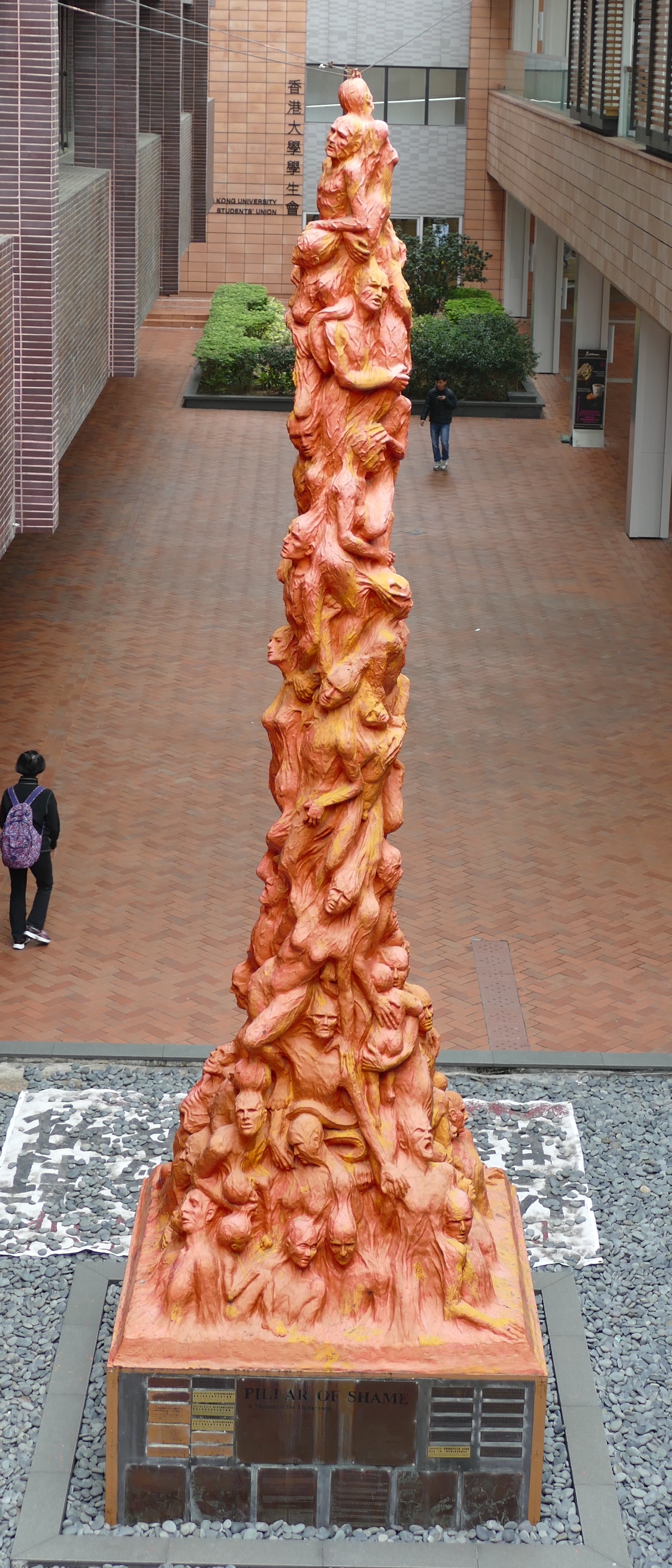
Click on image for full resolution
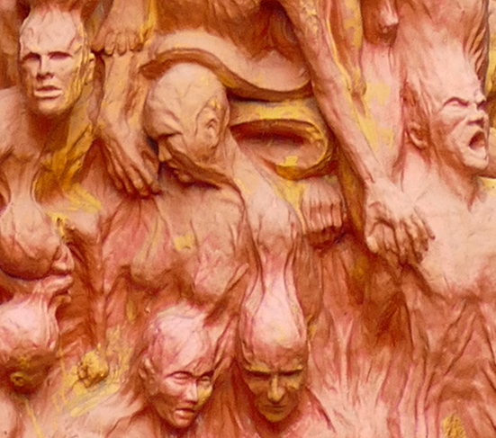
Perhaps nature can only show us what we have already created in ourselves.
The pillars of Cappadocia

Eroded volcanic rock in Goreme National Park, Cappadocia, Turkey. Source: https://www.picturecorrect.com/tips/exploring-cappadocia-with-timelapse-hyperlapse-photography/
The Goreme National Park, a UNESCO world heritage site, is one of the geological wonders of the world. Erosion has formed an unwordly landscape, stranger even than the contortions of Bryce Canyon. This is the land the ancient apostles wandered through, on the way to Ephesus. The sand dunes here are famous, but the pillars more famous. The sand is a recent addition: the rock itself is older, and volcanic: thick tufa, topped by a layer of basalt. Water created cracks in the soft tufa, opening up the deeper rock. The tough basalt on top has protected some columns – so far, not particularly unusual. But the wind has added it effects and the incoming, blowing sand made the columns round, now resembling a forest of stone trees. These 40-meter tall pillars are called peribacaları, or fairy chimneys. Some of the chimneys have been hollowed out, to create living chambers for monks. What a world to live in.
Irish builders

Source: http://www.geograph.ie/photo/5243720 Copyright David Hillas.
The Giant’s Causeway struts from the coast out into the sea, disappearing under the waves like the elephant above. For all effect and purpose, it looks like a flooded road. The famous part is on the coast of Northern Ireland, a place of plenty of weather but a distinct lack of climate (you can get wet year-round). The road resurfaces across the sea, on the Scottish coast, but it is less accessible on that side.
The strange pavement was considered a road for giants, specifically for one called Finn McCool. Nowadays we know better: it was formed in the middle basaltic outpourings of the opening of the Atlantic Ocean. (There were three eruption phases but only the middle one created the causeway.) The hexagonal structures came from slow cooling of the lava flows: as it cooled, it shrank, and just like hard dry soil, it formed hexagonal cracks. Erosion did the rest.
These structures are not that uncommon, but this one is both accessible and impressive, and has become Northern Ireland’s only UNESCO world heritage site.
What lies beneath

The Devil’s Tower in Wyoming, USA, sticks out like a giant tooth above the landscape. It is quite an awesome sight, a strange artefact in an otherwise normal-looking land. Naturally, it was a site for Indian ceremonies – how could it not be? But it equally impressed the settlers and it became the US’ first national monument.
It is a volcanic plug, dug out by erosion of the surrounding land. Whether lava ever reached the surface is not known: what we see is the solidified conduit feeding the (or fed from) the magma chamber. Once, the surface here was above the top of the plug. But as the land came down, the plug rose above it, and now it dominates the scenery like an isolated sky scraper. It seems hard to believe this is not an artificial construct!
A matter of light
These are eye-catching solidified structures, giving the impression that they are something else. It is our brain that interprets the structures in terms of things it is familiar with: we are only deceiving ourselves. But unsolid things can also fool the eye.

It is difficult not to see a smoke monster walking towards you! Which is perhaps not an unreasonable way to look at a big eruption.
Below is a famous picture taken from the very peak of El Teide. The setting sun creates a vast mountain shadow, stretching up into the sky. Even the shape instantly calls out ‘Volcano!’. But it is a bit strange that the shadow is far more triangular than El Teide itself. In fact, the shape of the shadow will be similar on any tall mountain, and it hardly depends on the shape of the mountain. A table mountain would show a triangular shadow.

El Teide in the shadows. Source: https://www.moillusions.com/triangular-shadow-of-a-volcano/
The reason is that the shadow is cast on the sky itself. The shadow of the top of the mountain is tens of kilometres away. Lower down, the shadow is closer to us. The shadow is the contrast between the part of the atmosphere that it still receiving light from the sun, and the part where El Teide intercepts that light. Low down, the sun does not get far because in the distance, it has already set. Higher, it illuminates the sky far longer. I remember once seeing a rainbow, after the sun had set. It was detached from the horizon, but still showed higher up because from there the sun was still visible.
The triangle is a matter of perspective: the top looks small because it is much further away. The sides of the triangle are like the rail tracks, where the two rails seem to come together in the distance. Even a square mountain will create a triangular shadow. This effect can turn any mountain into a typical volcano – disappearing into the sunset.
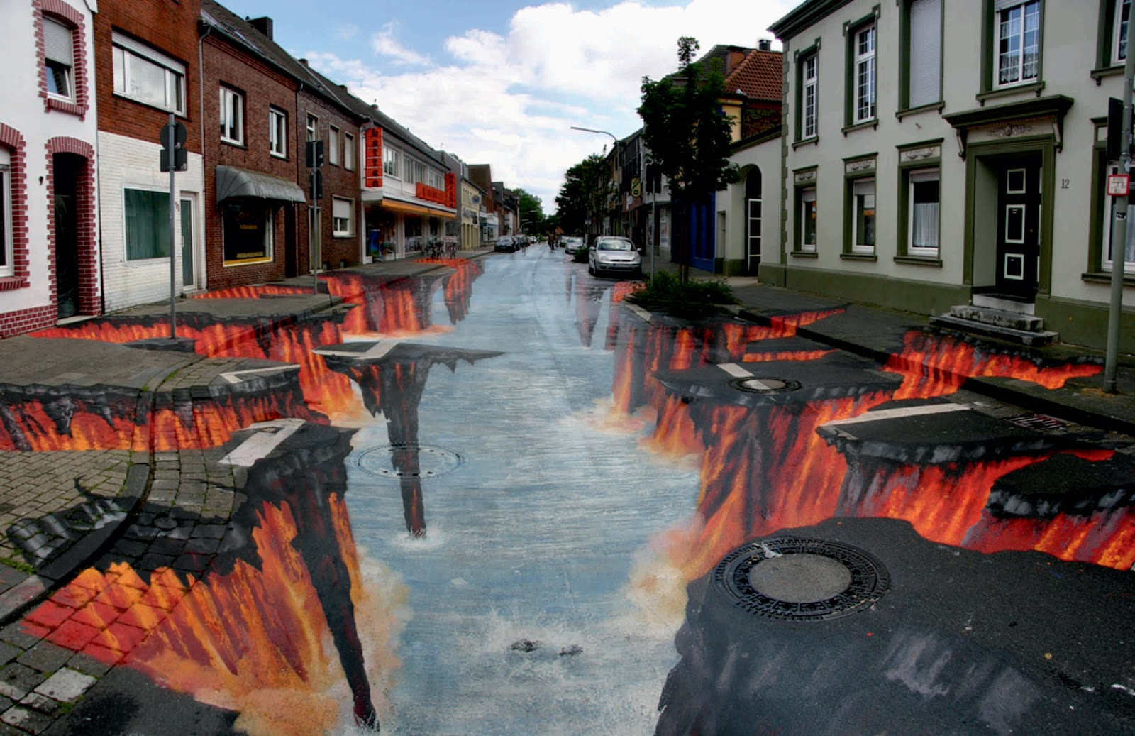
In-depth eruption

And some illusions really are artificial. This is a famous piece of street art: it has turned a street into the depths of a volcano. Our brain can’t deal with 2-d: it wants to see depth where none exists. 3-d movies are so unnecessary: it is much cheaper to make the brain forget about the flat world it is looking at.

In creation
And you can do it at home too. This child will remember its pretend-world for life. Perhaps this was one of you, when your parents designed you an indoor volcano?

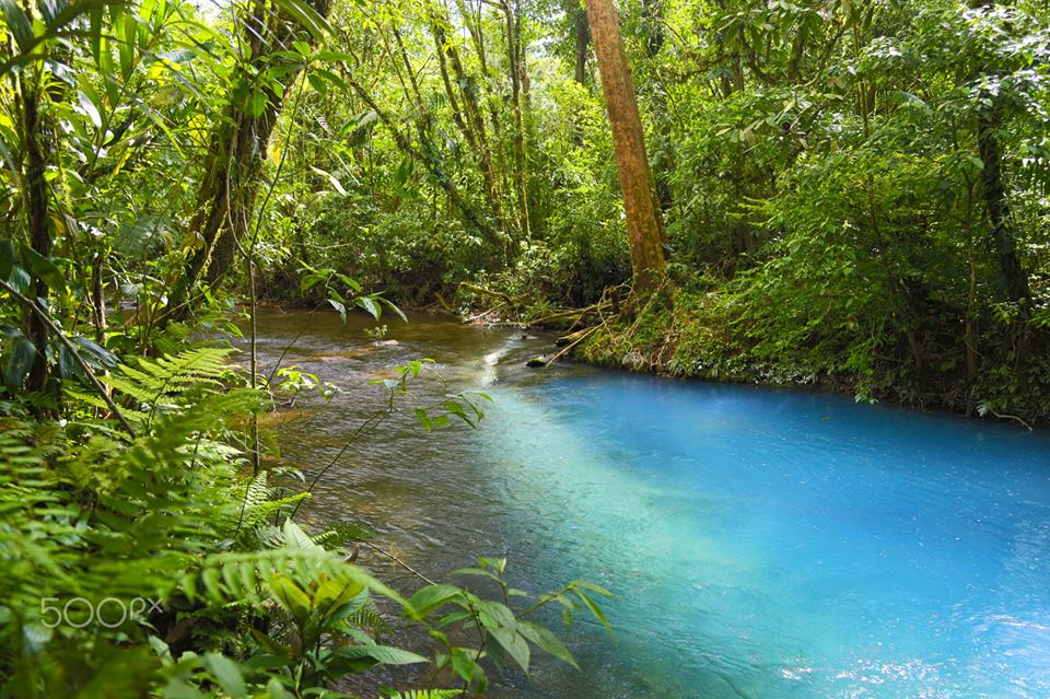
The heavenly river

And sometimes, illusions are really that: optical illusions. This is the famous Rio Celeste, running through the rain forest of the Tenorio Volcano National Park of Costa Rica. The water of the river has a unique turquoise colour. But what makes it blue? Is it the hot springs, or the volcanic water? Other rivers in the area share the same water but they aren’t blue. The two rivers up-stream that merge to form the Rio Celeste, Sour Creek and Río Buena Vista, aren’t blue either, and 14 kilometer downstream, the water becomes transparent again. Various explanations have been tried: chemical reactions involving copper or calcium carbonates, or seepage pollution by the nearby volcano.
Merging of the waters
It turns out the water in the Rio Celeste isn’t blue at all. It is transparent, as water should be. The blueness is an illusion.
The answer turns out to be aluminium sand. The water contains tiny particles of aluminosilicate. The mineral arrives only from the Río Buena Vista: Sour Creek does not have it. The small particles scatter the incoming sunlight, but because the particles have a size similar to the wavelength of blue light, they are especially effective in scattering that colour. It wouldn’t have mattered if the water had been deeper, because the other colours in sunlight would just have scattered back from greater depth, but the Rio Celeste is not that deep. So the other colours reach the bottom and are absorbed by the substrate, while the blue light comes back out.
So why is it seen in only this stretch of water? It turns out that the particles in the Río Buena Vista are a few times smaller than in the Rio Celeste, too small for the scattering to work well. Sour Creek brings in acidic water, and the combination of the aluminium silicate and the low pH causes the particles to grow. Eventually, 14 kilometre downstream, they drop out, and the water turns clear again. It happens nowhere else in the world.
Whether you are looking at rocks, mountains, eruptions, or water, you may be seeing something that isn’t there. Do be warned.
Albert, April 2018


Awww… that 3-D street art is staggering, but some views from other perspectives would also be cool as they would look strange.
Packed me sandwiches and flask for the dungeons….
we will charge you rent soon
Perhaps here’s where one of the giants that built the Giant’s causeway rests.

Mt. Carmel is a traprock ridge born of the same eruptions that formed the causeway. It’s profile has often been likened to that of a sleeping giant, and the mountain comprises Sleeping Giant State Park.
Great photo!
How old are the causeway formation? Could it be related to the previous post about the missing Norwegian volcanos?
The Giant’s Causeway lavas were formed ~ca, 55-60 million years ago, or during the Paleocene Epoch (65-56 Mya). This is about the same time as when a series massive flood basalt flows erupted in what is now eastern Greenland, parts of the northern UK, Ireland and Norway – and at the same time, the opening up the North Atlantic. The Giant’s Causeway and these flows are part of the North Atlantic Igneous Province. As for the “missing Norwegian volcanoes”, there really isn’t any real link, apart from a common (but vague) link, which is the Icelandic mantle plume.
Does anyone here know that Art Bell died?? RIP he probably did more good than i did…. He invented ‘Coast to Coast’ radio show……….. motsfo
maybe no one here is old enough to remember him….. my age is showing….. 😉
I would have offered condolences, but Coast to Coast is not the same program as he invented. I’m currently in a tit-for-tat argument with them over their billing practices. They refused to answer my question, so I told them to pack sand.
I’m a ZZ-Top fan. If you listen to the song Dredmonboogaloo, you can hear audio samples of the Coast to Coast taglines. “East of the Rockies”, “West of the Rockies”, “On the wildcard line.”
https://youtu.be/t7L5VgvQEXI
My issue is that I don’t want auto re-subscribe. I don’t need some random debiture hitting my account that I forgot about. Failing that, they lost me as a customer.
(And the only reason that I was a customer is that sometimes their program shifts from one station to another and I don’t like having to dig around to find the new station.)
For all, they cover pretty much anything from the Moon-bats to the downright strange. I discovered them through a friend of mine who is a county sheriffs deputy. They are really good as something in the background to listen to at O-Dark Thirty when you can’t go to sleep, or are not allowed to. As Art Bell noted on a Larry King interview, the program content would not work with a daytime audience.
totally agree about the Coast to Coast after Art Bell left…………… or did You have trouble with it before he left?? i felt he was supportive of people and did many helpful things quietly without fanfare or the general public knowing. Anyway….. another one gone.
Afterwards.
It’s not really an issue that the host would be involved with. Mainly the practices of the billing jerks. My opinion is that if I want to renew a subscription the onus is on me to do so. I don’t want some mysterious charge hitting my account because they assume that’s what I want to do. There is no option to do it other wise. All correspondence with them is as if I am talking with some vapid idiot who can’t even read the original complaint. I’m not gonna be jerked around by them so, they can kiss my ass. They aren’t that important.
(Yes, I am an insufferable jerk. I revel in that. Scientific American lost my subscription since they could never get my last name correct. Each issue kept having more and more perturbations and syllables added. When they got to three syllables, I told them to pack sand as well.
(It’s one syllable only 4 letters long) There is no direct translation to English, and has no meaning in German. IF you render it in Elder Furthark Runes, it means the guy with the divine gift of a torch. So, my guess is that some clam diggers were quite happy to see my ancestor show up with a torch as the sun was going down. Mudflats can be treacherous.
The same with all corporations above mom&pop size. It’s a combination of four factors: personal service (or even properly remembering previous interactions) apparently doesn’t scale well; playing dumb is a widespread corporate strategy for legal CYA; and playing dumb is also effective as a way to gaslight customers who are being treated abusively. Oh, and it also drags things out enough that you might just give up and concede, in which case they win, or else they manage to ding you another recurring payment or two, or hang onto money they owe you for longer before giving it back (= extending an interest-free loan from you to them).
So that’s why your alt login for when your main one is borked is “the guy with the torch” …
Ding!
And oddly enough, I carry a Mini-Maglite flashlight with me where ever I go. (UKians commonly refer to a flashlight as a torch)
The flashlight is for when my eyes just don’t have enough firepower to read the fine print or see into dark spaces with lost screws lurking around.
And one of the strangest things I found lodged in a printer. What appeared to be a tooth in the manual paper tray of a printer, causing the jam. Turned out to not be a tooth but a broken bit of a peanut. The office manager insisted that no food was allowed at the workstation, I showed her the piece of peanut to prove otherwise. Even crushed it with a pair of tweezers to prove that it was not a tooth.
Another common illusion is that of a range or group of mountains that appear to line up nicely side by side, along a ridge that looks like it would be awesome to hike along.
Except, when you get closer you realize they are not side by side at all, but spread over a mich larger area. Some are closer, other much further away, they only looked that way when viewed from afar.
I grew up looking at mountains just like that, and learnt early that things are not always as they seem.
(Similar to the stellar constellations, too. Same principle at play, there too.)
“only looked that way when viewed from afar.”
If you’re in Afar, you’re in a rift valley. Mountains would be in the distance…
(Yeah, I know. I’ll go away now.) {At least Erta Ale isn’t that far away, so I kept the volcanic connection. 😛 }
Good one 🙂
Booooo! Get off the stage! 😀
GL Edit: {snicker}
An interesting article on (ahem) (cough)…Yell..(cough)..owstone is here: https://www.sciencedaily.com/releases/2018/04/180416185610.htm all to do with the underlying magma layout. It’s genuinely interesting and should not stir the lurking nutters. I hope.
And another “Yellowstone-the-big-one-is-coming-!!!!” YouTube video from Ms Greeley in …3 …2 …1.
USGS HVO have nailed their colours to the mast in the latest Kilauea bulletin today:
“Observations and measurements of the Pu’u ‘Ō’ō eruption on Kīlauea Volcano’s East Rift Zone during the past month suggest that the magma system beneath Pu’u ‘Ō’ō has become increasingly pressurized. If this activity continues, a new vent could form at any time, either on the Pu’u ‘Ō’ō cone or along adjacent areas of the East Rift Zone… A new vent located on the cone of Pu’u ‘Ō’ō would erupt lava flows onto one or more sides of the cone that would initially advance downslope rapidly within a few kilometers (miles) from the vent. Because of the potential for a sudden breakout anywhere on Pu’u ‘Ō’ō, the cone is extremely hazardous. The location of a new vent or potential lava-flow paths cannot be estimated until such time that a new vent forms and stabilizes.”
pu’u’o’o is now with one centimeter length of the highest over the past 5 years. The current inflation rate sees that in reach within a few days. And Kilauea is now also inflating. I would expect an outbreak along the rift but this is guessing, really. The lava lake may disappear if this happens: if this allows ground water into the conduit, there would be a nice explosion.
Well in 2011 the lava lake entirely drained and there was no steam explosion, apparently the water table is at about 400 meters below the existing caldera floor, and a lot further down than the bottom of the lake. However if the overlook crater collapses then I guess this comparison is pretty useless.
Probably the most unlikely scenario but also the most dangerous would be a fissure eruption downrift of pu’u o’o. Not like the small ones there in 2007 and 1986-1992, but something akin to the 2011 outbreak, or maybe a black swan event similar to the initial fissure in 1983 (or on a black hole swan level something similar to the 1955 eruption…). If only the magma chamber under pu’u o’o breaks, then the situation will be about the same as it is now, but if the magma from the summit flows into pu’u o’o then things could be much bigger than what happened in 2014 and 2016. If a high volume fire fountain type fissure (e.g. 2011 eruption) happened on the northern side of the rift zone then things could reach inhabited areas within days, and given that the vents would probably be at a lower elevation than any that are there now so a pretty big flow could flow towards lower puna – the first lava flow in that area in 600 years.
Its unlikely, but if new gas-rich magma from the summit directly erupts into pu’u o’o then things could change suddenly, though probably only temporarily. The last month of the mauna ulu eruption was characterized by extensive lava flows erupting as lava fountains from the summit of the shield, similar to the events of its formation 5 years earlier.
A third option is the rift just southwest of Kilauea. The earthquakes over the past day show a pattern of having a depth of 8 km north-east of the crater, to 2 km southwest of the crater. 2km is still pretty deep. But if it does find a weakness there, it would make a safe location for an eruption!
https://volcanoes.usgs.gov/observatories/hvo/hvo_volcano_watch.html?vwid=457
If it goes into the southwest rift then theres a fairly good chance it will end up here.
And in other news, today is the anniversary of the San Fransisco earthquake of 1906, and of Albert Einstein’s death in 1955. And my birthday, reaching an age of xx years (fill in your favourite 2-digit number). Decision time: celebrate, or head in the sand? Or both?
Happy birthday Albert! You should celebrate of course. Take any opportunity you get to celebrate and enjoy. Life is too short to be stuck with the head in the sand. Sure, if it’s volcanic, then by all means study it. Just don’t stick your head in it 😉
Celebrate by making and consuming a (or many) volcanic inspired alcoholic drink(s).
You can stick your head in the sand the following morning…
Celebrate EVERY day…… 😉 Best!motsfo
(keeps them guessing)
Its always best to celebrate another trip around the sun! Happy Birthday…..that is if the earth really does go around the sun??
Also mine, Albert….Reserved for only the best of people obviously !
Ah, just late. Hope you did celebrate! Cheers!
Celebrate! Happy Birthday, Albert
It’s still April 18th here.
Belated birthday greetings, Albert. Life doesn’t necessarily stop once you reach a certain age. My wife and I have both recently passed 65 and we are contemplating a trip out to Castleton in the coming weeks, thanks to one of your previous articles triggering a childhood memory. I haven’t been in the Blue John Cavern since I was a child – time to renew an acquaintence with fluorspar.
I’ve got chunks of Blue John from my childhood trips back up north. As well as numerous fossils from the limestone areas and a big chunk of millstone grit.
> Mini-Maglite flashlight
Flashlights are a bit of a hobby for me 🙂
If you’re going to carry a flashlight, seriously look at getting a Nitecore Tube for about $12. I picked one up for Christmas, ultra handy, usb rechargeable, lithium battery, slim fit and can easily be held in the mouth if necessary.
I’d post the link but just go to your favourite buying site and look for “nitecore tube”. Manufacturers site:
http://flashlight.nitecore.com/product/tube
… while we’re at it, if you ever buy rechargeable batteries look up eneloop.
I’ve been wanting a smaller one since the mag lite is a bit heavy.
I’ve been using the mini since they use the high intensity single cob led and last quite a while on battery. Plus the batteries are a really common size.
A less common usage for the mini-mag is that it can be used as a “come along” device if I get jumped in a parking lot.
On a stupid note, I lost my glasses the other day. Wound up peeking around inside my recliner with an endoscope tethered to my phone. No luck. They turned out to be sitting on a bookshelf.
Oh, i can one up You on the ‘Stupid Glasses Moment”….. i tried to put my computer glasses on while i already had my reading glasses on…. and was caught doing so….. ((nuts)).
My wife has extremely curly hair and often has two pair in her hair and another on her face. We’re just waiting for her to then ask where her glasses are J
I shouldn’t laugh though, I’m not much better.
Happy Birthday Albert! Bardarbunga has an interesting line of seismic activity as a gift: http://en.vedur.is/earthquakes-and-volcanism/earthquakes/vatnajokull/ . Seems to take in Holohraun and Askja. (excuse spelling).
It’s just liw mag quakes from the dyke cooling that just so happen to include a few Askja quakes. Nothing to see here… 😉
Happy Birthday Albert!!!
Awesome pictures! Just finished catching up on reading the last couple of articles. Thanks Albert & Carl. 🙂
Inflation in Hawaii is continuing at pace. The length along the Pu’u’o’o crater is now as big as it was in June 2014 (the eruption that threatened Pahoa started June 27 that year). Kilauea is now also expanding.
The more this continues, the less likely this seems to be heading for a simple repeat of the last breakout. The inflation of pu’u o’o up to about two weeks ago looked to be going that way, but now that the summit is inflating this could be much bigger. Even if the magma intrudes into the southwest rift and ignores the existing pu’u o’o conduit, I think there is enough magma that it would erupt anyway. Kilauea has inflated starting from before the lava lake overflows 3 years ago, and it looks like the so called draining event afterwards actually didn’t really do much.
It would be convenient if there was a deformation graph from before 2011 to compare to the current situation, but my guess is that it is significantly higher now considering the levels of both the summit lava lake and the crater floor of pu’u o’o are much higher than in 2011 (80 meters below the floor of halemaumau was considered very high back then, while 40 meters below the edge of the overlook crater is considered very low today…)
Maybe everyone has overlooked kilauea with the apparent very slow progression to a future eruption at mauna loa, but the next eruption on mauna loa might well be small and restricted to the summit, while a vent or fissure opening on the north side of pu’u o’o would cause a lot of damage and for a long time.
I wouldn’t go that far. The sudden inflation suggests magma accumulation but the amounts need not be that large. The total inflation is still within range of that of 2014. The rising lava lake in Kilauea suggests that the magma is backing up there, but the amounts need not be huge. For calculating the total volume, GPS or INSAR over a wider area is needed. What we have is extension of the crater(s) which is not quite the same.
I did notice that Mauna Loa had taken a breather in recent months, so there may be some pressure correlation between the two magma systems.
There used to be plots of historic GPS data on the HVO site. Do they still exist?
The deformation looks small because the recorders are both on the edge of the source of inflation. One of the recent images from HVO actually says there has been uplift of the crater floor on the scale of at least several meters, which is pretty significant when the inner crater is 150×140 meters across. Pu’u o’o is not like a bigger volcano where significant deformation happens distant to the volcano itself, pretty much everything is local because it has no vertical magma feed from the mantle, the only distant deformation might be on the dyke complex leading to it, but that is not being caused by pu’u o’o.
The equipment at the summit is at uwekahuna bluff on the west side of the caldera, while the centre of deformation is roughly centered on the lava lake and slightly south of halemaumau, so again the readings are from the edge of the deformation zone, HVO probably have more detailed views of the deformation that aren’t shown on the site, but that doesn’t really help because no-one here works at HVO (as far as I know).
Realistically everything now is like a scaled up version of the situation before 2011, so the potential size of the end result could be similarly scaled up from the kamoamoa fissure eruption. Combined with the fact that any vent opening generally on the northern side of the pu’u o’o complex will now send flows directly to inhabited areas, and things could get interesting.
At the very least there should be some good pictures of whatever happens, and a detailed overview of the observations.
And in the land of more unusual volcanism there are signs and portents.
During Tuesday and onwards a large amount of ashy mud has floated ashore in rafts at the Swedish West Coast.
I was called in yesterday to take a look at it, and my initial judgement is that it is most likely a mudcano that has erupted on or near a faultline running down from the Norwegian Faultsystem between Sweden and Denmark, but within the influence sphere of the Norwegian magma system.
If it is a mudcano it has most likely been caused by warming and expansion of methane.
We are waiting for laboratory analysis of the ejecta to discern if it is a mudcano, or something else. So far we know that the material contains no organic structures.
The Coast Guard and the Oceanography Department is looking for the point of origins exact location.
No volcano-seismic signals have been detected in the form of volcanic or tectonic earthquakes associated with regular volcanism.
Are the ashy mud rafts large enough to show on satellite?
A belated happy birthday to Albert 🙂
http://strangesounds.org/2018/04/mysterious-ash-found-floating-on-waters-off-sweden-is-from-underwater-volcanic-eruption.html
Is this it? Its probably a climate change thing rather than a volcanic one, most volcanoes dont erupt significant amounts of methane.
Mud volcanoes can.
Very interesting….. is it even vaguely related to the ‘quick mud’ that forms near glaciered lands?? Best!motsfo
Living right in the middle of it on Fotoe Island outside Gothenburg. Got a feeling it is organic stuff. Foams on and in it, but that may be microorganisms that grows on the stuff. Will be interesting to see the results from the analysis…
Not good. If the North Atlantic methane hydrate beds are starting to go, then we’re all in deep trouble.
I doubt that the sea floor around Sweden is cold enough for methane hydrates. It is more likely to be in the substrate. Another possibility is perhaps a land slide along a river, s small version of the Rissa event.
After reading the several Hawaii posts above I got in the mood and searched for some Hawaii volcano videos. I’ve found the following, mesmerizing, 17 minute long video of lava flows from last year. It reminds me sometimes of old Hollywood B-movie sf monsters.
Reportedly, Mt Io in Japan erupted and caused a fatality. With as small a plume, it had to have been a Hekla sort of scenario, with the victim being quite close at event start.
The warning level has been raised now to level 3, do not approach the crater.
However, as you can see on the webcam picture, a main road crosses at maybe 100 meter of the volcano.That road is the only road through the area.
It’s a real small crater and if there’s fog around (when I was there you could see for about 20 meters for a few days, however it was completely quiet then) you can easily walk into it, there are no barriers.
It’s a beautiful hiking area by the way
Please do you have the link to the web cam? I can’t spot it out on the Volcano Cafe links (but then I often can’t find my glasses, either…!)
Sorry, I did not realize it was a live link. It’s indeed an mbc cam from the link provided by emptout below, but I’ve found it here, which has a great collection of volcano webcams
http://volcams.malinpebbles.com/pubweb/Japan1.htm
There are several live youtube streams now
This one has a few views: https://www.youtube.com/watch?v=FScrGXxf7Gk
From the views of the youtube cams I noticed something I had not realized before. The eruption proper seems to be getting out of the crater, but you can see some pretty big fumaroles outside of the crater, on the other side of the road.
Now here it gets pretty interesting, because just outside of view of the cameras, there is a crater lake, a maar I guess. Those fumaroles are getting very close.
Were those fumaroles there before? If they are new then things could be interesting.
I had never seen the youtube cameras before, just the static MBC one, from that one I never could see that these fumaroles were also outside the crater. But on on youtube video from Oct 22nd 2017 you can see they were there as well, but hardly as active as now
This is the link from that day, more or less around the 2 hour mark you can see it.
The same channel has a live stream running now
https://www.youtube.com/watch?time_continue=4&v=wRamEu2wSDQ
I have to say It’s a kind of weird to have been in exactly the same spot a few years back, completely sereen and now showing it’s hidden potential again
I guess if this vent hasn’t erupted in 250 years and that the previous eruption was also its formation, then there isn’t really much to go off, apart from maybe a new cone forming there starting from around now.
Apparently the 2011 eruption at shinmoedake was the first magmatic eruption at the complex in 200 years and so for another magmatic eruption to happen only 7 years later and then to be followed by new activity at another location within a month is something significant and worthy of more attention. It is, after all, in the same tectonic setting that has produced at least 10 VEI 7+ eruptions in the last half million years.
I think the fumaroles were there before. Been looking at some pictures of the crater and I’ve seen some vigourous steaming in a lot of them
This was held by the system for approval. Future comments should appear immediately – admin
When it all started: https://twitter.com/fikgm/status/986908610012758016?s=20
http://www.mbc.co.jp/web-cam/
I think they provide jpeg images.
“Pu‘u ‘Ō‘ō appears to be at a critical juncture”
https://volcanoes.usgs.gov/observatories/hvo/hvo_volcano_watch.html?vwid=1361
The HVO put together a virtual flyby:
https://volcanoes.usgs.gov/observatories/hvo/multimedia_uploads/multimediaFile-1902.mp4
https://www.youtube.com/watch?v=LnJ9a_cwA4U
A short video on what might be kilauea’s forgotten eruption, November 16-17 1979 in pauahi crater on the upper east rift zone (where there has been earthquake activity recently). This was the last eruption on the east rift before pu’u o’o started 3 years later. Not a big event at all but in a quite accessible location should a similar event happen now. There is believed to be a shallow magma body under this area so an eruption here might be in the realm of possibility. At the rate other previous events have happened we should find out within a month (maybe less than a week).
Same volcanic system as Shinmoedake which has been erupting quite recently.
Sharp change in the uwev GPS on north west of the caldera.
Part of the GRIM-UWEV clean local measurement on the deformation page.
Note that UVEW is moving west and north, i.e. away from the crater, but not up. So the magma build up is shallow and not underneath UWEV. In fact none of the stations around Kilauea show much uplift.
There are now some earthquakes along the southeast rift zone. You would expect inflation here but so far there is little sign.
The magma chamber is actually not centered within the existing caldera but under halemaumau and the area south of the existing caldera, so in the future when a new caldera eventually forms it will be south of the one that is there now. Some of it extends towards kilauea iki and the east rift but as far as I know the northern part of the caldera and outside the caldera near the observatory and towards Volcano is probably very unlikely to see an eruption any time soon The HVO tiltmeters and GPS are not actually over the magma chamber but next to it, so there isn’t going to be a lot of uplift there.
This is also why the side numbers are in centimeters when the lava lake and pu’u o’o rise and fall on meter scales, because the instruments aren’t at the center of inflation (if there was one in pu’u o’o crater it probably wouldn’t exist for more than a few weeks anyway)
Evidently there is pretty significant uplift at pu’u o’o with the crater floor having risen several meters and the lava pond there close to overflowing. Uplift at the summit might be interrupted by the fact there is an open vent system to the lava lake so the lake rises up a lot instead of the magma chamber inflating, but the high lake level should be enough evidence to show the system is pressurised, the lava lake is about 300 meters higher than the vents at pu’u o’o so in theory the entire lake could drain with no changes to the existing plumbing in the east rift zone, but this hasnt happened since 2011.
Another great presentation!…. love watching how long it takes him to get covered with chalk. 😉 Best!motsfo
nick is really good,
re the smoke monster: are we SURE there is no such thing as mountain kami?
I’m not dismissive of the unknown. Just the ludicrous. Kami may in fact be at play here. It’s really no different than my claim that volcanoes hate statistical predictions.
perhaps the mountain kami are bad at math.
Just checking the cams for Pu’O’o and it looks like the floor has slightly collapsed again… https://hvo.wr.usgs.gov/cams/panorama.php?cam=POcam
any way looks different…
Best!mosfo
and now everything is fogged in…… can’t see anything now…. but you could before….. sigh… from motsfo
It looks about the same as it was before to me. If there was a big collapse then there would be a big drop on the deformation charts, and very likely a new lava flow somewhere on the flanks, which hasnt happened (yet). I think the cam you linked to is slightly distorted to show the whole crater, at least it looks that way to me.
The longer this goes on though, the bigger the show at the end, so things could be interesting when it all breaks.
Thanks, TBM! Best!motsfo
Apparently a very big explosive eruption has happened at zheltovsky volcano in kamchatka.
http://lechaudrondevulcain.com/blog/2018/04/22/22-avril-2018-fr-zheltovsky-khangar-dukono-kanlaon-kilauea/
The only other historical eruption of this volcano was in 1923, and with ash reaching up to 14 km high on april 19 this could be the first VEI 4 in several years.
There is not much info on this volcano except that it has formed entirely within the holocene (inside a late pleistocene caldera) and had at least two VEI 5 eruptions.
Actually the other kamchatka eruption on that list might be even more significant, from khangar volcano. It is its first historical eruption, its first eruption in 500 years, and also the first historical eruption in the srendinny range (northwest of the main volcanic arc). If both of these reports are of real eruptions then this is definitely something to take note of.
No one else has reported this.
Lots of stuff that happens in Kamchatka goes unnoticed by the rest of the world. Basically every report of activity is a satellite observation of ash from either klyuchevskoy, shevluch or bezymianny. There are exceptions, like the activity at tolbachik in 2012, but generally the only stuff that escapes the basic reports are big events like what happened at bezymianny in december last year.
These eruptions also happened at night so there probably wasn’t anyone near the volcanoes at all, particularly khangar which is about as in the middle of nowhere as you can get.
In any case, something had to have created a 14 km high ash cloud for it to come up on the satellites.
Being down wind of the Bad Boyz of Kamchatka, I just got my tomato starts going…
Grrrr.
both eruptions are marked by KVERT at 04/20/2018 as VOLKAM18 EXERCISE. It seems there was no eruption at all.
These were VAAC test runs!!
Sounds like a risky exercise when the international media has largely reduced to the point of clickbaiting mass destruction events.
I wouldn’t be surprised if one of these volcanoes eventually appears on an eruption list in this way for real though, they are both almost completely unmonitored, and khangar does bare a striking resemblance to pinatubo…
Southern Kamchatka really has a lot of big calderas.
I agree that it’s misleading. The way to be sure a KVERT test is underway is if the alert level quickly goes from green to red to orange and crucially if it goes orange to green without going through yellow (in real cases alert levels always decrease in sequence, they can only be skipped when increasing, plus if the alert jumps straight to red, it’s not going to be back on green after just a few hours!) and also if there is no report from Tokyo VAAC. Just in case any media see this, to reiterate, Khangar and Zheltovsky have NOT erupted and remain on green alert.
Thanks for the link to the blog.
Interesting. 1st wedding I’ve been to where the groom wore a 3 peice suit and flip-flops. (It was on the beach. Not a bad ceremony. There was a guy surf fishing in the background)
The lava lake has started overflowing, almost exactly 3 years after the first overflows occured on April 28 2015. Things are getting interesting.
https://volcanoes.usgs.gov/volcanoes/kilauea/monitoring_webcams.html
What annoys me is that a few years ago I planned to do volunteer work at HVO when I finished school, and I would have been doing it this year and would have seen this all happen in real life…
I think I was being WAY to optimistic about the dates though (and actually living in hawaii and being an american citizen probably would have helped too…)
I just found a website showing all kinds of geographical maps from Japan, you can choose your layers, 2D or 3D and cross sections as well. Also plotting points can be exported (I did not check that though) Apparently you can even print the 3d maps!
However, you need Google translate or similar it’s completely in japanese. Fortunately all menu options will be translated. The map locations names not though.
I thought this might be handy, the maps are very detailed.
This is the link centered on IoSan or IoYama ( I did not choose the colors)
http://maps.gsi.go.jp/?ll=31.946846,130.853219&z=15&base=std&ls=vlcd&disp=1&cd=f0&vs=c1j0l0u0&d=l#15/31.946846/130.853219/&base=std&ls=std%7Cvlcd&blend=0&disp=11&vs=c1j0h0k0l0u0t0z0r0s0f1&d=l
This is the home page
http://maps.gsi.go.jp
The expansion of Pu’u’o’o is continuing relentlessly. It is now larger than it has ever been, I believe.
The inflation of the crater floor is now visibly obvious, the floor is like a shallow dome compared to being flat like it was before. Halemaumau also overflowed last night, only briefly but if summit inflation continues then the next DI cycle should see a substantial overflow.
It is not the most likely scenario now, but if I lived in the area north of pu’u o’o down to the ocean, I would consider evacuating as a possibility. If a vent opens on the north side of the complex then any lava flow is going to go straight into northern puna. The 2014 lava flow managed to get about 24 km so something similar would be expected in a new flow, and 24 km downstream of pu’u o’o there are a lot of subdivisions and unlike the 2014 lava flow this one would cross the highway before getting that distance.
Let us muddy the waters!
http://www.volcanocafe.org/the-goop-and-the-mudcano/