
The Eldvórp Crater Rows. Image honestly stolen from Iceland Magazine.
Geological time is interesting, because even the geological now is decades long, if not centuries. The current geological episode at Reykjanes didn’t start with Fagrafjall (it is no longer a valley, so let us drop the “dal” out of Fagradalsfjall shall we).
Nor did it start with the large and very noisy intrusion over at Thorbjörn a couple of years ago. No, it started over at a relatively unknown diminutive volcano called Hromundartindur in 2007, where a minor root-filling occurred accompanied by some 80 000 small earthquakes.
Another minor one occurred at Krysuvik at little later, but everything was still small and benign. Over the years other small and noisy intrusions occurred all over Reykjanes Ridge and Reykjanes Peninsula. None of which caused an eruption.
In retrospect it was a sign that the pent-up strain in Reykjanes was reaching the breaking point, and that it needed to stretch out and moult like a butterfly from its cocoon.
A lot of time was spent pondering on how much pent-up strain energy was down there in Reykjanes, because earthquakes was seen as the big problem. The numbers turned out to be quite mindboggling if one looked at it from a layman’s perspective, or from the perspective of the “oh, my god” hysterati*.
Because there are 3 M7+ earthquakes worth of energy down there, ready to be released in the form of earthquakes, it is incredibly important to understand that we are talking about energy that will be released in many smaller earthquakes over time.
Why 3 big earthquakes, is the first question? Well, because there are 3 zones that are separate, and each of them contain roughly the same energy. The first one is running from roughly East of Lake Kleifarvatn via Brennisteinsfjöll and Hengill, up to Hromundartindur. The second one from Krysuvik until the tip of Reykjanes Peninsula, and the third from the tip down the Reykjanes Ridge down the MAR.
The next part we need to remember is that the Reykjanes part of the MAR is filled with perpendicular faulting dividing the larger structure into many more manageable parts, so forget that an M7+ earthquake would crack Iceland in one go.
So, instead we will get many earthquakes ranging up to M5+ size, and that is fairly manageable, and something that we have seen during the Fagrafjall eruption.
Hysterati = people who professionally operate a YouTube channel for profit and uses clickbait pictures and title their dubious productions in a hyperbolic manner leading their viewers to believe that the world is about to end. If you are one of those looking for inspiration for a video, please feel free to be offended at this juncture, it was intended. If you instead make videos intended to educate people, no insult was intended your way.
The hen and the egg

The majestic Thorbjörn proving once and for all that there are mighty forrests in Iceland. The beautiful picture was honestly liberated without any ill intentions from Vikurfréttir.
Now, why did I just go on about earthquakes? Normally you will not have a volcano without earthquakes in one form or another. It is therefore prudent to talk about earthquakes and volcanoes a bit more, but this is a very large subject so I will stick to oceanic rift volcanoes in the particular form of Reykjanes for now. Do not overinterpret this to be valid even for every other oceanic rift volcano.
Let us use Fagrafjall as an example. It was a known rift that was perpendicular to the MAR as it transitions through Reykjanes, it was estimated that the total pent-up strain was equal to an M6+ at the rifting fault, something that turned out to be pretty much spot on as the energy was released one smaller earthquake at a time as the dyke formed.
But here comes the hen and the egg question. Is it intruding magma causing the rock to fracture and strain to be released, or is it the strain being released, and the fault pulled apart that suck in magma?
We know from the root-filling events, and other deep origin earthquakes that magma was indeed pushing upwards at the beginning, but in the beginning, this did not cause large intracrustal earthquake swarms. Instead, it slowly helped to add to the strain in the rift-system.
It also meant that there was magma available at many places under the Reykjanes peninsula. What then formed the magma? Well, that is easier to answer, decompression melt.
I think I am going about this in the wrong order, both spatially and chronologically. To answer why Reykjanes is a chicken & egg sandwich, I need to start from the beginning, if there is even such a thing.
The geological second

Happy earthquakes in Reykjanes. Image from the Icelandic Met Office.
In Reykjanes 800 years ago, most of the strain was gone, the available magma had been spent, and life was about to turn dull for the volcano watchers of yon olden days. The eruptive phase of the 800-to-1000-year long Reykjanes rift cycle was over.
For almost 800 years the strain slowly picked up, but there was very little tectonic movement of the plates on either side of the MAR of Reykjanes, the plates were fairly locked in place. In the end of this period the strain was starting to be to large, and earthquakes and small swarms started as the plates started to move apart and against each other, the lock was coming apart.
As the plates moved apart the crust thinned minutely, just enough for the pressure to be lowered at the top of the mantle, and the mantle material started to transition into magma a little bit at a time.
Magma has a lower density compared to mantle material, and thusly requires a little bit of more space, so the magma started to exert force upon the crust above, causing small earthquakes, this is what we call a root-filling event.
Why upwards? Well, the magma is lighter than the mantle material, so it is trying to swim for the surface.
The root of the volcano at the MOHO level started in turn to put more force on the poor rift, and earthquakes started to happen above, creating voids filled with nothing, and nature hates nothing more than anything else, so magma was sucked up to fill in those voids. This of course lowered the pressure at the mantle creating more decompression melt.
The magma that was sucked up in turn caused increased strain above and towards the sides, so new earthquakes created new voids, sucking in more magma, more decompression melt… until Fagrafjall become a runaway train running over both chickens and eggs, the valley disappeared, and I renamed Fagradalsfjall into Fagrafjall.
At other places the going was tougher, and the overburden turned out to be to sturdy for the combination of suction/earthquake/decompression melt to push through. Yes, dykes formed, but they did not dilate enough to give birth to an eruption.
Fagrafjall turned out to be rather unusual in one aspect, it erupted in one go from onset of the earthquake swarm, via intrusion and dyke formation, dilation and to the squirty phase. Normally it takes two or more intrusions to break through.
The reason for this was that the overburden was rapidly weakened further by the pent-up strain, in other words, the strain was greater than the cohesion of the bedrock on top. At Torbjörn the situation was different, at 5km depth the bedrock turned out to be to solid and the intrusion sputtered and failed.
Eldvórp, Lagafell & Thorbjörn

Lagafell is in the circle. Image by Albert, who also found out the name of our little potential volcano.
The intrusion at Thorbjörn was large, at least counted as amount of uplift on a spreading rift goes, more than 100mm of uplift in the original intrusion.
During the time of the Fagrafjall eruption, and from then onwards, seismic activity continued at Thorbjörn, so it was clear that even though the intrusion was over, there was still both strain and pressure accumulating in the system.
So, I was not surprised when activity kicked off again a couple of weeks ago as a new intrusion started at Eldvórp, the next transverse fault over to the west. I was not even a tad surprised as Thorbjörn answered with an intrusive phase of its own just a day later. We had seen these intrusions pinball around before after all.
What was a surprising though was that the intrusions did not form dykes along their respective transverse faults that run perpendicular to the MAR, instead earthquakes propagated towards the middle at Lagafell.
This means that the new Dyke is following along the MAR itself, whatever now the consequences of that might turn out to be. I do though not believe that a MAR being magmatically lubed up by a dilating dyke is a good thing for Grindavik.
The runaway train

INSAR image showing the uplift and inflation area. Image from Icelandic Met Office.
A decade ago, I was really bored one day, so I compiled all the data that I could find for the Reykjanes area bedrock and used finite element method (gobbledygook for heavy math) to try to find out what was the average* point when you could assume that the buoyancy of the magma would overcome the overburden at a rift fault.
It would have made for a fine paper, but alas, I am to lazy to be a good publishing scientist. Instead, I used the average number that I got, 2.7 kilometres, in passing mention for years, until I used it when forecasting the Fagrafjall eruption, and was resoundingly laughed at for it, until Fagrafjall proved the math I had been too lazy to publish, by becoming a runaway train at that depth.
Why am I now mentioning this? Simple, because of this earthquake:
| Wednesday 25.05.2022 |
10:48:50 | 63.868 | -22.443 | 2.8 km | M2.7 | 99.0 | 3.3 km N of Grindavík |
There is also something else that happens at this average depth, and that is that it is where nucleation of volcanic volatiles will start to happen at an increased rate. In other words, this is where volatiles will start to free themselves from their magma prison.
Obviously, I factored that in when I did my heavy math lifting, and it biased the average number quite a bit and skewed the results towards 2.7km. Take this titbit as you wish.
Average = I bolded and italicked this in the meagre hope that itinerant readers will really take note that this was the average value across all of the spots at Reykjanes that I could find relevant data for. The depth was differing across the systems, so average it is. And I also marked it clearly to differentiate it from depths that may differ at other rift zones in Iceland, and in the world. In other words, it is a very good and well built-up mathematical ballpark. The mileage of other volcanoes may vary. M’kay?
Conclusion

The dyke implicated by what was purported to be the Icelandic Met Office, but I am not sure that it is theirs. The origin is at best debatable.
I find that the data is more implicating a bow-shaped dyke along the earthquakes on the Grindavik side of Thorbjörn, but your mileage may vary in this regard.
We are here left with known volcanic formations and rifts. 50mm of uplift in this intrusion, on top of a previous 100mm of uplift in a previous intrusion, we have a dyke that has formed along the MAR, and that is dilating across it, and magma that is now seemingly very near the point of no return.
Now, before you become way to happy if you see an un-checked and un-verified M0.1 earthquake at 1.1km depth, I will throw a spanner in your happiness.
There is a reason I only look at M2+ earthquakes in these situations, and either check them myself or wait until the Icelandic Met Office has checked them. I am most often waiting for the IMO, since I am famously lazy.
A small earthquake is much harder to locate for the system, and to locate properly manually. So, the smaller the earthquake, the bigger the range of errors will be. And this is especially true for the depth locationing.
The accuracy is also depending on the density and quality of the network at hand. Even at the best of times anything below M2 will be 1 or more kilometres off dephtwise at Reykjanes, but an M2+ will be about 500 metres, or even less off from the real location.
So, below 99.0 confidence rating (indicating manual check), and below M2+, do not get overly excited.
Anyway, we are now very near the runaway train that is covered in chickens and eggs. It would only take a comparatively small push to get it going now.
I hope this will not happen because unlike Fagrafjall this would directly impact the lives of many locals since any lava would move towards the town of Grindavik.
If an eruption would occur in the next few days or weeks, the current probable location for a vent to open up is near Lagafell, but this is speculative.
Due to the location, it pains me to say that it is now touch and go.
CARL REHNBERG


Er, where is Hagafell?
In the red circle marked out by Albert.
Ah, the one labelled Hagafell?
I am so silly …..
Except that it turned out that my Autocorrect had betrayed me and the real name is Lagafell…
Oh dear, that’s a bad place for an eruption. Can you move it further from Grindavic please?
I wish I could. 🙁
I’m thinking the same as you, but unfortunately reality might decide to ignore our plea’s…
Grindavik, overrun by Laga. Let’s hope it’s not Stella.
On a more sober note, thank you for a fascinating piece Carl. Watching with interest and let’s hope Grindavik residents are left undisturbed.
Pillian Patera 2.0 under Keflavik 🙂
The red circle is where the shallower earthquake were overnight. The Centre of inflation is a few kiometers further north. Those few kilometers could make all the difference. I feel that this is beginning to look like the run-up to an eruption, based on the continuing inflation and shallowing earthquake activity. The location could still be anywhere within a 20 km2 area. And of course, ‘feels like’ is not the same as ‘will’. Many intrusions fail at the last hurdle. Earthquake activity has calmed down again today. We’ll take this day by day.
If it does erupt, I expect a smaller event than Fagra. But in the area, with the town, the tourism and the power plant (which also provides district heating), that could still be problematic.
It is here good to remember that neither of those earthquakes was above M2.
There is a reason I have been nitpicking on that number for years, below it the locationing is rapidly growing erratic.
I still think that the most likely spot is on the Grindavik side of Thorbjörn. It is where the 3.6 to 2.8km deep M2+ earthquakes was yesterday.
The powerplant is quite safe, the dyke is on the other side of things, and it would currently take a lot to get to it.
The airport will though close down, at least initially.
Some earthquakes yesterday (26/05) were occurring a little further north, just to the west of Thorbjorn.
Thanks Carl: Exciting… yes I wants to move to Iceland! Iceland is souch a mindblowingly Beautyful place with their High Fantasy landscapes. Im looking for education and job skills first, but not soure what I needs for Iceland. But the oceanic subpolar climate is crap, rarely goes above 16 C in summer .. but days well over 20 C happens.
I Hopes the next eruption becomes like the Pillan Patera 1997 .. thats 58 km3 of basalt lava in a week .. Althrough that happened on IO ..
24 years ago 😉
Well the next Reykjanes Eruption.. I Hopes for a lava shield .. that last some time, perhaps an Icelandic Mauna Ulu to excite the tourists.
But will probaly be a fast eruption like the Galapagos eruptions I guess .. soon the blue lagoon Maybe gone I guess?
The next eruption will probaly be a fast one perhaps resemble the Krafla Fires .. perhaps like Kapelluhraun. Reykjanes Penninsula have also lots of pahoehoe, so many eruptions last a long time ..
Fagrafjall basically was an Icelandic version of Mauna Ulu. Was a bit less voluminous and didnt last as long but all the same features. If it lasted just a bit longer the rest of the cone probably would have been buried and a symmetrical shield would be there.
Probably will need to wait until Brennisteinsfjoll erupts to get a years long eruption though, Svartsengi will be probably a relatively low volume and very fast, wouldnt expect it to last for more than a week. Krysuvik is probably going to be much the same, and Hengill, although an eruption there will probably be a bit bigger, and more likely to centralize to a few single vents.
Sorry, but your little joke, shortening of the name Fagradalsfjall, is based on incorrect information. The valley which filled with lava is/was named Geldingadalir. The actual Fagradalur for which the mountain is named is on the north-west side of the mountain. (cf. Wikipedia) Please correct this. It is just a little bothersome each time I see this mistake as I proceed through the article. And things like this tend to propagate. Thanks.
Yes I know which valley is which, but the Mountain is Fagradalsfjäll, and many called the eruption Fagradalsfjäll, so it would be confusing if I all of a sudden talked about Geldingafjäll…
It would also sort of imply that the poor horse had gotten his bits back.
And since the eruption was on top of the mountain I think the nomenclature is correct.
At this point, I’m pausing to consider whether you are just having fun trolling your readers and making fun of the Icelandic tendency to be slow about choosing place names (and arguing about it). I was part of the online community that ended up nicknaming the cone “Ragnar”. So, I obviously don’t have a problem with made up names. LOL And yeah, the better name would actually be “Geldingadalsfjall”. It wouldn’t suggest the horses got their bits back, just that the horses now have a mountain to walk around instead of the valley that it buried. Mind you, if they did that, they would lose more than just their bits. 🙂
My readers have at this time suffered from my sense of humour for 12 years.
I guess they by now have gotten used to it.
I do not troll, since that implies giving out false information to mislead people.
But, I freely admit that it is me poking fun at the Icelandinc naming comittee and their glacial speed at naming new volcanic features.
Trust me, this is mild compared to what happened during the eruption of El Hierro in the Canary Islands. Somehow I named the volcano (with the help of another Admin) “The volcano named Bob” in Icelandic. The day after it was even named as such in Wikipedia and Google Earth. The local authorities have not forgiven me.
Even to this day the volcano is known as Bob, even in El Hierro.
Bob after that took on a life of its own and is nowadays used for any unknown volcano.
Bob obviously came from a character in the TV series Blackadder.
I think “Castration Valley” is badass, like something out of “Deliverance” or a black metal band.
Now it is castration mountain 🙂
Not sure the intrusions under Þorbjorn are dikes, it is a rounded area, probably is a sill instead. Sort of a proto-magma chamber I guess. Would not be unusual to get sills deeper down where the pressure is greater, as soon as a rift opens that makes contact with it all that magma will rush in, the land will sink and we get an eruption. Would be a lot faster than Fagrafjall was though, not good for Grindavik 🙁
Which begs the question of how do shallow magma reservoirs form the first place?
Are shallow magma chambers just a stack of sills that have accumulated in the same basic location over time/milenia, or do they develop from a blob of hot magma moving up from depth (lower reservoir), hitting the dense crust, then expanding like an inflating balloon?
Inside calderas you can often have a series of sills at different depth, connected by vertical conduits. That may also happen in spreading ridges but I don’t know what the state of knowledge is there. (Perhaps still lacking.) In this area, the magma accumulation at 7 km (or so) is likely horizontal, so a sill which could be elongated along the Reykjanes seismic zone. But I expect above that it is a dike, along the direction indicated by Carl
I can only come up with one reason there would be a sill, and that is that either or both of Eldvórp and Thorbjörn are central volcanoes with old mature sill-structure reservoirs.
I do though think that this is unlikely.
Also, the GPS trajectories seem to favour a classic dyke.
There are several such fissure cones in the region, and that can only come from dikes.
Exactly, that is why I have a problem with the sill idea.
The sills are deeper down than the dikes, so a dike will still form to cause the actual eruption but the magma collects as a sill first at some depth (seems about 4-5 km). Svartsengi and Krysuvik have got high heat flow, the only real difference between these and Hengill seems to be that the latter has got some silicic products and a definitive magma chamber. Sills probably are able to get thicker than dikes because pressure is even, dikes will be wider at the top than the base but a sill that is trapped will be pretty well balanced. It will also heat up the area much more, it is heat from below rather than heat from the side.
Would also not surprise me if Hengill is simply the oldest of the volcanoes here, and the others have just not caught up yet.
A sill can be viewed as a horizontal dike.. But they can grow thicker and therefore store more magma. They do need a horizontal fault plane, and this can come from a change in density as different layer of the crust lie on top of each other. There is a very obvious plane at around 7 km (but it varies across Reykjanes) where the basalt flows that build up the peninsula start. Below that is the original oceanic crust. That is why i think there is a sill there. The activity at 5-6km is related to the Reykjanes seismic zone, and is a vertical (or somewhat inclined) fault. Then we have north-south running faults which take up the transform motion. This seem to be the ones that initiate the dike formation. So above ~6km I expect dikes.
Chad, Hengill is a very different volcano, it is only partially a Reykjanes volcano.
It is also a tripple-junction volcano, and one of the biggest erupters in Iceland. It is capable of 5km3 eruptions.
The ones from Krysuvik and onwards are much simpler rift volcanoes.
Hengill does stand out among the volcanoes of its stretch of the rift. Its south trending rift is part of the Reykjanes complex but its northward rift goes up towards Langjokull. But Langjokull doesnt do fast eruptions, at least not in the Holocene, so probably has not got any shallow magma chamber. It is like a gigantic version of Fagradalsfjall, direct mantle eruptions.
Guessing that you are including Skjaldbreidur as being part of Hengill, not sure that is generally the consensus. Obviously I am no expert but the direct extension of the north rift of Hengill seems to be to the deep part of Þingvallavatn and a non-eruptive graben, and that Skjaldbreidur and the other major volcanics north of the lake are part of a neighboring fissure swarm.
Skjaldbreidur is something I am open on.
I think nobody really knows what would be the parent volcano. It might be a unicum.
Skjaldbreidur is a lava shield, my own theory is that those are all monogenetic and happen directly from the mantle. Presumably it begins with an eruption a lot like the one last year which just lasts longer, and perhaps stop when a rifting event happens and destroys the conduit, at least that is what happens in Hawaii. I think the fact they erupt in fissure swarms is just accidental and not really important, those are weak places. South of Skjaldbreidur is the Thjofahraun and Eldborghraun eruptions, which were fissures but slow, perhaps other attempts at shields but unsuccessful.
I guess maybe every now and then a shield turns into a central volcano too, but probably not typically, I think it may be a bit late to revive Skjaldbreidur though eruptions will happen in its vicinity again.
Do you get uplift like this directly above a dyke? A dyke pushes the ground to the sides so you get horizontal movements and uplift away from the dyke. Above the dyke there’s normally subsidence. We saw that clearly in the InSAR images before the Fagradalsfjall eruption and it’s also evident in the GPS trajectories of the December 2021 intrusion that failed to erupt.
For the current intrusion we only see uplift, both in InSAR and GPS.
The picture showing the supposed dyke is originally a misquote of a presentation by Kristín Jónsdottir from IMO. Kristín herself speaks of the intrusion as a sill.
https://mobile.twitter.com/krjonsdottir/status/1528790023772020736
Here’s the original information that was misinterpreted by the person who drew the line on the map. Kristín’s presentation in the video.
https://www.vf.is/sjonvarp/aframhaldandi-jardskjalftavirkni-samhlida-kvikusofnun
Yes, you do, but the subsidence appears only when the dike is shallow enough. Initially you get uplift, and once the dike shallows the uplift becomes more focussed and at the centre some subsidence (and surface cracking) begins. At that point, the line along which the eruption will happen is evident. In a sill, you get inflation over a wider area but the magma may find a way up (a dike) anywhere within the central region, as it probes a wide area for a weakness. Note that a dike does not need to be vertical: it can also be inclined depending on the stress field of the surrounding rock. A sill runs parallel to the surface (so if the ground is inclined the sill also will be) but a dike has more freedom. The propagation of a dike will always be in the direction of least stress.
Dykes do cause inflation if they encounter stiff resistance upwards, this happened last time at Thorbjörn, and this time too.
But, there is ample evidence of the spreading of the dyke in the GPS data.
Remember that a sill gives a Mogi half sphere, and a dyke a more linear change in trajectories. With enough GPS stations it is quite easy to see the difference by just assigning 2D arrows to the locations of the GPS on a map.
To clarify, the bulk of the uplift we see that is widespread is because of lift at the bottom of the crust as decompression melt expands the mantle material, in turn forcing it upwards.
It is a bit tricky to understand what is what due to this.
That is why I go 2D to see the horizontal movement pattern to see if there is a crustal dyke or a crustal sill. Uplift is just confusing in this regard. 🙂
Approximate 2D motions of stations from 25/04/2022 to 25/05/2022.
Think we need more stations to work out what is going on to the west of Eldvörp.
Source for map and deformation data: http://brunnur.vedur.is/gps/thorbjorn.html
Did you look at Kristín’s presentation? It’s in icelandic, but it’s quite good. From 5 minutes in she talks about the previous and current intrusions. From 7 minutes she shows a vertical cross section and clearly depicts the intrusions as sills.
The shape is not circular, but elongated along the reykjanes fault, roughly where the rectangle is drawn. I don’t think a half sphere is a good model for the deformation in this case.
Direct link to the presentation:
https://youtu.be/hFHYirmFY00
Thank you. I know it’s geared towards those in Iceland who need to know but is there an English version? The video looks very informative but I can’t follow it.
No english version that I’m aware of. This was an information meeting for the residents of Grindavík.
The first five minutes describe the process of the 24/7 monitoring and evaluation of weather, earthquakes, floods, etc.
From five minutes on, she says the boxes show the area of the intrusions. The three blue boxes are the intrusions from 2020 and the red one is the ongoing intrusion. She says the model that best fits observations from InSAR satellite measurements is a long and narrow sill. She goes on to explain that as the magma takes up space in the ground, it causes tension that create earthquakes in the surrounding area.
From seven minutes she shows a cross section of the sills, “just like cutting the ground like a cake”, and explain how it causes the land to rise and create earthquakes around it.
Next, she talks about the earthquakes that are well felt in Grindavík, compares with the activity from the previous intrusions and the run up to the eruption. As long as the intrusion keeps going, there will be earthquakes.
From 10:30 she talks about the possibility of a larger quake, M6-M6.5, in Brennisteinsfjöll. The effects of such a quake will be of more concern in the capital area, since Grindavík is further away.
Disclaimer: I’m Swedish and don’t understand everything she says. I get the main parts, but I most certainly miss out on some of the details.
It is much appreciated, Tomas. A ‘long and narrow sill’ is of course rather similar to the start of a dike. It is what you would expect at the bottom of the main fault through the upper crust.
There are some quakes that are under 2 km depth, might be very close now.
We’re in full unkosher territory now (chicken, egg & mayo sandwich).
Latest datapoints in all near GPS stations seem to show a bit of subsidence. Is the magma leaking somewhere? Is it a bit of settling? Probaby the latter. Quakes are also slowing down, and it’s yet hard to tell if there is still horizontal movement the last few days.
An angry Rabbi may set it off, but is there an angry Rabbi nearby?
Earthquakes with depth <3km in the last 24 hrs. There're a bit spread about.
Source: https://skjalftalisa.vedur.is/#/page/map
If I may, those are to small to depth locate.
The only M2+ is at 5km.
https://academic.oup.com/mnras/article/483/2/2185/5181341?login=false
This is for Albert, not volcano related.
Maybe the reason we exist is because the Milky Way didnt properly go through a quasar stage. Seems it will do so rather epectacularly prior to its merger with Andromeda. Given that the MW is thought to be the more massive of the pair now too (less stars but slightly more matter total) most of the simulations of the event might need updating.
Seems perhaps life could well be very rare, maybe only found within really big spiral galaxies with extensive disks that are actively forming new stars, and relatively small centers. There is probably no life in the Andromeda galaxy, and very likely none in a monster like M87.
That overstates it a bit. A quasar is a phase in the development of a supermassive black hole, perhaps 10^9-10^10 times the mass of the Sun. Our galaxy has a black hole with a mass of around 4 10^6 times the mass of the Sun. Even if this were to increase by a factor of 10, we still are far below that level. Neither is it clear that a quasar sterilizes its galaxy. The energy is mainly directed outward, not in the plane of the galaxy. There are two other effects that can play a role. A merger can trigger a phase of very high star formation, soon after followed by a high rate of supernovae. That could cause a problem if one happens very nearby (still not too likely). Second, a quasar can drive gas out of the galaxy. That stops further formation of new stars and over time affect the chances of new life. But old life is safe. You should also note that the milky way has had mergers in the past. Not very large ones, but sufficient to form our bulge and thick disk. Andromeda had a similar one more recently (we know that because its halo contains younger stars than ours), but again the galaxy is just fine, with plenty of young stars around. No panic.
So a quasar is a particular sort of active galactic nucleus, not just one seen from a great distance? Sort of like a supervolcano compared to a typical volcano then, same thing in general but the magnitude is much larger.
I guess then the black hole within M87 might be a dormant quasar.
There is also a SMBH inside M32, a satellite of Andromeda, the black hole is about half the size of Sagittarius A*. I dont think this is accounted for in the simulations either. Andromeda itself has got a SMBH apparently in the range of 200 million solar masses, it is a real monster, though it is dead quiet at present.
As a school kid, I had an astronomy book I much liked, and often studied. It was a great book, but contained some stuff that was way out of date even then. In one paragraph, the author said we do not know if solar systems other than our own exist (technically true back then, for a broad enough definition of true).
And then the book went on to say that (to be fair, there were other options presented also) maybe the solar system was formed via a very close encounter of the Sun with another star, where an “arm” of stellar material was extracted that then somehow condensed to form the planets. I am not making this up 😉
Now of course there are about 20 unrelated reasons why this would not work, and even with technology from the literal medieval age it would probably be possible to prove this idea wrong for our solar system, let alone in 1985. But all that did not register. The idea came into being, I am sure, out of a very deep yearning for being rare, being special, and for the fear of the great unknown. Live on Earth, the product of some freak event, for sure not repeated elsewhere.
I have seen this pattern repeated countless times. “Falling evaporating bodies”…come on, it is exocomets! Gamma ray bursts sterilising galaxies, just not the Milky Way. Or maybe, but not out here. Our giant moon (for sure double planets are rare, I will give them that, but then we see two examples already in one solar system) stabilising the Earth axis. Gentle Jupiter protecting us from most falling evaporating…comets. The Sun itself, being unusually stable and not so much prone to giant flares. The list is very long. And I am sure we will be able to find many more things we can convince ourselves that without, life as we know it on Earth would not be here.
Every time someone claims that we are special after all and live must be rare, a tiny bit of my belief in humankind is lost.
It will unfortunately be very hard to come by proof, but I personally would attribute a probability that is effectively zero to there being no life in M31, or any other galaxy for that matter.
I remember that, planets forming from close encounters between stars. I think it is much older than the 1980’s, perhaps even from the 1930’s. It may have been before Cecilia Payne showed that the Sun was mainly hydrogen, as it seems to assume that the sun has the same compositions as the planets. (Cecilia Payne in my opinion is one of the two most brilliant astronomers of the 20th century, together with Chandrasekhar). I was taught in the 1980’s that 10% of white dwarfs have excess heavy elements because they accrete it from the interstellar medium. Even as a student, when I went through the numbers that made no sense. Nowadays we know it is because they are polluted by debris from their (destroyed) planetary systems.
There are reasons why Earth is rare, but none to assume it is unique. But life is surprisingly fragile, especially when it becomes multi-cellular. The Fermi paradox suggests that either we are the first civilization in the Milky Way, or intelligence like ours is fairly short lived. Pick your choice..
Indeed, Payne-Gaposchkin should have named a space telescope after her. I only we had a nice one in search of a name…
I would offer at least one additional way out of the Fermi paradox. It has to do with me observing house spiders while writing grant proposals. They (the spiders) seem quite convinced they are living in some sort of natural environment. I never got the impression they panicked because they realised all around them is some absurdly advanced, unnaturally powerful technology. Not once. I think everything looks like a natural phenomenon (to be more precise, will be constructed as one) if the gap is only large enough. Of course I am by far not the first person to come to that idea. Was written down by Carl Sagan in Contact, and by several others. I am quite unconvinced we would recognise a civilisation a billion years more advanced than ours as such.
Well, you could suggest it to NASA as an alternative to the webb. It would be the first space telescope named after a woman, at least until the Roman telescope.
So, the main risk to life on earth in the short term is not the universe. It is us. Specifically, too many people unable to apply a proper risk analysis to our effect on the environment. We have had one close escape already which most people are unaware of, avoided by dumb luck. We can’t rely on luck forever
Albert, out of interest, what was the incident where the end of the biosphere was avoided by dumb luck only? I can name a few where humankind probably avoided going back to pre-civilisation times. But life itself? Some corporate executive at DuPont saying “Chlorine prices have gone up recently. We will make 20 cent per share more if we use bromine in the process…”?
Not the end of the biosphere, but a serious impact on us. It was when chlorine was chosen as the cooling substance for fridges, early in the 20th century. CFCs of course began to badly damage the ozone layer (which companies at the time denied!). The Montreal agreement prevented disaster. But chlorine was not the only option. Bromide was considered as an alternative. If that had been chosen, destruction of the ozone layer would have been much faster and we would have discovered too late. Why was chlorine chosen? Because it was slightly cheaper.. A minute fact that saved Australia. I heard that story from one of the people who discovered the ozone hole.
Now I am waiting for the fact check ..
Well, as you see, I seem to have heard the same story. Maybe it is even a moot point, as we may well already be over the cliff with climate change. Time will tell.
Fact check: True
Anyway, what nobody talks about is that Thatcher basically saved us there…
Yes, scientists did the legwork, but she hauled the world by grabbing a lot of political gonads and yanking very hard.
To date she is the one who did most for the environment.
Sounds plausible. As a matter of interest, apart from the 3 authors of the paper to Nature in 1985, who do you consider as ‘people who discovered the ozone hole’?
Mario Molina and Sherry Rowland should be there. They predicted it and received the Nobel prize for it.
Also, I can not upload pictures here, but just look at the m-sigma relation e.g. here:
The Milky Way, different than sometimes claimed, is not some strange outlier. Our black hole is a bit less massive than most galaxies boast, yes, but mainly our perception is heavily skewed by always hearing about the giant ellipses in cluster centers like M87 😉
Well, it is not tiny, but the Milky Way is actually really on the large end for a spiral, about 200k ly across and over a trillion solar masses, Andromeda is about the same, they are basically the same mass and have similar general characteristics. But Andromeda has a SMBH that is 2 orders of magnitude larger.
Most of the galaxies in the general vicinity of the local group are a lot smaller than the Milky Way, Centaurus A is only 1/5 the size at 40,000 ly across, and yet its SMBH is 10x the mass of Sgt A*. M81 is about the same size again and has a 70 million solar mass SMBH. Sombrero Galaxy is about this size too, slightly larger, yet it contains a SMBH of over 1 billion solar masses. If you combined all 3 of these their combined mass would not even be half that of the Milky Way. I guess it hows the SMBH does not exactly neatly correlate to the galaxy it is in but for a galaxy of the size of the Milky Way 4.3 million solar masses is clearly quite tiny,
Ah, I see the link I was trying to give was also filtered out. Anyhow, let me try again. There is a relatively well established (and at least partly, I would say, understood) empirical correlation between properties of the galaxies and their black holes. The “partly understood” is co-evolution. You can find a very good representation if you type “m-sigma-relation” in to google, then go to the Wikipedia site, and look at the plot in the upper right there. It depicts the relation between the velocity dispersion of stars in a galaxy’s bulge (a useable measure of the bulge mass) versus the mass of the central black hole. Our Milky Way is in that plot. It is a bit below the relation, but really, not like it is an outlier. The naive expectation would maybe be 8 million solar masses for the BH, and EHT imaging of Sgr A* best fits to about 4 million solar masses. The relation was never precise to a factor of unity to begin with.
Sure, we see a lot of galaxies with very massive BHs. Because they are “easy” to find. It is a bit like looking to the night sky with the unaided eye. All those giant and supergiant stars. Where are the G, K and M dwarfs? They are there, they are the norm. Just not so imposing…
For a galaxy of the mass of our own, in excess of a trillion solar masses, a SMBH of 4.3 million solar masses is quite tiny. What that plot says is the bulge is about the size expected, but that itself means most of the galactic collisions the MW has experienced in the past probably didnt do a great deal to its center, most artistic depictions of the MW are from before its revised size increase. The collision with the LMC is expected to be exactly that, a direct center impact, sort of like what happened with M81 and M82, only the LMC will likely not survive the encounter.
Chad, the plot says what it says. The Milky Way is a bit below the empirical relation, but not vastly so.
And a quick update on Mars where Insight and Ingenuity battle falling solar power. Insight’s fate is certain (barring a miraculous dust-clearing event) but Ingenuity may be able to survive through to September/October when it is projected to be back in power surplus.
Ingenuity is dropping to near ambient temperature overnight (about -80C at the moment) but so far is rebooting normally when the sun comes up and Flight 29 is planned soon all going well. Much more detail at link below.
https://mars.nasa.gov/technology/helicopter/status/382/ingenuity-adapts-for-mars-winter-operations/
And from the referenced InSight post
It is a known fact that Mars has dust storms that inhibit solar panels. Should the engineers design a dust cleaning mechanism for the solar panels on future landers? A high tech brush and compressed air system on a movable arm, perhaps?
Given the demonstrated ability of the landers to exceed their intended lifespan, it’s a pity to have a gazillion dollar lander disabled by Martian dust.
NASA’s response to this as best I recall is that of course they look at these options but that it is more cost effective to simply use bigger solar panels to make sure they can supply the primary (and perhaps minimal projected extended) mission despite dust build up.
Reading between the lines, I think they are saying they can’t budget for equipment that’s only expected to be needed beyond the primary funded mission end date.
And, of course, Ingenuity actually does blow dust off its own panels. And no it is too far away from InSight to try blowing dust off it. 🙂
https://twitter.com/dejasu/status/1530698445438300160
Many thanks for the article here Carl.
What I find intriguing is, that most of the more recent (10 days or so) quakes take place in the most east part of the uplift area shown in the INSAR figure.
I tried to find a pattern / trend in time, depth, location but couldn’t find a clear one (https://skjalftalisa.vedur.is/#/page/map,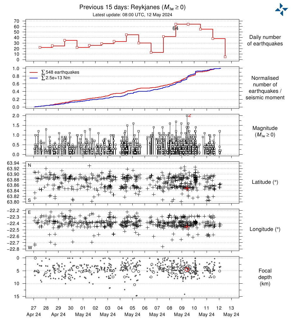 ).
).
Quakes are jumping around Thorbjörn in concentrated sets, maybe getting a little shallower but even that is not clear.
Plate moving -> decompression melt -> intrusion -> ?
Main effect of the intrusion are faults responding up to this moment, just little leaking of magma in them perhaps.
There are so many strike slip faults on the peninsula, pushed up area’s … Many of them buried under lava, right. No wonder it is noisy through the years. It is a dancing skeleton on a tin can roof ha!
Where is the Reykjnes Fault? Anyone got a reference to a map.
Look for the Reykjanes seismic zone. The fault itself is very difficult to discern on the surface. There are echelon faults which are easier to see, especially further east,
Here is roughly the location. In reality it has a bit of a bend, and of course the position depends on depth
Thank you. I’d found lots of references to the Reyljanes Fault Zone but not the fault, itself. Where is Mount Thorbjorn in relation to the fault?
I would place the surface at just south of Thorbjorn. But there is no obvious surface expression. Below is a possible track. You are looking for features with a hint of extension, and possible a bit of east-west displacement, about ten meters since the last eruptions. Lava flows quickly obliterate it. And it is indeed a zone rather than a strict line. Don’t expect the San Andreas here
https://www.usgs.gov/observatories/hvo/news/volcano-watch-playing-wire-upcoming-surveys-reveal-kilaueas-inner-workings
For Hector, it looks like we will get to test some of your theories on Hawaii and Kilauea soon. I had not realised the last survey of this type was done in 1978, that was before Pu’u O’o, I expect things have changed greatly now.
I’m not sure we will get that much more information from these studies. These methods lack the necessary resolution, and the people interpreting the data normally lack perspective on how intrusions behave and would look like, and particularly don’t understand that well the plumbing of Kilauea. But it’s good that USGS does stuff, you never know what you might find.
M 4.7 – ICELAND – 2022-05-28 08:06:18 UTC
Saturday
28.05.2022 08:06:16 64.625 -17.500 8.1 km 4.4 99.0 2.2 km SE of Bárðarbunga
The next eruption from Bárðarbunga or Grímsvötn?
Are these recurring larger quakes from Bardarbunga actually volcanic? Quakes like this were common when the collapse of the caldera was taking place in 2014, and now after seeing Kilauea we know the exact mechanism. Kilauea also had a couple of similar quakes in its other low altitude eruptions, 1 in 1955 and 3 in 1960. They are collapse events along a ring fault.
Maybe Bardarbunga is still collapsing, very incrementally.
The polarity of the moment tensor is reversed compared to quakes during the collapse. That to me is a strong indication that movement is reversed.
With the small disclaimer that I haven’t seen a full moment
tensor solution for this particular quake yet. But for all other quakes it’s the same story. Quakes before and after the eruption have had reversed polarity moment tensors compared with those during the collapse.
I agree. The change in polarity shows Bardarbunga is now inflating, it’s magma chamber grows by pushing up the floor of the caldera like a piston. Similar mechanism to that of Sierra Negra, Rabaul and some little known submarine calderas.
Kilauea instead doesn’t have an active ring fault like many other volcanoes do. At least up to 2018 there was no sign of an active ring fault, I’ve seen catalogs of relocated earthquakes. In 2018 a ring fault was created, but it doesn’t seem like Kilauea is using in a reverse way like Bardarbunga. It has had earthquakes sometimes though, for example the 2021 sill intrusion flared up a portion of the 2018 ring fault.
The following articles I recall were a good read on CLVD earthquakes and volcanoes:
https://agupubs.onlinelibrary.wiley.com/doi/full/10.1029/2012JB009721
https://agupubs.onlinelibrary.wiley.com/doi/full/10.1002/jgrb.50131
Bardarbunga ringfault activity past 365 days.
Credits data and map IMO.

So Sierra Negra is basically what a deglaciated Bardarbunga would be like. Except I guess that Bardarbunga doesn’t erupt much from its actual caldera at all and has got defined rift zones.
The more I look at it the more it seems like Kilauea realistically is a whole bunch of volcanoes combined, there are a lot of things that are really weird about it even compared to Mauna Loa. Maybe it is too easy for eruptions to happen there for the sort of pressures needed to push a caldera back up to happen, so calderas are filled in instead of rebounding.
Bardarbunga erupts from the caldera, last it did so was in 1996.
It was rather short, 32 minutes if I remember correctly, and reached into the realm of a minor VEI-2, but this rather important eruption got lost in the hubbub of Gjálp.
The IMO did though take some nice photos of the column.
I call it important since it heralded what would be coming 18 years later.
Piston uplift of a caldera floor is not so common however. As far as I know, Fernandina, Askja or Piton de La Fournaise are not doing it either. For some reason Bardarbunga has a very well developed ring fault system which allows the caldera floor to rise and fall quite easily. Similar to Sierra Negra.
The Sierra Negra eruption of 2018 is quite interesting just before the eruption there was a Mw 5.4 earthquake that uplifted the caldera floor like a trapdoor, uplifted the west side which is visibly faulted. During the eruption there was a Mw 5.0 that had the inverse effects of the Mw 5.4, slightly closing the trapdoor, a micro-caldera-collapse, the west portion collapsed.
Bardarbunga is much the same, it is also trapdoor like. When it collapsed in 2014 it did so in a trapdoor manner, the side that collapsed was mainly the northeast corner of the caldera, most earthquakes were happening there too. So it is not uncommon for calderas to be asymmetric trap-door like.
https://www.science.org/cms/10.1126/science.aaf8988/asset/f850a011-17c9-450f-9bfb-163d8e591f6b/assets/graphic/353_aaf8988_f1.jpeg
It is likely re-inflation. Very roughly, with an M5 now once a year while they happened once a day during the eruption, over 100 days, Barda will take a century to recover. That is roughly the recurrence time of these eruptions. These numbers are order-of-magnitude only of course! But calderas can also rise because of evolution of the magma chamber. Lower density magma rises, and as it evolves the density drops a bit. This gives a push against the bottom and resurgence, but without requiring new magma. In these cases only part of the caldera will rise
The last event from Bardarbunga that was like Holuhraun was probably the rifting that happened in the 1860s. That began with an eruption southwest in 1862, there was also possibly another rift in the same place as Holuhraun which erupted in the same interval, and an eruption also happened near the first 2 years alter in 1864. the 1862 and 1864 lavas together form Trollahraun, which is supposed to be about 0.5 km3 volume. the Holuhraun II lava was a lot smaller than the 2014 eruption, so total lava probably is less than 1 km3, but the area of rifting was twice as big as there was two dikes. Before that there was I guess Holuhraun I in 1797, but that was not a huge eruption either, much smaller than 2014. So they seem to be more than once a century but the last eruption was fairly large so expect a longer wait. Veidivotn eruptions seem to put Bardy to sleep for a lot longer, several centuries at times. Holuhraun was inbetween a Veidivotn event and a common smaller rift in its absolute scale.
Actually, how deep is the magma chamber at Bardarbunga. I presume it is shallower than the actual diameter of the caldera, as is the case at Kilauea and Sierra Negra, and probably alot of calderas. Grimsvotn has a rather shallow uppermost magma chamber.
The diagrams all portray the magma system of 2014 as being a deep single chamber that fed a dike laterally to Holuhraun. But most basaltic volcanoes seem to have many magma chambers going deeper, especially big ones with rift zones. All that is required is an open hydraulic connection, which can be anything, so the uppermost magma chamber at Bardarbunga need not be at the depth of the dike, or even where the dike came from. If there was an asymmetic subsidence that suggests a wide shallow chamber with a solid hard lid.
Chad, I have those same doubts too. If you look at the earthquake maps I linked above, one possible interpretation would be to place the magma chamber about 3-4 kilometres under the surface, 2.5 km bsl, just under the fault of the northern side side of the caldera. I personally find that much more likely than other common interpretations which place its storage at unusually great depths for a basaltic caldera.
Sierra Negra has the magma chamber 2 km below the surface. Kilauea also has its main magma chamber at this depth, however the East Rift Conduit is at places 3 km below the surface and is likely within the sill complex of the summit too. Piton de la Fournaise has its magma chamber at 200-400 meters above sea level, or about 2 kilometres under the floor of Dolomieu.
One model I saw has magma at a large range of depth underneath Bardarbunga, with the main chamber inside the caldera a 4 km or so. In fact that depicted it as a collection of sills. The top two kilometer of rock may be quite moist because of the ice cap. If you go very deep (15km ?), then there are connections between magma reservoirs at different volcanoes, at least they seem to respond to each others pressure changes. That may be typical for a mid-oceanic spreading zone.
The piston plug is roughly 7km deep, and then you have roughly 3km of magma reservoir under that.
There is though a very small one that is located at 3-4km and that follows the caldera wall, this is the one that erupted in 1996. It was not as far as known involved during Holuhraun/Nornahraun.
Just as during the collapse, mainly at the north- and southside of the caldera.
East and west are not very active.
The reason for that is that it is slowly being pulled apart in the EW direction due to the plate tectonics. Less tension, less earthquakes.
https://twitter.com/Flash43191300/status/1530563066907205632
https://twitter.com/WeatherSarov1/status/1530492800399298561
Volcano Bezymianny eruption in Kamchatka, Russia
May 28, 2022.
50,000ft, so it must have been a sizeable blast.
I overlayed the earthquake map from the article onto google earth. I also overlayed the vents from the last two cycles.
It looks like the majority of the quakes line up with the Sundhnukur crater row and associated fissures, with another cluster on the other side of Thorbjorn and a 3rd to the south of Thorbjorn. I am not convinced the quakes are really linked as a dike, although those that are north of Thorbjorn may lead to something. The area is a rift zone but that doesnt mean the intrusions can only be dikes, ductile crust will be rather hard to fracture in that way especially at depth under pressure. A sill though would be rather expected, following horizontal lines of weakness. After seeing INSAR of sills vs dikes at Kilauea, and also last year, this looks like a sill rather than a dike. IMO also says it is a sill. That doesnt mean it cant turn into a dike and erupt, just that it isnt at that point yet.
The Reykjanes and Krysuvik Fires erupted more evolved lavas than Fagradalsfjall so the magma must have been in the crust for longer. Perhaps we are seeing the start of a new magma reservoir – one that started in 2020?
It is probable, and that was also something speculated at the start of the eruption too.
The difference is not huge though, so what we are watching now at Grindavik is probably a short term precursor to another eruption, which will erupt magma that is stored from at least since 2020 up to now as well as ongoing feed. Krysuvik probably will behave exactly the same way, stored magms as well as new. Brennisteinsfjoll erupts slowly for a long time like last year, will be interesting to see if it erupts more directly first time or if a few intrusions are needed to break through.
Not sure if it is real but there is an upward trend in the Pahala quakes for this week. Also more quakes of the same depth inbetween Pahala and Kilauea than there have been for a while.
Interesting news from Iceland, whilst we are looking at tourist volcanoes in Reykjanes… Askja is starting to look a bit dodgier. 15.75in (40cm) of land uplift since August at 2km depth.
Yeah, just saw that myself. I remember they couldn’t get any actual data on inflation for months due to the winter making it inaccessible. So that made me wonder if it’s the case that it’s been steadily inflating over the past months or whether it inflated very quickly and has now gotten stuck at around 40cm.
Either way, it isn’t a good sign for the countries in the North Atlantic.
Askja should be pretty harmless, 1875 was a big event and pretty recent, most of its eruptions are pretty small. Might not be a good idea to swim in Viti crater though, or in Oskjuvatn for that matter.
If there is a big eruption to come from this it is probably going to be later in the sequence, the eruptions in 1875 really began in 1873 with basaltic fissures along the ring fault, then along a major rift to the north that set off a caldera collapse. The rhyolite explosive stage was part of the collapse but not big enough to cause it. Apparently the caldera only stopped collapsing when the eruptions in the 1920s happened.
But yeah, 40 cm in a few months, something will happen here 🙂
GeologyHub viewer?
I like that channel!
Next article is indeed about Askja.
I wanted to clear up a few misconceptions about that.
So, weekend is saved for those who suffer from lustful feelings in regards of remote Icelandic volcanoes of stupendous nature. 🙂
The Krisuvik Highpass plot is showing some interesting readings
A pick up in activity at KRI often preceded a pick up in activity at Geldingadalir in 2021. Be interesting to see if this is a precursor to something further west.
The Reykjanes webcam is a little jumpy for the weather conditions.
https://www.livefromiceland.is/webcams/reykjanes
Hunga Tonga has been confirmed, more or less, as a 6, albeit a lowish 6. I still think it is an underestimation.
Interestingly, the harvests of good to excellent crops worldwide do seem to be down by quite considerable figures, despite the ascent to the solar maximum. Something consistent with large eruptions.
Anecdotally, early summer in the UK seems somewhat cooler than normal. Normally, around this time of year I can go around in evening in shorts and t-shirt. This year, a jumper is required.
South Africa has experienced snowfall already. Interesting to see what the SH winter brings.
It is cool in the UK at the moment. Meant to warm up in a few days. But I am hesitant to invoke Hunga Tonga. A low VEI-6 should only have marginal impact on climate, and in this case the ash in the atmosphere was lower (water intercepted some). As a southern eruption, the effect in the northern hemisphere should be further reduced. And finally, we have la nina conditions at them moment and these have more effect on the weather. So we should keep an eye on it but look out for impact in the south rather than the north.
It is pretty cold, as my annecdotal experience.
On a global basis, latest snapshot as seen by the GFS
And SST
SH showing a slight -.1C anomaly today. It’s stupendously difficult to attach daily fluctuations to a volcanic eruption, especially one that wasn’t proposed to have much of a climate impact. There’s so much natural variability in the daily climate to begin with, and there will always be some up and down movement in the global temp anomalies with a bias toward more warm anomalies of course.
If a persistent slight negative to flat anomaly persists in the SH for the remainder of the year perhaps it could be linked.
It is here good to remember that with the glorious exception of me and Albert, the eruption was until now believed to be much smaller by everyone.
Now that it turned out that me and Albert pretty much hit the proverbial nail, it is easier to believe that there might be a minor influence.
Frankly, I was right there with you guys. I couldn’t conceive of HTHH being anything less than a solid 5, high water content or otherwise. It just seems like the generally low SO2 figure will hold back a greater climate impact, and a small one is more difficult to discern from normal variation.
But yes, you and Albert nailed this one. If anything, conservatively.
There seems to be an ashlayer on the latest set of ISS photos, I am though awaiting confirmation.
But, to the naked eye it looked very much like the post-Pinatubo layer.
Here it has been an unusually cold and rainy spring compared to the last decade, but that is anecdotal since it is only local data.
In other news, Svalbard is melting at record speed due to record heatwave…
If any volcanic winter takes place, it’s subject to be minor. Tonga as far as we know, didn’t throw a lot SO2 in the atmosphere which is the main driver of volcanic winter. Any cooling and long-term haze would likely be caused by small ash particles which has exciting prospects for further insight in to volcanic winter mechanisms
Do we have a final figure on the SO2 release? I know the initial estimate was about 1/40th the amount that Pinatubo released to the stratosphere.
I do not think that SO2 will be the problem, instead I can see a minor volcanic cooling being caused by having very fine grained ash lofted 50km…
Will be interesting to see the yearly world stats when they come out.
Definitely! Excited to find out. HTHH has been the gift that keeps on giving as more and more info becomes clear.
Thanks for the incredible series of articles on it.
Taal is producing 2500 m high steam plumes with low gas emissions, for reference, these steam plumes are higher than the ones when Taal was producing high levels of volcanic gas. This likely means that there is more heat and magma but far less ventilation. The latest shot of LICs data show inflation on the eastern rim of the caldera but I am skeptical to say the least, nevertheless more eruptions from Taal seem likely
One of Galileos Spacecrafts closest views of the Ionian lava lake Pele Patera on Jupiters Moon IO. While similar to Earths basalts, the scale of the lava lake volcanism is litteraly Unearthly! Thats a lava lake thats 60 kilometers long. Probaly is a hole into IO s inner magma ocean. I Hopes for more spaceprobes sent to Jupiters Moon IO soon ..
The lake fountains is gigantic in this lake If you use the scale bar..Thermal image, But the space – probes cameras Maybe over exposed by thermal radiation.
One of IO s more active lava lakes. Loki Patera is much bigger 230 km wide its a lava Sea that only overturns every 2 th Earth years ( mostly woud look like dark grey shiney plain ) Pele is a much more active surface with constant fountains and overturns.
But the violent basaltic plinian fountains on IO ( outbursts ) is the best way to measure IO s magma temperatures rather than lava lakes that mostly haves a thin crust on them ..
Unearthly volcanism in scale: Dallas-Fort Worth would just about fit Pele’s Lava Lake, If you could stand on the rim, the other side would be beyond the horizon. 1280 C was measured from Pele Patera
Bit of movement on the Húsavík-Flatey Fault today:
Source: https://en.vedur.is/earthquakes-and-volcanism/earthquakes/tjornes-small/
https://www.google.com/amp/s/www.sciencealert.com/scientists-might-have-figured-out-the-source-of-the-world-s-most-active-volcano/amp
Found this article that suggests that a deeper magma chamber is responsible for the formation of Kīlauea. Seems as if, according to the study (which I hadn’t read yet and only read the news article on it), fractional crystallization is only a shallow feature to the Kīlauea magmatic system. I thought it is quite interesting.
Wow, 90 km deep. That is so far down though it is hard to imagine them all staying separate, it is as far down as the entire island is wide.
It does also sound like the volumes of magma that Hawaiian volcanoes store is quite biblical, with magma storage going from 5 km depth all the way down to 90 km. Really at this point it seemsbetter to think of the Big Island as a single volcano with multiple vents.
160 km wide and much wider at its submarine base that yeilds almost 300 km If you go from Puna Ridge to Hualalai – Submarine tip
In other words, less than Grimsvötn at 450km3… 😉
Grimsvötn is not 450 km wide…
Big Island is 300 km wide from its submarine base at haves perhaps around
350 000 – 400 000 km3 is materials that have emerged most of that in much less than one million years
Hawaii sits in a much deeper ocean and on a much faster moving seafloor than Iceland Thats why Hawaii is smaller than Iceland, althrough the induvidual Hawaii Volcanoes Dwarfs anything Icelandic
My fault, I misread. I thought you stated that there was 300km3 of magma in the reservoir.
There is probably more than 450 km3 of magma in the deep rift of Kilaues, which is probably the same thing as the magma reservoir under Grimsvotn you speak of. USGS doesnt really count this as such though, because it is olivine cumulate crystals not liquid, and that is likely also the case in Iceland.
I recall a study that showed the gravity around Icelabd abd Grimsvotn had a positive anomaly, like it was very dense. That would probably be because a lot of magma that was under it was drained off to feed Laki. The uppermost chamber seems to have been spared.
The melt grade is unusually high at Grimsvötn, probably due to the good clip of throughput and openended “design” of the system at the bottom.
But, obviously there is still a fair bit of crystals in it.
Looking at the data it appears Vatnajokull and the large complex of volcanoes there could be similar in structure to Hawaii, where each volcano has got a separate upper system but deeper down the boundaries blur or disappear altogether. I recall that the crust underneath Vatnajokull is thicker than the distance that separates Grimsvotn and Bardarbunga, and they do seem to interact. Laki also happened, the first time in about 5000 years an eruption in that area had occurred, and in the past millennium only one rifting event has happened at Veidivotn where typically there would be at least 3. Not sure it is completely correct to call them a single volcano (same at Hawaii for that matter) but they are not independant it seems.
50 kilometers thick crust in Vatnajökull.. its all underplating by the Hotspot as well as crustal thickening from magmatism
Opps, I kinda misread the article wrong – fractional crystallization is not a surface feature of Kīlauea according to the article but instead, before this, it was assumed that fractional crystallization is a shallow feature.
Widely felt quake in the UK
https://twitter.com/MetJam_/status/1531291650965884928
What are they up to in Oldbury? I’m guessing human activity but its a bit early for the rush hour, etc.
It’s on the margin of the London – Brabant Massif, possibly the Welsh Borderland fault system.
https://en.wikipedia.org/wiki/London-Brabant_Massif
Sorry This one is for the Swedes in this forum.
SR’s “Vetenskapsradion på Djupet” latest podcast is about the eruption of Mount Pelée on Martinique, and it features an unique interview from 1939 with one of the few survivors of this VEI4 eruption, a Swedish sailor on a ship in the bay.
I’ pretty sure I have read here on the café about this eruption, but neither I or Google can find it now. So here’s the wikipedia piece on it. https://en.wikipedia.org/wiki/1902_eruption_of_Mount_Pel%C3%A9e
Anyway, here’s the podcast in Swedish:
https://sverigesradio.se/avsnitt/carl-overlevde-1900-talets-dodligaste-vulkanutbrott
Ps.
The podcast also features a new Swedish volcano profile, a professor at UU. A contender to professor Bödvarssons monopoly on volcano related media events?
Would that be Erik Sturkell? But I thought he was in Chalmers…
Nope, not Erik Sturkell, but Valentin Troll.
yes, Valentin Troll (a fantastic name for a professor in petrology, he must be hearing Grieg a lot)
He has a quite busy volcano-themed youtube channel. Published this on the LaPalma eruption just a few days ago.
Ah, Valentin Troll has become a professor.
Must remember to congratulate him one day.
https://photojournal.jpl.nasa.gov/tiff/PIA02567.tif
Photos, Jupiters Moon s IO s largest basalt lava flow fields .. the biggest is Lei Kung Fluctus flow fields thats as large as Northen Europe, its well over 1000 km long while the Amirani flow field is 500 km long and Prometheous flow fields is 110 km long. These large Ionian flow fields seems to all be well insulated tube feed pahoehoe lava flows Thats emplaced slowly over decades…
While similar to Puu Oo s lava fields in eruption style .. the scale of IO s lava flow fields Are Unearthly! On IO we wittness and can observe basaltic magmatic activity that woud be disasterous on Earth.. Lei Kung Fluctus approach the size of some flood basalts units. The eruption rates of these Ionian pahoehoe must be higher than Earthly examples as well
The Beautful color shades are because of sulfur snow that freezes out from the basaltic vents or frozen gases from the lava flows .. themselves that slowly buries older Ionian sillicate flows under sulfurious snow.
IO s lava tubes must be the longest active basaltic lava tubes in the solar system,
The Amirani and Prometheus lava flows are each continuously growing at about 100 m3/s or so, from lava lake overflows. Many other Ionian volcanoes erupt at probably similar rates, feeding slowly expanding lava flows, or filling the paterae with huge lava lakes. It is an incredibly powerful volcanism. Strangely even at these high rates the lava is still pahoehoe, maybe the lava is more fluid than Earth tholeiite basalts.
I think 450 m3 per second is the estimate for the Prometheous lava flow field on IO.. thats rather high compared to Puu Oo .. and yet its pahoehoe so yes the viscosity is likey very low
An 1400 km3 magma chamber was tought to supply the 1979 – 1990 s lava field. The Prometheous lava flow is Probaly is twice as large .. more than 20 years later
Perhaps the eruption rate is spread out feed by a large vent Fissure .. that woud lower the apparently eruption rate.
Yes Ionian lavas have low viscosity, very low viscosity, it haves only a few shield volcanoes, rest is calderas with lava plains.. Perhaps the sillicate lavas are so hot and fluid they dont form volcanic piles like on Earth
It coud also be that Ionian volcanoes haves similar viscosity To Kilaūea, But erupt as massive single vents that pour for decades .. building up lava plains .. rather than edifices .. acually similar to Earths flood basalts that does not form edifices either ..
The temperatures of Ionian lavas have been measured at 1280 C at Pele Patera by Galileo Probe data .. and are almost certainly hotter than that, at 1270 C To 1300 C you gets a viscosity as low as Kilaūea Iki and Fagradalshraun near vent. Ionian lavas haves low viscosity but hard to say How low it is or How hot it is .. But over 1300 C is possible
Estimates of 1650 C To 1700 C from 1997 Galileo Data are probaly very incorrect that woud make the lava as fluid as water and as bright for the eye as and it woud look like liquid sunlight. .. lava cools quickly on the surface as well Making it hard to read temperatures
Vaccum is a very poor conduction of heat so Ionian basalt lava flows cools more slowly on the surface than Earthly does and thats why they can flow further
IO is basicaly an inferno .. planet .. the real world Mustafar.. and is my favorite place in the solar system 🙂
Ionian sillicate lavas haves low viscosity.. probaly .. as low or lower than Earths lowest viscosity sillicate lavas in Hawaii
If Io produces superheated basalt over 1300 C it coud be as fluid as Lengai .. Althrough still not liquid iron fluid like Komatites
IO coud produce 1550 C Komatites as well but that needs A specialized SpaceProbe like IO Volcano Observer to photograph temperatures in higher resolutions than Galileo did. Water and Titanium are good at blockning IO s radiation.. and any New probe should have that around its brain. Juno haves a titanium Jacket around its electronics and should fare relativly good against Jupiters radiation.
Seriously needs IO Volcano Observer to be built with .. HighRise image capacity
At current we know that IO erupts High temperature sillicate basalts, based from temperatures and from spectrometer of Pillan Patera 1997 pyroclasts that found olivine and ortopyroxene.. IO is pretty iron rich in composition as a whole ( so the lavas coud be even more mafic than terestrial ones ) IO is probaly a like a smaller Mercury .. with a smaller core with the same metal rich stone mantle
The violent Ionian basaltic plinian lava fountain eruptions are the best way to measure temperatures directly of the lava fountains there Galileo got up to 1750 C .. for Pillan Patera 1997 But its data error in temperatures estimates
Still its possible that some of Ionian lavas coud be Komatites.. They seem very fluid .. but my Card is on Hot Thoelitic Basalt like Lunar Mare
Keeping the thread below this one.. sadley Peles gigantic lava lake left behind above
Hopes Juno visits IO soon .. Juno’s a more advanced probe than Galileo, and unlike Voyager, it’s in orbit around the system. They’ve saved IO for last, although it’s also ‘hardened with titanium ‘ more than its’ predecessors. Hopefully, they’ll get several passes to survey the volcanic world in detail in 2024
IO is basicaly the real world Mustafar from Star Wars .. Jupiters Darth Vader Moon .. and its becomming my top favorite volcanic place outside Hawaii and Iceland. Hopes for IO Volcano Observer to be built soon
I wish Io Volcano Obsever came true. Io is a really unique place, possibly the only other location in the Solar System with active silicate volcanism. Venus may have been napping for 450 million years, and Mars for a few tens of millions.
Io’s magmas likely have a different composition to those of Earth, Mars, Venus, and the Moon. I have not read much about this, but there are some obvious clues. First the very high sulphur content of the magma, which paints the ground red near the lava lakes and lava channels. Then there is the extremely shallow slopes of Ionian volcanoes. Technically Ionian volcanoes have a lava lake and a slight outward slope, so they could be compared to shield volcanoes, however they have little prominence being more like plain-shields. Perhaps a very low viscosity is responsible for that. Finally Ionian volcanoes seem to make only pahoehoe lava, as far as we’ve seen, obviously there is a lot of surface that has not been mapped in detail. This contrasts with Mars and Venus which are almost entirely aa lava. It also contrasts with Earth which would most likely make aa if it erupted at the very high rates of Ionian volcanoes. So if I had to guess I would say Ionian lavas have a different composition and are possibly more fluid than those of Earth. This composition is probably unique to Io, and by this I mean I doubt it is present in the Earth, Mars, or Venus.
Probaly is a high iron, high magnesium picrite basalt Thats IO produces that have lots of olivine as well and a very high sulfur content .. a sillicate composition unique to IO
But coud be something as hot as something that resembles Iron slag as well
You would expect low iron but high CO2 and water content, based on typical composition of the moons of Jupiter
IO is very iron rich also it formed very close to Jupiter where it was very hot in Hadean Era IO haves the least ammounts of water of any known body in the solar system as the hot primodial Jupiter boiled everything dry there .. its also boiled dry by Tidal Heating
Albert do IO erupt Komatites on its surface? Or is it just a very mafic basalt? Your opinion? Some pixels in Galileo from Pillan Patera lava flows show well above 1300 C
It is not ‘very iron rich’. It has a much lower fraction of iron than Earth, and even Mars, and is close to that of the Moon which has only a small core. However, Io is more iron-rich than other moons of Jupiter. If the results pointing at a global magma ocean, 50 km deep in the mantle, are correct, then you would expect the iron to have dropped to the bottom. There will be much more water in Io than on Earth (relatively) because of where it formed. Earth is bone dry, and all the water is at or near the surface. Mars is more water rich. Io should continue that trend. Some may have boiled off but only near the surface.
Sulfur is the main magmatic gas in IO s sillicate lavas not water ..Ionian Basalts seems extremely rich in sulfur .. as Hector say
Seems much more sulfur rich than any of Earths Basalts
On IO looks like Basalt lava flows and Sulfur snow layers gets buried togther and gets recycled into IO s inner magma ocean where they act as magmatic gas driver
IO erupts hot liquid sillicate magmas thats rich in sulfur gas .. But hard to say exactly about IO s lava composition.. Hector coud be right .. its a sillicate composition unique to IO and it coud also be Komatites that IO is erupting
Yeah.. better to Put this on the VC Bar .. should have tought of that before.. But I do love IO ! 😃
Still I think the Typical Ionian lava is rather similar to Halema’uma’u and Fagradalshraun close vent in viscosity. .. and thats still very low viscosity and runny .. while viscosity is similar to very Hot Basaltic melts on Earth .. the lava production is off the charts on IO and explains the larger lava flows and gigantic lava lakes
Pillan Patera 1997 was a basaltic plinian eruption that produced 58 km3 of fountain feed lava flows ( must have been a hell of a sight! ) it did fast flood type Aa .. Galileo closeup showed Aa with huge crust rafts like the lava flow near Krafla .. it woud be an insane sight .. Pillan Patera glowing fountains where perhaps 15 km tall
Also the Pillan Patera caldera was filled by lava with massive 2 kilometers high lava falls Falling into the pit .. whos floor became covered in a Rootless lava lake .. perhaps 20 km3 of lava flowed into the Patera pit Dwarfs any historical lava flows on Earth ( GIF ) animation
I wants an IO Hirise probe with its electronics brain encased in titanium and water
Yes IO is my favorite object in the solar system .. and soon Juno will start its flybys
https://www.researchgate.net/publication/356631999/figure/fig8/AS:1095686577766400@1638243445285/Location-of-emission-from-Pillan-Patera-presented-here-on-2015-March-08-in-the-context.ppm
Pillan Patera have had many large VEI 6 basaltic plinian outbrusts since then soo the entire arera is unregonicable today .. Perhaps the Pillan Patera have been competely filled by lava flows by now
Looks like the eruption of 1997 was maybe even on the smaller end, especially compared to what happened there in 2015. You might be right in it being completely unrecognisable today from what Galileo observed in the turn of the century.
Yes .. insane eruptions.. and 2015 seemed to be a very busy year around Pillan Patera. Perhaps 200 to 300 km3 of basalt produced in year 2015 in these lava flood fountain eruptions put togther
The Pillan Patera itself must be totaly filled by lava at this stage, These are insane eruptions that are like gigantic Mauna Ulu lava fountains .. and produce 50 to 80 km3 in one go .. in just a few days like Pillan Did 58 km3 basalt in 1997 in just a few days
Kind of luckly that Reykjanes cannot go Ionian 🙂
I wonder Whats IO s very largest fast eruption capacity ability 🤔
Closeup of the Ionian Amirani basaltic lava flow around 500 kilometers long, the dark spots are fresh breakouts thats not yet covered by sulfur frosts… older Ionian basalt lava flows gets competely covered by sulfur snow thats the magmatic gas that freezes out from the sillicate eruption vents
In the bottom left you can appreciate the crusted lava lake, enveloped in an halo of red sulphur, recently degassed from the magmas rising in the lake. It is connected to the active flow by a lava channel that is also flanked by reddish sulphur. Prometheus, Culann, Isumm are also similar, with crusted lava lakes feeding large flow fields through channels, which are sometimes collapsed or eroded into the ground. The so called graben of Pele might also be some sort of old channel no longer being used. See Isumm patera which feeds the gigantic Lei Kung Fluctus through an active channel/tube system:
Some flood basalts are not fast eruptions from fissures but actually consist of continuous overflowing from lava lake. A large portion of the lava erupted in Venus, and Mars, probably the larger portion, were erupted this way, as rapidly overflowing lava lakes which fed flows several hundred kilometres long, making very extensive shields, like Maat Mons in Venus, or Olympus Mons in Mars.
Yes as well as the basalt flood plains on IO Juno thats gets buried by sulfur snow
Juno will soon pass by IO in 2024
Yes volcanism is insane on IO as tidal heating is pumped in .. Earths current volcanoes are nothing compared to IO s wast eruptions
Prometheus, with the overflowing lava lake in the right and the growing lava flow to the left, blowing away the layer of frozen sulphur, revealed by the white jets emanating from the margins of the active flow:
Ionian lavas coud be hot enough to resemble flows of liquid slag.. and on IO s much lower gravity souch flows woud be much thicker in height than on Earth, Making it even harder to guess viscosity from Galileo Satelite imagery, in words Ionian lavas coud be really hot and primitive .. and primodial.
Earth lavas can look like that too .. specialy If its degassed .. its all the gas that makes the fluid Earth h lavas in Halema’uma’u look frothy and rough.. yet superfluid and shiney in motion … Had for example Halema’uma’u had very little gas .. it too may look like smooth liquid slag.. the gas poor lavas at lava pour furnace experiments .. does look like liquid slag
Ionian lavas are boiling of gas .. and probaly is puffy and swollen as it erupts
Althrough If IO s lavas are Komatite superfluid, that woud require insane eruption rates to form souch long lava flows
My bet .. is on Superheated Basalts .. ( 1270 – 1350 C ) for Ionian lavas .. it fit the flows surface textures better.
Here is some Galileo Photos from Ionian lava flows from Zamama Volcano that haves the typical fractal pahoehoe texture .. looks very fluid for soure, Juno will visit in 2024
IO is soooo much like Mustafar…
“Its over Anakin!! I have the high Ground!!”
I always imagines a little anakin and obiwan duelling among IO s lava fountains
Interesting that the Reykjanes Peninsula has quietened down just as the TFZ picks up. Does this mean that most of the swarm near Grindavík has been mostly tectonic all along – the crust accommodating something going on nearer the mantle plume?
https://en.vedur.is/earthquakes-and-volcanism/earthquakes/reykjanespeninsula/
https://en.vedur.is/earthquakes-and-volcanism/earthquakes/tjornes-small/
Okay, can we keep the IO thread in one comment tree please?
Right now it is plastering all over the place.
Yeah, this is a serious IO-demic here. The posts must all be quarantined to the VC Bar.
(I do not recommend quarantining at a bar during an epidemic in real-life. If there is actually a pandemic like COVID-19, staying home is probably the best option if you have one. I had it once and it ain’t good on you, especially if you had 2 vaccinations already under your belt. You can only go out if you are clear of any dangerous, contagious disease.)
I’m happy as long as any Ionization is kept to a single comment thread.
It is when we have 4 or more of them going at the same time I get a headache.
(If people just kept to spanking their monkey we would not get monkey pox… seriously, what was wrong with that dude…)
That earns you an award for use of the most inventive language. Iotastic!
I am a most innocent Swede, so I was quite astounded when I learned that there are Monkeys of the Night…
Myself exiled on IO for my ”mischief” done on Earth ..
https://m.youtube.com/watch?v=CXswFo_twN0
https://m.youtube.com/watch?v=wyYgdVGOPWo
Latest video of Etnas current lava flows
Nice Aa lava .. really shows what temperatures does to a lava, althrough these thick Aa flows store heat well so will continue to advance as long as the vent is active upslope. Turns to Aa almost instantly as it leaves the vents.. Etnas lavas while lower in sillica than Hawaii are cooler and more viscous because of lower temperatures
Not sure if it is cooler, just that Etna has a lot more water in its magma, so to get it effusive the magma needs to degas and that also means it needs to sit for a while, letting it cool. Probably a lot of the lava we see erupt there quietly is stagnant lava within the conduit that gets pushed out in advance of a paroxysm. The most powerful paroxysms erupt at the same temperature as Hawaii and Iceland, 1150-1200 C, and sometimes have more fluid flows. I would not be surprised if an actual lava lake existed before 1669.
The lava pouring from that vent looks more of a pahoehoe texture so perhaps there is some hotter stuff erupting now compared to last week.
The deep magma in Etna is probaly as fluid as Masaya.. Etna is low in sillica and a bit over 1100 C and likley much hotter deeper down.
Whats comming out here is clearly not as fluid as Hawaii or Fagradals .. it turns to Aa texture already at the vent it haves that texture so the viscosity is higher. Quickly turns into Aa lava or can be called a ”rough pahoehoe” just at the vent
Had it be Kilaūea..tube vent it woud have been ”flowing like liquid iron” with a shiney grey aluminium skinn
Etna haves very low sillica content being an alkaline magma, an Etna lava heated to over 1200 C woud probaly be extremely fluid
But Etnas eruption temperatures are 1070 C to 1140 C .. temperatures affect sillica chain polymerisation alot and that lower temperatures is What does the diffirence between Etna and Hawaii
Etna is low in sillica .. so low that even its most fluid lava flows have a rather glossy look .. perhaps too little sillica to form that nice sillica shine on crust. Nyiragongo is as fluid as Hawaii .. But it does not have Hawaiis shiney aluminium looking lava skinns either
Rock is a good insulator.. Etnas Edifice acts as a Huge kiln furnace and magma must be heating its sourroundings and specialy now with a supply thats around 50 to 70 million cubic meters a year. If there is any cooling .. then its in the upper conduit But groundwater coud make cooling more efficent as it circulate away heat
And I can Only imagine Mauna Loas heat stoorage capacity with its enormously Giant edifice mass, Mauna Loa sourely had coarse grained regions in its hotter depths encasing its magma chambers .. Big Island of Hawaii is basicaly the same mass of a very small Dwarf Planet ..
I remember a discussion on VC a while back regarding the two large lobes/blobs of material deep within Earth’s mantle (the large low-shear velocity provinces, LLSVPs), which scientists at Arizona State University posits may be left over pieces of the penultimate Theia collision. It is well known that blobs of material of different composition and different density exists under Africa and the EARZ and parts of southern Europe, while a second blob is beneath the Pacific and the Hawaiian mantle plume.
As I recall, Albert echoed the “standard” explanation/theory that it’s mostly tectonic processes that form (and maintain?) the blobs…but then again only the Africa blob has chemical signatures of subducted surface crust while the Pacific blob largely does not. Anyway, I don’t recall if we ever came to anything close to a conclusion on why these two blobs near the mantle have different chemical compositions, and I was wondering if there are any further comments that I missed?
One of the possibilities is a compromise….the Pacific blob is comprised of “virgin” dense, post-Theia impact material …whereas tectonics have chemically contaminated a similar blob under Africa. So while both blobs originated from the same Theia collision which produced material that sank into the mantle as Earth cooled, over time, the African blob has chemically evolved while the Pacific blob is pretty much the same.
https://www.sciencealert.com/two-weird-blobs-deep-inside-earth-are-surprisingly-different
To be honest, I do not think they are a over-time feature but rather two blobs that are very unstable. I have heard (even though not on the news article here) that the African LLSVP actually rose in recent geological time, causing a bit more volcanism in Africa and pushing it. Matter of fact, the study states that the African LLSVP is more unstable than the Pacific LLSVP.
I pretty much put that up there, well… just because why not invoke a sort of discussion here so that we could learn. (PS couldn’t get the PDF because it costs $32.00.)
I’ve also read that the blobs are not stable…but the various agglomerations and fragmentations have remained largely at depth (except when feeding into a deep mantle plume or when a rift opens).
In the case of the African blob, tectonics in the form of subduction and/or convection currents can explain a lot as far as where the blob’s “root” source of new/reinforcing material is, however I wonder how the Pacific blob, in the absence of subducted crust maintains it’s integrity? The only subduction surrounding the Pacific blob is well outside it’s periphery, where the Pacific plate (or micro plate) gets thrust under the continents.
But, that would put the bulk of “new” blob material under the continents, and not under the center of the Pacific plate where the blob is currently located?
So, while we have two blobs with somewhat similar characteristics, they seem to differ in how they sustain themselves.
Anyway, just a few thoughts and maybe (as you said) an opportunity for some further learning?
Thing is we don’t know exactly how old they are, but the fact they’re mostly antipodal I think is significant.
Every study I’ve seen referring to them shows strong mantle plumes on the cusp or edge of these LLSVP zones and within mostly strong ocean basaltic hotspots also. The difference is in Africa where you have continental rifting, and having a continent above most of the plume regardless changes the signature and trends towards collection of magma in the crust and more volatile eruptions.
They are definitely a zone of higher heat flow.
A post is actually in preparation on this! There is a lot we don’t know. A relation to Theia seems less likely but is not excluded
Ooh, can’t wait for this one! Great topic!
Most of Theia was competely vaporized and melted and mixed into Earths interior .. these blobs are Not theia pieces .. But rather just very hot zones in lower mantle
This is very interesting. I was aware of the LLSVP’s but in my headcanon always just believed them to be the “slab graveyards” of long subducted crust going back to Rodinia, but I didn’t realize they had differing chemical compositions. That certainly is curious.
Is there any natural process that could cause such an anomaly? If not (assuming too it’s not that simple to determine), that does point toward the Theia hypothesis, no?
Fascinating stuff, thanks for sharing.
Not sure where the African blob is but there is evidence of subduction in Africa from ophiolite inclusions in diamonds. It was in one of the BBC’s “Rise of the Continents” series.
LLSVPs may not be big blobs but bundles of smaller blobs.
Source: https://hal.archives-ouvertes.fr/hal-03024568/file/Davaille_Romanowicz_Tectonics_FINAL_nomarks.pdf
https://youtu.be/QxIWDmmqZzY
https://www.theatlantic.com/technology/archive/2022/05/justin-bieber-beatles-one-direction-screaming-fan/629845/
Now I have the mental image of Albert rocking away to Justin Bieber…
My head is spinning 🙂
So is mine
It looks like Svartsengi has calmed down, the recent intrusion was part of a larger recharge event. That is good for Grindavik now but probably also means when there is an eruption there will be a lot of stored magma, it will be very fast and high eruption rate.
Chad, you’re definitely the right person for me to ask.
With regards to Icelandic volcanic systems (or really just in general I suppose), what dictates whether some systems erupt high volume / high flow, or the opposite?
In learning about Reykjanes volcanism and its different systems, I’ve seen it mentioned that some of them will be much larger / faster events than others (I think Hengill was one); what is the reason for this? Doesn’t it always depend on the size of the intrusion and or the amount of activated / reactivated magma down below?
Does it have to do with the crust overlying magma storage in how well a dike / intrusion is able to propagate and establish a large conduit? Or does it have more to do with the system’s existing plumbing being conducive to a faster event?
Any details would be much appreciated! This is something that confuses me at a granular level of how this differs from system to system.
IE why one system produces a larger or faster eruption relative to another. I would’ve thought that’s mainly just dictated by the size of an intrusion and / or the amount of pressure. But that’s certainly too simplistic a take.
It is a function of the diameter of the conduit, the viscosity, the volatile content and the pressure gradient with depth. Note that it is not the same as the height of the fountains. High fountains can occur at low flow rates and low fountains may come from high flow rates. The length of a fissure is important especially if magma had pooled close to the surface
I have spent a lot of time looking into the volcanoes in Reykjanes and why they erupt differently. I’ve reached some conclusions. There are basically two contrasting styles in Reykjanes, fast versus slow. Fast eruptions consist of long fissures that produce a curtain of fire (row of fountains), and erupt very high eruption rates, these are not necessarily bigger in volume, and in fact it may be the other way around. Slow eruptions produce very low sustained effusion rates from a short fissure or a singular vent, we saw this at Fagradalsfjall, they can be small, however in some cases these eruptions can go on, for possibly years or decades, making enormous piles of lava in the form of shields.
The fast eruptions seem to be correlated with sill complexes. For example Thorbjorn and the Svartsengi geothermal area has been affected by a series of sill intrusions, three in 2020, and one this year. Svartsengi is also one of the locations with fast intense eruptions. Another location of fast eruptions is Hengill which must also have a sill complex because it has erupted rhyolite, rhyolite evolves in prolonged storage and sills are needed for this. The remaining 2 locations are Krysuvik, and the Stampar fissure system where the Reykjanes geothermal plant is located. Both these locations coincide with high heat flow, areas of high temperature hydrothermal systems. Possibly these areas are being supplied heat from complexes of shallow intrusions, same way it happens with the Svartsengi geothermal area.
That is why I would invoke the plumping, these four locations have magma storage in the shallow crust that can drive fast, intense eruptions. In between these four systems the eruptions are slow and seem to feed directly from the magma being supplied from elsewhere, the mantle, or the mid-ocean ridge.
Would be interesting to consider if the presence of magma storage like this would qualify these other systems as central volcanoes. They lack nearly all the other traits, but then Hengill also has not got every trait either, it has some minor silicics but no caldera or evidence of one. Apparently the volcanoes under Langjokull
Come to think of it, Grimsvotn and Bardarbunga dont either, they have calderas but no silicic rocks, unless you consider the entire fissure swarm to be the volcano then there is some on the outskirts. Technically speaking also this definition would mean none of the active Hawaiian or Galapagos volcanoes are central volcanoes either… Central volcano is just the point that magma rises into, and it would appear evident that dikes even in rifts like Iceland actually do have a horizonral beginning and and, rather than simply rising vertically only. So even rift zones like those on Reykjanes are ‘central volcanoes’.
The volcanoes under Langjokull apparently have calderas but I couldnt see the structure in the glacial bedrock tomography, looks more like a coincidental structure.
I’ve reached the conclusion that a volcano with sills is a central volcano. But that is perhaps more of a way that I classify volcanoes, in reality the definition of a central volcano probably varies. Martian and Venusian volcanoes consist of sill intrusions which rotate into cone sheets and radial dikes, to me this is the definition of a central volcano, a volcano which is the center, with system of radiating sills, cone sheets and dikes extending all around it up three thousand kilometres away (this is is the typical radius of a Martian intrusion swarm). So to some degree it could be considered that Stampar, Svartsengi, Krysuvik and Hengill are central volcanoes, but not as developed as other systems. For example Askja has a much higher degree of development with a magma chamber that can collapse, and cone sheet intrusions surrounding the magma chamber opening circumferential fissures. Svartsengi would be a weaker central volcano, without magma chamber, and where sills do not rotate into cone sheets or radial dikes, it only displays simple linear vertical dikes which probably started as dikes, not as sills. Thus the central volcano is somewhat invisible at the surface, only reveals itself to those who can see beyond, and realize that subtle signs, like a different eruption style or a higher heat flow can be indicative of a shallow sill system hiding underground.
Might add a 3rd type, because some of the ‘slow’ eruptions seem to have been episodic. So the long term rate is low but actual eruptions are with higher rate, though not as much as a curtain of fire. The eruptions of Hvammahraun from Brennisteinsfjoll in the mid 900s (about 950-960) were like this, not lava floods but fast enough to make longer a’a flows that went as far as the ocean and buried a significant area. Perhaps was very similar to how Fagradalshraun was behaving in July and August on a larger scale. Hvammahraun was probably the biggest single eruption of the last cycle, likely well over 1 km3, would have been quite impressive to see.
The two eruptions that created the Husfellsbruni lava field also seem to have been similar. One if them was probably around the end of the 10th century, 990 or so, the other was around 1200 AD. The first might also have been from a different system called Blafjoll which also erupted in 1000 AD but that might be the same system as Brennisteinsfjoll, its confusing…
Thanks for sharing your thoughts Héctor! Interesting.
I wonder about the influence of the oblique rift on the two styles you mention. In particular the slow style. In the dyke forming stage of the Fagradals eruption, the eathquakes development through time seemed to have several dead ends (north and south of the spot where the magma eventually surfaced.
Looking at geomorphological structures at the peninsula, it stands out there are numerous faults. The faults are weak spots. I can imagine, magma that normally wouldn’t get a chance to get to the surface because of lack of pressure, finds an easier path in area’s that have a labyrinth of faults. Especially in times that plates are moving like in past year.
A nice illustration of the oblique rift compared with the situation on the peninsula comes from: Fracture populations on the Reykjanes Peninsula, Iceland: Comparison with experimental clay models of oblique rifting, (Clifton, A and R. Schlische, 2003), Journal of Geophysical Research.
Thank you very much for this, extremely helpful.
Nice video from HVO on the rise of the Halema’uma’u crater floor inflation. Short and sweet.
https://youtu.be/VyzRMTWH_tg
That little 5 second timelapse explains more about what is going on in the volcano than any update I’ve seen in the last 6 months. Really cool.
If this rate continues, has there been a calculation as to when lava might start to flow over the caldera floor?
Indeed, a very nice video. showing the inflation. At this rate, may be four months?
Full caldera floor is about 4-5 years, but the lowest exposed downdropped block will probably be before the end of this year 🙂 after which the area rapidly increases so rise will be way slower.
Of course if the Pahala swarm is an approaching surge of magma then the timeframe could be reduced by an order of magnitude… 🙂
Thanks, very cool way to see it.
A new single lane track has been opened across the lava on the west side of La Palma:
Not sure how old this information is, but here it goes…
It may be time to rewrite the textbooks, as scientists have discovered the Earth has a ‘fifth layer’ in the form of an innermost inner core at the centre of the planet.
It’s an idea worthy of a Jules Verne novel; a mysterious layer at the centre of our planet.
Now researchers from The Australian National University (ANU) have confirmed the existence of the Earth’s “innermost inner core”.
Lead author of the study, PhD researcher Joanne Stephenson, says while this new layer is difficult to observe, its distinct properties may point to an unknown, dramatic event in the Earth’s history.
“We found evidence that may indicate a change in the structure of iron, which suggests perhaps two separate cooling events in Earth’s history,” Ms Stephenson said.
“The details of this big event are still a bit of a mystery, but we’ve added another piece of the puzzle when it comes to our knowledge of the Earths’ inner core.”
Ms Stephenson says that investigating the structure of the inner core can help us understand more about the Earth’s history and evolution.
“Traditionally we’ve been taught the Earth has four main layers: the crust, the mantle, the outer core and the inner core.
“The idea of another distinct layer was proposed a couple of decades ago, but the data has been very unclear.
“We got around this by using a very clever search algorithm to trawl through thousands of the models of the inner core.
“It’s very exciting – and might mean we have to re-write the textbooks!”
For the very least, Verne’s famous novel may need a couple of extra pages.
‘The details of this big event are still a bit of a mystery, but we’ve added another piece of the puzzle when it comes to our knowledge of the Earths’ inner core,’ explained Stephenson.
Until recently our understanding of the deepest depths of our world have been through a combination of volcanic eruptions and seismic waves.
They are indirect observations but allowed geologists to determine that the inner core reaches temperatures of more than 5,000 degrees Celsius.
The inner core is also relatively small, making up just 1% of the Earth’s volume and existing as a single body, with the outer core surrounding it, mantle surrounding that and the crust surrounding the mantle.
The structure of Earthʼs deep inner core has important implications for core evolution, since it is thought to be related to the early stages of core formation.
https://youtu.be/g10J-zjHvHw
Nice video of the pseudocraters of Myvatn. If anyone has seen the videos of littoral cones in Hawaii, pretty much the same thing except in a lake, would look very much like the spatter cones on Stromboli.
The eruption of the lava flow that created these was a very fast fissure, twice the volume of Holuhraun and probably active for only a few days maybe a week, part of the volcano of Heidarspođar which is a satellite of Krafla. The lava was like a flood and just boiled old Myvatn before the lake bed could be dried out, and then cascading down the narrow Laxa canyon for 70 km beyond that.
Was a little over 2000 years ago so no witnesses but what a spectacle it must have been, every one of these craters fountaining at the same time with a raging curtain of fire behind in the distance. Would have been as intense and powerful as Laki but not long enough to be a disaster, perfect eruption for Jesper 🙂
I wonder what a Loki Patera woud do to Icelands population 🙂 basicaly a 230 km wide Magma Sea .. soon IO will be the only current volcanism that can satisfy me
Indeed my volcanic ambitions / dreams are wild ..
Well Iceland coud probaly produce something Ionian in a really extreme cases … Althrough not a Loki
Hopes Reykjanes goes wild soon .. Im getting bored 🙂
No I dont think Iceland could do anything even close to Ionian, Laki was probably within a factor of 2 of the maximum, an eruption bigger than that would need to be a shield which will be a lot slower.
But if you mean in the style of eruption rather than absolute scale probably the closest thing would be smewhere in the Galapagos, with a large volume eruption within one of the calderas and covering the floor. Sierra Negra in 1979 into 1980 erupted 1 km3 of lava from just outside the caldera rim in about 2 months, if that had happened inside the rim as it did in 2005, then the whole caldera would have become a giant rootless lava lake for a short time. Kilaueas current lake is probably also quite similar to the Ionian lakes, at least the less active ones. I guess if Vatnajokull melts completely then perhaps we might get some eruptions of this style at Grimsvotn or Bardarbunga, but that is assuming its caldera doesnt fill with a deep water lake.
Laki was on Ionian scale
Althrough a small Ionian eruption
Pele Patera one of IO s smaller but more active lava lake surfaces is perhaps 60 km long and 25 km wide .. gigantic compared to Earthly lava lakes it also have a constant black sillicate tephra plume and sulfur plume so probaly is massive mess of upwelling lava fountains there going miles wide
Souch a vent woud make the atmosphere in Iceland unlivable and probaly is good signs that IO acually haves a magma ocean underneath, otherwise You woud not get souch massive conduit lakes
Earths largest flood basalts exceeds IO s eruptions.. But not soure If Central Atlantic Magmatic Province had a Loki Patera thats a 230 km wide overturning lava Sea … open at depth souch features are probaly unique to IO
Ionian crust is similar to oceanic crust, so perhaps a LIP in the ocean would have a structure that could resemble that, but in reality I think it being underwater would prevent it. CAMP was on a continent so the crust would probably be too thick to allow an open hole that big. Probably in these LIPs there are rather more likely many normal sized volcanoes at the surface than a single gigantic sized volcano. some of the old structures show basaltic circumferential dikes surrounding an area that has got granite bodies within. More recent LIPs show that large silicic eruptions did take place during the event. Yellowstone could be concievably thought of as a still active LIP that is not capable of basaltic rift volcanism due to sitting in an area that cant rift anymore, the older calderas in the Miocene coincide with the Columbia River basalts and line up with the rift zones, they were not erupted afterwards as is sometimes said.
Columbia River LIP, the complexes active from 17-15.5 million years ago, middle Miocene.
Green are calderas of the McDermitt volcanic field, blue is the basaltic dikes of the Chief Joseph dike swarm, which fed the Grande Ronde basalt member, about 80% of the whole thing by volume. None of these calderas was a VEI 8, those began after the flood lavas mostly stopped, but probably all of these calderas are still sizable VEI 7s by themselves let alone that they probably were erupted together with a much larger flood basalt to the north. The VEI 8 calderas are still sometimes, but not always, associated with large scale basaltic volcanism in the CRB at much later dates, usually just preceding the calderas, the last one being only 6 million years ago though not nearly so large as the biggest flows of the CRB. Yellowstone was not associated with a flood basalt anywhere at its initial formation but the large volume of basalt in the Snake River Plain erupted in the past few million years might be seen as an equivalent.
“Yellowstone was not associated with a flood basalt anywhere at its initial formation ….”
Erm what on earth are you talking about? The Yellowstone plume is associated with TWO flood basalts: Siletzia and the CRBG. Siletzia was the plume head and the CRBG an intense outburst when the seam between craton and exotic terranes was reached by the hotspot.
I think Chad referred to when the eruptions reached the location of Yellowstone. The flood basalts were before that time
I thought it was pretty clearly stated, I even wrote a whole paragraph to detain what I was talking about. The first large volcanism of the CRB was at Steens Mountain, and was not flood basalt scale but probably much more powerful than anything Iceland has done in recent millennia. As flood lavas began occurring from about 17 mya up to 14 mya, many large VEI 7 calderas also appeared near and just west of Steens. Some perhaps bordering on VEI 8 even. This is the McDermitt volcanics. The following Owyhee-Humboldt caldera was a VEI 8, and flood lavas largely stopped just before. However about half of the calderas of the Snake River plain roughly coincide with a flare up of the Monument dike swarm, the last time was about 6 mya. Yellowstone might just be too far away to interact but the basaltic volcanism is still strong in its wake.
Edited. We all try to be nice – admin
It is unclear if Loki is a hole in the litho sphere or a rootless lava lake, personally I think the rootless option is far more likely. Io has probably lavas of a different composition, and maybe a greater gas content and fluidity, as well as higher eruption rates, and a very flat surface allow gigantic rootless lava lakes to develop. If Kilauea can make rootless lava lakes more than 3 km across (19th century) with 3 m3/s imagine what you can do with 100 or even 500 m3/s which appears to be the long term supply of some Ionian volcanoes… Of course it is difficult to understand how these huge lakes develop given we have very limited information of Ionian volcanism.
Another way in which I think lava lakes may develop is due to lava making a hole in a layer of sulphur dioxide. Sulphur dioxide makes a surface layer across all of Io, only absent where hot lava is vaporizing the sulphur dioxide, lava lakes and active flows. In some places, like in the mountains and plateaus, the sulphur dioxide might be kilometres thick. When lava erupts into an area of thick sulphur dioxide layer then it will make a hole, the hole will fill with lava, gradually this hole will expand sideways by lava heating the walls of sulphur dioxide at the edges of the lake and vaporizing it, it will slowly eat away the plateaus making a very broad depression, a patera, filled with a lava lake. When the sulphur dioxide is absent and the surface made of congealed lava with only centimeters or meters of SO2 then the lava will just blow its way through it and make a flow like at Amirani or Prometheus. This is similar to the theory on how paterae are formed but with some changes…
A ‘rooted’ lava lake needs to be at neutral buoyancy compared to the surrounding crust. Normally lava is a bit denser than the crust. T lower the density, you can make the lave extremely hot, make it purely from melted crust, or add volatiles. I the case of Io, I would expect the second of these.
Yes … thats also how these Patera Pits are tougth to form as Héctor say .. molten sillicate lava eating a pit in IO s outer sulfur surface, Tupan Patera is a good example of souch a pit
Loki Patera is overturning over its entire crust and does that frequently.. many rootless lava lakes have stable crusts with only small active areras
But Halema’uma’u is probaly too small as rootless lava lake to get Souch overturning that you see at Loki
Loki coud be rootless as you say it does not seen to be a circulating lava lake, But coud be open conduit as well .. sitting over intense tidal heating spot and shedding its heat mainly through overturning fundering crust cycles.
Another model for Loki Patera is resufacing with episodic lava flows .. But those woud cool down To
– 150 C and Loki never seems to cool down to under + 70 C at its surface before resurfacing every 2 th Earth years .. and the Pit woud have overflowed since historical times If that was the case
Pele Patera in Danube Planum certainly is an circulating open lava lake, with a much more active surface and active lava fountains.. Loki Does not have that
Loki seems very similar to the lake at Kilauea now. I think one of the theories why the lake wont overturn is because there was water at the bottom of the crater before, and the first crust is much less dense. If there was no water then the lake might be a bit more prone to overturning but at least so far the buoyancy of the middle can hold the rest up. Perhaps in a few years when the broader downdropped block is flooded the crust will overturn more spectacularly on infrequent occasions, and most likely in the event of a major draining of the lake the whole thing will founder and we end up with a complete incandescent surface.
Loki obviously wont have that problem, given Io has no water… The fact its surface is always at least 70 C probably also means the crust is not so thick, shows how much the atmosphere cools down lava.
Etnas flank eruption is still going ..
I’m not sure which is more beautiful to watch, Etna or Popocatepetl.
I don’t think I’ve ever been so confused about a volcano, after months of low activity and seemingly benign signals one of my old favorites looks like it’s about to produce another earthquake swarm. Looking at the a Inclinometer, the volcano seems to have produced a 48,000 microradian shift towards the east. That’s not a typo, and that’s all the information we’ve got
Is that Taal by any chance?
Nope. Taal is still my current favorite.
????
The mystery volcano is chiles-cerro negro! In other Bulusan is also showing elevated activity as well. Hawaii and Iceland is hogging all the attention unfortunately.
Never would have guessed that, was going to start guessing random ones like or “Rumble IV” or “Southern EPR-Segment I”.
Can you show the data that mystified you?
https://www2.sgc.gov.co/Publicaciones/Informes%20tcnicos/Informe_tecnico_volcanes_del_sur_abr_2022.pdf
Just skip to Inclinometer section for data, I think this has less to do with volcanic activity directly and more to do with tectonics
I see what you mean. That instrument seems to be very noisy. There can be a variety of reasons. Water getting underneath one of the foundations will do it. Electric interference can create noise. note it is only of the three instruments that shows this, and note that the insar shows little or no inflation. Measurement error
There are more quakes at Grindavik again
Looks like a M4.6 earthquake has occured near the Jalua volcano in Eritrea. No idea what the depth is it says 10km, but I assume that’s because the depth is unknown.
Hadn’t heard of this volcano before, or much about in Eritrea for that matter. Time for a bit of internet surfing.
They seem to be quite young though Nabro has a twin caldera.
You learn something new every day.
Party or no-party at Askja!
https://www.volcanocafe.org/askja-for-beginners/