After our ‘quantum Katla’ post, it is now time to return to the real Katla. For in the real world, Katla has been showing unusually strong shaking. It turned out that Henrik had already done much of the work for us. Here is a resurrected post from the dungeons of 2012 where young Henrik keeps our Katla feet firmly on the ground. It includes an addendum on the current activity.
Rest in peace, Henrik, and when Katla blows we will raise a glass to you. (Clive, 2019)
Part I
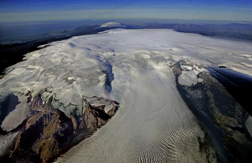
Katla is a relatively young volcano which like so many Icelandic volcanoes formed when Iceland was covered by ice. Hence it is a tuya, steep-sided with a broad, flat top. Like other large Icelandic volcanoes, it has a very large summit crater described as a caldera, but one that did not come about as a result of the collapse of the volcanic edifice into an emptied and very large magma chamber as happened at Mount Mazama a.k.a. Crater Lake in Oregon, at Krakatoa or at Long Valley.

Fig. 1. Herðubreið, a subglacially formed tuya with steep sides and a flat top. Post-glaciation, erosion has made the sides less steep and a small post-glacial cone makes the top appear less flat than it once was. The similarity to Katla, once you allow for the vast differences in size, is obvious. (extremeiceland.is)
One of the keys to understand what goes on at Katla is to have an idea of what lies beneath the up to 700 meters thick glacier that covers her crater/caldera. In schematic representations of Katla, a magma chamber at the very shallow depth of three to five kilometres is often displayed. From reading descriptions of other volcanoes that have suffered caldera collapse or looking up a general definition of ”caldera”, it is easy to assume that Katla too must have a magma chamber that spans the entire width of the “caldera” and which, “once-upon-a- time” collapsed to for the present-day caldera. Nothing could be further from the truth, but alas, there is no direct information available that accurately describes what Katla’s magmatic system, the true volcano, looks like. We have to fill this gap ourselves.
The first thing to do is to look at what she has done in the past. If we look up her “Eruptive History” on the Smithsonian Global Volcanism Program website, we find that Katla is listed as having had 27 eruptions during the period Iceland has been settled by humans, some eleven centuries and counting. Of these, only the larger eruptions seem to have been registered prior to the middle of the 20th Century. Thus the 27 eruptions are divided as follows: Two VEI 0 (1955 and 1999), three VEI 3, fourteen VEI 4 (including the AD 934 “Eldgjá fissure eruption”) and four VEI 5 with a further four not assigned a VEI number. Of the four unassigned eruptions, one is listed as “subglacial, lava flows” and three as “subglacial, explosive”. Please take note of the dearth of smaller eruptions, VEI 0 – 2, as this is important and something we’ll return to later.
From this information, it is clear that Katla cannot have a single, caldera-sized magma chamber because such a chamber would contain several tens to even hundreds of cubic kilometers of magma, which in turn would have led to far larger eruptions. None have occurred. Since VEI 5 is assigned to eruptions that eject between 1 and 9 cubic kilometres of Dense Rock Equivalent (DRE) explosively, and Katla’s VEI 5 eruptions are remarkably consistent at between 1.2 and 1.5 cubic kilometres, anything much larger than some 3 – 4 cu km is rather out of the question. A caveat – given the area covered by the crater/caldera, there could be more than one such chamber responsible for her eruptions, in which case it would be fair to ask the question if Katla really is a single volcano or if not a description of her being several volcanoes rolled into one would be more accurate.
If we look at her eruptive history prior to Iceland being settled, deduced by tephrochronology – ash layers deposited being identified by their physical properties, such as chemical composition and grain size, as belonging to Katla and from the size, distribution and time derived for each individual layer of tephra, an eruption responsible for it is inferred – we find that there have been a multitude of eruptions, but only a few of which have been assigned a VEI number. Interestingly in every such case a VEI 3 or 4 has been deduced. Anything much larger must have left such extensive deposits that such a huge eruption cannot have escaped detection, hence we can conclude that no explosive eruptions larger than a small VEI 5 have ever occurred at Katla.
There have been two exceptions to the rule that Katla’s eruptions normally are in the VEI 4 range volume-wise. Both originate on her NE flank, outside the crater/caldera. Around 5550 BC, Katla was the source of the 5 cubic kilometres “Hólmsá Fires eruption” lava flow. In 934 AD, the four times larger “Eldgjá eruption” spewed forth some 18 cu km of lava and five cu km of tephra, or ash. Even if the total volume erupted in 934 AD, about 22 cu km DRE, is on the order of 50 times greater (25 to 200 times), a lowly “VEI 4?” has been assigned.
As the underlying causes and processes that drive “regional fissure eruptions” are vastly different and as they happen very rarely, seemingly with a time interval measured in several millennia in the same-ish location, fissure or rift eruptions should be considered separately – even if the visual appearance of the Katla crater/caldera suggests that a fissure eruption has at some point in the distant past intersected it. They are mentioned here because an article such as this cannot fail to do so, nor can it fail to give a reason why they are not included in the discussion.
Earlier I mentioned the apparent absence of small eruptions from her eruptive record with only two “possible subglacial eruptions” in 1955 and 1999 listed, to which can now be added the equally suspected or “possible” July 2011 subglacial eruption. As I write this, it seems that there may have been yet another, very minor hlaup. That such eruptions were not noted in earlier days is not surprising as the very small hlaups they resulted in were local nuisances rather than regional catastrophes of a major Katla jökulhlaup and would not have been seen as important enough to be recorded, even had they been observed. But how frequent could this type of small eruption be?

Fig 2. Seljansfoss Waterfall during the 2010 Eyjafjallajökull eruption (Binaural Waves Blogspot). Notice evidence of several minor eruptions on the mountainside above the waterfall.
We know from the 2010 Eyjafjallajökull eruption that it was preceded by two fissure eruptions at Fimmvörduhals that intersected each other. If we look at the topography and geography of Eyjafjallajökull, we can see many areas of monogenetic cones. This indicates that eruptions of the Fimmvörduhals type greatly outnumber eruptions at the main vent. At Askja, a similarly sized volcano albeit glacier-free and with a slightly smaller summit crater/caldera, there have been six small eruptions since the great eruption of 1875 and many prior.
Of the 24 eruptions (not counting the AD 934 Eldgjá fissure eruption) listed before it was realised that there were smaller eruptions that would only show as minor jökulhlaups, 20 are listed as VEI 3 or higher and three of the four not assigned a VEI number are listed as (subglacial and) explosive. At least 17 of the 23 explosive eruptions have been assigned a VEI of 4 or 5. The eruptive record of Katla thus indicates that in order to break through the up to 700 meters thick Mýrdalsjökull glacier, an eruption would need to be at least as powerful as to merit a designation of VEI 3. Thus – the reason for the dearth of smaller eruptions observed is that they are not energetic enough to break through thick glaciers such as Vatnajökull or Mýrdalsjökull to be visually obvious and the minor hlaups resulting have been much too insignificant to have been considered as a result of an eruption that never was seen.
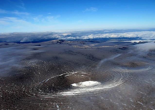
Fig. 3. Pits formed by melting from below in the Katla glacier, summer 2011. The glacier was still covered with tephra from the Eyjafjallajökull eruption which made such features stand out unusually well. (ModernSurvivalBlog, picture may originate with Icelandreview)
With the advent of aircraft, it was noted that there were pits in the glacier as if it had melted from below and the collapsed to form an ice crater. These pits are relatively numerous and vary in size. They have been explained as due to either strong hydrothermal activity or, in the case of the larger ones, as the result minor subglacial eruptions.
The obvious conclusion is that in the case of Katla, small eruptions of the Fimmvörduhals type far outnumber the bigger, recorded eruptions. This is vital for understanding how a volcano such as Katla is built and works.
Let us for a moment return to what I like to call “Katla’s defrosted twin”, Askja. Here we can see, side by side, the effects of the two types of eruption. In 1875 she had the big VEI 5 eruption, about four times as great as Katla’s historic VEI 5s, that would eventually form lake Öskjuvátn. Here we have a magma chamber where magma collected over time, partially re-melting and absorbing the chamber walls which together with fractionating led to the body of magma collected being far more silicic than the basalt injected into the chamber, which provided the heat or energy for the process. This went on for centuries, quite likely millennia as GVP lists the preceding very large eruption at Askja as having occurred about 11,000 years ago, until a final basaltic intrusion was energetic enough to unbalance the magma chamber and the big eruption of 1875 followed. Please note that both before and after, there have been many smaller, basaltic eruptions that have evidently bypassed the main magma chamber on their way to the surface, one of which caused the miniscule crater Vítí located immediately north of Lake Öskjuvátn
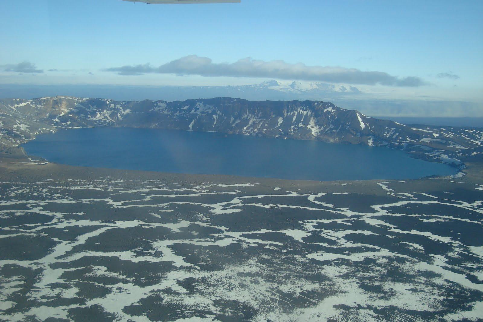
Fig. 4. “Katla’s defrosted twin”, Askja. Aerial photograph inside and above the Askja caldera with Lake Öskjuvatn and the miniscule crater Viti barely discernible on the near left-hand side of the lake. (uwmyvatn blogspot)
This too is what I believe must have been happening and is going on at Katla. Sturkell and his co-authors in their 2009 paper “Katla And Eyjafjallajökull Volcanoes” note that the products of Katla’s eruptions are bimodal, comprising alkali basalt and mildly alkalic rhyolites “with intermediates very subordinate”. One, or possibly more magma chambers where magma collects, fractionates and grows more silicic, a process that takes hundreds if not thousands of years which is why more than one magma chamber seems to be required in order to account for the relatively frequent eruptions of Katla, until there eventually is an eruption of “mildly alcalic rhyolites”, accompanied by tens to hundreds of smaller, alkali-basaltic eruptions which due to their location under the ice in a watery environment, gouge out small craters and fill in the bigger ones with mostly small, broken fragments of lava, piles of pillow lava or even small lava flows or easily eroded cones. When a big eruption occurs, the glacier first closes the wound, then the crater gets back-filled with loose rubble which gets pasted over with more solid lava flows from later eruptions.
This process has been going on for as long as Katla has existed. Not only has this constant remodelling inside the crater/caldera left a kilometres-deep zone of clastic, i.e. broken or fragmented, rock mixed with water, it also in my opinion explains how the caldera was formed in the first place. This layer extends down to not much above the roof/-s of the magma chamber/-s. As freshly injected basalt from the mantle makes its way up, it will eventually encounter this water-rich zone and result in intense activity, hydrothermal at first, and if the intrusion continues, hydromagmatic. It is primarily this activity we see when we look at the tremor charts of the SIL-stations surrounding Katla, in particular the one located at Austmannsbunga, on the north-eastern crater/caldera wall.
In the next instalment, it is time to take a look at Katla’s neighbours Eyajafjallajökull and the Gódabunga “cryptodome” and try and separate their activity from that of Katla so that we can finally figure out what she may have been up to over the last few years and how likely an eruption in the near future could be.
Part II
It is now time to have a look at what’s going on and try to paint a coherent picture of what she actually is, is up to and able to do, but first let us recapitulate what we found previously:
- There is a general interest in Katla because she is and has been regarded as a very dangerous volcano by generations of Icelanders.
- The presentation of Katla in media is skewered by vested interests ranging from scientists who hope to increase their professional and/or public standing, people trying to cash in on the interest generated such as journalists and bloggers, and finally, there are people trying to increase their standing within the subculture of doomsaying and alarmism.
- Katla is a massive but relatively young volcano, located on the MAR, and formed when Iceland was covered by glaciers.
- The records include two large fissure eruptions on the NE flank of Katla; the prehistoric 5 km3 Hólmsá Fires of 5550 BC and ~22 km3 Eldgjá eruption in 934 AD. In historic times, the 1100 years or so that Iceland has been settled, there have been 27 listed eruptions (28 if the inferred minor subglacial 2011 eruption is included), 23 of which have been explosive.
- Of the 23 explosive eruptions, three have been assigned VEI 3, thirteen VEI 4 and four VEI 5.
- The four VEI 5 eruptions are remarkably alike in size at 1.2 – 1.5 km3, which is at the upper end of what Katla probably is able to do but at the very lower end of VEI 5 eruptions.
- Tephrochronology (in some cases complemented by radiocarbon dating) has identified a further 103 eruptions going back ~8,500 years, and in the few cases where a VEI has been assigned, none have been greater than a VEI 4.
- Katla does not possess a caldera-sized magma chamber.
- In order to account for the great number of explosive eruptions which involve more evolved magmas, Katla could have more than a single magma chamber.
- The available evidence suggests that in order to break through the up to 700 meters thick Mýrdalsjökull glacier, an eruption must be at least a substantial VEI 3.
- Direct and (primarily) indirect evidence suggests that smaller eruptions, mainly basaltic VEI 0 – 2 eruptions are severely underrepresented in her eruptive record and ought to exceed the number of observed eruptions.

Fig 5. Mýrdalsjökull showing the main glacier outlets, directions of jökulhlaups and areas affected. E – Entajökull, S – Sólheimajökull, K – Kötlujökull, M – Markarfljot, Ss – Sólheimasandur, MS – Mýrdalssandur. Eyjafjallajökull is to the left and the smaller glacier above is Tindfjallajökull (adapted from Google Maps).
The greatest danger from Katla comes from the very quick and extensive melting of the glacier caused by large eruptions which results in destructive jökulhlaups. There are three major outlets from the glacier: Entujökull to the NW that empties into the Markarfljot river and valley north of Eyjafjallajökull, Sólheimajökull to the SSW that empties onto the Sólheimasandur and finally, Kötlujökull to the SE that empties in a great arc east through south onto the Mýrdalssandur. What ought to be prime farmland and in fact once was settled, is nowadays an unsettled wasteland because of the devastating jökulhlaups unleashed by Katla. This is the true reason why Katla is considered to be such a dangerous volcano.
The fact that one often comes across the reference that in the days before the Hringvegur (ring road), “people were afraid to traverse the Sólheima- and Mýrdalssandur because of the frequent jökulhlaups” is another indication that smaller and unrecorded eruptions that cause only minor hlaups are far more frequent than the 40 – 80 years often given as the interval between main, and thus visible, eruptions.

Fig. 6. The foundations of the old bridge across the Múlakvísl river destroyed by the July 9th 2011 jökulhlaup are visible to the left. The new bridge was laid down a week later. (photo John A Stevenson, GVP website)
Apart from the postulated connection between the Eyjafjallajökull and Katla volcanoes, one question that always crops up is the Goðabunga cryptodome. Many volcanologists maintain that it is a part of the volcanic system of the Katla central volcano. Others, notably Sturkell and his co-workers, claim it is part of the Eyjafjallajökull volcanic system. In order to shed some light on this issue, I asked our own GeoLurking if he could make a plot of all the earthquakes from 1994 up to and including the 2010 Eyjafjallajökull eruption. The results are quite clear and do throw up a surprise:

Fig 7. E-W cross section, view from south, through Eyjafjallajökull, Goðabunga and Katla. Plot by and courtesy of GeoLurking. The “lines” formed at approximately 5, 3 and 1.1 km at Goðabunga and Katla are most likely artefacts caused by quakes being assigned a poorly defined depth. The latter, 1.1 km, is the default depth assigned by the automatic system in case it cannot compute a depth within the predetermined level of certainty and unless they are manually checked, which is not the case of every quake, automatic depth remains uncorrected, hence these artefacts.
From this cross section, it is quite clear that there is no connection between the Eyjafjallajökull volcanic system and Katla. Eyjafjallajökull has its own, well-defined feeder system from the Moho (first molten layer beneath the Earth’s solid crust) as does Katla, thus they are wholly independent of one another. As can also be seen, albeit not as clearly, Goðabunga too seems to be independent of either Eyjafjallajökull and Katla, the ramifications of which will be the subject of a later post by Carl. Sufficient to say that when we contemplate what Katla herself may be up to, we must differentiate between activity at Goðabunga and activity at Katla. Once we do, we see that while Goðabunga is more or less continuously active, Katla operates in bursts and seems to be most active during summer and autumn when the ice cap is at its, relatively speaking of an up to 700 m thick glacier, thinnest.

Fig 8. Activity post-Eyjafjallajökull. Activity at Eyjafjallajökull is minor and has to do with the system settling down after the end of the eruptive phase. Note that at a depth of 0 to 5 km or so, there seem to be three separate areas of activity at Katla. (Plot by and courtesy of GeoLurking.)
After the Eyjafjallajökull eruption, Katla seems to have entered an active phase with a suspected subglacial eruption on July 9th 2011 and several pits or craters forming on top of the glacier. This activity seems to be localised to three main areas within the caldera:

Fig. 9. Earthquake activity at Katla July 9th 2011, the day of the jökulhlaup and suspected subglacial eruption. Both the 1823 and 1918 eruptions occurred close to but just east of this area. The 1823 eruption occurred close to the easternmost red spot while the 1918 eruption was roughly at the rightmost dark blue spot below it. (IMO)

Fig 10. Earthquake activity at Katla July 17th 2011. (IMO)

Fig. 11. Earthquake activity at Katla July 21st 2011. The 1755 eruption was situated in the same area as the three overlapping orange spots.
As can be seen, there are at least three distinct areas of activity inside the caldera with the one associated with the inferred July 9th eruption well to the south. The pits formed in the glacier also align with these three areas, albeit the pits to the northeast seem more drawn out along the caldera wall and not over the center of activity. These three areas seem to tie in with the three areas of activity noted in fig 4 as do the locations of three of Katla’s major eruptions. Thus there is not a single vent, but at least three at surface distances of approximately 5 to 8 km from each other. It is equally likely to judge from Fig 7. and Fig 8. in conjunction, that at great depth, they do have a common source.
I will now present you with my personal view of Katla, but do not be afraid to disagree or draw your own conclusions (within reason please, no Katlatubos here):
Katla is a young volcano and far more active than has previously been thought. Unlike the similarly aged but much less active Eyjafjallajökull, Katla has had more time to develop her system of sills to the point where they are fewer in number than they originally were but have a substantially larger magma-carrying capacity and approach or may have reached the point where they can be considered magma chambers proper. Since cooking evolved magmas takes a long time, usually millennia in the case of cubic kilometre-sized silica-rich magmas and at the very least many centuries for intermediate magmas, it is highly likely that Katla possesses several pockets of magma capable of eruptions ranging from high VEI 3s to small VEI 5s. Not only do the times between such eruptions argue this, their wide spread of location within the caldera does so too.
The most common type of eruption at Katla is the small, subglacial eruption of a few tens of millions of cubic meters of basaltic magmas. These eruptions are not energetic enough to break through the very thick Mýrdalsjökull glacier and the only proofs of their existence are intense earthquake swarms followed by minor jökulhlaups and later observations of deep pits or craters, sometimes water-filled, in the glacier ice. My guesstimate is that there may be many such small eruptions over any given ten-year period, and possibly in the case of a period of high activity, there may even be more than one in a single year. By back-tracking and investigating old accounts over the past few centuries of jökulhlaups in the area not associated with visible eruptions, it ought to be possible to identify many of these minor eruptions.
While a larger “proper” eruption of Katla in the VEI 3 – 5 range cannot be ruled out, I find one unlikely at present as the current activity mostly is in areas already depleted of evolved magmas by geologically speaking very recent major eruptions. Also there is little sign of the uplift required on GPS. If one were to occur, the odds for one towards the upper end of what Katla is able of ought to be better in the Eastern to Northern parts of the caldera.
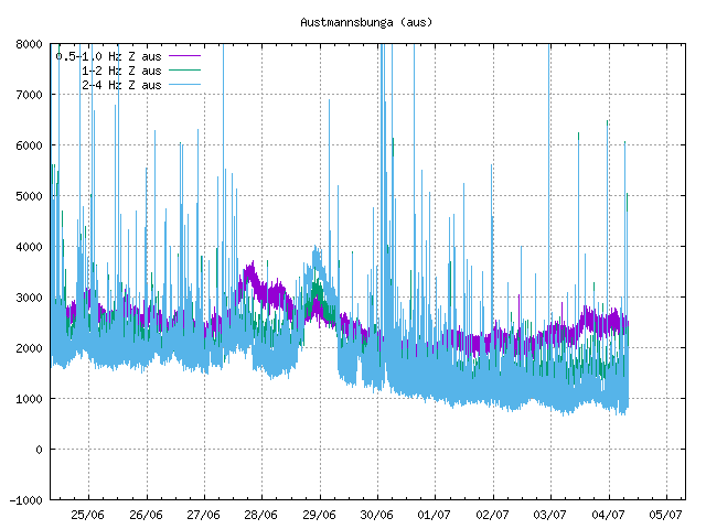
Finally, what we do see when we look at SIL-stations such as Austmannsbunga, located on the NE caldera rim (not a coincidence, see above), is hydrothermal activity following a period of possibly still ongoing magmatic intrusion and not signs of an imminent, large eruption.
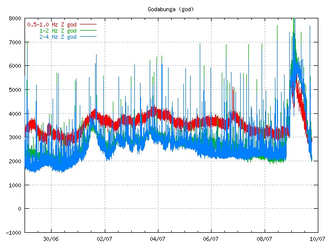
Fig 12. Hydrothermal activity at Katla as shown on the Austmannsbunga SIL (IMO) (Source: https://icelandgeology.net/?p=3291)
I’m sorry to be such a boring old fart, but if this is unsatisfactory, start looking for intense earthquake activity at some 25 – 10 km depth, showing on the IMO map for Mýrdalsjökull as being in the Eastern to Northern part of the caldera, activity that shows a clear upwards trend and spreads when it reaches depths approaching 5 km!
HENRIK, May/June 2012
Addendum
Henrik wrote this in 2012, after the burst of activity at Katla in the summer of 2011. It is now 2023 and we again had an earthquake swarm at Katla. And again it happened in summer. The activity occurred on 30 June, and was all shallow but far larger than might be expected of normal summer activity caused by ice melt. The strongest earthquake was M4.4 and around 10 quakes were M3. Not huge, but significant.
The swarm continued events from 4 May when there was an earlier swarm in the same general area. That swarm was a bit stronger with three quakes of M4. It briefly caused the status of Katla to be set to ‘yellow’ before returning to ‘green’ which it still is. That sequence was rather uncommon for early spring, normally a quiet time for Katla! Katla comes to life in summer. The last time a similar (albeit weaker) swarm occurred in Katla was in September 2016.
Was there any sign of an eruption? If we look at the tremor plot, a bump in blue line is evident on June 29. It is weak but otherwise similar to what was seen in 2011. The peak frequency of 2-4 Hz can be associated with glacial floods, i.e. increased ice melt. A magmatic eruption (bubbly magma moving up in the conduit) would normally show up equally at all three frequency ranges. However, this particular bump occurred a day before the earthquake swarm so is not directly caused by the shaking.
June 2023, Katla
It is worthwhile looking underneath the ice. Katla has a distinct caldera with a deep central depression, a steep rim which has three gaps where water can flow out, and several flow channels feeding the surrounding rivers. The ice cover reaches 700 meters thickness near the northeastern rim. About half the icecap lies above the caldera; a similar area of ice covers the northeastern slopes. The caldera shows geothermal activity. This is nicely shown by the icecap which contains several cauldrons where the heat has melted some of the ice. The hydrothermal activity is mainly located just inside the caldera rim, along the western and eastern edge. This suggests that the heated water is circulating via the ring fault. There are also two active areas within the caldera.
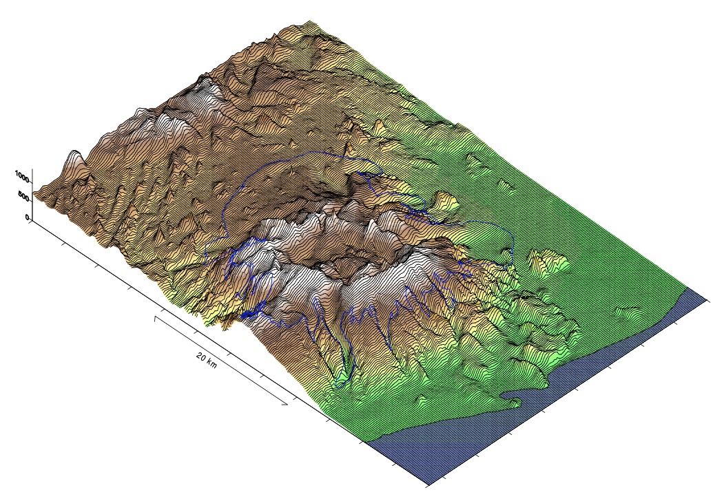
The ice-free caldera map. This view is from the southwest. Image from Helgi Björnsson et al, 2000, Jokull 49, 29 (https://www.researchgate.net/publication/285499559_Surface_and_bedrock_topography_of_the_Myrdalsjokull_ice_cap_Iceland_The_Katla_caldera_eruption_sites_and_routes_of_jokulhlaups).
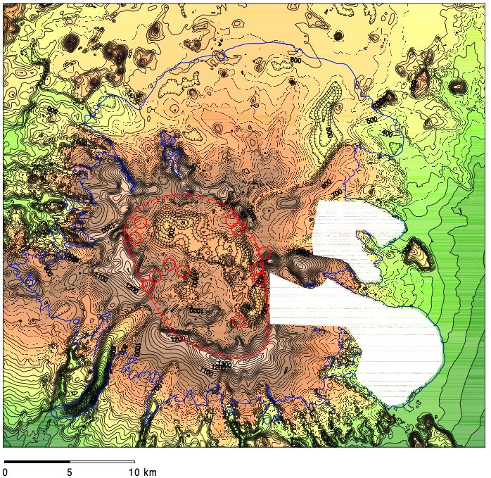
High resolution map of the caldera. The circles indicate hydrothermal activity. North is up. Image source Björnsson et al.
The recent earthquake swarm was located just inside the northeast rim of the caldera (see Jon’s post: https://icelandgeology.net/?p=11319). The swarm in May was in the same area. The caldera map shows a narrow gorge just outside the caldera, which curves a bit but generally runs north-northeast. This is the rift that fed the Eldgja eruption. The swarm was located a little south of there, within the caldera. Rest assured: last week’s activity had no relation to Eldgja!
Previous activity after the large 1918 eruption occurred on 25 June 1955, 17 July 1990 and 8 July 2011, all in the caldera. All three were hydrothermal events where magma was either not involved at all or was only a minor byproduct. Notably, all were in the summer, which clearly indicates that they were driven by summer melt: Katla is a summer volcano. We might even call it an august volcano, fitting both its size and seasonality. (The eruption of 1918 though was on 12 Oct, showing its magma is not limited by the season.) In 1955, two ice cauldrons formed on the southeast rim and a small jokulhaup occurred. In 1999, the activity was on the southwest rim with tremor and a jokulhaup. The 2011 activity was larger, with strong tremor, earthquakes in the south and east of the caldera up to M3.4, and a jokulhaup which swept away a bridge. The effect was likely amplified by the fact that water had accumulated in the caldera over the preceding year, causing uplift of the icecap.
The 2023 activity fits with these events. The location is a bit north of the 1955 event. The earthquake activity was stronger but it has not caused a jokulhaup – perhaps because the location is a bit away from the immediate drainage channels.
Was it an eruption? Or perhaps a precursor? Katla is a mysterious beast. It has much to hide – it keeps its icecap for a reason.
There is in fact no evidence that the earthquake swarm was related to an eruption. There may have been a small hydrothermal event, as evidenced by the sulphur smell around the rivers. This may have preceded the swarm. However, the size of the earthquakes and the fact they followed on from a similar swarm from two months before does suggest a pressure change around the ring fault. That could be coming from a dike or from increased water circulation. The time of the first swarm may make the first possibility more likely, at least for that event. Perhaps it was the continuation of the intrusions from the deep which happened a decade ago. If you want to know, see the second link below.

My guess for now (and it is only a guess) would be that the earthquake activity is related to (but not coincident with) a small hydrothermal event. — which may not have happened yet! This may be or may become one of Henrik’s missing VEI 0’s. Whether it will become anything more is just a matter of wait and see. Katla is still a quantum volcano – it remains impossible to predict.
Post by Henrik, May 2012; addendum by Albert, July 2023


Is there confirmation that there is just the one fissure system just north of Litli-Hrutur?
It is just very coincidental how the weather closed in out of the blue on the Fagradalsfjall and Langihryggur cams around 10 mins before the first signs of the confirmed eruption (which based on the cloud movement is not downwind). I’m wondering if there is also a second site of activity just to the east of the Langihryggur web cam that is seeding the low cloud/fog? The original Fagradalsfjall eruption was initially centered on an old cone but then a few days later further fissures opened and if a recall correctly it was at two separate points. Likewise when the graben formed after the initial eruption at Holuhraun, we then had two separate new fissures open up for a while before one became dominant.
https://twitter.com/WxNB_/status/1678460470494130176
Drone footage of the ongoing eruption in Iceland.
WOW!!!
That really is a WOW drone video! I have never been over keen on drones because of idiots flying them over peoples gardens in UK, Now I see they are wonderful when used for the correct purpose. Thanks so much for posting that Luis.
I cannot believe I called this location correctly on the 9th July. Proof?
Repost from 9th July.
Alice
09/07/2023 at 21:32
Oh and I guess at the eruption coming up at the north side of Litli Hrutur very close to the base.
I did also say I was probably going to be wrong though, )
Well done! And I managed the first red lava shot (via drone control)! *happy dance*
Absolutely brilliant Stars. I was so happy to get confirmation of the eruption so close to the base of Litli Hrutur. Where would we be without drones,
Another screenshot from livestream
And sharpened, contrast enhanced zoomed in shot
https://imgur.com/a/EGKSUMm
My take for the first fissure based on the Squonk first facebook photo. Note the distinctive moss outlines and green dips corresponding, and the bare path that takes a right-angle bend over the moss bank.
I reckon you have that line just right Stars, I saw a shallow quake whose coordinates were exactly on the black blob close to the base and close to where your line was drawn and seing the apparent shallowness I took an semi-educated guess, So more luck than judgement from an old lady.
So more luck than judgement from an old lady.
Sometimes luck is just good judgement made at an opportune time.
😉 I admit to being astounded when I saw the first smoke coming round the mountain, 🙂
Well done. The media should followed your conversations. They would have placed a camera on the hill they all flocked to after the ground opened up. The plots were there and the lines drawn. I don’t see that location as being as accessible as the priors.
Does anyone have a link to a webcam that is pointing in the right direction?
this is the best you can geet right now
https://www.visir.is/g/20232438290d/visir-i-beinni-i-thyrlu-flugi-yfir-gos-stodvum
It appears that would be the best location for a permanent camera station. Who ever is handling the video now is quite unsteady.
Looking at that link it is amazing how quickly the lines of fire unzipped!
Anything is welcome at this point, but the news guy blocking the view and yabbering so we can’t even hear it proper.
This is ‘news as it is happening’ for these guys. They have no interest in the science. That will come.
I tried that link and got Icelandic football. The Vikr team was winning….
Soo fun its going, it looks alot like the meradalir 2022 lava fluid much more so than Etna, but not as liquid as 2021 ”silver phase of fagradalshraun”
Sooo happy that we have this Volcano Cafe to get so many links to the eruption so quickly,
Looking after my elderly mother I missed all this. And who put that mountain slope in the way of the Bent Stream camera!
It always happens that way! And being over seventy myself I thank you for being a caring person. Family always come first. So well done you.
That’s kind. Mother is 97! And very independent, too.
Remember that time when you stayed awake (couldn’t sleep if you wanted to) for about 30 hours waiting on an imminent volcano and then when it finally broke through you couldn’t keep your eyes open? Oh wait, that’s not you, it’s me. I did that. Very recently even.
I imagine right now a frantic race between RUV, MBL and Visir to find a better spot to relocate their webcams.
I hope so 😀
https://www.instagram.com/reel/CuhoUh_oomI/?utm_source=ig_embed&ig_rid=23e81311-1ce4-4a5f-9069-de8c1ca2cb13
Not sure if this has been posted here yet, link borrowed from Siggi Ragnur on DrFox2000’s current live stream.
Thats nice, thanks, but not live for me.
A small glimpse…
oops!
didn’t work..
It’s on mbl.is youtube channel.
Way better than just smoke!
Works for me Llavalamp. Thanks indeed
The mist is clearing and it is starting to be visible on some of the original cams now.
Eg: https://youtu.be/uZGleOgreBY
Live drone streaming will start in 40 minutes:
https://www.youtube.com/live/o2WTGmiLbmk
In the meantime it’s showing old footage from previous eruptions.
21.00 hrs British Summer Time. Thanks muchly for the link.
Can’t get a good quality from Youtube. It keeps pausing and jumping, even though I’ve previously had no problem streaming 720p from YT on my home connection. Even at 480p it won’t work well.
Any suggestions?
He had technical problems and it seems like he ended the stream. It wasn’t problems on your side.
I have the same problem. It appears now to have stopped recording altogether. Hopefully he is able to post a proper video later cos this live isn’t working.
Back on and working partially
He’s restarted the stream.
According to the most recent estimate provided by scientists, low lava fountains are erupting from a nearly continuous 900m long fissure. #Fagradalsfjall #Keilir
https://twitter.com/WxNB_/status/1678477040473763847
The location of the eruption is where scientists had predicted at the eastern slopes of Litli Hrutur. The lava is flowing towards the South from a 900m long fissure. According to scientists based on the initial size of this eruption, that is bigger than the previous two.
https://twitter.com/gislio/status/1678475067049517073
My own personal observations of events leading up to the fissure eruption.
1. The website https://vafri.is/quake/#close posting quakes proved invaluable this time for knowing how events were progressing. I watched the screen literally hours and began to discern patterns. Once there was like a surge and small quakes burst out over in the Krisuvik area and you could follow this surge by watching for about 1/2 hour or so. I took this to mean a magma surge. The constant activity to the NE showed that pressure was high.
2. A key comment made by Tomas Andersson about triggered quakes related to the inSar butterfly picture helped me to understand the quakes occurring on the vafri.is/quake website for the past 3 days.
3. The FAF seisometer was a good source of watching the microquakes, and I am sure that at least 3 episodes (barefuly distinguishable) of microtremors occurred. The time from 14:50 pm to 18:00 pm today (2023-July-10) on the seismo shows a slightly thicker trace. This seems to indicate that actually watching microtremors is a very difficult science even today and fissure eruptions are still hard to accurately predict
4. The strong 5.22 quake yesterday had few aftershocks, indicating (my terms) mushy ground or softened up ground by magmatic intrusion. This in hindsight was an indicator of closeness to the actual eruption.
5. There appears to have been a small microquake around 16:38 pm which slightly shook the RUV cameras on Litli-Hrutar, and I take this as the final breakthrough of the fissure. IMO dated the eruption at 16:40 and the RUV north camera showed the first smoke at 16:41:07 pm. It is really hard to catch fissure eruptions as they first begin.
6. The two flights of small birds that I saw around midnight Iceland time were interesting. Birds seem to have a foreknowledge of events, and their flight path was directly away from the region at about right angles to it (giving them the maximum distance via minimal flight time) Before the Hebgen Montana 7.3 quake of Monday August 17, 1959, the water fowl left Hebgen Lake about 2 pm in the afternoon and their absence was noted in the sheriff’s log at West Yellowstone. The quake that evening gave the reason why the waterfowl left. They came back to the lake after the 3rd aftershock on Wednesday Aug 19th or so. My dad took our family to this epicenter about 2 or 3 days later and we saw the lake filling up, and all the damage and trees disappearing into the water and it left an indelible impression upon me as an 8 year old.
7. Scientifically things have improved, we’re in a better knowledable condition that when the 1st eruption started back in 2021.
8. The hot water pouring from the borehole in Avedir (spelling) was definitely a sign of nearness of the eruption, but it was 11 km from Keilir. That is a wide area for a thermal pulse to travel. Do we know much about how much thermal energy is spread when a dike intrudes? More studies of borehole water and temps needs to be done.
9. Several people on Volcano Cafe gave fairly accurate predictions of the location of the fissure eruption, I believe Albert might have been the first to speak up. Chad gave one as did Alice, but there were others and I apologize for not mentioning you.
Finally the excitement leading up to a fissure eruption is almost addictive. It really is fun watching a volcanic event like this occur, especially when it is fissure eruptions which have not occurred for some 800 years.
These are some thoughts as I reflect back through events leading up to the fissure eruption today.
Seems like a second, E-W trending fissure has opened up a few hundred metres in front of RUV Cam A.
Yes, looks like it, but partly obscured by the smoke.
From Islam Finbogason’s drone stream on YT. He’s having some technical difficulties with the connection but already this shot is pretty epic:
https://i.imgur.com/mVMY9KM.jpeg
Isak Finbogason*
Posting from my phone. Didn’t catch the autocorrect.
Amazed what a volume already erupted!
From the stuttering live drone, people circled to give a sense of scale t
That’s a quite sizable fissure, it will most probably form impressive cones once it starts to focus on one or two vents.
Looking at Isak’s wide shot, the lava looks to be flowing into a valley with a temporary pond, just west of a low north-trending ridge. The cloud shadow on Google maps means I can’t see where this leads. Perhaps the flow will be backing up around the little ridge and carrying on south?
Has the location of the eruption shifted, or expanded, during the past hour? There is lava visible in the live video feeds from Litli-Hrutur which didn’t seem to be there earlier.
There’s been some chatter in the livestreams and Facebook that a second fissure has opened up, but I couldn’t get any official confirmation of that.
Another fissure open…
Yep, it is visible on the Litli Hrutur – Nordur cam. It is further north.
Isak’s stream is truly epic right now. Very appreciative for what he’s doing.
It looks like there’s a bathtub circulation at the north foot of Litli Hrutur, but the main stream is flowing past and heading for that valley.
Those people who arrived by the cycle track better watch their backs…
Live drone streaming fluid last minutes.
The eruption was around seven o’clock, approx. 10x more powerful than previous eruptions in the Reykjaneselds of our time. However, between 7 and 8 new cracks opened on the way to Keili. We urgently need new photos/webcam that show the location of this crack and are not behind smoke
https://twitter.com/danielfj91/status/1678503182870237184
NOTE: All access routes to the eruption closed and the area evacuated.
Twice the amount of lava than in the last eruption and significantly more gas.
Well, there’s at least 50 people wandering about on the moss plain and on the low north-trending ridge…
Eruption was first visible at ~4.40pm local Iceland time
New post is up. Eruption!
https://www.volcanocafe.org/fagradalsfjall-season-3/