After our ‘quantum Katla’ post, it is now time to return to the real Katla. For in the real world, Katla has been showing unusually strong shaking. It turned out that Henrik had already done much of the work for us. Here is a resurrected post from the dungeons of 2012 where young Henrik keeps our Katla feet firmly on the ground. It includes an addendum on the current activity.
Rest in peace, Henrik, and when Katla blows we will raise a glass to you. (Clive, 2019)
Part I
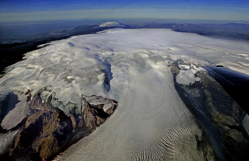
Katla is a relatively young volcano which like so many Icelandic volcanoes formed when Iceland was covered by ice. Hence it is a tuya, steep-sided with a broad, flat top. Like other large Icelandic volcanoes, it has a very large summit crater described as a caldera, but one that did not come about as a result of the collapse of the volcanic edifice into an emptied and very large magma chamber as happened at Mount Mazama a.k.a. Crater Lake in Oregon, at Krakatoa or at Long Valley.

Fig. 1. Herðubreið, a subglacially formed tuya with steep sides and a flat top. Post-glaciation, erosion has made the sides less steep and a small post-glacial cone makes the top appear less flat than it once was. The similarity to Katla, once you allow for the vast differences in size, is obvious. (extremeiceland.is)
One of the keys to understand what goes on at Katla is to have an idea of what lies beneath the up to 700 meters thick glacier that covers her crater/caldera. In schematic representations of Katla, a magma chamber at the very shallow depth of three to five kilometres is often displayed. From reading descriptions of other volcanoes that have suffered caldera collapse or looking up a general definition of ”caldera”, it is easy to assume that Katla too must have a magma chamber that spans the entire width of the “caldera” and which, “once-upon-a- time” collapsed to for the present-day caldera. Nothing could be further from the truth, but alas, there is no direct information available that accurately describes what Katla’s magmatic system, the true volcano, looks like. We have to fill this gap ourselves.
The first thing to do is to look at what she has done in the past. If we look up her “Eruptive History” on the Smithsonian Global Volcanism Program website, we find that Katla is listed as having had 27 eruptions during the period Iceland has been settled by humans, some eleven centuries and counting. Of these, only the larger eruptions seem to have been registered prior to the middle of the 20th Century. Thus the 27 eruptions are divided as follows: Two VEI 0 (1955 and 1999), three VEI 3, fourteen VEI 4 (including the AD 934 “Eldgjá fissure eruption”) and four VEI 5 with a further four not assigned a VEI number. Of the four unassigned eruptions, one is listed as “subglacial, lava flows” and three as “subglacial, explosive”. Please take note of the dearth of smaller eruptions, VEI 0 – 2, as this is important and something we’ll return to later.
From this information, it is clear that Katla cannot have a single, caldera-sized magma chamber because such a chamber would contain several tens to even hundreds of cubic kilometers of magma, which in turn would have led to far larger eruptions. None have occurred. Since VEI 5 is assigned to eruptions that eject between 1 and 9 cubic kilometres of Dense Rock Equivalent (DRE) explosively, and Katla’s VEI 5 eruptions are remarkably consistent at between 1.2 and 1.5 cubic kilometres, anything much larger than some 3 – 4 cu km is rather out of the question. A caveat – given the area covered by the crater/caldera, there could be more than one such chamber responsible for her eruptions, in which case it would be fair to ask the question if Katla really is a single volcano or if not a description of her being several volcanoes rolled into one would be more accurate.
If we look at her eruptive history prior to Iceland being settled, deduced by tephrochronology – ash layers deposited being identified by their physical properties, such as chemical composition and grain size, as belonging to Katla and from the size, distribution and time derived for each individual layer of tephra, an eruption responsible for it is inferred – we find that there have been a multitude of eruptions, but only a few of which have been assigned a VEI number. Interestingly in every such case a VEI 3 or 4 has been deduced. Anything much larger must have left such extensive deposits that such a huge eruption cannot have escaped detection, hence we can conclude that no explosive eruptions larger than a small VEI 5 have ever occurred at Katla.
There have been two exceptions to the rule that Katla’s eruptions normally are in the VEI 4 range volume-wise. Both originate on her NE flank, outside the crater/caldera. Around 5550 BC, Katla was the source of the 5 cubic kilometres “Hólmsá Fires eruption” lava flow. In 934 AD, the four times larger “Eldgjá eruption” spewed forth some 18 cu km of lava and five cu km of tephra, or ash. Even if the total volume erupted in 934 AD, about 22 cu km DRE, is on the order of 50 times greater (25 to 200 times), a lowly “VEI 4?” has been assigned.
As the underlying causes and processes that drive “regional fissure eruptions” are vastly different and as they happen very rarely, seemingly with a time interval measured in several millennia in the same-ish location, fissure or rift eruptions should be considered separately – even if the visual appearance of the Katla crater/caldera suggests that a fissure eruption has at some point in the distant past intersected it. They are mentioned here because an article such as this cannot fail to do so, nor can it fail to give a reason why they are not included in the discussion.
Earlier I mentioned the apparent absence of small eruptions from her eruptive record with only two “possible subglacial eruptions” in 1955 and 1999 listed, to which can now be added the equally suspected or “possible” July 2011 subglacial eruption. As I write this, it seems that there may have been yet another, very minor hlaup. That such eruptions were not noted in earlier days is not surprising as the very small hlaups they resulted in were local nuisances rather than regional catastrophes of a major Katla jökulhlaup and would not have been seen as important enough to be recorded, even had they been observed. But how frequent could this type of small eruption be?

Fig 2. Seljansfoss Waterfall during the 2010 Eyjafjallajökull eruption (Binaural Waves Blogspot). Notice evidence of several minor eruptions on the mountainside above the waterfall.
We know from the 2010 Eyjafjallajökull eruption that it was preceded by two fissure eruptions at Fimmvörduhals that intersected each other. If we look at the topography and geography of Eyjafjallajökull, we can see many areas of monogenetic cones. This indicates that eruptions of the Fimmvörduhals type greatly outnumber eruptions at the main vent. At Askja, a similarly sized volcano albeit glacier-free and with a slightly smaller summit crater/caldera, there have been six small eruptions since the great eruption of 1875 and many prior.
Of the 24 eruptions (not counting the AD 934 Eldgjá fissure eruption) listed before it was realised that there were smaller eruptions that would only show as minor jökulhlaups, 20 are listed as VEI 3 or higher and three of the four not assigned a VEI number are listed as (subglacial and) explosive. At least 17 of the 23 explosive eruptions have been assigned a VEI of 4 or 5. The eruptive record of Katla thus indicates that in order to break through the up to 700 meters thick Mýrdalsjökull glacier, an eruption would need to be at least as powerful as to merit a designation of VEI 3. Thus – the reason for the dearth of smaller eruptions observed is that they are not energetic enough to break through thick glaciers such as Vatnajökull or Mýrdalsjökull to be visually obvious and the minor hlaups resulting have been much too insignificant to have been considered as a result of an eruption that never was seen.
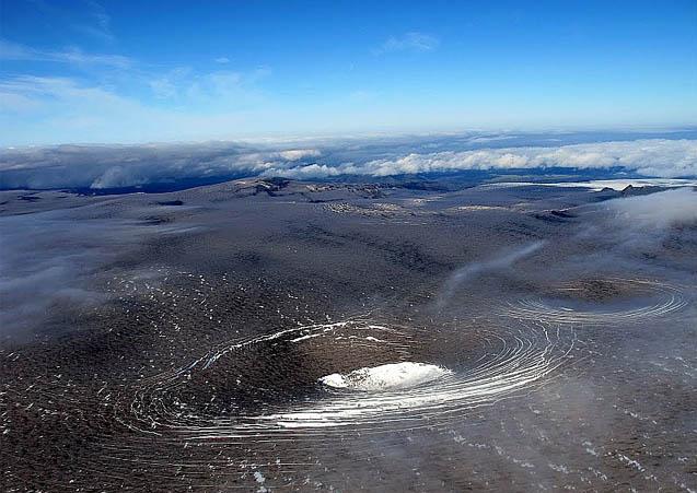
Fig. 3. Pits formed by melting from below in the Katla glacier, summer 2011. The glacier was still covered with tephra from the Eyjafjallajökull eruption which made such features stand out unusually well. (ModernSurvivalBlog, picture may originate with Icelandreview)
With the advent of aircraft, it was noted that there were pits in the glacier as if it had melted from below and the collapsed to form an ice crater. These pits are relatively numerous and vary in size. They have been explained as due to either strong hydrothermal activity or, in the case of the larger ones, as the result minor subglacial eruptions.
The obvious conclusion is that in the case of Katla, small eruptions of the Fimmvörduhals type far outnumber the bigger, recorded eruptions. This is vital for understanding how a volcano such as Katla is built and works.
Let us for a moment return to what I like to call “Katla’s defrosted twin”, Askja. Here we can see, side by side, the effects of the two types of eruption. In 1875 she had the big VEI 5 eruption, about four times as great as Katla’s historic VEI 5s, that would eventually form lake Öskjuvátn. Here we have a magma chamber where magma collected over time, partially re-melting and absorbing the chamber walls which together with fractionating led to the body of magma collected being far more silicic than the basalt injected into the chamber, which provided the heat or energy for the process. This went on for centuries, quite likely millennia as GVP lists the preceding very large eruption at Askja as having occurred about 11,000 years ago, until a final basaltic intrusion was energetic enough to unbalance the magma chamber and the big eruption of 1875 followed. Please note that both before and after, there have been many smaller, basaltic eruptions that have evidently bypassed the main magma chamber on their way to the surface, one of which caused the miniscule crater Vítí located immediately north of Lake Öskjuvátn
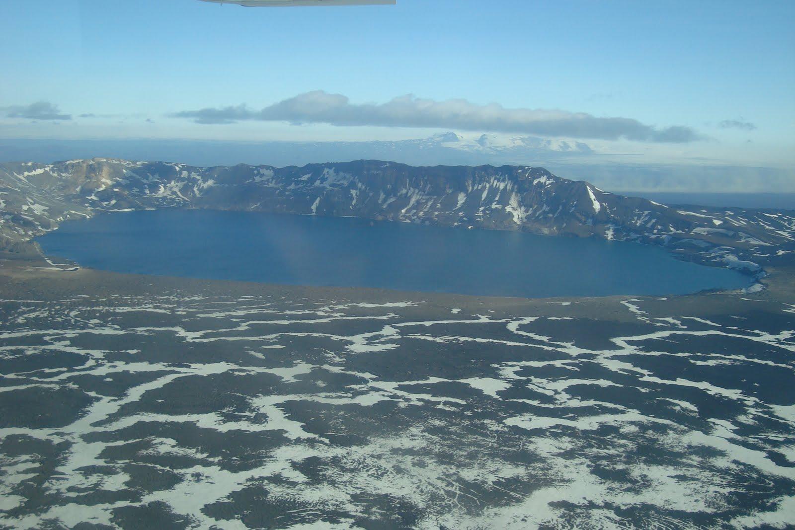
Fig. 4. “Katla’s defrosted twin”, Askja. Aerial photograph inside and above the Askja caldera with Lake Öskjuvatn and the miniscule crater Viti barely discernible on the near left-hand side of the lake. (uwmyvatn blogspot)
This too is what I believe must have been happening and is going on at Katla. Sturkell and his co-authors in their 2009 paper “Katla And Eyjafjallajökull Volcanoes” note that the products of Katla’s eruptions are bimodal, comprising alkali basalt and mildly alkalic rhyolites “with intermediates very subordinate”. One, or possibly more magma chambers where magma collects, fractionates and grows more silicic, a process that takes hundreds if not thousands of years which is why more than one magma chamber seems to be required in order to account for the relatively frequent eruptions of Katla, until there eventually is an eruption of “mildly alcalic rhyolites”, accompanied by tens to hundreds of smaller, alkali-basaltic eruptions which due to their location under the ice in a watery environment, gouge out small craters and fill in the bigger ones with mostly small, broken fragments of lava, piles of pillow lava or even small lava flows or easily eroded cones. When a big eruption occurs, the glacier first closes the wound, then the crater gets back-filled with loose rubble which gets pasted over with more solid lava flows from later eruptions.
This process has been going on for as long as Katla has existed. Not only has this constant remodelling inside the crater/caldera left a kilometres-deep zone of clastic, i.e. broken or fragmented, rock mixed with water, it also in my opinion explains how the caldera was formed in the first place. This layer extends down to not much above the roof/-s of the magma chamber/-s. As freshly injected basalt from the mantle makes its way up, it will eventually encounter this water-rich zone and result in intense activity, hydrothermal at first, and if the intrusion continues, hydromagmatic. It is primarily this activity we see when we look at the tremor charts of the SIL-stations surrounding Katla, in particular the one located at Austmannsbunga, on the north-eastern crater/caldera wall.
In the next instalment, it is time to take a look at Katla’s neighbours Eyajafjallajökull and the Gódabunga “cryptodome” and try and separate their activity from that of Katla so that we can finally figure out what she may have been up to over the last few years and how likely an eruption in the near future could be.
Part II
It is now time to have a look at what’s going on and try to paint a coherent picture of what she actually is, is up to and able to do, but first let us recapitulate what we found previously:
- There is a general interest in Katla because she is and has been regarded as a very dangerous volcano by generations of Icelanders.
- The presentation of Katla in media is skewered by vested interests ranging from scientists who hope to increase their professional and/or public standing, people trying to cash in on the interest generated such as journalists and bloggers, and finally, there are people trying to increase their standing within the subculture of doomsaying and alarmism.
- Katla is a massive but relatively young volcano, located on the MAR, and formed when Iceland was covered by glaciers.
- The records include two large fissure eruptions on the NE flank of Katla; the prehistoric 5 km3 Hólmsá Fires of 5550 BC and ~22 km3 Eldgjá eruption in 934 AD. In historic times, the 1100 years or so that Iceland has been settled, there have been 27 listed eruptions (28 if the inferred minor subglacial 2011 eruption is included), 23 of which have been explosive.
- Of the 23 explosive eruptions, three have been assigned VEI 3, thirteen VEI 4 and four VEI 5.
- The four VEI 5 eruptions are remarkably alike in size at 1.2 – 1.5 km3, which is at the upper end of what Katla probably is able to do but at the very lower end of VEI 5 eruptions.
- Tephrochronology (in some cases complemented by radiocarbon dating) has identified a further 103 eruptions going back ~8,500 years, and in the few cases where a VEI has been assigned, none have been greater than a VEI 4.
- Katla does not possess a caldera-sized magma chamber.
- In order to account for the great number of explosive eruptions which involve more evolved magmas, Katla could have more than a single magma chamber.
- The available evidence suggests that in order to break through the up to 700 meters thick Mýrdalsjökull glacier, an eruption must be at least a substantial VEI 3.
- Direct and (primarily) indirect evidence suggests that smaller eruptions, mainly basaltic VEI 0 – 2 eruptions are severely underrepresented in her eruptive record and ought to exceed the number of observed eruptions.

Fig 5. Mýrdalsjökull showing the main glacier outlets, directions of jökulhlaups and areas affected. E – Entajökull, S – Sólheimajökull, K – Kötlujökull, M – Markarfljot, Ss – Sólheimasandur, MS – Mýrdalssandur. Eyjafjallajökull is to the left and the smaller glacier above is Tindfjallajökull (adapted from Google Maps).
The greatest danger from Katla comes from the very quick and extensive melting of the glacier caused by large eruptions which results in destructive jökulhlaups. There are three major outlets from the glacier: Entujökull to the NW that empties into the Markarfljot river and valley north of Eyjafjallajökull, Sólheimajökull to the SSW that empties onto the Sólheimasandur and finally, Kötlujökull to the SE that empties in a great arc east through south onto the Mýrdalssandur. What ought to be prime farmland and in fact once was settled, is nowadays an unsettled wasteland because of the devastating jökulhlaups unleashed by Katla. This is the true reason why Katla is considered to be such a dangerous volcano.
The fact that one often comes across the reference that in the days before the Hringvegur (ring road), “people were afraid to traverse the Sólheima- and Mýrdalssandur because of the frequent jökulhlaups” is another indication that smaller and unrecorded eruptions that cause only minor hlaups are far more frequent than the 40 – 80 years often given as the interval between main, and thus visible, eruptions.

Fig. 6. The foundations of the old bridge across the Múlakvísl river destroyed by the July 9th 2011 jökulhlaup are visible to the left. The new bridge was laid down a week later. (photo John A Stevenson, GVP website)
Apart from the postulated connection between the Eyjafjallajökull and Katla volcanoes, one question that always crops up is the Goðabunga cryptodome. Many volcanologists maintain that it is a part of the volcanic system of the Katla central volcano. Others, notably Sturkell and his co-workers, claim it is part of the Eyjafjallajökull volcanic system. In order to shed some light on this issue, I asked our own GeoLurking if he could make a plot of all the earthquakes from 1994 up to and including the 2010 Eyjafjallajökull eruption. The results are quite clear and do throw up a surprise:

Fig 7. E-W cross section, view from south, through Eyjafjallajökull, Goðabunga and Katla. Plot by and courtesy of GeoLurking. The “lines” formed at approximately 5, 3 and 1.1 km at Goðabunga and Katla are most likely artefacts caused by quakes being assigned a poorly defined depth. The latter, 1.1 km, is the default depth assigned by the automatic system in case it cannot compute a depth within the predetermined level of certainty and unless they are manually checked, which is not the case of every quake, automatic depth remains uncorrected, hence these artefacts.
From this cross section, it is quite clear that there is no connection between the Eyjafjallajökull volcanic system and Katla. Eyjafjallajökull has its own, well-defined feeder system from the Moho (first molten layer beneath the Earth’s solid crust) as does Katla, thus they are wholly independent of one another. As can also be seen, albeit not as clearly, Goðabunga too seems to be independent of either Eyjafjallajökull and Katla, the ramifications of which will be the subject of a later post by Carl. Sufficient to say that when we contemplate what Katla herself may be up to, we must differentiate between activity at Goðabunga and activity at Katla. Once we do, we see that while Goðabunga is more or less continuously active, Katla operates in bursts and seems to be most active during summer and autumn when the ice cap is at its, relatively speaking of an up to 700 m thick glacier, thinnest.

Fig 8. Activity post-Eyjafjallajökull. Activity at Eyjafjallajökull is minor and has to do with the system settling down after the end of the eruptive phase. Note that at a depth of 0 to 5 km or so, there seem to be three separate areas of activity at Katla. (Plot by and courtesy of GeoLurking.)
After the Eyjafjallajökull eruption, Katla seems to have entered an active phase with a suspected subglacial eruption on July 9th 2011 and several pits or craters forming on top of the glacier. This activity seems to be localised to three main areas within the caldera:

Fig. 9. Earthquake activity at Katla July 9th 2011, the day of the jökulhlaup and suspected subglacial eruption. Both the 1823 and 1918 eruptions occurred close to but just east of this area. The 1823 eruption occurred close to the easternmost red spot while the 1918 eruption was roughly at the rightmost dark blue spot below it. (IMO)

Fig 10. Earthquake activity at Katla July 17th 2011. (IMO)

Fig. 11. Earthquake activity at Katla July 21st 2011. The 1755 eruption was situated in the same area as the three overlapping orange spots.
As can be seen, there are at least three distinct areas of activity inside the caldera with the one associated with the inferred July 9th eruption well to the south. The pits formed in the glacier also align with these three areas, albeit the pits to the northeast seem more drawn out along the caldera wall and not over the center of activity. These three areas seem to tie in with the three areas of activity noted in fig 4 as do the locations of three of Katla’s major eruptions. Thus there is not a single vent, but at least three at surface distances of approximately 5 to 8 km from each other. It is equally likely to judge from Fig 7. and Fig 8. in conjunction, that at great depth, they do have a common source.
I will now present you with my personal view of Katla, but do not be afraid to disagree or draw your own conclusions (within reason please, no Katlatubos here):
Katla is a young volcano and far more active than has previously been thought. Unlike the similarly aged but much less active Eyjafjallajökull, Katla has had more time to develop her system of sills to the point where they are fewer in number than they originally were but have a substantially larger magma-carrying capacity and approach or may have reached the point where they can be considered magma chambers proper. Since cooking evolved magmas takes a long time, usually millennia in the case of cubic kilometre-sized silica-rich magmas and at the very least many centuries for intermediate magmas, it is highly likely that Katla possesses several pockets of magma capable of eruptions ranging from high VEI 3s to small VEI 5s. Not only do the times between such eruptions argue this, their wide spread of location within the caldera does so too.
The most common type of eruption at Katla is the small, subglacial eruption of a few tens of millions of cubic meters of basaltic magmas. These eruptions are not energetic enough to break through the very thick Mýrdalsjökull glacier and the only proofs of their existence are intense earthquake swarms followed by minor jökulhlaups and later observations of deep pits or craters, sometimes water-filled, in the glacier ice. My guesstimate is that there may be many such small eruptions over any given ten-year period, and possibly in the case of a period of high activity, there may even be more than one in a single year. By back-tracking and investigating old accounts over the past few centuries of jökulhlaups in the area not associated with visible eruptions, it ought to be possible to identify many of these minor eruptions.
While a larger “proper” eruption of Katla in the VEI 3 – 5 range cannot be ruled out, I find one unlikely at present as the current activity mostly is in areas already depleted of evolved magmas by geologically speaking very recent major eruptions. Also there is little sign of the uplift required on GPS. If one were to occur, the odds for one towards the upper end of what Katla is able of ought to be better in the Eastern to Northern parts of the caldera.
Finally, what we do see when we look at SIL-stations such as Austmannsbunga, located on the NE caldera rim (not a coincidence, see above), is hydrothermal activity following a period of possibly still ongoing magmatic intrusion and not signs of an imminent, large eruption.
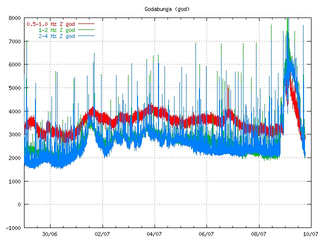
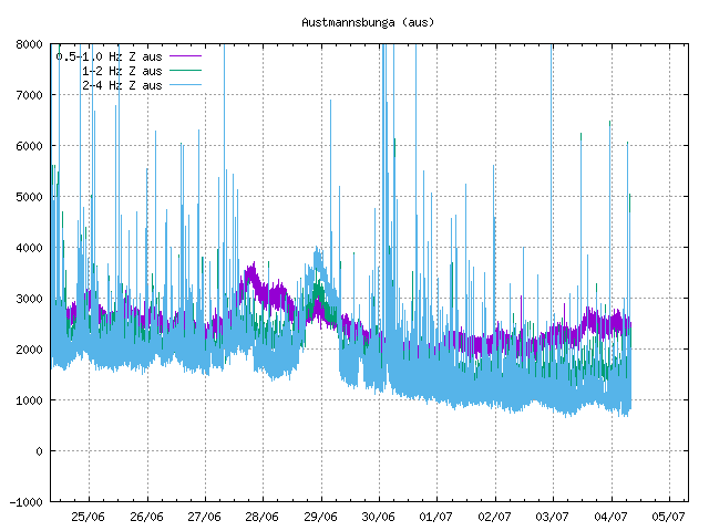
Fig 12. Hydrothermal activity at Katla as shown on the Austmannsbunga SIL (IMO) (Source: https://icelandgeology.net/?p=3291)
I’m sorry to be such a boring old fart, but if this is unsatisfactory, start looking for intense earthquake activity at some 25 – 10 km depth, showing on the IMO map for Mýrdalsjökull as being in the Eastern to Northern part of the caldera, activity that shows a clear upwards trend and spreads when it reaches depths approaching 5 km!
HENRIK, May/June 2012
Addendum
Henrik wrote this in 2012, after the burst of activity at Katla in the summer of 2011. It is now 2023 and we again had an earthquake swarm at Katla. And again it happened in summer. The activity occurred on 30 June, and was all shallow but far larger than might be expected of normal summer activity caused by ice melt. The strongest earthquake was M4.4 and around 10 quakes were M3. Not huge, but significant.
The swarm continued events from 4 May when there was an earlier swarm in the same general area. That swarm was a bit stronger with three quakes of M4. It briefly caused the status of Katla to be set to ‘yellow’ before returning to ‘green’ which it still is. That sequence was rather uncommon for early spring, normally a quiet time for Katla! Katla comes to life in summer. The last time a similar (albeit weaker) swarm occurred in Katla was in September 2016.
Was there any sign of an eruption? If we look at the tremor plot, a bump in blue line is evident on June 29. It is weak but otherwise similar to what was seen in 2011. The peak frequency of 2-4 Hz can be associated with glacial floods, i.e. increased ice melt. A magmatic eruption (bubbly magma moving up in the conduit) would normally show up equally at all three frequency ranges. However, this particular bump occurred a day before the earthquake swarm so is not directly caused by the shaking.
June 2023, Katla
It is worthwhile looking underneath the ice. Katla has a distinct caldera with a deep central depression, a steep rim which has three gaps where water can flow out, and several flow channels feeding the surrounding rivers. The ice cover reaches 700 meters thickness near the northeastern rim. About half the icecap lies above the caldera; a similar area of ice covers the northeastern slopes. The caldera shows geothermal activity. This is nicely shown by the icecap which contains several cauldrons where the heat has melted some of the ice. The hydrothermal activity is mainly located just inside the caldera rim, along the western and eastern edge. This suggests that the heated water is circulating via the ring fault. There are also two active areas within the caldera.
The ice-free caldera map. This view is from the southwest. Image from Helgi Björnsson et al, 2000, Jokull 49, 29 (https://www.researchgate.net/publication/285499559_Surface_and_bedrock_topography_of_the_Myrdalsjokull_ice_cap_Iceland_The_Katla_caldera_eruption_sites_and_routes_of_jokulhlaups).
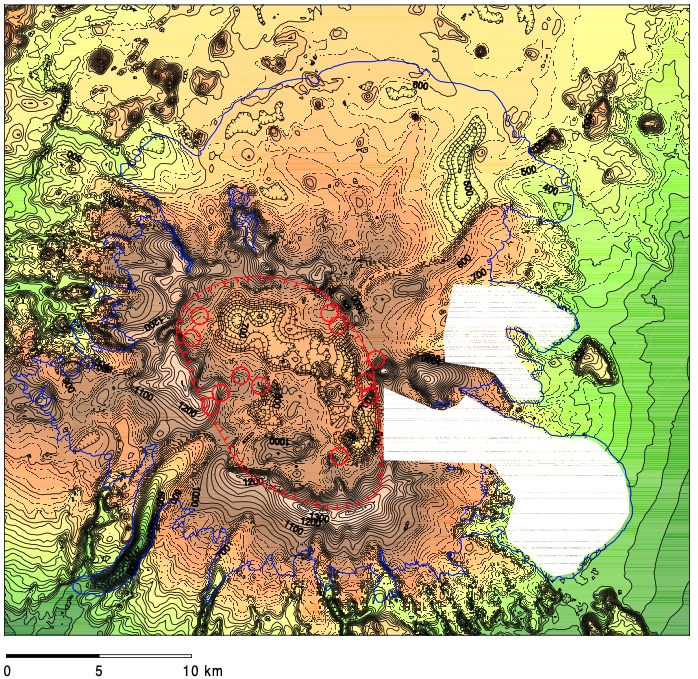
High resolution map of the caldera. The circles indicate hydrothermal activity. North is up. Image source Björnsson et al.
The recent earthquake swarm was located just inside the northeast rim of the caldera (see Jon’s post: https://icelandgeology.net/?p=11319). The swarm in May was in the same area. The caldera map shows a narrow gorge just outside the caldera, which curves a bit but generally runs north-northeast. This is the rift that fed the Eldgja eruption. The swarm was located a little south of there, within the caldera. Rest assured: last week’s activity had no relation to Eldgja!
Previous activity after the large 1918 eruption occurred on 25 June 1955, 17 July 1990 and 8 July 2011, all in the caldera. All three were hydrothermal events where magma was either not involved at all or was only a minor byproduct. Notably, all were in the summer, which clearly indicates that they were driven by summer melt: Katla is a summer volcano. We might even call it an august volcano, fitting both its size and seasonality. (The eruption of 1918 though was on 12 Oct, showing its magma is not limited by the season.) In 1955, two ice cauldrons formed on the southeast rim and a small jokulhaup occurred. In 1999, the activity was on the southwest rim with tremor and a jokulhaup. The 2011 activity was larger, with strong tremor, earthquakes in the south and east of the caldera up to M3.4, and a jokulhaup which swept away a bridge. The effect was likely amplified by the fact that water had accumulated in the caldera over the preceding year, causing uplift of the icecap.
The 2023 activity fits with these events. The location is a bit north of the 1955 event. The earthquake activity was stronger but it has not caused a jokulhaup – perhaps because the location is a bit away from the immediate drainage channels.
Was it an eruption? Or perhaps a precursor? Katla is a mysterious beast. It has much to hide – it keeps its icecap for a reason.
There is in fact no evidence that the earthquake swarm was related to an eruption. There may have been a small hydrothermal event, as evidenced by the sulphur smell around the rivers. This may have preceded the swarm. However, the size of the earthquakes and the fact they followed on from a similar swarm from two months before does suggest a pressure change around the ring fault. That could be coming from a dike or from increased water circulation. The time of the first swarm may make the first possibility more likely, at least for that event. Perhaps it was the continuation of the intrusions from the deep which happened a decade ago. If you want to know, see the second link below.

My guess for now (and it is only a guess) would be that the earthquake activity is related to (but not coincident with) a small hydrothermal event. — which may not have happened yet! This may be or may become one of Henrik’s missing VEI 0’s. Whether it will become anything more is just a matter of wait and see. Katla is still a quantum volcano – it remains impossible to predict.
Post by Henrik, May 2012; addendum by Albert, July 2023


Damned Google Maps doesn’t have Litli Hrútur or Litli Keilir marked (though both their big brothers are) …
Google maps is pretty s*it for Iceland. Try this instead:
peakery.com/litli-hrutur-iceland/map/
Take the Zoom of https://icelandicvolcanos.is/ at Fagradalsfjall
Then you get the whole family: Kistufell, Litlihrutur, Litlikeilir and in between the shield “Þráinsskjöldur” which is the flat land between all the cones.
https://twitter.com/doritoeubanks/status/1677651248621944836
A few big shallow quakes 3km north of Fagradalsfjall just now. There’ll be something visible happening soon I’m sure…
https://vafri.is/quake/?fbclid=IwAR33oDkBG7cpWKJ8Ca-6uEHi6RYRZ0w9WQdUoVA5IRzzwemvwWmBMb9QA2A#close
Looking like the eruptiopn will be here. RUV cam is right in the midst of this, and RUV also just put out that the magma is so close to erupting that none of the instruments can measure it anymore. Not sure exactly what that means or if it is just a poor translation but basically it is right there, just rising slowly. I wonder if maybe the fact a lot of the terrain is basically gravel from the glacial activity has some impact on this final ascent.
Litli Hrutur is a hill though, the eruption will probably erupt on the side of it, and the webcams both only look at one side up close, it might erupt on the other (east) side in which case it will only be indirectly visible from the Langirhyggur cam.
Is that the RUV north? Ie. http://www.youtube.com/watch?v=yJfiMhqLgTY ?
Guys, I’m so hyped for this eruption! 😀
Yes, when the camera moves to the right, it should erupt between the camera and mount keilir.
There seems to a haze moving from right to left in front of the hills, when the Litli Hrutur north cam has moved to the right.
That is a sunlight reflection. Not sure what it is reflecting off but it is part of the camera
I just wish they’d take care of that unfortunate smudge on the lens…
It is hard to predict where it will erupt. But on that graphic now there are some more red quakes and they do sort of trend a line in the same line as the dike. And, well, they are on the east side of Litle Hrutur… lol
Doesnt really mean the eruption is going to happen there, but it seems a good place to bet on, in which case that webcam isnt going to see anything unless it is unfortunate enough that the eruption beings right at the top and lava flows over it. That would be crazy to watch though 🙂
Just how solid is Kelir? It’s been around a while so must have experienced thousands of earthquakes in its lifetime causing a few cracks in the edifice.
Its less about how solid it is and more the shape, Keilir is a tall steep cone surrounded by flat ground. It isnt impossible for lava to erupt at the top of Keilir or any of the other hills but it is way more likely to erupt at the lowest spot available or pretty close. In 2021 it erupted on a mountain but it did begin inside a valley on that mountain, and last year it erupted on the side of one of the steep mountains adjacent to another valley.
This effect is very powerful, effusive eruptiosn of enormous magnitude have been divided by humble hills. Laki mountain is really just a hill, and yet it managed to divide the Lakigigar craters. Laki is a hyaloclastite mountain a lot like Keilir as I understand.
And in an even more extreme case there is a small and unnamed cone that was cut by the fissure of the 1950 eruption of Mauna Loa, and which survived unburied. That cone would have a similar structure and makeup as Keilir, if anything weaker. The eruption of Mauna Loa in 1950 was the most powerful effusive eruption ever witessed, it erupted more lava than Fagradalsfjall has by double, and did it in 3 hours. The fissure was 23 km long and erupted on the full length. The peak had an output that was in the range of tens of thousands of m3/s at the peak, higher than even the legendary start of a Hekla eruption that have been described as ‘like a nuke going off that lasts for hours’. Yet this behemoth was bested by a humble gravel hill, gravity really does rule over all in this contest.
The only time a rifting dike might avoid a low spot for a high one is if there is a pre-existing open crack to the surface, but that is about it.
Keilir doesn’t matter so much. It waits to become surrounded by lava flows one day. The question is, how solid is the shield of Þráinsskjöldur? This shield is all the even land between the cones. There can an eruption of 1km³ happen again.
The north camera has got a fingerprint. Someone has touched it …
https://twitter.com/DottirGongu/status/1677703331496468485
What is patience…
I can wait for weeks. Don’t think I need to, but still… 🙂
Lol please no…
So my take on that tweet is the magma has to find a way through the older lava from the shield volcano. Is it possible that this layer could be so intact that it prevents the eruption and the magma creates a near-surface sill?
Yeah, the upper crust is fighting back. It’s going to lose eventually.
It did not make it through in 2021 or 2022 but had to find a weak spot elsewhere.
Failure is still possible. “enten at det kommer et utbrudd, eller så stopper det” https://www.ruv.is/frettir/innlent/2023-07-08-gos-liklegt-a-naestu-tveimur-solarhringum-387314
Either we get the eruption today/tomorrow or Fagradalsfjall has fooled all of us.
This is certainly a possibility.
It’s hard to break through a solid crust of lava unlike loose tephra. I still believe that the likelihood for an eruption is 90%. The solid rock means that an eruption would commence suddenly.
Seeing another possible instance of deep tremor on the big Island. Shows on most instruments. Most likely quake is a 1.9 at 21.8 miles deep.
2023-07-08 14:10:57
Earthquake
Magnitude:1.9M
Depth:21.9mi
https://www.flickr.com/photos/143797822@N05/53032182095/sizes/z/
https://www.flickr.com/photos/143797822@N05/53032267703/sizes/z/
Mac
Sorry, used wrong option, these will work.
Mac
Finally found a new video of Piton with a working volcano: https://www.youtube.com/watch?v=_uGfX2eb9kI
It’s a nice tourist eruption: https://www.youtube.com/watch?v=czsh1ivmVI0
Big quake now!
Saturday
08.07.2023 17:57:27 63.928 -21.997 6.8 km 4.5 99.0 5.6 km NE of Krýsuvík
Right on the shore of Kleifarvatn. So not the final push to the surface but shows there is a lot of pressure in the magma still to cause distal quakes like that
My thinking is that there’s a lot of pressure all over. The specific point where lava finally extrudes is going to be random, but the general locality will follow from the sequence of quakes.
I felt this one. Was sitting outside trying to catch some sun and I thought the dog was pushing against my chair, looked around and there was no dog. I’m kinda glad I wasn’t inside. The rattling of the glass cabinet startles me each time. Hope it starts erupting soon, then the quakes will stop.
Recent 4.5 triggered earthquake at Kleifarvatn heralds eruption, says professor Benedikt Halldórsson.
“Before the eruption began in August 2022, there were three earthquakes with a magnitude of 4.5 to 5 in Kleifarvatn, all triggered earthquakes.” #Iceland #earthquake
https://twitter.com/shaksper/status/1677765067226460162
In the meantime, Katla is doing something under the ice. See https://www-ruv-is.translate.goog/frettir/innlent/2023-07-08-rafleidni-i-mulakvisl-eykst-enn-387328?_x_tr_sl=auto&_x_tr_tl=en&_x_tr_hl=en&_x_tr_pto=wapp&_x_tr_hist=true (hopefully Google translate will work okay on this post)
The higher activity mentioned by Albert in the article shows up clearly in the graphs on Vöktun page of Myrdalsjökul http://hraun.vedur.is/ja/Katla/ .
As in

The gps station Austmannbunga (on the northern caldera rim) is moving every summer a bit southwest, and back in winter. The trend is north east as the bulk of the stations.
The summer southwest move is rather fast in the past days. Maybe another sign that ice is melting a bit faster, compared to other years, due to magma intrusion in Katla’s chamber.
Thanks Rob for the update.
Decent amount of deep quakes at Katla over the last 2 weeks, hoping for more interesting developments
Probably a silly question, but may I ask what the glowing thing centre left on MBL’s Geldingadalir live panorama cam is? Headlights? Someone camping up there? Not sure of angles, but that looks to be by the first dam?
No idea what it is but I am sure I saw it earlier today or possibly yesterday so probably nothing relating to the possible eruption
Two interesting and shallow quakes hit just at and after 22:01:50 pm local Iceland time. While I was watching the 1.7 mag event ad 400 meters depth, this quake was upgraded to a 2.2 mag 1100 meter depth, but occurred right where the possible fissure line would be, then at 22:06:32 pm a mag 0 quake occurred right at the southern end of the fissure line, not too far from Fragradalsfjall cone itself at depth 1100 meter depth. I am keeping my fingers crossed.
Pretty sunset on the northern cam right now.
Greetings, all! Now retired so I have the time to follow things more closely.
And what a time to do so, yes? Fingers also crossed for a Reykjanes eruption. Everyone’s contributions here on VC are must-read for those afflicted with unending interest in all things volcanic. Thank you!
Two simple questions that no doubt give away my amateur status:
1) Comment time stamps are UTC, yes?
2) What are the two best/most likely live webcams for spotting the onset of this eruption?
Thanks in advance, and thanks to all who regularly contribute to this special community.
Iceland Time is UTC time, so we’re good on earthquake time stamps. Comments here are recorded in UTC time too, so all quake philos should be happy. In regard to best cams, see https://www.youtube.com/watch?v=yJfiMhqLgTY and https://www.youtube.com/watch?v=_q1N4J5oTSE but I have noticed that the video feed can temporarily lock up when a quake hits. Hope this helps.
Perfect! Thank you, Randall, for this and your follow up post below.
Now I get to watch, too . . .
MacRoberts, you might enjoy watching the quake action at https://vafri.is/quake/#close. I really appreciate it, and its definitely a step forward for quake monitoring. Now if I could only obtain the realtime waveforms from the seismos 🙂
One more comment, Tomas Andersson has provided some very key information about triggered quakes during this current earthquake swarm. See https://www.vedur.is/eldfjoll/eldgos-a-reykjanesi/um-reykjanes/ where the explanation is given about triggered quakes. As he carefully points out, much of what we’re seeing is triggered quakes from the stress field, NOT quakes from the magma pressure underneath. This is an important distinction.
I have found his comments very helpful in understanding what is currently happening.
You can scroll back through the previous pages on this thread to look for his advice and comments.
Thank you Randall for those kind words! I learned a lot during the previous eruptions and enjoy sharing that knowledge with others. I’m very happy to hear that it’s appreciated 😊
Last half hour 22:10 pm to 22:40 pm Iceland time, lots of triggered quakes occurring in the Krisuvik area, around 40 or so. Might this be an indicator of the stress field continuing to slowly climb upwards towards the expected fissure eruption? I did see 2 quakes at the southern end, which might be triggered quakes also.
Another comment, the last 1/2 hour (23:45 pm) the Krisuvik area has literally jumped out with many quakes, 160 per hour, all apparently triggered quakes, signaling that the stress field in the upper NE has increased. I will take this as an indicator that we’re getting close to our expected fissure eruption.
A lot of them are probably aftershocks of the M4.5. It’s quite a sizable quake and if it happened outside of this swarm it wouldn’t be a surprise to see a lot of aftershocks.
This whole episode was preceded by a large {>3) quake at Krysuvík at the end of 2019. Also upkicks in activity during the last eruptions where preceded by upkicks on the Tromlurit plots for stations between Kri and Faf. Don’t know how they are related (fault system between them responding to magma moving along the dyke/dyke formation?).
Some interesting infrared shots here https://youtu.be/yG1OKN40V3E
It was a very sunny day when he took the shots. Do different rocks heat up differently in the sun? Be very interesting to see what the rocks / hotter areas look like when it is not quite so sunny (heat-wise and any changes in shape).
He was aware of the differential heating of rocks. Interesting that he found the steaming areas too.
https://twitter.com/DottirGongu/status/1677939695731240963
Yes. Some can heat up enough to fry an egg on in non-volcanic areas.
4.2 earthquake near Keilir which was felt in Reykjavik 7:26 today Icelandic Time.
Does the Dyke behave like a temporary graben that pushes all sides away?
I went to the RUV camera to see if it shook at that time. It didn’t but the clock stops and 8 seconds are missing when it resumes.
Meanwhile all the stations around Kilauea caldera are inflating again. Since 6/21 the Electronic tilt rose from -6 to +6 microrad.
The Iceland drumplots for the Peninsula are beginning to show some interesting – if small – signals. Gases and fluids on the move after the cracking. I’m thinking we might see a breakthrough and eruption beginning in the next 36 hours. But that’s only the guess of your local dimwit!
The scientists of IMO are discussion whether magma accumulates at the spots of the most recent earthquakes. The earthquakes can be a consequence of the accumulation.
I’m thinking about whether the red spot in front of the northern webcam is an early sign of increasing heat. There it also looks like a crack, but it can be an optical illusion. https://www.youtube.com/watch?v=yJfiMhqLgTY
Also the southern Webcam shows a red-brown spot on the base of the hill which may be a sign of increasing heat flow: https://www.youtube.com/watch?v=yJfiMhqLgTY
That was the area that was showing 50C high heat on the IR camera link posted above
Do you have links to those? 😀
Me? I was glancing at this: http://hraun.vedur.is/ja/drumplot/ . Smaller stations like Fagradals aren’t on it, though.
Thanks! 🙂
Anything could happen in the next 36 hours.
Standby for action.
I have noticed that the North cam is being moved around a lot mot and frequently showing fourther east of Keilir. I am wondering if that is the area where Gutn Tag in his video showed steam coming from the ground, as he did notify the authorities about the steaming area and may possibly be why they are showing east of Keilir a little more. Just pure specutation but those cams aren’t just put there for the public to enjoy.
Things might not happen just yet. To me it looks like it found a new weakness, and there’s a dike forming to the north-east of Keilir; towards Snókafell.
Not sure how others read this, but the quakes have increased in that area, and are slowly propogating north
The dyke has to fight with the very solid upper part of earth’s crust. Is it going to build a shallow magma chamber below this solid rock? A breakthrough can still be spectacular. How gasrich and explosive is the magma?
Not gas rich enough to make an explosive entry, the lava is too fluid and with not enough water. But it is probably enough to make some tall fountains especially if the eruption narrows to one spot before the rate dies down.
If you want some gigantic fountains from a normal Icelandic eruption then Hekla is the place to go 🙂
Yes, it’s time for Hekla to go off again. It did well every 10 years from 1970 to 2000.
Sadly Heckla is like my daughters husband. He is seldom good at sticking to a timetable. Heckla is currently running very late.
Thanks for posting that video Luis. It is the one showing the steaming area I spoke of above.
@naspmon
If the eruption comes on, it will occur NE of the FAF station, see the recent relocations and the void aseismic zone
https://twitter.com/tomfis1/status/1677953099263102977
Dammit, the map doesn’t show any landforms! Where is that void with respect to the camera positions, Keilir, &c.?
Earthquake density plots have been reasonable predictors for the last 2 eruptions.
At the moment they are showing SW of Kelir with the highest density. Whether this means that the eruption will occur there or the other 2 were coincidence remains to be seen.
There is the northeastern flank of the shield volcano “Þráinsskjöldur”. It’s possible that the next shield eruption will occur in this area. But I assume that it’s still a long way to got until this happens.
https://twitter.com/DottirGongu/status/1678010277168574465
It can be usefull…
Indeed, it may start when we think that it’s over …
The weather is still very good. Maybe the eruption is waiting for the end of the week of summer
It is waiting for thick fog, so we can’t see it.
Or it’s waiting until most of us are offline and miss the most exciting moments …
Similar to the sequence of events of previous eruptions
A natural disaster expert at the IMO says current seismic activity and GPS data are similar to the situation before last year’s and 2021’s eruptions.
https://twitter.com/DottirGongu/status/1678044365577416705
Earthquakes continue as scientists try to determine how long until it reaches the surface. Currently believed to be at around 500m depth. The influx of magma into the dyke/chamber is estimated to be around 54m/s.
https://twitter.com/gislio/status/1678082044469862401
https://twitter.com/EIlyinskaya/status/1678085370758537216
https://twitter.com/subglacial/status/1678084638583947264
Oct 2021 drone pic & old captions showing prominent subglacial basalt peak of #Keilir (right) around which many recent #earthquakes are clustered. Keilir is near the NE end of the SW-NE magma-filled dike, and is a likely location for an eruption.
Litli-Hrutur North is in a good spot:
https://livefromiceland.is/webcams/eruption2307_2
https://peakery.com/litli-hrutur-iceland/map/
Another harbinger – a borehole at Vatnsleysuströnd beach where the water is normally several meters below the surface and just 9 degrees C is now overflowing with water hotter than 40 degrees C.
https://www.ruv.is/frettir/innlent/2023-07-09-skyr-skilabod-sem-sa-i-nedra-er-ad-senda-okkur-thad-er-ad-koma-gos-387363
Is that near Vogar?
Yes.
Hope magma does not follow the same route.
Found the translation to English. Apparently hot water in that bore hole occurred 1 – 2 days before the 2 previous eruptions.
It would be surprising if their tap suddenly produces magma!
Probably not. Although they did have a well erupt at the Bjarnarflag power plant in 1977 during the Krafla fires …
I was thinking more of the Vogar area, not a specific tap 😀
The temperature was measured in a well used for water supply..
Hot water on tap! According to Smart Meter blurb, I wonder what the equivalent in boiled kettles that would be…?
Meanwhile the drumplots in the area are falling silent (well, for now).
Could be soon. (Dimwit perception, of course.
IMO updated their eruption page: https://en.vedur.is/about-imo/news/earthquake-activity-in-fagradalsfjall-area
TLDR: dike is shorter now and roughly spans the region between Litli-Keilir and Keiler and magma continues to rise. Now estimated to be about 500 m below the surface.
From the frettir page IMO.
Google translated.
Surface deformation southwest of Keili
Five days from the start of the earthquake
4.7.2023
Updated July 9 6:30 p.m
Today is five days since the beginning of the earthquake series in Reykjanes due to a magma intrusion between Fagradalsfjall and Keilis, just north of the location of the magma intrusion that occurred in July-August 2022 when it erupted five days after the start of that series.
Seismic activity is relatively low compared to the beginning of the ridge where the corridor runs. Yesterday evening, July 8, there were small earthquakes in Kleifarvatn, and the largest earthquake was 4.6 in magnitude. There was some rock fall in the vicinity of Kleifarvatn and Trolladyngja as a result. Rocks fell, among other things, on Krísuvíkurveg and Djúpavatnsleið.
Deformation in the area is still slowing according to GPS measurements. Latest data based on satellite images from ICEYE SAR on days 7-8. July show even better deformation in the area above the magma intrusion. In particular, they show a significant and new deformation of a surface that runs in a northeast-southwest direction just southwest of Keilis. It could be an indication of movement of fault lines due to slip caused by the magmatic intrusion.
Model calculations based on this data show that the magma lies even shallower than before, approx. half a kilometer below the surface. The calculations show that on July 8, the corridor was not breaking its way to the northeast or southwest, but, as previously seen, is approx. 3 km long and lies in the area between Litla Hrút and Litla Keilis. The calculations indicate that magma is still flowing into the tunnel below.
These measurements and results indicate that the corridor is moving closer to the surface and the most likely scenario is an eruption in the next few hours or days.
If I read this correctly, the blue line is a surface feature of a graben forming above the intrusion. Red is the best fit for the actual intrusion. The RÚV cams sit directly on top of the intrusion and any minute now there will be red stuff pumping out of the ground right in front of the norður cam when it’s pointed at Keilir.
The eruption fissure (if it’s doing a fissure) may split Litli Hrutur in two parts like Mauna Loa sometimes did with cones in Mokuʻāweoweo
Yes, that’s a possibility, but I think the deformation data strongly suggests that it will happen a bit to the north of Litli Hrútur, so it has to be a long fissure in order to split it. I think Albert placed his marker spot on. We’ll see…
How close is the current intrusion to the first one 2021?

It’s basically on the same line, starting at ‘int’ in the text intrusion and ending maybe one dash or two closer to Keilir.
Litli-Hrutur North https://livefromiceland.is/webcams/eruption2307_2
Litli-Hrutur Southhttps://livefromiceland.is/webcams/eruption2307_1
Looks like this is the place to be. Though if it’s anything like the last two it will wait until i’m either asleep or at work to begin erupting.
Last quake on the the list was 18:51 (local time there). Since then, silence. This is why I think we are almost there.
(Cue 4.2 quake at 4km down in the Keilir area…)
Naaah
I’m going to call it right now:
It’s not gonna happen guys! Go back to your caves! This thing has failed us…
(If you know what I mean 😉 )
Think we should all predict a time.
I’m gonna plump for 03:26 am (GMT).
11.29 an GMT
12:45pm tomorrow, not changing from my prediction above.
That is BST so 11:45GMT
Oh and I guess at the eruption coming up at the north side of Litli Hrutur very close to the base.
Don’t ask me why unless it actually happens there.
Which it wont.
11 July 08:46am – possibly 30 seconds later or so.
Iceland time, that is.
Just as an adage I just went over the comments from Carl’s the Happy Dyke article from 14th March 2021 (erupted 5 days later) and there was a swarm of earthquakes noted around 4/5 hours before eruption at between 1.5km depth and the surface.
9.00am tomorrow morning.
5.54am UTC
The mbl camera showed a little bit of interest in the puff of smoke I spotted the other day:
https://youtu.be/LMb66idO7DE
Well it zoomed in for about 2 seconds.
Bit of a tease, that one.
Well the de-gassing or steam seems quite busy. If it is anything more than that I would guess it would develope over just a few minutes, which thus far it hasn’t.
I agree, that steaming has been going on since I started watching 4 days ago and hasn’t increased in volume, Though it did startle me soon after dawn this morning when I thought it was red flames erupting. Sadly only sunrise turning the steam red.
A clear borehole prediction that the eruption is certain: https://www.ruv.is/frettir/innlent/2023-07-09-skyr-skilabod-sem-sa-i-nedra-er-ad-senda-okkur-thad-er-ad-koma-gos-387363
Unless it’s groundhog day …
That borehole is up north almost at the ocean. Google maps shows straight line distance from Keiler at 6.93 miles or 11 km. That seems quite a way away for hot water to flow, not discounting this as the picture is real.
Rúv News is reporting that an eruption might happen at any moment. #Iceland #eruption #earth
This camera: https://www.livefromiceland.is/webcams/keilir
Pans along a stretch of Highway 41 along the coast. For about thirty minutes, there’s a car parked on the shoulder, trunk open and people walking around the back. Sure, they could be changing a tire, but the optimist in me thinks–a drone maybe?
Well, Gylfi of Just Icelandic did say he was going to try a night flight.
We just had a massive earthquake, at least what I felt in Reykjavík.
Looked like a rockslide on Keilir
It was pretty massive.
And if you look at RUV North webcam you can see what I think is a dust cloud around Keilir. Must have caused some rockfall.
4.8 near Hafnarfjordur and a 5.1 back by the dyke at Keilir?
Saw it on the Visit Iceland camera – mist or smoke now ?
5.1 🙂 that might just about do it
Largest of the entire sequence, yes?
Sunday
09.07.2023 22:22:57 63.940 -22.140 3.7 km 5.2 50.5 1.6 km E of Keilir
still not acurate
https://twitter.com/spahn711/status/1678171639802937349
There was just a large magnitude 5.1 earthquake at roughly 0.4-0.5 km depth near Keilir! Magma is reported to be at a depth of ~500 m, with an eruption possible “any moment.” #Iceland
Updated to a magnitude 5.2 with a depth of 3.7 km.
Can’t see it any more on the IMO page. Either they are still working on it or they have downgraded it to a 4.3 with a depth of 4.9.
Sunnudagur
09.07.2023 22:22:57 63,935 -22,148 4,9 km 4,3 99,0 1,4 km ASA af Keili
Changed to 4.7 now. Final verdict?
Seems they have settled on 5.1 now.
Huh, and now they changed it to 5.4? I guess we’ll never know.
Did the difficulty in settling on a number have anything to do with magma in the area?
https://vafri.is/quake/#close is back dialing this 22:22:58 pm 2023-July-9 quake to 4.29 magnitude, depth 4.9 km, not the 5.2 which the IMO reports. Who is right? The webpage appears to have quakes reviewed, by the IMO possibly?? after a period of time.
Finally decided at 5.1 magnitude.
22:22:57 63.935 -22.148 4.9 km 5.1 99.0 1.4 km ESE of Keilir
That was a BIG one!!!
The “Live From Iceland” Keilir camera was taken off line.
Live drone feed now https://www.youtube.com/watch?v=OivAGrxLueo
Isak made some great drone flight videos from the second eruption last year. A shame he missed the 5.2 eq by ten minutes.
A dude with a drone. Live. And a beautiful sunset.
https://m.youtube.com/watch?v=OivAGrxLueo
I think the has started, right of Keilir on Geldingadalir “multi views” cam on YouTube. NEw line of small flares.
Rule of thumb: If you have to phrase it you “think” it started, it hasn’t started. Once it starts for real there won’t be any doubts. It’ll be really obvious with a thick plume and red glow.
I appreciate the sentiment of your comment, but I was around for the genesis of the 2021 and 2022 eruptions and am well aware that small fissure rows can begin at only a few cm tall with little to no ash emission at that early stage. From the distance away that this cam is from what I am observing, it is entirely plausible.
Sorry, but after seeing comments about birds flying around in circles signifying imminent eruption and newly formed dikes spontaneously hardening being entertained on webcam chats all week, I wasn’t looking to have my actual observation patronised.
Sam:
To corroborate, I did see two flocks of white birds, about a score or so in each flock flying southwest say 240 or 250 degs compass on the Reykjanes Nordur camera, about 3 minutes apart around midnight local time or so. I didn’t think to timestamp the flocks passing.
Tomas is 100% correct. Golden rule: if you have to ask ‘has it started?’ or ‘I think it’s started’ then it hasn’t started. When it starts, everyone will know it without a shadow of a doubt.
Made that same mistake once, in 2022. I thought it was “smoke” from a eruption, only to realize that it is only moss on fire. The next time I would think the eruption is starting, I would turn that “think” into a “is”, by thinking and double, triple, quadruple, etc until I am convinced (or just lay back and let the others figure it out).
Also, on that same note, Sam, if you “think” and posting it without thought, not to offend, you are just asking to be patronized.
Sorry about that. Didn’t mean to be condescending. Maybe I could have phrased it a bit nicer. There will probably be no or very little ash, but there will most definitely be a strong gas plume. I don’t think there were any fissures during 2021 or 2022 that weren’t really obvious. At least not any one that opened through untouched ground. In 2021 there may have been some fissure opening in the middle of the action that wasn’t that easy to spot.
I stand by the simple rule of thumb. If you’re not certain it started already, it probably hasn’t.
Moment Tensor for the M5.2 / 5km depth (per the USGS) shows the earthquake was mostly strike-slip with a hint of obliqueness…suggesting the quake was tectonic in origin?
IMHO, not unlike a common transform fault slowly unzipping?
https://earthquake.usgs.gov/earthquakes/eventpage/us6000kr82/executive
It is located just southeast of Keilir, it is probably caused by pressure in the dike as it us stuck from getting to the surface. I have seen lots of talk of this being a failed eruption but until the tremors die down to the background it us very unlikely for that to be the outcome. With such a high sustained supply the only way this doesnt end with an eruption is if it significantly extends the rift, which will only make the supply of magma larger in order to fill it 🙂
It is also possible for the supply to stop too I guess, but that took several weeks in the December 2021 intrusion, which was also rather smaller. The first eruption took several weeks to start too. Really I think we got spoiled by last year taking only a few days, it was in the right location to just go straight up. This time straight up is a bit harder but its only a matter of time.
Craig, the local determination from https://vafri.is/quake/#close shows 277 deg strike, 48 deg dip and 14 deg slip/rake which is different from the USGS determination. Futhermore I watched the magnitude determination bounce all the way around from 3.4 mag to 5.4 mag before finally settling at 5.22 mag.
Right now I trying to decide if the 277 degree strike meant that the earth on the east side of the projected fissure line (Keilir to near Litli-Hrutur) was actually being push up and over the ground on the west side, since the dip of 48 degs suggests some type of upward movement.
If someone can shed more light on what exactly the focal parameters for this quake means, that would be great!
No earthquakes anywhere near Litli-Hrutur or Keilir for over an hour now, only 4 EQs in the last hour in the entire Reykjanes peninsula – but FAF is still going strong.
Think we might be nearly there. Or there will be another big EQ to end the silence.
Another interesting video https://www.youtube.com/watch?v=A98Z08dTRMg from Just Icelandic
I’d like to know where the two RUV webcams are situated relative to Keillir and Litli-Hrutur. Can anyone plot their accurate locations on a map or furnish good coordinates so that I can do it myself?
Many thanks in advance!
Both seem to be placed on the northern slope of Litli-Hrútur. The norður cam pans the area between Litli Keilir and Keilir. The suður cam pans the area between Litli Keilir and Fagradalsfjall. You can see the 2021 cone sticking up in the background when it’s pointed towards Fagradalsfjall.
Its a real tease ….