Iceland can do surprises. Its main activity is in a limited number of volcanoes which can erupt anytime, with frequencies ranging between once per century to twice per decade. These are the usual suspects, including Grimsvotn, Bardarbunga, Askja, Katla, Hekla, Krafla. (Grimsvotn is the only one not ending in ‘a’.) The beasts can go small or big, and do fire eruptions or explosions – they are like a box chocolate, as Forrest Gump famously said. In the current decade, we have added the Reykjanes peninsula to the list. There are other volcanoes in Iceland, but their eruptions are much less frequent. An eruption from a volcano with a dormancy of many centuries always comes as a surprise – as we have seen with the original Fagradalsfjall eruption.

Source: Postglacial volcanism in Iceland, Thorvaldur Thordarson and Ármann Höskuldsson, Jökull, 2008
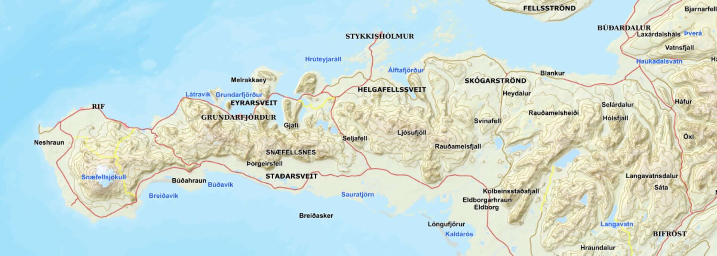
Icelandic volcanoes are associated with a number of rift zones. (The number is 9, to be precise, including the submarine Reykjanes Ridge.) These zones are some tens of kilometers wide but can run along the length or breadth of Iceland. Within the zones are the individual volcanic centres (30 in total), typically consisting of a central volcano (there are 23 of those), often with its own fissure swarms (19) which can extend for 100 km or more. Not all locations have central volcanoes: the Reykjanes peninsula, for instance, can erupt anywhere and does not revisit an old cone (other than in different episodes in the same eruption). On the other hand, a few volcanic centres have two central volcanoes.
Eruptions in different volcanic centres are mostly independent events, but as the eruptions can last for years to decades (such as in the Krafla fires – this can be seen as a single eruption or a series of related eruptions), two different systems may still erupt at the same time, largely by coincidence. There are suggestions for phases of enhanced activity across Iceland, but we have not enough data yet to know. Give it another thousand years.
Of the 8 on-land volcanic zones, the eastern volcanic zone (EVZ) is by far the dominant one. Around 70% of the known eruptions (not counting the Reykjanes Ridge where no good data exists) have occurred here. Second on the list is the northern zone (NVZ) with 12%, followed by the western zone (WVZ) with 11%. The outliers are the also-rans: the Reykjanes Peninsula (RV) accounts for 4%, and the Öræfajökull Volcanic Belt (OVB) and the Snæfellsnes Volcanic Belt (SVB) for 1% each. Finally the Mid-Iceland Belt is almost a goner with 0.1%, making one wonder whether it exists. Still, like Father Christmas, eruptions can show up anywhere. A 1% chance is not zero.

Source: Postglacial volcanism in Iceland, Thorvaldur Thordarson and Ármann Höskuldsson, Jökull, 2008
The Snæfellsnes Volcanic Zone (SVZ) is the odd one out in Iceland. It is disconnected from the other zones. The peninsula traces an ancient transform zone, 7 million years ago, which was abandoned when the transform zone moved south to form the Reykjanes peninsula. But althogh there is no longer any transform movement or rifting, it did not go fully extinct, or perhaps it re-activated in the past million years. The last known eruption here, mentioned in the Book of Settlement, was 1000 years ago.
The SVZ contains four distinct volcanic systems. From west to east, these are Snaefelljökull, covering about 600 km², Lysuskard (150 km²), Ljósufjöll (1,800 km²) and finally Snjofjöll. Snaefelljökull may have had as many 30 eruptions in the holocene, Lysuskard (around the mountain range labelled Snaefellness on the map) had two and Ljósufjöll some 20. Snjofjöll has not erupted in that time and may be extinct: it is normally left off the list. Snaefelljökull is surrounded by lava fields of a variety of ages but the youngest age is 1750 years. (One field may be a bit younger.) Ljósufjöll has a similar number of lava fields but they are not well dated. However, the report from the Book of Settlement confirms that the most recent eruption of the region was here, around 960 AD.
Based on averages, this area is now overdue an eruption. But of course, volcanoes don’t do schedules and any argument of an ‘overdue eruption’ hardly ever works. However, there is still some seismic activity on the peninsula. Micro-earthquakes up to M1 have been found under the southern flank of Snaefelljökull, at a depth of 9-13 km. These have been attributed to a local magma chamber, albeit one that seems happy to remain where it is.
Ljósufjöll
The Ljósufjöll volcanic system extends for some 100 km, from the north coast above Sejafell to the start of the peninsula. At the northwestern end, the lava field called Berserkjahraun is located. The southeastern end point is at a crater near the town of Bifröst (yes, that does exist). There is a central volcano, 1km high, which has had rhyolitic eruptions, but it has had only a few eruptions since the ice age. The central volcano has also produced basaltic tephra. It is an ancient region: the oldest dates for silicic lava are over 1 million years. (In Iceland, silicic eruptions are associated with central volcanoes and their flanks. Rift eruptions are normally basaltic.)
The Ljósufjöll eruptions in the holocene have mainly been on fissures away from the central volcano. The eruptions here have made use of older faults which allowed magma to come up and formed short fissures and small craters. These are not rifting events: rifting has long since moved elsewhere in Iceland, but the faults are still there.
The volcanic system changes appearance between west and east. In the western region, the volcanic system is narrow and well-defined: the width is only a few kilometers. In the east, the volcanic region becomes much wider, with a spread of some 20 kilometers. The western eruptions have been much larger than the eastern ones. In the east, eruptions tend to be in the valleys rather than the hills. This includes the two valleys of two valleys, Hnappadalur and Hitardalur, both south facing with lakes at the top. One may expect that eruptions here have a phreatic component. The fissures tend to be short and the lava volumes limited. The magma is alkali-basaltic, from the mantle with only a small amount of crust melted into it. The eruptions formed scoria cones.
A number of the eruption products have been dated to be between 100,000 and 200,000 years old. Four eruptions are known to be younger than 4000 years, which includes the lava with the most worrying name in Iceland, the Berserkjahraun. These eruptions were between 500 and 1500 years apart. Their basaltic composition shows that the magma flows can bypass the central magma chambers which fed the rhyolitic eruptions. The basaltic magma rose from the mantle, but whether it came up underneath the central volcano or elsewhere is not known.

Source: icelandicvolcanoes.is The pink region shows the most recent lava flow, Rauðhálsahraun
The 960 AD eruption
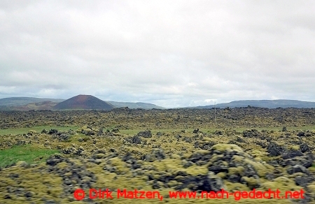
The moss-covered Rauðhálsahraun. Source: https://www.nach-gedacht.net/reiseberichte/island/snaefellsnes.htm
The most recent eruption around 960 AD formed the so-called Rauðhálsahraun. The lava covered around 13 km2 within the valley of Hnappadalur. The volume of the eruption may have been up to 0.1 km3. According to the Book of Settlement, the eruption took place in Eldborg crater, but this is wrong. Eldborg is a beautifully complete ring near the coast which erupted some 5000 years ago but not since. The 960AD (within a few decades) occurred further north, up the valley.
The Rauðhálsahraun flowed from (and is named after) the Rauðhálsar scoria cone, at the eastern end of the lava field. The cone is 80 meters high and measures 500 by 300 meters. Within the crater is a smaller crater which is over 20 meters deep, presumably from an individual explosion during the eruption. There is an ash layer associated with the eruption which extends about twice as far as the lava, and which reaches a thickness 10 to 50 cm. The eruption started with a phreatic phase, before the lava began to cover the land.

The Rauðhálsar scoria cone. Source: Haukur Johanneson, 1977, Náttúrufræðingurinn, 47, 129-141
The eruption occured during the earliest settlement of Iceland. This is clear from the peat, which changes colour from black to brown from below to above the ash layer, a colour changes that has been attributed to human activity. The Book of Settlement mentions a town (or farm) called Hripi occupied by a old man called Thorir, which was burned down by the lava. The Rauðhálsahraun covered vegetated land, and it is plausible that a farm existed there. The date assigned to the eruption, 960 AD, was derived base on the assumption that Thoris was one of the original settlers, most of whom arrived between 890 and 910 AD. After the eruption the land was no longer farmable and was forgotten. The story was therefore associated with Eldborg, impressive and much closer to the coast where it was still easily accessible.
A new swarm
This is not a likely location for the next Icelandic eruption. Carl, in the Mammoth guide to Icelandic volcanism (essential reading to find out about those Icelandic volcanoes you never heard off) gives it the lowest risk ranking of 1. Still, there is just a little brewing of something there.
Since August, there has been some earthquake activity in the region of Ljósufjöll. The swarm is located southeast of Rauðhálsahraun, between the lakes called Haleiksvatn and Grjótárvatn. This is still well within the eastern zone, in the region where the eruptions have been widespread although generally small. The earthquakes have reached magnitude 2 to 2.7, and are at a depth of around 15 km.

Location of the current earthquake swarm
The activity is not new: it seems to have started in May 2021 when it culminated with a M3 event in July that year, before diminishing. In August this year the activity picked up again, increasing to some 100 registered earthquakes during October. As of this moment (17 Dec 2024), there have been 43 earthquakes in the past 7 days.

Source: https://www.volcanodiscovery.com Earthquakes in the area over the past 90 days.
The activity seems to be on a deep fault. There is no indication that magma is involved. But in this region, the faults are an intrinsic part of the volcanic activity: the magma uses these faults to find a way to the surface. Although the activity is tectonic, the duration suggests continuing stress that is not being resolved easily.
We do not know what the precursor activity to an eruption in this region will look like. Because of the lack of shallow magma chambers, it is expected that deep earthquakes will play a role, especially if long-lasting. The build-up may be intermittent, and may last months to years or even decades. We just don’t know what to expect.
If an eruption were to occur, we can expect it be minor and tourist-friendly, although small phreatic explosions are not unlikely so the tourists should not get too close for comfort. Luckily, although the region is accessible, it is quite a walk from the main road.
But this gets ahead do the facts. So far this is just a long-lasting, minor earthquake swarm. It is just another region to keep an eye on.
Albert, December 2024
The post has made use of the information in the Catalogue of Icelandic Volcanoes, and the paper by Haukur Johanneson, 1977. Náttúrufræðingurinn, 47, 129-141, kindly translated (approximately, at least) with help of giggle.


It has resumed, no big fountain yet but no two eruptions are identical. About an hour ago from the looks of it.
There is no deflation at the summit at all though, if the magma isnt gas rich enough then it might not fountain high and just flow out slowly instead, building pressure in the magma chamber intil it can go elsewhere. There was probably a lot of degassed lava that flooded the vent though so maybe it will just take a few hours to flush it out before it goes big.
Either way, the eruption is episodic, and high fountains or not it means there is an open conduit formed again which could last a long time. That next Pu’u O’o I have been talking about might well happen up in Halemaumau instead fot the next few years, which is good for viewing 🙂
Very fun stuff indeed and this is all related to the current high input for / recent escelating magmatic influx under Kilauea thats driving all recent eruptions and intrusions and partly the leilani sourge that caused the system to overload. When magma accumulation under Kilauea is this crazy high we haves a volcano that have become magic box of quality dark chocolate bunnies it can do anything basaltic and it can do it frequently too .. anything is possible now with sky high supply
It will be fun to see how much halemaumau ( which technicaly is gone ) will be able to fill up before the magma is forced elsewhere. Its very sensitive to pressure will be fun to see how tall the lava lake will be able to rise.. perhaps will be a repeat like the 2021 – 2022 eruption that made a temporary open conduit
I miss Kilauea will not have time to visit for a long time
I think it will probably not be able to fill more than 1 km elevation, so maybe to the height of the 2023 cone next to the fountain for reference now, or thereabouts. It will probably bury all of the floor of the downdrop block but not overflow. Doing this also will take a long time, maybe years, and the rift zones are open just not apparently as easy as the summit right now.
My best guess is this vent will become semi permanent for at least a few years, maybe as a lava geyser but eventually the conduit gets too wide to do that and ut becomes a lava lake again. It might well have rift eruptions without killing this vent but pressure will take magma east long before an overflow. But thats a guess, the 2018 caldera could well be overflowing tkwards Volcano House in 2030, and dkon into the Kau desert in 2040. We are 1 day into what is probably a major event of some description 🙂
It’s interesting for sure. I think it will be difficult for fountains to get particularly high, though. Halema’uma’u has done many eruptions, even episodic ones, and with magma more alkaline than the current, but it has never managed to do very high fountains.
That is true, but we also dont kniw about exactly what went on in the early 19th century really. The majority of the tephra is probably from 1790 or soon after but without dating exactly its not possible to discount some high fountaining occurring.
Another factor is that all the eruptions in Halemaumau before right now after 1952 had to go through degassed and stagnant lake lava where now this vent is on solid ground. There were vents in the lake at the start somewhere but they are dead by the looks of it. 1952 had a short lived but huge fountain, observed diminished from its peak at over 250 meters tall. That was opening phase, this time wasnt that tall but the 90 meter estimate of HVO might be a little low I think.
As I have been writing this, the fountain actually has gotten bigger too, slowly.
The right vent of these two is the one that reopened.
Actually there is a weaker vent a bit closer to the live cam, out of view, that is erupting too. And the bigger vent closer to the southwest wall is still steaming so might not be dead either just not erupting right now.
The fountaining is really picking up in size.
Strange – we can see the old car park road still present on the dropped slab, bottom left. How things have changed!
The lava fountain on the west wall looks as impressive now (1 a.m. Hawaiian time) as on first day, again behind the dry tree: https://www.youtube.com/usgs/live
Map of eruption so far and seems the lava flowed at the September 2023 cones.
image removed for excessive size. replaced with reduced version. Please check before posting.. – admin
The area covers much of the 9/2023 lava field, but it is a shallow lava shield inside the caldera with the shallow peak near the vent and shallow slopes towards the east.
Listening to Toto Africa, while watching the eruption. Getting ready for bed. I hope all of you have a Merry Christmas and happy holidays.
Mac
The GPS cross caldera plot has shown a big increase from the eruption, probably because a lot of the lava erupted drained back down the vent. Or there is a significant intrusion but I dont remember the September 2023 eruption making a signal like this with similar orientation.
There are also waves in the lava lake near the vent and the fountain is jetting back away from the lake, so I think drainback and another pause will begin within the next 2 hours.
Also it looks like actually pretty much all of the original fissure in that corner has reopened, although only the obvious fountain has returned to the same vigor as its start. The fountain is half as tall as the wall behind it which is 800-900 ft high, so these fountains are at least 400 feet or 120 meters tall. I expect fountain height to increase as the vent matures, maybe reaching over 200 meters, or even getting taller than the caldera rim by New Years, it will be interesting to see if episodes are short like at Kilauea Iki or much longer like the ERZ shields.
Rootless lava flows would be interesting. Granted, they wouldn’t go far, but a’a’ flows in the caldera are rare.
It is the first eruptions after the collapse 2018 which has the ability to do up/down movement of magma. 2020 to 2023 all eruptions in the summit were one-way eruptions that only let magma flow up, but not down. The lava lake 2008-2018 did the up/down movement of magma regularly depending on inflation/deflation of the magma chamber.
The east side of the summit had more loss (deflation) during the last two days. Does this indicate that the magma for this eruption came from the eastern part of Kilauea (ERZ)?
The increase is the dike’s doing
New post is up! Dreaming of a Dry Christmas
https://www.volcanocafe.org/the-mediterranean-sea-salinity-crisis-salt-of-the-earth/