Let’s image the simplest, most boring volcano possible. It consists of a magma balloon fed by a straw. The ground is perfectly flat above the balloon. Magma comes up the straw at a constant rate. It would be easy to predict such a volcano. The balloon inflates until it bursts. Eruption happens. Because the supply is constant and the balloon always has the same capacity, then every eruption should be evenly spaced and have about the same size. It would be like a clock. Wouldn’t life be easy that way? Volcano tourists could catch up to a volcanic eruption just as it starts. Evacuations could be planned with time. There would be no uncertainty or loss of control over the situation. But volcanoes are not clocks, obviously, and Kilauea can tell us why.
Contrary to most scientific depictions and models Kilauea is NOT a balloon. Magma is actually stored in a vast, intricate system of interconnected chambers, conduits, and sheet intrusions. A complexity that is probably shared with other volcanoes in the world. But in this case, more active, very shallow, and well monitored.
In this article, I’m going to talk about the shallow portion of Kilauea’s magma system. As opposed to the deep system, that I’ve looked into in the past. This is the most dynamic part. Inflating and deflating, feeding intrusions and eruptions, and collapsing into craters and calderas, it is a never-ending action. The depth of the plumbing decreases slightly outward from the summit.
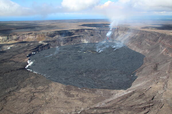
At the top of the volcano lies Halema’uma’u Crater, the beating center of Kilauea. A column of magma rises up under Halema’uma’u, often it makes its way towards the surface, making a semi-permanent lava lake, the fiery heart of the volcano. The top of this lava lake lies at an elevation of 1 km above sea level. Dyke intrusions that propagate from the walls of this great magma shaft run very close to the surface, running no more than a few hundred meters underground. The Great Crack of 1823 was like this. The Great Crack formed during a catastrophic draining of a massive lava lake atop Kilauea. Speleologists have descended into the dyke. The main passage of the 1823 Great Crack dyke lies 120 meters underground, is a crack 10 meters wide, and travelled a distance of over 30 km from the summit of Kilauea.

Peering into Halema’uma’u the main central conduit of Kilauea. From USGS.
In 2018, there was a magma chamber that collapsed. This magma body was 2 km under Halema’uma’u, or about 1 km below sea level. Actually, it may have been two stacked chambers that collapsed. First, the Halema’uma’u conduit started collapsing, it was followed by a 1.5×1.5 km area of piston collapse, then a larger 2.8×1.7 km area. There may have been deeper levels that were untouched. So maybe the magma chambers under Halema’uma’u structure into stacked levels of a Christmas tree-shaped complex.
Deeper than these magma chambers we encounter the two rift conduits. The Southwest Rift Conduit and the East Rift Conduit, which run about 2 kilometres below sea level. But what are the rift conduits exactly? A long-lived lava flow will over time, develop into an organized system of melt transport. It will grow a main lava tube, which carries material from the erupting volcano. This is somewhat like the aorta does with blood, the main artery that distributes blood from the heart across our bodies. The lava flow keeps growing through new breakouts and inflation thanks to the material supplied by the tube.
The two rift conduits of Kilauea are like lava tubes, only 3 km underground, 2 km bsl. They get the magma from Halema’uma’u, the central heart of Kilauea. This material is distributed into the two rift zones. The dykes and sills of the rift can be compared to the lava flow, some may have solidified long ago, others are still molten and can inflate or deflate, store up magma, and even evolve magma into new chemical compositions that are quite common in the distal sections of the rift plumbing (for example, the notorius Fissure 17). New breakouts of a lava flow can be compared to the new dykes and sills which grow from the rift conduit. The processes that happen deep inside a rift zone are hidden under a great thickness of rock, but are also similar to those that happen on the surface of lava flows, that we can directly observe and understand.
When Kilauea inflates with new arriving magma, if you head to the Kilauea monitoring page of the Hawaiian Volcano Observatory there, you will see how the two rift conduits flare-up with earthquakes. The conduit expands and its walls start to fracture from the pressure. Thus, when Kilauea swells with magma, the rift conduits inflate and experience seismic activity. They are hydraulically connected to the heart of Kilauea so they are very sensitive. Brief subtle reductions in the pressure of Kilauea’s central magma chamber under Haluma’uma’u, called DI events, are enough to shut off seismic activity in the rift conduits, but earthquakes will usually resume as soon as the DI event ends a few days later.
The following map shows earthquakes along the two rift conduits during selected periods of inflation. Red lines mark the fissure swarms, the directions that dyke intrusions follow. Initially the rift conduits start near Halema’uma’u, and then head southward. The summit of Kilauea (Halema’uma’u) is detached from the rift system, which, like a hungry living creature, yearns for the south flank of the mountain, the fundamental source of spreading that opens room for dyke intrusions. That is why at first the rift conduits take a southward direction, advancing for 8 kilometres in order to reach the rift axis. Then they align and run parallel to the dikes. They connect the summit with the rift zones, and because of this, some publications call them the connector conduits.

The Southwest Rift Zone and East Rift Zone conduits flaring up with earthquake activity (orange circles), dyke swarms highlighted in red. Earthquake data from USGS plotted in Google Earth.
Lets start with the southwest side of Kilauea. In this flank many dykes propagate from Halema’uma’u. There is another highly important location, however. An intrusion locus 3 kilometres south of Halema’uma’u, from which sills and dykes often start. The following map shows the intrusions from Halema’uma’u in red and from the upper rift conduit in yellow.

Circles are earthquakes made by Southwest Rift Zone dyke intrusions in 1974 and 1981, which followed the exact same path. Yellow lines are the fissures opened by the 1974 dyke, they are offset to the north because Kilauea’s dykes are not vertical but actually dip steeply towards the south/southeast. Green are fissures from an eruption in the Kamakaia Hills sometime around 1800 AD. Plotted in Google Earth with USGS seismic data.
Traditionally, it is said that Kilauea has two magma reservoirs, the Halema’uma’u magma body and the South Caldera magma body. This is the simple interpretation that I was critiquing earlier. I’m of the opinion, that we should be talking of a complex of sills and dykes that radiate from certain area. Those areas are Halema’uma’u and the upper Southwest Rift Zone conduit. The intrusion complex under Halema’uma’u sometimes coalesces into a magma chamber of variable size that can collapse afterwards.
The so-called South Caldera magma body is probably a vast plexus of dykes, sills and inclined sheets that propagate from the same intrusion locus 3 km south of Halema’uma’u that is in turn supplied from the summit. South Caldera sills have been modelled to be about the same depth a the rift conduits, 2 km bsl. The base of dykes, like in 1981, also seem to run about 2 km bsl.
Below is an interferogram (a deformation map) for an intrusion on August 23, 2021. This is one of the most convincing candidates for a new sill being intruded. It was sudden, short-lived, with propagating seismicity, and caused by inflation of a flat sheet of magma. Otherwise, it may be difficult to distinguish new sill intrusions from inflation of the already existing ones; or worse yet, from the signal of dikes intruded at the same time as the sill, and concealing the sill inflation. It follows seemingly the same path as dykes in 1974 and 1981.

Deformation map of a sill intrusion that took place south of Kilauea’s caldera between August 23 and August 31, 2021. Image from USGS.
There is yet a third location that feeds intrusions in the Southwest Rift Zone that must supply the Kamakai’a Hils. The Kamakai’a Hills are a cluster of cones that is offset from the two main fissure swarms of the Southwest Rift and that often erupts evolved basalt and basaltic andesite magma. This basaltic andesite must have evolved from some stale sheet intrusions. The location is around the distal end of the Southwest Rift Conduit. It must be a small system of sills and dykes far from the summit of Kilauea, that being in the periphery of Kilauea’s system develops evolved magma compositions. The Kamakai’a Hills may have last erupted sometime around 1800 AD (Kamakaia Waena lava flow). In the past several decades, I don’t think there has been any magma intrusion here.
The other rift of Kilauea, the East Rift Zone, is even more complicated and intriguing. Like the SWRZ it has multiple fissures swarms, and evolved magma pockets (including a pocket of dacite magma that was accidentally drilled at the Puna Geothermal Venture in 2005, some 45 km away from the summit!). But it also has unique aspects, in fact, so unique that no other volcano featurs this structures so far from the main summit, I’m talking about the pit craters, and the shield volcanoes that develop features of central volcanoes (the 1200 AD Kane Nui o Hamo, and the historical eruptions of Mauna Ulu and Pu’u’o’o). The pit craters, large collapses up to a km across, have been particularly overlooked. These incredible structures, are they collapsed central magma chambers to their own systems of intrusions? The position of the dikes, radiating in tight strands from them, could indeed suggest this to be the case. But in any case, they do appear to occupy nexus positions where the connectors meet the various dike systems.
The pit craters are found along the East Rift Connector and make up the 15-km-long Chain of Craters. They are Keanakako’i, Luamanu, Hiiaka, Pauahi, Aloi, Alae, Makaopuhi, and Napau. Some of them collapsed in the late 18th century, probably in 1790. Each seems to have its own fissure swarm. They are very small in volume; the largest two, Napau and Makaopuhi, may have at times held 0.2 km3 of magma each. They are not to be confused with the shield volcanoes. The shield volcanoes, like Pu’u’o’o, also have pit craters from their shallow shafts of magma that collapse during dike intrusions and eruptions, yet these sit atop shallow cones of magma or pyroclastic material. The pit craters, instead, have no remnant whatsoever of any sort of shield structures in their locations.

White shows the pit craters of the East Rift Zone each of which corresponds to a small magma chamber. Red shows eruption fissures of certain eruptions that were fed from these magma chambers. Map created in Google Earth.
They can also be divided into 4 pairs. Makaopuhi and Napau basically share the same fissure swarm. Makaopuhi will usually send a short dyke eastward for no more than a few kilometres, at the same time, another dyke will start growing also eastward from Napau which can reach a much greater distance of over 20 km. Aloi and Alae often work together making double dyke intrusions. The last double Aloi-Alae dyke event was in 2007 and was well observed. It will usually happen that Aloi will send a dyke westward into an elevated area known as the Koae Fault Sytem where dykes never erupt, while Alae will send a dyke eastward to lower elevations where it erupts more easily. The same is true for the Hiiaka-Pauahi pair, Hiiaka sends the dykes mainly westwards into the Koae Fault System where it cracks open the ground but doesn’t erupt, while Pauahi sends dykes eastwards, often erupting. They complement each other. The last pair or trio is Keanakako’i-Luamanu which does very small double intrusions that do not advance very far.

The Chain of Craters as seen in old aerial images from 1965, predating the Mauna Ulu eruption that filled some of them. Many of the craters are “complex” and have collapsed two or three times (in the last 1000 years). Note how very young some of them are. The imposing western pit of Makaopuhi cut lavas mapped as late-18th century (filling the bigger eastern Makaopuhi) when it collapsed, and probably dates to 1790. Given the lack of vegetation, and pre-1840 lava inside them, at least three other craters date to 1790: the inner pit of Alae, the northwestern pit of Pauahi, and Puhimau. The others being visibly older, except Kilauea Iki and Keanakakoi which I’m unclear about.

Fissure eruption next to Pauahi Crater. Photo from USGS.
When a dyke intrusion occurs in the Upper East Rift, earthquakes start near one of the craters, while immediately the summit starts deflating, there is an hydraulic connection. Within hours lava may breach the surface and gush out making fountains inside or near the crater. But it may also stay underground and not erupt. The pit can fill with a lava lake that later may perhaps drain back into the dyke. Fissures and cracks will start opening up at increasing distance from the pit crater, and as mentioned earlier, it can happen that one dyke goes west while another goes east. Such paired dyke intrusions are typical of Kilauea’s Upper East Rift.

Lava erupting into Pauahi Crater in November 1973. Photo from USGS.

There was an eruption lasting December 7–9 in 1962. The Aloi and Alae fissure swarms erupted simultaneously.

On December 24 1965 Aloi and Alae ruptured in quick succession, producing two dykes, both of which erupted. This shows the location of eruption fissures.

A typical Aloi-Alae double intrusion took place on June 17, 2007. It is best known as the Fathers Day Intrusion. Only a tiny patch of lava came out of the Alae dyke, nonetheless it is a remarkable event since it was very well monitored. Earthquake data from the USGS catalogue.
Dyke intrusions can also originate from certain spots of the East Rift that are located further east than Napau Crater. It usually takes longer for such dykes to grow and reach the surface. The deflation of the summit can also lag several days behind the intrusion or eruption start. Magma erupted first will be chemically evolved, sometimes basaltic andesites.
There is a sweet spot for magma intrusions under Honualua volcano, where the Puna Geothermal Venture is now located. This place is 45 kilometres away from the summit of Kilauea but nonetheless magma can travel all the way here through the labyrinth of magma pathways that underlie Kilauea’s rifts, although pressure changes may take several days to go or come from here if the path has not been cleaned up beforehand. This is the location where the dyke intrusions of 1924, 1955, and 1960 commenced. Honualua may have also supplied the evolved basaltic andesite that came out of Fissure 17 during the 2018 eruption of Kilauea. Small earthquakes have been happening at this location ever since proper seismic monitoring was established.
In 2005, while drilling an injection well at the Puna Geothermal Venture on Puu Honualua, a pocket of dacite magma was encountered at a depth of 2400 meters underground. The magma had a silica content of 67%, far higher that typical Kilauea basalts. It is probably related to this same focus of intrusion activity under Honualua volcano.

In 1924 there was a dyke intrusion that started from a location downrift of Honualua cone, seemingly under Puu Kii, and opened the graben shown in the map, as it extended downrift. The eruption of 1960 also followed the same path as that of 1924. The intrusion feeding the 1955 eruption started a bit further up, just uprift of Honualua. Fissure 17 during the 2018 eruption opened offset from the others and next to Honualua; it erupted an unusual basaltic andesite magma probably drawn from local magma storage. Map from USGS.
There are two other main storage areas under the East Rift Zone, probably consisting of sill and dyke complexes. One is centred at Puu Kamoamoa, which is also the location where Pu’u’o’o grew in 1983-2018 (although Pu’u’o’o itself was formed from a Napau dyke). The other is located downrift under Lilewa Cone, which is upslope of Highway 130. During the 2018 eruption the two storage areas deflated. Later, they underwent reinflation. The Lilewa area twice experienced episodes of rapid inflation (seen in the JOKA GPS), first in the two months or so after the 2018 eruption, and then in March-May 2020, plus slow gradually decaying uplift between the events. The Kamoamoa area underwent massive scale inflation from the end of the 2018 eruption until October 2020, affecting an area of about 20 x 7 km, and reaching about half a meter of uplift at the centre.

Hawaii interferogram spanning the period between March 31, 2019 and January 31, 2020. It shows inflation ongoing at three locations, the summit of Mauna Loa (A), the summit of Kilauea (B), and the East Rift Zone centred in the Kamoamoa area of intrusions and earthquakes (C). The inflation in Kamoamoa is actually the largest in terms of area, and second largest in terms of range change during the given time period. Image from USGS.

Earthquakes in 1980, those less than 4 km deep. Shows the structure of Kilauea’s East Rift Zone. Red are eruptive fissures fed from the Upper East Rift Zone’s magma chambers. Green marks fissure eruptions that were fed from lower portions of the rift. Map created in Google Earth with USGS seismic data.
Conclusion
In this post, I’ve tried to give a quick look into the magma architecture of the Kilauea volcano at its most fascinating complexity. I sometimes think of Kilauea as if it were fourteen volcanoes in one. Additionally, Kilauea itself is also in complex, possibly direct, interaction with Mauna Loa.
Kilauea is far more than it seems of the surface; it is a true volcanic gem. Sometimes, quite literally, as some of the recent fountains have shown. Happy holidays to everyone! Let’s relish the beauty of lava:

Golden volcanic glass (reticulite) from Kilauea, similar to that which Pele’s fountains have been adorning trees with, as of late. Author is James St. John: https://www.flickr.com/photos/47445767@N05/14838947530
Relevant links
The seismicity of Kilauea”s magma system
The December 1965 Eruption of Kilauea Volcano, Hawaii
Comprehensive High‐Precision Relocation of Seismicity on the Island of Hawai‘i 1986–2018
Two hundred years of magma transport and storage at Kīlauea Volcano, Hawai’i, 1790-2008


Thank-you Hector for the exciting essay about Kilauea!
I’ve often wondered why volcanic hotspots/plumes create rift zones like the ones on Hawaii and Iceland. Should a mantle plume not rather create a circular structure like a Bunsen burner?
The 2025 volcanic behaviour of Kilauea is a strong contrast to the one in 19th century with long lasting lava lakes (also 2008-2018). How can the summit produce sometimes episodical spectacular Firework eruptions like now and sometimes steady calm lava lakes? What is different in the shallow system of Halema’uma’u between the current situation and the lava lake 2008-2018?
Thanks, Volcanophil. Eventually, hotspots can create a variety of magma plumbing structures depending of the ways that the setting, supply, magma chemistry and gas content and other factors shape the way magma intrudes and how the intrusions themselves create self-sustaining structures that allow magma to reach the surface. Iceland, Hawaii and Galapagos are, for example, all of them very unique relative to each other and yet there’s not much of a circular-pattern to them.
Hawaiian volcanoes carpet the seafloor ahead of the hotspot in thick sediments, and then when the volcano grows, the weight of magma under the summit pushes away the flanks, which slide on top of the abyssal sediments. From then on, the deep plumbing of the volcanoes grow into the shape of a dike that is at the heart of Hawaiian volcanoes and the way they work.
Iceland’s rift zones have to do with its location in a divergent plate boundary.
All present ocean floors in the world were once created by divergent plate boundaries. This also applies to the ocean floor that is “burnt” by the Hawaii plume. Does the ocean floor that leaves the “birth zone” of a divergent plate boundary, keep the rift structures through its whole life?
The ocean floor that’s burnt by Hawaii, was created somewhere along the East Pacific Rise on the border between the Pacific Plate and the Nazca Plate. There do likely still exist some extinct faults and extinct rifts inside the ocean floor that can interact with the Hawaii Plume.
“All present ocean floors in the world were once created by divergent plate boundaries.”
Nope.
Large areas of ocean floor have nothing to do with divergent plate boundaries. Which bits? LIPs like the Ontong Java plateau. Created by a hotspot plume head and not by a mid-ocean ridge.
Matter of definition. The lava plateaus lie on top of true oceanic crust. A hot spot can raise ocean floor to sea level (e.g. Iceland). There are also some bits of continental crust scattered across oceans (especially the Indian Ocean) but those are not deep ocean.
Albert
Wow. Great write up, Hector! Much was learned on the intricate plumbing and history.
In a way, the entire system is a jumble of volcanic chaos.
Thanks!
Thank you Hector for a very interesting article. Do you have any idea why most of the magma came from fissure #8 after things went up and down the fissure row for the 2018 fissure eruptions series? Was that primitive lava, or older just draining out? I watched this carefully, and could not believe the amount of lava that came from #8, once it really got going. I remember things being touch and go at the geothermal facility for awhile.
Fissure 8 lava was very primitive, 12% MgO at times I think. It had lots of olivine crystals formed in emperatures of around 1300 C.
If I had to guess it was just that 8 was the vent opening when the summit collapse staryed to involve a true caldera collapse through the ring fault than just the lava lake conduit caving in as before.
Also its worth noting that most of the fissures east of 8 stayed active into June 2018 and even to July 2018 for fissure 22, which began erupting in strombolian fashion.
Fissure eruptions tend to start with a series of eruption cones, initially extending but over time focussing on just one. In Fagradalsfjall the cones were often twinned, with two close together, which were both active for some time but eventually one would extinguish the other. Not sure why that was but my guess is that there was a hard layer some 100 meters or so underground which the fissure had to break through. The twinning originated just above that layer. Just a guess. As Chad says, the old viscous lava was only early on in the Leilani eruption. Later the lava was how and fluid and clearly came fresh from Kilauea.
Thanks, Randall. As Albert mentioned, it’s what fissure eruptions normally do, focus into one vent, likely because it’s hard for the magma flow to keep the dike molten, so it focuses into a pipe. Probably in a location where the dike was particularly wide.
Etna flank eruption yesterday: https://www.youtube.com/watch?v=4F4-5ijhgrA
https://www.volcanodiscovery.com/etna/current-activity.html
Are lava lakes in Kilauea’s summit the rule or the exception of Kilauea’s eruptions?
Halema’uma’u lava lakes in 20th century (according to https://d9-wret.s3.us-west-2.amazonaws.com/assets/palladium/production/s3fs-public/media/files/HVO_website_Kilauea.pdf )
1. 1927 to 1934 six short term lava lake eruptions with up to 33 days
2. 1952: 136 days lava lake eruption
3. 1967-68: 251 days
How long did lava lakes exist between 1900 and 1924 in Halema’uma’u? There are periods with “gradual filling”, but difficult to know whether it happened with a lava lake.
According to “Two Hundred Years of Magma Transport and Storage at Kïlauea Volcano,
Hawai‘i, 1790–2008” (Wright and Klein 2014) after the draining 1894 until 1906 there were only sporadic times of lava lake activity (f.e. 1904 and 1905). In the end of 1906 lava lake activity resumed and continued at varying levels until February 1924.
These ‘magma-chamberesque pockets’ are very much like mini-volcanoes, I hadn’t realised it would differentiate and crystallise to a state as evolved as Dacite. It makes you wonder if Icelandic volcanoes behave in a similar manner, Hamarinn springs to mind as somewhere that doesn’t look like a volcano but could well be a dike-fed sill (or sills) from Bardarbunga.
And not just Icelandic volcanoes – Erta Ale/Hayli Gubbi too for instance.
What happens to the Mafic minerals that are extracted from magma during differentiation? Can they be found in old magma chambers as mafic crystalls (f.e. Olivine)? The more magma loses mafic minerals, the more they must concentrate outside the magma.
This is how gabbro forms
Really nice article Héctor, thanks a lot!
The only part I don’t agree with, is the interpretation of the August 2021 intrusion being a sill. It’s got the signature butterfly pattern of a dyke, together with a pattern of earthquakes that trace the path of a dyke as suggested by the interferogram. Inside the caldera there’s subsidence, indicating that magma from the shallow storage underneath the caldera intruded in the crust as a dyke.
Thanks. You are probably right about the 2021 intrusion. Maybe not a full dike, but not fully horizontal either, something in between.
a tilted sill ..
It’s hard to tell for sure just by looking at the interferogram from the descending path (looking west). If we also had the ascending path (looking east) it would be possible to separate horizontal and vertical deformation and get a much better picture. Do note that the western lobe is less distinct, since the horizontal motion towards west (away from the satellite) cancels the vertical motion (towards the satellite).
Thanks Héctor for such a nice look inside Big Island!
There was a nice paper this week about Popocatépetl, where UNAM’s Geophysics Institute’s vulcanology department have been doing a tomography of the magma system. AP has a graphical story which I’ve linked at the bottom of this comment. But first the tomography, which neatly illustrates what you say:
https://assets.apnews.com/interactive/c2b4da2e-221b-340a-8224-c8b4f1fe7d06/dist/videos/popo_karina_3d_clip.mp4
Fascinating sills, and reservoirs and conduits. Popocatépetl is such a pretty cone-shaped stratovolcano, yet beneath the surface she looks like an artist has gone feral with blobs of orange and blue paint!
It’s nice that we can increasingly use seismic data and computer power to get internal imaging like this.
The first detailed map inside Mexico’s Popocatépetl volcano (AP, 31 Dec)
If we look at the summit eruptions since 2008, we see a clear tendency towards short, episodic and voluminous eruptions. The first period 2008-2018 had a continuous lava lake which fluctuated according to Deflation/Inflation of Kilauea, but without significant magma output. It was in fact a zero volume eruption. It was in most aspects the opposite to the current eruption style. But it was the first summit eruption of Kilauea since 1982 and a sign that the summit was beginning to become more active again.
The first two eruptions after the collapse 2020-2021 and 2021-2022 lasted long, but had low rate. They still had higher volume than 2008-2018.
The three eruptions 2023 lasted for 61, 12 and 6 days. All three eruptions 2023 had roughly the same volume. This tendency has continued during the 2024-2026 summit eruption with increasingly higher rates of the episodes and short durations. What will be the highest eruption rate, we will be able to observe? The strongest episode is obviously still to come …
I don’t think it’s possible to see the 2008-2018 lava lake as separate from the then-ongoing Pu’u’o’o eruption. Magma ascended on one side and lava descended on another, and subsequently made its exit toward the rift zone where it finally left the system through the lava tubes. If there wasn’t an exit for the lava lake, it would have continued to rise in elevation at around 4-6 m³/s (seems to be the average output at a given time) until it did find one. That the connection with the rift zone wasn’t sufficient to relieve all pressure on the magma chamber I think can be seen in how, through the years, the lava lake grew slowly higher in elevation and increased in diameter.
I have the same irk with how Kilauea Iki in 1959 and the rift zone eruption at Kapoho in 1960 have a tendency to be listed as separate eruptions. Had the Iki central vent been higher up, i.e., allowing overflow into Kaluapele (or even allowing the lava to re-occupy the lava tubes at the eastern end of the crater), I don’t think there would then have been a rift zone eruption in the first place, as there wouldn’t have been sufficient pressure build-up in the magma chamber to allow an intrusion and eruption into the rift zone. The only thing effectively separating the two was New Year’s Eve.
The one period of time where I think an eruption could be said to have had zero output for an extended period of time was during the period of the near-continuous summit lava lake in the 1800s and early 1900s, with, to my knowledge, no setup like Pu’u’o’o on one of the rift zones. Though even then there were rift zone eruptions (e.g. SWRZ Great Crack in 1823, Maunaiki 1919; MERZ-LERZ 1840, and I believe also submarine LERZ in 1924) which ought to have relieved the pressure which had built up while maintaining that lake – so technically not effectively zero output, just a large quantity in short bursts.
The 1800s lake had net huge output, but when it drained most of the lava didnt end up on land after. 1823 I think was still mostly an ERZ intrusion maybe like 1975, just some also leaked out the SWRZ (well, a lot, but not much of the total). Same in 1868 but much less erupted outside. 1832 is actually a mystery but it was probably a submarine ERZ eruption too. 1840 was a proper rifting event though, probably similar in magma volume to 2018 just most stayed underground. Even still the eruption was intense.
Its worth noting that the 1823, 1832 and 1840 drains were probably over 1 km3 of lava and recovered totally each time so input was huge. Before 1823 was probably similar too, there was no lava visible in 1794, but it was full enough to erupt on the SWRZ within 20 years, and 1790 was probably several times bigger than 2018. Only problem is for all these time intervals the dimensions of collapses and lava lake elevation/depth are pretty uncertain. But its pretty clear generally that Kilauea was extremely active tbe first 4 decades of tbe 19th century, if not more.
After the quiet period following the eruption 1982 activity returned to the summit in 2007 with unrest and 2008 with the onset of the eruption. The 2008-2018 was a first step towards summit eruptions that have continued with increasing force since 2020. Yes, the summit eruption 2008-2018 was closely related to the Pu’u O’o eruption.
The 2007-2018 era was a combination of reduced throughput to Pu’u’O’o and supply rate into Kilauea.
There was some magma bypassing Pu’u O’o into the area at Heiheiahulu and where the 2018 dike broke out from. The same area that experienced massive uplift after 2018. If anything the path to Pu’u O’o was fine just it had an option to stay in the rift, until it didnt.
2011 was also when the magma chamber fully combined into something like a melt blob, the MgO content decreased as olivine was able to settle out, DI events became common (they might be the solid material falling down the vent and temporarily stopping input).
2018 drained this magma body, compare to 1924 and 1960 that were even further east but didnt cause a full wide caldera collapse or reach the volume of 2018. But the post 2018 summit lava up to 2023 was the same as the pre-2018 lava there, so it wasnt all drained. I am eagerly waiting to see the composition of the current eruption, as I suspect it has changed over time and is now more primitive.
The amount of lava Kilauea has erupted in recent time is crazy really. To date the ongoing eruption is at 223 million m3, in a single year, with the summit instruments indicating no loss of pressure at the summit the whole time. And its not unlikely the magma supply has been about this high since late 2023, given the very rapid uplift in that time wherever magma has accunulated, and that it took only months to fill both rift zones to erupting in 2024. And going back before, the supply was somewhere at least 0.1 km3 a year since the 50s, and at times rather significantly more (1960-61, 2007-08, 2018-present). Its not really unreasonable to get numbers of over 8 km3 of magma since the 50s. If anything that may be a significant underestimate.
Mauna Loa seems not to really control this. It has inflated rapidly in the last 3 years too, and had no affect in the 70s and 80s. There is a connection to Kilauea but its far more complicated than just swapping the magma. Mauna Loa is bigger as a mountain but Kilauea is bigger as a magma system, which is usually ignored in comparisons…
And then theres the Pahala magma, which is just a wildcard and who knows what might happen there. But the current eruption recently doubled the SO2 output before E39, with no other changes, so it may be that some very primitive stuff is getting to the shallow system. If only HVO could release composition data…
The daily rate of eruptions since 2020:
I 2020-2021 ~260,000 m³ per day
II 2021-2022 229,000 m³ per day
III 1/2023 279,000 m³ per day
IV 6/2023 1,333,333 m³ per day
V 9/2023 3,166,667 m³ per day
2024 E1 (14 hours) had a rate of 15.9 million m³ per day
2025 E38 (12 hours) 24 million m³ per day; E39 (6 hours) 37.2 million m³ per day.
The growing eruption rate lets the lava fountains grow. E35 measured 480m tall lava fountains. When can we expect the largest episodes?
The biggest episode could be soon, maybe even E40 right away. Right now the biggest episode is E3 because it lasted so long at 8 days, but E38 is nearly as big and only 12 hours long. E38 probably would have been the fountain height record if vertical too, but as yet nothing over 500m.
But after that its not unlikely the record keeps getting taken every other episode until pressure to erupt faster and higher breaks something. That break coukd be anything from temporary satellite fissures as in E30, up to a rift eruption. If you want to count a rift eruption as an episode that would likely be the biggest.
My bet is a rift eruption of similar style to 1919, in roughly the same area. But with how fast both rifts pressurized enough to erupt in 2024 either is possible.
Can the increasing gas pressure change the episodes towards more explosive behaviour? F.e. a Vulcanian to Sub-Plinian eruption combined with lava fountains?
Another possible scenario seems the occurence of satellite vents to the current vents in the summit region. 1986 did a comparable shift of the eruption from Pu’u O’o to the satellite vent “Kupaianaha” 3km to the northeast. Where does the current shallow magma system allow the occurence of satellite vents?
Its not unlikely to force open a flank vent at some point. Whether it overflows before is a bit of an open question.
As for subplinian, its unlikely if based on historical precedent. But theres a possibility, and if theres any chance its gonna be with the current vent setup. One notable thing is E38 deflated the magma chamber all the way back to its lowest since the eruption began, starting from the highest point. So it is possible for the summit eruptions to fully relieve pressure in the magma chamber, which is what plinian and subplinian eruptions do but until now Kilauea never did before historically.
Kilauea has done vulcanian eruptions before, it was in 2018 and 1924 when the vents caved in and degassing magma blew it out. For ages the 1924 eruptions were considered phreatic but thats not the case, there was no water involved.
2023 there were several vents around the lava lake. Can they revive again as satellite vents of the current eruption?
An example not far from the current twin vents is the 6/2023 vent on the caldera cliff. It’s probably already buried by lava and tephra, but looks like a predecessor to the ongoing 2024-2026 eruption: https://www.usgs.gov/observatories/hvo/news/photo-and-video-chronology-kilauea-summit-eruption-photos-prior-june-19-2023
 ?itok=GYNztxPc
The position wasn’t far away from the current vents. But is the path still open for magma?
I mean not really, not truely reopening the vents of past eruptions since 2020. But there was a fissure on the wall a few months back, in about the same spot as the June 2023 vent though maybe coincidentally.
It is very likely at some point more flank vents open. Compared to Pu’u O’o this has made it through 39 episodes and only spawned flank vents in 2 of them, Pu’u O’o spawned flank vents in at least 1/3 of all its fountain episodes, and only failed after 3 years doing that, and 150m of extra elevation gain at the vent itself. Most likely its because Pu’u O’o was on a rift zone and the current vents are not directly.
One interesting possibility is if at some point an intrusion goes under the most recent lava and actually links the vents with the liquid lava in Halemaumau. There is a spot now at the center of the caldera, which I think used to be the 2022 lava lake, but is now only a weak spot in the floor, allowing lava to drain under the crust from above. But at some point the main vents intrude under the floor and spawn many spatter cones and lava ponds in the main part of Halemaumau. This may or may not be associated with fountaining stopping. It also might not happen until the vents built higher than the caldera rim but thats on track to be later this year so…
It is a good point that the old lava lake (not that old, really) is still there, now deeply buried and presumably having turned back into a magma chamber. It will take decades to solidify. That lake may be playing a role in the current phase of the eruption. I expect that HVO would not be too keen to place lots of seismographs inside the caldera!
I think the “old” lava has already reached the surface a few times during this entire eruption, which are the resurfacing events at the east side of the lava plain. It has even happened once Ep. 39 was done, the lava from the vents barely at the other side and yet lava resurfaced for about a day before cooling off…
Pu’u O’o had three main stages:
I 1983-1986 episodical eruptions, often fissure eruptions and tall lava fountains on the Pu’u O’o cone.
II 1986-1992 “nearly continuous effusion of pāhoehoe lava flows” and lava tubes on Kupaianaha 3 km away from Pu’u O’o. It was a satellite cone.
III 1992 – … the return to Pu’u O’o with the calm and effusive style observed on Kupaianaha.
Why did the second stage escape 3 km away from Pu’u O’o? If the summit does an escape eruption 3 km away from the current vents, the location may be the upper SWRZ, where 1971 and 2024 tiny eruptions happened. Can the SWRZ do more voluminous things than historically?
Much of upper SWRZ around the vents of 1971 and 2024 was buried by lava flows from Observatory Shield. If the current eruption becomes a shield eruption like this with possible satellite vents on SWRZ, it may flood the SWRZ with lava like no historical eruption did.
Observatory Shield eruption was 1000 to 1400 AD and left many deposits in the summit region, also on places where traditional historical lava flows didn’t occur (f.e. the lava free zone 5 in HVO’s classification).
Kupaianaha and Mauna Iki were more degassed lava intruded under pressure. In 1919 it was because Halemaumau was very high lava level. In 1986 it was because Pu’u O’o vent was 160m above the surroundings (summit another 86m above that) and it collapsed when it dtained, so the vent was too wide to resume high fountaining when Kupaianaha stopped and eruptions resumed at Pu’u O’o.
The current vent might only be stopped from fountaining by a similar collapse, requiring a flank eruption.
There were some vents in the old lake on day 1, but ever since then all input into the lava lake has been surface lava draining through the crust. If the vents were connected then the whole crater floor would inflate and drain each time, and with small spattering vents all over as new gas rich lava is added. Which isnt happening.
Basically if new vents open its going to be obvious
Mauna Iki happened at more than double distance from the caldera than the 1971, 1974 and 2024 SWRZ eruptions.
Where in SWRZ is a flank eruption to the current summit eruption most likely?
Can the massive SWRZ intrusion of 2024 still play a role in a flank eruption? It had a very high volume, comparable to the high eruption rate 2025. https://www.volcanocafe.org/one-year-of-kilauea-activity-enormous-inflation-rates-five-dike-intrusions-and-the-awakening-of-the-erz/
Theres kind of of too many variables why eruptions happen where they do but for eruptions on the volcanic SWRZ its related to the lava in Halemaumau, it was higher in 1919 so had more gravitational potential.
Eruptions of dikes that start from the SWRZ connector are the same as on the ERZ, and only somewhat distantly related to Halemaumau. The 2024 SWRZ vents are still at a higher elevation than the currently active vents today let alone the 2024 Halemaumau floor, so theres evidently no hard limit set by gravity like there probably is on the Mauna Iki crack/rift.
Its still unclear if the current setup is able to directly intrude the SWRZ. No dike in Halemaumau since 2018 has gone past the ring fault at all, and the area right under the active vents was a fault block. So despite similarities it might actually be very hard to have a connection. If this is the case, its most likely a flank eruption will be from one of the rift connectors proper, and with an open vent relieving pressure the actual elevation of the vents might need to be much higher to get enough gravity to intrude. So a rift eruption might not happen until the vents are even taller than the rim. Which is in fact probably going to be this year anyway at this rate 🙂
Pu’u O’o was the only major volcanic shield that appeared on Kilauea historically. Since 1790 the summit hasn’t produced a shield cone like this. So we don’t know, how a shield eruption on the summit would unfold. Maybe we’re just experiencing the I stage of a new summit shield eruption.
We can expect that the summit will behave very different during a shield eruption (like Observatory Shield) than during historical times.
Mauna Ulu was also a shield eruption. There the shift from the episodical tall lava fountains to steady lava lake and flow activity happened without an escape to a satellite cone. So it’s possible that a shield eruption of Kilauea switches on the solid location. But both Mauna Ulu and Pu’u O’o returned effusive activity to the vent that first had the effusive-explosive episodic activity.
Halemaumau in the 19th century was a lava shield too, at least it was after 1868, and it was still like that up to 2018 in shape. Whether it started with high fountains like today is kinda unclear, because it apparently wasnt observed well. The golden pumice, and eastern pumice, are big fountain fallout deposits in the age range but might be from late stages of the 1790 collapse too, rather than a new vent opening.
Its also worth comparing 1959, because that was also a fully open vent that was erupting in episodic lava geysers. Same as Pu’u O’o and Mauna Ulu. Only that in 1959 it happened right adjacent to a deep lake with no separation, so drainback was unavoidable and the pressure increased very fast causing a flank eruption, very far down the ERZ too.
There is also tbe question that is probably impossible to answer, how many times the summit overflowed before 1500. Aila’au shield was one specific vent, and seems to have been erupting continuously although maybe not overflowing continuously. But the Observatory vent flows cover a wide age range, from like 1100 to under 700 years, and a huge area to both oceans on the north side of both rifts and much of the Hilina pali too. To me that sounds like multiple eruptions, multiple lava shields. Its pretty likely the modern trend of the SWRZ through Halemaumau and Kilauea Iki existed then too, with a line of lava structures and maybe pit craters from Aila’au that still exists now going over to the southwest rim, and continuing to Cone Peak.
Theres an old lava shield near Mauna Iki too, although it predates the youngest overflows. But its likely related in some way.
19°18’34″N 155°23’59″W
The summit eruptions 1790 to 2018 didn’t creat a shield cone that rises above the caldera rim. No summit eruption has sent lava flows from the summit towards the flanks. Even Kilauea Iki’s lavas stayed completely in the depression.
A major shield eruption of the summit may bury parts of SWRZ and do an ocean entry comparable to Pu’u O’o and Mauna Ulu. If the current eruption is the onset of a summit shield eruption like this, the location of the vents will also host the future shield cone and lava lake. From there lava may flood the SWRZ, accompanied by subterranean magma flows that erupt on SWRZ.
223 million cu m means nothing to me. I measure clothing on a meter scale, maybe buildings.
Its 0.223 cu km on a scale of a mountain perhaps 30km x 30 km x 10km or 10,000 cu km.
So these rates are really small percentages (often exciting none the less).
If you want its maybe easier to imagine 0.223 cu km as plating 233 sq km 1m deep or a square 15km on an edge 1m deep. These are useful handles.
Personally I prefer units of km in a situation where most things (like mountains) are measured in km!
It doesnt matter that way, its better to just compare it to published numbers of supply rate at most volcanoes, which are always either given in millions of m3/year or in m3/s.
The other way to look at it, the global magma budget per year is about 30 km3 a year, of which most is plutonic at plate boundaries. Maybe only 5 km3 is actually erupted, and thats gonna be largely underwater. Kilauea, at least recently has been responsible for about 5% of all volcanism on the planet with that number. And probably 10-20% for subaerial. On average anyway. Its not always this high but its rare anywhere else other than Mauna Loa is more active for any length of time. Other comparable complexes contain clusters of separate volcanoes that need to be combined, which is kinda cheating.
If you want numbers, its a 1km square 223m deep. Or a 100km square about 2m deep. If it does this again this year the caldera may start to overflow, depebding on how high the vents get.
Units work best if the actual number comes out near one (between 0.1 and 10) since that remains comprehensible. The difference between meter and kilometre is a bit too large for us, and of course with volume that become much too largeL 1 km3 = a billion m3. Unfathomable numbers. (A fathom is taken as 2 yards but there were different definitions around – so a fathom is also unfathomable.) For eruption rate, m3/s works best. For total eruption volume, I recommend km3 if the number is 0.1km3 or more. Below that, km3 and m3 are equally hard to interpret so pick your choice. Please, please, avoid olympic swimming pools at all cost. Anyone using that as a unit should be banned from math for life.
I miss the applying values for Are and Hectar in volumes. They do exist, but are usually not used: https://en.wikipedia.org/wiki/Cubic_metre#Multiples_and_submultiples
The current eruption of Kilauea has had a volume of 223 cubic hectometres. But who knows hectometres?
In the UK, acre is still commonly used. We could define a unit of acre-kilometre: the amount of lava needed to bury one acre to a depth of 1 km. That would make the Kilauea output just over 50 acre-km. Over to farmeroz ..
The are and hectare are an abomination of a non-si unit.
Acres are fun but archaic.
I do somewhat disagree using m3/sec either. Good for a decent waterpipe but not for something expected to cover sq km. Its a problem that cubic anything gets big/small rather dramatically, and perhaps some thought there would be worthwhile, but would probably not come to anything. I think the easiest is to stick in km^3 but vary the time. A fast eruption might be in seconds/minutes (OK REALLY fast), slower one is days or years. Using m^3 is even worse than olympic swimmingpools although the latter are at least more in the right ballpark!
A typical effusive eruption does a flow rate of 1-100 m3/s. That seems ok number wise. Initial values may be 10 times higher – that is harder to comprehend. 100 m3/s is 3 km3/year, so that unit (km3/yr) should also be ok in many cases. At the other end of the scale, Toba did 1 km3 every ten minutes.
Expressing volumes in Hectare-Kilometers would simultaneously be intensely uncomfortable and a somewhat reasonable middle-ground in terms of visualization. 1 Hectare-Kilometer would be 0.01km^3, but 10,000,000m^3.
We could also go a step further and try to define a “Volumetric Hectare” (1 million m^3, or 1 Hectare filled up to 100 meters), which apparently doesn’t have a name.
I’m not saying that we SHOULD do either of these things, but the explosion in scale caused by cubing does make visualization difficult.
Actually Hayden has probably hit the ideal. I think my problem is the use of million. Perhaps mega meters cubed possibly confusable with cubic megameters, or is that mega cubic meters, isn’t too bad. The entire problem is that cubic (and even square) SI units are confusable with linear ones particularly when numbers get high. A cubic version of the hectare would actually be an SI unit (being a million cu meters) and thus a power-3 of the base unit. Its also easily visualisable as a Ha filled 100m deep or …..
I think it should be called an Albert, or perhaps a Hayden?
An eruption of 270 Alberts has a certain ring ….
I think it would make an excellent local unit for this group!
With this rate (0.2km³/year) Kilauea would do the Pu’u O’o volume of 4.4 km³ within 22 years.
But: Pu’u O’o was also very productive during the first three years: In December 1985 they wrote: “Lava has covered 39 km2 since January 1983, and the total volume of lava exceeds 0.46 km3, surpassing all historic eruptions of Kīlauea.” https://volcano.si.edu/volcano.cfm?vn=332010#bgvn_198512
This means that the yearly rate of Pu’u O’o was at 0.153 km³/y. 1983 had 0.140 km³/y. This was 62.8% of 2024.
Pu’u O’o also caused a net deflation until the mid 2000s, when the supply rate overtook the eruption rate. Its also probable the 2008 lava lake is a result if this, and having this open vent might be the main reason Pu’u O’o had apparently reduced output, because it was already degassed at the summit after that point. Also some accumulating in the rift zones, and growing the magma chamber.
By contrast now both rift zones are pretty weak, supply is very high and possibly accelerating.
Can the summit do an ocean entry like the Pu’u O’o eruption? A volume of 4.4 km³ or larger should be able to reach the ocean from the current position of the vents. The current rate allows an eruption that exceeds Pu’u O’o. Added to this the SWRZ may act as a satellite rift zone to a major shield eruption of the summit. We may get a hyperactive SWRZ.
Yes, summit overflows have reached the ocean every direction multiple times in the last 1k years, flowing over 40 km, and for years at a time
If the summit overflows in the current fountaining state, it will send huge fast flowing a’a flows down the south flank and into the north of the caldera, possibly even into Kilauea Iki. Mauna Ulu and Pu’u O’o sent flows up to 14 km away with similar volume and lower eruption rate than the current episodes, even one time into the ocean 13 km away in a few hours in 1969. If it overflows continuously at current rates an ocean entry is almost certain within a month.
I have made a prediction Kilauea will do another ocean entry before August 2028, the 10 year anniversary of the end of the 2018 eruption. Most of the caldera wont make it that far…
Pu’u O’o and Mauna Ulua show that the calm steady stage(s) dominate the period of Kilauea’s shield eruption. It’s possible that the current fountaining stage shifts towards the lava lake & flow & tube stage, before the summit overflow happens. We’re in sprint stage with voluminous, but short flows. Afterwards we’re going to possibly get a marathon stage with long distance lava flows & tubes.
I imagine a lava lake inside a growing shield cone on the position of the current vents, maybe on an altitude of 1150 meters above sea level; and additional +100m of the cone’s peak. From there might go a “spider web”-like system of lava flows and lava tubes. The SWRZ may act like a satellite system to this summit shield eruption with repeated flank eruptions.
I expect that when the current eruption series ends (whenever that will be!) Kilauea will have a recovery phase. If it ends with a rift eruption, then the recovery could last some time. I wouldn’t want to put numbers on it though. Volcanoes don’t like that.
First we will have the next episode of Kilauea Place (next week?). Followed by Reykjanes Street. A prediction, not a promise
Kilauea wont go to sleep unless Mauna Loa is taking its place, and theres more evidence against that happening soon than for it.
There is also the magma under Pahala and if the structures it is composed of are anything like claimed, that will take decades to centuries to erupt at any rate that is not potentially catastrophic…
The complexity of the Kilauean magma system is the only thing I find interesting about it.
Good job, Hector.
Thanks, I’m glad I sparked some Kilauea interest!
What do the green quakes between 10 and 20 km below SWRZ show us? They appear somewhere between the deep blue Pahala earthquakes and the shallow quakes south of upper ERZ.
Could be nothing but… I’m seeing a lot of microseismicity at Sundhnúkur, on the DAS plot. I haven’t seen that for a long time:
Finally.. Although I can’t see your image as imgur is not available here
Just use a VPN and put your location outside UK.
what is the web address of this DAR plot, thanks
It’s on youtube on IMO’s channel. Unfortunately, it’s currently offline:
https://www.youtube.com/@vedurstofan/streams
Looks like something has changed/shifted a bit
IKI tilt and also SMS had a shift in the trend. Shooting up by around 3 Micro rads in a day or two. It has also caused a change in ESC tilt further down the rift zone that mirrors those station’s change.
https://www.flickr.com/photos/143797822@N05/55028611921/in/dateposted-public/
Mac
ESC
There’s been quite a lot of precipitation the past few days around Kilauea, which probably explains the tilt shift at ESC and IKI (and definitely at POC). The summit itself seems to be undergoing a D/I cycle (looks about to go to inflation; it’s already at that point on SDH), which should mean tilt will shoot up and be within a day at the point where it should have been if there wasn’t a D/I. It’d also bode well for the interval between E40 and E41, as the increased inflation rate holds for a few days at least – and even a week or more this eruption if memory serves me right – so the interval should be shorter.
It looks like magma leakage into or towards the upper east rift zone. Instruments on the southwest show little, but it is pronounced towards the northeast as a DI event in the northern caldera, and very strong at ESC in the southeast as sudden inflation. No significant seismicity, so not a new dyke.
Maybe it indicates a relatively weak inflation on the northern part of the magma system (UWD and IKI), while the southern part looks more healthy. There is likely the main magmatic feeder for the ongoing and future eruption:
The leakage has poked it way down to the Middle East Rift Zone…
 ?fileTS=1767813824
 ?fileTS=1767814174
But not as far as the JKA further down…
HVO has pointed out that there has been heavy rain in the area. That can affect tilt and gps quite a bit. Best to disregard these data.
On the Campi Flegrei December report from the Observatorio Vesuvio at https://www.ov.ingv.it/index.php/monitoraggio-e-infrastrutture/bollettini-web
“Starting from October 10, 2025, an increase in the rate of ground uplift was recorded, with an average monthly uplift value of approximately 25±3 mm/month. The uplift recorded at the RITE GNSS station is approximately 160 cm since November 2005, of which about 22 cm have occurred since January 2025…The geochemical parameters confirm the multi-year trends of heating and pressurization of the hydrothermal system, showing a significant increase in recent months.”
At the GOSSIP site https://terremoti.ov.ingv.it/gossip/flegrei/2025/index.html
There was a 37% increase in all earthquakes from the 2024 record year, rising from 4899 in 2024 to 6733 in 2025.
In 2024 there were 25 earthquakes with magnitudes >=3.0 including one M4.4.
In 2025 there were 34 M3.0 or higher and a whopping 5 fold increase in 4 magnitude earthquakes with two M4.6.
For gits and shiggles, I looked back to the Seismic Crises of 1984 hoping an apples to apples comparison to 2025. Obviously, the seismic network is now far superior to back then, but if we just just considered M3.0 and greater, we should get pretty close.
Surprisingly, the 2025 number was of 34 is only four less than the 38 in 1984 when the greater Napoli metropolitan area thought the world was coming to an end. Even more impressive is that there was only one M4 in 1984 versus the 5 in 2025.
When you convert those earthquakes to energy, 2025 blows1984 out of the water…quite literally, at least in the Gulf of Naples…
Do we have data about Vesuvius’ deformation since 1944 and now? There were many small earthquakes that were part of “caldera setting” after the eruption. But this negative “post-eruption” trend may once come to an end.
https://www.researchgate.net/publication/397817310_The_2025_Santorini_unrest_unveiled_rebounding_magmatic_dike_intrusion_with_triggered_seismicity
https://agupubs.onlinelibrary.wiley.com/doi/full/10.1029/2022GC010475
https://pubs.geoscienceworld.org/gsa/geology/article-abstract/48/3/231/579527/Magma-accumulation-beneath-Santorini-volcano?redirectedFrom=fulltext
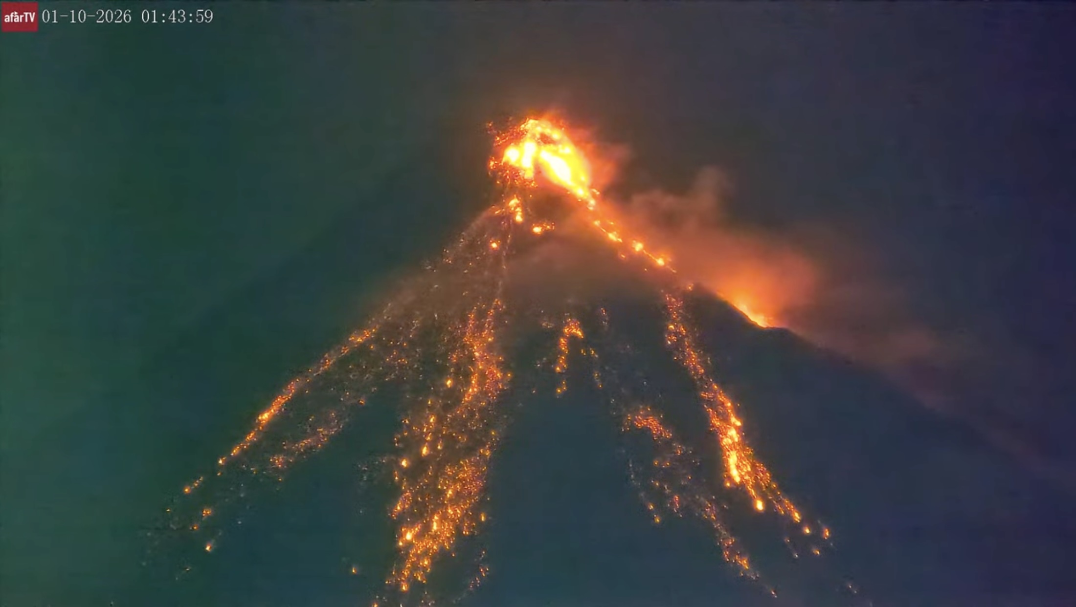
Kilauea is nicely flaming again
I am kinda surprised at VC, a decade volcano is erupting Mayon, and not even a peep in the comments.
Had completely missed it. Found a live stream. It’s like a cartoon volcano.
https://www.youtube.com/live/UDAZWxehMAI?si=CLcsR0fC_MrCZpB6
A clear view with big flows right now. The perfect cone draped with red lava on top is magnificent.
You are right! That is the most perfect volcano view I have seen.
Screenshot of the live cam
A viscous lava dome, growing and partially collapsing, over and over again in a beautiful cycle. The “flows” are more like hot rocks tumbling down than the liquid streams of molten rock we are used to from Kilauea and Iceland. It’s very hypnotizing to watch.
Its probably going to get more fluid soon, the last eruption had lava fountains and flowing lava. Its still viscous compared to Kilauea but a lot less than what is erupting right now.
Probably some stuff left over from that last eruption being pushed out.
South vent at Kilauea is starting to overflow.
The north vent just became visible, and it is slowly overflowing.
New post is Up! Again.
https://www.volcanocafe.org/up-2/
It’s interesting how people are drawn to both simple systems and complex ones for very different reasons. Games like Wordle hook players through a clean, predictable daily format, while nature—like Kilauea’s magma system—shows how misleading simple models can be once you look deeper. Both remind us that understanding comes from digging beyond the surface, whether it’s language patterns or volcanic behavior.