
Source: D. Dodge, 2023, https://www.osti.gov/servlets/purl/1992195. 6 years of located Pahala earthquakes
Hawai’i is a marvellous place for a seismograph. There is something to see every day. HVO has been at the forefront of this, and had as many as 7 seismometers already in the 1940’s.Their network has been expanding ever since. The instruments are located mostly in the main areas of activity (i.e. Kilauea and its children) but pick up anything anywhere. During eruptions seismic noise becomes deafening and it becomes hard to localize or even pick up small earthquakes, but otherwise the system gives location and depth even for earthquakes which are completely imperceptible to people or even animals. For advanced users, even the direction of the rock movement can be determined from the seismographic data. When Hawai’i shakes, even ever so slightly, HVO knows about it. Magma finds it hard to creep up on HVO.
The events follow patterns, with of course the occasional exception. Shallow earthquakes, less than 5 km depth, occur along the various rifts, and are often in response to magma movements. Large swarms of such quakes along the rifts indicate dike formation which may or may not end with an eruption. Earthquakes at 5-15 km depth are often tectonic. They may still (and often are) be caused by the pressure of magma intrusions: the rocks release the stress caused by those intrusions. They can also be part of the slow sliding of the flanks of the volcanoes, especially the southern giant Mauna Loa and the upstart Kilauea. Sometimes there are very large earthquakes, such as the M6.9 in 2018, the M7.2 in 1975, etc. These are tectonic and often associated with the southward movement of the southern flank. There is also a region where the expansion of Kilauea and of Mauna Loa run into each other, causing compression. This is the Kaoiki region which is prone to earthquakes. The strike-slip M6.6 quake in 1983 occurred in this compression zone.
Earthquakes can also comes from much deeper down. Those can be tectonic: the weight of the island causes flexure of the supporting cast of crust and rocks, causing slippage and breakage. These are the somewhat larger events (which can be M4 or M5) which can occur anywhere underneath the islands. Hawai’i is built on old ocean floor which is not as flexible as it once was.
There is structure to the island. On top is the volcanic pile, layers of lava flows. The deeper lava flows are themselves riddled with solidified magma dikes, where magma from below broke through the earlier flows on the way towards the surface. This volcanic pile extends from the very top of the volcanoes to the original ocean floor: the lower levels may contain pillow lavas from eruptions below sea level. Originally the sea floor was 4 or 5 km below sea level, but now it can be as much as 15 km below sea level, severely depressed by the weight of the island above. The oceanic crust itself is 5 to 10 km thick, taking it to 20 km below sea levels in the most depressed region. The mantle below is a mixed beast. Magma has collected just below the old ocean floor, and has solidified in situ. This has caused a region of ‘underplating’: a thick solid layer plastered to the bottom of the ocean floor. And below that is the lithosphere, mantle material which over time has become quite cool and brittle. The deeper earthquakes can happen anywhere in these layers. The lithosphere itself shows indication of being layered, perhaps also due to old magma sills which solidified over time.
Finally, there is the magic plume, the rising mantle which carries a small fraction of liquid rock with it. The heat from this plume keeps the island above water – once the island drifts away from the plume, it begins to sink and over millions of years, becomes submerged. This plume, may be 100 km wide, currently underlies much of southern Hawai’i island. The rise stops below the lithosphere, and from there the small liquid fraction percolates up, merges to form conduits and magma chambers, and eventually rises up to volcanic outlets – one outlet per conduit.
Some of the deep earthquakes are associated with those feeder conduits. These earthquakes can occur as deep as 60 km but are focussed at 25 to 45 km depth. They are often clustered underneath Kilauea, but occur elsewhere as well, not always near a volcano. There have been swarms of deep earthquakes underneath Hilo (non-volcanic), Hualalai (a slightly active volcano which had a swarm in 1929) and Pahala (non-volcanic).
Some of the quakes look quite different: they are tremor, long lasting earthquakes which look very noisy on seismographs and continue for 10 minutes or more. Kilauea can show them near the surface, but they can also occur at 50 km depth. Pahala in particular sometimes shows deep tremor, with very long period events traced to a depth of 40-55 km. It is a sure sign of liquid: when magma collects in sufficient amounts, it can slosh and oscillate. Liquid responds differently to earthquakes than rock because it is incompressible. Stamp on liquid and it will flow away but it cannot compress: if it is under pressure in one direction, it will flow in a direction perpendicular to the force. Rock can’t do that. (On the other hand, liquid can contain gas bubbles and these compress well and can reach very high pressure.) The rule of thumb is that short, sharp quakes are in rock, but long bubbly ones originate in liquid.
The Pahala swarm

Pahala is a small town on the forested lower slopes of Mauna Loa, home to some 1500 people. As so many places on Hawai’i, it started as a sugarcane plantation. As the sugar declined, macadamia nuts took over but these could not support a large community. Still, people remain, finding ways to make ends meet. There are many small communities in Hawai’i, people wanting to live free, with liberal attitudes regarding each other but also with a deeply ingrained conservatism. Hawai’i is known for nimbyism: in favour of progress and development but ‘not in my backyard’. I imagine Pahala to be like that, knowing I could also be very wrong!
To volcano watchers, Pahala was known mainly for the 15-meter deep ‘Pahala ash’, a layer left by Mauna Loa on a very bad day. (Note added: Kilauea is a nore likely cause of this Pahala ash, as noted by the commenters.) We have forgotten what Mauna Loa can do when it has a tantrum. We know the fast, voluminous lava flows racing to the sea coming from high altitude rifts, but haven’t seen its darker side.
More recently, Pahala became a volcanic home to the mysterious Pahala swarm. The region has a history of deep earthquakes, below 30 km, which have been recorded here since 1961. That does not mean that they began at that time: this is when detailed monitoring and recording started. There is very little information available for older earthquakes. There is one report of an event in Feb 18, 1933 at a depth 57 km which was near my ‘Pahala box’ (see below) (Jones, 1934, https://www.jstor.org/stable/24529493). This shows that the swarm has been here for 60 years or more.
There is one other notable aspect of Pahala. It is equidistant to the three nearest volcanoes: monstrous Mauna Loa, hyperactive Kilauea and submerged Lo’ihi, which are each just over 30 km away. This distance is also about the same as that between Kilauea and Mauna Loa. Volcanoes all over the Hawai’ian islands are on average 40 km apart. The southernmost volcanoes are a little closer than this average, but they follow the pattern that the volcanoes are regularly spaced. Pahala is the gap in this pattern: it occupies the hole between Mauna Loa and Lo’ihi.
(I am using the short name for Lo’ihi for reasons of ease of memory and spelling. Please feel free to substitute your preferred names for the volcanic features throughout this post.)
In the last ten years the activity of the Pahala swarm has exploded. Speculation about the cause is rife: why so much volcanic action (for the swarm is clearly volcanic in origin), so far from any volcano? Where is the magma coming from? And where is it going to? In the infamous words of the First Lord of the Admiralty (itself a confusing title) Winston Churchill: it is an enigma wrapped in a riddle.
Dissection
Events of the past 30 days
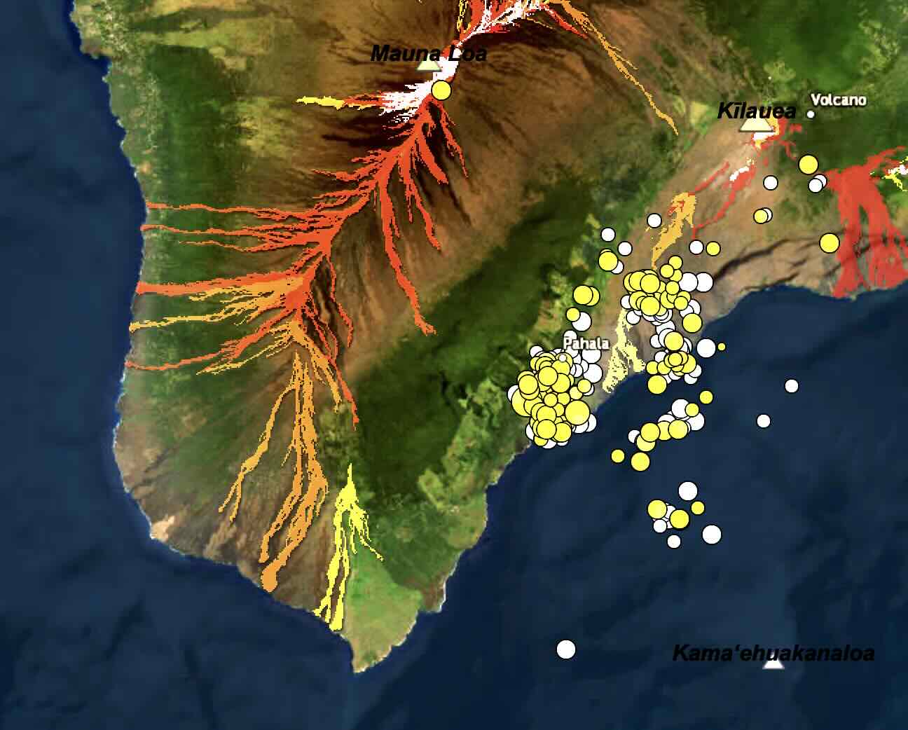
The Pahala swarm is not a single identity. It occurs in two distinct clusters, a western and an eastern one. The western one is close to Pahala itself (it is centred just south to south-southwest of the town), and the eastern one is about 10 km to the east (obviously). The eastern cluster is located below the western (that is less obvious) rift zone of Kilauea whilst the western group lies underneath the flank of Mauna Loa. There is also a third cluster just of the coast. All three clusters have similar depth and are clearly closely related, but the gaps between them are real. It adds mystery to the riddle.
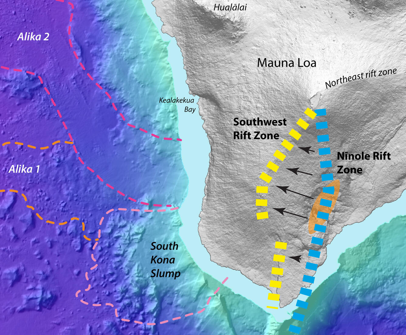
Why does the Pahala swarm not extend further west? It ends very suddenly. Here it runs into a range of low hills on the slope of Mauna Loa. These are the Ninole hills. They were at one time thought to be the remains of another volcano. Now they are seen as an older (100,000 years ago) rift zone of Mauna Loa, before this zone migrated west. The dense solid magma emplaced in the old rift acts as a blockage. Magma migrates away from it.
Ninole Hills
Numbers are up
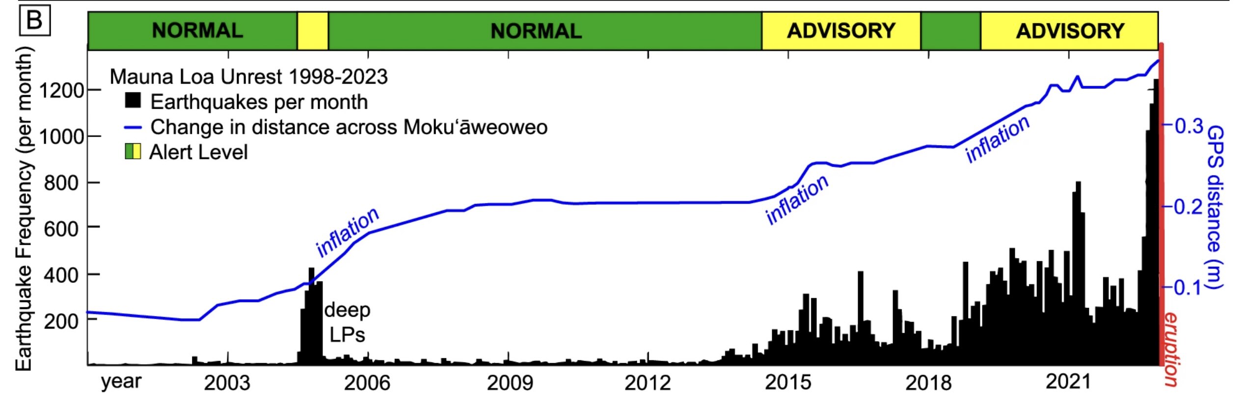
The number of Pahala earthquakes in the USGS earthquake catalog has rapidly increased in the past decade. Selecting events within latitude range [19.125, 19.231] and longitude [-155.566, -155.39], and with depth between 30 and 45 km gives a long list. (Note that the list I used goes up to 6 Nov 2024 and does not include the most recent events.) The location box selects quite a small region. This is meant to exclude events not associated with the Pahala swarm. However, the selection may miss events just outside the box or with poorer locations. The aftershocks of the M7.2 earthquake in late 1975 made detection of weaker earthquakes difficult for more than a year, but events larger than M2.5 were still detectable.

Earthquakes listed in the USGS earthquake catalogue of magnitude 2.5 or larger, near Pahala (see text for details) and depth 30-45 km.
The plot shows the number of earthquakes in the list per year. It started at low levels of 10 or less, with a slight bump around 1975-1980. This bump may not be directly comparable with modern numbers since the monitoring is much better nowadays, so it is possible that that swarm was somewhat larger than appears from the plot. The detections began to increase a bit after 2010, with a first small peak in 2015. They took off after 2016 with a more than 100-fold increase, reaching more than 100 events of M2.5 or larger per year.
Since 2021 there have been 10 earthquakes of M4, reaching M4.7 at first before culminating in an M5.9 on 9 February this year (2024). This was by far the largest recorded earthquake at this depth and location so far. It was followed by the M4.8 on 5 Nov, the second largest earthquake so far. So not only has the swarm become a hundred times more intense, the strongest earthquakes have also become stronger. There is some serious movement going on here in the deep.

Depth distribution of the Pahala earthquakes
Most of the earthquakes are between 30 and 38 km depth. There are two main groups, one at 32-34 km depth and one at 35-37 km. However, occasionally there are also events detected around 43 km deep. There was a cluster of these deeper quakes in 2015, at the start of the intensification.
The intensification since 2015 occurred at similar (though not identical) depths to the preceding events. Before 2010 the average depth of the detected earthquakes in the list was 35 km. 2015 was dominated by deeper events with an average detected depth of 40 km. By 2020 this had decreased to 33 km. In 2021 the earthquakes again became a little deeper, with an average of 36 km, followed by another decrease to 33 km. At face value, this suggests two pulses of deeper activity, in 2015 and (less deep) in 2021, each of which was followed by shallowing: the disturbances started deep and migrated up. There are not enough earthquakes before 2015 to se whether this pattern existed at earlier times as well.

The depth of over 30 km is an important one for magma in Hawai’i. The 2008 summit explosion at Kilauea was preceded by a brief surge of new magma into Kilauea over the period of 2003-2007. This was the first major increase in its supply for 50 years. The intrusion was preceded by increased CO2 outgassing: the gas content of this magma indicate that it came from a depth of more than 30km. There had been no enhanced earthquake activity at this depth. The inflation episode at Mauna Loa in 2004 (which did not lead to an eruption) was also fed from this depth, as evidenced by a swarm at this depth. Both Mauna Loa and Kilauea have their own region of activity at this depth.
The Pahala swarm is also attributed to a magma surge from the mantle, but neither 2003-2007 nor 2002-2004 showed enhanced activity in this area. This shows that the regions are distinct. On the other hand, in 1973-1977, an increase in magma supply to Kilauea was accompanied by around 20 deep tremor events lasting more than 10 minutes and occuring at depths of 30 to 50 km. These tremors came from a region which extended towards Pahala. This is some evidence that the Pahala deep region is connected to the Kilauea magma at this depth. It just adds confusion to the riddle, the enigma and the mystery.
Fault or sill?
The seismic swarm was originally termed the Pahala Mantle Fault Zone. Later, the term Pahala Sill Complex was introduced. One suggests a more vertical distribution, the other more horizontal. There are now sufficient earthquakes mapped to create a high resolution map. This has shown a set of some 10 separate inclined planes below a depth of 35 km. This is best viewed as a series of sills. The sill complex is 10 by 16 by 7 km in size, making it substantial both in area and depth. Individual sheets are as large as 5 by 6 km; the layers are typically 500 meter apart. The typical angle is 25 degrees, dipping towards the west.
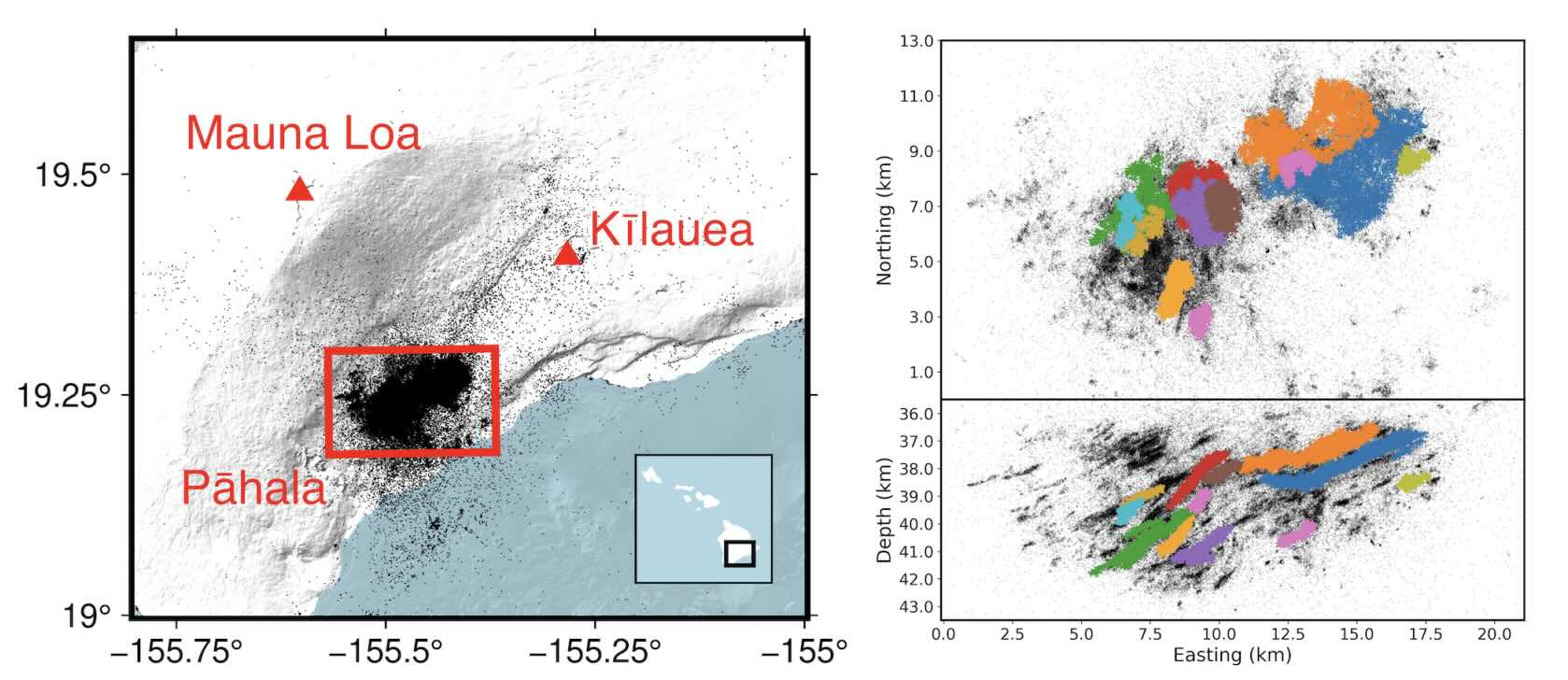
Source Wilding & Ross 2024 https://core.ac.uk/download/pdf/599168379.pdf
Some double-couple earthquakes show compression along an axis that is oriented towards the summit of Mauna Loa. This orientation is determined by the slope from Mauna Loa and is not unexpected, given the size of that mountain! The lithosphere deforms under its massive weight: this deformation is seen in the stress field of the Pahala swarm.

Source Wilding & Ross 2024 https://core.ac.uk/download/pdf/599168379.pdf
The tremor and long period earthquakes occured mainly at a depth below 40 km, in the lower sills. Since 2021 they have also been seen in the higher sills. This is an indication that the sills are growing with new magma injection from below, with the higher sills gaining sufficient magma to now show the gurgling.
At the current time, the smaller events (around M 2) in the western group occur at a uniform depth between 30 and 35 km, while those in the eastern group are marginally shallower, at 29 to 34 km. This is consistent with the angle of the sills, although they are a bit less deep than the mapped sills. The larger earthquakes, M3 or up, occur a bit deeper at 38 km, within the sills region.
Connections
But if Pahala is receiving an influx of deep magma, where will this eventually end up? Pahala has no volcano of itself – it sits on a gap in the market but lacks an outlet. So where does it go? One way to find out is to see which of the three equidistant volcanoes is responding most to the Pahala influx. The activity started with a deep intrusion in 2015. What happened afterwards?
Mauna Loa was first out of the block. In fact it started to inflate already in early 2014, a full year before Pahala took off. The inflation and seismicity at Mauna Loa would continue for 8 years, accelerating in 2019: it eventually lead to the December 2022 eruption.
Source: Lyn et al. 2024 https://www.nature.com/articles/s41467-024-52881-7
Kilauea also got into the game, but with a later start. The inflation at the summit increased suddenly in April 2015, following a two month period with increased earthquakes. In April, there were overflows in the caldera which covered about a quarter of the caldera floor: it could be considered as a hesitant summit eruption. This coincided with a notable but temporary increase in gas content of the magma. The activity continued with ups and downs until the 2018 rift eruption. This summit activity started 1 month before the Pahala’s intrusion.
The third volcano, Lo’ihi, wanted its part too but waited longer. Seismicity here increased only in 2017.
The pattern re-occured in 2019 when Pahala started its main phase of activity. Mauna Loa, Kilauea and Lo’ihi all showed increased inflation and/or seismicity at this time. For Kilauea, this coincided with the rebound from the 2018 eruption, so there were some internal causes for its behaviour.
The fact that Mauna Loa’s inflation started a year before the Pahala swarm argues against Pahala being the feed for Mauna Loa. Mauna Loa has its own deep magma source, and has no need for magma from Pahala. A swarm of deep earthquakes at 40 km depth ocurred in 1983, before the 1984 Mauna Loa eruption. Very recently, a deep Mauna Loa swarm occurred in the second half of 2023, during the recovery phase of the 2022 eruption.
Similarly, the early start at Kilauea indicates that the Kilauea surge was not directly fed from Pahala. Only Lo’ihi may have a case for a connection to Pahala. But the fact that all showed increased activity around the same time does suggest a deeper connection.
On the other hand, the 2003-2007 deep magma surge which affected both Kilauea and Mauna Loa by-passed Pahala. In the 2015-2017 Kilauea surge, increasing 3He concentrations showed that new magma had arrived from the mantle, but this time Pahala did respond. The magma pathways were different between 2003-2007 and 2015-2017. Magma does different things at different times.
Interacting volcanoes
Mauna Loa and Kilauea have different lava compositions, indicating that the magma sources are not identical. Both have separate deep vertical conduits. But they do seem to respond to each other. As is often noticed, Mauna Loa’s sleepy time when it had a near-40-year quiescence (after previously having an eruption frequency of once per 4 years) coincided with Kilauea’s stable eruption where its incoming magma was directly channeled towards Pu’u’O’o. Did Kilaulea monopolise the magma? But they do have magma surges at similar times so the monopoly is not perfect.
Whether Lo’ihi takes part in these surges is something we don’t really know yet. Lo’ihi is twice as far away so it likely more independent. But what kind connection could cause shared magma pulses without shared magma?
One suggestion is that stress in one volcano directly affects the neighbour. However, this stress transfer doesn’t seem to be strong enough to have this effect. Instead, the pressure connection would need to be at considerable depth. This suggests pore pressure as an option, in a deep layer where magma is kept in the gaps in the rock. This mechanism might work in the lithosphere.
The underlying idea is that the deep mantle plume has created a layer where magma is incorporated in rock. This layer is at the bottom of the lithosphere, perhaps 60 km depth, and underlies all of Hawai’i’s most active volcanoes. It leaks magma upward in three locations, through three different conduits, one underneath each of the active volcanoes. If one volcano erupts, this will reduce the pressure at the bottom of its conduit. The reduced pressure will diffuse through the deep layer: the time scale for pore pressure diffusion between Kilauea and Mauna Loa is around 6 months. The diffusion time to Lo’ihi is much longer, at 2 years (it scales as distance squared).
It works the other way around as well: if a volcano has a blockage, and magma collects but cannot move on, it increases pore pressure below and over time, this enhanced pressure affects the nearest neighours. This is one possible way that the three volcanoes might affect each other.
The Pahala feeder

Source: Burgess & Roman 2021 https://agupubs.onlinelibrary.wiley.com/doi/10.1029/2020GL091096
How does this work with Pahala? It is the fourth one, the odd one out: a magma collector without a volcano. Pahala is not the feeder for other volcanoes: all have their own deeper pathway. But Pahala is equidistant between the other three. So one may speculate that magma in the deep layer below this point is in balance, with all three volcanoes pulling and pushing at it equally strong. So the magma underneath Pahala can’t decide which way to move. Instead it is free to percolate upward.
There was always some magma here doing that, making use of the balance of power. It created a sill at a depth of 35 km. But in 2014, in response to a magma surge into this liquid zone at 60 km depth, which none of the three volcanoes could handle by themselves, more magma started to move up here. It reached the 40-45 km zone in 2015.
Continuing the speculation, after the end of the 2018 Leilani eruption, Kilauea for the first time in nearly 40 years had no exit for its magma. The other two volcanoes also were not erupting. The lack of outlet meant that pore pressure increased again in the mantle zone. And magma now came up in force underneath Pahala.
The Pahala sill began to grow and thicken especially between 30 and 35 km depth. Faults in the surrounding lithosphere started to activate and seismicity increased dramatically. The faults separated the activity into the two groups, one underneath Pahala and one further east. This changed only when Mauna Loa began to erupt in late 2022. When this emptying of Mauna Loa had worked its way through the system, activity at Pahala decreased again, albeit still at levels far above that of pre-2018.
The large M5 quake would have been due the lithosphere flexing in response to the added weight of the sill – larger events at this depth underneath Hawai’i are normally due to this flexing.
Future
What will the sill do? The chances of a new volcano developing at Pahala are slim to non-existent, because the pressure from the slope and rifts of Mauna Loa keeps the upper pathway shut. One day Mauna Loa will go dormant and begin to sink, and at that time this region may have a chance to spring to life. For now, the magma seems stuck. The patchwork of faults may allow some magma to move sideways and join the conduits of Kilauea and/or Mauna Loa but this would relatively minor. As any sill, left alone it will over time cool and solidify. It may obtain new magma when the time is right and the surrounding volcanoes shut down for a few years. But being so deep (and getting buried deeper by the flows from Mauna Loa), it may not do anything else.
Remember those layers of lava flows? They are not just punctuated by dikes moving up in the world. The layers are also pushed apart by new sills. Hawai’i really is a patchwork of the old and the new. Dig deep and young and old rocks are intertwined. I like to think of it as conservatives and changists, free marketeers and socialists, republicans and democrats, liberals and nimbys, somehow having to live close together in their separate places. Hawai’i seems a metaphor for our world.
Pahala is sitting at a unique juncture. It feels the effects of three neighbouring volcanoes, each of which can pressurise or de-pressurise it within 6 months. When the three are in balance, Pahala may steal the magma, or at least a little of it. And so the Pahala sill complex helps to build Hawai’i, from deep below. When the time is right.
Albert, November 2024


“To volcano watchers, Pahala was known mainly for the 15-meter deep ‘Pahala ash’, a layer left by Mauna Loa on a very bad day.”
The Pahala ash is from Kilauea, not Mauna Loa. There surprisingly isnt a lot of evidence of major explosive eruptions in the last glacial from Mauna Loa, but there is for Mauna Kea. And 1 meter of Kilauea ash at Hilo in the LGM…
https://www.usgs.gov/news/volcano-watch-kilauea-explosive-eruptions#:~:text=The%20Pahala%20Ash%20formed%20from,exposed%20in%20the%20Hilina%20Pali.
This is the last 5 years of the Kilauea part of the swarm too. Also the rest of the volcano but that us shallower mostly. At least this part of the complex has gotten more active up to present. There isnt any public map for the rest of the swarm graphed like this though.
I wonder if the gap between the quakes is actually magma, like a highlighted magma chamber. Or if not it could show one forming. I think if it gets big enough it will escape through Kilauea regardless, intruding the fault zones and being guided that way by topography. The silent zone between is probably just already hot and lubricated after 70 years. 2018 draining out Kilauea I think did have a big part in this, major decompression. Mauna Loa went quiet while the 2018 eruption happened.
Gap referring to the gap between parts of the Pahala complex, not the gap in quake depths on the graph above, to be clear 🙂
That article was from 1995. This is from 2009:
https://www.usgs.gov/observatories/hvo/news/volcano-watch-one-mans-soil-another-mans-ash-especially-around-pahala
“More recent work further constrains Pahala Ash to ash deposits along the northeast rift zone of Mauna Loa, northeast Kīlauea, and those found south and southwest of Kīlauea’s summit, including the eastern flank of Mauna Loa. The bulk of this ash is presumed to be from Kīlauea, although Mauna Loa cannot be excluded as a source.”
They said it was presumed to be from Kīlauea in that one.
“Ash deposits are the result of explosive volcanic eruptions. Recently, geologists determined that the ash deposits of Kohala, Waimea, Hamakua and North Hilo were derived from Kohala and Mauna Kea volcanoes. These ashes are chemically distinct from ashes produced by Kīlauea and Mauna Loa.”
I guess they changed their minds on the Pahala ash being from Kīlauea (although not ruling it out). I tried to find some papers on the chemical composition of the ash but seems to be very mysterious. So I don’t think Albert is wrong in the assumption it came from Mauna Loa since its heritage is quite mysterious as it is confusing. Until then, it can only be assumed.
Im surprised they cant immediately tell with chemical analysis, it should be no different than with lava. The distribution also doesnt really make much sense for a Mauna Loa source but is exactly where ash from Kilauea goes today. Maybe some is from Mauna Loa but it is more likely to be majority Kilauea.
The 1995 article already talks about Mauna Kea. There is still ash from Kilauea near Hilo too, it is younger. The stuff up in the highlands was known to be different to the ash on the south coast but the name was used broadly, in recent decades Pahala ash is only the south coast ash.
Pahala Ash has been a catch-all for young Hawaii ash so it does include a number of sources. The Pahala Ash in the northern part of the island comes from usual Mauna Kea eruptions which always have a voluminous tephra side dish.
Pahala Ash also extends across the southern flank of Hawaii but is thickest on the south flank of Kilauea, in the Hilina Pali area, where I seem to remember there are exposures of over 20 meters thick. The Pahala Ash likely includes multiple explosive eruptions of Kilauea of poorly understood timing, but Mauna Loa could have also contributed part of the ash. My understanding is that the deposits are mostly altered and reworked lithic ash, gas-driven explosions that blew old lava to bits, and could very well include eruptions that blew through Mauna Loa cover in the Kaoiki Pali area, there is no fresh magma that is very suitable for chemical analysis. Most likely they represent many bigger versions of the 1790 eruption of Kilauea, perhaps associated with collapses that formed the Kaoiki Pali scarp. The best way to learn more would be to drill a core somewhere between the summit of Kilauea and the Kaoiki Scarp, or between the summit and Kulanaokuaiki Pali to get proximal, maybe caldera-filling exposures of Pahala Ash and other explosive eruptions of Kilauea.
I should have read up more carefully. The paper I read associated it with Mauna Loa deposits but did not say the ash came from there too. It had occurred to me that the location was unusual for Mauna Loa, but at 40,000 years old, you cannot assume that the volcanoes were acting like they do now. I have added this note to the post. Thanks for the feedback!
1 meter of ash at Hilo, would be a probable VEI 6. So whatever the source Hawaii is clearly capable of more than just lava shields.
There is much speculation on Mauna Loa being glaciated in the LGM but there seems to be no such questions for Kilauea. It must have had a crater lake and been prone to really huge scale eruptions, a basaltic Taupo. That Eldgja sized lava flow in the deep sea is just the final step, there must have been many such eruptions. Maybe Mauna Loa was even nearly inactive, before resurging in the Holocene. That resurgence might be the actual effect glaciation had on the long mountain, a deep sleep.
Good article on that one. That makes me think of another volcanic feature fairly rarely talked about that the Pahala sill might give a clue.
http://www.soest.hawaii.edu/GG/FACULTY/tshea/pdfs/pamphletPWW.pdf
The Pu’u Wa’awa’a eruption from 110,000 years ago on the flanks of Hualālai. Most of its massive trachytic lava flow is buried by younger flows from either Hualālai or Mauna Loa (mostly Hualālai) and it seems this one was quite explosive, producing pyroclastic flows and large amounts of ash. Matter of fact it is one of the largest eruptions known in Hawaii (~3.5 km³ in volume). It is also the only place where large quantities of obsidian can be found on the Big Island.
The odd thing I am always interested is that it is outside Hualālai’s usual rift activity and also that it was highly explosive and evolved for Hualālai in its more active stage (also Kīlauea may or may not have breached the sea yet). I wonder if, by some chance, it had its own chamber, albeit much smaller, that formed from a similar structure as the Pahala swarm via a leak and evolved until this eruption.
https://www.researchgate.net/publication/314160489_Dynamics_of_an_unusual_cone-building_trachyte_eruption_at_Pu'u_Wa'awa'a_Hualalai_volcano_Hawai'i – eruption dynamics
https://www.researchgate.net/publication/257155067_A_chronometric_tool_for_Hawaiian_archaeology_The_hydration_dating_of_Pu'u_Wa'awa'a_trachytic_glass – chemical composition of the eruption
Nice article. I do agree that Pahala is probably best seen as its own intrusive phenomenon, related to, but not directly feeding the volcanoes around. The most positively related to the Pahala unrest I think has been Loihi given the six powerful swarms in 2020-2022, coincident with peak Pahala activity. Kilauea was actually rather quiet during peak Pahala activity.
Earthquakes > M 2.5 in the Pahala region since 1970 should be reliable since there was quite a seismograph network already, capable of locating small earthquakes. Making the 2019-ongoing Pahala swarm an unprecedented event in terms of the frequency of deep earthquakes since at least 1970.
To erupt or not to erupt, that is the question.
Pahala brings to mind the proposed ‘Loa’ and ‘Kea’ tracks whereby Pahala would be the next in the western branch, followed by Loihi. https://www.sci.news/othersciences/geophysics/mystery-hawaiian-volcanoes-04838.html
Found this interesting:
Geologists think that the mantle plume has undergone a degree of “vertical rebound” and the double-track volcanism of the Hawaiian hot spot will eventually return to single-track volcanism. (From the Nat Geo article on the subject)
There is the hohonu paramount but it seems a little far to be the next ‘Kea’
Seamount*
I doubt that those twin tracks are a correct description of what is going on. There aren’t two distinct hot spots. But having an average distance of 30-40 km between volcanoes, if the width of the track is 2.5 times the typical separation (i.e. the 100 km assumed size of the plume), this gives almost automatically the appearance of two tracks.
Its based on trace element ratios, also that the Loa volcanoes on average are a bit higher MgO too. But that could just be mantle composition locally too. Theres no particular average size increase of Loa volcanoes compared to Kea volcanoes, actually most Kea volcanoes are huge, including what Kilauea is becoming. Mauna Loa is rather big compared to the older Loa chain.
It is notable though that the plume productivity has increased after the two compositions become clear. So there might be increased melting and heat overall, along with the above. But such surges did happen before (Puhahonu) without Loa chemistry so its kind of hard to say.
Really just the fact Kilauea and Mauna Loa interact so much kind of mames ut hard to fundamentally separate them.
Does anyone think there is any correlation between the productivity of Loa versus Kea is related to the movement of the mantle plume relative to a fixed set of coordinates.? Of all the fully grown volcanoes younger than Koʻolau, it seems to me that the volume of the Kea trend increased from West Molokai to Haleakalā as the hot spot moved east. The Loa trend did the inverse decreasing in size from Oahu to tiny Māhukona during this time. When the hot spot began moving south again, the size of the Loa trend increased from Hualalai to Mauna Loa. During this same time, the volume of the Kea trend began to decrease from Kohala to Mauna Kea. Is it plausible that movement of the mantle plume relative to a fixed spot determines whether a volcano samples more of the Kea or the Loa trend and thus determines which trend is dominate at the time? Thanks for your input…
You are thinking off the hot spot as a spot. It isn’t: it is a large disk (plume head) 100 km across. It breaks through the lithosphere in some places. Once a weakness is found, this will monopolize the magma for some distance around – 40 km, to be precise, based on the distances between Hawai’i volcanoes. The disk moves slowly (or rather, the lithosphere and crust move the other way) uniformly, not in sudden jumps. The productivity of a volcano depends on many things, but mainly on how far off centre a volcano is. So Kea is nearing the end while Mauna Loa is still in a good (very good) place. How long the productivity last also depends on how close to the edge of the disk the volcano is: the closer to the edge, the shorter its life span. Note that volcanoes can affect a large area around them through the rifts: these can extend well beyond the hot disk
Kohala is actually at least as big as Mauna Loa, just presently buried by Mauna Kea above water. I have seen somewhere that the same is true for Hualalai and Mauna Loa. The original centers of Kohala and Hualalai are not their present summits, although Hualalai is still pretty active so has built a new shield anyway.
Only Mauna Kea seems to be actually relatively low volume, but exactly how much of its edifice is actually Kohala, and how much is genuine, its hard to tell, same for how much of it has been buried by Mauna Loa in the saddle area. But regardless of total volume the eruptions on Mauna Kea are usually big, actually sometimes very big, and are much more strombolian than its neighbors.
Kilauea is also comparitively small, but that is to be expected for a teenager. Its ERZ is the second longest of all the Hawaiian volcanoes, and rift zone length tends to trend with absolute size pretty well.
Kilauea is probably going to be larger than Mauna Loa, and may well bury a significant part of it or even nearly completely. As crazy as that sounds today it would be the same as happened to Hualalai and Kohala, and maybe also Kahoolawe and Mahukona (if that one is actually distinct).
I think Kohala’s ERZ is longer than Kilauea’s. And East Molokai’s is about the same length as Kilauea’s.
Apart from Haleakala, which of course has the longest rift zone, and probably represents the “peak” of the Loa-Kea duality, given that its contemporaneous sibling, Lanai, had the most extreme isotopic Loa chemistry magma (Koolau managed only briefly to erupt that magma, but Lanai is entirely made of it).
Haleakala is the “best” Kea volcano, with an ultra-long 160 km East Rift Zone, and the longest post-shield stage, 1 million years struggling to defy the hotspot progression and still erupting basanite regularly. Lanai is the “best” Loa, with an endmember Loa isotopic chemistry, short rifts, and dying suddenly while erupting the most tholeiitic, most shield-stage-like lavas ever, and having a massive 10 km-wide caldera at its summit.
Kahoolawe was a good Loa volcano too, that approached the Loa isotopic extreme and lacked a postshield. It was probably contemporaneous with Haleakala’s late shield and the initial long-rift stage of Kohala.
Instead, Hawaii is more of a disaster. A gap in the volcanic chain. A volcano that didn’t even manage a shield stage (Mahukona). Then Hualalai who has a Kea-like post-shield. And then Mauna Loa who wanted to play Kea with its long rift zone. Since the construction of Kilauea things have probably gone back into the proper duality though.
Yes I hadnt measured it directly, Kohala is probably a bit longer. I guess maybe Kilauea is normal for a Kea volcano then, which still means it will grow into a monster just perhaps not THE biggest one 🙂
There is still a reasonable chance it gets at least as big as Mauna Loa. At least it will almost certainly be more extensive, though maybe not more voluminous in a significant way.
Kama’ehuakanaloa might end up like Mahukona, I do wonder if Mahukona actually was small because Haleakala was really big, and so was Kohala. Hualalai somewhat redeemed it by growing big and Mauna Kea underperformed and got a piggyback from Kohala. Mauna Loa obviously is enormous, but seems to have reached or passed its peak, its not getting bigger faster than it sinks, except at its summit and the southwest coast, which is the old Alika scar. At Hilo it only rarely has the volume to get there and only in lava flood events, not shield building.
Kilauea now is growing fast, just not up or at its summit, which might be because it is young and favors the ERZ. Kama’ehuakanaloa MIGHT be getting starved, because I have read somewhere that it and Kilauea are closer in age than either is to Mauna Loa. That being said, I wouldnt be surprised if it is more active than we are aware of and that its deep position is because Kilauea hasnt grown south very much to help out. Either that or the volcanoes grow very rapidly at some point not entirely related to exact age, and it is about to take off.
A paper I read postulated that the highest-partial-melting part of the plume sent magma to Kilauea, not only because of the higher volume of magma but of CO2. Mauna Loa’s supply consisted of lower-partial-melting, and practically no CO2 (comparatively).
I just imagined that the deep parts of the island are permeable to CO2 so it just escapes out the first available exit, which is Kilauea. So that Kilauea basically also gets Mauna Loas CO2 output. But that doesnt really make sense in hindsight or out loud.
CO2 is also a proxy for supply rate, Kilauea has very high supply and Mauna Loa has low supply. Im not aware of an i crease in CO2 immediately after 2022 so maybe that is evidence of magma deeper in the volcano moving up instead of actual rapid resupply, explaining why it didnt last.
Kilauea eruptions that last beyond the initial fissure and arent drowned tend to have tall fountains too, Mauna Loa erupts nore lava for the same fountain height so they are probably driven by gravity more. But there are some exceptions, like in 1940 and 1949 with nearly 300 meter fountains in Mokuaweoweo. I suspect CO2 at Mauna Loa was higher back then but I dont know. And Kilauea still often does big fountains from flank vents that have less CO2 too. And the voluminous ash that Mauna Loa mostly lacks, Kilauea might just be more volatile anyway as you say.
Mauna Loa used to erupt once per 4 years. Now it is once per 40 years. It was obviously a very different beast before 1950.
As to the ‘Loa’ and ‘Kea’ tracks, as I say in the post, I don’t think that exists. There is one tracks that pops up volcanoes (and rift zones) in different locations, and how large they grow depends on the local environment (competing volcanoes) and whether they start growing early or late in the passage of the hot spot. If Pahala develops, one may expect it to stay smallish because it is late and has a big competitor. Mauna Kea is huge (!) but never had large rift zones, presumably because of competition by the well-developed Kohala.
The old sea floor may also affect the volcanoes that grow on them. At the moment, Hawaii is passing a region of old submarine cones which is mainly on the western side. The oceanic crust may therefore be a bit different on the east and western side. That might affect isotopic compositions of the local lava.
It only erupted every 4 years on averave between 1850 and 1950, before 1843 and 1790 there is actually only 1 confirmed eruptions down on the SWRZ, which HVO seems to weirdly not factor when talking about its average. Assuming a date of 1810 for that eruption (radiocarbon average) then there was a 33 year gap to 1843. And going the other way the youngest lava that is older than 1810 is from around 1700, a massive lava flood on the SWRZ probably creating Mokuaweoweo. There were probably eruptions in Mokuaweoweo in that gap but Mauna Loa was quite weak for probably all of the 18th century, when Kilauea was very active. The recent gap of 38 years is probably not too exceptional, although I think the next eruption will probably be sooner than 2050 still.
I read somewhere it erupted close to Cooks visit. I dont knkw if this is true but say it erupted in 1780. Then there was 30 years to 1810 then 33 years to 1843. Then 4 year average 1843-1950, then 25, 9 and 38 year gaps.
1780 was 244 years ago, 36 eruptions in 244 years is about 7 years apart. But 28 of those were within 100 years, so its actually a combination of 3.5 years when active, and 24 years when not. All very rounded numbers but its basically an order of magnitude drop.
Mauna Kea often did “swarm eruptions” with a dense frequency over a relative short time and a long gap afterwards. Maybe the frequent eruptions of Mauna Loa 1850-1950 were a similar period of swarm eruptions. Are they a sign for the final chapter of Mauna Loa’s shield-stage?
Can we consider Hualalai as a minor Hawaiian volcano with a smaller volcano shield (buried below the post-shield structure) than the central major volcanoes?
Hualalai is actually a big volcano, its just largely buried by Mauna Loa. Before the Alika landslides much of the southwest part of the island might have been Hualalai not Mauna Loa. The former caldera of Hualalai is apparently its saddle with Mauna Loa, but after eing buried and probably deformed the old northwest rift of Hualalai became sat over its deep source and grew into a new shield. Maybe the old summit still stored some magma and that is what evolved into the trachyte of Pu’u Waawaa, just a theory though.
Also for Mauna Kea, its true the eruptions are clustered but ‘frequent’ is maybe not the best description. The last 3 eruptions were a century separated. Same for the two eruptions about 2000 years before that. Im not sure the eruptions are very well dated though but its unlikely they were particularly close.
Mauna Kea is currently in the late post-shield stage, maybe not far away from extinction. Therefore thousands of years without eruptions are typical. For Mauna Kea it is now a relative frequent period if eruptions would happen every 100 years.
During the Hamakua Volcanics (early post-shield stage) Mauna Kea had a supply rate of “about 0.005 km3/yr, which is about 10% of the supply rate estimated during its shield stage”.
During the Laupahoehoe volcanics (since 65,000 years ago) the supply rate was only “about 0.0004 km3/y” = 8% of the Hamakua Volcanics. This shows that Mauna Kea is in a very calm state now. https://www.usgs.gov/volcanoes/mauna-kea/science/geology-and-history-mauna-kea
Thanks for the nice article, Albert, enjoyed it much! Nice fitting of the fresh Wilding & Ross info in it too.
My favorite Hawaiian volcano is Mauna Kea. It has a lot of instruments on it. They all look up though, not down…
I’m a bit of a space tragic. Tomorrow Elon is going to attempt his next launch of his ginormous rocket. And the telescopes of Mauna Kea are awesome!
On topic I am especially interested in Lo’ihi, as it looks like the hot spot is in the process of moving about 30 km to the SE. Watching this happen in real (if very slow) time is fascinating. It would be nice if the USGS would instrument that seamount a lot more than they have.
Mauna Kea shows the future of Mauna Loa when it will shift to post-shield stage. Mauna Kea did bury the whole shield by 400m of post-shield deposits. The early post-shield stage is still very voluminous. It allows the volcano to grow by hundreds of meters. So Mauna Loa hasn’t reached the vertical peak of its life yet.
Thanks for the update on Pahala and the Hawaiian volcano family, Albert!
Is the “Pahala sill” in fact the main mantle plume of Hawaii? Maybe it shows that primitive mantle magma usually don’t rise up to any of the three main volcanoes, but usually it evolves to normal basalt both in the conduits of Kilauea, Mauna Loa, Loihi and in the Pahala Mantle Surge. The plume has a mushroom shaped reservoir below Pahala, where it’s caught, but a bit of diffusion still works like in cell biology. In addition changing pressure of the reservoir interacts with the “pipes” of the three volcanoes.
The three post-shield volcanoes Hualalai, Heleakala and Mauna Kea are probably more independent from the Pahala reservoir.
Many thanks for the informative and interesting article, Albert! Always high quality in Volcanocafe!
Thanks Albert for your response earlier. I have learned so much here at the VC and it has made my visits to Hawaii and Campania all the more enjoyable. I highly respect your opinion on the subject of Kea versus Loa trend. I have read several papers that say small elemental and isotopic variances in the petrology between the volcano tracks since Koʻolau can be explained by whether the volcano samples the northeast side of the plume (Kea) or the southwest part of the plume (Loa). What I meant to indicate in my post above that it seems the Pacific plate has moved relative to the plume over the last 3 million years. First the track(s) moved in a more easterly direction from Oahu before lurching south when Kohala took over from Haleakalā ~1 million years ago. If Pahala is the center of the plume head and considering the current location of Loihi, it seems this trend is continuing towards the south. If we plot a straight line from Koʻolau to Haleakalā, the summit of Kilauea would be way out at the end of the Puna ridge and Mauna Loa would be east of where Kilauea currently is. I guess I am just curious as to what might cause this change a motion this “significant” in my layman’s head. I am sure the answer is always over the long haul, everything steers towards the mean rather a much more sinister reason…
It is very hard to make a plate, even an oceanic plate, change direction. It happens when subductions zones start or fail but that takes a long time. Fast apparent fluctuations in direction are more likely another effect. It can just be ‘noise’, a random component to where the next volcano develops. Imagine a candle with a slowly moving piece of styrofoam above it. The candle will melt it. But you don’t get a long line in the styrofoam, you get a series of separate holes. Every time it melts through, the hot air goes up through the hole and melting elsewhere stops. Once the hole is far enough away, the candle melts a new hole. Replace the candle with a hot disk, and you get a fairly regular pattern of holes (presumably – I have not tried this myself. Fire and styrofoam can be a dangerous combination so this is best done as a gedankenexperiment). If you close off holes randomly at some time, the pattern of holes becomes less regular. That is how I envisage Hawaii.
The second option is that the head of the plume varies and wiggles a bit. That may be faster than the time scale over which the plate changes movement.
Subduction rates will increase or decrease at different parts of the plate, some will be flat slab/sticky, some will be (relatively) smooth. It’s possible a sudden jerk of quicker subduction on one corner of the Pacific Plate caused the ‘bend’ in Hawaii, it is being subducted on 6 (?) boundaries, whilst only really producing new crust in the south east corner.
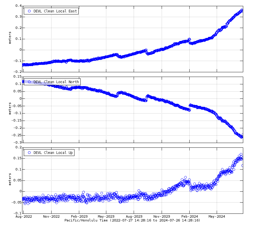
HVO finally got their GPS working again 🙂
The eruption was maybe fairly small but the volume of magma lost from the summit wasnt, nearly as much as back in February on the SWRZ that Hector estimated at 40 million. So maybe about 30 million m3 last time. At 0.2 km3/year supply rate it would take about 2 months to get this, but that also assumes no other changes and we know the ERZ is also filling up now too at a rate that is significant but a bit unknown in absolute volume.
The GPS would indicate about another 2 weeks to break even and then maybe similar to overpressure significantly. So there will probably be another eruption in 2024 but I was a bit ambitious for November 10 🙂
Based on present activity the next eruption will probably be in about the same place as last time.
Yes, it shows that the time of a steep inflation is over since July, when inflation began in middle ERZ. The June SWRZ eruption was perhaps an indicator for the peak of activity in the summit region. We can sum up the recent geological history:
– 2020 to June 2024 period of predominantly summit activity (including the minor SWRZ eruption)
– July/August 2024 beginning of predominantly ERZ activity
DEVL station on upper ERZ shows a peak of deformation when magma passed through from the summit to ERZ in July/August:
 ?fileTS=1732040584
Great article, as a person who doesn’t care about Hawaii volcanoes, I will say that this post is the only time in the last year that I looked twice at a hawaii volcano
OT: Over in Iceland the run up to the next Grindavik eruption seems to be running out of steam. For now that is…
That will put all the estimates for the next eruption off schedule.
That station isn’t above the sill. The stations that are have plateaued though. IMO have also said that stations away from the area have also decreased, so haven’t ruled out other possible causes, such as space weather. They are waiting for the next Insar results before interpreting whether inflation has slowed.
https://en.vedur.is/about-imo/news/volcanic-unrest-grindavik
This is very likely to be caused by external factors such as space weather, or errors in the satellite orbits. Satellite orbits are extrapolated and predicted using Newton’s laws of motion, but there are deviations in the true positions that have to be corrected through actual observation of the satellites. There is a delay of several days before the corrected orbits become available, so the last samples in the GPS series always have a lower accuracy. When the trend is present in stations outside the area of interest it is very likely a common error that’s not related to actual ground movements.
If you look at stations outside of the sill, the trend is actually down, while the ones above the sill are flat. You can see the same trend over all of Iceland, so I’m pretty sure it’s just measurement error. That means that the ones with a downward trend are probably flat and the ones above the sill that look flat are probably still inflating.
There was a similar comment posted a couple of weeks ago showing a similar decrease in a station outside the sill area. That is no longer showing, so has probably been corrected in the way you have said.
Hello Thomas,
Are plots like this corrected afterwards when updated satellite orbits are available? To me that sounds quite complicated for ‘normal GNSS users’ since you then have to know which satellites were used in the calculations of the registered position and know how to correct…..
The original measurements give accurate locations for the receiver with respect to each other. You can measure the difference between two receivers very well, but their actual positions may be uncertain because the location of the satellites may be a bit off. So you only need to correct one location and all others will be correct as well.
Typically, four satellites are used and you always know which ones they were because there are only 5-7 visible at any one time. Which ones are visible at each moment is determined from approximate orbits of the satellite: the receiver has this information, which gets updated once a day or so. The GPS signal then contains the information of the exact position of the satellite at each moment. A receiver then uses signal timing to measure the difference in distance between each of these satellites. (Not the exact distance to each satellite itself: that would require an atomic clock in the receiver.) If updated orbits become available, you only need to calculate the correction to the distance between satellites, apply it to correct your most stable receiver and you are in business. There are other ways to do it, but this would be the easiest.
Thanks Albert for the detailed explanation.
One thing that we should be aware of is that deformation monitoring using GPS requires orders of magnitude better resolution than the GPS in a car or a smartwatch. Everyday GPS users are happy with 1-10m resolution, and for that level of accuracy the deviations in space weather and satellite orbits don’t matter. Ground deformation monitoring records changes of a few mm, which is extremely sensitive to disturbances.
Many disciplines use GPS at very high resolutions. Often claimed as <1mm, in general to <10mm is pretty well guaranteed. Most countries have (often multiple) ground "satellites" that are fixed beacons and because
a) Their position is accurately known.
b) They do not move about.
c) They are generally quite close (<10mile in uk).
d) Reliable atmospheric correction (if any needed).
The accuracies are hugely improved. In the early days a farm would set up its own beacon (~£10,000) for use by the GPS equipped tractors it owned (with satellite use as well of course). Modern house/commercial survey systems use corporate (hired) GPS networks.
Thanks Albert, Tomas and farmeroz for these explications!
Since the beginning of Svartsengi’s activity Keilir and Krysuvik had a negative to neutral deformation. As long as this continues, I’d interpret it as an indicator for continuing flow of magma from Fagradalsfjall’s depth to Svartsengi.
Eruption has started again in Sundhnúkagígum
New eruption just started in Reykjanes!
That was sudden! The earthquake swarm is so tiny…
Agreed, barely even a “swarm” at all. Looks like only a dozen or so reported earthquakes, all low magnitude (unless there’s something wrong with the monitoring systems). Potentially we’ll see a weaker eruption this time?
The swarm was very short indeed, but it was coupled with changes in the boreholes, so for those with access to that data it was clear what was happening.
I was not expecting this. I was expecting at least one more month. The eruption seems to be a bit weaker than the last one, but it’s still impressive.
Weaker compared to the last eruption but probably of similar size to the ones before that really, the March and May eruptions lasted a long time past the fissure stage to prop up the volume, theur fissure stave was much like we see today. Maybe the eruption in August really was the apex of this sequence but its way too early to be confident in that, and there is probably still a significant volume of lava still to be erupted. Whether a few huge eruptions or more numerpus lime now I guess is a mystery.
https://www.youtube.com/live/fCph8qQK3sc?si=kIYmIzrzfK6hNtmt
New eruption at Sundhnúkar… (very unexpected).
https://www.youtube.com/live/Bqudj0x0POA?si=isafhqSYCrx1q64t
Good view so far…
Other cams are down (we need B. Bound now).
https://www.youtube.com/live/ZyndpAPkrQE?si=FxUfsRhdNZQ2t4YL
Looks like fissures is trying to get north again…
Seems to be north of the main cone from the May eruption, so should stay away from Grindavik. There is a big flow to the southwest if the fissure though, which afyer the last year has filled in the low areas and could permit this flow to enter the ocean in a few places. Still very early though and the fissure will surely grow over the next few hours.
https://bsky.app/profile/volcaholic1.bsky.social/post/3lbg5lw25fk2a
https://www.youtube.com/live/LfDiffbPk6Y?si=JbJfU-h-J5mEvoWC
Isak the drone guy will be live in maybe 18 minutes…
https://bsky.app/profile/gongudottir.bsky.social/post/3lb3mngoygk25
FYI, here is the insar map from Nov. 4 – Nov. 16 (likely not relevant now as there’s an ongoing eruption).
Start of the eruption
https://www.youtube.com/live/7qaMYVO6z1g
Squonk!
Oh, I just realized that ‘Irish enthusiast’ above was first, so this eruption has the official name “Irish enthusiast eruption”.
Actually, Jonas reported it one minute earlier. So this is the ‘Jonas episode’
Agreed
Well, that’s a surprise.
IMO already published a map with the new fissure:
and a nice areal picture:
Maybe the strange inflation data signals aren’t due to GPS problems after all?
I still think they are. The timing is just a coincidence. Look at the “baseline” plots at the bottom of the 8h gps page. There you have four plots where different stations away from the sill are subtracted from the Svartsengi data. In those plots, the common error is removed and they still showed inflation all the way up to the eruption.
O.k. I’m much too clueless to argue.
It is kind of a “summit eruption”, contrarily to the August eruption that was a NE rift zone eruption. It is like the Mokuʻāweoweo eruptions of Mauna Loa that don’t escape towards the rift zones.
Well I wuz wrong, since I thought on the inflation data that it’d be a Christmas eruption. Out by more than a month! Oh well predicting the future is hard, said a Dr Bohr once.
Meanwhile more info on a big world-shaking kaboom.
Mysterious Signal Preceded The Most Powerful Eruption of Modern Times (Science Alert, 19 Nov)
It’s not clear from the story what caused the seismic event 15 minutes before kickoff, but there’s some suggestion it might have been a crack which allowed seawater ingress – just enough to clear the throat of the volcano.
Lots of similarities with Krakatau in 1883, where the initial eruptions likewise cleared the throat – allowing a flood of seawater into the conduit, resulting in four titanic explosions one after the other.
Sundhnúkur seems to have an inability to control it’s bowels once more. Fortunately this eruption already looks like it will be over in a couple of days with no damage to property. I suppose it could potentially last a while if inflation is able to restart whilst still erupting.
Shame the lava is not flowing towards Kristján Loftssons facilities
Live lava fissure with visible lava flow: https://www.youtube.com/watch?v=Bqudj0x0POA
The eruption completely surprised me. I expected one in January. Maybe the central part of the fissure system is so open, that it doesn’t need a lot of seismic or inflation signs to do an eruption.
“This eruption is significantly smaller than the last eruption, which began on 22 August. The estimated lava flow rate at present is about 1,300 m³/s, compared to approximately 2,500 m³/s during the August eruption”
The eruption only has half strength of last eruption. Maybe a sign, that it happens on half way towards total recovery from last eruption. Does the volcano in the central part need less pressure to erupt than before?
Perhaps the pathway from sill to dike had still not really cooled/solidified from the last eruption when it was forced open further than it ever had been. Hence it didn’t take much pressure.
Larger gaps between eruptions allow time for the crust to ‘heal’ essentially. It was still pretty hot and ductile.
The fissure is on the same line like the August eruption, but on the SW end near Sylingarfell hill. The first map is from August, the second from today:
Maybe this lava is something that failed to erupt in this SW part of the fissure in August.
The limited inflation and lack of strong seismicity may suggest that this is not ‘new’ magma, but magma left behind by the previous eruption. Over time it may have collected a bit more gas or have solidified a bit, leaving the liquid lighter than before. The last Fagra eruption was like that. This could be a brief eruption, but of course it is also possible it creates a path for deeper accumulated magma to come up.
The eruption has begun on the location, where the August eruption began – before it migrated to the NE. So maybe there was some magma left that failed to erupt in the SW part of the August fissure.
Maybe this was Sundhnukur’s version of Hekla’s pair eruption 1980-1981, when the August 1980 eruption continued in April 1981.
I dont buy the idea any of these werent ‘real’ eruptions, the eruption peaked at the same rate as most of the others just less than in August, but that is likely also because the fissure was half as long not any less productive. Every eruption in this section has had reducing seismicity, it is the center of the fissure and all the dikes start there, it is probablt getting eroded wider every time., in August seismicity was higher because the dike went further but the eruption was quite fast to start too as I recall.
For Fagradalsfjall too there was deflation during eruptions and uplift between them, maybe not as consistently or as fast though. The lava did evolve over the 3 eruptions but there was obviously still a direct feed to the ultimate source, just there was existing magma accumulated.
Its also possible the magma had two sources at the same time, 2021 directly shows it but 2022-23 might have had dominantly source 2, 2021 and the last 3 eruptions at Svartsengi are source 1. Something like that anyway. The 2022-2023 eruptions had more crystals, but the melt was still extremely fluid. 2021 and lava since May 2024 looks like it mostly has no crystals at all in some shots, although that isnt diagnostic.
I think intrusion into the northern part of the Sundhnúkur swarm during the previous intrusion has made it easier to produce dikes. The first dike of the sequence had already spanned the whole southern section, but the previous dike was the first to open a path into the northern section and I think that must be what has changed, causing a smaller premature eruption due to easier conditions to form a dike through the newly established pathway.
https://www.youtube.com/watch?v=DPAaeTUD8fY
Nice view over the eruption lava fields showing all the lava thats been piled up since last november like a layer pancake, if eruptions keeps piling up lava flows like this on this area in comming years, in similar manners like it have done herer before, Svartsengi are going to produce a very odd small, flat type “flood sheild volcano” like a little Hekla that also grew from a fissure system but flatter and far more fluid. Its future morphology and ultimate size will depend on how long the eruptions keeps piling up there and how large each eruption gets. The eruption started with very little earthquakes so the conduit system is fairly open and quite well established by now. Its almost like a little sub – set volcano is forming, but I doubt it will become any anomalously large in the future as past holocene geomorphological structures have not formed this idea in Reykjanes, still this idea coud perhap be analougous to moberg ridges that erupted frequently in Ice Age and piled up on same place maybe
Seems that the lava advanced quite far to the west, creeping onto a parking lot and even destroyed a small building there. No worries, the blue lagoon is well shielded.
In addition to the end of Live from Iceland youtube streams (although the website still has a couple of streams up) I now see this
https://vafri.is/quake/
Hope thinks are okay for Hreinn Beck (Live from Iceland) and many thanks to him and others involved for previous excellent coverage and maybe some day again if possible.
The parking lot and some facilities of Blue Lagoon are going to get an Heimaey-like destiny: https://www.ruv.is/frettir/innlent/2024-11-20-eldgosid-komid-i-hefdbundinn-farveg-428061
The parking lot may be built some meters higher in future. But how many eruptions can the walls of the Blue Lagoon stand, before they collapse?
This photo shows parking lava where otherwise cars would park:
https://myndir.ruv.is/eyJidWNrZXQiOiAicnV2LXByb2QtcnV2aXMtcHVibGljIiwgImtleSI6ICJtZWRpYS9wdWJsaWMvb3JpZ2luYWxfaW1hZ2VzL0RKSV8yMDI0MTEyMTEyNDEzNV8wMDUzX0QuSlBHIiwgImVkaXRzIjogeyJ0b0Zvcm1hdCI6ICJ3ZWJwIiwgIndlYnAiOiB7InF1YWxpdHkiOiA2MH0sICJyZXNpemUiOiB7IndpZHRoIjogIjE2MDAiLCAiZml0IjogImNvdmVyIn19fQ==
https://www.youtube.com/live/rkTxPIEUWGQ?si=k8Btj0YQfUfMvxEA
Webcam for the leading front of lava flow. Seems the parking lots in question are far from other previous lava flows, so this one went farther away…
https://www.youtube.com/live/8bfcTBLvPiM?si=lOW-1ni19dOAUeYp
Better view.
The Blue Lagone?
There are tall wide walls around it, its completely safe from lava flows for
now
The Blue Lagoon itself is free of lava now. But half of the parking lot was flooded with lava within 20 minutes, and the roads are interrupted as well. Traffic access to the Blue Lagoon has become difficult.
Looks like the lava is still trying to get inside (I see red areas at the wall).
on what stream?
https://www.youtube.com/live/8bfcTBLvPiM?si=lOW-1ni19dOAUeYp
IMO has a very nice GIF today in their most recent update. I’ll see if it will insert…
Keilir had an optimum point on November 13th, maybe an indicator for rising pressure towards Sundhnukur. Also the August eruption had a small inflation moment.
brunnur.vedur.is/gps/eldfjoll/reykjanes/KEIC-plate-90d.png
Interesting thought. Do you suppose that the slight deflation was really a leak of magma which would have told us to expect the unexpected eruption? I am torn as to if the GPS readings indicate a slight deflation going on. One more thought, Back in August, the fissure eruption started near or at where the maximum steaming was occurring. I could not help but notice that the fissure was steaming vociferously again, in the minute or two before the magma broke the surface. Maybe setting a laser up to read the occlusion of the water vapor to the beam line might give us a hint as to when the next fissure eruption might occur? (Just a thought)
A thermal infrared camera might have caught the eruption developing a few minutes before it began. The steam responds to heat, and heat is visible in the infrared. Those are expensive beasts though
Albert:
Thanks for the reply. I timed the notification in August, it was only about 90 secs or so advance notice on the steaming. I think perhaps borehole pressure data might be a good solution in this case. I do remember awhile back that we did have steaming from the fissures about 18 hours before the actual new fissure eruption.
I’d assume that magmatic pressure, that leads to an eruption at Sundhnukur, also causes a small inflation at Keilir, until the eruption begins. There is a system of magmatic reservoirs from Keilir (Fagradalsfjall) to Thorbjörn, where rising magmatic pressure probably increases pressure on the solid rock over the whole region.
They already have the borehole data. The changes in the boreholes have consistently shown when the eruptions are about to happen. This time, changes in the boreholes that indicated that the eruption was coming were detected 7 minutes after the start of the quakes, almost 40 minutes before the eruption started.
Regarding the Keilir GPS, I don’t think we should read too much into a couple of noisy samples. Look at all the other GPS stations. They also show similar noise and a downward trend starting from the 13th. Remember that the GPS data is 3-dimensional. The interesting stuff always shows up also in the horizontal components. The up-component is also the one with the worst accuracy.
By boreholes do you mean the ones in the Svartsengi power plant, tiltmeters in boreholes, or something else?
The ones in the power plant. I think when magma goes into the vertical dyke the ground on the sides of the dyke gets compressed, which increases the pressure in the wells. This never happened during the swarm on November 4th.
Tomas:
Your comment that the borehole pressure readings are a reliable way to predict the incoming new fissure eruption is probably right on the money. I wonder how much it would cost to drill and put boreholes all over the place in Iceland? (smile)
https://www.youtube.com/live/U011uA8escE?si=ZRsPYWlXUhEl_E0S
Isak is live now…
https://youtu.be/hG3P49veLQM?si=GifzuGaOwhWuYfFx
Video part of lava flow destroying a powerline indirectly.
RÚV has an absolutely surreal and wonderful drone photo of the carpark. Unfortunately not in a format that will insert though.
Eruption on Reykjanes Peninsula (RÚV live blog, 20 Nov)
https://myndir.ruv.is/eyJidWNrZXQiOiAicnV2LXByb2QtcnV2aXMtcHVibGljIiwgImtleSI6ICJtZWRpYS9wdWJsaWMvb3JpZ2luYWxfaW1hZ2VzL0RKSV8yMDI0MTEyMTEyNDEzNV8wMDUzX0QuSlBHIiwgImVkaXRzIjogeyJ0b0Zvcm1hdCI6ICJ3ZWJwIiwgIndlYnAiOiB7InF1YWxpdHkiOiA2MH0sICJyZXNpemUiOiB7IndpZHRoIjogIjI0MDAiLCAiZml0IjogImluc2lkZSIsICJoZWlnaHQiOiAiMTgwMCJ9fX0=
The lava flow at the parking lot looked like A’a on some photos. The distance to the source has probably cooled and slowed the lava a bit.
I would guess it wasn’t that hot to begin with
This article has two videos with the a’a lava front behind the speakers … also an opportunity to enjoy their language.
https://www.ruv.is/frettir/innlent/2024-11-22-logreglustjori-byst-ekki-vid-auknu-adgengi-428402
They’ve lost 350 parking places to the lava. Next visitors for Blue Lagoon likely have to hike there.
Interesting to see how the lava has advanced between the two videos, and how it is coming at the interviewee during the second video. It couldn’t have lasted much longer!
I disagree, the lava looked like liquid metal flowing down away from the fountains at the start. A’a flows are just the surface texture, the viscosity can still be low inside. It would have cooled down flowing but it started off very hot.
Randall – Thanks for putting that up! RÚV have now changed the photo on that thread to a different one.
Lava continues to go west. They say that the activity at the three vents is stable, but the lava flow has reduced. If the lava flow continues to run west, it is going to reach Eldvörp’s old lava field.
https://myndir.ruv.is/eyJidWNrZXQiOiAicnV2LXByb2QtcnV2aXMtcHVibGljIiwgImtleSI6ICJtZWRpYS9wdWJsaWMvb3JpZ2luYWxfaW1hZ2VzL3ZsY3NuYXAtMjAyNC0xMS0yMS0xOGgwNW00NnMzNTYucG5nIiwgImVkaXRzIjogeyJ0b0Zvcm1hdCI6ICJ3ZWJwIiwgIndlYnAiOiB7InF1YWxpdHkiOiA2MH0sICJyZXNpemUiOiB7IndpZHRoIjogIjE2MDAiLCAiZml0IjogImNvdmVyIn19fQ==
New lava flow map and graphs (Icelandic News, but English article will probably follow soon):
https://www.vedur.is/um-vi/frettir/eldgos-hafid-a-sundhnuksgigarodinni
some pretty InSAR for someone clever to interpret
http://brunnur.vedur.is/pub/vincent/insar/map/
Select:
− COSMO-SkyMed
reykjanes A33-krysuvik 20241120-20241121
Interesting. Looks almost like Thjorburn Hill is a cold lump sitting on magma moving around.
The large area of concentric circles is the deflating sill. Then to the east of it there’s a small butterfly pattern showing the dyke. If you look closely, you see areas of non-coherency that outline the lava flow.
The deformation from the dyke looks much smaller than for previous episodes.
Wasn’t the sill of November 2023 from SW to NE? The Butterfly pattern now looks rather like a NW to SE direction of a graben-like depression below the current eruption location.
On the Japanese Meteorological Agency site, there was an earthquake swarm on the south east section of Towada caldera in Japan yesterday. No other indicators so far such as ground deformation tec.
If a small-moderate intrusion has just started, there might not be any noticeable deformation on the first day. It could just as easily be a hydrothermal or tectonic swarm
In Sumatra the for me until now unkown Dempo Volcano had a Strombolian ash eruption (3700m high). “Historical eruptions have been restricted to small-to-moderate explosive activity that produced ashfall near the volcano.”
https://www.volcanodiscovery.com/dempo.html
Not the volcano for a VEI 4-6 eruption, only VEI 1-2. 1994-2022 all five eruptions were VEI1, something phreatic or strombolian. 2023 a VEI2, and May 2024 another VEI1. VEI1 is 10,000 to 1,000,000 cubic meters. It can fill a soccer arena with 1 to 100 meters with ash.
https://www.youtube.com/live/kJ0YN-ZpIdQ?si=RSn6wBUb-IyRTAYq
Livestream from today, the output is still pretty high, its expanding the flow field near the Blue Lagoon slowly and still keeps an open channel for probably way over 1 km from the vents feeding it. It is something I hhavent seen co sidered, but a relatively smaller opening might permit a sustained flow at a high rate for longer. In August it was extremely high yet still stayed strong for a week with huge fountains. This time, output was half that at peak, but if a similar volume erupts in total then the output of stage 2 could still be significant and stay that way for days or weeks.
I expect as the vents die out and focus to one spot that it too will fountain high like last time. Im not sure that will necessarily change the risk factor but if it does then it probably shows a new character to the eruptions. The first eruptions were only fissures, then one persisted weakly for a long time, then its successor much more strongly. Then, most recently, stage 2 was powerful and as voluminous as the fissure stage. Perhaps this time, stage 2 will be the dominant part.
Chad:
Watching carefully the gas emission from the vent is a fairly reliable indicator of the future activity of that vent. I am not sure that we will seek strong fountains like the previous one, however.
Beautiful view of the eruption, moon, and aurora on the same webcam right now:
Two to three active craters now: https://www.youtube.com/watch?v=kXD4A9uFHcg
My own personal comments –
This unexpected eruption has caught nearly everyone by surprise. I know that we believe in the strength of our scientific methods to explain nature (to explain reality) but in this case we are caught up short. We really know not too much about how nature really operates, certainly not too much about magmatic activity on the Reykjanes Peninsula.
I don’t know what it is about human beings, who seek to be on the pinnacle of knowledge, but I am glad that this unexpected eruption happened, so that all of us are humbled.
Let’s try to move forward but remember that nature is the teacher.
I pretty much disagree.
The eruption was entirely expected; only the likely start date was uncertain, because it can’t be well-predicted ahead of time.
And when the time did come, the signals we *know* indicate an imminent eruption – seismicity accompanied by borehole pressure changes – were seen as expected, and the eruption duly followed quickly, as expected.
The signals in the hour or so before the eruption were as expected – your important word is indeed ‘quickly’. But the preceding pattern was different from the 6 previous episodes – no obvious dike formation (unless it had happened much earlier) and the inflation had been less. Patterns create expectations rather than making predictions. According to expectations, this eruption was coming but came early. So I guess you are both right..
Maybe the dike of August was still there like a subterranean magma lake that only needed enough pressure to erupt again. This would remind to Strombolian eruptions or the period of rythmic activity of Gelingadalir 2021.
Mike:
There were a lot of predictions released using past behavior. In fact I have a 4 spreadsheets of such. Yet, this eruption occurred much sooner than anticipated. I believe we need to remain humble and be willing to be taught by nature, and I trust you will agree.
To be honest, I doubt many here were that surprised since a well known motto is “volcanoes do what they dam*ed well like”. People are generally more surprised when a prediction is remotely right.
Science can very well understand the causal relations that lead to eruptions like this. But they can’t measure all conditions all the time to get a perfect prediction.
The Borehole method has proofed to be an indicator for a coming eruption at Sundhnukur. It was correct statistically, and they/we can explain it by causal relations. But this volcano is in a comfortable area which allows the successfull use this method, that on other volcanoes (f.e. Hekla?) would fail.
I think borehole pressure can be quite reliable for other volcanoes as well.
It has, but tiltmeters are much easier to install and would do the same thing: pick up minute pressure changes or pressure changes that develop very quickly.
The main magma system of Hekla is probably too deep for tiltmeters to work well. Hekla probably does produce all the same signals we see at Svartsengi, or at Kilauea, tension quakes, uplift, microseismicity and tremors. But Kilauea does this 2 km deep, Hekla is nearly 10 times deeper. Maybe no coincidence it also erupts about 10x less often, adding in lower supply too. It just takes a long time to build the pressure to break up to the surface, but it is very fast once initiated due to pressure.
I will though say I doubt the eruptions are as silent as the legend. We have now seen numerous very well documented dike intrusions from magma chambers, they are fast sometimes extremely so, but none are initially silent. Kilauea took HVO by surprise in 2020 with all their kit, Hekla only had one instrument in 2000 and none in 1947. Next eruption I think will be noticeable before.
Volcanoes often are somewhat individual and may have their own prefered method to notice a upcoming eruption. Sometimes it’s seismicity, sometimes inflation, sometimes hydrothermal / thermal behaviour, sometimes a mixture of certain conditions.
https://vafri.is/quake/
Hreinn Beck is going to end his quake site and I’m sad. I refer to it nearly daily, it’s so well laid out and functional, for me as a non-scientist.
Oh well, arrow of time & all that.
Guess it cost much time and money, many, many thanks to Mr. Beck.
Kat, I am looking at new volcano cams right now from “Live from Iceland” Please take a look at http://livefromiceland.is/ I see lots of cameras being set up. Did someone else take over?
Hello, Kat.
As an alternative there is this site: https://skjalftalisa.vedur.is/#/page/map
You probably already know of it. Hope it helps.
Best wishes
Kat, agree with everything you wrote.
The moon has thrown us a real curve ball. Apparently volcanic activity and the formation of granite can occur which we still need to learn about. See https://www.nature.com/articles/s41586-023-06183-5 I am not sure I totally agree that this is a granitic emplacement in the lunar crust, but it is fascinating to find out that our moon is more complex and alive than we realize.
Inflation returns to Kilauea summit
While the Pahala swarm continues, some minor earthquakes have occured below the summit caldera and southern summit area (SDH):
New post is up! Bristol, January 1607. What could possibly go wrong?
https://www.volcanocafe.org/the-1607-bristol-tsunami/