
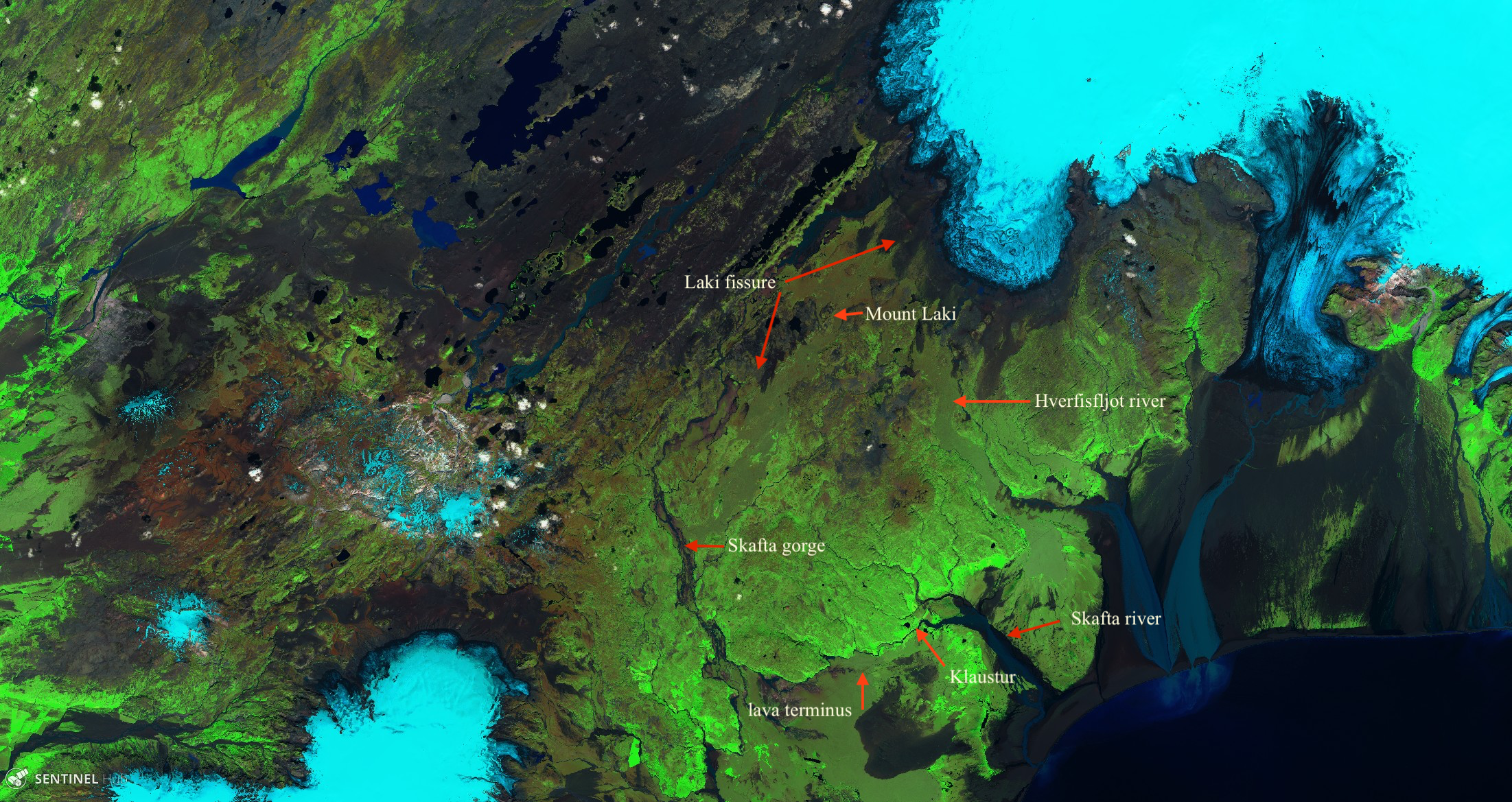
The place where in 1783 the lava approaching Kirkjubaejarklaustur stopped, during the famous fire mass.
Laki was one of the defining events of Iceland’s history. Its impact went well beyond the nation, covering much of the northern hemisphere. It seems amazing that something that caused so much suffering was seen by so few people. This it shares with Eldgja, which was even larger and must have devastated Iceland, but of which no eye witness report remains. There are reasons. The largest disasters leave the local population decimated and local areas uninhabitable, and the historical record is lost. The region in which the eruptions occurred, and which Lurking has named the Dead Zone (because of lack of earthquake activity), was unsuitable for habitation due to previous lava floods. So no one saw the rift opening, and the lava was only seen when it came spilling out from the river canyon, some days later.
The best record we have is from the local priest, mentioned by Carl: Jon Steingrimsson. He was quite a remarkable person, well educated and caring, and his observations have stood the test of time. His diary is much more than a scientific record: it is a personal story of happiness, worry, despair, suffering and survival, in a developing disaster that would claim the life of his wife and leave him destitute and starving and decimated his human flock. It is about being human in a time of the inhumane. But it doesn’t answer the major questions that we would like to answer about the Laki eruption. What made it happen? Where did the magma come from? Could it happen again?
Looking back

Let’s first get the lie of the land. The map shows the main locations in the story of Laki. Klaustur is the place where Jon lived during the events. It is along the river Skafta, which in those days came from a 200-meter deep canyon further west. The canyon has been filled by Laki lava and no longer exists. Nowadays the Skafta is fed by multiple small tributaries. The first lava flows came down the Skafta gorge, after the rift southwest of Mount Laki fissured. Later, the eruption shifted towards the northeast and now the lava flowed through the canyon of the Hverfisfljot river.
Carl has explained the timeline of the Laki eruption. The first explosion happened in the morning of Sunday, 8 June 1783 (Pentecost Sunday), as Jon was getting ready for the church service. The ash turned day to night, but by afternoon the sky had cleared. The ash returned the next day. The Skafta river began to dry up, and by the afternoon had stopped flowing completely. The lava appeared in the lowlands on June 12, having come down the canyon. The following Sunday, some of the local farmers trekked into the highlands, climbing a peak (Kaldbakur, 8km due north of Klaustur – not the mountain of that name in northwest Iceland – still over 10 km from the Laki rift) to get a view of the events. They were the first (and only?) to see the rift in action, reporting twenty fountains of fire. (Following their example, these types of eruptions are now called ‘fires’). The number may well have been exaggerated – how would we know? By mid July, the lava was encroaching on Klaustur, but it stopped on Sunday 20 July, during Jon’s famous fire sermon. The flow ceased because of a combination of reducing lava flow and quenching by heavy rain (and of course the famous sermon of which sadly no transcript survives).
Four day later, the fissures northeast of Mount Laki opened up, with a major explosion on July 29. The new flows came down the Hverfisfljot river. By August 3 this river no longer flowed, and on August 7 lava appeared in the lowland. This was more sedate than the June eruption, but in the end just as devastating. Various eruption episodes continued, each one accompanied by a new lava flow down the river valley. The last of these was late October. After this, there was still fountaining but at rates too low to reach the lowlands. It was stopped by cooling. Lava can flow as long as it is hot enough. When eruption rates get less, the lava flows become thinner and therefore cool faster. Lava tubes can extend the reach by a lot, but for surface flows, the lava reaching less far is a first sign of a tapering off of the eruption. So it was at Laki. The last fire was seen on February 7, 1784.
(In case Jesper is about to ask, the eruption temperature of Laki is estimated at 1140 C.)
Were there any warnings? Was there any sign that it was coming? Here, we only have Jon’s diary. He recalls vivid dreams which he took as a warning of things to come, but of course this carries little scientific weight. Early in the year he noted a blue smoke on the ground, of unknown origin. That probably had nothing to do with Laki. There had been an eruption on Reykjanes which had created a new island (Nyey). It did not last long. The blue smoke may have been small aerosols, blown towards the east from the Reykjanes eruption. Or it may have been a nearby farmer burning something he shouldn’t. Sometime in May, the Skafta river flooded with muddy, bad-smelling water. The cause is guess work: it could have been due to an emptying of a lake that had been caught behind an ice wall, up in the highlands. The bad smell though may be explained as gas escape, signalling encroaching magma. The first obvious indication of trouble came from earthquakes. These started mid-May, and by June became strong enough that people started sleeping outside. (In Iceland!) Knowing what happened during Holuhraun and Leilani, it is not hard to interpret this. A dike was opening up, with magma moving in the rift looking for a weak spot.
Spot the rift

The Laki craters
This was a massive case of rift indigestion. Laki erupted some 15km3 of lava. It is easy to overlook how much that is. The village where I live measures about 4 by 4 km. Laki could have buried our entire community under a kilometer of lava. Who said that mountains couldn’t move? An entire mountain was on the move! Jon’s community was threatened by a molten mountain coming down the rift.
We know which rift system is to blame. The highlands are transected by numerous linear rifts, together forming several rift systems. Each system belongs to a different central volcano. Bardarbunga is most active. It has a well developed rift system, called Veidivotn which runs from Vatnajokul to Torfajokul. It is the cause of most of the rift eruptions in the region. Over the last 9000 years, Bardarbunga produced 12 large rift eruptions. The winner was the massive Thjorsa flood, dated to 8600 years ago, producing 25 km3 of lava.
The second possible culprit is Katla. It is a very different volcano. While Bardarbunga is a typical rift volcano, Katla is an intraplate volcano which does almost all of its eruptions from the caldera. However, it did manage to connect to the spreading rift on one occasion, in 939 AD. What followed was the massive Eldgja eruption. The Eldgja rift runs just southwest of Veidivotn. Eldgja produced typical Katla magma, but at the far end it produced tholeitic lava which clearly came from Vatnajokul. Nowadays we understand this better, because Leilani showed how a rift eruption can push out older magma which had been left behind by an earlier incursion. Eldgja pushed out magma deposited in the same rift but from the other end. It invaded the Bardarbunga rift system.

Veidivotn. Figure from Halldorsson et al. 2008, Chemical Geology, 255, 355
But Laki did not come from either of these. It erupted on the Grimsvotn rift system, an immature and possibly growing system. Grimsvotn much prefers eruption at its caldera or on short rifts a few kilometers either side. However, on occasion it reaches for the sky and goes for a massive flood basalt. There are two large ones known, and two smaller ones: 4,550BC Laki (Botnahraun: this caused the birth of Mount Laki); 3,550BC Thordharhyrna (Bergvatnsarhraun); 1,950BC Raudholar and Brunuholar; 1,783AD Skaftáhraun (Laki) (names and dates from Carl). (Raudholar has also been associated with Thordarhyrna.) This is the most southerly of the rift systems, and on the map one can see that it has fewer rifts: it is less active.
Sourcing the magma
During the weeks of intensifying earthquakes, the mountain of magma was working its way through the rift. But from where? The obvious answer would be that Laki was fed by the Grimsvotn magma chamber. After all, this is where a third of all Icelandic eruptions happen and Laki was part of the Grimsvotn rift system. Both Veidivotn and Eldgja were clearly fuelled by magma from their central volcano. The erupted lava would nicely fit inside the caldera. In addition, the Eldgja eruption caused a major change in the topography of Katla. Before Eldgja, its jokulhaups would go in all directions – no direction was safe. Afterwards, they only ever went southeast. The mountain had changed.
This of course was also true for Holuhraun and for Leilani: in both cases we can relate the erupted volume with the hole left in the caldera. But not for Laki. It has three problems. First, the caldera of Grimsvotn is too small. We also believe that this crater changed little during the eruption: the crater lake of Grimsvotn causes regular jokulhaups, and these did not change from before to after the eruption. Second, it magma chamber is too shallow. It is only around 3-4 kilometers deep, and this makes the route to the surface too easy. Sufficient pressure to force open the rift would already have opened the summit conduit. Thirdly, its magma chamber is too small. It may be up to 10 km3 of which only a small fraction will erupt at any one time. It can’t hide tens of cubic kilometers of eruptible magma.
But if not Grimsvotn, where did the magma come from? We know it wasn’t the dead zone itself. The reason is that magma and heated rock are less dense than cold rock. Thus, they expand and push up the land. And the dead zone is not particularly high. The big bulge is Vatnajokul, and there is little doubt this is where most magma is created and moves towards the surface. The topography of the land tells you so.
There are in fact two models for feeding these rift eruptions. One model assumes that the entire rift is fed from the mantle below, with magma moving up vertically along the entire rift. The second model assumes a central reservoir, with the magma moving sideways along the rift. The second model has become the main one, since it fits all recent rift eruptions, in Iceland, Hawai’i and Ethiopia.

Sentinel infrared image of the Laki fissure
If you are still in doubt, look at the Laki rift. The same physics that limits how far lava can flow also works for magma. As the flow rates decrease, magma can travel less far. The early eruptions of Laki were the most voluminous. Later ones were smaller. So you would expect that the eruption site would tend to move closer to the origin. And this is exactly what happened. The eruption moved from southwest to northeast, straight as an arrow – pointing at Grismsvotn. Talk about a smoking gun!
So the answer lies in the direction of Grimsvotn, but not in its shallow magma chamber. We need to look deeper. For Grimsvotn is fed through dike intrusions from deeper chambers. We know from the composition of the Grimsvotn ejecta that its magma spends time at a depth of 10 to 20 kilometers, where undergoes a bit of crystallization. This should not be viewed as a deep magma chamber. It is more likely a thick region of partly melted material, with pockets, sills, and dikes though which magma slowly percolates up, perhaps collecting in a lens of fully melted material at the top of the region.

Daniel Kelley and Michael Barton, 2008, Journal of Petrology, 49, 465-492
Could this region have fed Laki? The similarity between Laki and Grimsvotn lava suggests it may be. For instance, they have identical enrichment in 18O, different from what is found in the mantle. However, there are also differences, such as a slightly different U and Th concentrations. The 18O may also have been affected by water finding its way into the magma.
The composition of Laki lava is remarkably uniform. That suggests it came from a single, well mixed magma chamber, not an extended mush as found underneath Grimsvotn. However, this chamber may have been located within or near the mush region. The depth of the Laki chamber has been estimated at anywhere between 15 km and 7 km. The composition suggests that the magma resided in this chamber for a maximum of 1000 years, possibly much less.
It makes sense that Laki was fed by such a reservoir. Dikes are normally angled upward; if it starts too shallow the dike is likely to break the surface nearby – as in fact Grimsvotn itself tends to do. A dike breaking out from a reservoir more than 7 kilometers deep is more likely to reach as far as the end of the Laki rift, 30 km from Grimsvotn. Such a reservoir, close to but distinct from the Grimsvotn feeding region, would also explain the subtle differences in composition and the fact that Grimsvotn itself was not damaged by the Laki eruption. The mid-crust Laki reservoir cannot itself be a direct feed for the shallow Grimsvotn magma (this is ruled out by the composition) but it can have the same source.
A fire in the making
Icelandic magma reservoir can erupt a maximum of 10% of their volume before the pressure drop ends the eruption. Thus, to feed the Laki eruption requires a magma chamber of at least 150 km3. As magma had been stored for up to 1000 years, one may assume that this chamber has existed throughout that time. But that is not quite true. The magma appears to have been collected at different times at different temperatures and pressures, at different depths and locations. Perhaps only in the last 50 or hundred years or so before the eruption did it coalesce into a single chamber. This is indicated by a variety of crystals found in the erupted lava. Was the coalescing triggered by some event, perhaps a rifting event or a major earthquake? That is not known. There was a major fire eruption in Krafla, from 1724 to 1727, called the Myvatn fires: perhaps there was on-going rifting.
I mentioned that Laki lava was remarkably uniform. That was not entirely true. The lava contains a fraction of crystals, with properties that differ from that of the lava. It is evidence for a crystal mush that was picked up by the Laki magma. The fraction of the mush changed during the eruption: it became larger as the eruption progressed. There is a small group of olivine crystals that acquired an outer rim deposited from the Laki magma. This layer grew over a period of 1 to 2 weeks. These crystals were apparently picked up while the magma was traveling to or through the rift. The time agrees with the duration of the earthquakes preceding the first explosion. But other crystals must have spend months in the Laki magma. This, it is possible that in the months before the eruption, magma was already on the move.
Laki had around 10 separate eruption episodes. Some overlapped but there were also quiescent periods in between that lasted longer than the 1 to 2 weeks that magma took to travel the rift. Thus, it appears that each episode was driven by a separate magma pulse. That may explain another peculiarity. Why are Laki and Eldgja so much larger than other Icelandic fires? Holuhraun produced a bit over 1 km3 and this appears to be typical. But each individual episode of Laki also produced such an amount. Perhaps this is the normal eruptive capacity of an Icelandic magma chamber feeding a rift: once this much has been erupted, the pressure has dropped and the eruption closes. Laki was different because the magma chamber was re-supplied by fresh magma during the eruption, and these pulses re-opened the rift. But the pressure did drop over time, and later magma pulses did not reach as far along the rift.
Grimsvotn itself erupted a number of times during Laki. But these eruptions were during the latter phases of Laki. As the magma pressure in the rift dropped, Grimsvotn came back to life. That may just have been the magma eruption rate. The magma pressure has to keep the dike open. As the pressure reduces, the dike closes a bit and therefore less magma gets through. Now magma is becoming backed up, waiting for its turn and looking for another exit. And the shallow magma chamber underneath Grimsvotn was ready and waiting to act as the valve.
The earth didn’t shake
The main sign of the impending catastrophe was seismic. That was how Jon knew something was coming. There were several weeks of intense earthquakes as the dike forced its way through the crust. But what about the years prior to Laki? Did the accumulating magma body not produce earthquakes? We know that Grimsvotn announces its intentions in this way, with slowly increasing earthquake activity over several years. Bardarbunga also had some earthquake swarms in the decade before Holuhraun. But these events are small, in fact surprisingly small in view of how much magma accumulates. To put it in context: Bardarbunga had months of M5 quakes as the caldera collapsed by 60 meters. Why did the preceding inflation not generate the same quakes? And why was the observed inflation before the eruption so much smaller than the collapse afterwards? It is as if much more magma was extracted than had been inserted. Was that also the case for Laki? Wouldn’t the intrusion of a magma body the size of Laki have caused significant earthquakes long before hell broke loose?
The lack of strong precursor quakes tells us two things: accumulation takes time, and it happens below the brittle-ductile transition, i.e. at depths where the crust is hot enough to become a bit elastic. New models for Bardarbunga’s Holuhraun eruption were published this week which suggest that the behaviour can be explained by a buoyant magma body within a visco-elastic crust. Visco-elastic means that if you deform something, it slowly creeps back to its original shape. You all know materials like that. Honey is the liquid equivalent, and memory foam is a solid form. How quickly it returns to its original shape depends on the ratio between the elasticity of the material and the viscosity. For the hotter mid-crust of Iceland, it is something like 25 to 50 years. The idea is that if you drip-feed magma over this time, everything adjusts fine without stress – no large earthquakes. And because the pressure hardly increases, it can spend a long time very close to failure before breaking. This allows much more magma to accumulate.
In fact this may explain another aspect of Icelandic fire eruptions: why they can erupt so much. How can 50 centimeters of inflation leads to 50 meters of collapse? Shouldn’t the eruption stop when the 50 centimeters has been lost, as this clearly was a stable situation? A visco-elastic magma chamber can do this. As magma is expelled, the chamber does not contract quickly – it takes its time. This leaves the chamber underpressured, and makes it possible for buoyant magma from below to replace the erupted magma. (It also allows the caldera above to begin collapse.) It is a neat model which can explain the typical size of Icelandic eruptions (although I haven’t seen those numbers plugged in to the models), as well as the multiple eruption pulses of Laki and Eldgja. It requires a large magma chamber at or below 10 km depth. But scarily, it also predicts that there are few signs of the coming storm. And there is no way to tell whether it will be a one-trick pony like Holuhraun, Leilani, or Mayotte, or a long-term disaster like Laki – or Pu’u’O’o.
Visco-elastic crust can not cope with a magma influx that is too fast. It works as long as the chamber inflates slowly, over decades to centuries (or millennia). If the magma moves in too quickly (for the size of the magma chamber), the behaviour becomes more brittle-like and pressure rises: the magma will now be pushed out. This may be why Grimsvotn and Katla have so many summit eruptions but so few fires: their magma supply rates are too high. (Katla, being an intraplate volcano, will have less ductile crust. Its supply limit will be lower than for Grimsvotn.) Bardarbunga is a bit more sedate, and this allows deeper magma to slowly accumulate for the next fire. If this is correct, it would indicate that the magma reservoir that fed Laki is indeed separate from the one that feeds Grimsvotn. But Laki and Grimsvotn have similar lava production rates (in km3 per year). To reconcile this, we would need to pose a nearby reservoir which is much larger than the one feeding Grimsvotn, but with a similar magma input rate. The race is on to find this reservoir.
Fire alarm
The story of Laki is still being uncovered. Research is now mainly focussing on two things: quantifying the impact of Laki on the environment, and studying how those crystals in the Laki lava can trace what happened underground. But the final question is whether this could happen again. Laki devastated Iceland and affected every nation around the North Atlantic. A re-occurrence would have predictable but unforeseen consequences: life stock suffering fluorine poisoning, acid rain causing injuries, people having to stay indoors for months on end. Any warning would help. (Yes, I know about how much good that did for the current epidemic.) What would those warnings be? It appears that we could see something brewing, by inflation and small seismic swarms, followed by unmissable shaking in the weeks leading up to the eruption, perhaps with increasing gas emissions. But these might not tell you the size of what was to come.
Jon took his warnings from his dreams. Science can’t do that – we need measureables. We are getting to the stage where we can detect signals of coming eruptions – even if many of these fail to progress to actual eruptions. But to distinguish the coming storms from the hurricanes, that may still be beyond us.
Albert, May 2020

The Skafta river


Excellent article Albert! Did not realize how many questions remain regarding the parent Laki magma source. I do have one question though regarding lava temperature (since it’s often mentioned in VC articles/comments):
Is the “temperature” a measure of the lava as it erupts, or is it a measure of temperature that the magma was subjected to at depth? I ask this because it seems logical that adiabatic cooling of lava as it get’s extruded through a flow-restricting orifice (conduit or fissure) would be measured at a lower temperature than magma lower down? Conversely, I would expect that extra heating would take place within the orifice itself as magma is “squeezed” as it flows through a narrowing channel? So, we could have three distinctly different temps to consider….magma temp at depth, peak magma temp as it gets forced through a restriction, and magma temp at the point of the eruption?
Just curious.
Liquids, being incompressible, don’t change volume much, and it is when gases are squeezed into smaller volumes or allowed to expand into larger ones that these large temperature changes occur. So, I would not expect temperature changes in the magma from this type of cause.
Thanks for reminding, but it’s my understanding that erupting lava or magma at depth is not pure liquid…rather a “froth” of sorts with oodles of trapped gas(s), which could allow for magmatic compression/decompression…i.e. adiabatic effects?
I’m pretty sure I’m still out to lunch and missing something elementary, but inquiring minds rotting on the vine need to know these things! LoL. 🙂
Different temperatures are used. Above I quoted the eruption temperature, which is the temperature at which the lava reaches the surface. Then there is the temperature of the magma chamber, which is the temperature which determines the composition of the magma. Temperatures increase further down due to higher pressure, as you mention, so often this temperature will be quoted for atmospheric pressure, i.e. they correct for the pressure term: it is the temperature the magma would have if brought to the surface instantaneously, with adiabatic cooling.
Thank you Albert for the clarification(s)!
A Gem. Thanks much!
Thanks Albert!
This is a true masterpiece
Question
How open conduited is Bardarbungas magma system? The upper part is blocked by the plug
Bardarbunga seems to have a rather large supply
How does Bardarbunga
look like in its depths?
I know that Almost no volcano except from Etna and Kilauea haves well modelled magma systems.
The idea is that the conduit is well blocked, and the only way up is through the caldera ring fault. The dike that caused holuhraun may have initially gone up via the caldera ring fault, before heading out away from the caldera.
I meant
How does the deep magma system look like under Bardarbunga?
Is it open and largely molten?
with large magma chambers?
Or is it mushy melt zone with many sills and dykes and no real structure?
Holuhraun was very hot indeed
1188 C
So hot that human gets incenirated on the spot
If you fell into Baugur
Because Holuhraun was so hot
It must have come very deeply and risen very fast.
Albert is Holuhraun the hottest Icelandic lava flow ever seen since settlement?
Holuhraun was well … toasty!
We know that Holuhraun lava would have taken several days to flow down the dike from the magma chamber. As it didn’t cool much, the dike must have been wide (cooling rate depends on the dike width). Later in the eruption the flow was less and the dike would have been cooling. I expect that lava wasn’t as hot later in the eruption.
Albert Holuhraun was very hot among documented eruptions.
Is Holuhraun the hottest Icelandic eruption ever caught on camera.
Almost 1200 C Holuhraun was!
How many icelandic rift eruptions have been caught on a high resolution thermal camera? I think the answer might be one.
My compliments on a most excellent article. You have laid out what we know, what’s been disproven and what we surmise so very, very well. Now, we just need a ‘middling’ eruption to crown what looks set to become a long, hard Atlantic hurricane season. Unlike Eyjafjallajokull {Gesundheit !!} an eruption this year won’t greatly interfere with air-travel…
Great article. I’m very interested in the physical sciences after a career as an engineer. Your (and others) articles have brought me a much better understanding on how this stuff works, but now my mind’s model is going to have to change more than usual. However, I’m having trouble reconciling this with the “gravity” model you previously offered on the events in the “dead zone”. Obviously there are a lot of contributions to the energy required to cause these enormous events, but does this visco-elastic concept change your thoughts on gravity causation?
To some degree, yes. The buoyancy pressure is more important than I had given it credit for. In the model, this is the main driver for the first week or so of the eruption. After that, caldera collapse begins and the gravity term is added in the equations. In the last phases, I expect that the gravity term becomes the main driver. Gravity is very important in which direction the magma takes, as it will always go in the direction of least stress. That is along the rift, towards lower surfaces. So much of the gravity survives, but there is more going on.
Just a thank you from me.
Superb read and thank you!
Three lines of evidence converge to convince me this model is correct rather than Carl’s.
1. The site of the fissure terminus, about midway between Vatnajokull and Myrdarsjokull, is what one expects from a propagating dyke fed at one end: the other stops going horizontally when it reaches a place where the overlying terrain is uphill in every direction, and goes straight up. Under Carl’s model, the fissure row having one end there and the other near (or under) Vatnajokull is pure coincidence — why wasn’t it instead from 1/4 of the way from Myrdarsjokull to Vatnajokull to 3/4, or 1/3 to 5/6, or etc. instead? Albert’s model predicts it to be right about where it was.
2. The concentration of activity toward the Vatnajokull end of the fissure row as the event waned. The end it should concentrate toward is where the distance from the source is least. Under Albert’s model, that’s the northeast end. Under Carl’s model it’s the southwest, since the low point in the terrain there is where the distance from the MOHO would be least, and in the foothills of Vatnajokull it would be higher (especially as the MOHO itself should be an upside-down mirror of the surface terrain, with the crust floating like icebergs on the mantle).
3. The chemistry being (modulo the small amount of stale tholeite erupted near Vatnajokull) near-uniform. I’d expect that along a 40 km line that’s more or less radially outward from the hotspot plume head’s center there’d be some sort of gradient of chemistry and even temperature in the mantle materials. Under Carl’s model, the erupted lava would have reflected such a gradient, but it did not do so, pointing to a more compact source for the erupted material. Albert’s model has such a more compact source.
That last might also help with locating that source. The chemistry of the lava likely tells us something about distance from the center of the plume head, and that would narrow it down to an annular region under Vatnajokull. The Skaftar Fires fissure row line will extend to intersect that annulus in just two locations, and the farther of those from the Dead Zone will have the terrain go up first, then down when traveling toward the Dead Zone along that line. If the chamber were there, the dike would have gone northeast into the plain where Holuhraun happened instead, and therefore the chamber is at the southwestern of those two intersections.
Not explained yet: the apparently bimodal distribution of fires eruption sizes in Iceland. We get 0.something to 1.5 cubic km events like the Krafla fires and both Holuhraun eruptions, and we get 10+ cubic km Dead Zone events (the smallest I’m aware of being a Veidivotn event with about 7.5 km^3 lava plus a bunch of tephra, probably summing to near 10). Where are the 3 and 4 and 6 km^3 fires eruptions? This intermediate size range seems not to occur. It isn’t chamber size or structure: Bardarbunga alone produces such a bimodal distribution. It could be gravity: the altitude of the Dead Zone plain is lower than that of the Holuhraun plain (and Krafla area) by a fair bit. So the size might be mainly about the eruption location and not the source chamber. That, of course, fits Albert’s model; on the other hand the bimodal distribution is also consistent with Carl’s, where it would arise instead because two qualitatively different eruption mechanisms are operating. Finding eruptions of an intermediate size into an area of an intermediate altitude would, however, cast further doubt on Carl’s while being well supported by Albert’s. A gradient within the Dead Zone, of larger eruptions farther east where one is closer to the sea, doesn’t distinguish the two: for gravity-driven, the lower altitude predicts larger eruptions; for Carl’s model, having the MOHO closer to hand would make it easier to have larger eruptions.
What we should be looking for to clinch it, and to instrument for better early warning of a future eruption from that source, is a 25 km^3 caldera of young vintage somewhere along the extension beneath Vatnajokull of the Skaftar fissure row’s line, perhaps between Grimsvotn and Thordarhyrna.
That’s almost like looking for Planet X (or rather 9). Maybe a dumb question but isn’t there any sort of mapping (possible) of what lies underneath Vatnajökull (glacier)? Something like Sonar perhaps?
Yes, radar maps of the bedrock exist but they have not been published, apart from a few low resolution pictures. Greenland and Antarctica are better mapped than Vatnajokull! Here is a (radar) map of the surface of the glacier. The big caldera at the top is Bardarbunga. The circle indicates the typical size of the structure we would be looking for. Here I am assuming that there was no caldera collapse but a larger area subsided smoothly by something like 100 meters. It would be hard to see this in bedrock because of the volcanoes. You could also imaging something further north. After all, half the caldera wall of Grimsvotn is kind of missing. That would be the hole between Grimsvotn and Greip.
Aftershocks of the 5-15-20 M6.5 near Tonopah Nv continues at a strong rate. The aftershocks are showing a clustering pattern, with 4 zones clearly delineated. Here’s the shocks for today only and for the last 7 days.
I wonder how high the total seismic moment will wind up after all is said and done?
https://www.flickr.com/photos/188530792@N07/?
I was hoping to see you commented after today’s aftershock. Quite a transition for the desert since I’ve lived in CA. Enjoying your comments.
from USGS:

I should have pointed out the location of these events with respect to a VEI-7.

There was a 6.1 on the plate boundary near Cabo San Lucas today.
Excellent article from a tremendously good series. Thank you very much! As ever your hard work in writing these articles is very much appreciated.
A great summation, and a problem poser. I think from somewhere within the combined thoughts of Albert and Carl, with help from Fluid Dynamics above post there is a PhD in this…any takers?
Take care, now.
Klyuchevskoy has been quite active lately. A current pic:

An M5.3 aftershock earlier today was the largest so far. As mentioned, the current pattern has been showing clustering, and this new shock is the farthest north (so far). I don’t think there will be much more of a northward progress in the shocks, as it’s already starting to enter into the seismic shadow of the M 7.2 1932 Cedar Mountain quake that relieved stress across over a dozen faults in the Walker Lane.
https://earthquake.usgs.gov/earthquakes/map/#%7B%22autoUpdate%22%3A%5B%22autoUpdate%22%5D%2C%22basemap%22%3A%22street%22%2C%22feed%22%3A%227day_m25%22%2C%22listFormat%22%3A%22default%22%2C%22mapposition%22%3A%5B%5B37.950153709955984%2C-118.37081909179686%5D%2C%5B38.42293213401053%2C-117.49191284179688%5D%5D%2C%22overlays%22%3A%5B%22plates%22%2C%22faults%22%5D%2C%22restrictListToMap%22%3A%5B%22restrictListToMap%22%5D%2C%22search%22%3Anull%2C%22sort%22%3A%22newest%22%2C%22timezone%22%3A%22utc%22%2C%22viewModes%22%3A%5B%22settings%22%2C%22list%22%2C%22map%22%5D%2C%22event%22%3A%22nn00730721%22%7D
Originally published February 26, 2011 at 10:00 pm Updated February 28, 2011
Subj: Cascadia region.
https://www.seattletimes.com/seattle-news/dangerous-ground-hard-lessons-learned-since-the-2001-nisqually-quake/
“By examining sediment cores for evidence of underwater landslides, Goldfinger pushed the record back to include 22 megaquakes over the past 10,000 years.”
Early 2011 some in Oregon seem to have had premonitions !
On March 11th in Japan, the unpreparedness of the North West coast of the USA to the risks of a major earthquake became glaring.
January 2011 : https://www.oregonlive.com/opinion/2011/01/oregon_should_make_itself_resi.html
Intentions in 2013 (large PDF). https://www.oregon.gov/oem/Documents/Oregon_Resilience_Plan_Final.pdf
Not to mention Portland, Oregon sits smack in the middle of the Boring Lava field, with some of the monogenetic centers right in city limits.
Maybe Portland should be twinned with Auckland
and Naples.
One of my favorite town names is Boring, Oregon. It exists.
https://www.youtube.com/watch?v=ePPuGXsRWas
French SS Normandie must be the most beautyful ocean liner ever built.
The perfection of streamlining and shape…
Art Deco legend
Back in the days… when ships really looked like ships!
Todays crusie ships in 2020 are so insanely ugly looking
floating shoebox skyscrapers without taste today…
Todays crusie ships are beyond ugly.
All modern crusie ships are an enemy of taste and beauty!
The jet age killed the ocean liner 🙁
Every single… modern crusie ship…including Oasis Of The Seas..
is now an enemy of art and taste.
They just get more and more blocky and boxy…as time goes
They dont look like ships anymore.
We must move quickly against this…
If this way is not destroyed… shipbuilding taste will come to an end…
Once more.. the Classic Ocean Liner shall rule the seas
Please Jesper, can you find another platform for your observations on cruise ships?
Whoops this conversation was meant for the The VC bar
My vision is very bad now so hard to see
Yup This is not the bar
Anyone knows that how fast the Laki lava flows was near the vents?
Extremely fast…
Likley flowing at almost 100 kilometers an hour in the well formed channels when the fountains been going for a while.
Jon Steingrimsson described it as a true river of fire that flowed very quickly
100 Kilometers per hour at the flow front!???
NO at the channels near the vents
The flow fronts where much slower.. advancing at walking speed or a little faster
Still a 7 meter high Aa wall of lava comming at walking speed.. is terryfying!
I read that tree workers near Skafta had to abandon their works.. to escape the lava flow
Why its called the dead zone?
Zombies?
Hi Brother… “Dead Zone”
That name is what Geo Lurking callsthe earthquake silent Icelandic
South East Rift Zone.
The crust is hot and mushy there.. so not alot of earthquakes
Laki is right in da zone… read the article
I knows you are pretty new in VC too
The Maximum size for dead zone eruptions are so far unknown. There is loots of huge long hydroclastic ridges there from massive subglacial Ice Age Fissure events.
I wants to know the volume of these!
But we have had Laki and Eldgja in human historical times
18+15 km3 = 33 km3
Then there are other prehistoric ones from earlier in holocene. The maximum size for Icelandic flood basalts is probaly over 30 km3 of lava at once.
Generaly only 10% of an intrusion erupts
Holuhrauns intrusion was then 10 km3
Eldgjas intrusion was Freaking 180km3 then
Is these numbers correct Albert?
The magma chambers are large. The intrusion that triggers the eruption can be small. Bardarbunga does a holuhraun every 150 years or so (and sometimes something bigger). That tell you that the magma chamber grows at something like 0.01 km3/yr.
https://m.youtube.com/watch?v=0IrI_KjvBgY
Great documentary on Katla volcano.
New one too
But sadely I cannot understand Icelandic
I dont understand Icelandic either..
Still they speak good English
I wants to move there ! work in Reykjavik and visit volcanoes on free time. Moving to Iceland is my lifegoal
The often quoted number for the Holuhraun dyke is 0.7 km³
0.01 km3/yr for Bardarbunga?
Thats similar to reuinions magma source
Thats still larger than most other volcanoes
But for the whole Vatnajökull its probaly almost 1 km3 of magma
every year thats put in?
Icelands melt rates are enromous many km3 every decade
Kilauea is around 0,2 km3 every year.
Icelandic magma chambers are well known for being huge.
The magma melting accumulation zone under Vatnajökull is
many 100 s of km3 perhaps over a 1000 km3
Most of the magma goes into passive rifting
the rest goes to the central volcanoes in Vatnajökull and its surroundings
Katla and Bardarbungas must have had an enromous crustal magma chambers knowing the size of its calderas
Big early Holocene events.
How large is the sulfur output from Katla?
It haves a very high CO2 emission but what about the sulfur?
Is there any chance for Icelands Northen Rift Zone( Askja Arera ) to develop something like Erta Ale?
After all its almost same geological setup
Yes brother that is possible… is a possibility
Theistareykjarbunga, thats north of Krafla is an Icelandic version of
Erta Ale almost. It too was formed during long slow… long lived tube feed eruptions. Theistareykjarbunga eruption lasted well over 100 years possible, with eruptive rates similar to little faster than Puu Oo.
Theistareykjarbungalikley had extensive lava lake activity when it weas erupting. It also haves pit craters
Albert souch an eruptuion today in Iceland … woud be a huge enromous opportunity for tourism… with decades lifelong slow lava eruptions.
In my lifetime, all icelandic eruptions been fast and brutal… but nothing constant
A large very slow shield episode that last longer than a mans life
Woud be Ideal for Icelandic Tourism
lava is always acessible and can be hiked to.
But I agree that fast events like Laki and Holuhraun are more impressive.
But they are so fast… that the mantle cannot supply magma fast enough.
Thats why they drain themselves dry… the fast Icelandic lava eruptions.
They dont last very long.
Theistareykjarbunga In Northen Iceland
Likley erupted at near base supply rates
So like Puu Oo it coud have lasted forever… until something disturbed the setup
Albert
What kind of eruption do you want next time in Iceland?
I knows that we all wants Thjorsahraun 2.0
But thats not a likley scenario in our lifeftime.
MY opinion
Holuhraun is very fun as Laki too was an impressive sight.
But I think tourism wise a long lived slow shield episode
woud be the most fun for the Icelanders.
Souch an eruptuion today in Iceland, woud be a good opportunity for tourism. With decades lifelong slow lava eruptions.
Where in Iceland coud another Theistareykjarbunga or Trölladygnja happen?
Albert where will the next Theistareykjarbunga form?
Where in Iceland is souch a shield building most likley to happen next?
Reykjavik. There hasn’t been a major eruption from the west volcanic zone for 5000 years so it is time.
(just kidding – my guess is as good as anyone’s. Who would have expected Mayotte?)
Nice recent documentary on the growing glacier on Mount St. Helens and also the growing dome.
Recommend this video. sometimes Geology happens faster than we realize. Working out of Aurora, Oregon I used to take people on tours of the volcano. Over the edge of the rim, and fairly (within legal limits.) of course, they don’t do that now. this was in the period 1984-87. I was never really comfortable doing that, as back in April of 1980 I flew a group of USGS people a little too close for comfort.
as the mountain was waking up..
The M6.5 Tonopah earthquake has resulted in some very interesting post-event observations.
Here’s a few tidbits taken from a report from Dr. Ross Stein, et al at Temblor, that provides some interesting data and commentary. https://temblor.net/earthquake-insights/implications-of-the-tonopah-magnitude-6-5-earthquake-for-worldwide-seismic-hazard-assessment-10966/
Despite the hypocenter being at shallow depth, no discernable/continuous surface rupture has been found, therefore the amount of slip is equally undetermined. What cracks that have been found are scattered and discontinuous, suggesting they resulted from shaking and not crustal movement. Further validation of minimal surface expression is confirmed by an interferogram of surface deformation which shows much less change than what would normally be expected from a shallow quake of this size.
“Strike-slip earthquakes around magnitude-6.5, like the one near Tonopah, typically produce at least 8 inches (20 centimeters) of slip at the surface, along a length of at least 9 miles (15 kilometers; Wells and Coppersmith, 1994). The July 4, 2019 magnitude-6.4 Ridgecrest quake produced up to 3.3 feet (1 meter) of slip over a length of 12.4 miles (20 kilometers). The Tonopah quake produced none. So, this event — which occurred in a similar tectonic environment — is an outlier”.
This part of Nevada is one of the best-mapped regions on earth, yet no surface expression has been found to suggest an earthquake hazard (of this size) existed. This in turn implies that seismic hazard forecasting models that rely heavily on “known” faults are not adequately factoring in accumulated strain at depth which in turn may be a bigger contributor to potential seismic hazards (especially in the Basin and Range, but applicable worldwide) than by using known faults alone as indicators/predictors of past and future activity.
Since the main shock and aftershocks involved both normal and strike-slip faulting mechanisms, a Coulomb analysis of both types reveal that stress has been increased across four lobes, SW, NE, NW and SE of the hypocenter, with reduced stress zones between each lobe. Note, the recent M5.3 aftershock (largest so far) was centered within the NE lobe of increased stress.
Interesting to note that as of today (5/24), the # of aftershocks has dropped significantly since the M5.2 aftershock that occurred two days ago near the southern tip of the 1932 Cedar Mountain stress shadow….hence I would expect that the M5.2 aftershock will be the furthest north for this particular event. However, there hasn’t been commensurate activity to the SW, which should have experienced a similar amount of additional stress. So far, nada to speak of…but certainly an area to watch for another significant aftershock in the future.
Lastly, there have been some small quakes detected between the Tonopah quake zone and another recent aftershock zone just east of Mono Lake. There is a notable seismic gap between the two events, but there are no historical records of significant quakes nor visible faults that would suggest any physical linkage exists between the two zones…other than the minor aftershocks just mentioned. Should there be some hidden faulting (which the report clearly mentions as a possibility for the entire Basin and Range), a new slip within the gap could produce another 6-ish magnitude quake.
Shallow quake; large size; no surface rupture?
Is it possible the initial quake had a horizontal, or near-horizontal, fault plane? Do they have a published beachball for this one? It would be blank if the whole surface moved uniformly in only one direction, I suppose.
Meanwhile, do we need to worry about Jesper? First all his apparent glee about the potential destruction from flood basalts, and now if I’m not too terribly mistaken he’s paraphrasing Emperor Palpatine in Revenge of the Sith … well, even if he is a budding supervillain perhaps we can buy him off with a present, like say a shiny new volcano lair. 🙂
Moment tensor for the M6.5 mainshock. Slightly oblique right-lateral strike slip was the predominant motion.
Curiouser and curiouser! That should definitely have made a surface rupture. Is it possible they are wrong about the depth?
Test of Flickr to upload images.
https://flic.kr/p/2j42XdW
Rats. Still just a link.
Can someone please let me know how to post a picture? After tinypic went down, I’ve been clueless?
I think flickr will never work different from your example. To get the picture to display, it needs to be a link to the photo itself, not to a webpage that contains the photo (the reason is that that page can contain all kinds of other code – wordpress allows the link but not actively). And it needs to be on a site that wordpress trusts. Again I don’t think we have any control over it. I don’t know what options that are these days!
Imgur is probably the easiest option. Flickr can be used, but you need to go click the “download” arrow in the lower right corner “View all sizes”, and then right click on the image and copy the image url.
Thanks guys! I’ll keep trying. You’ll know when I succeed.
Test2 https://www.flickr.com/photos/188530792@N07/49935183482/in/dateposted-public/
Craig,
I use flicker here is my process.
Select photo saved on my hard drive (not sure if it will work in private folders, I put in in my public space) which is the Cloud icon in upper right (I upload JPG and PNG file types). It will let you modify the file at this point, if finished then click on the upload button on the upper right. Now the photo is in Flicker.
The photo should show in your public area(or private), double click on the file to open it.
Now in the bottom right of the window click on the download icon, I choose all sizes.
You can now choose the size that you want to use, or you can right click on the photo at this point and “copy image link” ,, places the link in your clipboard
Then return to Volcano Cafe and paste. It should show a file name (i think this one is 49933965318_f81c33a4bb_o.png) when you paste it. Once your post your comment the picture should show.
Mac
Thanks Mac! It worked!
You are welcome!
Mac
test 3

Yipee! Got Flickr to work.
Thank you very much.
A welcome graphic.
Thank You!
There was a small quake on the San Andreas fault itself, south of San Fransisco, today. It is just beyond the part that caused the Loma Prieta quake. No worries – this part is more creepy and less shaky than elsewhere on the San Andreas.
When I was young we would camp out at the Pinnacles… remnants of an old volcanic province. The other half of them were on the other side of the San Andreas, and so are far to the South.
We have written about that here! https://www.volcanocafe.org/volcano-at-fault-neenach-and-the-art-of-moving-mountains/
Informative article. We used to go down there from San Jose in the heat of summer and chill out in the caves.
Pinnacles is a nice park. Yes, old volcanic area and they have California condors there.
For the met-freaks amongst us (Albert?)…this pic of a LP supercell was taken recently from my backporch south of Redding, Calif. in the northern Sacramento Valley. Pretty rare, but not unheard of…as we are in a convergence zone that can on occassion produce some exceptionally powerfull storms

Wow, quite the corkscrew shape.
Yes. It’s caused by a rotating (and powerful) updraft. One of the signatures of a tornado-capable storm…although in this case all we saw was a brief elevated funnel.
That’s gorgeous, Craig. I’m a Met nerd too. Looks like you’ll have another shot at thunderstorms this weekend as the front passes through Oregon. Great pic of a classic barperpole updraft. A friend of mine who lives in Red Bluff got a great shot of a similar storm last year
New post is up. The child of Billy Mitchell
https://www.volcanocafe.org/bagana-child-volcano/
Many thanks for this piece and the Bagana article, Albert. I have been obsessed with the Laki saga since I first came to the Cafe. I hope to see Iceland in this life. It’s hard to really get the scale from pictures and maps. The descriptions and explanations help bridge the gap.