Super-eruptions are rare. That is probably a good thing, even for Tallis. Too many things can go wrong for us in a supereruption. If you need a reminder, a super-eruption is often defined as a VEI-8, erupting more than 1000 km3 of ‘stuff’, leaving a crater 20 kilometers or more in diameter. Hector has written about volcanoes with super-potential: ten volcanoes with super-eruption potential part i/ and part ii . An overview of volcanoes that have done these things in the past can be found in Power of the past part i and part ii. Enjoy!

Relation between erupted volume and caldera area. Plot produced by Geolurking.
These are not eruptions like we have seen in modern times. The two largest eruptions of the past 2000 years are Tambora in 1815, and Taupo around 200 AD. They ejected around 150 km3, decent VEI-7’s but nowhere near the magic VEI-8 border. The most recent VEI-8 is the Oruanui eruption (1170 km3), which happened 26,500 years ago. It left a caldera 35 km across. If you now wonder where on Earth this was, think New Zealand. It was almost the same place as the Taupo eruption of 1800 years ago. All of the North Island was covered in tephra between 20 cm and 2 meters deep, and nearer the eruption as much as 200 meters. New Zealand seems such a nice country – but of all the nations in the world, it is the most likely to attack us with an oversized eruption. (No worries, we have our man on location tasked with keeping an ear to the ground.)
How would a super-eruption affect us? First to know is that they are not always like the run-of-the-mill VEI-7 events. They are big but not necessarily as explosive as smaller eruptions. The Oruanui eruption was a series of perphaps 10 events which together accounted for the ejecta. Eruption rates must have been very large, but you can have too much of a good thing: too much tephra suppresses the rising convection that carries dust to the stratosphere: the weight of the tephra is too much and the rising column collapses, instead forming pyroclastic flows. Even the enormity of the Toba eruption deposited most of its ash in the region between Indonesia and India, and left eastern Indonesia much less affected. Fountains will still reached enormous, almost Jesperian, heights, of course.
The local area, say within a few hundred kilometers, would be uninhabitable for a long time. Sulphur would kill all life in an even wider region. There could be other toxins: fluorine and mercury poissoning are possible over large areas. And we would expect a massive impact on climate, with global cooling far in excess of the year-without-summer of Tambora. (But not in the US, which apparently has decided that it is immune to climate.) No, a VEI-8 would not be fun. It is a good thing they are so rare.
Toba, the largest eruption of the past million year, happened 73,700 years ago (give or take 600 years). It has been blamed for the ice age and for a genetic bottleneck in humanity. However, in both cases the evidence is insufficient for a conviction. The ice age was quite happily progressing for 100,000 years, and clearly did not need Toba. (Similarly, the suggestion that the Laacher See caused the Younger Dryas did not survive when improved dating showed the innocence of the eruption.) And people re-occupied India very quickly after Toba, while if the world population had really been down to a few thousand, repopulation would have taken far longer. We know that large eruptions can cause years of cooling, but predictions of much longer-lasting cooling may be mainly due to bad press. On the other hand, the link between extreme warming and flood basalts is well established. These effusive eruptions dwarf even a VEI-8 and emit large amounts of CO2. Hence the silent spring of the Permian mass extinction.
A recent paper has studied the climate impact of a lesser known, relatively recent super-eruption. It was located not in distant New Zealand, but around the corner, in Guatemala.
The Los Chocoyos eruption

Lake Atitlan is one of the (many) volcanic wonders of Guatemala. The lake is elongated, measuring 18 by 8 km. It is flanked by three volcanoes, of which the namesake Volcan Atitlan is the youngest and most active: it formed in the holocene. Toliman is older and dormant, and San Pedro is extinct. Remove these volcanoes, and a more circular lake appears. This lake formed in a major eruption. It is called the Los Chocoyos eruption (literally ‘ the Parakeets’). The eruption ejected 1200 km3, a solid VEI-8 and almost 10 times larger than any eruption of the past 2000 years. At a time when every 3rd full Moon is called a ‘supermoon’, we can surely call this a super-eruption.
So when did it happen? There were smaller eruptions from the location 54,000 and 130,000 years ago: the ejecta of the large event are sandwiched in between. That still leaves a lot of time. The eruption has been dated to 84,000 years ago but with significant uncertainties. In 2021, a paper appeared which used radioactive dating of zircon crystals in the ejecta. These give the date when the magma crystalized, presumably close to the time of the eruption. They date the eruption to 75,000 years ago. That is within a few thousand years of Toba! Ift would mean that the world had two super-eruptions in the amount of time in which we have had ‘just’ two Tambora-sized events. It was a different world in those days.
Is there corroborating evidence? That brings us to the recent paper on this eruption, by Helen Innes et al., which discusses the dating and the worldwide climate impacts.
Much of the 1200 km3 of tephra ended up in the ocean. This is not surprising for an eruption in the narrow Central American isthmus. Such sediment is not easy to date. However, during the ice ages there were changes in the composition of the ocean water. In colder periods, the fraction of the 18O isotope increases in water, because the heavier isotope (compared to the normal isotope of 16O) requires more energy to evaporate. More of the lighter 16O goes into the atmosphere. There is quite a lot of water in oceans, so this has only a small effect the composition of sea water. But the water in the atmosphere is strongly affected, and this shows up in ice record. The snow in such periods is low in 18O. The 18O fraction in the ice cores is well determined, and we know how and when it changed during the ice age. And although the effect on ocean water is smaller, it is not zero and it shows up in sediment on the sea floor. Even though rain retuns to the ocean, during an ice age this return is delayed because so much of the rain and snow becomes locked up in the glaciers. So the sea water changes as the glaciers wax and wane. The sediments contain the remnants of the plankton, and pores contain the ancient sea water in which the plankton lived. The sediments form a layer in the ocean floor, and the 18O of the sea water of the time can be measured around that tephra layer.
Comparing these to the known levels of 18O over time, gives a best fit of 80,500 years ago, with an uncertainty that may reach 2000 years. The dates fall midway between the older and newer dates of the eruption.
The authors combined this with a date based on ice cores. There is ice in both Antarctica and Greenland of this age, and they have been used to find sulphate peaks. There is such a large peak dated to 79,500 years ago, with an uncertainty of 3500 years. Now sulphate in itself does not identify the specific eruption. But if there is tephra in the ice core, then there is a better chance of relating it to a specific volcano. Tephra travels much less far than sulphate: it drops out of the atmosphere too soon. Only the largest eruptions can deposit tephra around the world: finding tephra in ice cores is rare. However, Atitlan was a very large eruption.

The team therefore went through the ice to find tephra fragments. It is hard work. They found 69 fragments. The next task was chemical analysis, to find the exact chemical composition. Four of the fragments were rhyolitic with high silicate, as found in Atitlan, 3 from Greenland and 1 from Antarctica. The analysis is not detailed enough to definitively prove an origin from Atitlan, but it is a plausible candidate. But it is notable that this is only the second eruption with tephra found at both poles, after the 1256 Rinjani eruption.
The combination of the large sulphate spike around the time derived from the sediment suggests this is the correct date, and the tephra fragments strengten the conclusion. The team finally dates the Parakeets eruption to 78,700+-3,600 years ago, combining the three available dates.
That means the two super-eruptions were 5000 years apart, not 2000. Still, it shows how probabilites work. The fact that something big has just happened does not change the probability for the next one. Double dipping does happen in nature.
Sulphate
So how bad was the Parakeets eruption? The local human population was still 60,000 years away so was not in danger. But an eruption this size affects the entire world. Sulphate is particularly worrying, since up in the stratosphere it reflects sunlight, and this cools the Earth. We have seen this with Pinatubo which masked global warming for several years. Different eruptions can produce very different amounts of sulphate: it depends on the magma and local rocks. An amount of 5 Megatons (Mt) of sulphur is sufficient to produce notable effects. In scientific papers it is normally quoted in units of Tg (Teragram), where conveniently 1 Mt is the same as 1 Tg. Pinatubo produced around this amount (5 Tg). Tambora produced some 60 Tg. This is not easy to measure, by the way. With a modern eruption we can use satellites to measure the atmosphere, but Tambora was a bit too early for that. It can be extrapolated from the amount found in the ice cores but this depends on how far away the eruption was and how effective it spread. It can also be scaled from the amount found in the local tephra. But estimates can differ by factor of 2 or more: for Tambora, they vary between 30 and 120 Tg.
For Toba, a well-studied super-eruption, the suphur amount is estimated as 200 Tg. Innes etal estimate the sulphur from Atitlan as 226+-48 Tg. This half the amount estimated from tephra (520 Tg of Sulphur). The difference gives an indication of the real uncertainty.
How does this compare to more recent eruptions? Sigl et al (2022) compiled a list based on ice cores, shown in the figure below. There have been eruptions up to 100 Tg. Samalas (Rinjani) stands out in the past millennnium: even though it may have been a bit smaller eruption than Tambora, it produced mor sulphur. Taupo doesn’t seem to have produced any (which seems a bit surprising). Further back, Crater Lake was a big one. But none were as large as either Atitlan or Toba.

Estimated sulphate amounts for Holocene eruptions. Source: Sigl et al. 2022. https://essd.copernicus.org/articles/14/3167/2022/
The Toba eruption was twice as as Atitlan. But it produced a similar amount of sulphate in the ice cores. VEI is not everything.
Climate impact
With these estimates, the amount of sulphur produced by Atitlan was about 4 to 8 times larger than that of Tambora, while the tephra volume was about 8 times larger. These numbers appear reasonable. But what would such a massive amount of sulphur do to the climate? After Tambora, people noted that the Sun lacked power and it was possible to look at the Sun (something I would not recommend at any time!). With 4 times as much sulphate, the skies must have looked white and the Sun barely strong enough for decent shadows! The whole world would be like Manchester. (Herodian already note that “The atmosphere in the country is always gloomy.” He would not have appreciated the post-Parakeets skies.)
Climate models indicate that with this much sulphate, global temperatures would drop by 6 C, with recovery taking 20 to 30 years. The lower temperatures should lead to a significant increase in sea ice. Such a brief event is not easy to detect in the most ancient ice records, but may just about be detectable. So was it?
The figure below shows a close-up of the 18O levels in the ice cores. )The precise dates have the previously mentioned uncertainty of a few thousand years: that is why they are sloughy different from the adopted date for the Los Chocoyos eruption mentioned above.) The blue and black lines show the Atitlan layer in the ice core. The Antartic (blue) and Greenland (black) layers don’t quite match up but this reflects the uncertainty in relative dating of the two. There is indeed a dip in 18O fraction in the ice core at the time of the sulphate layer, evidence for global cooling. And it was short-lived: over decades, the temperatures recovered to what they had been before.

How does that compare to Toba? The figure below shows a larger section, with the Chocoyes eruption on the left and Toba on the right, just after 74 ka (‘kilo-annum’, if you wonder). It was at a time of significant cooling which lasted for almost 2000 years. Even within the ice age, temperatures could fluctuate from one century to the next. Climate is not intrinsically stable: we should not rely on it and are fools to play with it. But that is beside the point.
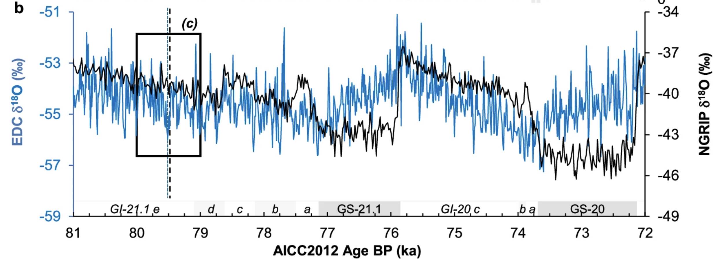
So did Toba change the climate in a way that Atitlan did not? That is often claimed. But it is not so clear from the record. We see what happened but need to deduce the causes. Around the date of the Toba eruption, there is an initial peak at 74ka (only in black, Greenland), followed by a decline. There is a brief deeper dip at 73.6 ka, which is especially notable in the blue (Antarctic) ice core.
Looking harder, the long cooling started arund 74.2 ka. If the deeper dip is due to Toba, then that cooling is not related to the eruption. The decades-long dip could be eruptive but the 2000-year phase is probably not.
In both Toba and Atitlan, there was a cooling, severe enough to show up in the ice cores and in the ocean fauna. So yes, super-eruptions are bad news. If one were to happen now, we would be deep in shit trouble. But they do not have lasting effects. Over decades the climate returns to what is was before, or at least where it would have been without the eruption.
Bt if that is the case, why do flood basalts have much longer-lasting effects on the climate? That is because of how they affect the climate. Super-eruptions produce sulphate, and this drops out of the atmosphere over years. Flood basalt produce copious CO2 and this lasts much longer in the atmosphere. Sulphate cools – CO2 warms. Flood basalt cause hot-house climates which last for tens of thousands of years, and which have been linked to several mass extinctions. Super-eruptions are bad, but flood basalts are devastating.
From past to future

Should we be concerned about the next super-eruptions? That is a ‘yes’: if one were to happen, there would be significant trouble and a lot of people would not survive. There have been at least three super-eruptions in the past 100,000 years. That suggests one per 30,000 years, so over a human life time, a chance of 1 in 300. NASA would call that ‘safe to fly’ or ‘human rated’ (which is based on a chance of loss of spacecraft and crew of 1 in 500). (The space shuttle reached 1 in 50, explaining why we no longer fly it.) So yes, we should be concerned and do research into predicting them, but we do not need to be overly worried. The chance of a VEI-7 in a life time is about 1 in 3, so we should really be prepared for that. I don’t think we are.
How about a flood basalt? Those happen rougly once per 10 million years, and change the climate for a much longer time than super-eruptions do. One day we may have geo-engineering ability on a scale big enough to do something about them. We have time to think and dream, to come up with solutions for the future.
But far more urgent is that other type of flood basalt. We are producing CO2 at a rate even flood basalts did not manage. The climate effects of this are playing out in front of our eyes. We are currently on track for 3.5 C of global warming this century. We are our very own super-eruption – we are engaged in an uncontrolled experiment in geo-engineering; the tendency has moved to denial. Climate change denial is a crime with our children as victims. But denial never lasts: the next major weather crisis, like the burning of Australia a few years ago, will change the political atmosphere again. And there are positives: technology to create the energy transition is progressing fast in spite of the current political climate, driven mainly, perhaps, by the lack of access to reliable energy sources for China and Europe. And used Teslas are becoming cheap as dirt. We can still determine our own future.
We can’t control volcanoes. But we can learn from them.
Albert, March 2025

Further Reading
Ice core evidence for the Los Chocoyos supereruption disputes millennial-scale climate impact
Ten volcanoes with super-eruption potential: Part I”
Ten volcanoes with super-eruption potential: Part II
Power of the past: a compilation of 25 super eruptions and
Power of the past: a compilation of 25 super eruptions – continued.


This looks like a nice one Albert. Will save reading it for later. Looking forward to it.
A jesperian scale event woud be Chicxulub : ) but now I asks for my own destruction if I wants that one as 30 years old present, ooo hell its barely possible to even imagine an event like that a fireball plume rises second after the impact containing many 10 000 s of km3 of vaporized rock expanding to 1000 s of kilometers in diameter raining down burning spherules over Earths entire atmosphere …. : O
Volcanocafe shoutout on Just Icelandic’s channel:
Working on my Congo Article: this time Nyiramuragira! : )
Well, you might be interested in this new satellite picture of Nyiramuragira that was just published by NASA:
with a bit background information here:
https://earthobservatory.nasa.gov/images/154037/nyamulagira-brings-the-heat
Looking forward to your article!
If you look closely at that graph, the Greenland and Antarctic lines mostly track each other, except for two long (~1 and ~1.5Ka) cool anomalies at Greenland. Both of those start when the worldwide climate trend reverses from cooling to warming. The likely explanation is that during the warming trends runoff from melting Laurentide ice suppressed deepwater formation off Greenland, causing the Gulf Stream to stop far to the south of normal and preventing it from warming Greenland and western Europe.
Perhaps more disturbing is the preceding graph which has YTT (Toba) marked on it near the right. There seem to be two spikes with roughly a century separating them, rather than just one. That in turn indicates there were four supereruptions in the past 100,000 years, not three: Toba blew up twice, throwing a ~2500km3 VEI8 and then after a mere century’s dormancy doing another one that size. That likely required two magma chambers, and it would explain the very elongated Toba caldera. There may have been a separate north and south chamber with one blowing a century before the other one did. The current pattern of resurgence indicates history will not repeat there: it’s forming a single new magma chamber in between the old ones.
The other implication of this, though, is that VEI8s may occur as often as every 25,000 years, which is less than the time elapsed since Oruanui: we’re statistically due for the next one now.
And the cooling magnitude and duration indicate the effects would be comparable to those of a nuclear war, minus only the radioactive fallout.
It would behoove us to keep a very close eye on all potential large caldera progenitors. Indonesia, Central and South America, Alaska, Japan, and New Zealand all bear watching for signs of unrest. As for Europe, that ship has sailed: we have elevated unrest at Campi Flegrei, a past VEI7 progenitor, and there is a monstrously huge and hyperactive stratovolcano in Sicily, Etna, that could be headed for its first ever major caldera event.
Oh, and as for the missing sulfate from the 200 CE Taupo event, the obvious explanation is that it erupted through water and this scrubbed it, as happened at HTHH, which was comparable in size to Pinatubo but produced very little stratospheric sulfate. Most likely the eruption originated under the lake that occupies the Oruanui caldera.
The first caldera of Yellowstone was multiple eruptions over a few centuries too, unless that isnt accepted now.
If the same is true for Toba, it probably should be counted as a single related event not two statistic points, its equally likely to be a single eruption or two that were separated by a time that is long on human scale but still short in geologic time (decades). So the YTT might be 2 eruptions but its a single event still.
That doesnt actually change the chance of a VEI 8 now at all, by the way. There needs to actually be a capable volcano at the stage it could do it, I dont know if anywhere is dangerously close. There are a few volcanoes that might not cross the 8 threshold but would behave like it though. Corbetti in Ethiopia might be a dangerous option now, as it is in the same rift zone as Fentale which has just rifted.. Etna isnt ready though, its probably at the opposite end of the scale actually, currently an open hole and rapidly growing. Campi Flegri is harder to ignore though…
It seems obvious that the biggest Toba eruption was accompanied by winds from the east or south-east as most material is found in India whereas in Australia there is much less or very little which might have been eroded away.
And in South Africa people might have even taken advantage:
https://www.uow.edu.au/media/2018/ancient-humans-flourished-through-supervolcano-eruption.php
https://www.nature.com/articles/nature25967
I would dare the guess that Campi Flegrei/Epomeo/Vesuvius would not surpass a VEI 6 at the moment as there is not enough uplift.
Anyway, the locals in a densely settled area like Naples should always be in the foreground of precautions.
You put your finger on a weakness in the paper. They did not use the highest resolution best antartic core data available for Toba, presumably because that was not the main topic of the paper. Better data shows there were 4 large eruptions within a 500 year period, the youngest of which was a double eruption, 12 years apart from two volcanoes in the northern hemisphere. The second youngest (not the double) was by far the largest and was a tropical oneL This is assigned to Toba. The third youngest was a VEI-7, perhaps twice as large as Tambora, and the oldest was a tropical eruption larger than the third, but located further south than Toba. So yes, there were two large VEI-7’s 150 years apart, followed 250 years later by Toba as a VEI-8 and 100 years later by two norther eruptions, perhaps also VEI-7’s. What a time. Toba itself seems to have erupted within a two-week period, based on the ash distribution and the seasonal winds.
https://www.sciencedirect.com/science/article/pii/S027737912300210X
A very interesting method was used to calculate YTT duration (see Ledbetter & Sparks, 1979). Eruptive duration is the difference between settling durations of the largest ash particles and the smallest ash particle at the level of the last largest ash particle. This method works as long as all eruptive parameters (height, rate, wind, currents, etc.) stayed mostly constant through out. But ultimately this assumes ash particles were settling continuously. If YTT was multistage with long pause in between, then this method only gives the duration of one of its stages. At Bakara, there’s reportedly unconformities and sharp cooling breaks in YTT ash-flows (see Caress 1985 in master’s thesis). This would be the evidence that the eruption of YTT was not continuous.
With regard to LCY, the paper interestingly notes:
“One individual shard also matches LCY geochemistry, and it is deposited in a sample ~16
years prior to the LCY population in NEEM … it is worth noting the subtle differences in
geochemistry between this single shard and the later LCY population mirror changes in
geochemistry through the stratigraphy of proximal LCY deposits, with more FeO variation
and lower SiO2 in later ignimbrite and surge phases than the initial ash fall. This scenario
would require a hiatus between at least 2 eruptive phases of LCY” (p. 3 & 7).
I say this is good evidence that LCY is at least two stages separated by a decade and a half.
Nice article, it’s good that Lo chcoyos is getting good attention in the last 5 years. I find VEI 8 eruption quite tedious to study since so many things are uncertain, it’s hard to say what exactly would happen beyond “bad things”.
Pinatubo injected 14-22 Tgs not 1 tg
The post actually meant to say that Pinatubo was at the low end of the climate impacts, i.e. 5 Tg, not 1. This is clarified now. The value you quote is for SO2. Subtracting the O2 from the mass gives the 5 Tg of sulphur. This can be quite confusing in the literature: some quote the molecular mass, some that of sulphur only
I see. Thanks.
As usual a very solid and interesting piece, thank you Albert. Also with your usual sense of humor (“be like Manchester, Jesperian”, reference to Tallis and our man on the ground, smile about all).
“The Oruanui eruption was a series of perphaps 10 events which together accounted for the ejecta.” This leads me to a question. When there are many eruptions one after the other how can scientists take these apart? Can they take them apart by dating of rock ages – has it become that precise?
Extremely fascinating the paragraph about Lake Atitlan/Los Chocoyos. I wonder here whether some of the material would have also ended up on the much older – we have to add three zeroes – Caribbean Plateau, albeit not measurably as eroded in the course of the millenia.
Close neighbor:
Last but not least the whole Pleistocene had glaciations up and down, big glaciations, melting in between. So, I believe that the melting with its considerable uplift might be a contributing if not a trigger for those enormous eruptions. In case they happened in a phase of melting the climatic effects in the sense of cooling (~6 degrees C as you wrote) might have been mitigated. An eruption in the middle of a glaciation might have caused more severe cooling for a longer period with us not being here discussing such things.
This would mean that an eruption above VEI 7 might not be seen in this world which is either at the end of Pleistocene glaciations altogether or in an inter-glacial.
small corr.: contributing factor
Very nice also to subtract two volcanoes and get to a circular crater lake.
🙂 small potatoes for humour
A jesperian scale event woud be Chicxulub impactor 🙂 but now I asks for my own destruction if I wants that one as 30 years old present, ooo hell its barely possible for any persons to even imagine an event like Chicxulub a fireball plume rises second after the impact containing many 10 000 s of cubic kilometers of vaporized rock expanding to many 1000 s of kilometers in diameter later raining down burning reentering glass spherules over Earths entire upper atmosphere …. : O the whole upper atmosphere woud cook, glow like an glass oven for hours after the impact, things looked pretty bleak indeed for the helpless dinosaurs on the ground, most of them simply too large to find good shelters underground
Dear Jesper,
I do in no way believe in the Chicxulub scenario, 1) that it happened at the described angle, 2) that it hit a shallow ocean as unfortunately (for people propagating this) there was a deep ocean in Place, the American part of Tethys definitely subducting somewhere as old like Methusalem.
That thing ended up in deeper water than we see today, and we also have to imagine that between both Americas there was a passage which would have led to an outrageous tsunami which took the guys in the Hell Creek Formation (Tanis) down at the same time, all died in the same spot, washed up there.
Very grim stuff indeed for an hour or two perhaps large parts of the planets atmosphere may have become as hot as an incenirator oven due to infalling reentering ejecta spherules small land animals where safe from that heat pulse insulated in burrows.
A 10 – 14 kilometers wide asteorid hitting a 4 to 5 kilometers deep ocean makes very little diffrence from hitting land or a shallow sea.. an asteroid or comet with the diameter of about 10 km or more were to hit in a large deep body of water hitting the surface, there would still be an enormous amount of superhot vapour debris ejected over the upper upper atmosphere. The low density ocean is just a thin layer at these scales and speeds confirmed in simulations, many 10 000 s of km3 of seawater woud vaporize as well
It might not make a difference for the Americas, but a huge difference for parts of the globe further away say Asia, Australia. Europe was closer to North America than today and Africa to South America.
You know those imaginations on youtube with clocks built in describing how everything would die, right?
If it had happened like the big shot said everthing would have died. It must have been different as not only sharks, small snakes and some flying dinosaurs survived, but also the mammal and the early bird. With the Alvarez-scenario taken 1:1 we would be absent from this world. But the media love the scenario. Once upon a time.
More species and more individuals survived than at the time of the Permian extinction.
Chicxulub s impact angle makes little diffirence in global effects you still get a massive ”hot fireball plume” rapidly expanding to thousands of kilometers wide raining down reentering glass spherules over the entire atmosphere. A low angle woud send the rock vapor directly towards Texas so perhaps even much more destructive than a 90 angle impactor for north america at least
Not everything died, but specialy large land organisms unable to swim and unable to find underground shelter from firestorms and unable to endure food starvation an impact winter did not make it through the KT impactor. There is a global KT layer of soot and glass spherules
The ocean was a very good place to escape from the ejecta firestorm: the impact was way too small to heat up the global oceans very much, but the impact winter starvation hit large sea organisms with high metabolisms souch as mosasurs and others large high metabolism sea carnivores
The Impact Winter was just as probematic for the biosphere as reentering ejecta heating up the atmosphere just after impact. I have been reading that the Asteorid winter after KT impactor lasted more than 10 years and the first half of that woud have been very cold and dry severe indeed, Most global rainfall simply crashed in most areas on the planet and incomming sunlight was so weak that plants coud not grow well at all for over a decade. Earth woud be dry, gloomy and cold quite problematic for large warm blooded dinosaurs that needed alot of food
Yes, that is believable. During these at least ten years the rest of the dinosaurs might have died for the lack of food for their many tons of flesh.
What is unclear about it though is the (the paper underneath says “poorly understood” is the precise mechanism concerning climate and extinctions of flood basalts.
Continental Flood Basalt Province K/Ar (Mys) 40Ar/39Ar (Mys) Extinction boundaries (Mys)
Columbia River 17 ± 1 16.2 ± 1 Lower/Mid Miocene 14 ± 3
Ethiopian 35 ± 2 36.9 ± 0.9 Eocene/OligoceneIr, mt/t, q 36 ± 1
North Atlantic 62 ± 3 60.5 Late Paleocene 59 ± 1
Deccan 66 ± 2 65.5 ± 2.5 Cretaceous/TertiaryIr, mt/t, q 65 ± 1
Madagascar 94 ± 1 87.6 ± 0.6 Cenomanian/TuronianIr 91 ± 1
Rajmahal 110 ± 5 116 ± 1 Aptian/Albian 113 ± 3
Serra Geral 130 ± 5 132 ± 1 Jurassic/Cretaceous 137 ± 7
Antarctic 170 ± 5 176 ± 1 Bajocian/Bathonian 173 ± 3
Karoo 190 ± 5 190 ± 3 Pliensbachian 193 ± 3
Newark 200 ± 5 201 ± 1 End-Triassicq, Ir 211 ± 8
Siberian 250 ± 10 250 ± 1 Permian/TriassicIr? 250 ± 1
https://www.sciencedirect.com/science/article/pii/S1674987113001138
The firestorm theory is real too that simply what happens when you eject many 10 000 s of km3 of small glass droplets at 25 000 km an hour into space and letting them reenter like space junk burning up
Imagine the friction and glow in the atmosphere when that ejecta curtain and glass cloud falls back into the mesophere, the energy from these reentering spherules is simply beyond mega collossal .. still its debatable if the entire planet burned but there woud be alot of heating and there is a global soot layer from ( forest fires ) from KT
Sure. You can see though, also with the fires today that fire saves some places, spots, also certain plants and also, that it makes a difference whether a region is moist or humid or bone dry like Los Angeles before the storms set in.
You have to imagine the North-American West partly under water. California was not in place. There were numerous island arcs. It is by no means understood whether the Western Interior Seaway was completely gone or not. The Panhandle of Texas might have been subaerial, but not much more of Texas.
The Rocky Mountains were not completely raised (from ~80 Ma to ~55 Ma).
The Missouri River did not empty into the Mississippi River, but into the Hudson.
It was a totally different scenario, and there was water in many places that have by now been uplifted, including the Colorado Plateau which has been uplifted in three phases, the first from 70-50 Ma and was then perhaps 300 m high or a little less or more (uplift altogether ~2 km).
An old very deep ocean in the south linking the relatively new Atlantic Ocean to the Pacific Ocean, therefore totally different currents. The Caribbean Plateau possibly still in the Pacific Ocean if the migration theory happens to be correct.
With the different currents different winds of course. No “Pineapple Express” I guess. Storms and lightning right away, but after that the direction of winds played a decisive role.
So, there might not have been as many wild fires as you imagine (being also a little pyromanic? 😁)
One thing is certain: The creatures in Tanis were washed up there by a flash flood or a tsunami. They contained spherules. Whether they died from the flood or before is not that important. What speaks against their dying first though is the fact that they are intact.
With blasts things and creatures are torn apart. And yes, might burn leaving nothing there for fossilization.
This will be discussed for decades to come and needs many sets of glasses to be looked at. One set though is superfluous: Sensationalism. This goes for Yellowstone as well. And for future meteorite strikes.
No pyromania just finding the KT strike a really magnificent thing for soure 🙂 its stuff of insanity really millions millions of times the energy of tsar bomba, its litteral hell on Earth anywhere on the planets dry land surface woud likey been have leathal to life an hour after the impact or so certainly makes st helens seems like a dwarf
If you where standing in a boat in florida at KT you woud die from thermal radiation before the tsunami hits because you are very close to the hot ejecta plume and light travels much faster than any tsunami does. I guess thermal radiation from reentering spherules may kill dinosaurs at Canadas coast long before the tsunami hits, but as you say Hurricane katrina woud be very analougus to much US days after the impact, hell on earth charred tree trunks, flooded lands, debries, dead dinosaurs, slurry everywhere under a dark gloomy sky
https://www.lpi.usra.edu/science/kring/epo_web/impact_cratering/enviropages/wildfiresweb.html
Here is a GIF of impact generated wildfires / or high heating froms spherules, maybe antartica was quite safe from that minus the impact winter
Florida was NOT there. America was significantly smaller, big parts under water or not accreted yet, less sediment. All this deep!water would have caused a gigantic tsunami.
66 Ma
https://prehistoric-planet.fandom.com/wiki/Map:Earth_(66_million_years_ago,_Maastrichtian_Stage,_Late_Cretaceous_Period)?
77 Ma

The link to the 66Ma image goes to a page with a rectangular socket where the image is presumably supposed to be, but no image.
Try again. I get a map using a new tap with plus and minus to change the size
Or this one:
https://s-ink.org/paleo-surface-topography
And that one brings up a full-screen animated gif saying “s-ink is loading” that “loads” forever.
But the image is visible there if one disables CSS.
Why, why do websites do this a lot these days? What’s the purpose of having a “loading screen” for a page that will already have loaded in a fraction of a second, especially when the “loading screen” requires a bit of know-how to bypass to view the actual page?
It might be a connection issue on your end B.Bound, it loaded quickly for ne and the picture in the comment is visible too.
And Im in Australia where our premium internet speed is about the same as rural 1 bar connection in Hawaii (not joking, primary source…) so I assume your speed is not the problem. Maybe try clearing the cache and cookies.
I meant if you where in a boat..floating above what woud become Flordia later. Because light travels much much faster than any tsunami does of course so you are grilled by the impact flash long before you are hit by the megatsunami. Tsunami woud still be crazy of course I seen simulations of kilometers high waves
There would only be km scale tsunami if the impact actually happened in water that deep though, otherwise it would blow across the surface more. There would be some push at all depths directly but not necessarily any displacement which is what you need for a tsunami.
In the case of Oruanui, there is minor erosion and reworking in earlier ash units before the next ash unit covered them. That’s how we know Oruanui ash did not fall continuously but was intermittent.
@denali,
I read a good paper a few years ago about effects of glaciations on eruptions and eruption rate. From what I remember, the takeaway is that as deglaciation occurs, there may be a spike in activity, but that doesn’t necessarily mean larger eruptions. And it wasn’t necessarily as large as one may think.
Meanwhile, glaciation and ice ages was potentially linked to higher intensity eruptions since an ice cap overlying any volcano will add significant pressure to the underlying magma. In short, ice caps, which are often extremely thick during intense ice ages allow magma chambers to grow larger and more pressurized. As a result, larger magma chambers and greater pressure means a higher likelihood of larger eruptions.
Given, this is going off memory, but it makes sense.
Thank you very much. It makes sense for all those large eruptions during the Gelasian, a time period at the beginning of the Pleistocene, which the American West west of the Rockies and also Canada are riddled with. And those ice sheets were huge.
Besides I agree with Carl that large eruptions have s.th. to do with water.
I think it is utterly fascinating that west of the Rockies it seems hard to walk without a volcanic field under your feet. Of course, numerous island arcs and terranes and uplift plus extension have added to that. For me, it is one of the most interesting geological histories in the world, only visible though for those who are not only interested in active volcanoes, but also the history of volcanism.
the other effect, somewhat opposite, can be reduced pressure on coastal volcanoes due to lower sea levels, which can also trigger eruptions during the coldest periods.
Changing sea levels would have another effect: depending on the sea level, the same vent might produce an effusive or a “dry” explosive eruption (subaerial); a Surtseyan eruption up to an HTHH type explosion (shallow water, with water able to flood the vent); or just effusive pillow lavas (deep water, where pressure is above water’s critical point and steam cannot form and where most magma-borne volatiles also won’t explode). Changes in sea level may move the vent across the threshold for changing which of these cases applies.
Subtler: the volcano, if it tops out near sea level, will be subjected to different erosion. For example, if a volcano is just below the waves, with erosion knocking it back faster than it can gain height as soon as it pokes up into the shallow zone where waves add to the erosion, but then sea levels drop substantially and make the summit subaerial, it may now start growing vertically without difficulty. When sea levels return to their former normal, the volcano may have grown enough to still be subaerial and if solid lava flows (and not just tephra) have helped build it and make it hard for waves to erode it will then have become a permanent island.
Even a VEI 6 is sufficient to give us the creeps:
https://www.nationalgeographic.com/science/article/colossal-volcano-behind-mystery-global-cooling-found
10,5 cubic miles or 43,76591 cubic kilometres of tephra makes it a higher VEI 6 that – quote “killed tens of thousands and helped trigger one of the worst periods of global cooling in the last 2,000 years.” The piece is about Ilopango, San Salvador.
Thanks for the link: Im soure that the Chicxulub Winter makes that look like childs play
Yes, agreed. Chicxulub winter is s.th.I agree with. What also points into that direction is the dying of all mososaur world-wide which means that the temperature of oceans and currents might have changed quite drastically. Mososaur used to live close to the coasts whereas sharks can live in deep water.
Mososaur is discussed as a relative of the python. The land based python though can eat only twice a year and hide in caves like all snakes. Mososaur, said Michael J. Everhart (Ocean of Kansas) had to eat all the time.
Mososaur fossils are abundant on the banks of the former Western Interior Seaway (Kansas Ocean), but have been also found in places like Russia or Morocco, not to forget the name patron River Meuse.
Besides Popigai, smaller in size, seems to have caused a bottleneck, at least in Asia.
For ocean animals the ejecta reentry firestorm woud not be a problem at all water insulates and haves a high heat capacity. An asteroid 10 kilometers wide is simply not large enough to heat up the worlds global oceans
To boil the worlds first 100 meters upper global seawater you needs a 45 kilometers wide asteroid or comet .. and thats so much kinetic energy that results in global land sterilisation. A 500 km wide protoplanet is needed to completely boil away Earths oceans ( that results in a terrfying rock vapor atmosphere)
Again: Those fish found in Tanis were by no means boiled. They were fossilized in mud being washed up there, intact. They came from a river, the Western Interior Seaway in case it was still in (reduced size) existence or the ocean in the south which was then Tethys and is now the Gulf.
Paleontology can speak a very precise language.
Thats because these fish sheltered in deep ponds.. anything out of water where broiled by either the fireball or most likey thermal radoiation from reentering fine ejecta here is some intresting charred tree trunks https://www.forbes.com/sites/davidbressan/2022/09/07/dinosaur-killing-asteroid-triggered-continent-wide-firestorm-within-minutes-of-impact/
There is soot and spherules all over the world so likey where perhaps global forest fires, even in New Zealand these can be found
Thats saied the Impact winter is just as bad …and was perhaps the biggest killer
Forbes? No, Thanks.
“As that material hurtled back into the atmosphere it heated the atmosphere, in some locations generating wildfires (middle panel).”
You scroll down to the middle and take a look at the movie. After that you best get yourself a rational map with the right sizes – I will get it. Then you might see – if you want to – how much was saved.
https://www.lpi.usra.edu/science/kring/Chicxulub/global-effects/
https://www.onestopmap.com/world-maps/world-azimuthal-equidistant-north-pole-centered-477/
1. The guys drowned before they could burn, that is why there are fossils at all.
2. We cannot see whether they all died in one day, one year, 10.000 years or 100.000 years. we cannot use ice bore holes for that or tree rings, too long ago. So, precise timing becomes difficult with geological age. There is the age of rocks of course and Argon-Argon dating and other methods, but the longer ago s.th. happened the less precise it is.
3. Asia and the northern areas might not have burned, the tsunami of course was present, albeit smaller.
4. But food must have become sparse there as well, and water undrinkable due to sour rain.
Scientists are not of the opinion that this is fully understood and tend to multifactoral causes, the Deccan Traps which influenced oceans and reduced Foraminifera which had already damaged the food chain. Besides, as Van Andel, Dutch Paleontologist described well enough, species have bell curves and are done at some point going down after the largest spread. These were at their very end, mainly because they had no natural predator.
They, already decimated, probably died locally right away, in North America after 10 – 60 minutes depending on the travel time of the tsunami, in other parts of the world because of fires, tsunami and food shortage. They certainly – some of them – lived on for a while, how long is unclear.
But one thing is clear. It is said about a WWIII with the Atomic Bomb that the surviving might envy the dead. And this might also go for the dinosaurs aside from the fact that animals do not have this kind of envy.
We should not forget that the climate afterwards was potentially more beautiful, but cooler, and also that the air pressure was different, so their time was over.
From link: (when results are inconclusive a well preserved tree might help)
“This was why Dull’s team was excited to hear about a quarry about 10 miles from Ilopango, where workers digging for road fill had found intact trees within the Tierra Blanca Joven. At the time of the eruption, gently falling ash had entombed the trees where they stood. “One looked like a freshly fallen tree,” says Dull. “The preservation conditions at that site are some of the most remarkable I’ve ever seen.”
Because the trees were so well preserved, Dull and his team could figure out how old they were when the Ilopango eruption killed them. These new data—a hundred new radiocarbon dates—point to the trees dying in the first half of the 6th century, most likely in the 530s to 540s.”
Thank you for a very interesting article, Albert!
To Albert
Concering double features I have recently read about this candidate:
“The southeast side of the larger 10×13 km caldera contains a caldera lake. Both the larger caldera, and a smaller 7.5 km caldera were formed by a collapse of the magma chamber, the first larger collapse taking place about 29,300 years ago, and the second inner caldera collapsing about 20,150 years ago. Another estimate of the inner caldera’s formation date, formed during the emplacement of the Bali (or Ubud) ignimbrite, has been dated at about 23,670 and 28,500 years ago.”
https://en.wikipedia.org/wiki/Mount_Batur
Bali, close to Agung. The timing is close to Oranuoi:
“The most recent VEI-8 is the Oruanui eruption (1170 km3), which happened 26,500 years ago.”, quote Albert
As the most important volcanic eruption in the past 250 years both came from Indonesia and the Philippines, Bali and also Papua New Guinea with Rabaul and Tarvurvur should always be in the focus and probably are.
Impressive caldera, and also Vulcan on the south-western rim is active. Size: 8×14 km, slightly bigger than Thera Caldera.

Often after a caldera-forming eruption the new volcano will form in the rim fault. So when that volcano explodes you get two partially overlapping calderas. That may be what happened at Batur
Thx
Wonder if that applies to basaltic volcanoes as well. There’s evidence for at least three at Mauna Loa (and a fourth, huge older one).
One could rationalize that Kilauea Iki is one as well.
Let us go back to super volcanoes, Jesper.
The chance of a meteorite (2024 YR4) hitting Earth in 2032 is 0,004% says NASA.
https://blogs.nasa.gov/planetarydefense/2025/02/24/latest-calculations-conclude-asteroid-2024-yr4-now-poses-no-significant-threat-to-earth-in-2032-and-beyond/
Avoid youtube.
Chances of a VEI 7 are higher.
Depwnds on the size if a meteor. An airburst Tunguska event or a ‘small’ (under 1 km wide) impact crater are probably about as likely as a VEI 7 and probably more dangerous given its pretty easy to avoid a volcano but not an asteroid. I dont know if impacts can be much smaller* unless they go fully vertical to limit travel in the atmosphere but airbursts happen every year so its pretty common.
( I guess airbursts still do reach the ground but at terminal velocity, I mean hitting at orbital velocity there is probably a practical limit)
I dont know the status of that recent dangerohs asteroid with the impact risk in 2032, it was pretty unlikely as I last saw though, but theres definitely millions more things like that out there.
You are of course right with the size. An airburst might have destroyed Tall-El-Hammam near the Dead Sea.
I have to mention though that Albert is no fan of this theory:
https://www.nature.com/articles/s41598-021-97778-3?error=cookies_not_supported&code=3caca6d1-5cd2-478e-b1d7-d9795268c7f7
By 2032 at least Elon could push 2024 YR4 away or blow it up. Assuming he can get his enormous rocket to work – and that’s pretty close despite the recent fireworks.
No one has worked out how to defuse a volcano though.
Another suspect for a big eruption is Mount Tondano, Sulawesi, with a 20×30 caldera.
Mount Tondano is in the North Province (green) near Manado. There are often earthquakes in the tectonically active Gulf of Tomini and Sea of Malacca – I often take a look where they happen, mostly at a safe distance of Tondano. I think trust into that setting is not justified.
Mount Tondano is a Somma Volcano like Mount Batur, Taal, and Anak Krakatoa and Tengger, Java, in North America St. Helens and Mazama (Crater Lake), in Europe Alban Hills (Help!), Somma with Vesuvius of course and others, in or near Africa Teide and Piton and so on.
My trust in the area is low.Mount Tondano is a builder, on its rim there are Soputan, Sempu, Lokon-Empung and Mahawu of which only Sempu has no record in historical times. Sempu boasts a maar to make up for this fact.
Lokon-Empung is two guys with a crater in between.
Just noticing that Carl has no trust in the guy either:
https://www.volcanocafe.org/did-you-notice-the-erupting-supervolcano/
Wrong. Reading helps.
Carl thinks the guy has a lack of water, here we are:
” For those who dream dark dreams about enormously destructive eruptions Tondano is a bad bet. Why? Tondano has it all really, large magmatic influx, steady inflation, a large central chamber, active volcanism. Pretty much everything that it should need for a VEI-8 eruption. Except for 3 small things.
It does not any longer have the amount of water necessary to drive an eruption like that. As many of you know water is a large part of large caldera events. When Tondano went massively caldera it was situated pretty much at ocean level, so as the final large eruption (probably a large VEI-7) happened and the top of the caldera slumped inwards the ocean roared in and what is probably the largest steam explosion happened.
Taupo maybe most likey for next VEI 7? its a very active sillic caldera system after all
It has done one recently though too, its active but it doesnt erupt on that scale often. It has done VEI 5-6 many times but 7 is rare, and the eruption in 200AD might have been a failed VEI 8 that didnt runaway collapse. I guess maybe it still has all that potential but it seems weird it would just stop and do nothing since if that was the case.
Probably the two active volcanoes most capanle of a VEI 7 are Ioto and Yasur, but chances are still pretty low that it actually happens really soon. Although not low before 2100. Corbetti might be a dangerous wildcard now that its wider rift zone is active, but it presumably is hard to set off given its huge rhyolite lava shields. I guess past that really is a bit of an unknown.
We need a big eruption right now in this rather modest economic situation like a goiter.
Accordingly the next big one can only come from this lady, for sure:
Nomen est omen.
Putana, Chile
“we have our man on location tasked with keeping an ear to the ground”
So far all he hears is crickets.
Dangerous things, these crickets. Oops, sorry – that is Australia
I read recently that rattlesnake can sound like crickets, but that would be in America.
Kilauea episode 14 is about 2 days away, maybe 3.
The last map was made just before episode 12, and that was at 52.5 million m3. There was 24 microradians of combined drop on the tiltmeter for E12 and E13, so maybe another 10 million m3 on top of that for about 63 million m3 of lava now. The caldera is filling quickly, already the June 2023 cone next to the vents is nearly buried and that was about 40 meters tall, and the September 2023 vents are not much better off. The top of the cones is probably over 1000 meters elevation now although the vents arent yet.
The length of time actually actively erupting is about 19 days out of the last 84, and the eruption rate about 3.3 million m3/day, or 38 m3/s. But this is partly because E3 was very long, the average rate now is much faster, probably hundreds of m3/s at peak output.
Finally had time to read it and it was worth it as usual. Nice writing, a good balance between humor and seriousness, followed by interesting discussions in the comments. I think I’ll pass on both the flood basalts and the VEI8 eruptions, none of the outcomes seem very nice.
I’m feeling a bit frustrated at the moment. Here I try to get people to think before they react to changes in GPS data and not only look at a few samples of the up/down-component. Then this facebook page run by two professors and one associate professor at the University of Iceland does the opposite and posts that subsidence has started and magma might already be migrating towards the surface, when the error bars are all over the place, other stations several tens of kilometers away are also “subsiding” and the horizontal deformations don’t show anything of what they are expected to do once magma get on the move. I give up…
I feel like now is a good time to thank you for your really, really insightful comments on here.
Thank you! I appreciate that. I guess it’s my way of learning stuff. Explain it to someone else and you have to understand it yourself first 🙂
I enjoy the chances to learn something, and one way is to open a discussion with my incomplete knowledge. Here we have the opportunity to let education and entertainment meet each other.
Lots of shallow quakes today at Bardarbunga.
Some quakes at Hekla too deep to shallow.
I’ve read in an article about Hekla that the normal earthquakes there belong so SISZ, because Hekla is half SISZ and half EVZ. So the normal earthquakes are part of the non-volcanic SISZ, while the magma chamber sits somewhere below. Hekla sits on the junction between SISZ and EVZ.
https://jokull.jorfi.is/articles/jokull2005.55/jokull2005.55.087.pdf
” The seismicity at Hekla and its immediate surround
ings is quite unique and has a dual nature. In non
eruptive periods there is little seismicity and the few
earthquakes that do occur are not related to the vol
cano itself. Instead, they have the same characteris
tics as the seismic activity in the South Iceland seis
mic zone located to the west of Hekla.”
“Volcano
related seismicity occurs at Hekla in the form of an
initial earthquake swarm, continuous low-frequency
tremor and eventual sporadic small earthquakes dur
ing later phases of the eruption. The eruption-related
seismicity starts only tens of minutes earlier with a
swarm of hundreds of small earthquakes which in
crease in size towards the onset of the eruption. The
sizes of earthquakes, ML < 3, culminate around the
very start of the eruption. "
I just think the network wasnt sensitive enough before, now it is and is picking up the minor seismicity Hekla has always made. It hasnt erupted in 25 years so no way to test, but I am going to put it out as my prediction that Hekla wont erupt with 2 quakes 10 minutes before, its going to be visible suitably in advance to actually watch it happen, a few hours at least.
I guess to compare, how many quakes would you actually feel before Kilaueas eruption started back in December. We knew it was coming because the magma is shallow. Heklas magma is deep, but not so deep to be undetectable, I would think we see some microseismicity if it is close to failure. Its been too long to hold any kind of open path since 2000. In 1845 people near it could hear the quakes a day before when in bed.
Maybe hiking with wood shoes or no shoes is better, lets you feel the quakes more, animals dont wear shoes thats why they seem to feel it faster 🙂
That’s true. For me it was new that Hekla mixes with the non-volcanic SISZ, maybe this explains its unusual volcanic behaviour.
After three days without internet, I finally have the opportunity to read the article!
Looking at Meteorology/Climatology we can distinguish three possible consequences by volcanoes or other natural factors:
1. Longterm climate change for thousands to millions of years
2. Shortterm climate change for a few years or decades
3. Weather change, f.e. drought, floods, different position of cyclones/anticyclones …
As far as I have understood it, longterm climate changes are nearly impossible by volcanoes. There was an exception, when volcanoes rescued us from Snowball Earth. But that was not a singular eruption, but probably the sum of all eruptions with CO2 emissions. Flood basalt is probably also a possible trigger for longterm climate change. But all of VEI eruptions, normal asteroids and even nuke armageddon wouldn’t cause longterm change.
Atitlan had an impact for 20-30 years, so a shortterm climate change. An event like this would be an Armageddon for nature and humans, but not the change towards glaciation.
The change of weather systems can be very hard and serious. It can be very different depending on the wind systems that are interrupted by a lot of tephra injection. Tephra also means more condensation nucleus in the atmosphere.
Update from IMO:
https://www.vedur.is/um-vi/frettir/reykjanesskaginn-2024
They have investigated the cause of the shift in earthquake locations towards the east and found that interference in one of the seismometers has caused a bias in the measurements. In other words, the situation is the same as before previous eruptions and the recent uptick in seismicity means that the next eruption is very close now.
This serves as a good example that locating earthquakes is delicate business. A small error in one instrument is enough to shift the estimated locations by 500m.
I wonder if it will reach the ocean this time. It has a downhill path unobstructed on both sides of Husafell now, and the more northerly one wouldnt destroy any structures except the road. If the fissure line is slightly east of the average point it will mostly flow that way anyway.
In any case this one is probably going to be big, so either the longest curtain of fire to date or even higher output at a normal length. Or it lasts longer with higher output. The eruption last August erupted all the way at the northern tip of the November 2023 rift, but the southern half is still non eruptive. Its not as likely but the risk of an eruption in Grindavik is real… I understand why it was done but its crazy people are allowed to stay there.
The longterm graph became flatter and flatter with each episode. The question is: how flat has it to be to shut down this series of episodes?
My feeling is that 2025 we only get two episodes
Didn’t someone stack these graphs on top of one another to show exactly that, and the flattening of the curve was very pronounced. I’m sure I saw that in the chat somewhere and am not imagining it.
I think it looks like the system has only just reached last Junes level, now, so maybe we’ve all been too early with our forecasts for this episode.
I think it will keep going until the magma supply goes elsewhere, maybe to Krysuvik if that is close enough, or to the tip of the peninsula. But until either an eruption or sill formation at shallow depth happens at either of those Sundhnjukur will keep erupting. Fagradalsfjall erupted over a more than 2 year period and it wasnt actually completely dominant during that either, unlike Sundhnjukur now. So theres still at least a year left in this yet and possibly longer.
Longer intervals might result in bigger eruptions. Slower deformation results in less stress, its already sort of visible in the graph. The supply rate is still very high and eruptions have been getting bigger just as fast as they are further apart, so its a bit naive to call it ending yet.
Its also something important to add that Krysuvik is the same sort of fissure system as Sundhnjukur but is much bigger. Over twice the length and minimum estimates of eruption volume of both of its 1150s eruptions is more than Sundhnjukur has erupted in total since 2023. It is basically the same volcano but Reykjavik is in the firing line in a worst case. That doesnt include the risk of it erupting in the valley containing Kleifarvatn…
The inflation rate has really plateaued in the last week.
Despite that, or maybe because of that 😀 , IMO is saying she’s ready to blow.
Larger eruption with less warning thought likely (RÚV, 17 Mar)
Volcanoes are like cats, they never do what you think they’re going to do.
Remove the last week and you had a similar one week plateau before that. Remove that week and you had one before that. Draw a line through all three and find that the slope matches with the rest of the graph.
These are just natural variations in the GPS data. There is a slow overall decrease in the rate, but the short term variations are probably just arefacts related to the noise in the measurements.
If we look at the Krafla fires, we see a very similar trend in the inflation/deflation of the caldera. In the beginning of the series, there were roughly 3 events per year (counting also non-eruptive dyke intrusions), then two events in one year, followed by a one year wait. Then there were four smaller episodes during 1980, followed by a one year wait, followed by a three year period before the final eruption in 1984. After that, inflation continued for a while, but no more eruptions took place. Total length of the Krafla fires was from 1975-1984, (or 1989 if you count post eruptive inflation).
Now, Krafla is in a more purely extensional setting, while Reykjanes is is aligned oblique to the spreading axis. That could mean there’s less accumulated extension available for Reykjanes, so the sequence might prove to be a bit shorter.
At some point, this sequence will crawl to a halt. At that point we could be in for a long period of uncertainty, where inflation keeps going at a very slow rate, keeping everyone on their toes for years to come.
I’m wondering why the Medieval Fires didn’t run episodical like this. At Svartsengi were (according to eruption history) distinct eruptions several years apart. Did no episodical eruption like ours happen or did they miss to report one? Eldgjà happened during the Medieval Fires and destroyed much of Iceland’s civilization, maybe a reason for incomplete historical reporting.
Krafla is compared to Reykjanes more close to the Hotspot and has a central volcano. Reykjanes looks to me more like the northern end of Iceland’s volcanoes like Kolbinsey Ridge/Grimsey. Krafla also more frequently than the “Iceland’s end” volcanoes. So a bit similar and a bit different.
It confuses me still a bit that the volcanic systems all along the Reykjanes Peninsula don’t align to the axis of the spreading MAR zone. It reminds a bit to California’s San Andreas transform fault system, but with spreading behaviour and volcanism.
My thoughts were just that the last cycle was recorded way less completely than I guess we assumed it was… Not to argue that people didnt see stuff but the only options we have are that this cycle has different behavior to the last one or most of it was either missed or condensed in reporting, the second one seems more likely.
There is the elephant in the room that in 4 years there has been two different rifting events, and all of the volcanoes on the peninsula from Þingvallavatn to the Reykjanesryggur are active by normal standards. That actually might tip the last paragraph statement in the opposite direction. It is already known that the lava in 2021 was different than the lava in the middle ages, and the lava at Sundhnjukur since last May has been the same composition as most of the 2021 lava, which is the primitive source magma of the 2022-2023 and early 2024 lava. So although controlled by the same tectonics the magma source isnt identical.
Still, Svartsebgi was being uplifted since 2020, and again in 2022 before fully comitting late in 2023. So it is plausible that this area and Fagradalsfjall might be the same system and technically one volcano. The first test was when Sundhnjukur erupted that the lava had the same source as Fagradalsfjall, and it passed. The second test will be when a 3rd system erupts will that have the same magma again. If it does, then that combined with all systems being active together has to ask if all of Reykjanes behaves as one single complex volcano.
As a side note that swarm at Ljosufjoll is still ongoing. Its weak but stable and persistent.
Tomas:
What would be a good discussion, is to ask the IMO how they suspected that one seismometer ( I assume internal timekeeping?) was off?
I dont remember seeing it actually double fountain last time but the south vent might actually be the south vents. I wonder if the middle one is evidence of the two vents merging now, which would be expected eventually. Seems they are both otherwise too well established to get clogged up any other way, sputh vent way for a while but look at it now…
Either way it might be very pretty next time in a few days, and if both can get to nearly 200 meters at the same time now a single vent could push 400 🙂
Probably closer to 300. It is quadratically harder to throw stuff up to greater and greater heights, as it’s subject to a downward acceleration throughout its upward lob. So we should probably take the square root of the sum of the squares here, which results in getting 200*sqrt(2) rather than 200*2, giving a height if all of the “oomph” behind both fountains were backing just one of somewhat more than 280m.
Yes, but the fountains have been getting stronger each time so by the time a single vent exists 400 might be exceeded 🙂
The volcano shield/field at the base of the twin cones has risen a lot, if I only look at the lava map. There is no horizontal lava lake on the surface anymore, but a monogenetic shield volcano that has the summit below the vents and slopes towards the east. It looks like a mini Pu’u O’o inside the summit caldera.
The asymmetric growth makes it likely that lava exits in the SW corner, if it grows enough. The distance is short there and accumulation is higher than the possible exists on the E and N side of the down-dropped block. 1971 and 1974 showed how it can happen in the SW part of the caldera. There is a lava canyon that takes a SE direction from the exit. Would be a great lava canyon tour, if a safe lava boat was invented. Maybe on 1st April is a chance …
April 1st in 2027 maybe 🙂
I would maybe call this one a polygenetic shield at this point, old Halemaumau probably started just like this back in the first years of the 1800s and basically survived up to 2018. Now it is that again, but it doesnt need to fill much. It is a great test if the massive supply in the 19th century just stopped too early to overflow or if the rift zones need to be completely closed off to let the summit fill past 1 km elevation and filling will be rapid to get to that point. We might get an answer within 2 years.
As for an overflow if the shield is steeper than about 2 degrees from the vents going eastwards, it will probably overflow the southwest and south side of the caldera near the vents before it overflows the lower east side, its weird like that. Its probably not going to fill neatly like that though because there is still lots of lava under the floor that can and does leak out of rootless vents to level things a bit. And if the true vents get tall enough they could intrude into the lake core directly and technically make all those rootless vents into rooted vents, like probably happened near the end of the eruption in Geldingadalur 2021. Either way its probably going to fill up quickly.
Wild card is that if the vents become completely opened up and huge fountains, the lava flows will become primarily fallout and so shorter and more viscous, so build faster. But at the same time the vent eroding also will eventually make fountaining rare or stop entirely in favor of slow continuous output that will make extremely fluid lava even more than at Pu’u O’o potentially. Thing is, being a summit vent it is probably very stable and so could well alternate between continuous output and episodes and even high fountaining many times. Its all an option.
The important bit is, by 2030 there will be lava flowing towards or into the ocean again, not if but when and where. Whether it is from the present vent overflowing down the Kau desert, or a future vent on one of the rift zones, that is unknown. But Pele is done with staying underground. Right now I pick the first option but if one or both of the rift conduits flare up again its pretty clear the final outcome…
Very exiciting indeed thats what I too are waiting for: a large summit shield and certainly will be the case unless magma moves elesewhere
I’m not sure about the altitude of the possible lava exit through the canyon. The summit reference map doesn’t help much. It indicates something around 3500 feet, but I’m not sure about. The exit must be somewhere on the left hand of the S2 webcam: ?fileTS=1742314814
On Pu’u O’o the episodes began with fissures, then several vents, before the concentrated on the more steadily erupting monopoly cone (apart from the Kūpaianaha period). It took months to change from the fissure eruptions to the Pu’u O’o cone. The episodes continued to do tall fountains (460m). Pu’u O’o’s early 1983-1986 episodes were still longer than the current Summit episodes. The first episodes in June and July 1986 lasted for four days: Episode 4, Episode 5 and Episode 6. They were short for Pu’u O’o, but long for the present summit eruption.
“aside from Kūpaianaha” was the correct expression, I hit the wrong word.
Pu’u O’o also formed in a rift zone and was not directly over the primary deep source. Mauna Ulu had similar episodes but became a single vent iimmediately as well as less separated episodes. Kilauea Iki in 1959 had only days between events so even faster than now.
Kupaianaha also was just a secondary vent of Pu’u O’o, just one that was further from it than most. Not really a new conduit per se. Same thing happened in 2007, and Pu’u O’o itself was leaking lava out its base the rest of the time even before high fountaining ended.
Anyway the eruption rate of Pu’u O’o was also lower than now, it was still high but not it is close to double that which is still crazy to think about. I would guess the reason fountains arent 400 metets yet is because of the decade of degassing Halemaumau did before 2018. So if magma becomes replaced by more primitive lava over time fountains might keep getting bigger even as the crater fills. By the time it overflows it might send huge channeled a’a flows down the flank instead of slow pahoehoe, or maybe both together.
Is the current position (or of Kilauea Iki) at the ring fault similar to the location of tephra eruptions of Kaneakakoki? We see relatively gasrich magma that does great fountains. It looks as if the magma rises relatively fast without much degassing. If this happens even more extremely with gasrich magma, it may explode during the rise to the surface as it maybe happened around 1790. Fluid alkali magma also can be explosive as we saw in La Palma, Vesuvius or the explosive eruptions of Niyarogongo. Hector once had an article about alkali magma explosions (Maar eruptions) in south Germany during Neogene age.
Until 2018 the Pu’u O’o eruption had the highest eruption rate USGS and Jaggar institute had observed. But they found that after 1790 there was an even higher recharge rate at the volcano than 1983-2018. We are probably in a similar period as 1790-1840.
Good read, very interesting:
https://news.berkeley.edu/2015/04/30/did-dinosaur-killing-asteroid-trigger-largest-lava-flows-on-earth/
Good science:
“Richards teamed up with experts in many areas to try to discover faults with his radical idea that the impact triggered the Deccan eruptions, but instead came up with supporting evidence.”
But now we know that the Deccan eruptions started before the impact, and that the impact happened during a slow period of the Deccan traps.
Yes we do, but we still should not necessarily believe that the meteorite hit shallow water because there was Tethys in place. Then the angle would be wrong too.
I think there is a consensus that the first part of Tethys that was subducted was the one that served as a magnet for India, ~55 Ma.
https://s-ink.org/paleo-surface-topography
What we can believe I think is a drastic climate change which was unbearable for the dinosaurs, but does not explain why the avian dinosaurs survived, unless they flew close to erupting volcanoes with their warmth.
Another explanation that comes to mind is that there was possibly enough food for the avian dinosaurs (fish), whereas the land based dinosaurs also starved.
A third explanation is that the dinosaur was advanced on the way to becoming a bird – even some T-Rex was found with some feathers – and that their time was over, but how.
I think this question cannot be answered completely to satisfy everyone: How come a species is done? Is there a bigger plan? Is it a cosmic plan? How does it work?
When that meteorite crater was discovered, paleogeography was not by far that advanced. Today, with dating of rocks and a huge database reconstructions can be done much better.
The fact that Mark Richards and Walter Alvarez are from the same department and bring the Deccan Traps back into the game is very scientific and also very promising.
Common ancestor of all modern birds was apparently an omnivorous small bird that lived near water. It had already started diverging by the K/Pg but all the modern lineages present in the end Cretaceous were still in this niche. Most other niches were filled by other bird lineages or by pterosaurs and non avian dinosaurs.
Also birds were just one line of dinosaurs, a T Rex couldnt evolve into a bird that would be like a dog evolving into a human. It cound evolve to look the same but thats convergence.
Anyway the dinosaurs went extinct because most of them were megafauna which is a bad thing to be if unpredictable climate change happens. I dont know why only very small ancestral modern birds survived, but among mammals only very small ones survived too, they didnt get out unscathed, so it was probably just very hard to be an endotherm is my guess.
I do want to add that Antarctica and southern Australia have no earliest Paleocene strata, and Maastrichtian deposits are on the very edges not the main continent. It is not impossible that sone other non-bird dinosaur lineage could have been more persistent on the remnant of Gondwana. Its extremely unlikely to be long lived over 1-2 million years, but if you want true Paleocene dinosaurs thats where to look I think. True Paleocene ammonites were recently confirmed so who knows, most of the best KPg fossils are in North America which was basically front row seats to the apocalypse so of course it looks bad after…
Antarctica yes. Was green then, right?
Yes, although it would have still been dark and snowy half the year there was no icesheets. I would assume there were glaciers in the mountains though. Icesheets began to form in the Eocene I think, which is when Australia finally completely separated, but only became significant in the Miocene when the Drake Passage formed and opened. Antarctica will probably stay icy until it is pulled north or the Drake abyss is blocked off, though we are probably going to nelt it temporarily the way we are going.
So Abtarctica was probably like the Yukon ir Alaska, or Siberia. Any place in the north that is icy but hasnt been fully glaciated. Lots of fuzzy dinosaurs. If I had to guess probably very close to maastrichtian Patagonia but thats a best guess. So lots of sauropods, megaraptors, abelisaurs, elasmarian ornithopods, ankykosaurs, and maybe hadrosaurs. But maybe also something like a holdout carnosaur or even weirder stuff. Modern monotremes are entirely original abd endemic to southern Gondwana now only Australia, so theres definitely a lot missing in the fossil record. I mean the early Cretaceous fossils there have Triassic holdouts, talk about living fossils, it was a last refuge kind of area.
KT Antarctica sourely got incredibely cold for soure during the impact winter, it was already pretty cold as it was already in winter season, the dinosaurs there those rare ones that did survived the firestorms and earthquakes woud must have been one of the first ones to starve/ freeze to death due to the lack of food supply the rare survivors perhaps tryed to migrate but sadely only found more darkness, cold and food starvation in the supposedly better north. KT Antarctica sounds like Scandinavia ( which is similar to Yukon at least Lapland ) a frozen hellhole for most of the year only broken by a short warm summer, Sweden looks like an Impact Winter for most of the year: its completely grey and dead
If the Tanis site is legit, then the time of year the impact occurred was in northern hemisphere spring. So Antarctica would have been going into autumn and thus was already entering its cold half of the year. So actually it might not have been any better than North America really. Its a fascinating thought that if the impact was 6 months later maybe its primary affects would have been partly cancelled by the 24 hour daylight. Or, if it had instead struck at the same time as it did in reality, but far south instead say in South America, its possible the Arctic dinosaurs might have been able to endure it.
I have seen something though, that if the impact had hit literally anywhere on the planet other than where it actually did, the effects wouldnt have been as bad. It hit a carbonate platform with a lot of anhydrite present so there was a huge sulfur emission. Its the same exact rocks that El Chichon erupted through in 1982. If it hit in the deep ocean it would have still been bad but maybe survivable. Really though it would have taken something truely apocalyptic to erase so much of the biosphere so quickly. The P/T extinction was worse in species loss and diversity but there were actually quite a lot of relatively large survivors, K/Pg by contrast had no endothermic survivors over a few kg, it really wiped the slate clean. I also wonder if maybe the much greater age of the great dying is exaggerating the loss due to preservation bias against small things, which the relatively recent K/Pg doesnt hide. At a quick glance the K/Pg actually looks like it was a way worse event to experience really.
What woud have happened if the KT impactor have hit the planets deepest marine trench back then? I been reading about detonating 2 million Tsar Bombas in mariana trench and the local deep ocean is simply vaporized instantly and a huge rock vapor cavity is formed anyway, sending crazy ammounts of stuff into orbit, but you are likley right if it have hit a very very deep ocean, woud the impacts effects have been mildered? The asteorid was sizable but Earth have had much bigger impactors than that in earlier times of course
I been reading that Its tought that KT impactor ( 10 kilometers wide ) was a borderline case, yes it was large enough for serious mayhem, yet it was also small enough to avoid incenirating the biosphere completely. Thats saied if a 50 – 60 kilometers wide object hit instead you woud only have Earthworms in very deep soils left alive on land sending global atmosphere temperatures up to 500 c for a few weeks after impact… which was not the case with KT impactor
The moments after impact crater formed must have been INSANE stuff when the huge volumes of ocean water came back rushing back into the crater thats briefly been as hotter than the suns surface ( plume ). The impact melt sheet that remained after impact in the crater was perhaps at least 2400 degrees c and the melt sheet was many km deep for Chixculub you gets a 4 kilometers deep melt sheet.
There was huge walls of seawater rushing back over that superhot surface so perhaps you got some huge ”pherato melt explosions” when seawater later rushed into the crater it woud be an incredible sight with titanic ammounts of seawater rushing into the hot melt sheet moments after the impact. Its hard to know what that may have looked like. I have also read that there was long lived hydrothermal activity for tens of thousands of years in the impact crater with ”something black smokers” when seawater seeped and circulating in hot faults
https://link.springer.com/article/10.1007/s00531-021-02008-w
https://www.science.org/doi/10.1126/sciadv.aaz3053
For KT you gets a 4 to 8 km deep melt sheet in the crater basin the interaction of huge ammounts seawater and hot impact melt must have been a fun sight! the massive seawater front rushing back in crater likey had VEI 6 pherat – melt explosions maybe 🙂 crazy sight
Oh wow the crater resourge of water makes amazon river or filling of mediterranean look like childs play in forces in terms of water resourge, immense forces and I dont think I can even picture the water resourge front in my head even, its scale beyond human imagination woud be some enromous steam explosions for soure and a hot steamy local ocean for months afterwards. I woud like to have a detailed computer simulation of this
– when seawater later rushed into the crater it woud be an incredible sight with titanic ammounts of seawater rushing into the hot melt sheet moments after the impact. Its hard to know what that may have looked like. Quote Jesper
If physicists think it was like this there must be a model.
I tend to make it surrounded by question marks, and automatically it shrinks. What if the meteorite split in several parts and another one came down on the coast of Guinea, Africa? What if the Ch.meteorite was smaller and hit a volcanic caldera? Is there any model of a meteorite hitting say Sete Cidades? If not you are perfectly able to create one. Make it smaller, ask a physicist. I know one. He measured tsunami waves in a river in Manchester (funny).
Because some of what you imagine is means to a total extinction of life. Nothing would survive. 35% though survived. For me this is the key to a less spectacular story with many facets and a longer time frame.
This data and tougths should be accurate according to rock drill cores in the crater itself and how basic physcis behaves in an impact crater event
Most of the energy of an impact event is lost to space to be reminded of, thats one reason it did not do more destruction than it already did.
To wipe out the land biosphere completey you needs an impactor perhaps 100 kilometers wide
It is no way sure or agreed upon where the Maya Block, a terrane, of which Yucatan is a part, was located at the time, and it looks as if this is still work in progress.
When I look at these events I have one thought: What if the meteorite hit a volcanic province?:
78 72 Ma Late Cretaceous Greater Antilles Arc collision into Maya Block starts
78 63 Ma Late Cretaceous–Palaeocene Chortis Block collision into Maya Block starts
This is a very active area, think rifting, sea-floor spreading, collision, Caribbean Plateau, Antilles
Terrane and collision ring bells. There was water involved – that is certain. A meteorite hitting a volcanic province would be something.
I assume that chapter is not closed and we might see many more interesting papers from there.
And also about the suspected sibling:
https://ig.utexas.edu/news/2022/mystery-crater-potentially-caused-by-relative-of-dinosaur-killing-asteroid/
https://en.wikipedia.org/wiki/Maya_Block
It is the most interesting chapter of all, the only one (aside from the extinction caused by humans) where we can learn s.th. about mechanisms in nature that have led to extinctions.
As this looks like a multifactor story I can imagine how we will die out: Meteorite strike and Iceland and the Azores exploding in massive volcanism.
Good one yes the seismic shocks likey likey messed up the plumbing systems at the Deccan Traps causing massive eruptions when magma resovairs got disturbed, activated. But the heat energy of the impact was a phenomena thats was mostly vent up into the atmosphere and space, impactors themselves does not cause mantle plumes
Chicxulub s crater melt sheet rocks and spherules in drill cores very closely match the composition of granitic obsidian but its enriched with iridrium, so the asteorid that melted and vaporized local rocks must have hit granitic composition bedrock. The impactor in other worlds hit continetal crust rather than a deep oceanic basin. The sea in the local area was likey a shallow continental platform. Had it hit the deep seafloor crust you woud get impact melt and glass spherules that matches basalt in composition but thats not whats seen in drill cores
Introduction to The Impact Controversy
10 Chapters plus conclusion.
https://gkeller.princeton.edu/chicxulub/introduction-impact-controversy
It hit continental crust at least based on the impact melt sheet chemistry thats chemicaly similar to high sillica obsidian.
Sure. That explains al the layers of limestone, right?
Limestone is formed in shallow seas so makes sense the asteroid hit the submerged continetal shelf of mexico orogen, the local KT marine carbonate platform was vaporized insantly. Millions of years after the impact you had new marine limestone formed over the crater
No.
https://www.researchgate.net/publication/333710555_Oman_Exotic_limestones_in_the_UAE-Oman_border_area_with_implications_for_Middle-Upper_Permian_Neo-Tethyan_rifting
Besides the Maya Terrane was probably not where it is now. It might have even been on the bottom of the ocean. Tethys Ocean. Known for abundant crude oil.
Brillant paper:
Triggering of the largest Deccan eruptions by the Chicxulub impact
Mark A. Richards1,†, Walter Alvarez 1,2, Stephen Self1, Leif Karlstrom3, Paul R. Renne1,4, Michael Manga1,
Courtney J. Sprain,1,4 Jan Smit,2,5 Loÿc Vanderkluysen6, and Sally A. Gibson7
Quote from paper
Triggering of volcanic eruptions by earth-
quakes is now well documented (Linde and
Sacks, 1998). About 0.4% of explosive volcanic
eruptions occur within a few days of distant earth-
quakes, an eruption frequency that is ~10 times
greater than background rates (Manga and Brod-
sky, 2006). Other geofl uid systems also respond
to earthquakes: Examples include geysers, mud
volcanoes, water levels in wells, and discharge
into streams (Manga et al., 2012). Figure 4 sum-
marizes evidence for earthquake triggering of
both magmatic and mud volcanoes as a function
of earthquake moment magnitude Mw and epi-
central distance. We include mud volcanoes in
this compilation because they are more numer-
ous and there are more documented examples
of triggered mud eruptions. Figure 4 shows that
larger earthquakes trigger eruptions over greater
distances……
At the ~130° epi-
central distance (~13,000 km) of the Deccan
Traps from Chicxulub at 66 Ma, and at upper-
most mantle depths, seismic motions would
have been dominated by long-period Rayleigh
(surface) waves. ….
Evidence for
strong seismic motions at great distances from
Chicxulub also includes distal continental mar-
gin collapse events (liquefaction; Bralower et al.,
1998; Klaus et al., 2000), also shown in Figure
4. These latter events are important because the
largest tectonic earthquakes are known to cause
liquefaction effects only up to ~500 km from the
earthquake source, so that these margin-collapse
events imply that Chicxulub dynamic stresses
must have resulted from the equivalent of a Mw >
10 event …….
DISCUSSION
The observations and data we have summa-
rized here suggest that >70% of the main-stage
of the Deccan fl ood basalt volume, contained in
the Poladpur, Ambenali, and Mahabaleshwar
Formations of the Wai Subgroup, was erupted
during a relatively brief time interval on the
order of one to several hundred thousand years
at approximately the time of the Cretaceous-
Paleogene mass extinction and the Chicxu-
lub impact. We also suggest that a hiatus may
have elapsed between the eruption of the Bushe
Formation and the overlying Wai Subgroup for-
mations, signaling a sudden pulse of enormous
magma production from the Deccan plume head ……
CONCLUSIONS
The Cretaceous-Paleogene mass extinction,
the Chicxulub impact, and the enormous Wai
Subgroup lava fl ows of the Deccan Traps conti-
nental fl ood basalts appear to have occurred very
close together in time, perhaps following a hia-
tus of uncertain duration in the main-stage Dec-
can eruptions. Evidence from the feeder dike
systems and from isotope and trace-element
geochemistry suggests that the Wai Subgroup
fl ows were fed by a pulse of mantle plume-
head–derived magma that interacted little with
overlying crust, and also that lithospheric thin-
ning did not cause this singular event. Follow-
ing model calculations suggesting that dynamic
stresses (Rayleigh waves) from the Chicxulub
impact may have been suffi ciently large to
have triggered volcanic eruptions worldwide,
we hypothesize that the Wai Subgroup erup-
tions within the Deccan Traps may have been
triggered by the impact.
https://www.researchgate.net/publication/276291206_Triggering_of_the_largest_Deccan_eruptions_by_the_Chicxulub_impact
But this cannot trigger an eruption which started before the seismic event, as in the case of the Deccan
This is a step back into the direction of Gerta Keller who has done meticulous research.
It might also represent a necessary emancipation of an over-powering father who had the Nobel Price – you never know.
Fact is that samples disappeared and critics were ignored.
This is the step to a new controversy because it looks like the impact happened at least 100.000 years before the mass extinction, considering all evidence
https://gkeller.princeton.edu/chicxulub/introduction-impact-controversy
Which should lead to the realization that possibly all mass extinctions and also smaller extinctions like the Miocene extinction in the American West were caused by flood basalts.
With the exception of this ongoing one which shows the same problems: Destruction of phytoplankton and damage to the food chain.
Most points are with Keller.
1. It is unacceptable that cores just “disappeared”.
2. The spherules in different strata than some of the sparse! Iridium, not being explained by tsunamis and the absence of spherules in i.e. Gubbio speak a language of its own.
Glass inclusions found in Gubbio are not from an impact:
https://www.osti.gov/biblio/5717494
3. Higher Iridium concentrations found in some few places far apart, Italy, Spain, Denmark and New Zealand! They can also come from plume-related volcanoes like Piton de la Fournaise.
4. A mantle plume under the Tyrrhenian Sea is in discussion. At the time it might have been under the main land:
https://www.researchgate.net/publication/234441649_Large_scale_mantle_plume_activity_below_Italy_Isotopic_evidence_and_volcanic_consequences
It would explain the massive volcanism of i.e. the Amiata Complex, the Roman volcanoes and also the Bay of Naples. In the south there is subduction.
The exact age of the Nadir meteorite will be found out one day and add more knowledge.
Last but not least this is solid science, and she is probably right.
So the papers coming from Berkeley revitalize the Deccan Traps and are face saving for the time being.
Summary> The meteorite would have killed locally. If it was not responsable for the extinction, any sensationalism with scare-mongering pictures is not to be taken seriously, although a meteorite strike is a problem.
If though the extinction is a follow-up of the Deccan Traps lava killing off micro-organisms at the bottom of the food chain like probably also the Siberian Traps and other flood basalts it should be more important for us today to take care of the oceans which are – is assumed – the cradle and also lifeline of life.
I need to add that films showing the violence of the traps, with both places in the right location, India surrounded by the Indian Ocean and Tethys, Siberia surrounded by an ocean as well would be more sensible. Films that show the effects on the bottom of the food chain.
Every captain should see them, and they would also be well placed in countries who are most responsable for trash ending up in huge rivers.
Overfishing is not a good idea either.
Siberia back then:
Keller was hinting that the cores were forced vanish to hide evidence. Truth is, Pemex is just an oil company digging around for hydrocarbons—not some fancy scientific mission to geek out over the crater. They did the bare minimum with coring, and when they didn’t strike oil, they ditched the samples. Real science has happened though, like the recent IODP Expedition 364, which spit out a bunch of papers (check https://doi.org/10.1126/sciadv.abe3647).
The spherule layer only shows up below the KTB right around the Gulf of America’s shore—exactly where a tsunami would’ve smashed hardest. Everywhere else, inland or way out, that layer co-occurs with KTB. Keller’s acting like there’s a global unconformity everywhere except the Gulf shore. But even that’s been studied to death, including the latest one (https://doi.org/10.1130/2022.2557(20)), showing it’s legit an instantaneous unit that separates KTB and spherule
Gerta Keller’s theory of impact is not taken seriously because the alleged evidence by her is weak, not because there’s some grand coverup conspired by all geologists across countries. Her entire theory lies at that the impact pre-dates KTB by 170-kyr.
To support her wild claim, she insists that 40Ar/39Ar dating will forever have 1% uncertainty while acting clueless about the global effort (EARTHTIME Initiative, https://doi.org/10.1130/B35560.1) that has been undertaken to refine 40Ar/39Ar uncertainty to sub 0.1%. At this point geochronological community basically sees her arguing in bad faith.
This is just one, and there is lot more.
The paper in question isn’t really about the triggering of Deccan traps but the triggering of the largest eruption within Deccan traps, which are likely either Poladpur or Ambenali lava. U-Pb ages support that the impact and initiation of Ambenali are coeval, while Ar/Ar ages support that Poladpur was coeval with the impact.
To be honest I’m not sure you can describe the Deccan Traps as “an eruption”. I think its better described as a period of volcanism over an extended time period. Certainly, a bit of a bang to the globe might reasonably restart or temporarily aggravate an existing (not insignificant) sequence.
By this logic, because the K/Pg line is the iridium layer from the impact, this implies a very healthy population of Paleocene dinosaurs for the first 100k years 🙂
She (Keller) thinks the Iridium is unrelieable and Iridium is sparse. The KT line is a thin clay layer separating the Cretacious and the Tertiary strata.
As far as I know the thin line separating them is literally the iridium layer. Ir is very sparse, its abundance in the layer is 100x normal but the normal abundance is only 0.001 ppm, so the concentration in the boundary is 0.1ppm. Which is only slightly more than the crust ppm of silver on normal crust average. So its still only a tiny amount. But this line is the definition of the boundary.
So if the extinction was after the impact, then it necessarily had to be in the early Paleocene. Ammonites are already known to have survived, confirmed fossils at many sites and on at least 2 continents dating 200k after the boundary. Hell Creek has some hadrosaur bones as young as 0.5 million years above the boundary, apparently. In any case if the impact was not the cause then theres actually no reason to think the extinction was quick. Extinctions known to be caused by flood basalts were very drawn out over millennia though with waves of intensity.
No, it is clay.
Montana:
“Of special interest to scientists is a thin layer of clay that neatly separates layers of rock laid down in the Cretaceous Period (when dinosaurs lived) from layers deposited during the Tertiary Period (after the dinosaurs). Although this layer of clay, called the K/T Boundary, has been found in over 100 locations around the world, some of the most informative exposures are found in Garfield County.”
https://formontana.net/jordan.html
Quote Chad:
Extinctions known to be caused by flood basalts were very drawn out over millennia though with waves of intensity.
Yes, I guess so. Which means though that life might be gone at some point if we go on like that with the oceans.
So I guess we are a flood basalt.
We are much worse than a flood basalt, its not even close. CO2 levels going up by multiple ppm annually, which I dont think has ever happened naturally
Also in that link, literally the paragraph underneath the one you quoted says the clay in question is the iridium layer and impact. So it directly says the impact is the boundary…
Not so easy with Iridium as a marker as Iridium occurs more frequently on earth than once thought. As it is also associated with volcanism esp. mantle plume-related volcanism
https://www.science.org/doi/10.1126/science.222.4628.1118
It is not a reliable marker contrary to specific spherules from the event.
Alternative explanations
However, other authors considered whether the different clay mineral associations at the K/T boundary were related to the intensity and spread of volcanic activity (Courtillot and Cisowski, 1987, Hallam, 1987). After studying the K/T boundary in European and African sections (Nye Klov, Denmark; Gubbio, Italy; Caravaca, Spain; and El Kef, Tunisia), Rampino and Reynolds (1983) concluded that there were significant differences among the clay minerals in each section. The smectites in the Nye Klov and Stevns Klint sections, which are 300 km apart, resulted from alteration of volcanic material. In the Gubbio section, detrital illite and kaolinite were discovered at the K/T boundary. Several authors (Wezel et al., 1981, Johnsson and Reynolds, 1986; and Jéhanno et al., 1987) have interpreted this assemblage to be the result of an increase in erosion. Following the same line of argumentation and in opposition to Bohor et al., 1984, Bohor et al., 1987 and Fastovsky et al. (1989), it is supposed that clay minerals at the K/T boundary at the Doggie Creek area (Wyoming) are due to changes in soil conditions and not to an extraterrestrial event. According to Vannucci et al. (1990), the existence of a zeolite-rich zone in the top part of the Maastrichtian shows that the smectite in the Caravaca K/T boundary is the result of the diagenesis of volcanoclastic material. The wide variation in clay mineral associations that appear at the K/T boundary sections located at both the northern and southern hemispheres were interpreted by Robert and Chamley (1990) as an indication of comprehensive changes in sea level. Ortega et al. (1995) examined sequences in the Betic Cordillera and the Basque-Cantabrian Basin and concluded that clay minerals at the K/T boundary are the products of a regional or local geodynamic event and diagenetic evolution.
https://www.sciencedirect.com/science/article/abs/pii/S1464343X16300826
In case the Iridium was not airborne, but washed up from the ocean by an ensuing tsunami it might as well have come from the (plume-related) Deccan traps which were possibly near or above the so-called Reunion Hotspot back then. There is still a higher concentration of Iridium at Piton today.
As the Iridium is located in different strata than the spherules in some locations, doubts stay alive. So, the paper of Mark Richards and Alvarez son, Walter is, in my mind, a very good explanation for a combination of unfavorable factors for life at the time.
Having some of the dinosaurs alive another 100-300 k years after the impact seems reasonable. It also seems reasonable that the food chain slowly broke down, even before the impact, proved by the reduction of forminifera.
I am of the firm opinion that somebody with a big nimbus, crowned with the Nobel Prize, and a big ego, who did not specialize in Earth sciences and was therefore slightly lopsided plus humaliating towards other sciences, who was also if I remmebr right, at the time the head of the USGS, tried to close the controversy wheraes his own son is more qualified.
So, this will go on, and research on also Nadir would be helpful.
Things are more complex in general and often have several factors involved.
Basically they also need more models for the impact with a) deed water and b) different angles.
corr. remember
corr.2 deep water
I have had a long interest with dinosaurs from a young age, one thing I always remembered though is how the impact always gets questioned as a source of the extinction only to return as the primary hypothesis. I dont remember most specific detailes and never read scientific papers back then but its not new to doubt it however such suggestions rarely hold up.
There have been many flood basalts including some larger than the Deccan that dinosaurs survived, and there are even Maastrichtian dinosaurs from India. But it just happens that nearly all the megafauna in every ecosystem on the planet vanish at the same time as the biggest impact confirmed in the last billion years. That alone isnt proof or denial but there is a simple answer and a hard answer, one is more likely.
Finding out the K/Pg clay layer isnt uniform doesnt mean the boundary isnt the epoch divide still either. There isnt really any suitable alternative to replace it.
Keep some doubts in mind though.
What we learnt as children is another story.
One very simple doubt: A meteorite strike would not necessarilily fossilize them.
https://australian.museum/learn/australia-over-time/fossils/how-do-fossils-form/
If the meteorite though triggered volcanic eruptions they would fossilize esp. in lahars.
No fragment of meteorite found contrary to Morokweng which on the other hand had no total extinction of all dinosaurs as a consequence:
https://en.wikipedia.org/wiki/Morokweng_impact_structure
The atmopheric effects are the most interesting:
“While rocks in the region are rich in sulfur, the chemical was absent in the cores. The findings indicate that the impact vaporized rocks containing the sulfur, allowing the chemical to enter the atmosphere, where it reflected sunlight away from Earth and led to global cooling.
“The real killer has got to be atmospheric,” Sean Gulick, a research professor at the University of Texas Institute for Geophysics and lead author on the study, said in a press release. “The only way you get a global mass extinction like this is an atmospheric effect.”
https://www.psu.edu/news/research/story/new-research-details-first-days-after-asteroid-strike-killed-dinosaurs
Which means that the 75 percent of species including dinosaurs died later, not right away with the exception of the ones that were closest to the impact. They died probably from a combination of atmospheric change by the meteorite plus oceanic change by the Deccan Traps and the consequence of significant food shortage.
A possibility for the complete demise of the dinosaurs might be that they were cannibals and also ate their young whereas mammals mostly refrain from that habit.
Back to the fossils: As we have unconformities in rock strata we might also have unconformoties in fossilization. When it is dry and cold fossilization is probably absent, cadavres dissolve. So, we can never say precisely from the few fossils we have how long it took.
Besides in America there are many meters, sometimes miles of volcanic debris on the ground. The Rocky Mountains were once in their history covered with sediment up to the roof which was then lower (from glaciations).
The story we heard as children or young adults is just way too simple. Things are much more complex.
The good thing is that we will hear more about it. Never-ending stories are the essence of science.
More what I mean, is that there have been a lot of different attempts to dethrone the impactor, and they havent stood up. The Deccan definitely made it worse but its unlikely to have been enough on its own when the dinosaurs had survived events of comparable scale. At the very least the Deccan wouldnt have erased every endothermic animal in every ecosystem weighing over 10 kg, not even the great dying was that specific, and that doesnt really ever get addressed.
Also all dinosaurs that would eat meat (probably all of them below 500 kg really) were cannibals for sure but so are modern mammals and really all animals, its way more common than most people think. It doesnt take long for most hungry people to consider doing it and we actually think about it, most other animals dont. I dont know if it is actually possible for a species to turn on itself that bad either, it kind of goes against preservation instinct.
The NASA Firms satellite shows that the Home Reef submarine volcano is active the past 24 hours, and the Copernicus website pulled up yesterday’s March 17th picture. Please see https://drive.google.com/file/d/110agYPt8-cX3NBsgkkhaVMAolG5je7vB/view?usp=sharing and I used GIMP’s sharpen tool to enhance the features in the photo. I have been watching this volcano the past 1/2 year and it seems to have established a somewhat permanent island.
Laki eruption was a small version of basalt flood eruptions. Contrary to them Laki didn’t cause a warmer climate, but the opposite: A phase of colder winters and summers in Europe. Do we have an explanation why this effusive eruption caused colder weather/climate for a while?
Laki was 1783, the French Revolution 1789. The years before 1787 and 1788 had bad weather/climate. Were they related to Laki or something else? They were 4-5 years after Laki. Even if the sulfur fog of Laki was a continental event that sailors experienced at sea, it is not the stratosphere level, where sulfur emissions change climate negatively.
“It poured out an estimated 42 billion tonnes or 14 km3 (18×109 cu yd) of basalt lava as well as clouds of poisonous hydrofluoric acid and sulfur dioxide compounds that contaminated….”
Clouds. Erupted violently.
Imagine a column of a height of over 50 km.
The weather became very hot, causing severe thunderstorms with large hailstones that were reported to have killed cattle, until the haze dissipated in the autumn. The winter of 1783–1784 was very severe; the naturalist Gilbert White in Selborne, Hampshire, reported 28 days of continuous frost. The extreme winter is estimated to have caused 8,000 additional deaths in the UK. During the spring thaw, Germany and Central Europe reported severe flood damage.This is considered part of a volcanic winter.
Laki eruption, wiki
It takes a while for the sulfur to spread out and have an effect.
Was the Plinian eruption larger than the 2011 Grimsvötn eruption? I’ve thought that Laki was predominantly effusive with a lot of vog influencing weather at low atmosphere levels for some time. Maybe I underestimated the explosive part of the eruption.
https://www.youtube.com/watch?v=9Qw0G3TcEvg
What a magnificent view of Nyiragongos old lava lake, loves the bubbling and numerous crustal plates the lava is certainly very very fluid indeed looking like a industrial pool of liquid slag. Thats saied Hawaii is certainly very runny too and with Kilaueas way faster supply, I guess we will get a massive overflowing lava lake much exceeding the Nyiras old 2003 -2021 in size once the conduits widens up in Kilauea
Volcanophil you may enjoy this one?
I miss that huge lovely lava lake .. hopes Kilauea can produce something even larger overflowing later as a replacement for Nyiragongo and the lost overlook lava lake
Wow, Kilauea south vent just overflowed a bit. Episode 14 seems very likely within the next couple hours 🙂
Looks like all loose cinder and spatter have slipped down under gravity into the conduit. Its a normal development as a vent cone grows larger.. we are going to get a truley gigantic cinder- spatter cone here in the comming months, when all aviable magma input goes there indeed Kilauea is crazy these days. It have slumped alot likey is the hot gloopy materials inside that drags down the cooler outer materials into the rootless lake under gravity. These reomorphic spatter flows suggests its very hot lava too perhaps well 1200 c
Its not 1200 C once it lands, maybe it is in the vent. But yes the cone is going to be huge at this rate, Pu’u O’o built its vent up 170 meters with the top of the cone 85 meters above that. The cliff behind the vents now is about 180 meters for reference but Pu’u O’o also had a huge area to spread out, not the case now. In any case if that happens and a cone is built on the rim, it could become the new summit of Kilauea even without overflowing. The rim right behind the vents now is about 1160 meters elevation, so add 90 meters of cinder cone on top brings it to 1250 meters, and the official height of Kilauea is only 1222 meters 🙂
This is still some ways off I expect though.
Its a shame my favorite volcano is so far away, Im very busy indeed and I may not get time to visit until Im older
I also find it unrealistic to once visit Hawaii. But it’s fine that there is a good video coverage. Maybe in unkown future I’m going to visit Italy’s Etna and Vulcano.
Otherwise I’m satisfied to visit extinct Miocene volcanoes of Northern Hesse in my region. Near the city Kassel is a Basaltic plateau mountain with a different vegetation than other hills and forests in the region.
I have been in Hawaii many many times, but I haves no time for that now with a severely injured foot and Im very busy trying to find careers, finding that here in the worlds top elite economies is not easy at all.
The next tall Kilauea fountain should start when its just a few microradia more
“Kilauea episode 14 is about 2 days away, maybe 3.
The last map was made just before episode 12, and that was at 52.5 million m3. There was 24 microradians of combined drop on the tiltmeter for E12 and E13, so maybe another 10 million m3 on top of that for about 63 million m3 of lava now. ”
New map was just released for the 18th, and volume is 65.5 million m3. So actually more than I guessed. 24 microrads might be closer to 13 million m3, so a little over 0.5 million m3 to cause a change of 1 microradian on UWD. Timing might be spot on though 🙂
Looks like episode 14 might be starting.
S2 Cam, Live
Yes, looks like a small sluggish flow that is already slowing and cooling, but just the opening salvo. Also, there have been yellow flames flickering just above the edge at times in the northern vent along with occasional lava spatter.
It has started!!!
N vent releases lava flow: https://www.youtube.com/watch?v=oG5zz9Sjw3E
Maybe also S vent. This is the slow effusive beginning. Maybe in two hours we get high lava fountains.
I didnt realise the spillway was so high up, it looks about half the height of the cone so could be 30 meters high. If that is the case then the north vent might actually already be at 1000m elevation. It also explains why the episode is struggling to start yet, the lava is dtowning the north fountain. The south vent always started second out of the two.
Thing is, when pressure is eventually high enough to sustain a fountain it might run away very fast and just shoot up above the rim suddenly.
Pressure causes a “clear increase in seismic activity near the Sundhnúkur crater row on a weekly basis” https://en.vedur.is/about-imo/news/magma-accumulation-beneath-svartsengi-continues
Why isn’t the pressure enough to begin an eruption? I had the idea that the conduits at the central eruption locations were very much open for magma flow. Do the open vents release too much gas which that way can’t enforce the eruption? The webcams show during all the time a lot of steam/gas release.
However, the rules seem to change: “volume beneath Svartsengi has never been greater since the eruption sequence began in December 2023”
Magma storage has increased slightly due to the now quite broken crust and/or partial melting, seems to be the general consensus. It still has to push into the dike to the east prior to erupting, and I assume this pathway seals itself slowly inbetween eruptions – that or the crust between is not as malleable as where it does break through (clearly a previous weak spot).
The thing that confuses me is there really isn’t much seismicity around or above the magma storage, not since November 2023 anyways, so the crust must be really ductile there from years of building a melting pot.
Only one seismometer above the actual magma storage bit compared to the number of GPS in fairness.
Yes, it’s probable that the ongoing heat around the sill, dike and between change the solid rock to a Brownie-like consistence. Maybe the extension of geothermal heat has expanded beyond the magma storage, so that movements there happen with limited seismicity and higher flexibility.
How is the GPS development of Askja, Grimsvötn and Bardarbunga during last months? Sooner or later the EVZ volcanoes must do something again.
Some lava showing above the rim from time to time at the North Cone. Some lava exiting the cone base, no fountains yet. 9:25 starts only for a few min.
Mac
Lava lake and a waterfall out of the north vent
Around 11:54 local
Reminds me of the 1974 gas pistoning activity at Mauna Ulu. It also has some characteristics of the Outlook vent activity.
Now its been going for a while, its pretty clear that the north vent is gas pistoning. Pu’u O’o and Mauna Ulu both did this and it is a very strong sign that this is going to be a long lived eruption.
Its actually a marked change, lava reaching the surface but not immediately going to high fountaining. In saying that both Pu’u O’o and Mauna Ulu had their biggest fountains after gas pistoning started to occur in the vents between main episodes.
I also realised, this also shows the proof that the vents must be separated deep down, because the lava level is different between them. So maybe a merger isnt actually very likely in the short term, although I can see possibly both becoming enclosed in a single crater and a circulating lava lake forming.
Fountaining really picked up at the south vent.
I’m not sure about that. Observing the latter stages of this eruption, it was clear on several occasions that there was some kind of link; when activity at the north vent surged, activity at the south vent subsided, and vice-versa.
Inflation is still continuing. So the current eruption (“Cyclic fountaining and drainback events of the lava pond in the northern vent”) is still the introduction to the main episode:
The next fountain maybe this evening or tomorrow Europe time
The north vent now has a lava lake inside that goes up and down, makes small lava fountains occasionally and cyclic overflows of lava. Maybe this lava lake becomes a semi-steady thing that stays for half of the time (the episode plus 1-2 days before/after).
Wasn’t in the 19th century there also a lava lake with a bit higher altitude than the surrounding caldera floor? I remember a sketch in a long past Volcano Café article (around 2020?) about the Kilauea caldera floor during that time. The current lava lake is in a small vent. Maybe the 19th century lava lake also began as a episodical fountaining vent that later changed towards steady lava lake activity.
1894:
https://images.app.goo.gl/9oA6GENR8fzaHjTe8
https://images.app.goo.gl/Q7PqQxQjsJqjxvxi6
https://images.app.goo.gl/xp5mX5vb7nFoDXY18
https://images.app.goo.gl/8Fo72D2rnWfzG3EcA
Yes, I applied to this lava lake which was raised a few meters above the caldera floor.
Here HVO has published a good photo of the small fountains in the lava lake:
https://www.usgs.gov/observatories/hvo/news/photo-video-chronology-march-19-2025-kilauea-summit-eruption
Wonder of nature.
Umbrella bird (Black Heron)
Still gas pistoning but its much more powerful than before, the overflows are bigger and the lava pond is in full view. At some point pressure will be too much though and the degassed cap will be forced out letting fountaining start.
Something tells me that the E14 fountains are going to be gigantic, much taller than before. Theres potential here to build a lot more pressure than last episodes.
The tilt is now consistently dropping now and the fountains are starting to gradually get higher, although we are still cycling. I think we may have finally tapped into the good stuff from below now.
On 7:45:45 am Hawaiian time, fountain at north vent became massive.
*south vent, not north.
South vent is going absolutely nuts

Yep, right about the time the north vent shut off. Quite dramatic!
This one was probably a full 1000 foot fountain, the livestream is probably cutting off half the height.
Screenshot from ApauHawaiiTours livestream of the same time as your screenshot. He was at Volcano House so the rim behind the vents is same elevation. It really was going double the height of the wall behind the vents, which is 180 meters or thereabouts. So probably a 350 meter fountain. I guess HVO werent looking when this happened…
https://i.imgur.com/JvzSQqz.jpeg

Its still hard to imagine that the tallest fountains of past episodic eruptions were close to twice this tall still, but the way things are going we wont have to imagine much longer…
It’s as if I’m watching two different volcanoes!
About 8:21 Hawai’i time, it looked like part of the crater wall behind the vents collapsed–understandable, I suppose. After this, the south vent height dropped.
LEWOTOBI TODAY!

Also Nyamuragira did a fine fire show above Goma:
https://www.volcanodiscovery.com/nyamuragira/news/267496/Nyamuragira-volcano-DRCongo-active-lava-lake-continues-impressive-images-of-activity-over-Goma-city.html
https://www.facebook.com/share/p/15vSbQjdgY/
Great picture of the fountains above the rim, but also showing how much the vents have lifted up. There is a full shield structure formed now.
E14 was a very minor event. The main phase lasted only around 7 hours. That’s much shorter than previous short events with aroun 13 hours and major events with 22 hours. Deformation shows, that the deflation during the eruption was only the ~half way of the previous episodes. If recharge is fast, the next episode can be possible after three days:
Yes I wonder if it is because of how high up the north vent has built now, its probably about 20 meters or more above the base of the cone, and there isnt a proper outlet on the north vent now so it drowns itself out. The episode stopped at much higher pressure than 13 did, even with similar sized fountains abd output. Maybe there is a loose cycle where episodes start smaller and get bigger until something changes and they get smaller again, just a guess though.
Abother thought, this might also be where pressure starts increasing in the magma chamber again, so far it was declining in late December and flat after early January, will have to wait and see.
A first significant change of E14 was, that the largest time span of the eruption happened during the inflation period before the main episode:
“Two small lava flows … from the south vent 1:00 am HST on March 19” were the beginning of the introductory activity before the main E14. It lasted until 6:30 am HST March 20th. So during the inflation phase there were ~29 hours of eruption!
We see a tendency towards inflation eruptions. If this trend continues, there may be some kind of sustained lava lake activity between the episodes and an occasionally lava fountaining episode. On the longer perspective, the twin vents may unite to a big and broad lava lake that bears a big volume. A repitition of the 1919-1920 SWRZ eruption would need such a lava lake as a source.
The SWRZ could erupt that way now, either by draining into the same crack as in 1919 (and 1823) or going to the same place it erupted last year and in 1974.
Anyway such an eruption would probably be minor compared to the filling of the caldera. Seeing it side on made me realise it has actually filled in vertically a lot more than I thought. Pu’u O’o built up 150 meters before it failed completely and started leaking lava, this isnt there yet but might be past 1/3 of the way at the vent height. But the 1986 vents were also all near Pu’u O’o up to 3 km away. To erupt on the SWRZ 150 meters lower than the vents now would need a 15+ km long dike, which is hard to make, it might just overflow the rim directly first.
Either way I said it before, by 2030 lava will be flowing down towards tge ocean again, the queation is whether it does that by overflowing the caldera or by erupting from a flank vent. There is an argument to make for both. But its not a thing decades off, its before the end of this decade…
You have a decent record on Kilauea predictions, so we will keep an eye on this! 2030 is not far away
The episodes still look very healthy, as if they’re going to continue for some while. We shall see how far they shift towards a usual lava lake eruption. What caused the cracks to appear 1919 towards SWRZ?
Today the thermal webcam shows a small crack in the east side of the 2020-2023 lava lake. Either the basaltic “ice” has broken from below or there is an inbalance of weight:
Is there any way to stack the inflation curves on top of one another (like someone did for Iceland) and correlate to the height of the cones? It looks like the rate of inflation is decreasing over time which would stack up with the cone height. If the inflation curve was then projected forward with the cone height I wonder what it might indicate?
Its only this tiltmeter showing an apparent slight deflation overall. The other one at SDH southwest of the caldera shows slight inflation, so the magma chamber is still pressurizing. UWD might show tilting inwards because of the increasing weight if the new lava possibly.
Looks like the UWD tiltmeter just took a big jump. The nearby tiltmeters haven’t updated yet to cover the affected time, and the live stream still looks normal, so I’m unsure if it’s a blip or not
Aaaand nearby tiltmeters updated and not even a twitch to be seen, looks like it’s just a blip
This photo shows the SW corner of Kilauea Caldera behind the erupting vents. Towards the left is the possible exit, if lava rises enough.
Screenshot of a livestream by ApauHawaiiTours on June 6 2023 and March 21 2025 from about the same place (Volcano House). The amount it has built up in only 2 years, and where it didnt really even erupt in Halemaumau for most of that gap, its incredible.
Its one thing to say its theoretically possible to fill in soon, but to see it happening so fast is something else.
The rise is not that obvious from these two images. I tried to overlay them. They are not taken from the same vantage point which makes it harder. How much does HVO say the level has risen by?
They dont really say anything, thats the problem. The laser rangefinder gives 960 meters elevation but that points at the vents from 2022 which are long buried. The shield structure being created is all taller than this point… the June 2023 cone now I think is basically buried, its still visible but that might just be uplifted tephra and not the top actually still sticking out.
I tried to mark a few key landmarks visible in both pictures, some of the ledges on the upper wall to the left in white, and the ledge right next to the south vent in orange.
Ok so the first picture in 2023 was taken at Volcano House, the second was at Kupina’i Pali which is just southeast. Sometimes called ‘Waldrons Ledge’ if that sounds familiar.
It might be hard to get a true comparison that can overlay but this video from January 25 2022 shows when the lava was first visible on the ground at Kupina’i pali. So in 3 years it has filled in a huge amount.
Image deleted and replaced with a lower resolution version – admin
https://youtu.be/IJoRWLgUgpE?si=0R0yvgtWAPS2Km_1
I think I can recognise the peak of the old cone just above the lava level. If that is correct, then the cone opening at the current time is about the same level as the opening in old cone. So the lava level has gone up by just a bit less than the height of the old cone
It is the 2023 cone but it has been lifted up by its lower density. Its still visible in the USGS live but looks like a broken sandbag not its original shape. So I dont think its as simple as just looking at the height.
I guess at least, the top of the 2023 cone should be considered a lower minimum height.
I tried to line it up with other features that are recognisable. It seems to be at the right place and height. We can assume it is in the original place: the minimum height won’t be far off
Its hard to narrow it really accurately, but the ledge next to the north vent and basically the top of the cone, seems to be a little over 3300 ft, or maybe somewhere about 1020 meters, while the top of the 2023 cone is a bit over 3100 ft or maybe about 950 meters, so a bit lower than the crater center now.
The vents are about half way between these, so probably 990 meters elevation north vent and 980 for the south. This is compared to probably around 930m before the eruption
I’m not sure where the “canyon” begins. Is it at 1000m altitude or lower, a hidden in the webcam perspectives? This is the possible exit for lava, if the shield grows high enough.
Aside this question, the development towards a big, broad lava lake in the area of the twin cones, would be a phantasticcal development. I’m thinking about a lava lake that’s comfortable visible and has a big surface, bigger than Overlook lava lake. The small lava pond in vent N could become possible during next day, because inflation is as high as during the lava pond activity of E14:
Its very likely to become a big lava lake in the future, or maybe in the very near future for the north vent the way it behaved the other day. The south vent though seems to be a narrow hole so should still stay a high fountaining vent. So we might get to an interesting situation where there is both a high fountaining vent creating a tephra cone (very fast it looks like) while the north vent becomes an episodic overflowing lava lake building a shield.
At the same time in a merged structure 🙂
How large can the area of a lava lake grow? I imagine f.e. a lava lake of one hectar (100m*100m or a circle with a ~115m diameter). Overlook lava lake was small compared to the 19th century lava lake of Kilauea.
If its the vent slowly opening wider it will take a long time, Overlook vent took years to get that big and started off wide to begin with.
If at some point the wall between the vents collapses and the lava pond can cover both of them it could skip that step and grow rapidly but right now it doesnt look like that is too likely yet. It still looks most likely that the south vent will keep high fountaining while the north vent might take the first option above.
UWD Tilt has problems, so we’ve to rely on SDH and Iki stations:
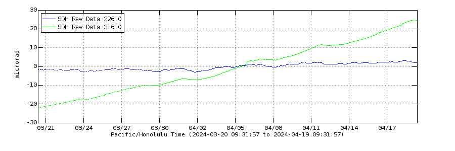 ?fileTS=1742805175
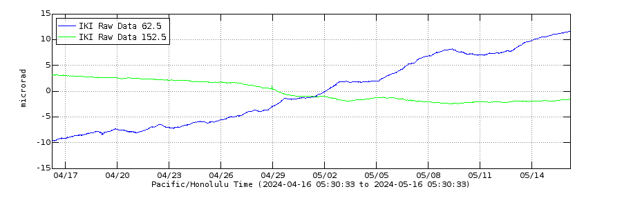 ?fileTS=1742805284
It looks as if the “inflation eruption” begins soon. The steam is already bright illuminated: https://www.youtube.com/watch?v=oG5zz9Sjw3E
Working on a Congo post( volcanic activity update )
Alaska on Mount Spurr:

https://avo.alaska.edu/image/view/196489
A bang looks very possible 2025. Would we get more sings before a VEI4 there, or can it happen any time?
As far I know this could be the first VEI4 2025 worldwide. Are other volcanoes in the competition for first VEI4?
Maybe Lewotobi?
HVO message 2025-03-22
The UWD tiltmeter malfunctioned on March 21. UWD was used to calculate likely windows of time for the next episode to begin. Data from SDH is now being used with an Adjusted model.
Mac
Increasing earthquake numbers at Svartsengi this morning. Time to watch the webcam: https://www.youtube.com/watch?v=8bfcTBLvPiM
Blank.
Try again?
Most webcams are offline now, only Þorbjörn is still working: https://www.youtube.com/watch?v=Bqudj0x0POA
Bad view. I hope that the eruption waits until a good webcam is working again.
Why?
And why did you link to one that was offline?
I’m wondering if Svartsengi is stalled. The dike is in place, pressured, but not enough deep input and energy to make the final push. Perhaps this is it for now, and it will quietly fade and cool.
Patience. It’s much to soon to say that. Quake activity is increasing. GPS trajectories continue to show inflation. It’s just slower. Last eruption started earlier than expected, so maybe it’s compensating now by waiting a bit longer.
Thanks. I’ll wait patiently!
Writing my Congo post…