A repost on the region of Lassen Peak in California, originally written by Henrik in 2013

Fig 1. The Milky Way over Lake Manzanita with the Chaos Crags, Lassen Peak and Brokeoff Mountain in the background (Wally Pacholka, astropics.org)
This article began as a regular piece on Lassen Peak but quickly expanded as I discovered how complex the geology and history of the Lassen Volcanic Complex was. Unlike nearby Shasta, Lassen Peak is but a dacite lava dome, one of the largest lava domes on Earth but only one of the dozens of lava domes and peaks to be found within the Lassen Volcanic National Park. Before we begin to unravel the very complex history of eruptions, collapses and glacial erosion, it is a good idea to acquaint ourselves with the area and its main features:

Fig 2. Major features of the Lassen Volcanic Complex. The most important ones are Brokeoff Mountain, the major remnant of ancestral Mount Tehama, Lassen Peak itself and the Chaos Crags. Please note the extent of volcanic features within the Park. (USGS)
Volcanic activity in the area goes back at least three million years. About 600,000 years ago, contemporary with the formation of nearby Mount Shasta, a series of large eruptions formed a huge volcano, Mount Tehama. Just to put it into perspective, the largest of these eruptions was about 50 times as powerful as the 1980 eruption of Mount St Helens or five times that of Mount Pinatubo. Mount Tehama was immense. At its base, it measured 18 km (11 miles) by 24 km (15 miles) wide and it stood more than 3,353 m (11,000 feet) tall. Its total volume must have been well in excess of 400 kubic kilometres, a rough calculation yields a volume of 425 cu km, comfortably larger than either present-day Mount Shasta or Mount Hood, both of which have volumes of about 350 cubic kilometres.

Fig 3. Brokeoff Mountain, a sad remnant of what was once the largest of the Cascade volcanoes. (Sing H. Lin, shltrip.com)
Activity at Mount Tehama continued for about 200,000 years and consisted mostly of pyroclastics and andesitic lava flows containing olivine. During the same period of time, other volcanic vents began to appear such as the shield volcanoes Raker Peak, Red Mountain, Prospect Peak and Mount Harkness. The distances from the central volcano, never more than eight miles, argues that they were satellite cones of Mount Tehama. As for the central volcano itself, there was a final, large lava flow on the north-eastern flank consisting of glassy dacite and further dacite flows formed smaller cones such as Mount Conard and Diamond Peak on the flanks of Mount Tehama.

Fig 4. Diamond Peak, a dacitic satellite cone of Mount Tehama. (vibadirect.com)
Subsequent glaciation combined with extensive hydrothermal activity led to major erosion and to a subsequent collapse of Mount Tehama of which today the only visible, large remnant is Brokeoff Volcano, also known as Brokeoff Mountain. The collapse structure, a caldera about 3 km (2 miles) in diameter, was quickly infilled by debris and material from later eruptions. Further activity built more than thirty other cones which are sometimes referred to as the Lassen Domes.
As we have already seen, Mount Tehama began life as a rather typical andesitic stratovolcano, but subsequent activity became more and more silicic. After its collapse and disappearance, local volcanism shifted to what had been its northern flank. The last 400,000 years have seen at least three known lava flows, parts of which can be seen on or near Raker Peak and Mount Conard. There is also evidence of a very large explosive eruption which ejected an estimated 50 km3 (12 cubic miles) of material and created a large crater which was soon obliterated by subsequent lava flows and emplacements. During this period, a further twelve lava domes were emplaced throughout the Park area. The next period of eruptive activity spanned some 50,000 years and ejected between 15 to 25 km3 (3.5 to 6 cubic miles) in the form of pyroclastic flows, viscous lava flows and mainly dacitic lava domes.

Fig 5. Lassen Peak showing the cirque gouged out by the period of glaciation from 25 to 18 kA. It also shows the area devastated by lahars and the 1915 major eruption. (Wikimedia Commons)
About 27,000 years ago,Lassen Peak started to form as a mound-shaped dacite lava dome pushed its way through the shattered north-eastern flank of Mount Tehama. As the lava dome grew, it shattered overlaying rock, which formed a collar of angular talus around the steep-sided volcanic dome. Lassen Peak reached its present dimensions of nearly two km across at the base and prominence of 606 metres above the surrounding landscape in a remarkably short time, probably in just a few years or at most tens of years.
From 25,000 to 18,000 years ago, during the last glacial period of the current Ice Age, the shape of Lassen Peak was significantly modified by glacial erosion. The bowl-shaped depression – cirque – on the volcano’s north-eastern flank is the result of erosion by a glacier that extended some 11 km (7 miles) from the dome.
To inject a piece of human history, Lassen Peak was named after the Danish blacksmith Peter Lassen (most likely an Americanisation of Larsen), who guided immigrants in covered wagons past this peak into the Sacramento Valley during the 1830s. The trail that Lassen blazed never found general long-term use because it was considered to be unsafe.

Fig 6. A beautiful sunset view with reflection of the pink Chaos Crags in the still waters of Lake Manzanita. The Chaos Crags, a series of five dacite lava domes, were extruded as recently as 1,100 to 1,000 years ago. (Sing H. Lin, shltrip.com)
Just over 1,000 years ago, a major period of activity resulted in the extrusion of five dacite lava domes that form the 177 metres high Chaos Crags. Initially, they must have been considerably higher as a major rockslide occurred just 300 years ago. Riding on a cushion of compressed air, the sturzstrom landslide travelled 20 to 30 times the vertical fall height and resulted in the formation of beautiful Lake Manzanita, 3 km (2 miles) from the Chaos Crags.
The most recent period of activity at Lassen Peak took place between 1914 and 1921. After 27,000 years of dormancy, Lassen Peak was shaken by a steam explosion on May 30th, 1914. By mid-May 1915, more than 180 steam explosions had gouged out a 300 metre-wide (1,000 ft) crater near the summit. On the evening of May 14th, 1915 the character of the eruption changed dramatically as incandescent blocks of lava could be seen bouncing down the flanks of Lassen Peak from as far away as the town of Manton, 30 km to the west. Next morning, the crater had been filled by a rapidly growing dacite lava dome.
Late in the evening of May 19th, the lava dome was fragmented by a large hydrothermal explosion. Glowing blocks of lava fell on the summit and snow-covered upper flanks of Lassen Peak and launched an 800 metre (half mile) wide avalanche of snow and volcanic rocks that roared 10 km (6 miles) down the volcano’s steep northeast flank, over a low ridge at Emigrant Pass and into Hat Creek. The lahar was deflected north-westward at Emigrant Pass and flowed more than 11 kilometres (7 miles) down Lost Creek. During the night of May 19–20th, dacite lava slightly less viscous than that which erupted on the night of May 14–15th, welled up into and filled the new crater at Lassen’s summit, spilled over low spots on its rim, and flowed 300 metres (1,000 ft) down the steep west and northeast flanks of the volcano.

Fig 7. This view of the climactic eruption of May 22nd, 1915, was taken from Anderson, California, more than 33 km (20 miles) from the volcano. (smate.wwu.edu)
At 4:30 p.m. on May 22nd 1915, Lassen Peak exploded after two quiet days in what is referred to as “the Great Explosion”. The eruption column rose more than 10,000 metres (30,000 ft) and was visible from as far away as the Pacific coast 240 km (150 mi) to the west.
The blast created the larger and deeper of the two craters seen near the summit of the volcano today. Pyroclastic flows devastated an area of 8 km2 (3 sq miles) below the volcano, and melting snow created a series of lahars that rushed nearly 16 km (10 miles) down “Lost Creek” to the Old Station. The lahars released large masses of water that flooded the lower Hat Creek Valley a second time. A layer of volcanic ash and pumice was traceable for 25 miles (40 km) to the northeast and fine particles of ash rained down as far away as 320 km (200 mi) to the east.
For several years after the main eruption, rainfall triggered steam explosions indicative of fresh lava just below the surface, and in May 1917, a series of vigorous hydrothermal explosions obliterated the two older craters and dug out the second of the two summit craters visible today. It was not until 1921 that the eruptive period was officially declared over.

Fig 8. The sulphur and mud springs of Bumpass Hell located near to what was the central vent of Mount Tehama. (Sing H. Lin, shltrip.com)
Mount Tehama today. Activity at the Lassen Volcanic complex is far from over. There are several areas of hot springs and fumaroles of which the Sulphur Works and the hot mud springs at Bumpass Hell on the Lassen trail are the most well known. With major eruptive activities during the Holocene, the area around Mount Lassen, which more accurately ought to be referred to as Mount Tehama, and the nearby Mount Shasta are considered to be the most likely volcanoes in the Cascade Range to erupt during the coming decades and centuries. Should they do so during our lifetimes, it is not inconceivable that we might see a repeat of the rapid growth of Mount Shastina, Lassen Peak or the Chaos Crags. I for one would much rather see this volcanic creation process than a truly huge eruption that has a “human impact”, to put it euphemistically…
Henrik
Lassen Peak is described in more detail in another post


I enjoyed reading that again! Thanks! It’s so easy to forget these ‘old’ places can still blow up.
A great study and work by Hendrik!
Mount Lassen was probably the rule of the US volcanoes between Canada and Baja California, while St. Helens was (and is) a hyperactive exception. St. Helens does frequent eruptions, but is not representative for the usual volcanoes. We humans (outside science) tend to think that what we experience is the rule of volcanoes. We forget that before our lifetimes there happened things (f.e. Mount Rainier’s eruptions during 19th century) that in some cases are more regular than the time of our personal historical experience.
Looking at the B1 camera, it seems Ep. 29 sent most of the lava to the east, filling up that low point and burying the September 2023 vents more. Next episode (depending on style of eruption) might almost be the last time to see these vents fully.
Also, it seems almost everything is in Italics…
Now everything’s back to normal.
The italics have been re-romanized
Kilauea as expected resuming inflation immediately, although after falling nearly 20 microradians and the last episode going past the pressure threshold, its pretty likely to be closer to 3 weeks for E30. But the epispdes do really seem to be trending larger with longer intervals and higher volume and intensity
The east direction of lava flows have filled the caldera fast. The base of the cone has risen a lot:
https://www.youtube.com/watch?v=oG5zz9Sjw3E
If the next episode 30 adds a similar thick layer of lava, the lava field will reach to the crater of the cone. In this case the cone has to grow with the lava shield.
The video shows the best moments of episode 29:
A comparison of UWE and OUTL GPS shows that OUTL is deflating over 2025, while UWE is slowly inflating (if we count the inflation maxima):
OUTL is above the SC magma chamber, while UWE more above H magma chamber. Does this indicate that magma is slowly moving into the shallow magma chamber? If yes, then it would mean that a sustained eruption becomes possible again in near future.
It means indeed that magma is rising into the shallow chamber, but that it is not being replenished at the same rate. The deeper magma chamber is acting as the main feeder for the eruption and is losing volume. The higher chamber is probably around neutral while the lava being deposited in the caldera is adding volume at the top.
S2 cam has a good perspective on the cone and shows that it is only 10-20m above the lava shield. There is a visible opening, which will probably work as an exit for lava during episode 30:
If the lava shield manages to grow above the present cone, the eruption style will probably change. Maybe the cone will turn into a hole in the ground like the Halema’uma’u hole 2008-2018.
Since the Cascades seem to be a bit of a theme, how about Three Sisters?
It seems pretty clear that they are not particularly close to doing anything, but I find the slow, persistent inflation to be intriguing.
Fascinating analysis of a region I don’t see discussed much (if I knew what I was doing, I’d pitch in!):
https://rdcu.be/exifh
The extinct Oe-Takayama volcano is responsible for a massive silver mining operation, which is now a World Heritage Site.
As I’ve mentioned before, the Abu monogenetic field recently had a multi-month seismic swarm, reminding us that it’s not dead. Sanbe, while perfectly content to rest, is considered active and still emits gases and warms hot springs at its foot.
And then there’s Daisen, which as I’ve alluded to, I’m not convinced shouldn’t be more closely monitored (late-Pleistocene to possible Holocene activity, low-velocity zones have been identified, it’s near multiple population centers, and multiple nuclear power plants lie in areas of known tephra fall).
Iceland: A cone has won the volcano monopoly and is erupting alone now: https://www.ruv.is/frettir/innlent/2025-07-22-hrauntjarnir-hafa-ekki-myndast-449162
The eruption is going on for six days now. Lava runs predominantly east towards Fagradalsfjall. Without the Pleistocene fjell, the lavas of Fagradalsfjall 2021-2023 and Svartsengi would meet now!
Steinunn Helgadóttir says “Activity is very constant … lava runs east towards Fagradalsfjall”
Live-video (linked by Jesper in the comments of the previous VC article): https://www.youtube.com/watch?app=desktop&v=Pi8wg2QYZbU
Earthquakes Iceland:
– Bardarbunga several shallow ones
– Torfajökull a small swarm on the northern caldera rim
– Ljosufjöll continues
– An earthquake path is visible from Keilir to Krysuvik – is Krysuvik going to join the Svartsengi Fires?
https://www.youtube.com/watch?v=nnlKEWhaps0
Isak is flying with his drone
Finally IMO published a map. Maps tell more than many words:
The lava floods the base of the fjell of Fagradalsfjall. Without this Pleistocene fjell, the lava from Geldingadalir would have had a great chance to reach the same area 2021.
I have a feeling this lava field is gonna be a thick one, volume might end up being around 30million m³ but on what seems to be a smaller area. Regarding fagra meeting svarts, i still havent given up hope for another true shield building eruption in fagra xd
Yes, it’s a flat area there. Lava is stored there without running anywhere else. It has this with Holohraun in common, where lava stayed more or less in the flat Icelandic highland:
I think that we can distinguish between the Svartsengi 1a eruption and the 1b eruption.
November 2023 to March 2025 was the 1a eruption with seven episodes based on the sill that intruded in November 2024.
On 1st April 2025 a new sill/dike intruded in the northeastern part of Svartsengi and initiated a 1b series of two episodes until now. The 1b series is more close to the Fagradalsfjall and Krysuvik systems. Therefore the GPS stations there showed more movements during the current episode.
How warm woud Earth be if it was placed at Venus Orbit? woud we end up rather quickly with a moist greenhouse that turns into a hell, or woud we end up with hot humid rainforested Earth thats still livable? planetary habitability depends on a whole varierty of numerous factors it haves not just to do with a simple orbit distance
This seems to have escaped the attention of people. Erta Ale has just had a major eruption and dike. Data in my posts below for your viewing.
https://x.com/Jbean451/status/1947676011908272202
https://x.com/Jbean451/status/1947677675692429687
https://x.com/Jbean451/status/1947707401110483133
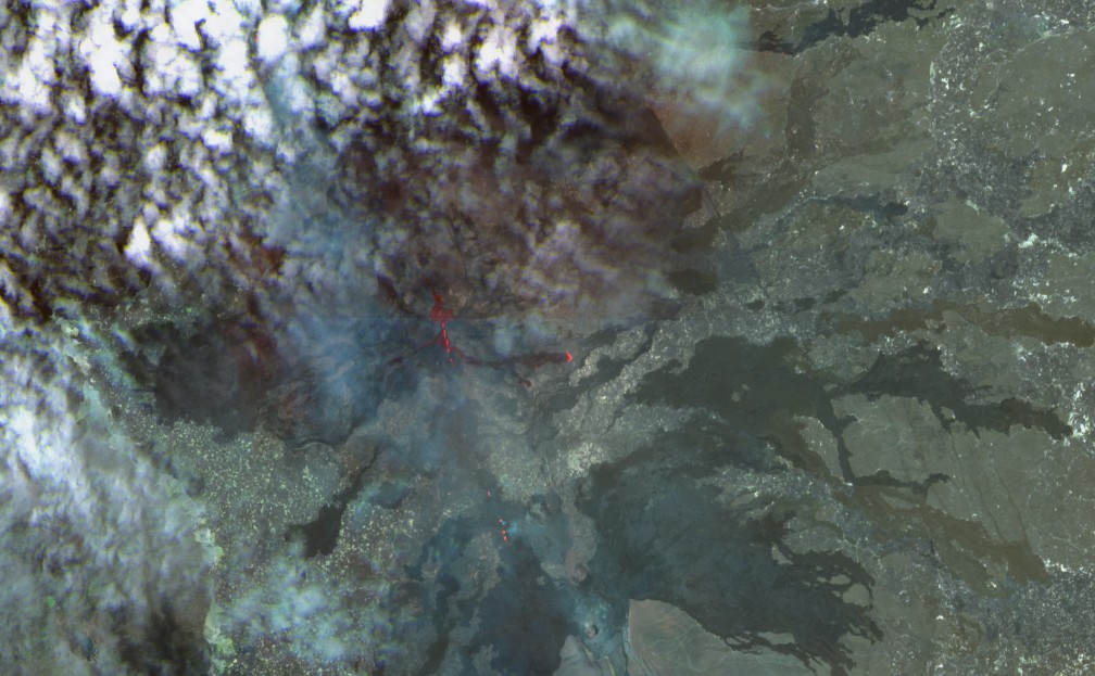
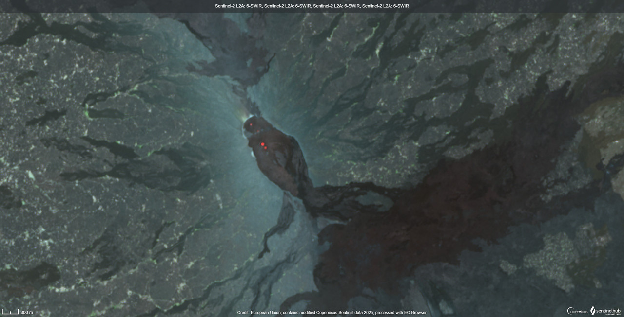
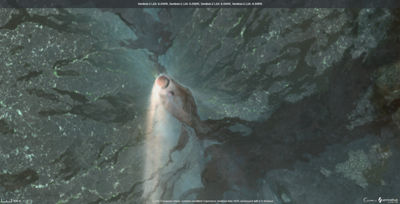
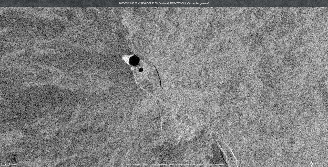
Here’s some satellite imagery of the eruption itself. https://x.com/Jbean451/status/1947708681400844512
I am afraid these links return the message that they don’t exist
That’s odd. I will just embed them here then. Sentinel 2:
Sentinel 1:
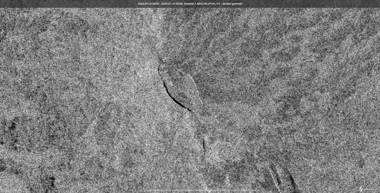
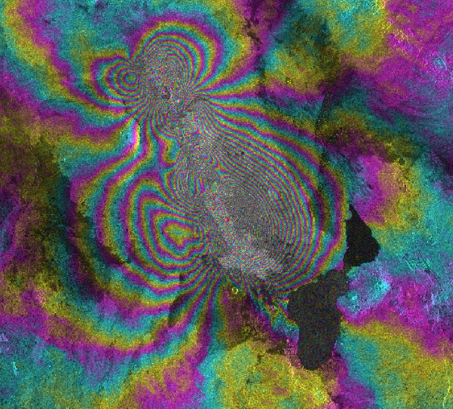
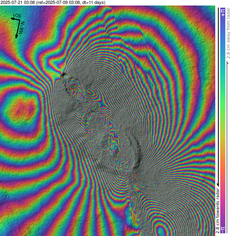
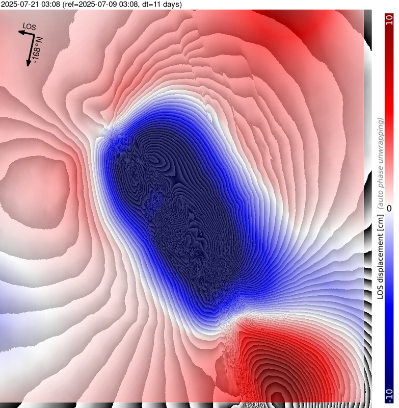
insar I made (it’s a 30-40km dike):
Thanks! A nice insar pattern. Note the reversal in the order of the colours in the two halves of the dike.
Perhaps your firstlink requires the reader to have a twitter account?
Looks like the dike might have even reach the dry lake bed, if all the magma flow keeps feeding it vents could emerge all the way down, which would be interesting and maybe also more accessable, its a hostile environment but the lake has an industry of salt mining. Probably going to be videis of it soon enough if this happens.
Either that or the neighbiring southern volcano has rifted too which changes things. I wonder if this is a wider local tectonic pattern related to the same cause of rifting at Fentale? Not direct cause but common strain between the plates?
In the first photo, you can see three fissure segments.
Here’s a closer look.
I posted a link but it was at the same time Kilauea took off and got drowned.
The eruption isnt that big though, a long fissure but unless the Sentinel data was very early it isnt a big lava flood. Erta Ale isnt really big enough to have the mass or shallow magma volume to do eruptions of significant intensity at least how it is now. Its definitely a classic shield volcano, just a hole in the ground that leaks.
Given there havent been any more high eat emission values, its probably turned into another leaky flank vent like it did 8 years ago, which might form some long lava flows and a small flank shield, but slowly over years. Lava might end up flowing into the salt lake flat to the south though which would be interesting.
The dike is extremely long for Erta Ale. The longest I know of from Erta Ale and it rivals dikes that lead to caldera-forming eruptions at other volcanoes.
This data is amazing jbean! Many thanks! So the ash seen some days ago did come from a collapse. Looks like both the north and south calderas are quickly deflating, the dike is gigantic with two segments, one shallower between Erta Ale and Hayli Gubbi, and one deeper starting from Hayli Gubbi southward, also the two volcanoes seem to be connected, or at least feed into the same dike. This same behaviour of multiple volcanoes feeding into the same dike was seen during the Afar rifting in 2005 which involved Dabbahu, Gabho, and Ado Ale (Manda Hararo) volcanoes.
So, I haven’t finished the Afar articles I was planning yet, but I have a fair idea of Erta Ale’s eruption style and history. Erta has never produced something like Holuhraun or even remotely close to it; its eruptions are mostly slow sustained effusion from vents along its two rifts. Sort of like Pu’u’o’o but without fountains, always degassed, presumably because there is always a lava lake/pond at the summit that keeps the system degassed. These eruptions have been very frequent lately, though the volcano saw little activity in the early-middle Holocene (the volcano mostly dates to around 25,000-15,000 years ago or so, like Hayli Gubbi, and older than Bora Ale and Alu-Dalafilla). 500-1000 years ago, the volcano was almost entirely resurfaced by lavas that came mostly from the rifts. Long-lived shield eruptions also continued to happen at intervals throughout the last 500 years resurfacing small portions of the volcano in a manner similar to the 2017-18 lava flow.
Yet the caldera of Erta Ale has collapsed before, which must have been from dikes like this one. The most singular event is a lava flow that is seen all around the southern caldera of Erta Ale, from an incredibly intense effusive eruption (unusual in the extent and total coverage of sheet pahoehoe lava around the rim). It’s not very voluminous. I think it was a sort of degassed basaltic ignimbrite associated to the collapse or partial collapse of the southern caldera. The caldera started to collapse due to a rifting (maybe like the current), then a ring dike intruded and lava gushed from all along the interior of the collapsed caldera, quickly engulfing the area around the caldera in lava. There are other options too, though, like maybe a huge ponded lava lake inside the northern caldera that at least once broke out from the south caldera floor in a Nyiragongo style, but I don’t think this explains how every inch around the southern caldera rim is draped in sheet pahoehoe.
If you need any more imagery or a timeline, I can help out. I’ve slowly been building one myself. The local conflicts and power outages in the area due to storms haven’t been helpful.
Thanks, I would certainly enjoy an update on how the caldera is doing when Sentinel satellites return.
I didn’t realise the main Lassen Peak dome complex had been dormant for 27,000 years before the 1915 eruption.
There are many volcanic locations in USA-48/Canada/Alaska that were dormant for many centuries or millenia, but can erupt again. The “Craters of the Moon” … on earth are an example for dormant periods of ~2,000 years: https://www.usgs.gov/volcanoes/craters-of-the-moon-volcanic-field
According to Wikipedia the Craters of the Moon are the largest Holocene basaltic lava field in the USA-48. They do curtain of fires like Svartsengi and Mauna Loa. But during an eruption the magma becomes more silicic.
https://www.nps.gov/crmo/learn/nature/volcanoes.htm
It’s the >10,000 yr dormancy that surprised me. A few hundred or a few millenia is one thing but that’s long enough to wind up with an erroneous “extinct” label had not the Chaos Crags and 1915 eruptions happened.
That’s interesting: the current Iceland eruption looked like it died between 13:30 and 19:00 today on the Fagridalur still camera photos; but it restarted again. And the SENG GPS is showing some rather inconsistent activity.
Interesting, maybe it doesnt have much longer left then, but then the fact it restarted is curious and might hint at a very open system feeding it. The fountain is lower but got pretty tall shortly after resuming.
I guess theres also a change it becomes a lava geyser like in 2021, or more truely episodic and paroxysmal like Kilauea and Etna. That would be exiting, although if it goes for the second option the long fast flows might reach the north coast and the road. Not to mention such an eruption would very likely turn into a shield volcano and then all bets are off as to what might be at risk long term. Grindavik would most likely be safe though, as well as Svartsengi itself, which actually seems to be the bigger concern from what I understand.
The vent is still breached and fountaining too, even a week later, which is curious. If the sill isnt deflating then the supply must be flowing through from deep down, which is a much larger source. Sundhnjukur isnt typical to do shield eruptions but who knows.
On the topic of what Erta Ale has just done, its interesting how many of these sort of tens of kms long dikes and rifting events have happened in the last 15 years. Holuhraun in 2014-15, Kilauea in 2018 (technically the dike there started small but it moved the whole volcano so counts), Ambrym in 2018, Fagradalsfjall in 2021 and possibly ongoing, Nyiragongo in 2021, Mauna Loa in 2022, Sunshnjukur in 2023 and 11 times since… Fentale in 2024 possibly ongoing, Santorini in 2025, and now Erta Ale and possibly Hayli Gubbi as we speak, and which looks set to have further eruptions.
In addition, Nyamuragira, Puyehue-Cordon Caulle, and Tolbachik in 2012, and Sierra Negra in 2018, werent long dikes but were still major eruptions and intrusions away from the center of their parent volcano. I am also quite probably missing a few more examples too.
In the entire decade of 2000-2010 I can only think of the rifting at Manda Hararo and Harrat Lunayyir, as notable eruptive intrusions. And the 90s I cant think of any examples at all really…
I say eruptive, meaning they could have erupted and in most cases did. The intrusion could intersect the surface. Deep intrusions are plutonic and dont count here.
I guess part of this might be recent event bias but still, it seems like especially since 2015 there have been a lot of volcanoes doing this.
There’s another one, Taal in 2020, a 0.5 km3 dike which is quite spectacular. We seem to have entered the decade of the rifting volcanoes…
The 2000s did have the Nyiragongo 2002 event, which had a massive dike that extended under Lake Kivu, I think comparable to the 2021 event. And in 2007, there was a sizable dike under Ol Doinyo Gelai volcano. Though neither were as large as the Manda Hararo, Holuhraun, Fentale, or current Erta Ale intrusions.
Is Taal able to do a large eruption during the current eruption/unrest period?
Rifting north of the volcano in 1749 was followed by a massive eruption in 1754, while rifting in 1911 was not followed by additional activity. Any of the two scenarios could be.
Wasn’t there an article on Volcanocafé that predicted a series of eruptions on Taal beginning 2020? I remember to have read an prediction in an article here. I’ve searched for it, but haven’t found the correct one.
I think so, not sure which, but I do remember the reasoning that because past eruptions came in clusters, the 2020 eruption would mark the start of a cluster (which has proved correct).
Yes I forgot about Taal, which has stayed pretty active ever since. Frequent small explosions in its lake. If it was a dry volcano it might have an open glowing vent or even a small lava lake, but the water quenches it.
Its a bit unclear if Taal is going to do anything else though, its going to take a long time to refill 0.5 km3, it isnt sitting on a patch of extra productive mantle to fast charge it like most of the prominent volcanoes on this list, but then it also seems unlikely to stop soon too.
It has been an active decade for eruptions. Long dikes are expected in rifting environments. I guess Kilauea counts because the sliding down of the mountain acts as rifting. But we are also much better at detecting them thanks to the insar satellites.
But still, the frequency of events recently is clear, I mean since 2020 there have been 8, and even counting only dikes over 30 km, which is huge, there have been 3, in 5 years…
I remember back during Holuhraun, as a new lurker here, and how major of an event that was, the biggest eruption in Iceland in 230 years and also the 5th biggest eruption there people have observed full stop, a historic event for sure. And then Kilauea bested it on equal terms less than 3 years later… 🙂 And 8 more rifts since then too.
Whats the source for kilauea besting Holuhraun in 2018? Holuhraun seems to have been confidently estimated at 1.2km³ DRE, while the LERZ 2018 event seems to be more ambiguous due to ocean entry. Poland et al used an estimate range of 0.9 to 1.4km³, but the most common estimate i find in papers is ~1.1km³. One paper calculated the lava volume within water to be 0.7km³ with the volume on land being less than half of that. Holuhrauns average flowrate over its 6 months duration was 90m³/s. To me both appear basically the same in terms of erupted volume (within error). If we talk about collapse volume then Barda no-diffs
Eruption intensity, Holuhraun was 6 months, stronger to start but never anything insane, a lot of the Sundhnjukur fissures were much stronger in all metrics except duration.
In comparison Kilauea erupted on the lower ERZ for 5 months, but in reality it was 90% in about 7 weeks, and the peak rates in the surges were about as high as the opening curtain of fire from Holuhraun, but from a single vent. The volume on land is about 0.4 km3, mostly in the fissure 8 lava delta, and offshore 0.7 km3. But given that lava delta didnt exist until June 2018 and stopped in early August, it is 2 months max to erupt at least 1 km3 of lava, which is about 200 m3/s.
https://pubs.usgs.gov/publication/70219197
This gives the volume basically a 50% chance of being conclusively bigger in DRE, from what I have seen otherwise it seems the larger end of that is more likely too with newer data. So it may or may not be absolutely bigger, it was certainly much more intense.
It also has to be mentioned again, how crazy it is that it is very likely that the entire 2018 collapse scar at Kilauea, will probably be filled in completely by its 10th birthday…
The satellite, internet and computer methods allow to observe events in the world that were underreported before. So I’d assume that rifting hasn’t increased, but the ability to get news about rifting events.
However on Iceland there are decades with rifting, and then a long time no rifting (f.e. Askjs 1920s, Krafla 1970s, Fagra/Svartsengi since 2020).
Also, Fani Maoré off Mayotte, 2018 and possibly continuing.
Nyamuragira must still have its overflowing lava lake at the moment too, frequent heat signatures of 0.5 up to nearly 5 GW pretty much all the time. Nyiragongo is pretty cold though, not dead but it clearly isnt as active as before. They dont share magma but they do share heat so maybe Nyamuragira is just more open now
The higher figures are probably when the lake is foundering. It is known that there is not only a rea lake there but also a rootless lava lake adjacent in the old crater, which might have an active surface too, and that is a huge surface area. Kilaueas last episode had a peak emission of about 3x the recent high of Nyanuragira, and covered about 3 km2 of ground in new lava. So maybe the area of Nyamuragiras lava lakes combined is up to 1 km2, which is enormous. Most of that isnt convecting but still…
I wonder if Nyamuragira is capable of rifting properly. In theory is us in tbe right setting, but it hasnt got any obvious rift zones. It may be a very infrequent evebt. But it also has a caldera somehow and it didnt blow up to create it… Unlike most of these other places I wouldnt put it past the 2nd most productive shield volcano on the planet to do a major (over 1 km3) lavaflood eruption if it did rift. Nyiragongo gets the attention but this might be just as catastrophic. Maybe it is even what triggers limnic eruptions in lake Kivu.
I guess for now it is peaceful, even if maybe the area isnt geopolitically.
Despite Nyamuragira being overflowing, it has been very sporadic at it, so I’m not sure it’s particularly active right now. Nyamuragira’s incredible productivity in past decades has come from producing Mauna Loa-sized fissure eruptions at intervals of only a few years.
Regarding rifting, I’m not sure if it’s capable of it or not; probably it can, but overall it seems like a “radial” volcano that uses inclined sheet intrusions to erupt, like Piton de la Fournaise or the Galapagos volcanoes, but while possibly lacking a large shallow chamber.
Never seen this before: climate classification for the worlds oceans! I guess that over the oceans that stores and releases wast ammounts of heat and energy due to waters high heat capacity, that means that winter and summer variations over Earths oceans compared to the land areas maybe a more or less non – existent affair in ways of temperatures seasonal differnces. The ocean areas just south of Iceland are certainly not any tundra climate quite warm all year around for latitudes
Link https://www.reddit.com/r/geography/comments/1j1u0z7/climate_zones_over_the_oceans_is_humid_climate_on/
Without the Gulf Stream the North Sea would be as cold as Hudson Bay with ice in classical winters (before recent climate warming). Iceland is on a latitude where it without the Gulfstream would be surrounded by ice in winter.
The northern Svartsengi eruption is slowly dieing now. Volume is “26,8 millioner kubikkmeter”, area “3,3 kvadratkilometer”. The average rate of the eruption is estimated 12 cubic meters per second.
https://www.vedur.is/um-vi/frettir/kvikuhlaup-er-hafid-a-sundhnuksgigarodinni
Volumen : 26,8 m/3 !
The eruption continues with zero deformation. Maybe it erupts exactly the amount of magma what it receives now. It’s become a tourist eruption, but will probably end before you can get there.
https://m.youtube.com/watch?v=1TDfIdUy7Qw&pp=0gcJCfwAo7VqN5tD
Isak is flying again
Haven’t seen it mentioned but Erta Ale is believed to have collapsed by around 250 metres causing some minor explosive activity, whilst pushing a dike some 30-40 miles (!) southeast.
Unfortunately there was a severe storm in the region so communications are limited at present.
We may well see some volcanic activity at Afdera given how the African rift volcanoes like to interact.
GeoglogyHub just posted a video about the Erta Ale situation, it looks as though the dike is getting close to a town and may even be under it at this point meaning the dike may be around 40km in length.
https://youtu.be/wrYs7nbNfxI?si=P_vf3PLLb5FcAjlG
Geologyhub on Erta Ale right now. If the reports are true then its not unlikely some lava will flow out down on the salt lake, if the dike is kept alive for a while.
Im not sure of his reasoning why there are two dikes at different depths though, either at Nyiragongo in 2021 or Erta Ale now. Im not really even sure there is an example of this ever happening anywhere in this manner.
Anyone got any ideas on why GFUM horizontal deformation completely reversed while the system is still inflating?
Near Paricutin there was a magma intrusion with swarm quakes below extinct Pico Tancitaro volcano. https://www.vulkane.net/blogmobil/
How frequently does the Michoacán–Guanajuato volcanic field, that hosts Paricutin, monogentic eruptions like this? Wikipedia only mentions the El Jorullo 1759-1774, but it seems likely that this volcanic field did more in the past. GVP lists nine events (one uncertain) during Holocene with up to VEI3.
New article is up. Another Ethiopian volcano joins the fray:
https://www.volcanocafe.org/erta-ale-erupts-and-produces-a-giant-dike-intrusion-could-the-caldera-collapse-is-there-more-to-come/
Pingback: Medicine Lake Volcano and Lava Beds National Monument | VolcanoCafe