Source: https://gearjunkie.com/travel/lassen-volcanic-national-park-visitor-guide
There is something about the west coast of the contiguous US. The region combines a wonderful climate with a high standard of living where the land is big, diverse and beautiful. It is a magnet for people, on par with Florida. But it has something which Florida lacks. Whilst Florida is a subtropical Caribbean paradise, the state is entirely volcanically inactive. In contrast, all three west coast states have volcanoes in full working order.
These active volcanoes are surprisingly equally distributed among the coastal states. Washington State has five: Mount Baker, Mount Rainier, Mount Adams, Glacier peak and Mount St Helens (the only holy one, and of course the one that erupted so famously). ‘Active’ here is defined as a volcano with active magma which could well erupt. Indeed, of the five, four have shown activity in the past 250 years!
Moving south, Oregon is a very different state but it has the same number of active volcanic systems: Mount Hood, Mount Jefferson, Newberry, Three Sisters (which I here count as one) and the bad one, Crater Lake. Mount Hood had an eruption less than 250 years ago: the others last erupted 1000 to 5000 years ago.
The unexpected winner is, though only just, California. It has 6 volcanoes which have erupted in the past 5000 years: Medicine Lake Volcano, nearby Mount Shasta, Lassen Volcanic Center, Long Valley Volcanic Region, Ubehebe Craters (did you know that one?), and Salton Buttes. (Clear Lake Volcanic Field is a 7th volcano which could erupt but it has been quiet for the past 10,000 years.)

Winning by numbers is not the same as winning by results. In terms of impact, of the six Californian volcanoes only Mount Shasta ranks among the 10 most dangerous volcanoes in the US. It last erupted around 1250 (not 1786 as some say, which was a grass fire). But number 11 on the list is also Californian: it is unassuming Lassen Peak which erupted as recent as the 20th century. USGS views it with caution for a reason.
Lassen Peak

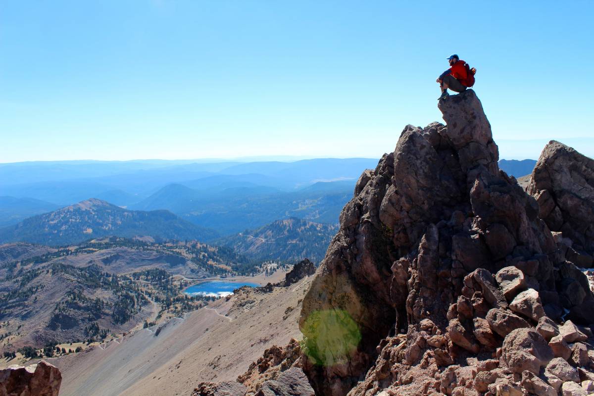
At the very end of the Cascades lies this shapely mountain, 3100 meter tall. The mountain looks barren brown – trees grow only at some distance from the peak. This emptiness is evidence of its activity. This is the location of the other Cascade eruption of the 20th century. Before St Helens, there was Lassen Peak.

The area is a national park which describes itself as ‘ home to steaming fumaroles, meadows freckled with wildflowers, clear mountain lakes, and numerous volcanoes. Jagged peaks tell the story of its eruptive past while hot water continues to shape the land.’ The description tells you that this area grew into a volcanic field rather than a single mountain. The land is deeply eroded by the ice age glaciers. (So much of the beauty of the natural world which we take for granted came from the Ice Age. How different our mountains were before the ice.) Hiking is the best way to see the Park: there are many well maintained trails, although not in winter when they can be covered under meters of snow and the park is closed. The fumaroles steam even better in the cold, though. They are fed by water from the snow melt, which percolates down to depth where magma is present. The heated water returns to the surface in hot springs and burping mud. The area is wild and diverse with buttes, cones, domes, lakes and sand. Much of the forest was sadly destroyed in the Dixie fire of 2021. Lassen peak is the largest of the domes, and according to wikipedia is among the largest plug dome volcanoes in the world.
Lassen peak formed in a brief phase where dacitic magma reached the surface and pushed out in a big dome, too viscous to flow far. For some reason to grew much larger than such volcanoes normally do. It happened within the space of a few years, some 27,000 years ago.
It is not the only volcano in the park. There are four extinct shield volcanoes, much older than Lassen Peak, and over 30 other volcanic peaks of varying ages – some very young.

Painted dunes, seen from Cinder Cone, formed from eruptions around 1650. Source: Wikipedia
The Park and the mountain are named after Don Pedro (Peter) Lassen, who in spite of his adopted name (the territory was Mexican at the time) was a Danish immigrant. He moved to California in 1840 where he worked as a traveling blacksmith and adventurer and later as a rancher. Lassen has left us a mixed legacy. One of his projects was the Lassen cut-off, an alternative to the final section of the California Trail along which people traveled to the state. He advertised it as shorter and better while in fact it was longer and worse and people who took it regretted it – some needed rescuing. Lassen started his cut-off around 1848 . It quickly became known as the death trail and was abandoned in 1853. The cut-off ended near his ranch – where he was ready to sell new supplies to the exhausted and desperate travelers, having made sure in the advertisement that those migrants would have carried minimal supplies for this ‘shorter’ route. (It was twice as long as he said it was.) A third of the gold rush ’49ers’ took this route. This was the era of the gold rush, and it is perhaps a sign of how the wild west brought out the worst in people. Lassen was murdered in 1859. It is not known who did the deed but there were plenty of potential suspects. This criminal fraudster was awarded with the naming rights for the area. Perhaps a reassessment would be in order? A more worthy name is that of Helen Brodt, the first woman to climb Lassen peak in 1864: Lake Helen is already named after her. But perhaps the native Americans have a name which has primacy and could be used. Tehama Park, perhaps? Any name would be better!
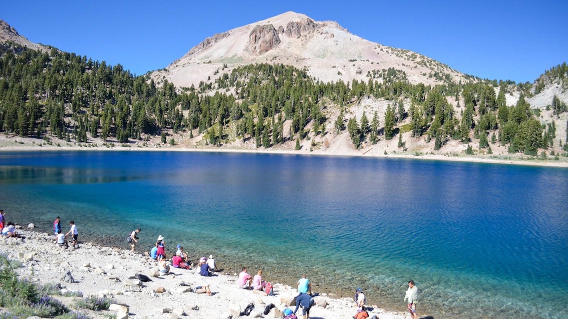
Lake Helen. Don’t be fooled: this is a glacial lake, frozen until well into June
The eastern half of the park is a volcanic plateau. There are some cinder cones here. The youngest is called in typical creative language, Cinder Cone: it formed from eruptions around 1650. Hot springs are found in the south and southwest. They sit at the location of an ancestral volcano, Mount Tehama which has long gone. The eruptions here have been mainly basaltic and andesite, but Lassen peak is made of dacite, a more evolved version. It formed 27,000 years ago as a dacitic dome. Other domes formed around it at various times, including Chaos Crags, 1100 years ago. The whole area remains at risk from eruptions, but also from more pedestrian hazards such as rock falls and mud flows. And of course, the main hazard are the tourists themselves who ignore barriers to explore where no one has gone before (and returned), and get badly burned when breaking through the thin soils into the hot springs below.
Formation
The presence of both shield volcanoes and dacitic domes shows that the region is complex. What they have in common is that the eruptions are mostly effusive rather than explosive. The shield volcanoes formed from basaltic eruptions: they are located along tectonic faults which allowed magma to reach the surface. The dacitic domes formed from more viscous magma which slowly pushes its way up and out, but has difficulty flowing far. Both avoid explosions because of a lack of gas. The cinder cones form the third type of eruptions here.
Volcanoes in the Park have come and gone. Tehama was around half a million years ago. It build up a shield a little larger than Lassen Peak is now. The mountain itself is gone, largely through erosion, but a variety of ridges remain. Route 89, providing access to the park, runs through the remnants of Tehama. After it died, the magma became more dacitic and a series of cones formed around the current area of Lassen peak. Now the four shield volcanoes grew. Over the past 50,000 years, there has been a variety of eruptions, some producing basalt, some going for dacite. The basaltic eruptions have filled in a NNW to SSE oriented graben which runs from Hat Creek Valley to Lake Almanor.

King’s Creek waterfall tumbling over the oldest lave flows. https://americantraveljournal.blogspot.com/2013/09/kings-creek-falls-lassen-volcanic.html
One phase of eruptions produced thick dacitic lava flows. These came from the region of the later Lassen Peak. The oldest flows are seen at King’s Creek: they have been dated to 38,000 years ago. Over some 10,000 years, the flows formed a small plateau some 400 meters high. The dacitic dome of Lassen peak formed on the plateau, probably within a very short space of time, perhaps as short as a few years.
Since that time, a series of smaller lava domes have formed around it, on average around 1 per 1000 years. The most recent of these are Chaos Crags: a series of 6 separate domes on the northern flank of Lassen peak. They are rough-looking, steep, and crumbly!

The domes of Chaos Crags, two of which have collapsed. Source: Wikipedia.
Cascade Range
The Lassen Peak Volcanic Field is at the southern end of the Cascades. The Cascades are the main belt of west-coast volcanoes stretching from northern California to Canada, sitting on the west side of the Rocky Mountains. Here are the Big Beasts of the West: Rainier, St Helens, Shasta. It is a long and rugged mountain range, with isolated volcanoes rising far above the other mountains. The range is young, as mountains go: these mountains began to grow around 7 million years ago, long after the Rockies.
The Cascade’s cause lies to the west, in the Pacific ocean where the Juan de Fuca plate is being extinguished. It is subducted – reluctantly – underneath the American continent. Only a small fragment of it is left. It has split up in three parts, separated by transform faults. The southern part, off the coast at Lassen Peak, is called the Gorda plate. But in effect this is still the same, dying plate. Different from most subduction zones, there is no trench along the coast. This is because the plate here is young and remains buoyant: It does not sink much while it is overridden by the continental plate.
Underneath the Cascadian range is a melt zone where the subducted plate releases its water, the water rises into the bit of mantle just above and lowers its melt temperature. Magma forms, begins to move upward, and shapes volcanoes. The magma also pushes up the land around it: it has lower density than the solid rock, and therefore the land above sits a little higher. Erosion now makes the texture of the land. This rising, eroded land becomes topped by the volcanoes. Some of the eruptions build up plateaus rather than mountains. It is all part of the mountain-building game, forever played by the Plates. This game gave us the US’ most impressive volcanoes – and it gave us the wild one, Lassen Peak. In 1914, Lassen was ready to show us its nature.
The 1914 eruption
After a long quiescence, a phreatic explosion on 30 May 1914 heralded the re-awakeing of Lassen Peak. The explosion came from the summit of Lassen peak. More such explosions followed. Over a year, some 180 explosions dug out a summit crater which finally grew to 350 meter across.

The May 22, 1915 eruption of Lassen Peak as seen from Red Bluff, California. Source: National Park Service
14 May 1915 was the day it went for it Lava reached the surface and was thrown out in the day’s explosions. The lava heralded the arrival of dacitic magma. As in an echo of the formation of the Lassen Peak 27,000 years before, a new dome formed on top of the old dome, starting inside the crater but quickly growing beyond it.
The next phreatic explosion occurred on 19 May. It blew the dacitic dome apart and covered the summit and flanks in the debris. Now the real event started. The steep, snow covered slopes were carrying the weight, and the still hot dacite block melted the snow. An avalanche of rocks and mud came down the northeast side and reached Hat Creek and Lost Creek Valley, 7 miles away. This was a lahar before lahars were known. The melt water flooded Hat Creek Valley.
The removal of the dome opened up the conduit for more fluid lava. It came down the flanks in short flows, up to 300 meters long.
For two days nothing happened. Then, on 22 May 1915, the mountain exploded again. What caused this is not known. Did something allow water to enter below the lava? Or had gas collected in the conduit, unable to pass through the cooling lava surface? This explosion was the largest one. It formed a crater which still exists. The eruption column was 10 km high. It was no St Helens, but it certainly attracted attention. A pyroclastic flow formed, following the same path as the lahar of 3 days before. It carried with it the mud and melt of the previous flow, entered Lost Creek and flooded Hat Creek – again. Light ash fell 300 kilometer away, blown with the wind. The area which was devastated by this flow is still called the Devastated Area.

https://pubs.usgs.gov/fs/1998/fs173-98/downloads/fs173-98.pdf
In a way, this was the end. In another way, it wasn’t. The lava was finished but the water was still there. The hot rocks continued to cause phreatic explosions especially during the snowmelt season. In May 1917, the largest of these carved out the second of the two current summit craters. Over time, the explosions lessened and finally ceased. In 1921, the phreatic season did not return. Steam would continue for decades, but the eruption was over.
There is a short film of one of the phreatic explosions of 1915, republished on youtube:
Why was the activity always in May? This shows the importance of water. May is when the thick snow (over 10 meters is possible!) begins to melt and turn the ground to mud. The phreatic explosions reacted to water coming from the melting snow. This volcano is driven by weather.
Chaos Crag
The 1914 eruption had come unexpectedly. Could we have seen it coming? With modern instrumentation, that is more than likely. But there had been other signs that the Lassen Peak area was not dead, such as the young-looking ejecta in the region. One of these was the Chaos Crags, on the northern flank of Lassen Peak. It was clearly a fairly recent eruption.
The Chaos Crags eruptions have been carbon dated from pyroclastic deposits. The age ranges of 1000 to 1100 years. It started with an explosive phase which deposited about 0.15 km3 of pumice and pyroclastic flows. The lava flows came later. The Crags themselves contain a little over 1 km3 of lava, which was erupted quickly. About 70 years later, one of the domes collapsed and exploded. Nothing more happened until 300 years ago, when a second dome collapsed. The collapse obliterated the area to the north: it is now called the Chaos Jumbles. The oldest trees growing around the Jumbles here are indeed 300 years old. The Chaos eruption was ten times larger than the 1914-1921 eruption. It shows what the area can do and why it is so high on the list of the most dangerous US volcanoes.
Cinder Cone

This double hill of loose scoria is more recent than Chaos Crag. (The older hill is almost entirely covered by the younger one.) The lava erupted into a lake a small part of the lake survived on either side of the hummocky lava flow: this flow is called, for unclear reasons, the Fantastic Lava Beds. (The naming in the area seems open to improvement!) The eruption was at first thought to date around 1850, but it was quickly realized that trees in the supposedly erupted area were 150-200 years old. This changed the date to around 1650. A tree ring record showed that there was a notably poor year for tree growth in 1666, and this is considered as one possible date for the eruption. Although there are several different lava flows and ash deposits, they were all erupted within a few months, as part of a single event.

Source: https://pubs.usgs.gov/fs/2000/fs023-00/
There is a story behind the eruption date of Cinder Cone. Some early explorers (around 1870) thought that the lava looked so fresh that it must have been erupted only decades before. In fact there had been reports of shooting lava and hot rocks from people traveling on the gold rush trail. Some reports were from the spring 1851 but were not reported until later. However, there is also an earlier report from the Daily Pacific News in San Fransisco of 21 August 1850, of an erupting volcano with “burning lava still running down the sides.” Other claims were dated to the winter of 1850. For a while this was taken as fact and attributed to Cinder Cone. Later it was realised that it could not be correct: from traveler reports, it was clear that the mountain had not changed before and after this year, and none reported any signs of an eruption. Even a tree growing near the summit was still there and was in good shape. Was Lassen involved in the story, getting in some advertisement for his trail? After all, an other alternative and competitor, the Nobles Trail, ran close to Cinder Cone. It is a guess, but it would fit with the character of the guy.
Mixing magma
The original magma of the Chaos eruption was rhyolite. This was mixed with a smaller amount of basaltic magma, with high aluminium content. The basaltic fraction increased during the eruptionL the first ejecta had very little, later ones had about 20%. The eruption came from a rhyolitic magma chamber which suffered a basaltic intrusion. At the time of mixing, the original magma was about 70% liquid and 30% crystalized.
Cinder cone also showed a changeable magma composition, although not as diverse as Chaos Crag. It started out as basaltic andesite, changed to andesite and ended up again as a basaltic andesite bit now with higher titanium.
The Lassen peak eruption showed four different types of lava, all erupted within the three days of the main phase: black dacitic lava, andesitic lava, banded lava with dark andesite and light dacite, and plain light dacite, which were erupted in this order. The andesitic lava formed inclusions in the black dacite: the inclusions ranged in size from a few millimeters to half a meter, and accounted for 5-10% of the lava. As in the other cases, there was a host magma (dacite) and an intrusion (andesite), where the magma was partly mixed and partly unmixed. The first lava formed the dome out of glassy black dacite. Some of it was apparently solidified lava which had been blocking the conduit. The lava that followed the dome explosion was again dacite. The banded and unbanded light dacite was erupted on the 22 May.

Four lava types from Lassen Peak. (a) black dacite; (b) light dacite; (c) banded pumiced; (d) andesite (erupted together with included in the black dacite). Source: https://academic.oup.com/petrology/article/40/1/105/1571435
The intrusions varied between eruptions. Chaos Crags contained the most mafic of the lavas erupted in this period, the other intrusions were more evolved. The intrusion was always hotter than the magma it intruded. This temperature contrast prevented mixing, and caused the new magma to form separate inclusions. Later the temperatures equalized and the magma types now formed a more homogenous mix. Perhaps the best way to visualize this is with a bread maker. Although I do not recommend pouring magma into one!
It seems clear that there is a significant reservoir of uneruptable old magma in the area, which can activates when an intrusion of hotter new magma mobilises it. How long this process takes we don’t know. Perhaps the next eruption will tell us.
Hazards
Based on past events, Chaos Crags has long been identified as the most dangerous part of the park. Eruptions give warning, but rock falls come suddenly. The Kazbek disaster has shown how dangerous these can be. Now add the risk of one of the domes collapsing completely, with the resulting rock avalanche reaching the tourist areas at extreme speed and without warning. This hasn’t happened for 300 years – but one in 300 is a significant risk. USGS monitors the Crags closely, looking for the early signs of movement.
Could there be another eruption? We have no idea. Was the 1914 eruption related to the one 1000 years ago? Is there a living magma chamber here, ready to receive an infusion of fresh basalt? The answer to that is probably yes. But that might also be the start of a tourist eruption. The contiguous US has never had one. I do hope they fix the names before it happens.
Albert, December 2022


Fuego is going again
https://www.bbc.co.uk/news/av/world-latin-america-63939229
The last volcanic eruption on the West Coast was in 1980. The last eruption of Lassen peak was early in the 20th century Florida’s most recent destructive hurricane was 10 weeks ago, and we have reason to expect another such event or more this year. I suppose you have a point there.
Last eruption was in 2007, for St Helens.
Ah yes! 2004-2008 dome building. Even better. But no Hurricane Ian….much to Sacristan’s dismay. At least…not yet,
Very interesting. Thanks much Albert.
The Clynne piece in the Journal of Petrology is nice. Looking at lava can reveal a lot about what happened down in the magma chamber. Pity the figures in the online JoP have such low resolution.
3D Lassen peak dacite.
https://sketchfab.com/3d-models/lassen-peak-dacite-8c3c93dcadf04870b5f7591b997bd9eb
Hmm, 3D is vague either… 😓 😖
James St.John has nice pictures of the porphyritic dacite from Lassen 1915 on Flickr showing the “quenched blobs” of andesite in Dacite.
https://www.flickr.com/photos/jsjgeology/23723993418/in/photostream/
Myers & Loomis. The Great Eruption of Lassen Peak – May 22 – 1915. Taken at Anderson, 50 Miles. University of California, Davis. General Library. Dept. of Special Collections, 1936. digital.ucdavis.edu, https://digital.ucdavis.edu/collection/eastman/D-051/B-2/B-264a.
Weird photo .. looks clipped in the eruption cloud .. perhaps it is too for some purpose
thank you Albert. I always enjoy reading your articles both for my favorite subject and your writing style.
That said.. I currently find myself on Azores and puzzled more than ever. I also know it is one of the most favorite places for Jesper. And there is so much to see. First time going down volcanic vent at Algar do Carvao.
So far on island Terceira, it seems all calm and quiet. The island is formed by 4 calderas, largest one being Cinco Picos, 270ka or so, and solid sized 7x9km. Unfortunately they don’t feel like sharing much more geo info (unlike Hawaii). Pico and Faial island are next for us, both with very recent volcanism. Is there any simpler info I can read about?
I have so many more questions – this is one of those day I regret not studying minerals and volcanoes.
We haven’t covered the Azores much, so far. So many volcanoes – so little time. Something to consider. We are always happy to receive contributions.. VH has quite a few (older) posts on the Azores which may be a good starting point. As an example, https://volcanohotspot.wordpress.com/2016/03/08/3-2-volcanoes-sao-miguel-island-azores/
Thank you. This is amazing. Now on Pico, seems they have an interpretive volcano house with earthquake simulator. They lack a volcano so far, as any sign of its shape is hidden in clouds.
I ll start there and come back with questions.
Azores is pretty and have pretty much the most comfortable climate on the planet, Oceanic Subtropical Climate. Souch weather only exist elsewhere in Madiera and Northen New Zeeland. It ranges from 17 to 24 C depending on season
Volcano wise its a very large area, althrough volcanism per square kilometers is weak to very weak, but there are so many submarine volcanoes and magma chambers that volcanoes erupt there on avarge 4 times every 100 years.
But the individual volcanoes on the Islands go many 100 s of years between eruptions. Azores volcanoes are quite alkaline and melting is low in the mantle there. But Pico volcano most of the upper cone is a very young construct, so must have been ”light house of the Atlantic” for a long time, with constant very slow pahoehoe effusion. But most of the central volcanoes in Azores are not very active
only 2 are currently marked as restless. Sao Jorge of course, and Santa Barbara in Terceira. A lot of eruptions are also under water.
The size of calderas makes me think there is more material produced here that just gets dumped into the ocean. But large part of changes in Azores seems to be just tectonic.
I’ve visited Lassen Volcanic National Park a few times already, but I never heard the story behind Don Pedro Lassen and his deceit of gold rush travellers. Either I missed that part of the story, or the visitor centre prefers not to include this bit of information in their brochures and signs. Always something new to learn, thanks!
The hike up to Lassen Peak is a quite a struggle with its loose scree and lack of shade. The first time we tried we ran out of water and turned around, parched by the sun and wind. But the views from up there are great.
Got to wonder what is the actual true frequency of all eruptions along the western half of the mainland US and Canada? There have been 3 eruptions in that area since 1900, and 2 from the same volcano. But there are hundreds of monogenetic cones like Cinder Cone, some of which are barely older than their historic discovery. Statistically we must be at least likely to see one show up in the 21st century…
Yes. We would be (un)lucky not to have a US west coast eruption this century. Exempting the afterbursts of St Helens, I think there is a higher than 50% chance of an eruption. It could be anywhere. Even the hinterland in New Mexico is not excluded.
It would be nice to know how many volcanoes have erupted in the past 1000 years, and the date of most recent eruption as well as of the prior eruption to get an idea of recurral times. I get the idea that these monogenetic eruptions could be not entirely random though, clustering a bit. At least at the Three Sisters this is true, between 3000 and 1500 years ago that place was one of the most productive sources of lava found in any subduction zone, more so than even the Klyuchevskoy group, but in the last 1500 years there has been only one eruption, and it was a small spatter cone and an explosion crater above a dike 1350 years ago… Not so sure about anywhere else but only St Helens seems to have somewhat regular eruptions in the Holocene and it is also the youngest of the Cascades stratovolcanoes which is probably why.
Statistically the next eruption is probably going to be from St Helens again, more lava domes. Out of anywhere else my best guess is at Long Valley, that area is inflating persistently now for 40 years and has many young eruptions as recent as the 19th century. 3rd place for me is Craters of the Moon, which has a roughly 2000-3000 year cycle, and going on 2500 years now. And that is going to be a big one, there are Laki sized Holocene lava flows of both tube fed pahoehoe and flood a’a. It is a polygenetic fissure, a Mauna Loa but without the Mauna 🙂
Rainier is the one that scares me. It just has a top-heavy look to it.
Shasta last erupted in the 1700s.
People I know in Oregon say Three Sisters is one to keep an eye on.
At least when 3Sis gets going, there’ll be plenty of warning (MSH gave a week, and two months until juvenile magma showed up.)
Rainier, a slope failure can occur at any time. Sure, it may be more likely during snowmelt season, but I wouldn’t bet a dollar on that.
Not like I’m any shape to mountain climb, but there’s no way I’d do Rainier (same as Hekla, but different reasons.)
Climbing Hekla is no different to climbing Mauna Loa or Kilauea, in terms of surprise eruptions. We see all those quakes on the HVO page but few if any would be big enough to notice.
I would much rather climb Hekla than I would Stromboli right now but people do that too 🙂
Three Sisters I think will be a future large scale basaltic eruption, that is what all the eruptions in the area have been outside of directly on the stratovolcanoes themselves. The area inflating is west of that area. It will be like Lanzarote but with a bit stickier lava so massive a’a flows and huge fountains. It will very probably resemble an Etna eruption just on flat ground, or the big fissure eruptions at Tolbachik.
The Shasta eruption of 1786 has officially been canceled. It was based on a report from ships, but the stated direction does not coincide with the mountain, and the mountain shows no evidence for such an eruption. It is now considered to have been a grass fire
Interesting. In that area, more likely a forest fire. They get some big ones in that region, some with pyrocumulus clouds that look kind of like a volcanic eruption.
https://en.wikipedia.org/wiki/Carr_Fire
Isn’t a viable rule of thump that Cascade eruptions are about as frequent as Galactic supernovae? About twice per century? With however a very Helens-heavy distribution, with that mountain in recent centuries contributiong about half of the total share? 😉
It is a fascinationg number. If that was a long-term trend, there would habe been close to a *million* eruptions over the livespan of the Cascades…
That is an unusual way of counting: how many volcanoes per supernova? 7 million years times 1 per 50 years gives 140,000 eruptions – not quite a million but close enough.
Well there are as far as I know clear signs of volcano remnants in the western Cascades dating back about 40 megayears. That is what I took as the “age”. Surely a very big stretch to say the present frequency of eruptions would hold over that timespan! The modern Cascade volcanism seems to have started ca. 7 or 8 megayears ago. But as a spectacular example, the Painted Hills show clear signs of an origin including ashfall, and are far older…
And yes, we should define a lower cut off in eruption size, and then count volcanoes per sn 😀
Not really the Cascades that far back. There is old volcanism everywhere in the western US. Even the dinosaurs had it. I am awaiting now the VEI scale for supernovae! A SNIa should be about VEI-17 in volume, or VEI-23 if you correct for the difference in DRE.
Again an interesting thought, no?
I was for a moment thinking why the numbers you gave for “tephra” scale so badly with a comparison of total energy: the infamous fifty-one-ergs are 25 orders of magnitude above the sometimes quoted 10 or 20 exajoules total energy for an event at the border of VEI 5 or 6 (like HTHH). But the ejecta of the supernova are of course far faster. They truly reach ultra-plinian dispersal levels 😀
(To be more precise, the 10^51ergs of course are already at infinity, while for the volcano everything stays bound, presumably).
To me, both events have at least emotionally something in common: fascinating from a scientific viewpoint. One can wait lifetimes for it to happen, and never know. One may want to see one but not be too close to one, and one worries for those living in the neighbourhood.
Oh, and in both cases no one has ever figured out precisely how the pile of rubble looks briefly before everything goes to hell!
If we loose the next Galactic sn due to Cumbre Vieja, I will be severely upset!
Mount Villarrica in Chile on yellow alert and stirring. Nice view here : https://news.sky.com/video/mount-villarrica-volcano-is-on-a-yellow-alert-eruption-warning-following-days-of-gas-emissions-12767235
https://www.bbc.co.uk/news/science-environment-63953531
Astounding findings!!
Series of 4.0+ quakes near Agung? What’s going on over there?
Hawaii is quiet, no lava on the surface at all now, how quickly things went from two simultaneous eruptions to none…
But things are changing pretty fast at Kilauea now, we could get some new years fireworks 🙂
Quakes are still high, which has been the case now for months, but now there is also for the first time in over a year inflation on the ERZ at Pu’u O’o. I think all the likely rapid ascent of magma in Mauna Loa lowered the pressure on Kilauea which has now pushed into that area underground, losing pressure up at the vent. This first happened only a couple days after an earthquake swarm on Mauna Loa in September that was probably the point magma in Mauna Loa got to the upper chamber and pressure was lost, and again much more so when it erupted.
Perhaps then, to hypothesize, the seemingly very fast recovery of Mauna Loa might really be because Kilauea is pushing on it at a deep level.
In any case I think it will not be long at all before Kilauea erupts again. Mauna Loa has been inflating now for years, and reached its breaking point. It could well have been what was keeping Kilauea erupting at its summit. Now that force is gobe things could get interesting…
And now a cluster of deep blue quakes just east of the summit. Same depth as the Pahala quakes about 27 km deep. Might get a pocket of deep magma that erupts like in 1959. Pele is just taking a nap before the new year 🙂
HVO just confirmed that Kilauea is no longer erupting.
https://volcanoes.usgs.gov/hans2/view/notice/DOI-USGS-HVO-2022-12-13T08:57:08-08:00?utm_source=dlvr.it&utm_medium=twitter&utm_campaign=dlvrit-usgsvolcanoes
Yup and it Wont sleep for long.. knowing just how huge the magma supply is. Kilauea coud perhaps get 0,2 km3 every year feed into it, thats 2X the volume of this years Mauna Loa eruption, says something What a monster volcano Kilaūea is really.
I expect an eruption already this spring perhaps.
Lava is back again, only took a few days 🙂
According to HVO, Kilauea is still quiet. There was an event that caused the entire crust of the lava lake to overturn sequentially, nicely visible in the 24 hr thermal image.
Not sure exactly, it looked like it was flowing, not like an overturn. The tilt is showing inflation now anyway which only happens within acouple weeks of a new breakout, so assuming there is still a conduit (which there is no way that would have cooled solid in so little time) thingss hould go back. There has long been GPS inflation signals but the tilt has been basically level since September, showing the inflation since then has been deeper down in the main magma chamber/deep rift system and not in the Halemaumau magma chamber. Well, until about now.
I see No spreading cracks in the crust on the lake, so there is No convective current
This is just overturning and sulfur output remains very low.
There is a gigantic rootless lava lake below.
But Kilauea does have a very large magma supply, perhaps little like all of Icelands magma supply put into one local place
Kilauea will erupt soon again: I expect an eruption already in spring 🙂
It is paused, same as at Mauna Loa. If either of them erupts again in the next 3 months (which is pretty likely for Kilauea) then it is counted as the eruption continuing. Although it could be argued it stopped erupting back in September when the lake stopped rising and just took some months for the circulation to stop at the surface, but lava on the surface moving is what it is I suppose. The conduit is still there probably the connection has been blocked between the magma chamber of Halemaumau and the massive deeper system which is now inflating quite rapidly.
I have wondered how quickly the 1881 eruption of Mauna Loa went from the fissure stage to creating the flow that went to Hilo. The first stage was similar to this eruption and in the same bit of rift, the Hilo flow came from an effusive vent a few km further east and I cant really find any info on exactly how that came to be or how fast the transition was. Still unlikely that this eruption continues given the recent volume estimate is a lot bigger than I expected (0.23 km3, bigger than 1984) but not impossible.
I also wonder if fissure 3 will get a name. Most cones on Mauna Loa dont really have names but then at least from what I can see of the webcam fissure 3 cone is probably one of the bigger cones in the area and is pretty well exactly on the hiking trail to the summit.
1880 was a real tube feed pahoehoe too as well
Have USGS gotten 250 million cubic meters for the 2022 eruption as well now ?
The volume number is from USGS Volcanoes facebook.
I dont know where the number really comes from though, the lava field is not really that big compared to a lot of other historical eruptions that have been given a smaller volume. 1880-1881 for example is given a volume of only 0.1 km3 yet even just the a’a stage alone is 2-3x the area as this years eruption, and then there is the flow into Hilo that is as big again.
Will wait for better data but I wonder if the volume comes from the SO2 emissions and comparing to 2018. I would expect the 2018 lava was degassed given Halemaumau is usually an open conduit. Mauna Loa doesnt have that, so its magma should be fresh.
0.23 km3 seems too much to me. They may have used a greater thickness than the ones that Lockwood and Lipman used to estimate the volume of previous historical eruptions of Mauna Loa. Much of the flow, that of the fire curtain stage, probably consists of sheet pahoehoe and very fluid aa that will probably be only 1-2 meters in thickness, or even less close to the vents. The main aa flows will be thicker, maybe 5 meters on average? Considering that the fire curtain-fed flows cover 18.6 km2, and that the main aa flows cover 13 km2, then the volume of this eruption should be about 0.09 km3, or 90 million cubic meters. Lockwood and Lipman would have probably used numbers similar to these, maybe even lower thicknesses. For many of their flows they considered average thicknesses of 3 meters or so I think, although they did not publish their exact values, they would have probably employed different thicknesses for different parts of the flow.
My estimate was about 0.1 km3 just as a rough guess. Just visually it looked less than 1984 and certainly nowhere near the lava flood of 2018. The fissure 3 cone and fountain was the same size as Ahu’aila’au, but the depth of the channel was only 4 meters vs 10+ at the latter. The SO2 measurement technique was only discovered in 2018 and as I said that lava was probably more degassed than the lava Mauna Loa erupted, so 200,000 tons at Mauna Loa last week is not the same amount of lava as that number in 2018 would have given.
It seems HVO does take some liberty talking about how big Mauna Loa eruptions are compared to Kilauea. Sometimes they make it sound like the average Mauna Loa eruption is as big as the 2018 eruption.
Ta-Ta-Ta-Dumm! And that, Ladies and Gentlemen, is the end of this eruption.
“Pele has left the building!”
There is an earthquake swarm right next to Agung in the last 24 hours, three of them about 5.0 or so.
VolcanoYT is back to monitoring it.
Thanks for the heads up. I used to enjoy those tropical video streams when Agung was active! Especially the night-time thunderstorms oh, and of course, the volcanic activity.
Seems like the quakes happened on the Flores back arc thrust fault. Probably not related to any Agung activity.
”standing by for reentry phase.. Orion is now at 400 000 feet, the moment of truth for Orion in the next minutes of terror ”
Anyway beautyful to watch the live Orion reentry
It goes from – 270 C blackness of space and then it begins to glow pink around it, as the friction heats up the atmosphere around it, brigther and brigther .: and a long white hot plasma trail trails behind it.
An astronaut woud be turned to a pile of carbon ash If he was strapped on the outside of Orion on the way down.. as its reached 3000 C as hot as Earths lower mantle.
Bleeding off the speed
Hotter than a volcano ..
I can just imagine reentry on the Sun thats 600 km an second, probaly enough to cause fusion on the objects that enters the photosphere, and on a really dense Red Dwarf .. reentry is even faster and more crazy ..
Nice article, thanks! As a youth my parents would take us boys up camping at Lassen Park all the time, it’s where my love of volcanoes began. Climbed the peak itself twice… might be the easiest (comparatively) of the major Cascade volcanoes to climb.
It is not a strenuous hike at all to the fumarole area.
https://pubs.geoscienceworld.org/msa/ammin/article-abstract/103/10/1575/548585/Eruption-triggering-by-partial-crystallization-of is an article about the Choas Craigs retriggering of an eruption. Can someone translate to the common man what is being said here? Do we understand that when crystallization occurs, the extruded fluid component is what triggers the eruption? Can we detect magma mixing before an eruption occurs?
I think it says that basically a bunch of basalt intruded to the top few km of crust, and stalled out when it encountered a bunch of granite magma at that depth, it reheated some of the magma, and then erupted.
But the time difference between the initial intrusion and the eruption was long enough that it wouldnt have been viewed as a direct trigger at the time. I guess when a basalt intrusion doesnt encounter granite magma then it becomes something like Cinder Cone. Seems then maybe the recurral time of eruptions in this area is maybe a few centuries between events.
I wonder though if this might be what is happening at Chiles-Cerro Negro. Mafic or intermediate intrusions into rhyolite. In that case maybe an eruption is not immediate or likely to be a land Hunga Tonga, but also watching what is basically an extinct volcano stop being extinct is a fascinating event in itself. But just my suspicion, this will not be more than a VEI 4, big in volume and maybe long lived but mostly effusive. Sorry Tallis 🙂
If you ignore the calderas and overwhelming evidence for a large magma chamber for Chiles-cerro negro then it would be natural to think that it’s capabilities are limited.
I dont think it is limited, just not at that point yet. Calderas need to settle out the crystals and accumulate a lot of melt. Even if it is rhyolite the crystal free magma is not so extremely viscous, and andesite is quite fluid. But usually stratovolcanoes have magma with varying but usually substantial percent of crystals. So calderas generally (not always) seem to be from relatively fluid magma, which is probably why they can erupt so fast.
It is hard to find any information on C-CN, mostly because there are multiple volcanoes called Cerro Negro… but based on visual appearence it looks like a viscous dome, but apparently is only andesite. So it is possibly a crystal rich rhyolite where the crystals are mafic, so the overall composition is andesite but it is very different from an actual andesite melt.
Yes, those papers are not written to be easily understood. They are also not meant to be read. This one is hiding behind a paywall, and I typically interpret the ‘do not read’ statement as ‘probably not important’. Note that I am seeing this from an academic institution that subscribes to many journals – but not this one, so no one asked for it to be included. Geology is an old science. Part of its heritage is that not all geologists have bought in to this new ‘open access’ thing. Back to the paper. They say that the magma of each type had time to cool and form crystals. That takes time, and it was also seen for the mafic magma. So it wasn’t fresh magma that intruded in the chamber, it had been sitting at some depth before moving into the rhyolite chamber. They interpret this as that new heat could not have caused the eruption because the intruding magma was also fairly cool. Instead they say it was further cooling and solidification which cause the remaining melt to become buoyant, quite some time after the intrusion. The case against that would be that the magma did not appear to be stratified, just poorly mixed. I can’t read the paper so can’t say anymore than that.
Lots and lots of volcanoes.
NASA’s Juno exploring Jovian moons during extended mission (Phys.org, 14 Dec)
I suspect we’re going to get some very nice eye candy over the next year or so, at least I hope so.
Don’t expect many pretty pictures. Juno does not carry a camera for that purpose. It has a fairly basic wide-field camera which was fine for Jupiter fly-bys, but it doesn’t have the resolution to see much detail on the moons. Juno carries other instruments but imaging was not part of the core science
Stinks But it got some very good shots of Europa and Callisto some smaller closeups with details
I will remain hopeful for IO s lava flows and see 20 years of change on the Moon
The thermal spots that are constant are probaly open lava lakes, and they lava lakes on a truley immense scale, some of them 200 km wide.
Fast Fissure fountain feed Aa flows on IO reveals themselves as intense thermal outbursts that last a short time.
Slow tube feed Pahoehoe eruptions haves low thermal output and a creeping front of warm breakouts at low intensity
Thats how Ionian eruptions look like from a space probes instruments, the behaviour of thermal data says alot even without photos
How is “Lassen” pronounced? When I was young and in school, I heard both “LASS-ən” and “LAY-sən” spoken when it was being studied. (I’m not in or from California.) To this day I don’t know which pronunciation is more correct.
Native son here.
It’s the former.
Thank you so much. That was for Wikipedia’s benefit (currently without a citation), but not having an independent reliable verifiable source for the pronunciation was part of the problem to begin with. Any idea where such a reference could be found?
References:
1. native Californian Craig Heden
2. native Californian canthisbenull
3. maybe find a video of a local park ranger describing the peak?
Perhaps one could find a Danish person ?
Includes animation of the planned Mars Science Helicopter flying into a lava tube.
And Flight 36 was a little bit mysterious as the helicopter navcam images show what looks like much more mobile dust specks than seen previously and the helicopter returned to its take off position suggesting it may have aborted and returned. However it did seem to be in normal controlled flight at all times from the navcam images despite the large extremely mobile spots so maybe it was always intended to test a return to take off position with the new software. No word from NASA yet but colour images have started coming down so perhaps just a bit of planned reconnaissance. If the navcam images continue to deteriorate I wonder if they can use the colour cam in lower resolution mode for navigation instead – not ideal as it is not facing directly down but seems possible.
Flight 36 – Ingenuity looks up ahead.
https://twitter.com/dejasu/status/1603811712720945156
Past 5 years of earthquakes on Kilauea. It is clear to see how much more powerful the deep Pahala quakes are now than they were in 2018. I dont really know how it is claimed there is no connection at all, the evidence is pretty plain to see.
Mauna Loa seems really to have nothing to do with it, now we have seen it erupt and there was no change. The 2018 eruption generated a stack of large quakes at all depths. The recent eruption at Mauna Loa has made some change, but it is far less than in 2018, and then it is not really clear this is undeniably related to the eruption or is still a Kilauea thing.
Seems there is some kind of connection to K. right.
Keep in mind though, only part of the Pahala swarm falls in the Kilauea grid.
And (if I remember correctly) the Pahala swarm was/is moving/expanding to northeast, so creeping into the K. grid which gives a incomplete insight concerning the deep quakes.
Yes, but the rest of the swarm isnt on any grid so there isnt really any way to compare to this unfortunately, Mauna Loa only includes the area around its summit, a smaller area.
If it is expanding to the northeast (which it is) that is directly towards Kilauea, I think that is evidence enough of there being some connection 🙂
https://youtu.be/aeWyp2vXxqA
Albert here is something for you 🙂
Yes Quasi Stars.. monsters really
Wont be very habitable.. and so Early in the Universe not alot of heavy elements either. Yes these are the seeds of supermassive black holes
My understanding of quasi-stars was that they were thousands of suns of mass, and turned into intermediate mass black holes which formed swarms in the center of galaxies and merged.
But a single star that is the mass of a small galaxy and directly turns into a SMBH, is beyond our real comprehension. This thing would have been so big that the image of it self destructing at the end would have to be light years away.
And then, there are SMBH that may be as much as 100 billion suns, 1/10 the mass of the Milky Way. One is hypothesized but not confirmed to exist inside IC 1101, and another in Abell 2261 that should and probably does exist, but appears to have gone rogue and is not found in the galaxy of that name. Maybe one of the smaller galaxies in the cluster is just a bunch of stars that such a monster would drag with it.
I would have appreciated, I think, if the video made clear that this is a highly hypothetical scenario. Fun to contemplate. But whether they ever existed? Maybe we will find out one day…
https://m.youtube.com/watch?v=pB7Vqynn3YA
Very mice video showing how smooth and fluid hawaiian lava can be. These are littoral bubble bursts when water vapour gets into the lava tubes. But overall the lava is degassed and very insulated and hot, and becomes as smooth as liquid paint. Many Hawaiian lavas are frothy near the vent because they are full of gas. When they are as fluid and degassed as thin then they can form milimeter centimeter thick flows .. amazing
Very nice video for correction
Quite a large earthquake west of Madeira today. Underwater landslide?
Hard to say! It is not a tectonic area but it is sitting on the edge of the oceanic basin. The depth is not normally known for oceanic earthquakes. The location has no history of earthquakes: nothing over the past century!
There is an earthquake swarm ongoing in the sea area east of iceland. Past week some M2+, today more. See Met Office eartquake map.
Odd spot, no central volcanoes and far from the rifting area, it is an very old part of the Iceland area I believe.
Are faults known from this area? Anyone some info?
Hey there. There have been some earthquakes just off the far north east coast of Iceland over the past week, with a 3 star in the last 24 hours. I’ve never seen earthquakes in this area and it’s a bit off the rift. Does anyone have any insight? Are these tectonic or volcanic?
I saw this too, it looks a bit like some sort of underwater landslide may have occured, when you look at a map that shows terrain under the water it looks like there is a channel of some sort.
Just saw that myself. Another R3 a few minutes ago.
IMO Earthquake map
Late Saturday evening in Iceland so I forgive the IMO geology peoples for not reviewing the tremors yet, but they’re substantial and appear to be from about 5 km depth right up to the surface. Looks more tectonic to me, but who knows?
Páll Einarsson said in an interview with mbl.is that the quakes are considered intra plate quakes, not related to any known faults or volcanism. One possible explanation is that the different cooling rates of the thicker icelandic crust compared with the normal oceanic crust outside the continental shelf causes a strain differential that results in these quakes.
While I’m here I should give credit to the mountain for giving birth to a fine movie: Dante’s Peak (1997).
If you are skeptical that Dante’s Peak is Lassen Peak all you need to do is image search both of them.
Nearly identical!
In Dante’s Peak the reawakening of the volcano leads to plenty of things VC readers know well about, like very hot fumaroles, an acidic lake (which dissolves Pierce Brosnan’s aluminum dinghy – thereby making my chemist’s heart glad!) and in the climax a seriously scary pyroclastic flow.
It’s nice to watch a movie that is thrilling and pretty accurate on a scientific basis.
The trailer for this is peak 90’s, Pierce Brosnan, panic-inducing phrases like ‘you’ve got to get out of there’ and lots of booms and effects. May have to give it a watch later on.
Might be the most realistic volcano disaster movie I’ve seen. Or at least that I can recall. The pahoehoe lava was completely out of place though, but otherwise it was more or less realistic.
Dantes Peak was a
Bimodial volcano then, but the sillica rich phases should be all first with the mafic stuff emerging last in the film.
Some Sillic eruptions Maybe started by mafic melt getting injected in an eruptible sillica rich resovair. Infact all sillic stratovolcanoes are feed by basalt by depth, But the supply is so very slow that most only erupts evolved magmas, and specialy so If they are on a thick continetal crust in a continetal subduction zone, middle Andes are super sillic
The explosion in the end is a peelean style blast and perhaps woud be best to have it first in the film as the volcano have built up pressure, the Big blast is then later followed by the plinian phase, after that there Maybe lava dome extrusion or blocky flow activity in crater or even small mafic flank eruptions. Most sillic eruptions only do the sillica rich stuff because Thats whats been pressurized and the supply is too slow for making the basalt eruptable as well.
Dantes Peak is an unusual style eruption and perhaps needs Re – structuring althrough Perhaps its possible. But the fluid lavas in the film woud not flow like Hawaii and perhaps will be more heimeay Looking.
Most bimodial volcanoes also dont erupt silica rich or mafic stuff at the same time, but do that at diffrent eruptions. Bimodial volcanoes are quite common, but Bimodial eruptions are less so
I don’t think this is the case, though. The volcano is in the Cascades, which contains volcanoes that erupt from basalt to dacite, with a lot in between. Hypothetically, this might be a case of an intrusion going into a dacitic magma chamber and waking it up. It seems to be the case as the volcano would’ve woken up in a matter of hours, kinda like Hekla.
Part of that intrusion might’ve bypassed the magma chamber and became the lava flows that we all see. In the chamber, the mixing of the older dacite and the newer basalt would’ve made andesite, which erupts later on and, due to the mounting pressure of the rapid amount of magma going into the chamber, it would’ve quickly expanded in pressure, possibly within the conduit. That would’ve caused a bulge to emerge and then explode. At that period, the fissures might’ve already be dead because of the decline in magma supply from that intrusion.
There might be a chance that it initially erupted dacite but, due to the stickiness of it, blocked the vent. The fissures in question might’ve scraped off of the chamber without a change of composition, maybe relieving the pressure a bit off of the chamber until the fissures stopped erupting.
Etna is still erupting from its upper SEC below the cone flank at slow effusive rates, thats very much How many more mafic eruptions of the US west coast woud look like like Bachelor or Belknap. Fluid althrough much less fluid than Hawaii but still able to form lava tubes and strombolian explosions.
Regarding the possibility of the massive high rate long lived eruptions on Mauna Loa, I made another map of the most recent one, Kipahoehoe.
It is hard to trace the flow upslope, and the source vents are almost entirely buried by the 1919 lava flows except in a kipuka where there are a few spatter cones. Another better exposed fissure that is further north and upslope I included, however this could be another eruption entirely, without a new map to confirm this it is a mystery.
I also couldnt find any way that the southern side of the flow field connects to the rest of the flow upslope, so the flow is either a different eruption that was incorrectly dated or there is a buried effusive vent under the 1919 lava that fed this flow, or the flow is unreasonably narrow and thin before massively diverging into the downslope a’a field. There are no other vents that are so low down on this slope but it is the only way I can make this fit without there being a missing part of the flow.
The authors of those maps are not really going to know which fissure or flow belongs to which eruption. That part of the island has practically no data, and they have been making these maps based almost entirely on old radiocarbon and paleomagnetic data from two to four decades ago. And while they have taken some new radiocarbon data, they are not obtaining paleomagnetic data. And paleomagnetic data, preferably combined with geochemical data, is the only thing that can really allow one to know that two flows or two fissures belong to the same eruption. So your guess is going to be as good as theirs when they release the next Mauna Loa map.
Seismic activity at Chiles-cerro negro is going on slight upward trend with an increase in LP earthquakes and it should be stated that the 3 significant swarms of the past 4 years were preceded by cluster of LP quakes. I know I’ve said it before but I’ve got a bad feeling about this volcano, the progression of the magmatic intrusion has been disturbing. The system is probably already fully pressurized and magma is being plugged at relatively shallow depths so the only thing that is keeping the volcano from erupting is a plug of unknown strength. I am worried that the spike in inflation is being caused by buoyant magma instead of a larger intrusion
I never know where to look for data on that one, I know they tend to keep the information a bit secret.
Thank you for the update Tallis, I’ve been thinking about C-CN recently and wondering what’s been going on. I know things quieted down a bit, but the overall persistence and duration of its unrest the past decade is worth considering \ discussing.
Maybe it doesn’t do anything for a long time, but even an effusive event here would be incredibly interesting as we’re watching an extinct volcano “re-activate.”
Please, keep the updates coming Tallis!
New post is up! The bird, the volcano, and the ocean
https://www.volcanocafe.org/nightingale-island-volcano-in-the-shadows/