
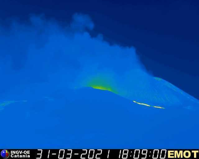
Colours of wonder. Image taken by Lisabet, March 23
The eruption is now some 10 days old. In some ways it has progressed as expected. The row of cones has focussed on one spot, although surprisingly it produced a twin (after exterminating the minor third). The lava is filling the valley but has not found an escape so remains well confined. The Icelanders are flocking towards the eruption: with scant regards for safety. The hill side next to the cone is no longer accessible (phew) but otherwise the sightseers get so close that it is at time hard to see what is smoke from the lava and what from the barbeques. I guess it helps not having to bring your own heat. For the people unlucky enough not to live in Iceland, two cameras have been put up with excellent eruption viewing, freely available worldwide. And of course, those showy Icelanders are using the camera to showcase their lives to the world. Their dogs, their clothes, their phones (a bit creepy to see someone on my screen take a photo of me), even their love lives. (Erupt with a kiss?) Yes, this eruption progressed as expected.
But in other ways, this is an eruption with surprises. Where do we start!
First, the location. The Reykjanes peninsula is chocker block full of holocene lava fields. The tip of the peninsula is still utter devastation, from eruptions that happened in the 13th century (weather and overgrazing may have helped preventing much recovery). But there is one area that has avoided all eruptions since the ice age: between the thermal regions of Krysuvik and the blue lagoon. And the lava decided to come to the surface right in the middle of the safe zone. why??
Second, the source of the magma. It is melted mantle material, without much (if any) melted crust. It has come from 15 km down, not instantly (there was a dike involved which provided temporary storage) but fast. It was expected that over 800 years of silence, magma would have collected in the crust, at 5 km depth or a bit more until there was enough to begin a new eruption cycle. Eruptions here happen cyclical, after all, with of order 1000 years between phases. Previous cycles indeed produced more evolved magma, indicating a more shallow origin. But instead, this magma came from much deeper.
Third, the stability. The eruption rate seems to have settled at 6 m3/s. You would expect the rate to decrease as the pressure in the feeding chamber decreases. That is not happening, as far as we know. That makes it very hard to know what will happen next. Is there now an open conduit to the mantle, allowing the magma to rise up at a constant rate? Or is it like a bagpipe, where a reservoir is slowly being squeezed out at a constant rate, which may be different from the rate at which magma is added to the reservoir? The answer to this will only come when we know whether the magma composition is or is not evolving. At the moment, the MgO content is measured at 9%, in two separate measurements 4 days apart. But that was a week ago and we do not yet know whether it has changed since.
Fourth, the volatility. If this sounds in contradiction to the previous point, know that this refers to how much gas there is in the eruption. It is not too bad. The tourists, even those uncomfortably close to the lava, are not keeling over from the fumes. (It is not healthy either, I should add.) Yesterdays’s reports suggest that this is because the mantle magma had been melted before, resolidified, and them remelted. The first melt had allowed some gas to escape. When the earlier melt happened is not known, of course. It may have been last century, or it may have a long time ago. It may even come from the origin as subducted ocean floor, with the first melt happening on the spreading rift in the ocean that preceded the Atlantic.
https://www.mbl.is/frettir/innlent/2021/03/29/kvikan_likist_mest_staerri_dyngjunum/
Fifth, what caused the flames seen at various times during the eruption? It very much looked like a candle flame, but what was the fuel? Lava may glow, it does not burn. Options are carbon from the soil, hydrogen from oxidization of iron-hydride, and sulfur burning to sulfate. It is only seen away from the strong fountaining.
How will it continue? The big question is, how long will it last. We will let our readers decide: the choice is yours. To give a useful number, at the current eruption rate, it would take 7 months to get to 0.1 km3, and 6 years to get to 1 km3, so it is related to how large you think this will become.
At some point the lava may spill over into the neighbouring valley. The entrance is out of view for both our cameras. But that is ok as the lava is not yet going there but is still flowing towards the deepest point in the valley, away from the exit. It may be a month before that changes.
The two valleys are called Geldingadalir and Meradalir. As pointed out here, those are horsey names, with the first referring the geldings (castrated) and the second to the mares. Apparently the latter got the better valley, with better grazing. The first valley is no more.
Various videos have been made by our commenters. Here is one from astropgraph99, recommended for those who like their lava fast. I love it.
If you like your lava at leisure, we recommend the timelapse by our Virtual commenter. I love this one too.
And some beautiful images taken by Lisabet, on 23 March.


Poll
The results of the poll are
Most votes went to a 6 month duration, with 29% of the votes. The options 1 month, 1 year and longer than 5 years each scored 20%. 5 years got 10%, and 1 week got 1%. Interesting, the people who expect that it will last more than 1 year, tend to go for more than 5 years. But overall, the opinion is that it will last months to years! We can take 6 months as the VC prediction.
Regrettably, two people had to be removed from the voting list as they voted many more times than once. We did allow for multiple voting, but that was in case people could not make up their mind. Not to submit the same vote 10 times or more. If this is you, consider yourself as having been told off and please take a class in Basics of Democracy – one person, one vote!
And of course, volcanoes will completely ignore our voting anyway. But the last we time we took a vote, Reykjanes came out as a high scorer for the next eruption in Iceland. VC commenters have a good track record!


The other timelapse from yesterday from the mbl.is webcam from 23 to 9am it;s continous.
It was a beautiful night
https://youtu.be/EgWk8dpeM7w
the moving “island” is fascinating!
Finally managed to capture a timelapse this evening. It is from the mbl webcam;
https://youtu.be/dQ-dkVL-WnA
On the K100 stream the flow seems to be moving off to the left at a pretty good clip now, but movement is apparent over a large area. I don’t remember seeing it this vigorous before.
It is stronger. The right vent has two streams coming out……
On new webcam to left of the cone at the back, does it look like some new fountaining to anyone else? Either that or a leak at the back of the cone?
Ah, it might be blocks falling into the lava from the cone…
Any more expert views out there?
I saw it too, intermittently in front of the “island” below the cones.
new timelapse from the Viðburðastofa Vestfjarða camera can be found here: https://youtu.be/8JKxaaJUvAo
Just on the flames, a fresh basaltic lava is likely to emit plenty of carbon monoxide, which can combust in air to CO2.
And on the sulfur issue, under the conditions in magma (especially the temperature) sulfur dioxide, elemental sulfur vapour, hydrogen sulfide and water vapour are in thermodynamic equilibrium with each other at fairly similar gas phase concentrations.
2H2S + SO2 ↔ 3S + 2H2O
(I could fire up my copy of HSC Chemistry to work out the relative concentrations but it’d get complicated with the pressure and reducing species like FeO in the magma.)
Once the gas mix hits the atmosphere the presence of oxygen will cause both the H2S and elemental sulfur to burn to SO2, although rapid dilution and cooling can prevent the H2S combusting – so you can get the rotten egg smell.
Please, no oxygen fugacity stuff… that makes my head hurt.
You gotta respect the ‘right’ cone. It looked great at the start, had some collapses, but always strived to rebuild. Then came the upstart to its left and looked to be about to overtake it. But then the right cone again upped its game and now keeps growing in the face of continuous and impressive activity from its neighbor.
Glued to the K100 cam at the moment. I have noticed an uptick in the flow. Some vigorous and rock-filled fountaining occurring.
Presumably the general flow rises and falls over time according to what is going on deep down below.
Right now (2:30am UK time) it is very prodigious with some high fountain blasts.
The whole Cone-complex is sliding down again. Jump between 1 hour ago and now and you can see that everything is sliding slowly towards the camera (Mbl). The right vent already lost a ton of hight.
I have noticed chunks drifting away from both cones, but my question is this? Is the base of the cones against the crust sliding due to the contact heat from the fissure openings? There seems to be back and forth play between the cones building up in height due to spattering and the intense heat melting the lava and making the rock pliable for slippage. Thoughts anyone?
Wow, the new mbl camera just switch from IR-gain to straight light gain… The student darker and more orange steam caught me off guard
small breakout on K100 camera to the left, leaving the screen quite fast!
and now breakout on the right side of screen. I guess the lava channel is quite full atm. all of this 215-230am local camera time.
There’s a crack developing to the right of the right-hand vent (RUV cam) that is smoking heavily at times.
At 3:40:45 am I saw an invisible fire tornado ripping the skin off areas of the lava lake and exposing the liquid lava underneath. Once a huge sheet of lava, just like a large sheet of plywood was peeled off the lake surface and hurled into the air, twisting. You can see the wind’s effect on the lava, as it swirls the yellow-orange material around and droplets into the air along with dark chunks of crust.
I saw 2 of these invisible fire tornados or twisters moving across the lava lake in about a 2 min period.
The only way you would recognize them is the effect that the swirling twister has on the top crust of the lake, but obviously they are generated by the very high temperature just above the surface.
Another fire tornado at 2021-03-31 04:00:56 to 04:01:20 or so, and again at 04:02:03 where the tornado wind literally rips the lava skin off the lake and lifts orange chunks 30 – 40 meters into the air, wow! On the http://k100streymi.mbl.is/spila/webcam0 camera, can anyone record or archive this video? I saw at least 3 fire tornados, the first literally flipped a large chunk of lava skin over backward right up into the air off the lake surface, I would guess the chunk is 10 x 5 meters in size.
These fire tornadoes must have been very strong to rip off the skin of the lava lake. Is this strength comparable to an EF5 tornado?
I would say not that strong, say EF1 or EF2 at the most, but I was surprised to see a whole chunk of lava, like a sheet of plywood tossed up and then backwards in the air. I am hoping mbl.is has archived the film and goes back to the timestamps mentioned. Maybe they will post these video segments? I am hopeful.
Fountaining picked up appreciably at 04:09 am 31-March-2021
Another fire tornado at 2021-03-31 04:13:52 to 04:14:43 spectacular tornado rips the lake apart, I have never seen this before, incredible, but perfect example of a lava heat tornado. Can someone please archive the mbl.is film? http://k100streymi.mbl.is/spila/webcam0
Ahaaa….I saw one too! I don’t know if was small or big but yessss look alike the movements I am familiar with from tornados when rip up whatever is on soil…maybe the heat starts to change whatever happening there…and this bubbling areas wich appears more and more….maybe is the precursor of lava lake forming…a critical mass of molten lava is to be reach soon
i found it on https://www.youtube.com/watch?v=BA-9QzIcr3c Spectacular….!!! have never seen anything like this before…. might want to warn people around the area?? might be due to the high temps of this eruption…
at which timestamp did you find it (time is in the lower left corner)
oh well, I saw the timestamp in the reply above – nevermind!
motsfo, may I ask at what point on the video you found the fire tornado/devil, please?
I would call them lava devils, after dust devils as they are so ephemeral and caused by heat disturbance, rather than any meteorological effect. They are fun to watch, and the degassing bubble fountaining.
video of lava devils is in the works…
Lavanado: https://youtu.be/fsfrZzI3MbM
Good stuff.
Nice!
Perfect! Glad that someone has this on video now. Never saw a lavanado before until last night.
Tremors are starting to get longer and longer at Taal with more low frequency earthquakes, I am thinking the chamber is pressurizing but it’s not like I can confirm it without actually looking at the seismograms. I am 100% sure that Phivolcs are doing everything they can to understand what’s going on at Taal but more comprehensive reports would be nice 🙁
What are you looking for? I see the reports and they give a fairly detailed explanation about the data regarding the tremors, gasses and temp
I would like to know the scale of the recent inflation, at what depth the quakes and tremors are taking place. Stuff like that, the fact that this information isn’t released makes it hard for me to really get into tracking this volcano.
Watching this morning suffering through lack of sleep (averaged 5 hours a night for the last few days) I’m reminded of these lyrics, from a favourite song of mine, which seem very apposite:
‘Rockface moves to press my skin
White liquids turn sour within
Turn fast – turn sour
Turn sweat – turn sour.
Must tell myself that I’m not here.
I’m drowning in a liquid fear.
Bottled in a strong compression,
My distortion shows obsession
In the cave.
Get me out of this cave!’
‘But if I could change to liquid,
I could fill the cracks up in the rock.
But I know that I am solid
And I am my own bad luck.’
A virtual non-existent prize for correct a guess…
Genesis…Lamb lies Down…The Cage?
😀😀😀
Winner! Collect your gold star from the emoji list.
Thanks Rael 😃
I’m more mutton than lamb, and more Ripples than Rael!
More thinking.
1. There seems to be more degassing bubbling/mini-fountaining going on, especially after surges work their way through the lava lake. Is this due to disturbance or friction or something else?
2. Could the lava composition be changing? Looking inside the fountaining, sometimes it seems more liquid, like single cream and other times, much thicker and viscous, like semi-whipped cream.
It looks like the left vent, or Gollum vent as jesper puts it, is getting to be more active. Lava effusion is about the same from both but the fountains at the left vent are much bigger, the taller bursts look to be going up to 80 meters high at times, and it is sustained now at around 40 meters.
Thats correct Gollum vent ( western vent ) is becomming dominant. I will name the entire lava field ”Saurons Lava”
And the cone complex will be named ”Morgoth Cone Complex”
Gollum vent is forming a nice lava fountain .. But still not forming a boiling bathtub around it. I also wonder If these lava channels will tube over.. or perhaps the eruption rates are too high.. for now its fountain feeding open lava channels with thin skinn riding on top.
These two vents may produce lava shields similar to Surtsey pahoehoe phase 1964 – 1966 If eruption rate slow a bit
Still too high to produce a pahoehoe shield, theres been more than enough study from Hawaii to show that those are formed at eruption rates of around 4-5 m3/s or less, anything much above 5 m3/s will form a’a even if the flow is not on a steep slope.
Officially the eruption rate here is about on this point but all the cases of the flow going beyond the immediate area of the vent it turns to a’a, and it is very atypical for an eruption at that sort of rate to fountain, let alone to tens of meters in height, I think the eruption rate is being underestimated a bit, or that the effusion rate given is for the DRE which is going to be a lot less than the actual lava because of the gas content.
Note the rate of inflow is supposedly unchanged and some 3x the rate of eruption…
If my article does get published soon you will see that a shield isnt the only outcome… 🙂
There was a graph posted in one of the other threads, from the IMO twitter feed I think, that showed activity was slowly increasing. That was probably almost a week ago though now.
Id say it is still increasing now. It is hard to get a sense of scale but you can directly compare the early cone with how it looks now by comparing to the still remaining part of that hill the eruption began on.
The taller vent looks by itself to be comparable to its activity a week ago, yet it is now the secondary, the left vent is much more active. Without further investigation it looks to be well over double the output now as when it began.
I red somewhere imo expects a 0.5 m3/s increase per day.
Once lava tubes are well established they can have a very high lava flow rate inside them some of kilaueas larger tubes Kazumura must have flowed at 10 cubic meters a second or more at some moments. Well established Lava tubes at Puu Oo often had crazy flow rates like pressurized body arteries .. and sometimes skylights flowing over with creeply fast surface flows that turns to Aa
But that requires lava tubes to form first from slow eruptions…
Surtsey had an Impressive flow rate inside its tubes 1964 – 1966 and If a tube breaks open .. you gets fast moving sheet pahoehoe and Aa flows downslope.
Smeagol is trying to grant your wish for tubing over. Did you see the cave troll between them?
Chad, it appears that photogrammetry using the Pleiades Satellite https://earth.esa.int/web/eoportal/satellite-missions/p/pleiades is being used to check the flow rate.
Was that an earthquake with the mbl camera, not enough wind?
some of those cam movements deff look like earthquakes…. they don’t match the fumes movements.
Last night, when I was watching the lava devils swirling around, the mbl.is camera shook just exactly like a spent wind gust from these lava devils had reached the camera area, and then subsided. I would say that these thermal cyclonic wind gusts are shaking the camera.
I watched the mbl.is cam just now 16:48 pm and it is definitely the blowing wind causing the camera jitters. Perhaps someone can persuade mbl.is to better anchor their camera?
Yes must be wind, just haven’t noticed it before. lol
Nice up close view.
Using google earth back in time facility, it shows the green grass of the valleys horse pasture quite nicely.
Whilst looking at these different satellite and air merged photographs is is apparent that this volcano has erupted before IMO
The burial ground is behind a ridge, the ridge looks like one of those pieces of detached cone islands that has made its way down the lava field.
This is an existing volcano if the burial ground ridge is what I think it is.
Just use Google earths back in time facility and some of the shots really show the ridge up quite well.
The reason I was looking, is that if these sort of eruptions have happened before in this area the detached pieces of cone will still be there 1000,s years later, I think.
What do you think, am I barking up the wrong tree or just barking? lol.
Regarding the vote, I picked five years, but if my detached ridge theory is correct, the eruption may not fill the valley and end quite soon leaving those detached ridge/cone pieces as a reminder. like previous eruption/s
Of course I could be right about the detachment and wrong about the time or both!
Good logical analysis. I’ve been thinking that the ‘burial’ ridge was being drowned by a grass bog, to account for the flat terrain, but it could equally be a buried lava pond surface.
There is a wonderful high resolution IR map at
https://www.maps.is/base/@339625,380363,z8,4
See if these support your thesis. I’m not completely sure what the terrain colors actually say about its texture or origin. The website is good place for map lovers anyway.
Thank you, it shows the horse pasture up quite well.
1000 years and more of animal grazing would certainly improve the area for agriculture.
The lava we see erupted I suggest would be eroded down by weather and agricultural grazing animals in a 1000 years or so quite easily, except those islands of detached spatter cone.
The lava is easily broken by hand but the spatter cone walls are tough as rock.
So if this is true this is an eruption from an existing vent.
I fully except that this is only an hypothesis and until the full Volcano café forum has talked it through it is not a settled fact.
I suggest that if this site erupted in the past, it was after the end of glaciation but before Icelandic historical records and sagas..
That’s an interesting hypothesis and that mound was an odd looking feature, can certainly see why it is/was assumed to be potentially man made. I assume there must be other examples of flank collapse of spatter cones coming to rest in lava flows?
Another possibility is it to be the remnant of a rootless cone?
Getting a good shaking right now…
But the RUV cam is rock solid.
Windy morning in Iceland. The smoke not rising much and going more in a horizontal line, is a good indication of the current wind conditions.
I found that photo I mentioned of Geldingadalur before the eruption taken from the same place as the RUV cam sits. I can’t figure out how to get the photo directly on here – maybe someone else can. Here’s the link to Dan Mann’s tweet with it though. https://twitter.com/DJCManns/status/1374252852277825536?s=20
Here you go
Thanks 🙂
Can we infer that the hillock from which fissure eruption occurred is an ancient spatter cone? Apparently the weakest point in the crust was at this location, and it is interesting that apparently this was a previous vent area.
The north vent keeps growing a roof, judging from the view on the Ruv cam. You can see the fountaining hitting the underside of it in the zoom sequence at 10:30, then the roof maxes at 10:55 and you can see some of it falling a few minutes later.
There appears to have been a surge of lava moving through the RUV webcam view starting before 12 noon approximately. Not sure what caused it. The lava meanders at far left on the middle zoom setting are very full, the rapids have almost disappeared.
Collapse of Norđri’s rear wall at 12.27 and sideways fountaining thereafter.
The right vent (Stan) developed a sort of dome (which is a stable construction)….i suppose will go undercover
I think it depends if the overhang is stable enough to withstand the battering (in the fish-and-chips sense). If the flow gets roofed over too, it could possibly succeed in burying itself.
I’ve an idea that Norđri may be modifying its supply pipe to be more efficient at transport, as it seems to be getting stronger compared to Suđri. Suđri is having trouble clearing its throat of the huge blocking boulders that have forced the elevation of the lava level within the vent. Norđri has shown it is capable of eroding back down to its base level quickly.
I want to do some tracking of the levels for both cones as they have been so mis-matched lately.
Well the Township of Grindavík has posted an online poll asking people for naming suggestions for both the lava fields And the craters that are erupting.
https://www.surveymonkey.com/r/K9M8FBS?fbclid=IwAR1iRn2ak37Es5yUUAUw2m-XpAraC0UxUwGTlBBfxxcxSwHsZqCv4CYeZEk
#1 propose a name to the lava field
#2 justification/argument for the proposal
#3 propose a name for the craters
#4 justification/argument for that proposal
#5 what postal code you currently reside in
#6 name and phone number (optional)
Are entries from outside the town welcomed, or is this just for residents?
Looks like the suggestions are open to everybody but are using the postal code question to give residents more weight, maybe?
All i know is that the system accepted my entry which includes both the Icelandic postal code and the current US zip code
Cool!
I hope the villagers somehow put the burial ground in the name.
Especially so if the outcrop by the burial ground turns out to be a migrated collapsed cone side from a previous eruption of this vent area or volcano.
I heard that the quick survey by one archaeologist threw some doubt on the grave theory, but it would be nice to have both the valley name and the cultural history celebrated.
And I do like the simplicity and meaning of Fagrahraun.
How ’bout Foghraun Leghraun?
🙄🤪😛
Leghraun means uterus lava 😂😂😂
Can’t recall seeing fog- in Icelandic but that name would still work, probably be pronounced a bit different with the g in that position being a voiced velar fricative [ɣ], though being followed by an h it might result in an unvoiced velar fricative
Lava McLavaFace? Anyone???
There’s always one…
*sigh*
Usually, it’s me… 😀
I have filled in this survey and I mentioned my postal code, my residence and that I live in the Netherlands.
More Lavanados or Fire Devils or Firenados or however you might call them: https://youtu.be/C0JZ9hQeWdY The force is really impressive, and even though it is difficult to judge the size, I think the pieces of Lava are pretty substantial – are there other examples of such an occurance? https://youtu.be/C0JZ9hQeWdY
The cooled surface lava that I have seen handled on video, looks light and airy and crumbles when squeezed by hand, I suggest that you are seeing a fire devil that is strong enough to pick up this light and airy surface lava.
Is that from the spatter, a’ā, or pahoehoe?
well, I saw a whole sheet picked up and thrown backwards, my best guess is about 10×5 meters in size, just exactly like a sheet of plywood, so the lava had to be more stiff than light and airy stuff. I do have the timestamp on that one around 03:45 am +/- 30 secs
I’ll have to find the playback video, it had disappeared by the time I looked.
here is the sequence of the lavanado you have found: https://youtu.be/ze3UptlD8JQ I left in a bit of fountaining at the start, and also mixed it with daylight footage to give a sense of scale.
Thank you so much!
I think the push for the eastern exit has begun. There’ a bit of broken off cone that’s starting to divert the lava river round the back of the cones.
Big roof collapse at 14:51 on Suđri
Nice catch.
Did you see how the debris was lifted by the bubble bursting force several times, trying to cough it out ?A large piece got pushed across the overflow, and for a time lava was fountaining both upwards and through a gap underneath the crossbeam.
Suđri had a furball. Jesper, how would you describe it for LOTR?
And at 16.45pm, another Suđri lump cracks, holds on for grim life, before a slow slide to oblivion at 16.59, pausing only to split the stream just over the vent lip.
Shame about the #IcelandicGrockles.
It finally crashed into the lake! 17.30 is, forgot to check the time, watching on webcam 3. Surge imminently.
At the moment I don’t see any public on the MBL livestream. And the camera is still shaking. Has the eruption site been closed for public today?
Wind is going in this direction so all the people are on the other side of the valley today.
Here the weather maps of the Atlantic and Europe for today. There is an area of high pressure south of Iceland, which is also visible at the 500 hPa level, and the jetstream is just north of Iceland.
Source: http://www.wetterzentrale.de
Source: https://www.knmi.nl/nederland-nu/weer/waarschuwingen-en-verwachtingen/weerkaarten
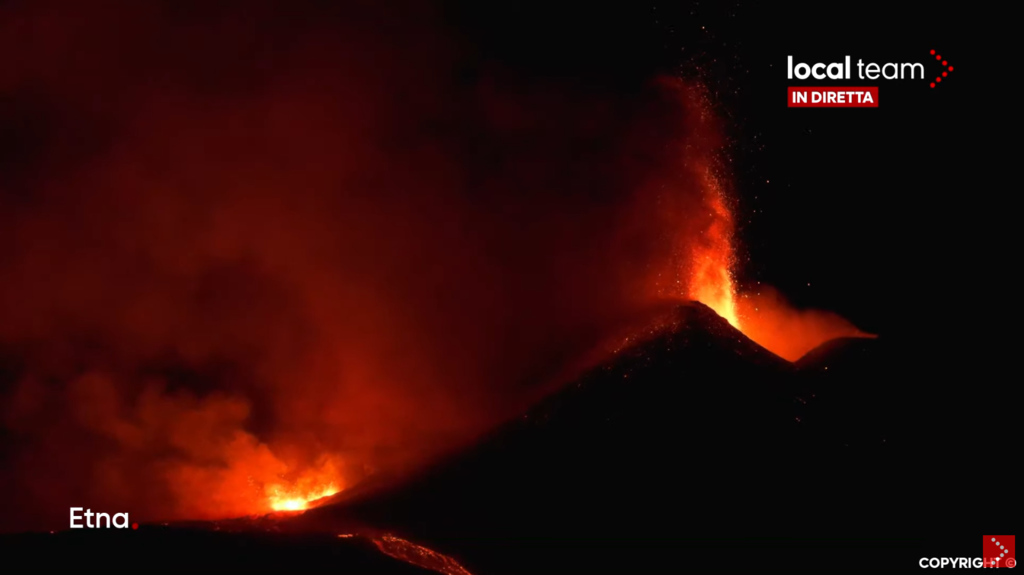
Looks like a new vent has opened below the southeast crater of Etna. Screenshot from vedetta livestream:

https://www.youtube.com/watch?v=ULbuPLm6eNU
Comes with a lava flow:
Source: https://www.ct.ingv.it/index.php/monitoraggio-e-sorveglianza/segnali-in-tempo-reale/video-sorveglianza-vulcanica-etna
Going strong, the new one!

Boris will be pleased. Is this a new paroxysm? I can’t remember how many we’re up to by now. 19th?
Should be no 17. No official confirmation from Boris yet though.
In the Holuhraun days, it was fun to spot acid and lava tornados on the lava field looking at the the Mila cam.
Youtube has some nice footage.
The first vid is spectaculair, taken above the eruption site, Baugur.
https://youtu.be/I7HnnW8HbyQ
This one above Holuhrauns lavariver.
https://youtu.be/1CqKgzI9ll4
And taken using a thermo cam.
https://youtu.be/JibBlRG3lDQ
Rob, thank you for posting these, I’ve not seen them before. The IR video is particularly interesting.
OH, i remember NOW…. i’d forgotten… Carl reminded me last night and Your clip brought it all back. Some of the arial shots of the tornadic formations were spectacular… (sucks to get old) motsfo
There were a lot of lava tornadoes on kilauea in 2018 too, and theres a video of them at Hekla in 1970. Probably they are a long observed phenomenon just one that isnt on video that much.
In the encircled area I see a kind of a face with eyes and a nose.
That’s the area that somebody described as slow rotational slumping. I’m so sorry I cannot recall who posted that, I’ve been watching it on and off. I’m not convinced of the rotational element, but it seems to give way a bit, once the spatter weight becomes too much for the more loose fountaining scoria. Then the cycle starts again.
Early evening light make colors amazing.. And a profile of a face show up in rock formation between the wents.. Little looking like a former president. 🙂
A president…? They are trolls! It is Islands custom, volcanoes hiding trolls!
Look in this map (bedrock under vatnajökull) for faces carefully, you’ll find several of them. 😬
Orcs…
Not orange enough.
I keep seeing the profile of a cave troll there.
For you Instagram users out there. The user h0rdur has some really nice ‘grams. Perfect for desktop wallpapers!
https://www.instagram.com/p/CNA9W-gBh7I/?igshid=1fs6acxfh2jxt
On the left vent (south?) at 1922:30, a ‘large’ piece split off near the bottom left.
Fortunately the nimrod moved away before the piece came off. Someone up thread (or a previous topic) opined about sacrifices to the volcano god…me thinks we have *many* candidates.
(and now they are starting to bother the mbl camera as well….can we take up donations to provide a raised perch for both?)
Poll results have been added to the post above! The VC prediction is for 6 more months.
And an interesting tidbits: our Iceland voters (about 10% of the total legal votes) by majority went for more than 5 years.
The number of countries that voted: 39. We even had votes from Greenland!
The right vent I suppose it got a serious dome up, lava burst are only few and about to be horizontal despite la lava flow it serve to the valley
At the rate it’s currently erupting lava, how long might it be before the lava starts spilling out of the Geldingadalur valley into the adjacent valley (what’s it called again – I’m not so good at remembering Icelandic names!)?
On the mbl camera, on the left vent, is that a breakthrough from the vent to the lava lake that heads towards that valley exit?
I think you’re right.
It’s been pouring steadily through there all day. I’m tracking the lava paths for a pet project, which I’m thinking of starting. I may possibly share here, depending on how it goes in the next few days.
We would be very interested in a contribution!
Yes, given that the current main path of the lava river is towards the exit, it might not be very long before it enters the adjacent valley. Maybe before the end of this week?
That would be awesome!
It’s hard to tell just how much lava is heading in each direction, of course. There’s not only the surface flows, but inflation from hidden pathways underneath.
If anyone spots any lidar schematics please point them in my direction. I would be extremely thankful.
It’s just so frustrating not to have a high level view of the whole valley landscape and the area just beyond.
As for a high level view….would that live drone that is broadcasting now (especially if it’ll be running at dawn/sunset) be of any help with your research?
Northerncanuck it’s entirely possible, depending on the speed and whether I can get decent focussed screen-grabs. I’ll mainly use drone and helicopter footage for orientation and mental map building. Maps and diagrams are oxygen to me. My brain works visually and spatially, and that’s why I’m a geographer!
Etna: Local Team got its live coverage of 17th paroxysm up:
https://youtu.be/vJ8U19x8DzE
I am running out of monitors!
Thanks to the “smart TVs”, YouTube can be run on the telly, freeing up computer resources 🙂
Well yes but I can’t play two youtube videos simultaneously with picture in picture mode unless I’m using it as a monitor 🙂
50″ screen, Samsung tablet and Motorola phone ftw 😉
(I’m so sorry, Etna, but Iceland has had my heart since Heimey)
Volcano Discovery has cross their links on Etna, but it took awhile to locate the seismograph near Catonia. It looks like we’re only getting started on the 17th paroxysm, looking at that monitor and the shape of the curve looks like a large paroxysm is in the works. 23:49 UTC 31-Mar-2021
For different view of Etna https://www.facebook.com/localteamtv/videos/813168966075655/
Sorry Barbara didn’t see yours before I posted
No problem, Chris 🙂 The show is worth being recommended twice. I think I watched the local team climbing up to their current viewpoint two hours ago at the livecam of the funivia (cable railway) on the skyline-cam. Good job! Looks like they always chose their bellavista according to the ongoing action.
With the baby in Geldingadalir sporting two vents, Etna just said: Hold my beer … lol.
Magnificent. Boris’ camera has been such an asset for him.
I suppose he’s been a bit busy for a visit to the Volcanocafe recently.
Looks like the eastern vent ( Smeagol ) is starting to tube over : ) http://k100streymi.mbl.is/spila/webcam0
which one is which again? There is no direction on those streams. Which one is the perched one?
Nordri and sudri are the common designations. North is left, south is right. But who’s to argue with Smeagol? He has the ring in his pocket. Or does he? That sneaky baggins!
Well, you seem to know more than nothing, Jon 😉
The lava river vent right of the large fountain
Lost more of the lower left sidewall (on the left vent) per mbl camera (@2126:29) but can’t confirm it with the ruv camera….the opening at the bottom is larger, though. That breakthrough (tube?) appears to be still flowing fine.
2 new timelapses from yesterday to today. A lot of work to remove everyone (which explains the zoom) but it looks beautiful as ever.
mbl webcam https://youtu.be/YbfQY67oZo8
ruv webcam
https://youtu.be/cIYXyYnpsIA
Great job Virtual!
Oooh goody goody. Well done for eliminating the grockles. I wonder if there’s an Icelandic equivalent?
Virtual-huge thanks! These timelapses are greatly enjoyable and very informative.
This is recorded yesterday, the 30th March.
At the end there are three or four views of the valley, parts of the lava field, and overhead shots of the vents.
I am surprised at how little lava is flowing eastwards (with the caveat of unknown subsurface flows and the last 24 hours of outpourings); the vast majority is flowing west and then south in the well established horseshoe pattern that has been there almost from the start.
More, please, my addiction needs feeding!
Could be an effect of the camera angle but the the lava to the left of the RUV.is webcam image seemed to be flowing downhill n the shots when the camera panned to the left on 31.03.2021. If it is flowing downhill, it may go faster or appear to.
Ignore that; think I got north and south mixed up.
A great picture with an overview of the whole valley.
https://www.mbl.is/frettir/innlent/2021/03/31/dalurinn_haegt_og_rolega_ad_fyllast/
It doesn’t translate into English like most pages do, but those maps and photos are perfect!