Source: https://www.visir.is/g/20212093433d/ny-sprunga-ad-opnast-a-reykja-nes-skaga
The eruption in Geldingadalir seemed to be waning. The flows from the two cones were notably weaker this morning. The cracks in the back of the cones which has been emitting steam had stopped doing so. The raised lava pool in front of the cones was emptying, and earthquake activity was almost absent. Activity has gone up and down over the past week, but this was definitely a down. Even the Icelandic activist making a nuisance of themselves in front of the cameras (and not being a particularly good advertisement for the country) were largely absent. The valley was largely filled with lava but the edges were not rising very fast. Yes , the eruption was definitely in advanced middle age.
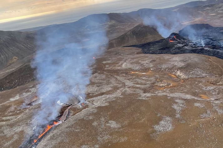
At 11:32 today UTC), weak earthquakes occurred in the area. They were only about 1 km deep. At 11:37 a stronger event happened. And suddenly, reports appeared of a new fissure which had opened. By luck, it was in view of the main camera (but behind the second one) and we had an immediate good view. The fissure is perhaps 500 meters long, is showing weak fountaining along its length, and is producing some lava. It is located 1 km northeast of the twin peaks. That puts it along the dike, and this is clearly fed by magma in the dike.
The location is on the high plateau adjacent to Geldingadalir. We have had discussions which way the lava would take out of that valley; the most likely route involved a roundabout way to get to the Meradalir valley. It was unlikely to make it at the current flow rate: it would likely solidify on the way. It turns out, the lava found a better way, underground. The new fissure is near a gully that empties into Meradalir. The lava quickly found its way into this gully (which is no more), and within hours reached the floor of the valley. It is now expanding into Meradalir, albeit out of sight of the cameras.
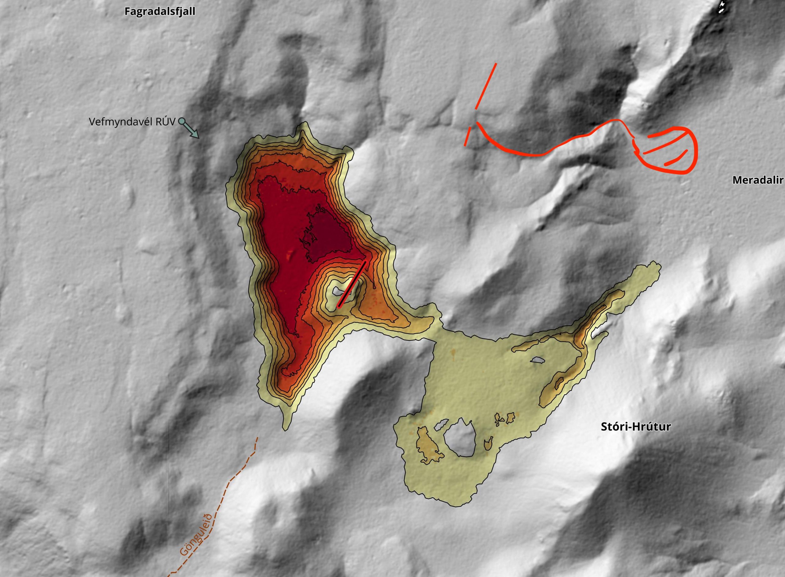
The map shows the approximate location of the new fissure. The accuracy is not guaranteed! (This is an updated version, which moved the fissure to the far side of the gully). (Update 2: the extended fissure is beyond the gully, as pointed out by Reykvolc. This has been added to the drawing.)
The map shows the Geldingadalir flow, as it was expected to develop. The yellow area shows what was needed to get an overflow into the next valley, with a roundabout path to the lower valley of Meradalir. The magma decided against this and choose a short-cut instead. The red line show the new fissure (it is a bit guess work and I have assumed it is perfectly aligned with the original fissure which may not be true). It shows the two gullies, and indicates the one which the lava has chosen.

What caused this new fissure? There are two possibilities. One is that the magma pathway to the twin peaks was beginning to be blocked, and that the backed-up underground flow found a new weak spot. The second possibility is that the dike was slowly closing as the magma inside was cooling and that this squeezed out the remaining liquid. To tell we need to know the composition of the new lava. It is hard to tell the viscosity when it is flowing through such a steep gully.
How will it evolve? If it behaves like a normal fissure, then the new eruption will quickly focus on one or two spots, with the rest of the fissure ending its activity. This may be happening already as most of the fountaining now comes from two or three spots at the middle of the fissure. However, there is also new fountaining activity at the end of the fissure where it approaches the gully. A southerly extension of the new fissure has opened up here in the past hours which may take over from the earlier fissure. Four cones can be recognized along the fissure, including two in the new extension. The northeastern end of the fissure has a ridge only.

https://www.facebook.com/Almannavarnir/photos/pcb.4244255905606160/4244254928939591
We already have the first time lapse of the new fissure, thanks to astropgrah99
It is guesswork whether this new fissure will become the main eruption site or that it will be a short-lived excursion. It is fun to guess though. If it continues, the fissure could extend further towards the valley, purely because that would be a shorter way to travel for the magma. It may be time for a new camera.
How about the old eruption? The activity there remains notably weak. The two cones are slowly being eaten away from the inside, with frequent minor collapses. The cones are both cracked and if the eruption continues, may collapse. The surface flows now stay close to the cones. They have build up a lava pond enclosed in levees, and every now and then a levee develops a leak and a break out happens. Much of the flow is out of sight. The flow rate is hard to judge by eye. The composition remains fairly primitive (for Reykjanes), suggesting this is magma that had collected around 15 km deep at the interface between the deep crust above and the mantle below. how long it spend in the dike is not known, but there was no indication that the magma was aging during the eruption. That would be expected if the eruption was fed purely from the dike.
Time lapses of the ‘old’ eruption thanks to Virtual
Finally, the poll we had on the duration of the eruption has given a clear winner. We had over 500 responses, from 40 different countries as far apart as Greenland and New Zealand. Regrettably, two voters had to be disqualified for submitting multiple identical responses. The electoral authorities in their respective countries have been informed. After this edit, we received the following votes (note that ‘Longer’ means longer than 5 years):

Interesting, if we look at votes from Iceland only (in the ranking of umber of voters per country, Iceland was fourth), a different picture emerges:

Are these votes from the Iceland tourist board? I guess time will tell! So far, this is a typical Icelandic fissure eruption with a dike, multiple eruption sites and some but not enormous amounts of magma. The only uncommon aspect is the lack of involvement of a central volcano. We do not expect that a central volcano will develop here: that is not the way of Reykjanes. Once this eruption is over (whenever that will be), the next eruption will occur somewhere else on the peninsula and it will firget about this fissure.
There have been suggestions a shield may develop here. That would be most unusual, but cannot be excluded. However the new fissure indicates that the eruption has not yet reached stability. Wait and see. Iceland may yet surprise us. Again.
Albert


Awoken this morning to discover the sad fate of the mbl camera – RIP fella, thanks for the memories 🙁
(honestly though, that was my favourite one!)
I should know better than to leave a fissure eruption to sputter along unwatched for a couple of days… Quite a change !
Well.. weather dont shine on the iceland drama stage, so i may take a dog walk. Unfortunately it dont look much better outside here. Probleby the whole rift zone start when i am away.
As I see, Geldingadalir-Maredalir eruption is going down now. Only in old crater some lava is visible.
Mind you that lava is less visible in daylight and that the old twins are the only source with a camera relatively close.
On the RUV Meradalir cam you can still see sputtering in the Easter Monday cone but last nights cone is too far away and too well hidden by weather to see if it is doing anything
On the new mbl cam, which is now zoomed in on those two locations you can still see sputtering from them both
Think it is the weather obscuring the view.
neah…no way! just sheltering itself from blizzard…I dont iven let dog out in this place!
If the tremors on all freq go high means wind or is sometrhing about to happening?
Wind – there’s been a snowstorm going for hours now. Unless there’s volcanic tremor happening at the same time as bad weather and as such is masked by it, you’re looking for only an increased low frequency signal.
Is there any actual serious discussion about what to name these new cones? The eruption is evolving but it is unlikely they will actually be destroyed entirely, if anything over the course of the eruption and maybe several eruptive episodes these cones will only grow bigger.
That being said if more cones are created it would end up looking like a spatter rampart even though there was no large scale curtain of fire stage, a cone row would get a different name than a distinct cone or crater. If it does ultimately become a cone row though that is going to be called Chadagigar, it looks like it is going in this direction so things are going well 🙂
Well since there is only one of you – assuming you do not have disassociative disorder – the name would be Chadsgígar. Then again, *C* does not exist in Icelandic, nor does the sound represented by the Ch in your name, so if they name them after you it would be Tjadsgígar
But on the more serious note, last week I posted in the comments a link to an online survey by the Township of Grindarvík, where they were asking 5 questions,
Name of the lavafield
Justification of suggestion
Name of the [original] craters
justification of suggestion
Current postal code
{and optionally} name and phone number
By RUV webcams two cones have names, First is Geldingadalir. Second Maredalir and the last new one hasn’t name yet, but maybe soon.
correct, Meradalir
Those are not names of the cones, but the names of the valleys where lava collects.
Has anyone seen evidence of a westerly flow from the Easter Monday vent/cone?
Good news from Mbl about their camera close to the twins. The camera is alright and operational but a power cable was destroyed by the lava. The camera also has solar cells that should start the camera again if there is enough sunlight (probably not during this blizzard).
https://www.mbl.is/frettir/innlent/2021/04/07/nyja_sprungan_myndast_myndskeid/
Wonderful news! I eagerly await the return of ZombieCam 🙂
Yeeeeeiiiii back to be able to see Gollum and Smeagol vents .. where the eruption began
Unless the camera was physically pulled by the power cable I wonder if they might be a bit optimistic as the camera was certainly moving (mainly tilting up) in the last minute of the stream.
I’ll keep my fingers crossed though.
Here’s a gif showing the change in camera view over the last minute of stream. Taken from recording posted by fjallaback earlier today.
Power cable? From a portable generator presumably.
From an interview with one of the geologists there were several devices from IMO in that vicinity that cut out about the same time. So chances are they were sharing some portable generator or battery pack
Thanks! Maybe the actual power source succumbed to the lava. I was watching the original RUV cam at the time, and thought I saw a brief sparkle of burning around the time MBL cut out, but that could easily just be my imagination filling the gaps.
Timelapses from yesterday to today:
RUV 1: https://youtu.be/Biz3hIIUAos
RUV 2: https://youtu.be/Xf0fsAzctK0
MBL: https://youtu.be/AWZTdZDFfLA
I love this volcano and am eagerly looking forward to seeing it in person!
Looking great Philipp! Thanks.
The mbl is fabulous…
All cameras in one page https://maps.acme.to/gos/
Also added still images from webcam on Langihryggur recording lavaflow. Near by roadside cameras showing trafic (Grindavíkurvegur and Rekjanesbraut)
And many other pieces of information (see map https://maps.acme.to/gos/ )
*sashays into the comments, volcaccino in hand*
Hiya everypeeps. Anything going on RN? What did I miss?
Wednesday
07.04.2021 12:34:31 63.883 -22.383 6.0 km 3.3 99.0 5.7 km NNE of Grindavík
Tree star quake west of eruption site.
I tried to make an overview of the current lavaflow (and realised I am terrible at drawing and have no computerskills, so feel free to improve and correct!).. but here goes
http://imgur.com/gallery/mXhIiXS
O and purple arrow is where I put the 3th fissure, but I wasnt sure.
New louder rumblings ongoing. Should we have betting ongoing when/where the next crack will open? https://www.vedur.is/skjalftar-og-eldgos/jardskjalftar/reykjanesskagi/
What a fantastic night.
Weather is clearing now.
Magma activity is lower?
Impressive lava flow now… from the Morgoth vent… perhaps 20 cubic meters a second… braided lava rivers pouring down the valley… as well as a lava lake boiling inside the spatter cone
https://k100streymi.mbl.is/p2p/webcam1
Camera here… Morgoth spatter cone… and quite big too it have grown
Is the new fissure/vent Bilbo or Frodo? Or is it just Bagginssssses?
Morgoth or Melkor??
Data of new gps stations around the eruption site is added.
http://brunnur.vedur.is/gps/reykjanes.html
Looks it going to depend where cone(s) going to get a brake out where the lava flow going. they both are placed on a little high point. Can go back to nr 1 place or down the steep gorge
https://twitter.com/RobAskew2/status/1379798966183809027
Major collapse of the main cone of Geldingadalur just now. Started at 14.42 with another around 14:53.
It looks like the collapse started at the top of the right cone, then cascaded down into the lava delta.
Not sure, but the bridge between the two cones may have been compromised as well?
With all the new lava being erupted from various the eruption sites, the total flow by now must be near 10m3/s?…or an actual increase over the original 5m3/s. A possible explanation is there is increasing decompression (decreased compression) at depth which is increasing the magma flow to the surface. . Under this scenario, the entire 10km long dike is likely to eventaully open up….but that’s just a guess on my part.
The bridge between the two cones at Geldingadalur survived the latest avalanche….although the north cone lava is now flowing constantly into the drainage channel while it was intermittent before that.
What cam are you using to see this?
Fantastic video by Marco di Marco, first you see the new fissure that opened tonight, next the second and how it grew in just one day
Icelandair giving a treat arriving to Keflavik. This is from yesterday – no fissure 3.
https://twitter.com/LeeProud/status/1379471527586975748?s=20
I tried to make a map that makes sense using the one presented in this article.
Green: cams (not sure about the ruv meradalir cam)
orange flow fissure1
red flow fissure 2
green flows fissure 3
and the expected pathway for the merging flows 1 and 3 to join eventually flow 2.
Click to enlarge.
Please shoot!
Thanks Rob that’s helpful.
Very helpful! Thank you. A couple of things – fissure 3 is pink not green, and the fissure 2 flows down the second gully last night are missing. Hope you don’t mind me mentioning it!
Geat map! Really helps to put everything into place. I added some stuff from last night. And I’m 95% sure your mbl 2 cam position is wrong. I put it in the right place. Maybe you can use my changes if you ever make another version of the map.
I think there is also a flow from between fissure 2 and 3 flowing towards geldingadalir (see ruv 1 cam). On the map this flows left following the gully.
Oooooo, big kipuka on the cards!?
Nice map! Perhaps mbl2 is somewhere on the flank north of stori-hrutur? Anyone have a translation for stori-hrutur?
stori-hrutur
stori = big
hrutur = ram (opposite to ewe)
I believe you have the mbl 2 cam on the wrong side of the flow. When you watch that live stream fissure 2 (F2) cone is on the right hand side, and it is quite a distance away – last night all three eruption points could be seen on it – and you can tell where the F2 flows are starting to go down the gullies. So in opinion it should be up on the “sharp” ridge south east of fissure 3 (F3). My guess closer in lne with F3’s top block on your map
RUV Meradalir cam is off that map. It is on the far slopes of the dale, almost facing the center of the kipuka between the two fiery gullies
If mbl 1 gets re-upped my guess is it will be moved about 50-100 metres north to northeast. Moving up the slope to avoid possible breakouts from fissure 3.
Thanks all for commenting/adjusting!
Yaaayyyy! I have a flow and in competition with the Icelandic fissures as I stat 3 weeks worth of laundry. All good and finished. We have drainage again! Too busy to stay long watching. Tonight I can catch up!
RUV is making rounds of fissure close ups. There is a helicopter landed next to fissure 3, unfortunately on the wrong side of the flow to assist our favourite mbl camera.
Relief map of the site from yesterday, It shows the location of the Meradalir RÚV camera location if anyone is interested
https://twitter.com/geoviews/status/1379373583407931394/photo/1
I just visited the blog first time today and got surprised again. Fissure 3?
Any live streams from it or pictures?
https://gyazo.com/6be8c156ac1738ae060ea0d3b408cec7 – A screengrab I took last night when the whole thing was unzipping
https://gyazo.com/abff1708087d9d870a950090e1deda5a – An indirect photo of it; you can see the lava flow on its way to eat the camera…
It can be seen from ruv 1 (geldingadalir) from 00.00 last night and now still (if it doesnt snow). They also added another mbl cam, someone else can give you the exact link.
The original mbl.is cam is experiencing some technical difficulties, the new lavaflow burned the powercable. But you can probably rewind and see the flow until it cuts out at 8.19-ish.
Astrograph99 at 12:55 above has a post with links to timelapses from three different cameras.
its before 3 fissure arrive on the stage, but give a good view how aria looks..
also some nice shots on lava flow and some bearings. and landmarks
Sad news on the mbl camera:
https://www.mbl.is/frettir/innlent/2021/04/07/vefmyndavelin_komin_undir_hraun/
The camera didn’t make it
and the lava stopped THERE…. it couldn’t have stopped just one foot shy?? nuts
not nuts but murphy-ed
Maybe it can be recovered? Just a bit of chiseling and a bit of buffing and it’ll be just fine…
little bit of t-cut and a polish, should be fine 😀
That’s covered under warranty, right?
Right? 🙂
It died a warrior’s death, somewhere there is a live stream of Valhalla
I guess that explains the tilting during the last two minutes.
That is perfect.
Aerial view of all vents together by IMO.
https://pbs.twimg.com/media/EyZEvRKXIAo5UFn?format=jpg&name=large
Nice one, thanks!
“Mavic Pro Drone with flawed gimbal decided to fly into the volcano in Iceland. Amazing footage recovered from the mobile phone recording. As the memory card was non retrievable :)”
Why would someone flew his drone into a volcano????
Can’t believe it, for 13 sec. of video
The gimbal on my Mavic is a bit iffy, I’m going to send it for a service, wouldn’t kill it like that !
He should have gone down into the lava rather than crash into the wall 😛
Will the insurance pay out ?
Some people have money to burn.
Lol, at the end of the video YouTube suggested me this other video to play next. Even Rachmaninov facepalmed after watching the drone sacrifice
awesome!
Its probably just an unintended crash.
If it was deliberately, he likely would have crashed it into the heart of the eruption. And not just on the crater wall in a straight line.
https://www.youtube.com/watch?v=ppnN94WK960
RVK newscast good footage of fissure 2 and a walk all around both sites, lava stream etc.
Certainly puts the area into perspective.
Pre fissure 3, this was shot yesterday.
Sorry a repost of Swepol67’s post, I didn’t update page before posting!
Not a problem 🙂 Would be nice walk there. If weather good like at that time. He must have walk over fissure 3
I was watching this RVK newscast (thank you for posting it) and I noticed what looked like a small lava outbreak in the background. Not active, but it looked out of place.
Here it is:
Wonder what it is?
Looks like a rock in shadow to me, but thats without knowing where it is exactly.
This could be the tip of the original Geldingadalir flow. The arial photos posted yesterday showed it was not that far away from where it could spill over towards Meradalir itself
Hard to tell. It looks black because it is casting a shade. What is casting the shade is not clear. A small cliff, perhaps
While we wait out the storm here is the most recent official map of the lava flow.
I don’t know how to post images but you will find it under the webcams.
https://www.ruv.is/frett/2021/03/18/bein-utsending-fra-gosstodvunum-nyjar-sprungur-opnast
Well, yes…. our map is better. 😉
True
The map:

Copied the map to image hosting website since direct link did not seem to work:
https://ibb.co/7px0jhK
Try this
Bad weather. But the view of this cam is epic.
Oww, but… it looks a bit like Mount Doom…
https://k100streymi.mbl.is/p2p/webcam1
Link and perhaps flowing at 35 cubic meters a second
How you see it ?
What’s that light on the hillside between the two top vents? Scientists sciencing, or – something else?
Sorry – MBL cam…
It could have been scientists, or it could have been IceSAR evacuating the site due to high gas levels
I dont know if was posted before….down page under video streams there is a lava spreading interactive map…also in links seismic evolution..
https://maps.acme.to/gos/index.php
From 21:05 you can see a river forming down the hill on the Meradalir camera, goes quite quickly
Not sure if its the weather but to me it looks like only fissure 2 is still active but with a much higher output than we have seen until now.
All three fissures are still active, as can be seen here at 21:57
I can clearly see fissure 3 being active on Meradalir cam.
Is there a 4th cone there now, just above the lava river on Meradalir cam?
My eyes are playing tricks on me due to the fog…Mistook Geldingadalir for fissure 3. Thought they were supposed to be farther left 🙂
The moment when the three connected.
https://www.mbl.is/frettir/innlent/2021/04/07/sjadu_gosstodvarnar_tengjast_saman/
Just getting my bearings and the fog comes down! I wonder what we shall see when it lifts? Thanks to all who have commented with very helpful links. I mourn for the demised cam. It went out giving it’s all for Science and It’s Country. I hope the emergency services and police manage to get some rest. They have worked hard to keep people safe. I would not hike anywhere in the region as this weird Volcano is not playing by the rules as we know them!
Great. I come back and one cam is blank red, one is blank black, and one seems to have completely packed it in. :/
Yes was thinking Deep purple when open. change camera and Black sabbath. So get to bed instead
I am beginning to suspect all the Volcano Cafe Dragons have evacuated the planet 🙂
Just too busy with work/domestic affairs… like ordinary humans.
We are all volcano dragons
Some better visibility again
Theres apparently more fissures trending north, they havent erupted yet but probably will soon. Still saying that the output of the entire cluster is 5 m3/s but yet there is no decrease in eruption at existing vents when a new fissure appears, doesnt make sense…
Where are you seeing these new fissures?
Can you supply a source for referencing those fissures? IMO?
Was on icelandgeology.net, I think it meant fissures as in an actual crack in the ground, not an eruptive fissure. Its basically the same as how there was a graben formed in between the first cone and fissure 2, and that erupted to make fissure 3. If this is the case fissure 4 will probably be north of fissure 2, which is going to send lava in a completely different direction. It is interesting that the first vent to open was more or less on the fault, and the first direction of the dike was to go northwards, which seems more or less the direction of fissure propagation. The dike under Natthagi and Borgafjall was created after the dike at Keilir, so perhaps we wont see eruptions here for a while yet.
Also on naming, obviously whatever formation is created by this eruption in the end will be named eventually but that could be a long time off, and not relevant to the vents right now. I think there needs to be a poll done on here to decide a nickname, theres a few floating around but I think we need to decide on a set name for consistency.
🙂
Personally I’m a fan of BOB, FLO and KIF for fissures 1, 2 and 3 which have been thrown around by the lot on the YouTube camera streams. Reminiscent of the abbreviations used in the borehole strain meter nomenclature too. 🙂
So far on here I have seen for the original cone it has been called Baggins, Smeagol and Gollum, Bob, Gemini, The Twins, North and South in both Icelandic and English, George, and simply ‘first volcano’… the second cone is Fissure 2, Morgoth, Flo, Mt Doom, and Steve.
With how much traffic this site gets it might even have an influence on the real name 🙂 Im sure that theres a few viewers here from Grindavik.
To me, BOB will always be the submarine vent off La Restinga on El Hierro.
There are more earthquakes as you head northwards but not seen anything to confirm that have produced fissures.
What’s up with the “new” MBL cam? Frost on the lens?
https://www.mbl.is/promos/elgosid-i-beinni/
The impressionist cones?
The thought of impressionist paintings of the three cones among the snowfields is interesting. Certainly a worthy subject.
From the night of the 3rd fissure opening, 3 timelapses as well at a slower speed.
This one from the doomed mbl camera, the other 2 can be found by the links in the description on youtube
https://youtu.be/NvnbED7xj9E
It was my intention to take it easy. I’m actually glad with a bit of bad weather to catch up.
(I might have posted this here before but can’t find it and during that time I lost internet connection as well, maybe it never arrived)
Again, great thanks for your efforts!
Marvellous time-lapse of an interesting night…
Looking at the beautiful view from the Meradalir cam I have a suggestion for the next VC article title: The story of or the raise of the 3 cones
Lava isnt flowing down into the valley anymore like it was overnight, it must have broken out in the other direction. Would really like to see an aerial view of the area from today, its evolved a lot.
Is Gollum and Smeagol vents still active ?
Yes. The middle cone is also still active but maybe not erupting, it has a glowing vent at its summit. The big north cone is possibly erupting as a lava lake now, same effusion but not much fountaining.
We need sublimation at cam 4. https://www.mbl.is/frettir/innlent/2021/04/06/baedi_gossvaedin_i_beinu_streymi_a_mbl_is/
If the sun shines it could be clear by mid day LOL
To me it looks like the lava output has settled down a bit, I think lava tubes may be in play, explaining the absence of visible glowing lava down the channels.
Has it open a new fissure somewhere !? It get very calm all of a sudden. Like someone drag out the plug. Or is it out of sight only