
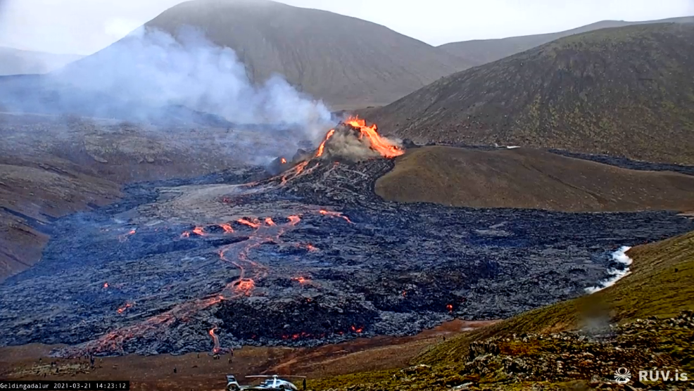
That was quite a day. After the fissure had opened early in the night, and everyone was scrambling for a view that was a bit more than a red reflection off the clouds, in the day time everything became clear. A camera was put up on just the right place, courtesy of RUV. Not even HVO managed to do it this well. The setup team even was on camera themselves, whilst they were working. The highlight was when one of the three went to his knees, it turns out not to pray he got it right, but in order to take a lava-selfie. It is almost the same thing, I guess.
We had (and have) a brilliant view of the eruption, the flowing lava, the intermittent snow, the helicopters and the small plane (presumably sampling the gas emissions), and very quickly the tourists. At one point a large group of people was standing around and doing something right at the edge of the approaching lava. They had to retreat as the lava advanced but kept doing their rituals. It appears this was a group of archeologists trying to rescue a pre-christian burial site. To ‘rescue’ means ‘to document’ to an archeologist. The burial site would have dated from the previous pghase of Reykjnes eruptions, before the year 1000. This valley was never affected but the eruptions. Now, finally, the luck of the buried people has run out. See https://twitter.com/astro_graph/status/1373596762565455875
There is a nice timelapse made by commenter astrograph99. The archeologists can be seen about 1 minute in.
https://www.youtube.com/watch?v=puSLSuIBbn4
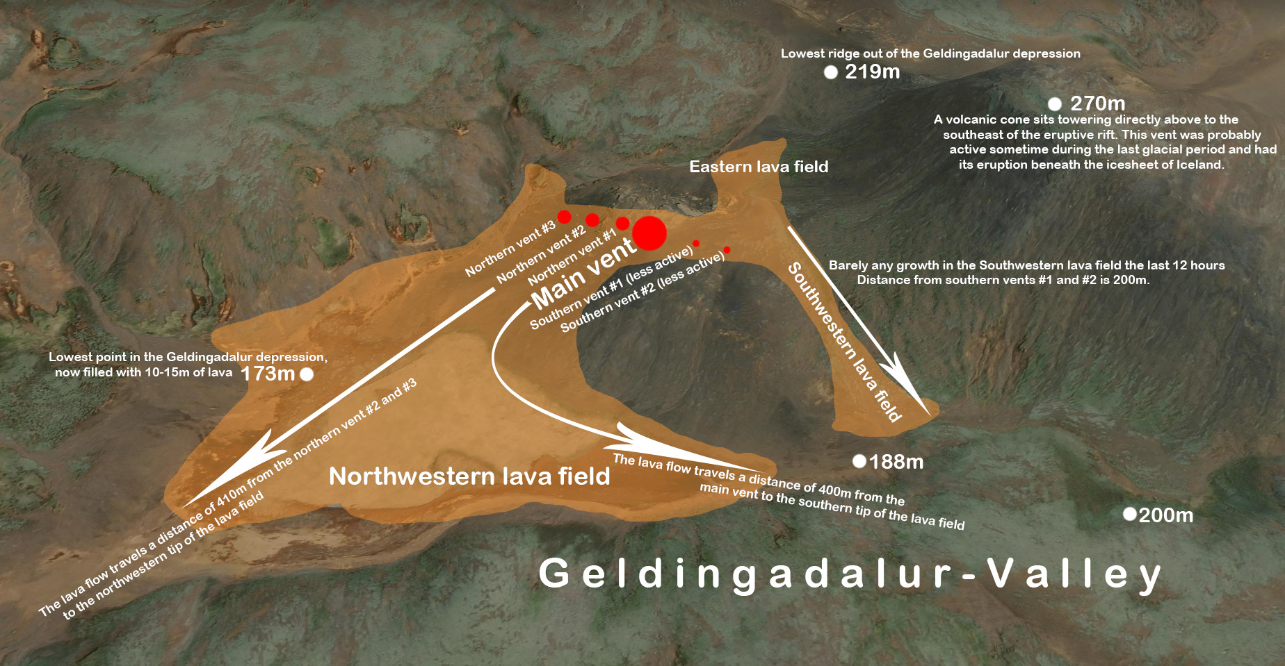
And here is a lava layout courtesy of commenter chrnesset.
Other things we learned yesterday is Motsfo likes popcorn with her lava, that Alaska is cold and the Faroer is not, and that half of Reykjavik including commenters are planning to go to eruption today. Lava to an Icelander is honey to a bee. This is about as friendly an eruption as you can get, with lava that can’t get anywhere and stays in a valley and ridges provide excellent viewpoints. The only problem is that it involves a long hike. The weather also is not particularly viewing friendly today, bit this is Iceland after all. You have to accept whatever weather is thrown at you.
Posted by Bjarki
From the map above, it seems that the lava as of last night covered some 0.1km2. Assuming an average thickness of 10 meters, gives an average eruption rate of (very roughly) 15 m3/s. This is not particularly high and it adds to the touristic quality of the eruption. A much faster eruption would be much more dangerous. (The eruption rate normally decreases after the first burst, so by now the rate may be quite a bit lower.)
The fluidity of the lava is hard to judge from video frames. At times it flows quite fast, at other times it seems more sluggish. My impression is that the magma was a bit stale, perhaps already a bit cooled during the weeks of storage in the dike. But that impression should be taken with a big grain of salt. Of course the top stuff is erupted first, and that may be the oldest which was deposited first. If this continues for a while (that is an if), the younger and hotter lava may make its way to the surface later. Wait and see.
There were perhaps 6 or 7 vents during the first day of eruption. This is common in rift eruptions. All are building spatter cones (which are prone to collapse. be careful!). Over time, you would expect that one cone will become dominant and starve the other vents of magma. At the moment, three of the vents are active.
The wind is blowing the gas towards Reykjavik: https://dispersion.vedur.is/map.html. IMO writes that “gas pollution is not expected to cause much discomfort for people except close up to the source of the eruption.” They do have a stern warning: “The area of the eruption is considered very dangerous – the eruption site can change without notice and put people at risk unexpectedly.” We recommend that people follow all advice from the local authorities (which we are not!). If you go viewing, be well prepared (don’t expect a paved path – the only pavement is hot lava), don’t expect water on tap, and stay upwind from the gas clouds. And remember White Island.
A notable change since yesterday is that there are still earthquakes in this location, but they are now deeper, at 4-6 km. The shallow earthquakes have ceased.
How much magma is there? The dike was reported to be 10 km long, 5 km deep and 1 meter wide. That makes it about 0.05 km3 (and not 0.5 as was here initially..). Much of that is not accessible to this location: magma at the tip will not easily flow back to the centre. If there is no magma re-supply, it is unlikely more than a fraction of this will erupt. However, if the entire dike erupts, at the estimated rate, that could keep the eruption going for a month. (This has been updated to fix a catastrophic math error, pointed out in the comments. )
So it is back to wait-and-see! But the seeing is mesmerising. Or even magmarising.
Albert
https://www.ruv.is/frett/2021/03/20/beint-vefstreymi-fra-eldstodvunum


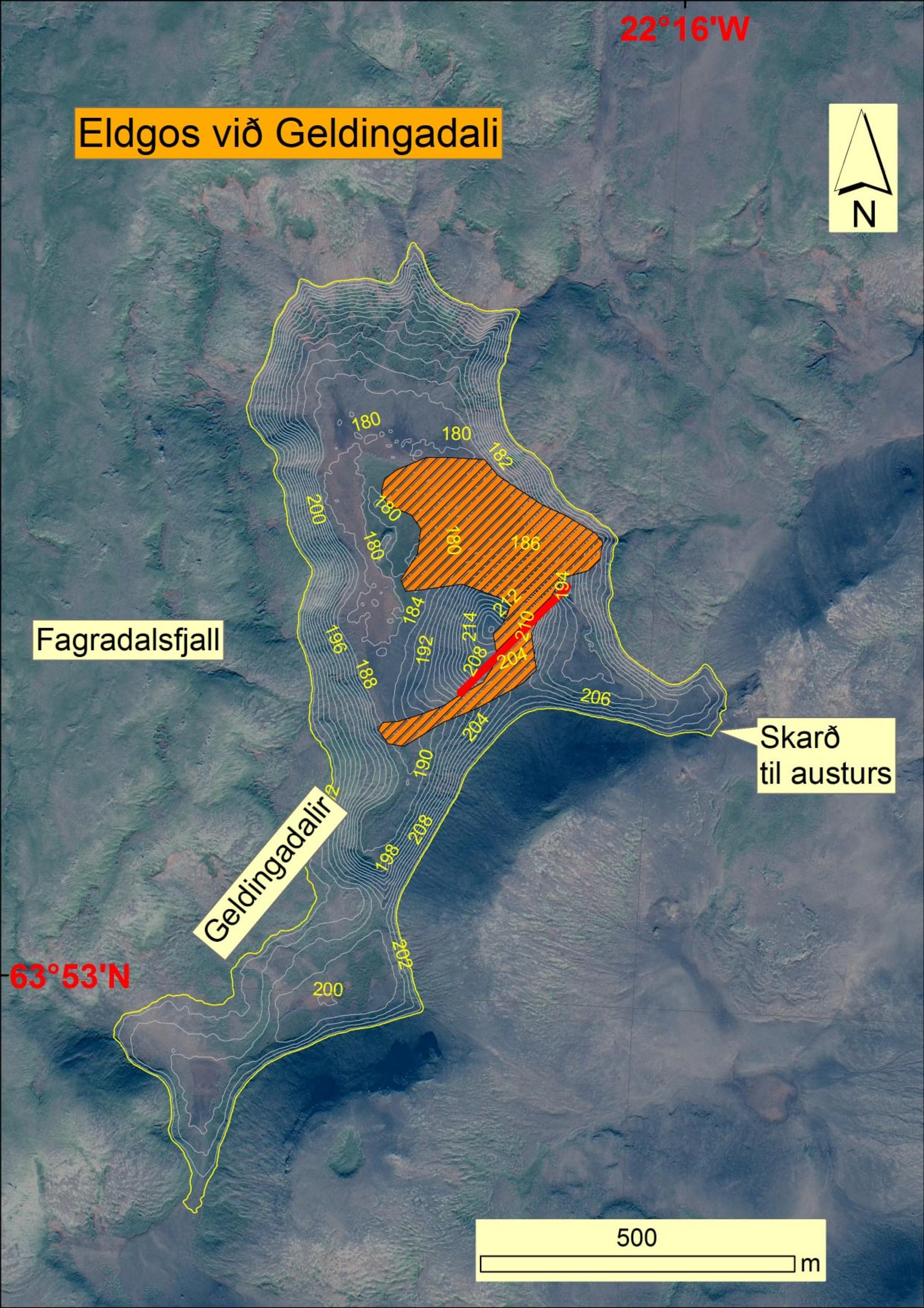
Valley 10-20 days to fill
Given the lava flow in Geldingadalur as it is now, it would take 10-20 days to fill the valley with lava. Subsequently, the lava presumably slides away from the slope, likely south of the mountain towards Niger, and then Ísólfsskáli.
This is the assessment of Magnús Tuma Guðmundsson, professor of geophysics, based on calculations published by Jóhann Helgason on social media.
“If the eruption continues for so long, it eventually comes up very much lava. There is little flow but it remains to be seen how long this lasts,” said Magnus Tumi in a conversation with mbl.is.
…
https://www.mbl.is/frettir/innlent/2021/03/21/dalurinn_10_20_daga_ad_fyllast/
Sorry, missed the new post. Here is again the interesting video if the crack that produces the white steam, on the webcam image on the right on the top. In case you asked yourself what that is all about.
https://twitter.com/VTLAB_Joel/status/1373366944699723779
That clarifies it a lot! Steam but no lava.
Could this be simply water? Its whiter than the main vent’s exhaust.
How long before that ridge where people are standing to watch gets cut off? Probably not the best of places if the cone collapses either.
Thanks for the great update. But 10 km x 5 km x 0,001 km should be 0,05 km2, not 0,5 km2…
Oops. I put in 10 meters rather than 1. Because I had the thickness of the lava field in mind at the same time.. This will require some rewriting. Or I’ll just leave it in hoping noone else will notice..
Albert, Thanks to take care of followp up.
First photo: is the police around the fissure? Is it allowed or no to go there.
Could you check the link about astrpher999.
thks
Fixed. Interesting WP feature that caused this misdirection
In that first picture? Looks like coast guard TBH, they probably helped RUV to relocate their camera when they flew in the first batch of scientists
Here’s a view of what it looks like “behind” the cones, and it is quite clear that people who go up to the vents are in no immediate danger of being cut off. Source: https://twitter.com/krjonsdottir

Good; it looked a bit ominous on the Mild cam. 🙂
Looks like the main camera is on the best side after all
Looks like the flow from the main cone has turned around completely and his heading right towards the exit of the valley!
https://twitter.com/krjonsdottir/status/1373619657022836736/photo/1
At or just before 13.30 pm there seems to be a pulse, with a left-hand side breach of the curved lava channel edge, combined with some very rapid surface overturning(?)
The weather seems to be closing in.
https://www.ruv.is/frett/2021/03/20/beint-vefstreymi-fra-borgarfjalli-ad-eldstodvunum?fbclid=IwAR1HjP9wEFNW2bLIaJQj5X96BK8NJsTadE35FC7d0OeEXDJtzzunerfxebg
Link to live – stream again
Lava production seems to have increased again. Now 9noine different overflows to the pond and a new lava tongue has created a fresh front at the bottom left hand side of the image. Main lava channel also seems a little wider.
I’ve drawn an estimated extension to the lava on the ealier image, based on the image from Kristin Jonsdottir, if the link works.
https://imgur.com/a/6Gq94DI
Some shallow quakes north east of Fagradalsfjall. Wil a new crack open up here?
Picture from 2011, pretty much the same angle as the webcam

Cool! I wonder what it’s going to look like in a month from now…
Not like that – just felt for the archaeologists rushing round collecting samples etc before the lava came in
In hindsight, it is interesting to see the small pre-existing hill of ash? where the new fissure broke out, but no one could have guessed that this was the weak area in the crust. Iceland has much to teach us.
Top down view, from Almannavörnum

Huge collapse on main come just now!
Indeed! Screenshot.
Great!
A lot of lava now! Engulfing out of the cone…
Time to get off the ridge I would say….
I have not seen anyone on the right for at least an hour now. Looks like the area was closed earlier.
Some time ago I happen to see all the folks leaving the ridge rapidly at the same time. Probably an evacuation order from authorities (or the air got bad due to the engulfing lava).
Was the authorities, there was a tweet somewhere about it
Makes sense. Folks were clearing the area around 12:27.
There’s no-one there, police already cleared the hill.
Main cone just collapsed towards the south..
Spectacular lava splash.
Cone looks really unstable now: way too steep on the LH side and activity has definitely perked-up.
Is there a chance we could get a true fountain out of this in the future, or is it probably gonna stay like this the whole time?
Either way it’s still interesting to watch. 🙂
I wonder whether a new vent could open to the right of the current vents (on the live cam) where the white smoke/steam is visible (has been there for a while). Folks are watching from the opposite side. Would match the evacuation order of the ridge.
ruv.is is making a video of the collapse event, they are asking the public if they have recordings from different angles and such. Looking forward to seeing it.
https://twitter.com/astro_graph/status/1373596762565455875
Yesterday archaeologists were trying to get as much information about the possible grave as it was swallowed by the lava. They were frantically trying to do some rescue archeology in front of an approaching wall of lava.
The first image RUV has been sent apparantly of the episode. credits Kristína Sigurðardóttur

Wow. Spectacular!
From this angle the crack which is emitting the smoke/steam is very well visible too.
it looks like the steaming crack is in the same line as the other vents, so if there is enough lava left it might turn into a vent.
https://twitter.com/subglacial/status/1373643835415396353
For those who missed it, the episode can be seen here https://www.ruv.is/frett/2021/03/21/gigbarmurinn-gefur-sig-og-ny-hraunrennslisaed-myndast
excellent… not to be missed..
Can the eruption change and become more violent?
Somewhat. New fissures can open and the fluidity of the lava may change resulting in higher fountains. Or the cone may collapse again like it did a hour ago.
But it wont suddenly switch to a different more explosive eruption type or anything like that. Just lava fountains.
The Sheriff’s Department has decided to close an area closest to the eruption crack in Geldingadalur, but the decision is based on a scientific council resolution that the large crater can smile and the lava leasing rapidly changed direction. This is reflected in the announcement on the Public Prosecution Service’s Facebook page.
Furthermore, the risk of another volcanic crack opening near the crater, which happened during the volcanic eruption in the Fifties in 2010. You can see the area that the attached image will be blocked.
The sheriff also points to the following issues regarding the dangers that may arise around the eruption sites.
New cracks can open in the immediate vicinity of the volcanoes at no notice.
Glowing lava can fall from the lava edge and rapid and sudden front-runners occur as new lava tongues break out of the lava field at high speeds that are difficult to avoid on the run.
The craters are now many metres high and can be unstable, they can break and a great and sudden lava stream from them take a new direction.
Explosions can occur as lava flows over water-capped soil and whipped lava to all eight.
The lava flows into a closed pump, and life-threatening gases can accumulate in pumps that can be fatal. The risk increases as the wind decreases.
Finally, it is pointed out that bad weather is forecast for the next 24 hours and that travellers need to be very well equipped if they are going to walk to the eruption sites. The weather gets worse through the night with sharp weather, sleet or snow.
https://www.mbl.is/frettir/innlent/2021/03/21/loka_svaedi_naest_gossprungunni/
Wise
Anyone else seeing a large body of lava creeping around from the back of the two smaller fissures to the left of centre? I’ve rewound about thirty minutes to check.
It looks like the whole of the base of the valley is now filled, except for a small area on the far right, at the base of the slope and the area nearest the camera.
https://photo.24liveblog.com/2744943423120436866/20210321153337_020883.jpeg
The area of the slope, hatched in red is also closed.
Seems after the collapse of the spatter cone the flow out of the fissure now is to the south, then turning left and comin around to the perch. The flow out of the cone to the north have dried up it seems.
Yes! I wonder if that flow will ‘push’ the more fluid perched pond lava towards the camera and cause a ‘surge?
Is already happening. On the left you can see the lava tsunami coming. It really looks like a very slow tsunami. It will spread out over the flow field, I expect. The tourists will be okay. Good thing they were evacuated from the hill before the collapse
We seem to have two overflow channels ‘crossing the streams’, holding back a huge squarish raft of solidifying lava. I get so interested in the small-scale morphology of these ephemeral features. So easy to please 😂
Special notice to Albert: it’s minus 16C this morning in Alaska…. 😉
Activity is Increasing at the main spatter cone …. watch webcam
Hey Jesper! Glad you’re watching. It’s a magnificent show.
Spatter conec and lava field of the the last 1210-1240 eruption event. Stampar lava field, Reykjanes peninsula. Very similar features as we can see right now in the Geldingadalur depression. 🙂
https://twitter.com/szharangi/status/1373662104436285443
I’ve attempted a representation of the vents and lava extent this afternoon.
https://imgur.com/a/jc8Watm
” Now, finally, the luck of the buried people has run out. ”
… or it’s a boon since their graves will be left alone once they are covered in magma.
Yes. Instead of having to choose between burial and cremation, you get both
Lava now creeping to the right behind the exclusion zone and the steaming fissure? Seems to be a glow in front of the spectators.
It’s also creeping towards the valley exit to the left of the main cone
Yes. There are several small vents there, but this is the first time you can see the lava glow from those.
Is it the vents that glows or is it just perched lava finding its way to the south?
We need another webcam to see behind the fissure hill *sighs*
I’m still very, very thankful for the one we do have, it’s great on a 52″ TV screen.
What do you guys figure, is this still VEI 1?
VEI-0
Yep, Bjarki: creeping SW, SE and North towards the camera by a circuitous route. Is there an orifice on the LH side of the cone? Sometimes lava seems to shoot out that way and there is a precariously perched block above this that must fall sooner or later. Angle of repose on this slope has improved over the last couple of hours but this block still does not look stable.
Who’s this guy..
https://imgur.com/a/2h1sq9U
More shallow quakes south of Kelir. Will there be a second eruption site there?
Last 90 minutes of the eruption…
A wall of lava approaching the helicopter. Luckily it is moving slowly. I like those timelapses.
Helicopter is on a slope…above the lava : )
It’s moved quite a bit towards the camera, since I decided I needed to do more stuff ready for my move 😛
It looks like it’s getting quite a bit more intens. or is it just the reduced daylight?
Took me a while to catch up on all the posts here. Glad the weather cleared and I get a chance to see things before it get’s too dark.
I swear to God if I track any more mafic volcanism I am going to die! Come on let have some nice dactite explosions Katla!
Katla wont do that it is mostly basaltic and its capabilities probably a bit exaggerated, if you want an Icelandic volcano to your taste better to go with Oraefajokull 🙂
Thankfully Oraefajokull is still inflating so we might still get a good eruption but could herdubreid give me a good explosive eruption? it’s a tuya after all.
In the past I have read a fascinating article by Hofsjokull on this site.
However, I wonder why I can’t find any information about the Esufjoll volcano anywhere.
It would be interesting to know if it has comparable potential with Oraefajokull’s.
A person had to skeedadle quickly out off the way there in bottom right when that little piece opened up/fell off. timestamp 18:02:10
I have seen that, looked like a pretty closed call!
Festarfjall cam shows many people on the street. Still at least 4.5km walk from there.
More on the archeology yesterday. More of a correction on the story, really
https://mobile.twitter.com/beinakerling?lang=en
360° panorama of the eruption site in Geldingadalur – taken by my lovely friend Snorri Thor
@iceland360vr
https://twitter.com/sissakristjans/status/1373670604377833472
https://twitter.com/DJCManns/status/1373706442751021063
The lava viscosity when watching the webcam… is clearly not as fluid as Vatnajökull – Trölladyngja and Kilauea. There is no smooth and even skinn on the lava channels.. it was not shiney either in daylight.
It have also trouble forming true smooth pahoehoe close to vent overflow spillovers
https://www.ruv.is/frett/2021/03/20/beint-vefstreymi-fra-eldstodvunum?fbclid=IwAR0nkXlw1eI7MtWTDimBS5QI-VgnnlRQtgBeK7338lpeN2-Tzvl6x8-_jxo