
The Fram locked in sea ice
It was June 1893, and the Fram expedition had just set off. On board the Fram were Otto Sverdrupp as captain, Fridtjof Nansen as science lead, and 11 other crew members. The goal was to reach the North Pole with the least amount of effort and the largest amount of risk. They would sail east along the coast of Siberia and let themselves be caught by the winter ice. That ice, Nansen said, would carry them with the currents to the North Pole, and on out again towards Norway. It was a voyage into the unknown, as neither the Arctic Ocean nor its currents were understood.
The entire adventure was based on the remains of a ship that had been lost off the coast of Siberia, the USS Jeanette. It had foundered in 1881, and the debris was found by Eskimos on the southwestern coast of Greenland three years later, in 1884. The expedition wanted to repeat this journey, though without the shipwreck bit. It almost worked. They reached the Laptev Sea where they became frozen in, or ‘moored in the ice’. The ice followed the general direction Nansen had predicted, but the North Pole was too difficult a target. The ship reached within 5 degrees of the pole. Nansen thought he could do better and left the ship near this point, trying to get there by dog sledge. That too was too difficult: while they traveled north the ice underneath them drifted south at almost the same speed. He and Hjalmar Johansen achieved 86 degrees latitude, but had to turn around and (as expected) failed to find the Fram again. The two men spend the winter at Franz Josef Land, where later in a complete fluke they ran into another expedition (British) who recognized Nansen – an Arctic version of the Stanley-Livingston encounter. Eventually they did reach Norway. In the mean time, the Fram had drifted almost as far north as Nansen had reached, then drifted south with the ice and reached open water near Svalbard. Nansen had arrived in Norway on 13 August 1896 – the Fram got there one week later.
In hindsight, the Fram had traveled along much of the length of the spreading centre inside the Arctic Ocean. But that only became clear a century later.

The Arctic Ocean
The arctic is a bit of a mess. This is true on several levels. As one example, the north magnetic pole has moved 10 degrees north over 30 years, from the Canadian to the Russian arctic region. (The south magnetic pole is in contrast rather stable.) We could also mention the equally rapidly changing climate, with sea ice in steep decline. There are the political battles over control of its waters and minerals, and the commercial battles as sea routes once blocked by thick ice are opening up. But this is a volcano blog and the mess referred to here is purely geological. The Arctic is an ocean that doesn’t know what to do with itself.
The Arctic Ocean is rather small, as oceans go. It has a roughly rectangular shape. The true oceanic part is very small, measuring 3000 km (from Norway to Alaska) by 2000 km (from Greenland to Siberia). The deepest parts are much smaller, covering the area north of Greenland to Alaska. The Arctic Ocean is almost entirely surrounded by continental shelfs, which become wide on the Eurasian side. Here are the Arctic Seas: the Barents Sea, the Kara Sea, the Laptev Sea (that one becomes important later on) and the East Siberian Sea. There is only one narrow gap in the continental shelfs, between Greenland and Svalbard.

Source: Martin Jakobssen et al., 1990 EOS 81, page 89-100
Any self-respecting ocean should have a mid-oceanic ridge. This is how oceans form, after all. And so the Arctic Ocean has one, but it has the slowest spreading rate of any of the oceans, so slow that just ‘slow’ doesn’t capture it: it is called ‘ultraslow’ instead.
Originally this was all continent, 700 million years ago. The line where this continent broke is still visible: it is the straight coast line from north Greenland along the Canadian archipelago, ending at the junction between Canada and Alaska. (Alaska is a later acquisition: read all about Wrangellia.) (The straight line continues under water to Norway, but in reverse.) The break-up was the biggest catastrophe life has ever seen (White Christmas). But this post is about a different catastrophe – and a different volcano.

Source: National Geographic, 1990. The faint red star show the location of the North Pole
The Gakkel Ridge
The Mid Atlantic Ridge gets a bit lost in the north. It splits into two branches beyond Iceland. The eastern branch near Norway has died. The western branch runs along Greenland, but then jumps eastward at the Jan Mayen suture zone. It continues northward from Jan Mayen, but just above the north coast of Greenland it make a sudden 90 degree turn to the west and shortly reaches the scar from the old break-up. And there the Atlantic ridge disappears.
A little further west, above Greenland, another ridge ends. It runs perpendicular to the old scar, towards Siberia, with a total length of 1800 km. This is called the Gakkel Ridge, after a Russian polar explorer who had predicted its existence. It comes to within a few degrees of the North Pole. (There are some similarities here to Fridtjof Nansen and his voyage of exploration!) The Gakkel Ridge runs so far north that google map doesn’t show this part. Neither does the USGS earthquake map, which relies on google maps. (Apple maps does show the full Gakkel Ridge, but only just.) A funny aspect is that the two ends of the Gakkel Ridge, along a nearly straight line, both point south. It makes sense on a globe but not on a flat map.
The Gakkel Ridge borders the Amundsen Basin on one side, with a depth of 4 km, and the Nansen Basin on the other side, 3.5 km deep. (The map above uses older names.) The ridge rises to 3 km depth, with the usual canyon at the centre which designates it as an actual spreading centre. The canyon is 10 km wide (again typical). The spreading rate is a rather leisurely 1.4 cm per year near Greenland, declining to half that (very leisurely) when approaching Siberia. When it reaches the Laptev Sea and the continental shelf, the spreading centre becomes obscured but continues into Siberia as a fault line which separates the Eurasian and North American plates.

Source: P. Michael et al., 2003, Nature 423, 956-961
The Gakkel Ridge has some volcanic activity. The western part (closest to Greenland) contains 5 separate volcanic ridges inside the central canyon. This zone extends over 200 km; the canyon is up to 20 km wide. It is a fairly active zone, perhaps similar to the Mid-Atlantic Ridge. Pillow basalt has been recovered from here, some quite fresh looking. At the eastern end of this segment, a number of volcanic cones have been found. The ridge is shallow in this region. This may be caused by a warmer mantle near Greenland. Is it related to the flood basalt 60 million years ago around the edges of the north Atlantic Ocean? That question is for another post.
At the end of this zone, the Gakkel Ridge suddenly deepens by 1 km. The central valley narrows to 4 km or less and is only around 200 meters deep. The valley consists of several segments, which don’t fully line up: there is some wiggle room in the Gakkel Ridge. There are few volcanic features along this segment. This 300-km long segment called (a bit awkwardly) the ‘sparsely magmatic zone’. On the western side, no basalt is found. Going east, there are a few basaltic fragments including one small cone at 13 degrees east. The spreading here is called ‘amagmatic’: rather than lavas, the bottom is mostly exposed solid mantle material, dominated by peridotites and without gabbro. About 200 km into the segment (around 20 degrees east), the rift valley is filled in by a volcanic mount, related to a much larger seamount away from the Ridge. Otherwise, there is little evidence for volcanic activity here. The mantle may just be too cold.
The third segment is the eastern volcanic zone which runs from 30 degrees to 85 degrees east. There are five separate volcanic centres here, each some tens of kilometers long. Apart from these centres, there is little evidence for activity. Overall activity is not high, but the freshest basalt was found on the easternmost centre which may have had recent activity. This same area had an earthquake swarm in April 1999. The spreading rate here is estimated at 1.1 cm/year.
The Gakkel Ridge has quite a rough structure with many individual ridges and troughs, both on the ridge and in the central valley. These are bordered by faults. This faulted structure and roughness may be typical for ultraslow spreading centres, where the crust is relatively cold. The flanks and shoulders of the ridge are more smooth, and extend about 50 km into the basins, at a fairly uniform height of a few hundred meters above the basin. The shoulder extend further into the Amundsen basin than into the Nansen basin. This is attributed to a bit of rotation around the spreading centre.
These three segments together cover only a little over half of the total Gakkel Ridge. The survey ended a little beyond the point where the Ridge gets closest to the North Pole. Beyond this points, there is earthquake activity along the Gakkel Ridge but it is much less than what is seen in the Mid Atlantic Ridge. The area falls under Russia, and in the current climate – heating up in more ways than one – scientific surveys have become more difficult to organise.
The Gakkel Ridge Caldera
It is an interesting section of the Gakkel Ridge. There is a dramatic change as the Gakkel Ridge extends towards the Laptev Sea and its continental plate. On the oceanic side there is a clear ridge with a central valley. One the other side the ridge disappears and the valley becomes much shallower and becomes a graben. When it reaches the continental shelf, the obvious signs disappear and the spreading centre becomes invisible – albeit it does continue as a fault that separates plates.

At the location of the change, the spreading centre suddenly plunges to over 5 km depth, over an elliptical area 40 km wide and 80 km long. This has been interpreted as a caldera and it therefore became known as the Gakkel Ridge Caldera, or just the Gakkel Caldera. At the floor of the caldera a 500-meter deep valley seems to continue the spreading centre.
The discovery of this caldera was announced only in 2017. The authors (A. Piskarev et al., Giant caldera in the Arctic Ocean: Evidence of the catastrophic eruptive event. Sci Rep 7, 46248 (2017). https://doi.org/10.1038/srep46248) dated the caldera to 1 million years ago. This was based on the width of the apparent spreading centre within the caldera (10 km) together with an assumed spreading rate of 1cm/yr.

Source: Piskarev et al. 2017
A caldera that size must have produced a very large amount of ejecta. The eruption would have involved 3000 km3 of magma – a Toba-like eruption, but deep under water which would have filled the Arctic Ocean with sediment. The discoverers went looking for this sediment. They found it on the Mendeleev Rise. Cores produced several thin layers with enhanced pyroxene, opaque minerals and magnetite. The last of these is magnetic (there is a clue in the name) and gives rise to a stronger magnetic susceptibility (how easily a material is magnetized). This magnetic signal stood out very clearly in five layers, each thin, dating between 700,000 and 2.5 million years ago. The dominant layer occurred at 1.09 million years ago. This same layer is found in cores some tens of kilometers away.
The paper argues that this layer and the caldera have the same age and come from the same event: a very large eruption in the depth of the Arctic. It would be the largest eruption known in the Arctic.
The Gakkel Ridge is an ultraslow spreading ridge. The authors wonder whether such rifts, which produce very little magma, could instead be associated with violent events.
It is a spectacular finding. But extraordinary claims require extraordinary evidence. How does the evidence hold up?
To Be?
Some of the arguments used in the discovery paper remained incomplete, caused by the fact that the data was not that extensive.
One issue is the lack of obvious lava flows. A hole this size would have contained a very large magma chamber. Toba, a caldera of similar size, produced lava flows that reached both coasts. But the maps of the region show no indication of this. Neither do the echosoundings, which penetrate the crust and detect the layers below, show evidence of buried lava flows.
The authors assign a VEI 8 to the event. But it cannot have been explosive. At this depth, the pressure is above the point where water can boil. Instead it forms a supercriticial fluid, intermediate between liquid and gas. It is in effect a liquid with density of 10% of that of water. This is the stuff that comes out of black smokers: a plume of black water, ascending quickly because of its low density, but not explosive. If it stays hot enough, it can reach to 1 km below sea level at which point it has to decide whether to be a gas or a liquid. It is also not clear whether pumice would form, as this requires gas bubbles. The ejecta would likely stay within the water column.
That reduces the spread of the debris considerably. The heat would generate a vertical plume but the horizontal spread is still limited by the water currents. And the Arctic Ocean is a watery dead end, a cul-de-sac. It took the Fram three years to travel with the ice from near the caldera to Svalbard, at a snail pace of 3 centimeters per second or 100 meters per hour. The currents that drive the ice will be faster than the ice itself, but this is very slow. Even if the sediment would take a week to begin to settle, it would still come down within tens of kilometers of the eruption, which would be mostly within the caldera and in its immediate environment.
The sediment layers found in the discovery paper are located on the Mendeleev Ridge, near the East Siberian Sea. This is 1000 km away from the Gakkel caldera, and it is not in the direction of the current. If the sediment reached this far, it should have been very obvious near to the caldera.
There is a final point. The identification of the content of the layer as volcanogenic came from observations elsewhere. Specifically, three similar layers have been found in the Sea of Okhotsk Sea (S. Gorbarenko et al., 2002, Marine Geology 183, 107). Those layers are attributed to eruptions in the Kuriles and Kamchatka, where the debris collected on the sea ice and dropped on the sea floor during episodes of ice melt. The ejecta themselves were rhyolitic, something that would have been unexpected for volcanism on a spreading centre. It makes one wonder whether the ancient layers found on the Mendeleev Ridge also came from Kamchatka. After all, Kamchatka is not that far from the East Siberian Sea and from there the sea ice flows in the right direction.
This leaves some questions regarding the interpretation as a supervolcanic caldera!
Or Not To Be?
The deep depression was discussed in more depth (pun intended) by A. Nikishin et al. 2018, Tectonophysics, 746, 64 where it is called the Gakkel Ridge Deep. Although they do not claim that it is a caldera, they do point out several volcanic features in and around the Deep. This includes a large seamount nearby (Trubyatchinsky Seamount), located within the Gakkel Ridge some 50 km east of the Deep, and Shaykin Hill, a smaller seamount located on the elevated rim of the Deep. Some reflecting layers in the nearby Gakkel Ridge appear to be volcanic, and may be from ejecta from one of these seamounts. There are three circular structures seen as magnetic anomalies which appear to be magmatic, two of which are located within the Deep and one on the northern flank. There are also some apparent volcanic peaks on the rim surrounding the Deep.
This shows conclusively that there is or has been volcanic activity around the Gakkel Ridge Deep, but does not elucidate whether the Deep is itself volcanic or tectonic in origin!
The sediment within the Gakkel Ridge Deep is around 300-500 meters deep, while in the surrounding rift it is around 1 km. The sediment gets deeper towards the Laptev Sea, and this appears to be the reason that the Gakkel Ridge becomes indistinct at the eastern side: it becomes buried. This sediment goes a long way back. Much of it was deposited between 20 and 50 million years ago, based on magnetic maps. The lesser depth in the Gakkel Ridge Deep therefore suggests that it is a younger structure, but not necessarily very recent.
A pillow lava dredged up from the Shaykin seamount on the northeast rim of the Deep has been accurately dated using argo isotopes (W. Jokat et al., 2019, https://agupubs.onlinelibrary.wiley.com/doi/full/10.1029/2019GC008297). It is dated to 3.65 million years. The mount is 13 km from the centre of the Gakkel Ridge, and for a spreading rate of 7 mm/yr, the mount would have formed near the centre of the spreading ridge. The composition of the lava points at a low melting fraction on the mantle, and argues against a large magma reservoir as would have been required for the explosive formation.
Jokat et al attribute the volcanism around the Deep to the presence of transverse faults, which provide pathways for the magma to come up. They assume that two of these form the boundary of the Deep along the spreading centre. Indeed, the evidence for volcanism is found mainly at either end of the Gakkel Ridge Deep. Seismic activity also suggests that there is volcanic activity at the northwestern rim, extending a few kilometers into the Deep (D. Essing et al, 2025, https://seismica.library.mcgill.ca/article/view/1381).
That is the question
The Gakkel Caldera is nowadays commonly referred to as the Gakkel Ridge Deep. This already shows the uncertainty regarding its origin. There is volcanic activity in its vicinity but it is not clear whether the level of activity is different from that elsewhere on the Ridge. The evidence for a VEI-8 sized event is lacking, but a volcanic origin of the Deep cannot be excluded.

Source: Jokat et al. 2019. ‘PS72’ is the location of Sayshin Hill
But neither can a tectonic origin. This is still little explored in the literature, but there are some pointers. The higher resolution bathymetry above shows that the Deep contains two basins, separated by a transverse ridge. One of the basins look very elongated, the other is more elliptical. (The original Gakkel Caldera combines both basins.) There are two further transverse ridges on either side of the full basin. The width the Deep is similar to that of the central valley on either side. (The higher resolution image shows no clear evidence of a central valley at the centre of the Gakkel Ridge Deep.)
This suggests that the Gakkel Ridge Deep is an intrinsic part of the spreading centre valley. The centre of the Deep is rather similar in width to the valley of the Gakkel Ridge to the northeast, just being much deeper. The transverse ridges delineate the two deep basins.

Horst and graben (source: wikipedia)
This suggests the possibility that the Gakkel Ridge Deep is a basin between the raised transverse ridges. This would be a horst-and-graben situation: inclined faults create a ‘U-V’ shape, and if the ‘’U’ part is pushed up, the ‘V’ part will sink. It is a common mechanism for the formation of basins. In the image above, the spreading centre runs along the red arrows and the faults run perpendicular to this. The faulting requires a fairly brittle crust, which is not normally found within a spreading centre. However, this one is ultraslow, with limited mantle upwelling. The crust is therefore colder than usual in such a situation. The volcanism in the region would be related to magma rising through the transverse faults.
This is far from proven, but it provides a plausible alternative to the interpretation of the Deep as a caldera. In my opinion, there is volcanism but it does not appear to be a caldera.
Rifting in the Arctic Ocean
There is still a loose end here. The Gakkel spreading centre through the Arctic Ocean is younger than the ocean itself. The ocean formed from the break along the northern edge of Canada, forming the Canada basin. Spreading here has long since ceased. The Gakkel Ridge formed later, forming a new oceanic basin along Europe and Asia and extending the original ocean. This combines the Nansen and Amundsen basins and is sometimes known as the Eurasian basin.
The fact that the Gakkel Ridge does not line up well with the North Atlantic Ridge suggests that it did not start there. In fact, the slowest part of the rift near the Laptev Sea appears to be the oldest section. The rift here developed from the continental rift cutting through Siberia. It extended into the Laptev Sea and continued its growth from there. The oldest part may be around 50 million years, before the separation between Europe and North America. It reached the western section close to Greenland within the past 20 million years, perhaps benefiting from the growing separation within the Atlantic ocean. Only at that time did the Arctic Ocean acquire its connection to the Atlantic.

Source: Anatoly Nikishin et al. 2026, Earth-Science Reviews, 279, 105525
Exploration
This formation scenario that the Gakkel Ridge traveled from the New Siberian Islands to Greenland, passing Svalbard on the way. This is the same route taken by the remains of the Jeanette, which led to the famous voyage of the Fram. Fridtjof Nansen had done more than finding a new route to the pole. He had unwittingly replayed the process of the very formation of the seas that he had wanted to explore.
In later life Fridtjof Nansen became famous for other work. He was a driving force behind the League of Nations, and won the Nobel Peace Prize for his work on helping the victims and refugees of World War I. But he is remembered most for a journey that did not reach the North Pole, but changed the way we view our world. And according to contemporary reports, the journey changed him from a somewhat arrogant young man to the compassionate leader of his later years. In the cold of the Arctic, he found his warmth. The Arctic is not just a far-away mess. It is also a very human place.

Fridtjof and Eva Nansen, 1889
Albert, August 2026
Further reading about the Gakkel Ridge:
The End of the World

Wow..I knew virtually nothing of the past geology and geologic makeup of the Arctic. Thank you!
I wonder what role that minimized coriolis forces nearer the pole plays on mantle convection currents and/or plate spreading? As mentioned, a 1cm/yr spreading rate is lower than most/all other lower-latitude spreading ridges. Maybe it’s harder for magma to ascend near the poles?
The Coriolis force is not important: it is too weak for have any effect on the high-viscosity flow of the mantle (and the force is also absent from the equator). The centrifugal force has a minor effect. Because of it, the surface gravity on the pole is about 0.5% higher than that at the equator (due to the bulging of the equator). So the ascent is just that little bit harder. But the effect is still too small to really matter. The main cause of the slow spreading is the lack of subduction zones that pull in the right direction. The force that pulls on the spreading centre is small.
And mantle upwelling maybe minior there too.. compare gakkel to reykjanes submarine ridge ( thats very slow ) looks like a superfast spreader in morphology maybe because its charged by the Iceland plume?
Iceland as a superspreader .. yes, the plume helps but the main force that determines spreading rates is still the ridge pull. The spreading rate in Iceland is not much different to that of the rest of MAR
Reykjanes Ridge in Iceland is a slow spreader but the morphology is very divergent from other slow ridges its vigourous and likley haves 10 – 20 times the eruption frequency compared to gakkel or the slow atlantic ridge futher south, and Icelands landmass is even much higher eruption frequency still
Thanks!
Writing here as newer comments jumped to Kilauea.
Very interesting piece. You wrote that the lower caldera-like zone is located at the end of the spreading ridge near the continental shelf.
This reminds me of the low-sitting Salton Sink near the end of an oceanic spreading ridge
and also of the Dead Sea, same situation. Maybe also Afar. All lower than surroundings.
Similar mechanism thinkable?
Just more water on top and harder to explore.
That is an interesting observation. The Gakkel deep is rather deeper than the other two but then, it is oceanic and the others are continental. You could speculate about spreading starting deeper down but not yet so much on the surface. That will leave a hole.
Very interesting post and, as always, very well written.
So, “to be or not to be a caldera?” – I go with your explanation for the Shakespearean conundrum!
Thanks, I remember when this came out that it seemed a bit suspect in that there could be such a large caldera on an oceanic ridge.
So much of what we know about mid-ocean ridges would indicate that large calderas simply are not possible unless there is something different or unique about that ridge (such as a ridge intersecting continental rock). Given, I recognize that when you’re given evidence to the contrary, you have to change your assumptions. But with the very thin evidence, I can’t help but think this is just a tectonic structure that happens to look caldera-like.
There is the Corbetti caldera in the East African rift, so calderas can form within spreading rifts. This must come from long distance rift eruptions, draining the magma chamber. This could also happen in oceanic rifts. Explosive eruptions seem much more difficult to do. Rift eruptions tend to involve a downhill rift – there should be a reason for the rift to form. That gradient seemed missing in the Gakkel caldera. Neither was there any evidence of the lava that would have erupted. So I was dubious. But in the end, the data decides, not our opinions.
Oh no doubt, calderas can form within spreading rifts. I would say that if anything, a rift or at least rifting type environment is almost a prerequisite for large calderas to form.
But I don’t think the crust around a mid ocean ridge would be strong enough to hold a large caldera. And even in the event that a very large magma supply could accumulate, I would still expect it to be predominantly mafic as opposed to silicic. The main difference is between that of oceanic crust and continental crust.
It’s like when Pluto got downgraded to a dwarf planet.
I for one am immensely disappointed that we don’t have a frozen deep super-caldera.
Pluto is now the second largest dwarf planet. Much better than being the bottom ranked planet!
really, you should count both the binary pair for size….
But Pluto is so much smaller than the next smallest planet, that adding Charon would not make a difference. Pluto is 25 times less massive than Mercury, the smallest planet. (Mercury is itself half the mass of Mars.) Eris, the most massive dwarf, is 25% more massive than Pluto (Pluto is the largest dwarf planet by radius but not by mass.) Charon adds 10% to the mass of Pluto. The difference with Mercury is enormous – a moon is not going to help.
Charon also does not have enough mass to push the Pluto/Charon system above Eris. And Eris has a sizeable moon itself, although not as large as Charon.
If Pluto had been discovered say in terms 1990’s, it would never have been classified as a planet. The original classification was based a bit on wishful thinking.
We now require that a planet is the dominant object in its orbit, and has cleared the orbit of competition. Pluto has not done that.
Pluto is no intrest for me: I woud be much more attracted by a Super Earth say 6 Earth masses of terestrial materials for obivious reasons
Pluto is not large enough for me Albert
But Io works well too 🌋
Europe’s sub-plates moved from the southern hemisphere to the present position over ~500 Million years.
The Gakkel Ridge is a divergent plate boundary crossing the North Pole, so this opposes the northern movement of Europe. What force is stronger?
Wrong way to look at it. The spreading centres are not stationary. They move with the rest of the plates. There are only two plates involved here, the Eurasian one and the North American one. The MAR, the Gakkel Ridge and its extension across Siberia separate the two. Both plates are moving, and they are also moving apart. The spreading rise itself will be moving with the average velocity of the two plates.
Normally, we pick one plate as a frame of reference and give the velocities relative to that. Which plate depends on where you are ..
This is same ‘Super Slo-Mo’ spreading zone which extends via Lake Baikal to the hyper-complex Japanese region ? Parts do look more like ‘Pull Apart’ basins than ‘active’ rifting !!
No, Lake Baikal is not a spreading fault but is being pulled apart by some rotation of the continental block, caused by pressure from India. The spreading zone that continuous into Siberia runs along the Chersky mountains. much further east. There is a little bit about it in an old post (one of my favourite but quite non-volcanic): https://www.volcanocafe.org/terra-incognito-the-verkhoyansk-mountains/
https://volcano.si.edu/volcano.cfm?vn=377020
lava flows on Gakkel Ridge
Moderately strong (5.7) earthquake near Krakatau today:
https://earthquake.usgs.gov/earthquakes/eventpage/us6000tmlu/executive
So the Gakkel Ridge is older than Iceland, although the plume of Iceland existed before in Greenland. The plume of Iceland reached the current position ~16.5 million years ago according to Wikipedia.
Are we able to observe ordinary eruptions along the oceanic ridges? They happen kilometers below the sea surface. Is it still possible to observe f.e. tremor of an eruption down there?
https://www.instagram.com/reel/DKFuCVZo3rm/
Yes its been seen by submarines but taken nearly 60 years of submarine exploration to see that here is flowing EPR lava. Here is an active slow pillow lava flow, a typical slow slow water flow. A faster submarine sheet lava flow is a true lava tsunami which have not been seen in action yet
Todays lava lake image from Nyiramuragira the lava poor is clearly visible
https://browser.dataspace.copernicus.eu/?zoom=17&lat=-1.41028&lng=29.20584&themeId=DEFAULT-THEME&visualizationUrl=U2FsdGVkX19n3qEgbDLwh3O2VrZQvIq4Q5CSVYWLatq4NSB1UV7qSrH5IWZTv%2FbFdesSqc7dNg9N2g2%2FCyVRBRDuc35ZjVYZuYwbj2xWmeo3Hq5ZpJs%2FJQPpujSzDBP9&datasetId=S2_L2A_CDAS&fromTime=2026-08-21T00%3A00%3A00.000Z&toTime=2026-08-21T23%3A59%3A59.999Z&layerId=1_TRUE_COLOR&demSource3D=%22MAPZEN%22&cloudCoverage=30&dateMode=SINGLE
https://browser.dataspace.copernicus.eu/?zoom=16&lat=-1.41134&lng=29.20265&themeId=DEFAULT-THEME&visualizationUrl=U2FsdGVkX188WPHtYoC7O7gEhpUn2hgfxmcZpO4k4O%2B5La2iD0XLWmwKX5%2FD91BDP6hdL%2BoBiYnPuIWsBHa%2Fq0MSyfKRK3BKEQOgMIoGHNutYjB4nr0PjAKsTZjpYJ1a&datasetId=S2_L2A_CDAS&fromTime=2026-08-21T00%3A00%3A00.000Z&toTime=2026-08-21T23%3A59%3A59.999Z&layerId=1_TRUE_COLOR&demSource3D=%22MAPZEN%22&cloudCoverage=30&dateMode=SINGLE
Pahoehoe lava flows keeps moving down Nyiramuragiras side
https://browser.dataspace.copernicus.eu/?zoom=15&lat=-1.43894&lng=29.18166&themeId=DEFAULT-THEME&visualizationUrl=U2FsdGVkX1%2B13vV1apNjOqxETj4Gs%2BhEhNDcWdF%2FssHTOeHvNqu2H9sBm6dyf78pROTjiq0fyfjLcxeyl1m0IkIaybqs9%2BrjOeiF84cnILM%2FJW3dImny7W%2B1cuoTniWr&datasetId=S2_L2A_CDAS&fromTime=2026-08-21T00%3A00%3A00.000Z&toTime=2026-08-21T23%3A59%3A59.999Z&layerId=6-SWIR&demSource3D=%22MAPZEN%22&cloudCoverage=30&dateMode=SINGLE
Lava pool clearly visible
The run-up to the next Kilauea episode may have begun. But it is at least a day away, I think.
Comparing pre eruption tilt with the last three episodes, this could escalate quickly. Spattering is now visible.
South vent with regular lava spattering, the new northern vent with occasional spattering, faint glow from the old northern vent. Probably slow lava masses moving over the conduit, my hunch is that the stable configuration with two lava conduits helps Kilaulea to keep up the regular quasi-periodic behaviour.
And thanks Albert for the article and showing me a feature I’ve never heard of.
The northern vent did two lava dome fountain mini episodes between 6 and 8 HST. Sooner or later one of these lava domes will escalate into the actual episode 54 = LIV (Roman number).
All in all the 14 episodes of 2026 have had an output of 90.4 mio m³. It is likely that in September the year will reach to a volume of 0.1 km³.
2025 the eruption did 0.1375 km³ until the end of August. 2025 was more productive in the first eight months.
v2 camera has a good view
Now the major lava dome fountain of E 54 has begun and is growing: https://www.youtube.com/watch?v=f9-oSpYpubg
Preview to the next episode by Big Island News Video: https://www.youtube.com/watch?v=5wzH213lQdI
Yes, we are off
Sadly now all over.
Really nice if someone could post one pic each episode for those of us who log in once a day.
As requested. Sadly it was overnight for us, so missed the main event
Reykjanes Ridge near Eldey with a serious Earthquake Swarm: https://en.vedur.is/earthquakes-and-volcanism/earthquakes/
Earthquakes also spread in the whole western region until Ljosufjöll and Hekla. Are they wrongly localized by the computer system or is the region really above-average active now?
That is a decent swarm. There have been several in this region recently, but this looks bigger. All earthquakes in unexpected regions are misplaced. I think the system can’t cope well with such a dense swarm. If the quakes come too close, it is difficult to disentangle which shake on which seismograph belongs to which event, and if it is assigned wrong the quake ends up way off – often midway between two seismographs. In such cases it is better to start with the assumption that all quakes formed in the sample location and try to fit as many of the shakes as possible. That leaves a few that don’t fit, and those are the distant ones. But that can be more difficult to implement.
Now, after some days the wrong locations are deleted.
However, we’re now in the longest volcanic break in Iceland since Fagrdalsfjall 2021. It is now ~12 months after the last eruption in August 2025. The three Fagradalsfjall eruptions had an interval of 11 months.
Can we guess that the current probability for an eruption on Svartsengi is higher than on any other Icelandic volcano?
Some of the stars are still in unlikely locations
Average time between eruptions in Iceland is 3-5 years.
I agree, those remaing stars look like they’re off. Now, the events are no longer visible in the public drumplots, so it’s not possible to check those again, but I’m pretty sure they looked like they were all coming from Eldey, like I said in the comment below.
It should be mentioned that those drumplots are very low resolution and don’t give away all the details. If Icelandic experts with access to the full datasets have manually reviewed the data and placed those stars in those strange spots, then that should normally weigh heavier than my personal amateur opinion, but here I think someone made a mistake. The one listed near Straumsvik is 13 seconds after the M4.1 outside Eldey. That’s about the propagation time for S waves between those two locations and a clear indicator that those two could be the same event.
Yes, the other locations are misplaced.
Some of them have now been cleaned up and removed, but if you look at the drumplots for stations near those that remain, you can only see waveforms that are obviously distant. A good way to tell is to look for double peaks. Those are P and S wave arrivals from the same event. At distant locations they may be separated enough to look like two separate events, but then it’s still easy to see that all blips come in pairs that are separated at exactly the travel time difference for P and S waves originating from Eldey.
There is a 400 km wide caldera on this planet.
Proof? My feelings and the voices in my head?
Kilauea is foutaining now.
The episode continued the trend of increasing tilt at the start, but the amount of decline of the tilt during the episode is continuing to decrease.
Here is a good summary with a spectacular photo: https://www.bigislandvideonews.com/2026/08/25/high-lava-fountains-erupt-at-kilauea-ashfall-forecast-for-ka%ca%bbu/?fbclid=IwY2xjawT7hllwZG9mBWV4dG4DYWVtAjEwAGJyaWQRMGdvUThVZDFMbjlPaGZvUmpzcnRjBmFwcF9pZBAyMjIwMzkxNzg4MjAwODkyAAEe56_TRFiFsqnL0Bq36RRCekg-hoOX8Hwqutp6tTnHOGXfvYxZC1_2j_mVQYo_aem_pId_QSGdFtMxu93EQNCYqQ
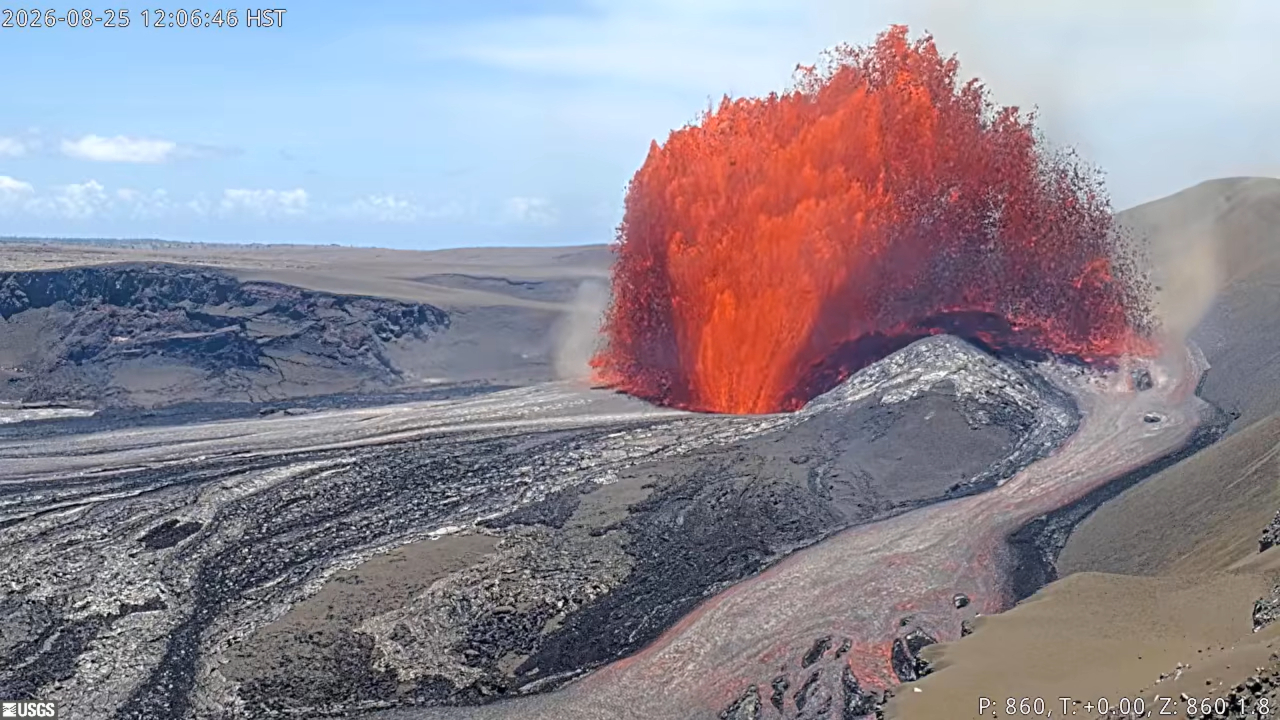
The lava fountain was 150m high, but the base of the fountain has grown with the number of episodes. Continuous lava fountaining lasted for nine hours. E53 and E54 lasted longer than E49 to E52.
Same height as previous ones 150 meters tall
This video catched the sound of the eruption. It’s a good opportunity to hear the lava fountain:
https://www.youtube.com/watch?v=WCM91e92SEc
Both the video and photos shows that the lava shield has formed an actual summit. By eye-view I’d estimate that the peak of the temporary shield volcano has reached the altitude of the caldera rim.
many thanks to you and albert, appreciated!
I woud like to write a whole article series ( many of these ) on diffirent types of mid ocean ridges according to spreading rates and explain their diffirent volcanic morphology and plumbing. I wants also to write another series on diffirent types of eruptions and submarine lava flow types and structures on these ocean ridges and how the works ( internet haves very few good sources of information )
But there is so much to talk about!
This is pretty much a months to over a year long project but it woud be fun to show! an ultrafast spreading ridge axial segment is basicaly a superlong superflat mauna loa while an ultraslow spreading ridge segment is a giant rugged rift valley… they are as diffirent as a whale is compared to a daschound in morphology and behaviour
I woud like to explore the fastest parts of EPR with more submarines a nearly 20 cm a year rate it probaly erupts small areas of fast submarine sheet flood lavas as often as every 2 to 4 years per 100 km segment and each segment may erupt smalll ammounts of lava once a year at some local area.
Gakkel Ridge for comparison On average, roughly 9,000 to 100,000 years pass between major volcanic eruptions at any single specific segment along the Gakkel Ridge which is a major difference to fastest portions of EPR
New post is up. Before the Nepal disaster was Kazbek – a lesson from the past
https://www.volcanocafe.org/the-kazbek-disaster-a-cryoplastic-debris-flow-2/