
Beneath this featureless volcanic wasteland runs one of the longest lava tubes in the world – reaching all the way from Monte Corona in the distance to way out under the sea.
Lanzarote ranks as one of the most obviously volcanic places on the planet. The island is covered with craters, cones and lava fields. The dry and frost-free climate means that volcanic features weather only slowly, and vegetation has had a hard time gaining any meaningful foothold on the land. The cones and lava go back a long way. But not as long as the island itself.
Around 15.5 million years ago the island became the second of the Canaries to emerge (some time after neighbouring Fuerteventura, although geologically they are essentially the same structure, along the east Canary ridge). Drift pioneer Alfred Wegener visited Lanzarote in 1912 months after he had first presented his theory of continental drift.
In the first but long lasting phase of eruptions at Lanzarote, two main shield volcanoes formed, which grew together to form the elongated island. This growth phase lasted for more than 10 million years. Still, it ended several million years ago and both volcanoes are now deeply eroded. The southern volcano is known as Los Ajaches: it is still recognisable as a rise in the land. The northern one is Famara, also recognisable but it is now partly under the sea. Coastal erosion has considerably reduced the old volcano.

After the end, a new phase of volcanism started up. It seems to have focussed on the area and fissures between the two extinct volcanoes. Why this happened is unclear. This phase is still in progress. Unexpectedly and disastrously, a major volcanic episode began in 1730, when a fissure opened up in the west of the island. Over the next 6 years, the Timanfaya eruption produced over 10 eruption centers. 23% of the island was covered under fresh lava and spatter. And this had not been a volcanic waste land: before the eruption it was a fertile albeit dry region, where the ancient lava had turned to soil. Once the eruption started, the lava, ash and some pyroclastics quickly made the region unproductive and the island uninhabitable.
Timanfaya
Earthquakes came first. Precursory seismic unrest may have begun as early as 1726. The eruption began on 1 September 1730 and ended on 16 April 1736 (after 2055 days). (Some argue that it ended a year earlier, in 1735.)
The initial phase of the eruption involved three eruption centers: Caldera de los Cuervos (1–19 September 1730), Caldera de Santa Catalina (10–31 October 1730), and Pico Partido (10 October 1730 to January 1731). These vents produced extensive lava flow fields that destroyed several villages on their way to the northwest coast. Explosive activity produced thick layers of lapilli and ash, damaging roofs and ruining farmland. Ash reached across Lanzarote and Fuerteventura. After January 1731, Pico Partido stopped and the eruption ceased for several weeks. But then it restarted at Montañas del Señalo, not far from Pico Partido. Between March and July 1731 there were four episodes, during which lava travelled a short distance to the north and southwest.
At the end of June 1731, phase 3 started with a sudden shift of activity, 12 kilometers towards the west coast. The first activity here was under water: historical accounts describe explosions at the coast and numerous dead fish on the shore. Shortly after this, Volcán El Quemado began to form, a small elongated vent 1 km from the coast. The activity now migrated back east, forming Montaña Rajada and four closely-spaced cinder cones called Calderas Quemadas. They produced large lava flows which reached the coast.
At this point, the people began to leave the island, and reports of the eruption become scarce. Contemporary information on the eruption becomes very scarce. Phase 4 began in early 1732, with explosions which formed Montañas del Fuego, a large and complex cluster of overlapping cinder cones. The eruption may have continued at this location until early 1736. It produced abundant lavas that flowed towards the northwest and southwest.

Montañas del Fuego (https://www.heatheronhertravels.com)
The fifth and last eruptive phase occurred 5 km further east, at Montaña de las Nueces and Montaña Colorada. When it began is not known. An impressive pāhoehoe lava flow came from Montaña de las Nueces, and reached the coast near the town of Arrecife to the east. This was reported to have happened between mid March and early April 1736. But a contemporary visitor, Dávila y Cárdenas reports that lava flows emitted from this vent already threatened the port by 1733. Eruption rates normally decline late in an eruption, and the earlier time seems therefore plausible.
The final act of the Timanfaya eruption was at Montaña Colorada. It was brief, lasting perhaps for only two weeks, and ended on 16 April 1736. It produced a smaller lava flow lava, and a lapilli field on its flank.
The final act was not the end. A brief eruption in 1824 formed three further cinder cones, over a 14 km rift within the Timanfaya region. Seismicity began 11 years earlier, and increased in the months leading up to eruption. After two days of subterranean noises, ground cracking and gas emissions, an eruption started in the morning of 31 July. Mild Strombolian activity produced a small lava flow, and build the Tao cone. The eruption had ceased by 2 am on 1 August, but gas emissions at the vent and seismicity continued.
Unusually for the Canary island, for several days over the next 2 months, hydrothermal activity produced erupted brackish water. On 29 September, a larger eruption began which Volcán Nuevo del Fuego. Lava flows reached the coast on 3 October. The eruption intensity increased, but on 4 October it suddenly diminished and had stopped by the next day. A new phase of seismic swarms and subterranean noises came, leading to an explosion at Tinguatón on October 16 followed by lava flows. This lasted only one day, but it was followed by hydrothermal explosions with geyser-like jets. These lasted a week and formed a series of aligned, deep and narrow pits on the Tinguatón crater floor. The 1824 eruption ended on October 24.

The image shows the extent of the 1730-1736 lava field (in yellow) and that of the subsequent 1824 eruption. The volume of the lava was around 3 km3, not counting the part of the lava flow below the sea. It buried 26 settlements, covered much of the agricultural land, and let to mass migration. Two years into the eruption, the island became largely deserted. Few records exist of the next 4 years of the eruption.

The lava flows, with the cinder cones delineating the 14-km long rift. The rift extends further, as there were reports also of submarine activity. This is thought to be the second largest basaltic flow of the past 500 years, after Laki.
The massive eruptions of 1730-36 and 1824 were the first on the island for many millennia. Were they the last throes of the building of a volcanic island? Or a sign of things to come? And where had the lava come from? There was (and is) no indication for a magma reservoir underneath this part of the island. It had come out of nowhere.
Gravity measurements have since shown that there are three main regions of high density material underneath Lanzarote. Two of these are underneath the ancient volcanoes, and probably represent the (solidified) old magma feeds. The third region is underneath the central-east part of the island. The rift of Timanfaya points at this area. The gravity measurement also showed that underneath the Timanfaya area, at 1 kilometer depth, there is a layer of low density material, possibly sedimentary or ancient pyroclastics. But no magma conduit was seen.
The most plausible source of the Timanfaya lava is around Las Brenas, which is the southern main region of high density crust, and is located southeast of Timanfaya. This is also the old heart of the long-extinct Los Ajaches volcano. This high density region shows some branching into the right direction. The idea is that magma followed this old path up to the surface, but could not erupt due to the high density cap. However, while branching northeastward, it found the area of low density (sedimentary?) crust. This provided an accessible pathway, and this formed the erupting rift. This sequence of events describes the eruption itself, but it does not explain why new magma suddenly entered such an old volcano.
But it had happened before.
Corona volcanic group
In many Spanish-speaking regions, lava fields may be known locally as ‘malpaís’, literally the ‘badlands’. One of the largest areas of malpaís in Lanzarote is found at the northeastern tip of the island, a designated ‘Monumento Natural’. The Malpaís de la Corona was produced by the Corona volcanic group, dominated by 600-meter tall Monte Corona itself and incorporating the smaller, older volcanoes of La Quemada and Los Helechos. These two volcanoes grew out of the Miocene shield volcano of Famara, with Los Helechos dating to about 91,000 years ago.

Monte Corona looming large over its badlands. To the left is Volcán La Quemada, long predating Corona. The past was condemned to repeat itself.
Corona provided the most recent significant eruption on the island prior to the 1730-36 and 1824 events. In the past (still repeated in tourist brochures) the eruption was dated to only 4,000 to 5,000 years old, based largely on the apparently ‘young’ condition of the lava field.
However, Lanzarote has very slow weathering, as it is so dry. The condition of the lava does not exclude an older age. Argon (Ar39/Ar40) dating has found that Corona was active around 21,000 ± 6,500 years ago. That puts it within the last glacial maximum, at a time when sea levels were much lower. We will come back to this.
Although the Corona lava flow seems similar to the 1730-1736 Timanfaya flows, this eruption was not fed from the same magma source. Whereas the Timanfaya magma came from the southern old Los Ajaches volcano, Corona is on the northern old volcano, Famara, and must have been fed from its ancient conduit. Mysteries here run deep.
The Corona eruption left us a large cone and crater. The hill is 609 meters at its highest point, with a slight collapse on one side. The lava flows went into several directions. To the west, it is seen at the spectacular Famara cliffs. To the east, it formed a wide and extensive lava field flowing to to the sea. At this time the sea was much lower, and the shore was 15 km beyond the current coastline. The flows (‘coladas’) that we see nowadays are just the remnants of a much larger area. Surface erosion may be limited, but sea erosion has been much more significant. The sea has removed much of the lava, both by the large rise in sea level and by coastal erosion. There may have been more vents than we have found, long lost to the sea.

The Famara cliffs, formed by sea erosion. The Corona lava flow is at the top.
In addition to the initial explosive and cone-building activity, three separate flows from Corona have been identified. The first two erupted over the top of the much older flows from Volcán Los Helechos to the south. The third and largest flow went over the the lava field of Volcán La Quemada to the north. The last flow formed an a’a landscape, indicating that this lava was more viscous.
The Corona tube
Within the Corona ‘coladas’ is one of the many natural wonders of Lanzarote: a lava tube that extends from the base of Monte Corona to well beyond the current coastline. Nearly 8 km long, it is the world’s 15th (some say 16th) longest lava tube known.

Location of the Corona lava tube
The lava tube formed during the first, effusive phase of the Corona eruption, when low-viscosity pahoehoe basalt. It came from a lateral vent on the eastern side of the Corona cone, which also formed hornitos. The tube went roughly ESE, toward the sea.
Underneath the Corona lava flow is a layer of lapilli, which came from the initial explosive eruption. This layer itself lies above the older lava from Volcán Los Helechos. The Corona lava appears to have followed a gully in the underlying Los Helechos lava. The walls of the tunnel walls show how successive pulses of pahoehoe lava formed a channel, raised the sides and eventually formed a roof. Subsequent lavas buried the tunnel further.

The smooth walls of the tunnel were formed by the flowing lava
Close to the sea, the tunnel reached the edge of the Los Helechos lava where the new lava cascaded down. Here the tunnel formed as many as three chambers, at varying depths, by internal collapses, false floors and subsequent re-routing. The tube ends abruptly in a large chamber that is 64 metres below current sea level.
On the surface above the Corona tube are 21 ‘jameos’, the local name for a hole in the ground where the roof of the tunnel has collapsed. The jameos provide access to the tunnel, which is typically 20 metres wide, although up to 30 metres in some sections.
The lava tube likely originally ended where it met the sea. Studies of similar activity in Hawaii and elsewhere in the Canaries suggest that it is highly unlikely that the tube would have continued forming after this point. Typically, water quickly cools the lava and a ‘lava delta’ forms. These do not contain lava tubes, but grow on the surface. There is evidence of some explosive activity at the seaward end of the tunnel, consistent with hot lava mixing with seawater.
But although the tube must have formed above water, the final section is now under water. This fits with the older age, indicating that the lave tube dates from a time when the sea level was much lower than it is now. At the time, the sea level was as much as 100 meter below current levels. As the vast ice-caps retreated, raising the levels of the ocean and inundating the tunnel. Sea water penetrated as far as an area known as the Cueva de los Lagos (‘cave of the lakes’), around 600 metres inland from the current coastline. During the reshaping of the Jameos del Agua in the 1960s/70s the tunnel was artificially cut off from the sea. Water that remains in the caves upstream comes from rainwater seepage.
Tunnel of Atlantis
A tunnel leading from the jameo closest to the sea provides access to the underwater portion of the tunnel. The 1618 metres of the tube that is now under the sea is known as the Túnel de la Atlántida (‘Tunnel of Atlantis’). It is the longest underwater volcanic tube known. It was not until 1988 that cave-divers completed its exploration. Features of this section are the Montaña de Arena, an 11-metre high mound of sand that has accumulated underneath a small hole in the roof of the tunnel, and the Lago Escondido, an air chamber that can only be reached through the submerged portion.
The Túnel de la Atlántida has formed a number of pools and ponds along its length. These are called anchialine pools: small bodies of water underground connected to the ocean, often tidal and brackish. The majority of them are in Hawai’i. A unique set of small creatures mqke their home in such environments. The Atlantida pools are devoid of light, apart from
the Jameos del Agua lagoon which is located (as the name implies) below an opening. The animals here are small, blind and lack any pigmentation. Seventy-seven species have been discovered in the anchialine sections of the cave, including the galatheid crab (Munidopsis polymorpha – it is actually a kind of lobster) that has become the symbol of the Jameos del Agua. While this tiny white creature is the public ‘face’ of the caves, it is two recently discovered species of remipede (Speleonectes ondinae and atlantida) that are scientifically the most noteworthy, as such crustaceans had previously not been found on the eastern coasts of the Atlantic.

Galatheid crabs thrive in the partly lit lagoon at Jameos del Agua. The blind creatures grow to about 2 cm in length.
Humans and the tube
With the jameos providing ready access to the tube, humans have used sections of the tunnel for many centuries. Its constant temperature of 19°C made it a natural place for food storage, and it became an important place of refuge.
During the 16th and 17th centuries Lanzarote was repeatedly attacked by pirates and slave-traders, mostly from North Africa, but also from northern Europe. Such attacks ranged from small raids to full-scale invasions. Sir Walter Raleigh destroyed the main port at Arrecife, and shortly after an army of Berber pirates pillaged the island.
During such raids – there were many of these – the jameos of the Corona tube became a natural hiding place for the people, in particular the caves known as Cueva de los Verdes. Their use as hiding places was first recorded in the 1590 writings of an Italian engineer, Leonardo Torrini, who noted that the caves also provided an underground route to the sea should the need arise to escape by boat.
Tourist attractions

The Cueva de los Verdes. In times past islanders used the caves to shelter from pirate attacks .
Despite its name, the ‘Cave of the Greens’ is not green at all, being named instead after the Verde family that owned the land. During the more peaceful times (at least for the island) of the 19th Century the cave became a popular destination for wealthy European travellers visiting the Canaries. In the early 1960s, as Lanzarote began to grow in popularity as a package holiday destination, the local authorities decided to develop the Cueva de los Verdes as the island’s first major tourist attraction. It opened in February 1964.
Cavers had opened up more than 4 km of the tube, of which around 1 km was prepared for casual visitors, featuring up to three levels in one section. Walkways and atmospheric lighting were devised and installed by architect Jesús Soto, who also designed the Ruta de los Volcanes, the road that now carries the tour buses through Timanfaya national park.
Although there are some still ponds in the cave system, it is largely dry. The Cueva de los Verdes were not formed by water, and they lack the familiar stalactites and stalagmites. However, in many places there are small ‘lavacicles’ formed by the solidification of lava that has spattered on to, and dripped from, the roof of the tube. In some parts of the tube they form pointed rows known as ‘diente de tiburón’ – ‘shark’s teeth’.

Lava spattered on to the roof of the tube forms ‘lavacicles’
Throughout the tube there has been considerable collapse of roof material, there are many areas where the original smooth tube wall is obvious, with a rougher, flat floor where the lava stream has solidified in situ.
Manrique’s masterpiece
Downstream of the Cueva de los Verdes, shortly before the tube dips under the sea, are the Jameos del Agua. Along with the Timanfaya volcanoes, this location has become the island’s most popular visitor attraction. Two jameos – Chico and Grande – are linked by a lagoon partially lit by a small opening in the chamber roof. Here the famous white crabs can be seen in a part-natural, part-sculpted setting created by the vision of Cesar Manrique.

A soothing oasis in an ancient lavascape
In the Jameo Grande a typically ‘Manrique-esque’ lava garden has been created, with a serene blue-water pool. Although it is Manrique who is credited with the concept of Jameos del Agua, apparently it was Soto who oversaw much of the detailed design and the day-to-day work. The first section was opened in 1966, and further areas were opened up progressively until 1977.
Beyond the Jameo Grande, in the tube itself, is a subterranean auditorium used for concerts (a smaller auditorium is also to be found in Cueva de los Verdes). Above the jameos is a visitor centre complex, including the highly recommended ‘Casa de los Volcanos’, a volcanological research and educational establishment.

The lava tube Café at Jameos del Agua – almost as good as Volcano Cafe. But 20,000 years too late
UKVIGGEN / Albert
This post was published by UKVIGGEN on Volcanocafe in 2012, based on a visit to the area. UKVIGGEN kindly gave permission to repost. Compared to the original the text was edited, a section on the Timanfaya eruption was included and some information was added throughout the post. The description of Timanfaya given here is based on Marc-Antoine Longpré and Alicia Felpeto, Journal of Volcanology and Geothermal Research, 419 (2021): Historical volcanism in the Canary Islands. (not public)
References:
La Erupción y el tubo volcanico del Volcán Corona – J.C. Carracedo, B. Singer, B. Jicha, H. Guillou, E. Rodriguéz Badiola, J. Meco, F.J. Pérez Torrado, D. Gimeno, S. Socorro, A. Láinez 2003 (in Spanish)
The Corona lave tube, Lanzarote: geology, habitat diversity and biogeography – Horst Wilkens, Thomas M. Iliffe, Pedro Oromí, Alejandro Martínez, Terence N. Tysall, Stefan Koenemann 2009
Good background reading:
The 1730-36 eruption of Lanzarote, Canary Islands: a long, high-magnitude basaltic fissure eruption – J.C. Carracedo, E. Rodriguéz Badiola, V. Soler 1992 (paywalled)


Great article! Congratulations
https://twitter.com/volcanodiscover/status/1451864178453590018
#Etna #volcano (Italy): violent eruptive episode, parts of SE crater collapse into dangerous pyroclastic flows – A strong paroxysm is in progress at the volcano. As suspected already last night by the presence of intermittent stromb…
https://twitter.com/ita_dc/status/1451861635484766211
From our observation point of the eruption of #LaPalma from Tajuya, we can see the emission of streams further west of the secondary cone.
The dynamics are changing and will have to be evaluated with more data throughout the day.
https://twitter.com/RTVCes/status/1451872810654130181
Still a very nice post after nearly ten years. With some additions about Timanfaya probably a bit better than then.
About a forth of the island was obviously covered by Timanfaya’s lava. This is like all of Ireland in comparison to Great Britain. It’s a lot.
The landscape is amazing, the Manrique place much too touristic. I was there for two days from Fuerteventura. Fuerteventura is instead a very sandy place. It is a good place though as beaches are impeccable and there is a ferry in the North to Lanzarote and one in the South to Gran Canaria, so all three islands on the Canary Rift can be seen in one vacation, and day trips are possible.
The mountains in GC, from an older volcano, are also impressive, and Las Palmas is a very pretty town in the centre with old houses from colonial times.
For (hobby-)geologists and dragons a very interesting destination with good weather most of the year, around 13 hours of daylight in summer, around 11 in winter. Scandinavians go mostly in winter.
Every now and then though there is wind with sand from the Sahara.
It seems the Timanfaya eruptions took place in two primary phases. The first was when the first eruptions happened, all in 1730, and these eruptions were fast and erupted very alkaline lava not unlike what we see at Nyiragongo in both composition and viscosity. It was basically a curatin of fire except the eruptions were not on fissures, more single vents. These vents and short fissures were pretty random but generally follow a northwest line. It seems to have begun at Cuerva de los Cuervos, moved to Caldera de St Catalina and Pico Partido, then to Mazo cone which was the most violent and shortest lived, and then back to Pico Partido before stopping.
When eruptions resumed near Pico Partido the style was not as fast but the eruption was pretty much continuous, and lava was much less alkaline, ranging from transitional alkali olivine basalt up to tholeiitic MORB basalt. The eruptions after this even going into the ocean all follow a narrow rift, and the eruption rate was generally much lower but very persistent. Despite following a line though it was also not a fissure, it seems only one small area was ever active at a given time, giving the illusion of a fissure eruption. It also seems like the eruption ended with a firework show, Montana Colorada didnt make a massive flow field but constructed the biggest cone of the whole eruption in only 2 weeks. Fountains 700-1000 meters high must have been involved in its construction.
The fast initial eruptions of alkaline lava would suggest a magma chamber existed in some form, not a huge one but something. The fact a magma chamber like this was not seen today probably just means refill times for such chambers are very long, much more than on La palma for example, and possibly this is why there is so far between eruptions here. The rift in the years after is decompression melting of the mantle, a slower process but one which has higher degrees of partial melting. This I think was a secondary effect of the first eruptions. Why this didnt happen for Monte Corona I guess might just be the location, weaker crust perhaps.
Lanzarote is definitely a place that needs a few more posts to its name, such a unique place, an ancient island but still with life in it. The ocean inbetween it and Fuerteventura is quite shallow too and was land in the last ice age, perhaps one day an eruption will link them again, many millennia from now (at least if sea level rise is not to extreme anyway)
Very good post 🙂
When I first read the expression “shallow ocean” a few y ago I first thought that you can walk in there 😉
Don’t forget the water geysers. There was interaction between the flowing magma underground and (probably) the sediment. It is not inconceivable that moisture pockets allowed the magma to reach the surface in some locations. As to magma chambers, these would not have emptied completely, and they would still be hot now. That was not seen. This eruption was 3 times the size of Holuhraun. A significant magma source was needed
It was 3x the volume of Holuhraun but also 10x as long, the effusion rate averaged out was around 30 m3/s, so higher than a typical shield but not extreme. Likely it was a lot more variable but it was overall a different sort of eruption, it was more like a fast version of Pu’u O’o than it was a flood lava eruption. 30 m3/s is at a high end but I think extreme decompression melting could manage this, and as long as the rift was active this could sustain.
I imagine magma collecting at the base of the crust for millennia between events, maybe not as a chamber but diffused, before moving up. That path could well have been less than vertical. But the eruptions after 1730 were different from the first flows, so it cant be explained with single sources waning. I imagine the mechanism at work to be very similar to what we saw at Fagradalsfjall, a deep origin setting off a longer episode.
A Sentinel image from a week ago, in a version that is supposed to show the urban areas but instead shows the devastation. Also note the ash cloud
Powerful eruption at Etna, pyroclastic flows, ash to 7.5 km (24 600 feet) a.s.l., Italy
https://twitter.com/involcan/status/1451907672412934145
Lava overflow
https://twitter.com/involcan/status/1451906187620929541
4.9 mbLg SW VILLA DE MAZO.ILP
2021/10/23 15:34:49
S
38
Do we know when the predecessors to the 1736 eruption in the south/central island occurred? When did the ~5ish rows of cones near and mixed in with those from that eruption get created? It looks very much like the 1730-1736 eruption was not unique, just the most recent, looking at the topography in that part of the island.
I wake up from my sleep to find that shortly after I went to bed that the #3 cone collapsed upon itself and then lava gushed around including trying to go down the western side. It will be interesting to see what happens today or rather this evening for La Palma since it is 6 pm there now.
A photo this morning from El Galeon confirms that there are indeed 5 vents, with one sporadically erupting Strombolian fashion. https://drive.google.com/file/d/1gpXQUodNnXQc-OFDz_RElaju1zWbj5Fs/view?usp=sharing.
https://twitter.com/lcgeography/status/1451817480977006593 clearly shows this
Interesting 3d map of the earthquakes, and a clear delineation between the deep quakes (37 km) and the shallower ones (10-13 km) is seen https://twitter.com/x_y_es/status/1451960784884539393
Are they sills in the upper section? As a none expert, I am guessing they are. Perhaps there is a smooth conduit from the lower to the upper?
I’d be interested in what you know. Thanks!
the positioning of the quakes on only certain levels is almost certainly due to the data itself not the actual emplacement of the quakes. I believe that the depth has been round off and we see this artifact. (I wish that it could have been avoided, as the deeper quake data looks okay)
Thank you!
Lava boats crumbling apart as they plunge down the lava rapids. Video taken this morning I believe https://twitter.com/Javiocc/status/1451957864587792387
amazing
Crikey! That’s impressive. Thanks for the video link.
https://youtu.be/SrEBy4MTZM8
Afar coastal stream #3. 19.52 timestamp the camera pans to the volcano for a great lava view behind the northerly coastal crater.
Lapalma. Live from ocean, new lava going south:
New videos
What an impressive eruption!
https://en.vedur.is/volcanoes/fagradalsfjall-eruption/real-time-data/ GPS data shows that the deformation in the land is apparently permanent after some type of crustal intrusion of magma. Apparently there is both an elastic and inelastic change which occurred, mostly inelastic it appears.
Can we safely assume the same for La Palma, that the land deformation is basically permanent? I am speaking particularly of LP03 and LP04 GPS stations.
I think so, deformation on el hierro stayed as +25cm upwards after the eruption and swarms, we would probably see someting similar in la palma
Yes the intrusion stays underground, the deformation is permanent. An intrusion can inflate or deflate but normally then don’t disappear, in most cases at least. The intrusion may rapidly freeze into rock if its shallow and this rock won’t go anywhere of course.
Thank you Héctor Sacristán and Charly91 for your reply. This answers something which I have wondered about, and makes it clear why geologists and volcanologists are not relying on the deformation as a predictive signal of eruption dynamics. It is clear that they rely on monitoring SO2 emissions as a clear indicator of eruption strength.
One question I’ve got is how deformation and SO2 emission changes are related here, over the last week ign report small regional deflation, which would imply less magma pressure in the system, however today they reported an increase in SO2 to 30000+ tonnes (from 4000/7000 last week) which would imply more magma and more pressure down there.
Incredible photo…
https://twitter.com/VolcansCanarias/status/1452004253116080137
https://twitter.com/involcan/status/1451997909839405057
You can clearly see all 5 vents here. I wonder if the lava flow will migrate to the southmost 3 vents as the eruption continues to change?
Look at the last few images in the Hotel El Galeon stills: https://eruption.acme.to/slideshow.php?getcam=hotelelgaleon#images-200. These show the new flow to the south of the La Palma volcano, but are quite overexposed (time: 23-10-2021 20:57:05).
Yikes, that looks like a lot of lava ready to come down, and kind of answered my previous question thanks for the post.
https://twitter.com/Ayozaurus/status/1452002565068050432/photo/2 from the glow in the Hotel El Galeon photo, it would appear that the #2 vent (from the south) is emitting the most lava (for the two lobes) ?
Superb article – brought back memories of a tour we once had in the caves.
Lava keeps flowing under the delta some of the images from underwater
https://twitter.com/IEOoceanografia/status/1451244285618266122
Lava lake at Kilauea has reached the lowest collapse block, not overflowed it yet but level. Still a ways to go but the fact it has got this far in a year is impressive. The eruption shows no signs of stopping or slowing down either, even with all the vents submerged in the lake.
What are your thoughts on the proposed identification of the 1808 mystery eruption?
https://youtu.be/VwRe3iaMQ7E
Apologies if this has already been discussed!
I saw this earlier and was thinking of asking the same thing.
Thanks for posting this, as the video just got posted 7 hrs ago and already has 15,402 views. The author might be right.
Interesting! And it looks like the author has done his homework. I guess the video only hints at the work the author put into researching the mystery eruption. Nice one.
Thank you for bringing it to our attention.
The way to conclusively settle this, is to submarine down to the volcano and extract the ash, then compare the spectrographic analysis with the ash from the Antartica cores and see if they match.
Interesting video, it could very well be one of the calderas in Tonga. But there are 20+ large submarine calderas in Tonga that could have been responsible, and there is very little known about any of them, so it might take a while to find the one. If the eruption came from one of Tonga’s submarine calderas it might have taken place in a remote location in the middle of the ocean and easily gone unnoticed. However the particular candidate shown in the video is near the island of Tongatapu which was the seat of the Tonga Empire and I’m not so convinced that it could have gone unnoticed.
Another other possible area is Vanuatu, but the only large caldera there that could fit is Kuwae, which has been dated to 1452. I don’t think there is any good candidate in the Solomon Islands. And finally the Bismark Arc near Papua Nueva Guinea is well studied, so that if the 1808 eruption had taken place there we would probably know. When taking all this together Tonga does look like the most reasonable place to search for the mystery eruption.
A reasonable location but I have doubts about this particular one. The size that is given (30-50 km3) is too large for the 1808 event: we are looking from something half the size or smaller. It must have been at or near the surface – not sure how deep this is. And an eruption this size so close to Tonga would have left us stories.
Difficult to pin down which one in this location, there are so many. Monowai seamount has nested calderas but not sure of age or if it’s too far south (kermadec arc). This area is prone to large melt – some plate tearing going on and louisville ridge subduction. Found a nice looking example at around 15S 174W. Is bougainville or new britain too far away to be responsible?
He’s done a lot of research. I wonder if the oral histories from the region might mention something? A massive eruption plume won’t have gone unnoticed.
It requires the evidence of a major eruption 200 years ago. Just stating it without refs is insufficient.
https://twitter.com/involcan/status/1452188308596002821
Footage taken from the Dos Pinos neighborhood (Los Llanos de Aridane) at 9.00 a.m. (Canarian hour) #LaPalma
https://twitter.com/involcan/status/1452183421166538761
Very nice article!
I’ve been to Lanzarote once, and there is still heat in the Timanfaya park, enough to BBQ and light a fork of hay (touristic show).
I think, that back when I had been there, I only had noted the unusual length of the Timanfaya eruption, and that it hadn’t been too long since then.
In my thoughts, I had wished the same would happen while being there on vacation, because I really wanted to see some spectacular fireworks, but quickly had I come to my own conclusion that this volcano must be extinct now and there isn’t going to be any “armageddon”.
All the while reading about Fagradalsfjall and watching it do it’s thing, I never lost a thought about the Canary Islands being (still) volcanic. After all there was only Timanfaya, and Lanzarote for that matter, and Hawaii was the most interesting anyways, albeit all but inaccessible to Europeans, and now Fagradalsfjall had been taking place for quite some while.
The Canary Islands didn’t exist in my mind any longer, although I knew that there were more than just Lanzarote.
In fact, it was not until someone here on VC mentioned earlier eruptions of La Palma that I awoke and noticed that the Canary Islands are all but extinct.
But this happened so recently that I’m still sort of trying to digest what is currently taking place.
What I then got for “small boring basanite eruption” finished it off.
While by now (thanks @ all 🙂 ) I have learned that this is still a tiny eruption compared to others, never would I have expected this eruption on La Palma be even remotely comparable to our friend Fagradalsfjall.
(And even now, there is still smoke and noises in La Palma 😮 )
Still absolutely stomped and word-less.
La Palma now is much bigger than Fagradalsfjall, it has exceeded it in volume in a 6th of the time. if the eruption began now it would be the second shortest eruption, but largest volume by far in the recorded history of La Palma. I also expect it is the second biggest eruption in the Canary Islands in millennia, behind Timanfaya. I dont know if there is an official number under a day old but the stream from AfarTV has got a crude volume counter, based on effusion rate of 66 m3/s, it is currently 0.2 km3. The combined volume of both the 1949 and 1971 eruptions is 0.09 km3, so this is twice as big as the two previous eruption combined in the same time period. The biggest older eruption I can find a number for is that in 1677, at a maximum of 0.12 km3 in 65 days. So this is really something on a whole new level…
It seems that this eruption really is bucking the trend, the eruption rate is much higher than its predecessors and magma seems to be coming from a deep reservoir as the magma still is not the olivine rich basantite that characterised the majority of lava before. This means the eruption is probably going to go on as long as that magma chamber exists, and because it is not just a simple gravity drain that chamber is not going to destroy the volcano in the process of draining. This eruption has still got a long way to go, and could be huge, perhaps not too different to Timanfaya…
I believe El Hierro 2011 was a larger in term of lava volume, but again it was 5 months this one has emitted about half the volume in 1/5 of the time, i didnt expect such an enrgetic eruption I expected a Teneguia 2.0
GVP has the El Hierro volcano at 0.15 km3, so I think it is now overtaken, the eruption on La Palma is now at least higher than that and probably around 0.2 m3.
final figure seems to be around 329millio m3 according to the IEO, sadly couldnt find the original source,
https://elpais.com/sociedad/2013/01/08/actualidad/1357651248_660977.html
So Tajogaite is about 2/3 the way there in 1/5 the time.
Do you still believe that we haven’t got olivine now?
The eruption has been going for so long now, and there have been multiple comments about “the fresh stuff” erupting now.
And it is flowing quite a bit judging by the videos Luis has posted…
Apologies, I have asked my question bit in a harsh way 😮
I was asking more like whether you have evidence that it is not the “real” fresh stuff yet 🙂
Have not seen anything about more olivine in the magma, and it is still saying the eruption is from a deep chamber. Unless that last statement is not true the lava is currently tephrite, if you get tephrite with olivine in it that is basantite, which is what most other eruptions here erupted. Basantite is pretty much the same as picrite basalt except the melt is alkaline not tholeiitic, at least what I can gather. Probably is a result of dredging up a lot of olivine from the deep parts of the volcano, at least that is how most picrite basalt is created in Hawaii and Iceland.
This composition probably means other eruptions were fed from more direct deep intrusions, where this time an actual magma chamber has gotten involved.
Thanks for your statement. So the lava might become even more fluid then?
Which of the two magma chambers are they saying the lava comes from?
I heard somewhere the eruption end is supposed to be close if the deeper chamber (the 35 km one) has kind of depressurized.
Shortly after, the shallow one will get no more feed and the eruption starves.
So you (and others) take it that the deep chamber will be replenished then, from > 40 km, it will refill the shallow chamber with the olivine and then erupt it, right?
Shame on me for my questions, just eager to know =D
Kilauea summit vent has sprung a leak, theres now a new fast moving lava flow going around the south edge of the lava lake, while the original flow inside the con looks unchanged. No change on the deformation either, which is interesting, though it has only just happened within the last 20 min so could be delayed.
There was an earthquake around 12 km deep under the summit a few days ago, only one quake but it is pretty rare to see them in that location. Maybe there is a surge of magma.
Still peanuts compared to IO
Woud Earth even be habitable If it was that tidaly heated? Perhaps the volcanism woud release so much CO2 that rainfall and biological activity coud not scrub it away in time ..
Venus became a hellhouse because it became too hot for rain and without rainfall, the volcanic CO2 coud not be scrubbed away in weathering. On Venus all volcanic CO2 stays in the atmosphere.
In december 2023 Juno will begin its close flybys to IO: and we will get the first closeup images in over 20 years. The lava lakes will be the same as today, But the sillicate lava flows and pyroclastic deposits will be very diffrent now after 20 years after Galileo. IO may produce 600 km3 of basaltic lava every year, that yeilds around 12 000 km3 of basaltic lava since Galileo last visited!
IO is a fantastic moon
https://m.youtube.com/watch?v=LILMhg2Vvy4
https://m.youtube.com/watch?v=oHpxCGeXU3c
IO also haves some serious lava fountains …
The tephra gas plumes can reach 400 km tall and 1200 km wide
The sillicate lava fountains itself may reach 15 km tall during violent sulfur gas rich basalt eruptions. Pillan Patera and Surt haves insane lava fountains.
Sulfur gas expands alot in IO s basaltic magmas the vaccum drives gas nucleation like crazy. Like mentos in coke really is in IO s conduits. That drives serious lava fountains.
Any VEI8 fountain events on IO?
VEI 6 basaltic plinians seems to happen perhaps every week on IO : D
If Io was the size of the earth it wouldnt really get heated, unless all of the other moons were proportionally sized too because they prevent Io from circularizing its orbit. Replace it with the Earth and our planet would throw the other moons around like it was playing with them. It is easy to forget that our planet is as massive as every other solid thing in the solar system combined, with only Venus being anywhere comparable. Earth is actually too massive to be a moon of any planet except Jupiter, all the others the barycenter would be outside of the primary (Saturn actually I am not sure but definitely Uranus or Neptune), so would be a double planet.
A tidally heated Earth though might just melt, the heat wouldnt escape as easily, and gravity would keep a thick atmosphere. Many massive planets, even terrestrial ones, probably melt themselves. I have seen a study that carbon planets (which are probably very common) will over the course of their early evolution almost invariably form a diamond mantle and thin silicate crust from water reacting with silicon carbide the planet is naturally made of, and the planet will basically be a molten hell planet forever because plate tectonics is impossible and the core heat will transmit directly to the upper mantle because diamond is so thermally conductive. Even a rogue carbon planet or one sitting in its stars oort cloud in the deep freezer of space would be as hot as a small star for billions of years.
Yes Earth is the most massive terestrial planet in our solar system: and its why it became habitable too with active geology and magnetic field
Earth is quite heavy: yet ”not much” larger than Mars or Mercury
Chad coud it be because Earth haves the largest iron core of the solid planets?
Earths large core gives it a much higher density than the other Bodies? Perhaps Earths core is larger and heavier than whats typical of an Earth mass planet?
But I know that the variations of Earth exoplanets and Super Earths are endless .. 🙂
Not much larger than the other Terestrial planets around us. But I guess there is alot more stuff .. thats crammed into our Earth than in Mars for example. Earth is 10 X mars weight, yet less than half Mars size
Also strange that Earth did not become a Super Earth
Super Earths are perhaps the most common planet in the universe ..
Perhaps the Sun ate too much of the planetary disk in the hadean .. as well as Jupiter preventing Earth to become a Super Earth
Planets around red dwarfs and superearths look more common because planets around red dwarfs are easier to detect than planets around other types of stars, as well that red dwarfs are indeed more common. Secondly, superearths are easier to detect than smaller planets, so we don’t know that for certain. I doubt we would have discovered Earth by now even if we were 50 lightyears away from Earth. Actually only Jupiter probably would have been discovered and even that is not certain, because of Jupiter’s relatively long journey around the Sun, and while transitioning also probably being smaller due to relative size and the distance.
The fact that our Earth orbits the Sun and not a red dwarf can also probably be explained that it might be easier to develop life and stable conditions around our Sun instead of a red dwarf, as well that planetary systems might be more compact, closer to their Star (with different types of radiation and solar flames: red dwarfs are thought to be more volatile), and higher chance of tidally locked planets around their stars.
It is also uncertain how such a Superearth would look like, and whether life conditions would be better there than here, about the same or less. But I think their frequency is overestimated as larger planets are easier to detect, and because we exactly look for a planet like Earth.
Secondly, I wonder how many Super Earths will inevitably end up inhabitable or be more like Venus and Mars. If we found Mars from a 10 lightyear distance, it would probably be considered habitable as well from that distance. In fact, it is more better located in the habitable zone than Earth itself is. When looking for habitable planets, one must also consider that habitable zones are not stationary, but evolve.
Chad Its also strange that Earth ended up with souch a relativly large sun ..
Most habitable exoplanets orbits tiny tiny red dwarf stars.. like TRAPPIST system
Earth coud have ended up with a Red Dwarf too as sun
I dont think there is anything particularly weird about any individual planet in our solar system, except Earth has got life. What seems to be weird is how big our solar system is, with 8 planets. Only one other star has got so many. The physical size is huge too, Mercury would be an outer planet in most systems, and Neptune is way out there.
Super Earths are unlikely to be the most common either, same with hot Jupiter’s, those are just easy to find but big things are a single object made of a lot of matter, where statistically making lots of small things with the same amount of matter is more likely. The most common planets will be small, but those are hard to find. Hot Jupiter’s also probably destroy their solar systems, so to get a system like ours intact is probably not so common unless multiple giant planets form.
Red dwarfs are dangerous, most are highly active with extreme flares that would kill anything on a planet around them, and this includes TRAPPIST-1. Habitable planets will also invariably be tidally locked. F type stars a bit bigger than the sun are the calmest, but also wont live long enough for the life experiment to take place, only a billion years or so. So the Sun is actually pretty good, a star a bit smaller might be perfect, living longer.
Shpuld say we have only discovered one other star with 8 planets, and a few with 7. But systems this big are very rare, less than 10 in several thousand.
If we looked from a 50 lightyear distance at this star: Mercury and Mars would have never been found at this point. They’re simply too small. Venus and Earth is also a stretch, Venus probably would have been discovered before Earth would (same size, closer to the Sun, rotates faster around the Sun). Jupiter is also somewhat of a stretch, because a year lasts 12 years (the distance is quite far away), and the other gas planets are further away, and would look like a smaller dot relative to our Sun. On top of that, the light our Sun emits is a lot larger than the light of a red dwarf, while the relative size of planets rotating around a red dwarf we’ve discovered are usually a lot larger (because they’re easier to discover).
The reason we’ve not found (except for 1) a planetary system with 8 planets is because we don’t have the technology, are not looking for it or not looking good enough. Simple. It’s way too early to draw such conclusions.
So I absolutely disagree with saying that large / big systems are much rarer.
Like, have we ever found a planet that is as far away from it’s star as Jupiter is, let alone: Saturn/Uranus/Neptune.
I think there might have been a few. A few.
This image clearly shows that we don’t have the technology yet, and that instead of 8 planets… there is a possibility if we lived on a planet 50 lightyears away, we would have found exactly ZERO exoplanets on this star.
Loki Patera really seems to be a lava sea acually .. because the surface never really cools down competely after hot new crust resurfacing wave spread over the entire surface. Thats in line with a giant lava lake. And Lokis crust is quite thin despite its size of the lake. Loki is IO s largest thermal emission spot. But Pele Patera is the most Intense
Perhaps its a direct hole into IO s underground magma ocean ..
If Tidal heating gets more intense .. the whole moon may turn into a magma ocean.
There are sourely exoplanets that are 10 times more tidaly heated than IO is .. then You gets pretty much a lava lake planet ( which IO almost is )
Is it possible to tidaly heat a planet until its 100% molten? Like a lava lake ball?
Souch a imaginary tidaly heated lava lake planet .. woud probaly look like a grey shiney ball from orbit .. with a global thermal emission, crust foundering woud happen globaly over it. An enormous ammount of energy is needed to tidaly heat an object until it becomes like that
Earth and the Moon looked like that during hadean.
The lava blob world woud probaly be very dark in direct sunlight, because of its crust, it woud be an extremely smooth object too!
And IO is smooth too as its surface is plated lava flows
The Volcano has been a earthquake spike on the last ours. Not sure, but if more earthquakes coming, that can convert on a very active day.
Other point, form a hour previously, I have follow a litle white smoke plume on the north volcano flank. I expected the has only a wildfire, no a new vent

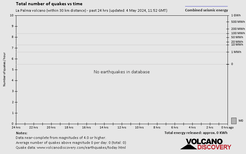
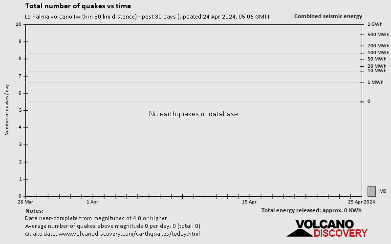
These graphs are clearly incorrectly labelled.
The ‘combined seismic energy) must by definition continually increase.
I would suggest its actually power averaged over some time period (unspecified).
https://twitter.com/ElTimeLaPalma/status/1452195410441875459
The new threat of the La Palma volcano; a stream running down the southern slope of the cone fed by a mouth that until yesterday had only released pyroclasts. Walk towards the urban nucleus of Corazoncillo and you could reach the Las Manchas cemetery
Tremor has raising from some hours ago.
And quakes too… more than 70 quakes today.
Does anyone have reliable information on the alleged new southern lava flow in La Palma?
The allegued shouthern lava flow has been explored by involcan
https://twitter.com/involcan/status/1452281652303077385
Pevolca today report talk about them and talk about move to corazoncillo, on the south side of first south lava flow.
Thx. It doesn’t appear on the maps yet (Copernicus, OSM, lapalma.maps.arcgis.com, info.igme.es).
https://twitter.com/involcan/status/1452281652303077385
New footage at 3.15 p.m. (Canarian time) of the new lava flow that advances towards the south #lapalma
The tremor actually…. that has raising to a level near to the first weeks

https://twitter.com/ita_dc/status/1452311245441339397
Right now in the #LaPalma eruption the secondary cone could be generating a lava lake.
That can be dangerous, the main cone has no stable.
Yes, very dangerous!
Have you noticed that the highest elevated earthquakes at Keilir now are in the range of 1-2km of depth. It seems like the potential new area is in the middle of the plain between Keillir and Fagradalsfjell
I noticed. But I didn’t dare mentioning it…
Something is surely coming up! I don’t think we have seen the last of this system.
Copernicus show the south lava arm.
https://twitter.com/CopernicusEMS/status/1452309377965252616
https://twitter.com/112canarias/status/1452301282119667727
I think the southern flow is not on that map, Luis.
“I may have just solved one of geology’s greatest open mysteries. In 1808, a massive volcanic eruption occurred which lowered temperatures around the planet. Yet, seemingly no one noticed the eruption although many felt its effects. This video makes the case for the volcano of origin being a specific unnamed submarine volcano located off the coast of Tonga. It has clearly produced a major explosive eruption in the last 250 years.”
https://www.youtube.com/watch?v=VwRe3iaMQ7E
I have a request for a new Volcanocafe article, to try to solve those mysteries. Beginning with spreading knowledge about the 1808 mystery eruption, so that someone does some research paper on that volcano. The other one i would like an article about is the 425BC mystery eruption, since no-one seems even to be aware that there is one mystery eruption in 425BC.
You could also just make a post about “mystery eruptions” and the existence of it, and identifying such ones (with maybe explaining how some mysteries are solved like the Samalas one).
From volcano edu
A large submarine volcano rises to within 65 m of the ocean surface west of Tongatapu Island. The volcano was informally named Volcano 1 by the scientists on the bathymetric survey that mapped it in 2003. The summit of the andesitic-to-dacitic seamount is cut by a large 7 x 4.5 km wide caldera, with two young scoria cones forming the high point. A chain of explosion craters up to 100 m deep cut the flank of one of the scoria cones, and thick deposits of ash and scoria blanket the caldera floor nearby. The lack of organic sediments between volcaniclastic deposits exposed in one portion of the caldera wall suggest it was constructed within the past 200 years. Diffuse low-temperature hydrothermal vents and vigorous gas discharge occurs near the explosion craters.
Here is a start
https://www.volcanocafe.org/1809-the-missing-volcano/
I think this is the crater he means. Do you think this is in terms of size a possibility?
It is too far south, Lakigigar.
He actually meant the one near the top of the image. There are is a pair of calderas visible left of Tonga, the northern of the two is the volcano mentioned in the video. It is surrounded by a field of concentric dunes which is characteristic of large ignimbrite eruptions. So it certainly had a giant explosive eruption at some point, but when? and did it manage to rise into the atmosphere?
I confuse this crater with another one, i’m sorry. Yes it’s the one on the top.
Albert says they would have realized in Tonga in 1808, and I believe it as well.
Besides you wouldn’t see something like a red glow in the South-West in Bogotá from Tonga on the other side.
I believe Reventador (Albert in VC link) an Ecuador in general (possibly including Galápagos) is the suspect to look at.
Nevertheless this proves that science is work in progress, so other mystery volcanoes will be found.
But sometimes I have the impression that the size of the Pacific Ocean is slightly underestimated.
But Kuwae was never a proven culprit. Some things don’t fit. So what about 1465?
Also, is a date known for the Tofua caldera?
New lava fisure form on the main volcano cone.

The other fisures has making a flooding.
Big lava flooding now!
https://twitter.com/involcan/status/1452318837974654986
Picture of the eruption at 17.45 (Canarian time) from Dos Pinos (Los Llanos de Aridane)
More fisures…. that turning dangerous

Expected that has not a new flank colapse

Two mores….

The seismic activity has on maximun.

https://twitter.com/ita_dc/status/1452321099975430152
Big earthquake…
Yes it seems a M4 more shallow quake…
No big (I was thinking 5+)
4.2 mbLg NE FUENCALIENTE DE LA PALMA.IL 2021/10/24 17:15:16 18 +info
4.3 mbLg NE FUENCALIENTE DE LA PALMA.IL
2021/10/24 17:15:17
10
That is taking more force. Look the north velt and the new velts, a good lava flooding has moving.

Sorry by the continue posting, but the activity has very frenetic.

As Angel mentioned above Copernicus has the new lava stream on its latest satellite image and map. Here is a section of it, turned by 180 degrees. This way one also get’s a good impression of the vent chain. North is to downwards on this picture (so the lave flows to the right and Cumbra Viejo is to the left).
Also found two other craters in the Tonga area. One south of Tofua caldera. And one much further to the south than the possible source of the 1808 eruption (there are multiple craters on that image) buried under water, some of them possibly being prehistoric (and actually quite far away from land, but to the south of Tonga’s most southern islands. I do not know whether there is coverage of those craters or whether higher-resulotion images of those are available?
The first is Feinga Seamount
But the second doesn’t seem to be covered on Volcanodiscovery, a smaller volcano just to the south however is covered, so if you change to sat, than you can see the crater as well, to the north of this unnamed volcano.
https://www.volcanodiscovery.com/25-177-unnamed.html
https://vents-data.interridge.org/ventfield/tonga-arc-volcano-18
The second one is known as Tonga arc volcano 18, but i can’t find anything useful on it. There is not even description of the volcano, just that it is still active geothermically. Otherwise no information to be found on it.
Tonga if FULL of calderas. The Tonga-Kermadec arc is perhaps the largest concentration of volcanic calderas in the planet. I have counted around 20 large calderas but there are possibly more. Some of the partly subaerial calderas are studied, for example Macauley collapsed 6000 years before present, Raoul at 2200 BP. and Tofua 1000 BP. However most are very little known, unnamed, and some are not even included in the Smithsonian volcano catalogue.
Question is whether submarine calderas erupt onto the atmosphere or if the material stays in the ocean. This could determine if there is a global impact on climate or not.
Shield volcano on IO s South pole
This Ionian volcano is as Big as Hawaii and many dark basaltic flows have flowed. Looks like ring fault eruptions or an overflowing lava lake formed this. But looks alot like a Galapagos shield
https://photojournal.jpl.nasa.gov/catalog/PIA02280
This volcano is currently looking extremely mentally fragile. Every few nanoseconds a fundamental change. Wonder what comes next….
So y’all be nice to it, lest something really bad happens :/
If Stromboli, which is permanently active at that, was that interesting I would’ve watched life stream more than 20 minutes, and would have traveled there at least once.