
After Iceland, there was La Palma. It could have been the Azores, of course. There are more than just two volcanic archipelagos and islands in our youngest ocean, the Atlantic Ocean. But it was La Palma. Could we have seen it coming? Eruptions at La Palma are about ten times less frequent than at Iceland, perhaps two or three times per century. Still, it would happen eventually. And to put it into perspective, the chances of an eruption in La Palma were much higher than one in Reykjanes.

Image source : Twitter @jonni_walker
The eruption began on Sunday 19 Sept, at 3:12pm, with a small bang. As is common in La Palma eruptions, the dike which had reached close to the surface was contained by the older lava flows above. Eventually the pressure reached breaking point, an explosion occurred which blew out the old lava (the brown clouds), and an opening was made for the new lava to come out. It happened on the west facing slope of the Cumbre Vieja volcano where two fissures formed, each about 200 meters long. At peak there were 11 vents in action but one vent became dominant. (Steam is apparently still rising from other vents though.) A common aspect of La Palma eruptions is that the vents form near the cones of previous eruptions, possibly because the ground there is easier to break through. This eruption too came from an area riddled with previous eruption cones, and the current vent is next to an old cone (now presumably buried). Disastrously, the erupting vent was on a slope above and close to a populated area. The lava is relatively cool and slow flowing, but as of this morning, 390 homes have been lost. A thousand people may now be homeless. A few houses may have been second homes (still a terrible loss – in spite of some comments made, most owners of holiday homes are not rich) but for the large majority the house will be everything those people possessed. We live at the mercy of the earth.

The location of the dominant vent
The ESA emergency satellite mapping service sprang into action. Images of the flows show the location and expansion better than the ground based press ever could. This is not a tourist eruption and we do not have the wealth of images and videos that Iceland has produced. Those are for ‘nice’ volcanoes, not for human disasters.

Copernicus radar images of the lava flows
Eruptions here are not highly explosive. Still, it seems to be evolving towards a bigger bangs. The eruption rate is not too high (perhaps 50 m3/s) and that also is helpful.
How will it continue? Previous eruptions have jumped between different vents at different times and that could happen this time as well. And previous eruptions have lasted between 24 and 84 days – we still have a way to go.
La Palma
The Canary Islands are a group of larger and smaller islands, are volcanic, and are located off the coast of southern Morocco. We know one of them very well from previous activity: the submarine eruption of El Hierro, south of La Palma. Tenerife has the largest volcano and Lanzarote had the longest lasting historical eruption. The entire region remains active. This differs from a conventional hot spot where one may see extinct volcanoes further from the current location of the spot. Here the heat is distributed over a larger area. There is however a bit of a gradient, in that La Palma is still in the shield building phase while islands to the east did that a long time ago. The heat may be slowly migrating west.

Canary Islands. Source: wikipedia
The fifth largest of the Canary Islands, La Palma is mountainous. The roads make for interesting driving as they wind up the sides of the mountains. Seeing upside down cars is not uncommon (on one drive I saw two). One main road goes underneath an active volcano by means of a tunnel: this may be a unicum, but do drive carefully especially when exiting the volcano (where I saw one of those two overturned cars).

From the Digital Terrain Model of the National Geographical Institute of Spain (reduced resolution). Sourced from https://www.turbosquid.com/3d-models/island
The mountains form an impressive volcano. The peak is 2430 meters above the sea level but this underestimates the true size of the beast. The base of the volcano is 4 kilometers below sea, making it over 6 kilometers tall. Submarine volcanoes have an advantage as they can grow much steeper and the water helps carry the weight. They grow faster and taller than their aerially exposed counterparts. Still, this is a large one.
La Palma is a complex island with multiple volcanic features. It has history. A history of five volcanoes, in fact, all of which can still be seen on La Palma.
The map above shows that there are two obvious volcanoes. The northern, large one with a hole in its side is called Taburiente, and it is extinct enough that an astronomical observatory has been build on its peak. (Mind you, another one is build on Mauna Loa.) The big hole is called the Caldera de Taburiente. Standing on the top, the Caldera is very steep (I know from experience). The smaller ridge volcano to the south is Cumbre Vieja, and it is clearly not extinct as it is currently erupting. There is a saddle between the two volcanoes called Cumbre Nueva. Cumbre Vieja, in spite of its name, is the younger of the two: the names ‘Vieja’ and ‘Nueva’ refer not to the ages of these ridges but to the forests on them.
La Palma is quite a rainy island (tourists beware: the beauty of the greenery gives a hint), and erosion has carved deep valleys in the sides of the volcanoes. These are locally known as ‘barrancos’. The barrancos on Taburiente are deep and steep (causing difficult and bendy driving here), whilst they are much less prominent on Cumbre Vieja. Cumbra Vieja is young whilst Taburiente is old and weathered, as lined as the faces of the people I once saw going to work in the cold of Novosibirsk.
But there have been volcanoes here before. The steep sides of the Caldera de Taburiente have cut through the layers that make up the volcano. Not all those layers are from Taburiente: some are much older than the current volcano. Even the old can be young, when seen in comparison to those who came before. We so easily forget that no one feels as old as others think they are: we perceive our own age from our memories. But we all are old at heart: our memories give life to people who may have long since passed away. They haven’t really passed on, until all living memory of them has ended. La Palma has kept those memories of the departed, and has brought them to the open. Let’s dive in.
Submarine volcano (unnamed)
The oldest lavas that are exposed in the Caldera formed under water: pillow lavas are seen, interspersed with tuff and sediment. There are also intrusive rocks that formed from magma injection underground, with many dikes running through them. Although all this formed under water, nowadays they are on dry land: the layers were uplifted later to above sea level. In the Caldera they are seen as high as 400 meters above sea level. Some of the lava flows formed in deep water, other in shallow water: the uplift continued while the subsea volcano was active. We normally think of uplift (also called inflation) as coming from growing magma chambers in the crust. That is part of it, but uplift on this scale has a deeper origin. The mantle and lithosphere below are heating up as a hot spot moves underneath. Hotter rock has a lower density and therefore floats higher, like a cork in the bath. Everything above rises too as the heat increases. This is the main process that causes large scale uplift in volcanic regions, and it is also the reason that when the hot spot moves on, the island it created begins to sink. If you live on a volcanic island, a volcano that stops erupting can be as dangerous to your future as one that is actively burying your land.
Exactly when the submarine volcano first began to grow is not well known. The oldest accurately dated lava (using radio isotope dating) formed 1.7 million years ago. But micro fossils embedded in the sediments are older: 3 to 4 million years. This sounds old for a volcano that hasn’t moved much, but it is young for the Canary Islands. Tenerife is at least 7 million years old, and Gran Canarias may be twice that. Unlike Hawai’i, the volcanic activity here does not migrate, but there has been a slow shift in peak activity from east to west. Interestingly, this westward shift (2-3 cm/yr) is similar to the spreading rate of the Atlantic ocean at this location. The area has kept its distance to the mid-ocean rift and perhaps that is where it gets its heat from. The alternative model of a mantle plume has also not been ruled out though.
The submarine volcano began to grow 4 million years and by 1.7 million years ago may have become an island. The orientation of the dikes changed over this time. Originally they ran southwest to northeast, but as the volcano developed a feeder conduit the dikes rotated to a north-northwest to south-southeast orientation, similar to the north-south elongation that we still see in La Palma.
Garafia volcano
The island volcano that now formed is known as the Garafia volcano, and it is considered the second volcano of La Palma. It is named after a village on the north coast of the island. This volcano grew over a period of half a million years, between 1.8 and 1.2million years ago. It reached an impressive size: Garafia reached 23 kilometers across and was at least 2.5 kilometers tall: this was the first shield volcano. It’s lava flows are exposed not only in the Caldera, but also at the bottom of the deepest barrancos all around the current volcano. They are thin pahoehoe flows, with some explosive layers (lapilli). It was a basaltic volcano, typical for a volcanic island.
Around 1.2 million years Garafia came to an end when a large collapse occurred. In a way this was a typical event. Slope failures are common on the western Canary Islands. The most recent one was on El Hierro, 15,000 years ago: it left a scarp 1 kilometer tall. Garafia produced several such land slides which are seen on the ocean floor. It is not clear whether they are all part of the same event or (perhaps more likely) the collapse happened in several different events. One debris flow lies off the east coast and came from somewhere above Santa Cruz. Three debris flows are seen to the southwest. The four events happened between 0.8 an 1.2 million years ago, and together deposited some 650 km3 of debris on the ocean floor.
Taburiente
On the remnant of Garafia a new volcano now began to grow. It was in pretty much the same location but extended a bit further south where the land slides had removed half of the old volcano. Eventually it fully covered both the remnants of Garafia and the older submarine (uplifted) volcano.

The walls of the Caldera the Taburiente showing the older layers. Source: The Geology of La Palma
Taburiente grew for over half a million years, between 1 million and 500,000 years ago. It reached a height of 3 km, and was 25 km in diameter. Like Garafia, it was basaltic in nature. however, during its later years the eruptions became more explosive (never devastating) and the magma became more evolved. At the same time, the eruptions began to move to the south, away from the ancient location. This formed the Cumbre Nueva ridge. By 400,000 years ago the peak was extinct but this ridge continued to be active.
History now repeated itself, as it always does. The peak of Taburiente and the side of the Cumbre Nueva collapsed into the ocean around 500,000 years ago. Compared to Garafia, this was a smaller event. The debris on the ocean floor has a volume of around 100 km3. And whereas Garafia collapsed in what may have been 3 or 4 separate events, a long time apart, Taburiente only had one. The gap it created was not yet the current Caldera de Taburiente. Erosion has deepened and widened the hole since, and also formed an erosion channel at the bottom: the Barrancos de Las Angustias. And there was new growth on the far side.
Bejenado volcano.
The collapse removed a lot of weight from the southwestern part of the edifice. This allowed new volcanic activity, from decompression and from easy access to the surface. A new volcano began to grow. This one is called Bejenado, and it forms the southern wall of the Caldera. (It is interesting and perhaps confusing that the two sides of the Caldera are from different volcanoes and have different ages.) The current Caldera looks nothing like it did after the collapse: it became enclosed only because of this new growth.

Cumbre Vieja
The new volcano filled in part of the newly formed basin. The activity did not last too long. By 150,000 years ago, all eruptions were from a new volcano, Cumbre Vieja. Unlike the previous volcanoes it formed a curved ridge. It may have formed along a radial rift zone of Taburiente, activated by the southward migration of the heat. The ridge continues into the sea, with a range of sea mounts which are equally active as the part on-land. Although Cumbre Vieja is no longer young (it has reached a height of almost 2 km), it never developed an eruptive centre. The eruptions are along the entire ridge, and are monogenetic which each one forming its own rift (normally on the flanks, at a slight angle to the ridge) and cones. Eruptions are strombolian. The lava is basaltic but more evolved lavas (phonolitic, which contain a much higher fraction of silicate) are common. (The current eruption was reported to produce tephrite, a slightly evolved version of basalt.) This volcano is very different from any of the previous four. Why that is is not clear.
On the west side the ridge has a steep edge, with a coastal platform where much of the banana plantations are. The cliff is caused by sea erosion; the platform has build up from later eruptions.
Historical eruptions occurred in 1585 (84 days), 1646 (80 days), 1677 (66 days), 1712 (56 days), 1949 (38 days) and 1971 (25 days). There is no pattern to the either the frequency or location: this volcano is all over the place. There is however a pattern of decreasing length, as if it lived of a previously formed magma reservoir – we will see whether this hold his time (in which case the eruption will be over by mid October) or not (in which case it could last until December)! There was also an eruption in the late 1400’s, around or just before the time of the Spanish settlement in 1493, but we have no historical record of this.
Events high up tend to be explosive and vents lower on the flanks tend to be effusive – this seems to hold for the current eruption as well. Eruptions often occur near older phonolitic cones. For instance, the 1677 eruption was in San Antonio volcano (a tall cone) but this cone already existed before that time.
La Palma is a fascinating place. It showcases its history well. But it is not a ‘nice’ volcano. Eruptions occur over a long area, and any one location sees lava only rarely. This encourages settlement of regions that are never safe. La Palma’s eruptions are slow and they give people time to leave. This is no Taal. But they are also destructive, as we see now. In a few months time the eruption will be over and the volcano will go to sleep for decades or centuries. But it will take people affected by the eruption a long time to recover. Those memories will not go away
Albert, September 2021
This post is almost entirely based on ‘The Geology of La Palma’ by Valentin Troll and Juan Carlos Carracedo, published as a chapter in the book The Geology of the Canary Islands’ (2001).

To end this post, I am reproducing a very useful overview made on Dec 21 by VC commenter Oliver:
To keep the overview, here is a summary of the previous events and facts of the eruption on La Palma:
– The eruption began on 09/19/2021 at 3:12 pm (local time) on the lower western flank of the “Cumbre Vieja” in the area of the “Cabeza de Vaca” and just above the first houses of the village “El Paraiso”.
– Two eruptive fissures developed, each approx. 200 m long and running in a north-north/westerly direction. On the evening of September 19th, up to 11 vents were active at the same time. This released lava fountains that were several hundred meters high. The VAAC detected volcanic ash at an altitude of 3000 m. There were also some lightning.
– The released lava was relatively viscous and cold (approx. 1075 ° C) and steep cinder cones quickly developed around the active chimneys. An Aa lava flow was formed, the front of which was initially up to 15 m high, but later mostly reached a thickness of up to 6 m.
– The lava flow crossed the LP-212 road, moved at about 700 m per hour in a westerly direction into the area just north of “Monte Rajada” and grazed the center of the village of “El Paraiso”, but already destroyed numerous houses.
– On September 20, the lava flow moved further west along the “Camino el Pastelero” street and destroyed other buildings in the process. However, the flow was getting slower and slower. Since there are numerous cisterns and small canals in the area (for the the banana plantations on the coast), there were also some phreatic explosions and the generation of steam fountains, which also led to false reports about the opening of new vents in this area.
– The seismic activity decreased significantly after the eruption started.
– On 09/20/20201, eruptive activity was concentrated in a vent that had developed at the northern end of the eruptive fissure. The largest cinder cone had developed there as a result of ongoing Strombolian activity.
– On the evening of September 20, new vents opened about 900 m below (northwest) of the main cone (below the LP-212 road) at around 9:30 p.m. At the same time there was an earthquake with a magnitude of 3.8. At least three effusive vents were active. They showed wild spattering and released less viscous lava than before. This led to the evacuation of parts of the village “Tacande”.
– The new vents produced a second lava flow. This moved in a west to south-west direction and was observed on September 21 south of the industrial area “Punto Limpio”, where it came relatively close to the main lava flow or even united with it.
– On the morning of 09/21/2021, the front of the main lava flow was just north of the center of the village “Todoque” and moved very slow. There were 183 houses destroyed and 106 acres of land covered with lava. 6000 people were evacuated.
– The sulfur dioxide emissions were determined on September 21, 2021 at 10,000 tons per day and had increased compared to the previous day (approx. 7,000 tons).
– On the afternoon of 09/21/2021, the tremor, which had decreased slightly after the onset of the eruption, increased significantly and remained high in the evening.
– The GPS stations in the west / southwest of the island recorded a further uplift of the area on September 21, 2021 despite the ongoing eruption. Overall, a maximum lift of 25 centimeters was determined.
– On the evening of September 21, the main vent produced sustained strombolian explosions or generated a lava fountain. The height of the fountain was roughly estimated by observers at 400 – 500 m.
– On the evening of 09/21/2021 at around 8:00 p.m. (local time), a new vent that had developed on the western flank of the main cone was visible. There were individual strombolian explosions there, as well as the release of a viscous lava flow. The front of this flow was moving in a westerly direction.
– On the evening of 09/21/2021, the main stream came closer and closer to the center of “Todoque” and threatened to block the important LP 213 road. This leads down to the coast to the towns of “Puerto Naos” and “La Bombilla”, which have already been evacuated, as well as the Hotel “Sol” near the beach of Puerto Naos, where 500 tourists were.
I have compiled this information from various websites and this blog. Main sources:
https://news.la-palma-aktuell.de
https://emergency.copernicus.eu
This summary is certainly not complete and is not free from errors. But I hope it helps to keep track of the events.
Oliver


The current quietness is quiet deafening.
Well now that we might have a few days quiet, Kilauea has started quaking. Not a lot yet but it is showing pressure building there again.
I see you as the Kilauea expert- always had a soft spot for Kilauea .
I would say Hector deserves that title, but it is my favorite volcano 🙂
Same here my favorite volcano too
Even if Pele Patera and Ra Patera are the most favorite for me .. as well as Loki Patera
But I haves too a soft spot for Kilauea
Kilauea will grow into a real behemoth in the future .. probaly even much bigger than Mauna Loa
But in the end Im an Ionian .. the Only volcanoes that are in my favour of scale
New ash emisión, that was a small lull for the volcano!
(min. 1:30 on the video)
https://twitter.com/RTVCes/status/1442425723873026049?s=19
Lower pressure in the conduit allowing water to move in and have the phreatomagmatic activity?
Good catch- still I think the dog’s be all catching up on their sleep
PS that is for Estevez.
La Palma seems to be back to its normal fountaining but it looks very ashy.
Regarding the Fagradalir video I complained about being ‘fake’, I know it’s an old timestamp but I was surprised Acme let it co-exist on their page. Having witnessed the Lost Mines YouTube producer having their channel destroyed, I’m a little wary of this happening. (Fortunately the lads are back in business – worth a look for the geology).
I think Fagradalsfjall might be about to resume. There’s a small number of quakes at the spot near Keilir that became active both when the eruption initially started and then again when it resumed the last time after the one week lull. Tremor looks like it might be about to rise again, but it’s a bit early to say for sure.
Windy up on Langihryggur today. The RUV.is camera is a rockin’ and a rollin’.
Yes, and the graph is rising a bit too slowly for an eruption so wind noise is a likely cause. I still find the quakes near Keilir intriguing though.
Agreed. I’ve had my eye on those for a while. I would not put the intrusion past popping up there as a nasty surprise for Reykjavik.
La Palma volcano today…
https://twitter.com/planeta_canario/status/1442433681134690306
Now bellowing back ash- nap over!
Black…
It appears to currently be in intermittant mode. Off-on-off
True- not quite full steam.Wonder if there is a lava flow.
True- not quite full steam.Wonder if there is a lava flow.
Its the conduit thats collapsing Thats why you gets these ash blowouts
Eruption is over
some periodic explosions from time to time you think they all relates to the collapse of the conduit? seems rather energic for a collapse…
https://m.youtube.com/watch?v=3s25kYz5Jz0
That doesn’t look like an eruption that is “over”.
I think we are in the on-again off-again phase, just like with Fagradalsfjall.
Indeed It looks really dead now
Earthquake on Crete, one dead. 5.8.
On Volcano Discovey that very same spot seems to have been getting quite a lot of activity within the last 6 months or so. Same as that area south of Nisyros except thats been going on much longer.
The main subduction plate south of Crete seems to be a horse shoe shape around Greece it seems, would it be right to assume that area of land is getting crushed towards a central point of some sort?
Tremor seems to be picking up again
Latest…
Thanks for tremor report, it vas follow with blast . is the graf flatlining when the mountain looks asleep ? or do you see life ? Thanks .
About 15:00 the lighting gets better, lots of lava bombs.
lava flow overview and activity today…
https://twitter.com/RTVCes/status/1442489642335363077
3.8 Pahala quake
https://earthquake.usgs.gov/earthquakes/eventpage/hv72728972/executive
M 3.8 – 2 km SSW of Pāhala, Hawaii
2021-09-27 13:42:36 (UTC) 19.185°N 155.486°W 34.1 km depth
La palma seems to be over
This is a very weak hotspot compared To say Hawaii .. so its not strange it stopped
Stil lthe shortest eruption so far i think of those recorded even though it seems to have emmitted more material than teneguia
and the inflation again shows how important underplating is forr the growth of those islands
Interestingly each La Palma eruption has been shorter than its predecessor.
1585 Tehuya – 84 days
1646 San Martín – 82 days
1677 San Antonio – 66 days
1949 San Juan – 47 days
1971 Teneguia – 24 days
It looks like the previous eruption of La Palma was around 1480 which was Tacande. And there there was the eruption of Nambroque around 1000. All the other flows look older and more vegetated. So possibly La Palma has entered a very active period in the last 500 years and caused the plumbing to mature and become more effective at moving magma to the surface, leading to shorter but more intense eruptions. Although it still remains to be seen how long this one will last.
You can see that on the cliffs that were eroded and the newer lava platforms below the volcano must have taken a rest and started a more active phase recently (in geological times)
Now that’s a good observation Hector.
Canaries is specks compared to Hawaii
Kilauea is next and will soon do something really intresting I think .. with the Puu Oo eruption gone .. the volcano can setup for whole New shows
Anyway well we can wait for Teneriffe too to do something too
“What has happened today in the end is nothing more than the result of the lack of gas within the magmatic system”
David Calvo, Spokesperson for
@involcan
First estimate of quantity emitted by the eruption of #LaPalma. As we said, the estimated amount it had intruded (about 20 million m³) was a part of what could come out. So far 46.3 million m³
Thats What fagradalshraun too may have problems with.. gas is the major driver of volcanic eruptions
La Palma wont erupt again in our lifetime
It could mean the arrival of fresh magma. The deeper quakes from a few days ago seemed to hint at that.
I think RTVC picked the wrong sound-byte to quote in the tweet – they made it seem as though David Calvo was saying it had ended where other reports quoted him as saying it was a pause and not an end to the entire event.
Interesting morning for me, to learn that the cone is off, then on, then off, it being off when I woke up at 17:00 pm Canarian time. Right now tremor seems to have died down again.
I have one question for whoever can make sense of the GPS movements. LP01 shows movement south and a little bit east, LP06 shows movement east, LP04 shows definite movement south, east and up and LP03 shows south and up movement but very little movement east (or west). These 4 stations taken together would indicate inflation from 2 centers? One north of LP03 and LP04, in the area of the current eruption, but another center offshore between LP03 and LP04? See https://www.ign.es/web/ign/portal/vlc-gps for locations of GPS stations.
I am trying to make sense of the overall stations movements. The recent quakes starting up again are almost straight east of LP03.
Comments?
could it be 2 areas at different depth pushing?
one shallow were the eruption took place and a deeper one closer to lp4 related to magma at 10 km depthish and related to those new quakes?
That is my guess and today’s deformation seems to show 2 centers too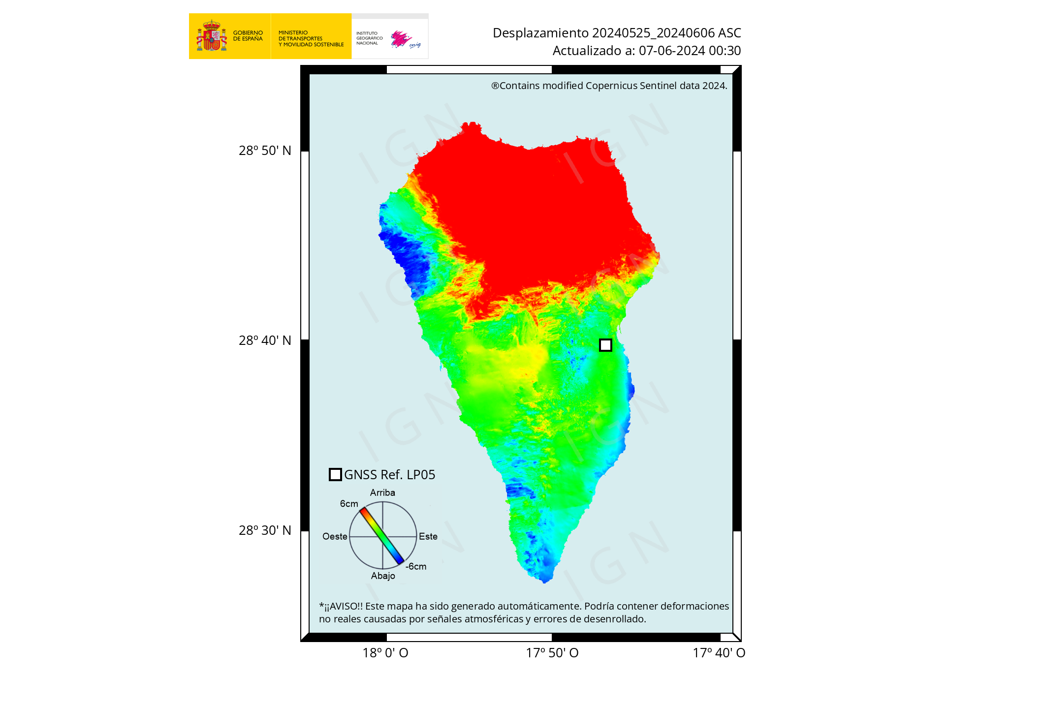 but very light on the map.
Another quote from David Calvo (Google translated)
https://twitter.com/telediario_tve/status/1442478000243494916
And its game on again but with the ‘little’ vent this time.
It started again it seems red pyroclasts flying around
For a whole 5 minutes!
Sorry Charly, I was refering to the little vent not to your post.
And we’ve got lava again!
Yes Squonk it is going all guns blazing again. Little vent was obviously overawed by Big Brother.
It spewing something down that channel again the little one
It does stuff every time my back is turned. 🙂
And we have a long steaming crack on the volcano too emitting copious quantities of white smoke. I am expecting a section of the volcano to slide away. Volcano is being grumpy.
And back at Iceland Fagradalsfjall the tremor is still struggling to rise after 9 days.
Is the main cone spewing out more fluid stuff now?
seemed for a bit some overflow but i must have been wromng
Latest screenshot
lava is moving fast too, I see
At almost exactly 19:16 pm the side vent reactivated and orange hot lava started to stream forth. A big cloud of orange brown smoke announced the vent activation, then the smoke turned bluish gray white.
I rewatched carefully, the vent actually went active around 19:15 time frame, small white smoke and a tiny hot spot. At 19:15:58 a big smoke cloud of brown orange smoke occurred, just above the vent, finally settling down. (perhaps due to a large lava bomb?) Right now at 19:30 pm the vent is fountaining quite vigorously and a growing lava streaming is flowing down.
https://m.youtube.com/watch?v=iOBlB0bFroE
YaY its back.. and same Etna looking lava
The lava is very similar To Etnas own hawaiian style, Only that its more viscous than Hawaii
But perhaps more fresh stuff are comming up?
Reuters showing new lava flow. Going fast on the steep hills not yet reaching too many buildings.
Thermal image
https://twitter.com/involcan/status/1442548810811588608
http://www.youtube.com/watch?v=Vl9jk1UaGZM
Just wow!
Sorry, didn’t realise link already published. nothing showing when I posted this despite refreshing page.
Incredible now!
Oh god.

It’s spreading very fast!
Wow!! Thats one serious Aa flood
Very similar to Etna ..
I can imagine the radiant heat streaming from that
Has return with all fury…..
Yes, the beast is back to life and the tremors keep rising. The IGN website is very difficult to access at the moment. In any case, a decent funding rate at the moment. But I think the houses in front of the lava flow are further away than it looks.
Big lava fountain!
This lava should be more hot. It’s more fluid and clear yellow… this is fresh lava from the deep quakes of last days…
https://twitter.com/involcan/status/1442566348148776961
incredible video!
Still some viscosity to it
Not smooth even close to the vent
Turns to Aa texture very quickly
1949 was more fluid
But perhaps the fresh stuff is indeed on its way now? as you say
confirmed in tv canaria by involcan in an interview they say that the first magmas were more evolved than the last ones
Fagradalsfjall tremor has just jumped.
This flow is HAULING! I can’t tell from the video feeds – where is it heading in relation to the previous flows?
Almost certainly La Laguna and Tajuya need evacuating PDQ if not done so already. A big threat also to Tazacorte on the coast. All pretty big settlements
I think same direction as during the last flow from this area (first west, then moving south and then west again) and joining the old main flow at its northern edge.
This tweet shows very well the conical crack at the top of the cone which I am expecting to slide sooner or later https://twitter.com/planeta_canario/status/1442433681134690306. While the vents were activating, dense white smoke was issuing from this large crack, indicating instability.
In a news video one could see that the lava already reached the first banana plantations downstream close to the Todoque mountain. The plants are covered by nets or foils and are visible as light areas on the satellite image.
Link to an article showing a picture of the flow at the banana plantations:
https://elapuron.com/noticias/sociedad/156209/los-expertos-ven-normal-comportamiento-del-volcan-continuidades-discontinuidades/
Oh dear! And yet more homes in it’s path. Homes destroyed and livelihoods destroyed too. A wonderful spectacle but I so wish the area was not so heavily inhabited. That was what was so refreshing about Iceland. No-one need be in danger unless they put themselves in that position.
I agree entirely
The light brown L shaped building in the centre of the area about to go under the flow is at 28 37 11 N, 17 54 35 W, ie some of the flow is going to go between the two cones by the coast, Laguna and Todoque. Those poor people.
The lava flow front are soure to get moving soon .. perhaps reaching the ocean soon enough
The bannana fields are doomed
Bushcraft Bear has an interesting video for today Monday https://www.youtube.com/watch?v=HDq4xuUNXYs. I wish there was some way to double check some of his information
Is that the video where at the end he quotes from the Director of Involcan that everything is under control and there is nothing to worry about?
No. But he cites earthquake data (16 quakes) and I don’t see that on the quake map.
they happened right after the eruption stopped, further to the south of the eruption site.
As if more pressure was buildiing up
http://www.ign.es/web/resources/volcanologia/tproximos/canarias.html
It was his video the day before that had the quote everything is normal and under control.
https://www.youtube.com/watch?v=FFCWb8fWRsI&t=216s
He talks about it 5 minutes in.
I just found this, I don’t know where the lava field map came from
21:41:54 pm a huge gush, higher than anything I saw from 20:00:00 pm onwards just flew way up into the air along with significant very hot smoke/gas. https://www.youtube.com/watch?v=p0KRg8CiJag
According to a quote on an English article on El Pais, the lava was about 1.6 km from the ocean at around 10.00am, moving at around 100 m/h. Taking into account, the two hours where it went quiet, it could be something like 700m from the ocean now. That is close to some of the comments on the chats (the more feasible were 600-800m), but I dont know their source (the chats show the worst of human nature it seems).
https://english.elpais.com/spain/2021-09-27/la-palma-volcano-ceases-to-emit-lava-smoke-and-ash-but-risk-of-molten-rock-reaching-sea-remains.html#?rel=mas
Looking at the maps, I would estimate the likely entry point to be just north of Playa del Perdido. Unfortunately, there is a cluster of what appears to be houses directly in the path, along with the plantations.
It is going to be wild watching that lava fall over a 100 meter cliff! I watched the delta entry at Kilauea and that was only 10 m or so. I know this isn’t as fluid, but it’s still going to be something to see.
Playa (Playa del Perdido) means beach. From what I can see there is a very steep slope to the beach not a cliff.
Bear will likely give us a decent update later… I have just seen someone in the chat say that there is just 300 left to go… who knows…
It went from 600-800 to 300m very quickly in the chat, I suspect there is a lot of guessing. After mention of 300m, El Pais were quoted as saying 600m, but I couldn’t find anything (at least not in English). f it really is only 300m, then it would have already crossed the LP-2132.
It’s pretty flat in that area, but there are two areas of depressions looking at the contour lines, one goes only a little north of Playa del Perdido (a very steep slope, as Natthagi said), the other is further north again, reaching the cliff near to Loa Celeminos Viejos.
In other news: more on Wrangellia and the million years of rain, subject of an earlier post on VC
https://phys.org/news/2021-09-dinosaurs-ascent-driven-volcanoes-powering.html
https://m.youtube.com/watch?v=-m3fEOGB5y4&feature=emb_title&fbclid=IwAR27sZ2E5rH6jVNml7fym7OxcA5f-bKfCant17MZB6ECHaGxW61T9ARhC1A
Webcam it should hit the ocean soon
Is that a new vent opening on the right – large puffs of black smoke.
https://youtu.be/Fb5edSRGO3k
And small lava jets. In the dark area to the right and foreground of the main vents
Is the main vent in this picture the northmost vent, the one giving off all the lava? or is this view facing north north east? I am trying to get an orientation here. Thanks
No idea! I’m very confused.
Looks like an older stream, on the other streams there is no tall ashy fountain but the flank vent is really going at it. This one looks like it is a replay of at least a few days ago.
Well that’s annoying! Thanks for letting us know.
there are 2 vents here, one erupting about 4x the rate of the other one which is farther right and seems to emit dense black smoke puffs, and they look like they are one some fissure line?
How big are this lava fountains?
https://www.youtube.com/watch?v=Fb5edSRGO3k shows wild stuff now, flames or vent burst open in middle of view but not at the tops of the cones at 23:23 pm.. lots of flames now
By Canary Tv, The lava has only has to 300 meters by the sea, by the lava south arm on Todoque. Sea exclusion zone has been expanded 1 nautic mille to the north coast.
Very useful. Thanks
Sure that isn’t the northern branch? Running north of Mt. Todoque?
That’s certainly the one that was shown this morning 1.6 km away.
Yes, the picture from the banana plantations (see Oliver’s post above) shows an area that is easily found with satellite images to be northeast of the Mountain.
La Palma. 23:30pm UK time.
I’m confused. I’ve one webcam stream showing this: https://www.youtube.com/watch?v=jfFj1V7l1YQ a kind of bubbly fountain and some runny lava.
And another showing a kind of Armageddon: https://www.youtube.com/watch?v=Fb5edSRGO3k
Which one is accurate?.
One is looking roughly north and the other roughly south Clive. They both appear to be live.
But the difference between the two is chalk and cheese. I was wondering if the ‘Armageddon’ one was an earlier recording being posted as a false live to garner clicks.
Maybe I’m just a suspicious grumpy old man! 🙂
Randall also questioned it above. It briefly showed the moon just now from the Todo (looking NNE) stream, before zooming in to some flames.
That is perplexing. My guess would be that both live feeds are real, though showing different vents. Perhaps one is a view from motherly, the other southerly? They would pretty much have to be if accurate, based on the lava flow (though I’ve seen that phone-based cameras seem to invert images).
Clive, the first webcam has real from today. Second webcam has recorded the first eruption days,
Today Webcams:
Canary Tv Online Webcam
https://youtu.be/jfFj1V7l1YQ
La Palma Tv Online Webcam.
Thanks. The ‘Armageddon’ stream from Ahora Directo feed gives no indication it is a recording and says it started streaming 3 hours ago. It is trying to give every impression it is a live stream.
I think they’re telling porkies. It’s click-bait.
I watch out for the “live” clickpoint at the bottom. If its not there and scrolling to the end terminates, its a recording and should be dumped. Below is live as I type.
By gubernamental info, the last info has none confirmed. Actually, has 300 meters to Tazacorte municipality, and 1600 meters more to reach to the sea.
This is also what I read. And it would make sense.
(I found the other information, that the lava is 300m from the coast, about 100 billion times without any source given in Twitter.)
You said it was reported by Canaries TV?
Angel Francisco
27/09/2021 at 22:25
By Canary Tv, The lava has only has to 300 meters by the sea, by the lava south arm on Todoque. Sea exclusion zone has been expanded 1 nautic mille to the north coast.
Is this old stuff? https://drive.google.com/drive/folders/19YyEOiNtmyIJ8XJO0Pd5sjzjmz3melWK?usp=sharing but I took it from the https://www.youtube.com/watch?v=Fb5edSRGO3k youtube channel. It is the one that a snapshot of the moon in it and appears to be south of the volcano looking NNE.
The snapshots shows interesting things, btw.
I wasn’t 100%, but it appeared to be a full moon, which was probably a couple of days ago.
I reckon it’s a fake ‘live stream’.
El alcalde de Tazacorte #LaPalma, Juan Miguel Rodríguez, lo ha confirmado en directo en
@unahoramenostv
: la lava se encuentra a 300 metros del límite del municipio de Tazacorte y a 1.600 metros del mar
#RTVCconLaPalma
https://twitter.com/RTVCes/status/1442620686103678980
(but this could be wrong too, Luis, since it comes from the information limbo Twitter)
This (just now on the ‘real’ cam) looks quite like burning fuel! It looks quite weird for a volcano.

There appeared to a similar appearance the other day too (but much smaller), back when the explosions were occuring. It’s become much more obvious in the last hour or so.
This view has zoomed in on the phenomenon.
https://youtu.be/p0KRg8CiJag