Now that Fagradallsfjall has finally erupted it is clear that a new eruptive period has initiated in the Reykjanes Peninsula, we can expect many more eruptions to come in the following few centuries, but what should we expect? and what about the eruption that has already started?
The last time the Reykjanes Peninsula was active was during a series of eruptions, roughly in the 950-1240 year period. Although there were people around, there was of course no one to take scientific notes, so the information is very sketchy. In an attempt to fill the lost history I have looked at a couple of lava flows in Google Earth and tried to interpretate their origin. And how do I do that?
Volcanic landforms reflect the kind of eruptions that created them, for example the height of a lava fountain is about the same as the diameter of the top of the cone that it creates. There are also various types of lava flows, pahoehoe sheets, aa sheets, tube-fed pahoehoe, toothpaste lavas, raised lava channels and ponds, all of this together, and with the relationship between the various features, the volume and complexity of the lava flow, it can give clues as to how the eruption happened.
Before getting into the individual eruptions I should mention the two general progressions that fissure eruptions generally follow.
Two types of fissure eruptions
We are used to used to seeing Piton de la Fournaise, Kilauea, Galapagos, or Bardarbunga erupt, their fissure eruptions follow one general pattern. First, the curtain of fire, when a long fissure bursts into a chain of lava fountains and for a short time the highest eruption rates are reached. Then the eruption focuses into one or a few vents and stays there, the effusion rate falls exponentially until it stops, or it enters a prolonged phase of slow activity at just a few cubic meters per second. From a curtain of fire to a single vent is the typical sequence of a fissure eruption.
However there is another important end member, this is a somewhat rare type and not many examples come into my mind, but there is a big one, the Timanfaya eruption of 1730-36 on Lanzarote, in the Canary Islands. This is a very dramatic case, but that’s why it’s a good end-member example.
Timanfaya started from one single vent initially, but then over the following 6 years, the focus of activity kept shifting from one vent to another, countless times. By the time it was over there were many vents lined up in a row, so that it looked like a fissure, but no one would have thought that when it started. There was no clear reduction in activity either, it just kept going, a terrible deluge of ashes and lava with no end in sight.
It’s not easy to tell apart the two types from looking at moss covered lava flows from ages ago, however, I do get the impression eruptions of Brennisteinsfjöll and Hengill may follow the Timanfaya type, whilst eruptions of Svartsengi follow the curtain of fire type, I’m not sure about the others.
And now, with that explained, we should start where the Reykjanes Fires started, with Brennisteinsfjöll.
Brennisteinsfjöll eruptions. ~950 AD.
There are four different historic lava flows in the Brennisteinsfjöll fissure swarm. All of them formed in slow eruptions, from fissures that were less than 500 meters long with one to a few active vents, and fountains that only reached up to 100 meters high at most. From what I’ve seen each of the flows must have been erupted in a period longer than a month.
Hellnahraun is an example of a very slow eruption. Lava moved inside lava tubes, it inflated from within and formed many small breakouts of glassy pahoehoe lavas. It was the sort of activity that was typical in the Pu’u’o’o eruption of Kilauea. Lava reached what is now the small coastal town of Hafnarfjörður, on the outer edge of Greater Reykjavik. Taking into account the volume of around 46 million cubic meters, and effusion rates that must have been in the range of lava tube eruptions, 1-10 m3/s, I estimate the eruption most likely lasted around a few months.

Example of pahoehoe lava breakouts. From Wikimedia.
Another nearby flow, Húsfellsbruni, was possibly the longest and most voluminous eruption of the Reykjanes Fires. It forms an extensive apron of lava flows that is extremely complex. It was hard to understand its origin story because at places there are as many as 4 or 5 flow sheets that seem to lie on top of each other. The eruption involved mostly channelized flows and aa sheet flows, but there were also lava tubes, ponds, inflation plateaus, and toothpaste lavas.
Toothpaste lavas, also called rubbly or spiny pahoehoe, are a higher viscosity form of pahoehoe. Although Reykjanes lava flows have a very low viscosity the cooling lavas within the core of aa flows can erupt again from breakouts and form fields of toothpaste lavas, these look a bit like a mix of pahoehoe and aa.

Lobe of toothpaste lavas formed in the Húsfellsbruni eruption, it is shaped like the roots of a plant.
The volume of the Húsfellsbruni lava flow is hard to estimate because of how complex it is, however I wouldn’t be surprised if it came close to or exceeded 1 cubic kilometre. This eruption I’d say most likely lasted one to a few years. There is also the question of whether the historic lava flows of Brennisteinsfjöll represent separate eruptions, or rather just stages in a long eruption with a shifting focus of activity.

Example of a lava tube skylight. Every Brennisteinsfjöll eruption had some of them. From USGS.
Svínahraunsbruni. ~1000 AD.
This eruption happened between Brennisteinsfjöll and Hengill in an unnamed fissure swarm. There are three lava flows that are considered historic, according to the geologic map I’m following. They lie close to each other with vents that line up.
Each of the flows issues from a fissure that is only 250-500 meters long. One fissure is unnamed and seems to have had only weak spattering and a very small flow. Two bigger flows issue from fissure vents called Nyrðri and Syðri respectively, and both had lava fountains that probably reached 50-80 meters high at some point, issuing mainly from 1 or 2 vents. Syðri erupted on top of Nyrðri.

Nyrðri craters feeding a lava channel. This eruption happened around 1000 AD. From Google Earth.
It is hard to know if they formed in one or multiple eruptions. If we follow the Timanfaya model it could have been an eruption with three stages in which the vent focus shifted, but it can’t be ruled out that they were different eruptions altogether.
I shall describe Nyrðri, the biggest flow. Most of the time the lava erupted from a single circular spatter cone, bubbling up or making low fountains that spilled into a lava channel 30 meters wide. Lava streamed down this channel, raised above the ground with flanks covered in shiny pahoehoe. The channel shifted its path a few times throughout the eruption. The lava was channelized for 2.5 kilometres, then it was distributed over a branching system of blocky aa lobes and toothpaste lava outbreaks.

Example of a raised lava channel with pahoehoe overflows. From Wikimedia.
Considering the three lava flows as stages of one eruption then the volume is 110 million m3. I thought eruption rates of 10-20 m3/sec were reasonable for its level of activity, that gives a duration of 65-130 days. This is a guess. The flows may have formed in separate eruptions, but still most likely the duration would be in the range of one to a few months.

Aa lava flow with a folded surface and toothpaste lavas around the edges. Syðri eruption. From Google Earth.
Eruptions of Trölladyngja and Krýsuvík. 1151-1188
Fire is reported near Trölladyngja mountain in 1151 and again in 1188. These reports probably refer to three historic age lava flows that exist in this area. Of these, Ögmundarhraun and Kapelluhraun were large eruptions. Each formed large lava channels running into the ocean in opposite sides of the Peninisula. The other smaller flow was short lived and may have been part of the Ögmundarhraun eruption; their fissure systems line up too.
These lava flows, as well as many other prehistoric eruptions of both Trölladyngja and Krýsuvík, are stronger than those of Brennisteinsfjöll and Hengill: they erupt curtains of fire with tens of lava fountains bursting at once over a length sometimes exceeding 1 kilometre, and very rarely some fountains can reach up to 200 meters height.

1984 Krafla eruption, the Kapelluhraun lava flow from Krisuvik volcano may have looked similar.
In the eruption of Ögmundarhraun intermittent fissures opened over a length of 9 kilometres, I don’t know if there was an initial phase of fire curtains affecting the entire length or if the various segments were activated at different times. The vents opened along the valley of Mohalsadalur, flooding the entire floor. Lava poured in rapids where the valley was narrow, and then dived below the smooth brilliant crust of lava lakes that collected where the valley was flat and wide. Lava entered the ocean in massive flows of aa lavas. It seems the system of winding channels extending towards the coast reorganized multiple times, so it was probably a lasting feature and a significant volume of lava must have ended up underwater.
In the late stages of the eruption activity had focused in a 500 meter long fissure, on the order of 10 fountains were playing to low heights, or some perhaps up to 50 meters, their streams merged into a singular mighty river slowly flowing towards the ocean 6 kilometres away. The flow broke into two branches, each half a kilometre wide, and entered the ocean 2 km from each other, amidst what must have been boiling seawater, dead fish, and towering columns of snow-white steam.

Example of an ocean entry like those of Kapelluhraun and Ögmundarhraun. From USGS.
It seems difficult to make any guesses about the volume or duration of Ögmundarhraun, other than it must have lasted more than a few days, but could have been much more, and that the volume must be more than 100 million cubic metres.
Eruptions of Svartsengi and Reykjanes. 1210-1240 AD.
We arrive to the last volcanoes of the Reykjanes Peninsula as we travel westward together with the migrating activity of the Reykjanes Fires. These two fissure swarms produce intense eruptions with curtains of fire similar to those of Trölladyngja and Krýsuvík, or even more intense. For example, one prehistoric eruption included a kilometre long unbroken curtain of fountains shooting to heights of 100-200 meters.

Example of a fire curtain, a line of fountains, which are probably frequent in Svartsengi eruptions, the lava flow is a sheet of pahoehoe which typically forms in eruptions of >100 m3/s. From USGS.
Svartsengi produced three lava flows, Arnarseturshraun, Illahraun and Eldvarpahraun, I will focus on the first two, which I think are parts of the same eruption.
Illahraun erupted from a 200 meters long fissure, but the eruption was very intense. An area of 8 km2 was rapidly flooded by a sheet of molten pahoehoe lavas, including the present location of the Blue Lagoon. The surface flowed as a mass of crustal plates carried by the molten rock below, as it moved the slabs clashed against each other lifting into broken ridges.
The cones that fed the eruption barely have any prominence and the flow is one simple sheet, this is all probably because the outbreak was very short lived. The total volume was 38 million cubic metres and eruption rates must have been on the order of hundreds of cubic meters per second, so that the effusion can’t have lasted much more than a few days. Illahraun however may have taken place concurrently with the opening of fissures along the same line to the northeast which fed the longer lived Arnarseturshraun flow.
Arnarseturshraun must have opened with a line of fountains and a rapid outpouring of pahoehoe lavas, although this initial stage is largely buried under later activity. The eruption rate declined progressively. For some time a raised lava channel kept supplying lava towards the north which fed a massive slowly advancing wall of aa lava, crustal plates from the initial lava flood as large as hundreds of meters across were rafted downstream and collided with each other raising up meters high ridges of rubbly scoria, much like tectonic plates that collide to form mountain ranges. Activity kept decreasing and some more lava channels were formed to the north, however activity focused more and more around the vents.

Large crustal plates in the Arnarseturshraun lava flow, they are separated by ridges of broken up lava. From Google Earth.
Because the ground is mostly flat, lava had ponded around the fountains of the Arnarseturshraun lavas, this evolved into three lava lakes raised slightly above the ground by overflows, the largest with a triangular shape and 200 meters wide. Small fountains and dome fountains probably played in the lakes and distributed lava over an intricate system of channel and lava tubes leading up to small lava flows nearby. It is clear that this must have been long lasting, more than a few weeks, but it is hard to know how long.

Example of a raised lava lake, similar to the lakes of Arnarsetur. From USGS.
Lastly the historical records mention some submarine eruptions offshore Reykjanes, or by the coastline. An eruption in 1211 formed new islands, called Eldeyjar, meaning islands of fire. An eruption in the winter of 1226-27 is said to have produced darkness at midday, it must have been an explosive phreatomagmatic eruption with ashfall. New eruptions happened in 1231, 1238 and 1240. This last event was the final of the Reykjanes Fires and then the whole region entered a prolonged dormancy that was only broken now that Fagradallsfjall has erupted.
The future
The story of older eruptions can help understand what is to come. I can now make some general predictions. For example, if Reykjanes of any offshore volcano erupts it might be explosive phreatomagmatic and ashy, if Svartsengi erupts it will start with a very intense eruption with curtains of fire and be followed by an exponential drop in effusion rates, but if Brennisteinsfjöll or Hengill erupt then expect slow eruptions at near constant rates.
Problem is that the current eruption doesn’t belong to any of these volcanoes, in fact it opened in a very strange location and it turns out the magma is coming straight from the mantle. According to scientists this is quite extraordinary, and extraordinary magmas bring fantasies of extraordinary eruptions.
There is one very rare type of Icelandic eruption known as a lava shield, or a dyngja. These eruptions are thought to feed from primitive magma from great depths, and they are not associated with the shallow magma chambers of central volcanoes that feed the large fissure eruptions. Many commenters have already been discussing that we may be witnessing the birth of a shield volcano, Irpsit I think was the first to mention the possibility. The reason to think this is that the magma is from the mantle and the vent has opened outside the fissure swarms. A shield is a huge eruption that produces multiple cubic kilometres and lasts decades, it is a slow tourist-friendly eruption with lava tubes and inflated pahoehoe flows. The magma coming from the mantle is certainly a good sign, the last time an eruption came from the mantle was in Mayotte… 5 km3 or more, and still going. But while it’s true that shields erupt magma that is very primitive, it is not true that every eruption that brings out primitive stuff is going to be a shield.

Sandfellshæð, a lava shield of the Reykjanes Peninsula, formed 14,000 years ago, it seems to have had a lava lake or shallow sill intrusions, or more likely both, at its summit. It is cut by normal faults from many grabens that form when dykes intrude. From Google Earth.
So far the Fagradallsfjall eruption has followed a similar pattern to those of Brennisteinsfjöll and Hengill, a short fissure eruption at a slow steady rate. If it is similar in the other respects, the eruption should probably last on the order of some months, but it could also last years if it is a large eruption like Húsfellsbruni, or even decades if it becomes a dyngja. If it is Timanfaya-like then dyke activity may keep going and new vents could open elsewhere as much as months or years from now.
We shall see what comes to be of Fagradallsfjall, but in the meantime we can understand the eruption from a much more full perspective knowing about previous fissure eruptions of the Reykjanes Peninsula in their rich variety.
Hector


.jpg)
Fantastic Article thank you!
Fantastic post! If history repeats itself, then Iceland has an interesting few centuries to look forward to.
Very interesting article! I tried to look them all up on maps but not all can be found.
Meanwhile a lot of ppl are on the hills again.
[img] [/img]
“A counter was installed on the hiking path two days ago. ”
While the lava flow has not yet reached the outlet of Geldingdalur, the LED flow has already reached the road to the south.
https://pbs.twimg.com/media/ExWON__WEAk_ayF?format=jpg&name=900×900
Thanks! I used this geologic map to find the lava flows and their ages:
http://jardfraedikort.is/
What an amazing map. There are so many pretty techy toys to play with nowadays. I may be gone for some time…
But still no sort of Foodtruck around? Are there no traditional meals in Iceland cooked with earth heat (without changing it to power and back to heat or do you have steam pipelines from thermal source direct to the food steamer in the kitchen)?
Volcano bread? Lava pizza? Burning fish?
The MAR neighbors in the south on the Azores know how to cook with free energy:
There is actually. Dark rye bread would often be baked in a hole in the ground. We call them “hverabrauð”. My family made some when I was as a child, baked in the hot spring area of Hveravellir.
Now I’m nostalgic for the old Hveragerði bakari!
Is it possible to pay it some were public or do you have to know someone like your family members?
Sounds interesting for a try…
The latest timelapse, it’s long, more than day, but it’s amazing to see the river growing.
The automatic camera movements I cut out (3 minutes each hour), some of those I collected by view at the end. Mostly the rest is uninterrupted.1 s =1 min
https://youtu.be/VkpNRoVbDFM
And here in one minute
https://youtu.be/1LtcOxwqZoc
The lavaflow has become really pointy on the southern end

Yes the direction of the flow has changed and now follows a patch to that side
Also, thanks for a fascinating article about the region!
Meanwhile I have the Youtube livestream of this eruption on my TV.
https://i.imgur.com/oXghRh9.jpeg
Thank you Hector, nice post!
First time in days I managed to get the ” back” on screen again.
But camera has been moved has it?
Indeed it has. It’s now more like a side view instead of a back view and it’s a lot closer! But look at how close the people are, what if the cone suddenly decides to go all mayhem those people can’t run away that fast.
It has been moved indeed. Somewhere earlier this evening someone decided the left part was not that interesting anymore…
Aaaaarrrgggghhhhhh. That’s no good, we cannot see the valley end on that side now, to see which way the flow exits. Boo, hiss! *throws toys out of pram*
Nice post! We need to find a way of extending our life spans so we can be around long enough to watch this whole cycle.
You all amaze me with the continuing updates on this eruption. Great work!! I think I can speak for all of us in that we certainly appreciate it!
Time travel.
I went back to 2019 and spoke to myself and told the past me about the bad news of the upcoming pandemic and the good news of a new Reykjanes volcanic cycle. My old me was stunned and couldn’t believe it.
I received the visit from my future self in 2121 and told me not to worry about the pandemic, that it would finish in 2023 and other big events would happen and that’s just the way history carried on. He also told me to look forward for the future shield of Gelingdyngja, the fissure eruption of Svartsengi that follows and both will be erupting at same time in 2028, a later lava flood from Hengill (decades later) and a final ash eruption at the tip of the peninsula which makes the peninsula longer.
He also told me that Langjokull erupts mid century (in another shield eruption) and Oraefajokull also erupts, in what will be again the most explosive eruption of the century. My future self works at a space launching pad in Iceland (trips to other star systems and I was intrigued about that). Icelandic climate is balmy by then (and yet climate change has been fixed)
Finally he told me that most of the readers of this blog will have the change to come to Iceland later this decade and see the shield forming.
Disclaimer: this is purely fictional and entertainment.
Isnt all fictional, if this is going to last for years im sure everyone here with the means of travel will go to see it, Pu’u O’o has a successor 🙂
I like the “climate change has been fixed” part 😉
Do you think the Icelanders will watch and wait for the next 300 years and still import fossil fuels before they realize that they could use the magma for…
Even better, import solar panels 🤣
Iceland already is at 100% renewable, when it comes to electricity, 75% Hydro and 25% geothermal, has been like that for decades.
And still no terrorists attacks? I guess because the Iceland Defense Forces 😉
Why do you not export energy like the OPEC? Already too rich?
There have been talks of exporting energy to Europe, look up “Icelink cable” it’s still on the drawing board though
So watch and wait for 300 years more after today…
You don’t need a cable (efficiency per km), you need tankers, pipelines and a few “barbarians” – all you should have in Iceland, shouldn’t you?
https://www.worldoil.com/news/2020/11/18/saudi-arabia-sets-its-sights-on-hydrogen-export-leadership
Lucky You… “time travel” me got lost with bad directions and showed up in the year 1530 with warnings about the pandemic and everyone said.. “We KNOW!”
Maby just a glitch…
Friday
26.03.2021 20:17:04 64.390 -18.310 5.3 km 4.4 50.5 21.9 km SSW of Hágöngulón
something is stirring there, but there is also weather
not a good place for any volcanic activity to kick off
I did some work up towards the top of Kaldakvísl a long time ago
nice up there
nvm – flagged as low quality, prob retracted or lowered when someone wakes up
I think it’s frost quakes. Temperature in the area has been dropping rapidly and the ground is probably saturated with water this time of year. The seismometers see hundreds of micro “quakes” and that confuses the automatic system. Take a look at the SKR drumplot and you see what I mean.
yeah, I saw the weird high frequency behaviour on SKR and then checked the actual vedur.is
Thanks Héctor! That is a very interesting piece to think about.
Very imteresting analysis Hector 🙂
Seems like eruptions get a bit less voluminous but much more intense as you go out to sea to the south, as you say Brennisteinsfjoll mostly has eruptions that look a lot like what is happening now, small strombolian eruptions with stable lava channels for a few months. Hengil I think works differently though it also has fissure eruptions, but much less often than the other volcanoes. I think it is also the only one that is a central volcano, or it was anyway at some point.
To me it looks like maybe the eruption now is not really the proper start of this sequence, more an entirely random event that found a weak spot here. But it has I think rapidly accelerated the progression in the future, it did rupture the fault through Krysuvik leaving the fault section through Brennisteinsfjoll sitting under very high tension, it is likely the first part to break typically but not this time. It will rupture probably some time in the near future and set off its eruptive cycle. Krysuvik has already been partly ruptured, not enough left for a big quake now but its eruptive cycle has probably already been induced to start.
Perhaps a good way of saying this is that the unexpected dike at Fagradalsfjall has probably set up a situation for the entire northern section to be activated at the same time, this didnt happen before but if this is the first shield in millennia you expect it to be a disruption to the pattern.
Thanks! I did notice that eruptions increase in intensity as you move to the southwest, from Langjökull that mostly consists of gigantic slow shield eruptions, to Svartsengi with its flood-like eruptions, although a few eruptions here and there break this rule.
This got me wondering if the Hallmundarhraun eruption, a 8-9 km3 shield in Langjökull formed around the year 930, is related in any way to the Reykjanes Fires, the distance is very large but the timing similar to the start of eruptions at Brennisteinsfjoll.
There was an eruption in the Snaefellsness rift northwest of Langjokull in the early historic period. This area is often ignored as it is not very active but the fact the rift reaches close to Hallmundahraun is interesting, thoùgh the magma for Hallmundahraun is not from there exactly it could be connected to rifting in that zone, or perhaps just as likely no rifting at all. As I have said I think that the central volcanoes of Langjokull are extinct, possibly so is Hengil too, eruptions at these places come directly out of the deep mantle. Hofsjokull is maybe getting towards this, its central volcano is still active so magma goes there but it will one day also be surrounded by shields when it dies and its deep magma can erupt directly. I guess that means the shields around Langjokull are like rejuvenation volcanism, though it isnt completely analogous to Hawaii.
Hallmundahraun is about twice the volume of Pu’u O’o, it could have lasted for 80 years 🙂
Pondering Google Earth and maps, instead of the birth of a shield volcano, might this current eruption be a resumption of ‘the ancient shield volcano’ of Fagradalsfjall?
Geldingadalsgos in parked pretty much in the centre of an area of hills. There are signs of lava outcrops from ancient flows about the edge of the hills. There is a ridge (sorry – my maps are too poor for names) cutting north-east to south-west, from which there appear to be outpourings creating the shield, and hill (old cone) building.
I’ll park this idea here for the experts to slap me down on! 🙂
Fagradalsfjall is a subglacial volcano, made of hyaloclastite. It also isnt clear whether it is on its own or a part of Krysuvik, most sources seem to favor the latter. I dont know if that actually matters now though regarding this magma coming from the mantle, it seems eruptions at Krysuvik otherwise are not shields they are intense fissure eruptions of moderate-large scale, so we still have that to look forward to 🙂
It is truly an incredible thing we are seeing, all the wishful thinking of shields in Iceland forming really anywhere even up in the frozen icy hellscape near Bardarbunga and people would make it accessible, and not only does it actually happen but right in the perfect location, it is literally closer to the airport than Reykjavik…
Interesting! Thank you!
It also looks like Kilauea in 2018 would count as a Timanfaya-type fissure. I dont remember seeing it ever do a curtain of fire, it was always singular obvious vents along a line, fissure 8 was maybe just coincidentally the one that opened at the same time as the caldera collapse turned to piston collapses like at Holuhraun, as opposed to just the overlook vent caving in. Maybe fissure 22 or 13 or 7 would have become Ahu’aila’au if collapse was faster.
Quite a lot of tourists this evening, will be interesting to see what the counter on the hiking trail shows tomorrow
I just wanted to write that Reykjavik has a communal evening out, apparently. Wonder when the bbq’s are brought along. On a second thought… Why would you need a cue if you have a XXXL size lavastone in front of you (wonder what Fluor ans Sulfur do to a steak…)
At least for the sulfur gases every good cook and/or butcher should know the effects on the taste but there are more important things than taste (extinction because nothing too eat in the long winter…)
International Numbering System for Food Additives
E220 to E228 SO2 and the derivatives
E513 to E523 SO3 and the derivatives
What is more efficient than shortening the exp. date for selling more food? Forbidding the conservation additives?
Smoking kills!
truly a pet volcano.
And I can just wish the night cam was a bit more in focus.
It looks like it has problems with the auto focus. Too little detail and contrast in the reds and oranges I assume.
(autofocus is hunting)
Hunting of the autofocus system of this webcam will reduce its lifespan, due to increased wear and tear when it is constantly hunting.
just focus during day and don’t touch :] the back camera used to be sharper, but can’t find the link now
Someone is just at the camera now. I wish I could text him to focus the cam!
unrelated note: this is legit winter gear they have.
Many people there. How will they spend the night when they have to walk a few hours to the parking area?
tents?
But are tents allowed in the vicinity of this volcano?
Flame-proof ones, perhaps!
I think i see people camping
[Imgur]( )
)
They even put the cam in a different place but it still runs like garbage. Their severs probably can’t handle all the people watching at the same time but I wish they would already switch to more powerful servers like Ruv already did days ago.
It’s around one hour walk to the road (from there it depends on how closely you were able to park).
Wow!! All kinds of folks out there now! looks like a rock concert encore but instead of lighters its flash lights!
Not sure if waving with smartphone flashlights at a volcano is really dignified. Also, the god of the underworld might feel offended…
There’s even traces of the aurora borealis on the mountain ridge (could obviously be bunged graffics) and a few stars
a lot of people…they espect smth? do they know smth we don’t?? that’s the night of vents reunion?!?
The screen on the main cam is black, the side view cam is still up but the ppl standing block the view of the cones.
They are playing with cables n stuff on the main cam, who knows perhaps a new camera or something, or just trying to fix the black out clitches.
just switched to different view – has the wow now.
Can you put up a link please.
https://www.youtube.com/watch?v=XkkuxbZAq30
the lava pond is quite beautiful.
Notable that there’s some steaming about 10-20m ahead of the RUV camera… (There is too on the mbl.is one, but that might be due to human activity)
Guardian photo of the week:
https://www.theguardian.com/artanddesign/gallery/2021/mar/26/20-photographs-of-the-week?CMP=Share_iOSApp_Other
Wow amazing photo!
I like the fact that in Iceland that allow the locals get up close to the new kid on the block! Here in Australia I’m sure the police would rope off the site and have a 5km exclusion zone.Also Volcanocafe been very helpful with info about 19th of March Volcano.
Héctor, what an informative and intriguing post, an excellent article! I much appreciate articles like this, lots of new information to learn, to grasp and to rethink about. I especially liked the pictured examples.
Do you think the current dyke intrusion will still spawn a new breakout, say nearer to Keilir or perhaps the longer this goes on, the dyke emplacement will become solidified?
Thank you! The dyke will probably solidify soon, however the rising magma from the mantle could, maybe, build up pressure again and form new dykes nearby with new outbreaks.
There is something heart warming about the views with the night time silhouettes of people enjoying the volcano, like a camp fire. Very peaceful.
Yes. It’s mesmerising and fantastic to hear the sounds, too! The volcano itself – great to hear it – and the people talking (and the odd expiring Icelander with a hacking cough).
I was amused by the couple who had a kiss in front of the web cam!
Er…not to mention the drunk…
All they need are marshmallows to toast!
There was recent comment that the activity of the cones increases at night time.
I personally have observed this occurring during the past few days, but here are two tremor charts of seismic stations close to the Geldingadalir eruption site.
FIF tremors:
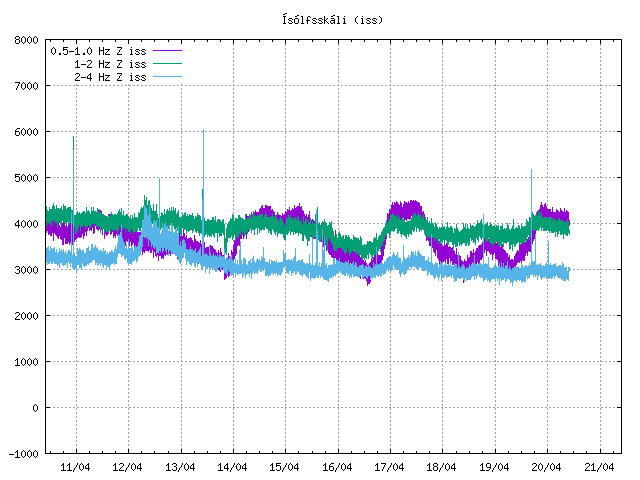
ISS tremors:
You can decide for yourself if the blue tremor (4 hz and above) indicates the true activities of these fissure vents or not.
Time will tell.
The wordpress troll axed my URLs’
“ ” and
” and “
“
“
Please make screenshots next time, because with direct linking them to the IMO servers, they will keep updating and what you want to show will get lost in time.
Right now it looks like one eruptive center and its spewing more than I’ve seen so far. Night makes it look like more but this is different.
Husband off to work and my day begins with coffee # 1 and a quiet contemplation of our Volcano.Has it got a proper name yet? Anyway it’s really going some this morning. Jusutcruz is right it does look like one crater. From a different angle it’s seen to be not quite 1 but very nearly! https://www.youtube.com/watch?v=XkkuxbZAq30. I wonder how many drones have been air fried?
maybe the need to put up a sign “no drones were harmed during this volcano expidition” like in movies when they say no animals were harmed.
yeahhh…youre absolutely but clearly RIGHT!
except the first day movies i didn’t find drone views,..of course the wheather was worst it can be to fly that kind of bug…
i still waiting for a top view…
06:12 and lava is gushing from both vents like I have never seen, clearly increased flow and Icelanders are taking pictures
Here’s some top views for Crise https://www.youtube.com/watch?v=b9Hq6bTBF2A .
thank you! i knew this…i just wonder about a recent one…maybe if we’ll have a top view, now at this moment when both vents are about to be alike as high we can estimate the rim between stability…
Thank you Hector. Even before the eruption, I was studying the different lava flows on Reykjanes. I was wondering if this eruption would end up looking like Keilir until I learned that that one was sub glacial so not the same.. You have answered many of my questions about them and I now feel happy that the reason I couldn’t work out what sort of eruption this was is simply because it IS different and even the experts are not sure. So like us all I can sit and watch this eruption knowing that I am seeing geological history in the making and yet another piece of the jigsaw puzzle of Icelandic Volcanism fall into place. Hector this article is brilliantly written and so easy to understand , even for newbies Newbies. Your time given to write this is really appreciated here.
Quite a few visitors were there last night/evening https://www.maelabordferdathjonustunnar.is/is/gosslod-geldingadalir the line of cars on the road stretched for five km, generally everything has been fine during the day, but some accidents (no details on what exactly) and three people have had to be transported to the hospital.
Also, in two weeks time there will be no actual “Night darkness” but we will then have entered what is called Astronomical twillight, then two weeks later, it is Nautical twillight which will go on for a few weeks, and so on and so forth. What I’m saying, is that the days are getting longer with about 6.30 min each day, and the nights are getting shorter and shorter.
https://www.mbl.is/frettir/innlent/2021/03/27/morg_thusund_manns_i_geldingadolum/
Around 10.000 they say
People are still there on both cameras, it looks as ifbthere were quite a few all-nighters.
The lava is erupting at 1190 C and it never stops.. I think this is going to become a shield, feeding from the mantle.
The magma is still rather olivine crystal rich, so it does have spend some time far undeground.. now pushed out by fresher stuff. Still 1190 C is hotter than most other lavas on land. Sometimes bright yellow orange in daylight the spatters are
Most other lavas this hot erupts at superfast spreading ridges under the sea.
A new webcam closer to the eruption have been added! overlooking the western vent
https://m.youtube.com/watch?v=XkkuxbZAq30
The chat has decided to call the volcano Bob 🙂
It has also just occurred to me that this is our modern day version of Paricutin, truly a volcano appearing where there was none before and which is likely to be of a significant size eventually. Everyone here can now say they have got a mountain younger than them 🙂
I think they must all be called BOB
I think of the volcano as Castor and Pollux – Gemini (the twins)
Me thinks GEORGE would be a better name. And isn’t George gorgeous.
What’s wrong with VolcyMcVolcface?
Where do I start?
Well, not Scottish?
Changed back to the RUV feed as it became too psychedelic, constant rainbow colours.
https://m.youtube.com/watch?v=1LtcOxwqZoc&feature=share&fbclid=IwAR25nHpoIUtoyl9xGe_aUsmioPL2ANZ68Pec1BEilnoBspZrM5ZxrPaaAIU
I name the west vent .. Gollum
The eastern vent Sméagol
The cone complex will be named Baggins cone : )
Gollum vent haves by far the largest output rates
YES!!
It is the same webcame as the first cam from RUV, just hosted by another group and added a live chat feature to it.
I did notice that about half way between the Husfellsbruni volcano and Tvibolar, which is the vent for the Hellnahraun flows, is where the Thrinukargigar volcano is. That is the one which after the eruption drained out its interior so you can climb inside it.
I wasnt sure where it actually was in Iceland, but it looks to be a part of Brennisteinsfjoll. It is actually quite surprising then that the cavern has survived, being that at least one and possibly several large eruptions have happened so close to it and surely a number of large earthquakes.
I been inside Thrinukargigar many times … lava been so fluid there it looks like molten chocolate thats flowed down the walls .. hot insulated chamber
The entire chamber sourely glowed for years after .. a terrfying glowing abyss to fall into after eruption stopped.. even today .. its a scary place you fall down .. If you not careful
Luckly its an elevator there.
Probaly was a lava lake body inside there when it was active
Yes it seems that it was a slow eruption, as Hector says is typical of this area. It is interesting then that the vents are not shields but spatter cones, maybe eruption isnt continuous but episodic so lava is not always flowing out of the crater but it is always fountaining so builds a cone. That would explain the structure of Husfellsbruni, its not steep enough for that to be the explaination for the abundance of a’a, it must have had eruption rates higher than about 5 m3/s but not continuously.
Looking at http://jardfraedikort.is/ though it looks like the existing cone was a very small eruption, a minor vent of a bigger fissure that was further south. It reoccupied an older fissure that was 6000 years old, with the new eruption being a bit over 2000 years old.
That’s interesting! I didn’t know.
I was expecting to see the hill in front of the cones to grow more than it has, seeing how it much grew the previous night. Also they say the magma temp is 1220 – 1240 degrees.
https://www.mbl.is/frettir/innlent/2021/03/27/jafnt_flaedi_heitustu_kviku/
If that temperature is true then this is one of the hottest eruptions ever observed, and all but seals the case for it being a shield in formation. Kilauea Iki was still hotter, but that is probably to be expected beign that it erupted out of the 1500 C depths of Kilauea. In this case though there is nothing above it, truly is a hole in the earths crust if there was ever a better example.
I think it is probably appropriate t ocall this its own volcano now, it is erupting in the fissure swarm of Krysuvik but it is not part of it. That might mean the true eruptive cycle has not actually yet begun, the one that will mimic the Reykjanes Fires. I think that will begin when that expected 6.5 quake at Brennisteinsfjoll finally happens, and probably Krysuvik will erupt at the same time too, the fault has ruptured there already now and decompression melting is likely beginning.
Wow!! Making it one of the hottest lavas ever seen in action by modern cameras! A good hotter than most other basaltic lavas that erupts on land surface
That is really really hot!
But I have some doubts. It doesn’t say how it was measured. The other measurements, of 1170C, came from the crystal-liquid balance and should give an accurate temperature just underground. It is hard to see how it can get hotter while erupting. Also, it seems to say that the temperature was this high during the onset, not that it has grown hotter over time. Wait and see. Until some details are available, I prefer to use the earlier numbers.
Yes, perhaps we should wait before jumping to conclusions.
Today it’s the first week since the eruption started.
offtopic: Etna seems to have calmed down looking at the cam now, I only see some faint smoke.
instead of reunion they start to run apart….i already name them stan and bran, obvious bran is the right one…
ASOIAF reference?
We will see How much crystals are in the magma… samples. At 1240 C most crystals in bowens basalt reaction seriers should be molten glass liquid .. leaving only a few Olivine flakes.. the magma should be almost crystal free at these temperatures.
The first lava samples 3 days ago at 1180 C where crystal rich. Probably from an old magma pocket like what happened with Kilauea during the initial eruption
Doubtful, since this area had been inactive for 10,000 years at the start of this month. More likely, the initial crystal-rich 1180C magma had sat in the dyke for a week or two. Once the eruption started, the slightly stale dyke magma along some corridor from the deep conduit to the eruption vents would have erupted first, followed by fresher material coming straight up the pipe from 20 km down without a week-or-two stopover in the dyke along the way. That’s probably why the eruption seems to be both hotter and a bit faster now.
It already seems to be building a kind of mini-shield in front of the vents’ shared spatter cone.
Meanwhile, the RUV cam seems to have got the jitters. Some of it might be put down to the wind rattling it, but it keeps having episodes where it seems to “pulsate” like the vision of a woman with a migraine. Outlines of objects shift oddly and the overall view seems to zoom in and back out slightly with each pulsation when it’s doing this. Brief blackouts are occurring as well, and some change in the settings made the vog much brighter in the thermal view (obscuring what was happening at the vents in a large blob of glare) and much more opaque in the daytime view (obscuring, much of the time, what is happening at the right-hand vent) compared to yesterday at similar local times-of-day.
Fortunately, it sounds like they will have months to work out the bugs in the camera system and get everything running smoothly and stably …
The first days the front cam was crystal clear and now its like only 240 or 480p and indeed black outs and purple colors. The side cam is much clearer like HD.
https://www.mbl.is/frettir/innlent/2021/03/26/beint_eldgosid_i_fagradalsfjalli/
But… “like a woman with migraine” ?
I believe this may be a youtube compression problem.
Has the lava reached the valley beyond? There is smoke comin up from behind the ridge on the right of the webcam.
I created a probably pretty much redundant timelapse video: https://youtu.be/MoUgXiZ04GE this was rather time-consuming, not sure if I will continue to do this…
It seems to me that the flow rate has decreased a bit overnight. Let’s see when it picks up again
“Instead of closing #geldingadalir area, a huge team has been working on making it ‘safe’ for visitors by making paths, putting up a mobile connection, making site specific weather forecasts and having rescue teams wearing gas sensors onsite, ready to help in case of emergency.” https://twitter.com/krjonsdottir
That being said, the area will be closed by the authorities at 13:00 today due to weather https://www.ruv.is/frett/2021/03/27/loka-klukkan-eitt-og-fylgjast-med-erlendum-ferdamonnum
From yesterday, friday 26/3


“After days of clouds with a chance of snow one of Planet’s high-resolution SkySats captured a glimpse of Iceland’s Fagradalsfjall volcano. Imagery including near-infrared light (second image) highlights the path of the molten lava.” https://twitter.com/planetlabs/status/1375554504247099394
Kipuka ahoy!
Apologies for tardiness, home-made compost doesn’t seive itself.
Do I see a general increase in tremor in the area? Looking at the GRV and KRI highpasses. It might be weather, or even traffic from tourists. I know wind and snow are forecast for later in the area.
A visitor’s view.
https://youtu.be/2Bsv3rW_YOQ