Lately, I’ve been busy with a project that has precluded me from posting in VolcanoCafe. I have wanted to post about the ongoing awakening of Kilauea’s East Rift Zone, but that will have to wait for now. Instead, I thought of posting something about what I’ve been working on lately. For reasons, I’ve found it interesting to document historical large hail events in Spain, and today is the anniversary of one of the largest storms in terms of hail size in Spain if not the world even. This storm, locally known as the “Pedrisco de San Roque”, took place on 16 August 1859, in the province capital of Albacete. I fished it out of oblivion by looking into old, historical digitized newspapers. There is at least some relation to volcanoes, so it’s not entirely off-topic, and there have been floods and earthquakes in VolcanoCafé before, so why not hail?
Indeed, hail is not as dramatic or deadly as hurricanes, or tornadoes, or floods, which are far, far better documented in contemporary literature. But they are a very relevant meteorological phenomenon that has been very prominent in the more rural world of many decades past when a summer hailstorm could ruin the crops of a village and drown it in poverty. Old newspapers dedicated much time to hail despite their much more limited space than current news. Back then, it seemed more present as people were more familiar with hail and its detrimental effects. So here is a story about a particularly remarkable hail event from 165 years ago.
Geologic setting
The area of Albacete is home to an interesting volcano-tectonic history, so while we are at it we might well look into it. SE Spain is actually a subduction zone. Europe has some of these stealthy little-known subduction zones, or pseudo-subduction zones, that are sort of stuck but still have oceanic slabs hanging down into the mantle. One of them is the Caucasus, where stratovolcanoes with typical subduction zone chemistry are found, like Elbrus or Kazbek. A less volcanic one is the Carpathians, with subduction beneath the eastern side of the mountain range, and another “typical” albeit weak stratovolcano which is Ciomadul. Yet another zone is the Gibraltar slab, a sheet of Atlantic crust subducted underneath the Gibraltar Strait and going down several hundred kilometers into the mantle. I don’t fully understand all the complexities in the area, but I expect all of this pull continues to try and move some stuff around, so probably has something to do with the Great Lisbon Earthquake of 1755. The area is not presently volcanic, but until recently (geologic scale recent) there was a volcanic arc in the area, a very small one at that, but a volcanic arc.

Map with places mentioned.
In the Mediterranean Sea closest to the Gibraltar Strait, a series of submarine stratovolcanoes grew. Arc volcanoes also formed on the coasts of Spain and Morocco. In Spain, the main volcano was a volcanic field on the southern coast of the country, the Cabo de Gata volcanic field. Cabo de Gata volcanism was typical subduction zone calc-alkaline chemistry, although a relatively weak volcano. It was active from about 13 Ma to 8 Ma (million years ago). I have never been, but despite heavy erosion, I expect lava domes, pyroclastic deposits, and intrusion exposures must be outstanding in the arid landscape of SE Spain. After the Cabo de Gata volcanism, there was a phase of intraplate volcanic activity that lasted from about 8 Ma to 6 Ma. This phase yielded small monogenetic volcanoes over a wide area of SE Spain, but with the curiosity that they erupted exotic magmas of “lamproite” affinity.
What are lamproites? I don’t know too well, and I’m not sure anyone does. These magmas are weird. Very weird. They are a vast family that belongs to the larger family of ultrapotassic volcanism, very common around the Mediterranean. Ultrapotassic is a variant of the yet larger family of alkaline volcanism, but with the particularity of having a lot of potassium and little sodium, sometimes making very explosive caldera volcanoes, having isotopic compositions that generally point at heavy contamination of ancient continental crust, and happening around subduction and collision zones. The mainland Italy volcanoes are the foremost occurrence of ultrapotassic volcanism in the world (like Vesuvius, Campi Flegrei, or Colli Albani), and there is also the relevant example of the active Gölcuk caldera in Turkey.
Spain’s ultrapotassic volcanism is very minimalistic and just comprises some sparse, isolated, monogenetic volcanoes. The magmas are so odd though, mineralogically and chemically speaking, that various names: fortunites, verites, jumillites, and cancarixites, were coined exclusively to classify the SE Spain lamproitic lavas. Lamproites are unusual in that they can be high in magnesium and high in silica at the same time, so sort of being primitive and evolved simultaneously. They can rise straight from very deep, in fact in cratons lamproites can carry diamonds, as in Australia. Maybe they can even be compared to effusive kimberlites with more viscous lavas. They are rare, none are known to have erupted historically. 8 Ma Piton de Cancarix is the most prominent example in SE Spain, a dome or plug with columnar jointing that crowns the top of a hill.
Other minor volcanism has continued in the SE Spain area very sporadically and will probably continue. Regular intraplate volcanism. For example, a single volcanic cone in Cofrentes that is 1-2 million years old, or the volcanic field of Campo de Calatrava, which continues to degas magmatic CO2 at present.
The San Roque hail of 1859
Amid this geologically alive area lies the city of Albacete, capital to the province of the same name and stage to a massive hailstorm this day, August 16, 165 years ago. It had 16,000 inhabitants at the time. The reason for this area’s storm activity is also rooted in geology, particularly the Africa-Europe collision. Collision has pushed much of Spain into elevated mesas and mountain ranges and closed the Mediterranean, turning the sea into a remarkably hot and salty mass of water. In summer, radiation from the Sun heats the high areas of the Spanish interior where air rises and pulls more air inwards on the surface so that moist unstable air of Mediterranean origin can then blow from the coast towards the highlands. Albacete is found in one of such breeze areas. When cold air in high levels of the atmosphere associated with lows or cut-off lows moves over Spain it can interact with the moist hot air and trigger intense thunderstorms. Air blowing in different directions at different altitudes, the westward Mediterranean breeze on the surface versus the eastward winds spinning around the low, combine to produce rotating thunderstorms known as supercells, which over the rough, complicated topography of Spain have it hard to narrow their updraft (ascending winds) into tornadoes, but are very proficient at producing giant hail. Every year several supercells bring hail exceeding 5 cm in diameter to eastern Spain. These are somewhat similar to volcanic plumes, both thunderstorms and volcanic plumes can keep fragments of solid material suspended in the air because of their intense rising air currents, one drops chunks of ice, the other chunks of rock, but in the end, both are types of falling projectiles that can shatter crystals, damage roofs, or injure people. Of course, the ice melts away, and the rock does not, but both come from strong currents of rising air.
There are two sources with detailed information on the San Roque hail that I’ve found. First, is the newspaper from Albacete city “La Semana”, I haven’t read the original news, but the text is reproduced in many other Spanish news a few days after the storm. Second, is a letter from an Albacete habitant sent to Madrid which via personal contacts made it to the Madrid newspaper·“El Clamor Público”. According to these sources, it’s possible to get a fairly good idea of the events. At about four and a half in the afternoon, an unusual sound could be heard in the city, it was similar to a train, but people did not know where it came from. Unbeknownst to the inhabitants, a powerful thunderstorm was approaching and already carried gigantic hail that, as it impacted the ground, made a deep, sustained noise that carried to a distance ahead of the storm. This noise is called hail roar. Around five in the afternoon, some fragments of hail started to fall over the city, and ten minutes later, a shower of hail and water unleashed in full force. As translated from the El Clamor letter:
“The first hailstone that fell in the house, or rather that we saw, was in the patio: it broke into five pieces each like a lemon: the ones that hit the wooden shed felt like cannon shots. The pieces that broke on the opposite wall and on the paving have destroyed the windows of the balconies (…) Tomorrow or the next day I will have to re-til it, because the roofs look like a pile of ruins.”
When large hailstones fall on hard surfaces, they shatter into smaller pieces, and from the letter the secondary fragments propelled to the sides were large enough to shatter windows. The size of the hail may have been gigantic, as we will see later, and this resulted in heavy damage. La Semana gives some examples of the mayhem that the falling fragments of ice caused in the city. Hailstones caused severe injury to the heads of some people, knocking a man unconscious, and also killed sheep because of serious head damage. The hailstones shattered crystals and roof tiles and also caused some remarkable damage to the roofs of the city:
“In the barracks, a hailstone of such enormous size fell that it shattered a ceiling beam, and the people who were found inside fled in terror to the basements and caves to take refuge. At the Institute, more than thirty holes have been opened in the roof. In many houses, which we do not detail because it would take too much time, the hailstones have made large holes, especially in the roofs and sheds of little resistance.”
The matter of the size
According to La Semana:
“With regard to the size of the hailstones, everything we say is unbelievable because we ourselves would never have believed that stones larger than eggs had fallen, and on Tuesday we saw them nine inches in diameter and weighing three pounds and two and a half ounces. Stones weighing two pounds, and pound and pound and a half in weight have been found in many garbage dumps.”
And according to the letter in El Clamor:
“Some 33-ounce stones and many 20-ounce stones have been weighed after the storm ended. In a house in Plazuela del Hospital they had the serenity to weigh one that got into the doorway in the middle of the storm, weighing 4 pounds minus two ounces.”
What makes the storm so interesting is the mentioned size of the hail which would be among the largest overall reported events worldwide, and above the records considered by “World Weather and Climate Extremes Archive”, which however is either not aware of some bigger reports or has disregarded them because of the measure not being verified by scientists when taken. The units used in Albacete are the same Castilian units that were in use historically over most of Spain. A Castilian pound is 460 g, an ounce 28.75 g, and an inch 2.32 cm. I’m not sure how the distance was taken but weights were widely measured at the time with scales because of the need to measure amounts of food or other materials, but I’m no expert in this and if anyone reading the article knows something about late 19th-century measuring scales I’d be more than interested into any insight. People were curious to know the size of hail, and having no cameras or mobile phones to record images and share them, the information consisted instead of measuring weights, which was a very common practice for hail in Europe and the world until 2000 or so when visual media gradually kicked in and information got better but worse at the same time, and now hail weight measurements by people is a very rare thing to see.
The point is that La Semana describes stones as up to ~21 cm in diameter and 1450 g in weight, few details are given though, like if the measures correspond to the same stone or not, or when or where it was collected, but both values are quite exceptional. The letter in El Clamor gives details for a 1770 g hailstone collected while the storm was happening that entered a doorway. The record hail weight recognized by the “World Weather and Climate Extremes Archive” is 1020 g in Bangladesh in 1986. When I mentioned this news before people, they were interested but I only got to know the opinion of two meteorologists who thought the values were too high to be correct. On the one hand, the values are indeed very high. On the other though, two different sources roughly coincide in the weight, and old sources of information tend to be more reliable than contemporary news sources. I have worked before with Hawaiian newspapers from around the same time, from 1868, for the article regarding the Mauna Loa eruption of 1868, and found them to be reliable, similar to how I feel about weather news in Spanish newspapers when handling them. The damage to roofs with many holes opened through some of them I think is suggestive of many stones weighing around 500 grams, which coincides with the statement of 20-ounce stones (~600 g) being numerous as mentioned El Clamor, below 500 g I think it would be very difficult for them to fully puncture roofs. But of course, this is not a debate that will be settled immediately, and it has merely started.
Regardless of the exact size of the hail, it was quite big and reminds me of how houses near Ruang got holes in their roofs during the volcanic eruption earlier this year. Isn’t it amazing how nature often parallels itself in very different things? Well, I hope I can return to volcanoes soon and drop a much-needed update on Kilauea, I’m also traveling to Etna towards the end of the month and maybe I’ll feel inspired and write an Etna-something.
References
La Paz (Murcia). 20 August 1859. Page 1. https://prensahistorica.mcu.es/es/catalogo_imagenes/grupo.do?path=1000100478&posicion=1&presentacion=pagina
El Clamor público (Madrid). 19 August 1859. Page 3. https://hemerotecadigital.bne.es/hd/es/viewer?id=0afe57a9-8001-4209-8253-f8e0e562348b&page=3


I can’t imagine the horror of being caught in such a hailstorm. In Sweden, we rarely get hailstones larger than maybe a centimeter in diameter, but exceptions do happen. I experienced a very intense thunderstorm (by Swedish measures) earlier this summer. I started to get a bit nervous when the hailstones grew and grew and started getting over 2 cm in diameter, which is the largest I have ever experienced, but they never grew any larger than that and the thunderstorm disappeared as quickly as it started. It caused some minor damages to a couple of squash plants, but that’s it. 10x larger than that and 1000x more mass is really difficult to get your head around (and nothing you would ever want falling on your head).
Scandinavia is the most dull severe weather conditions in the world, cloudy, humid and cold with very low light conditions for most of the year and certainly the summer seasons dont build up enough atmospheric energy for any really monsterious thunderstorms. You right most of the hail we gets are small ”dog food pellets” from weak thunderstorms with fuzzy anivils
Are you looking foreward towards the comming winter?
Sometimes in summer the best/warmest temperatures are found in the far northeast (Sami territory) close to Russian border. There anticylcones are more stable than in other parts of Scandinavia.
As a weather enthusiast, I really enjoyed your article, Héctor. Thank you!
Thanks!
Thank-you for the interesting geo-meteorological excursus, Hector!
I remember that in a Roland Emmerich (The Day after Tomorrow) movie they showed how big hail stones kill people in Tokyo. The impact of big hail stones are like stone bombs by artillery. If a hail stone has the weight of 1 kg, the speed of the falling hail stone will multiply the force with which it hits the ground. Heavy hail will likely break the resistance of air to fall velocity much better than small “popcorn” hails. Imagine a speed of 50m/s. E = 0,5m*v²; m=1 Kg; v²=50m/s; E = 0,5*1kg*2500m²/s² = 1250 Joule
1250 Joule is the force needed to move one kg over a distance of 125m
Why is there so much strange alkali volcanism in the Mediterranean Sea? Is it related to the long geological history with the split of Pangea? There was a supercontinent that was rifted like the East African Rift valley. Maybe the chemistry of the rifting history still survives, even if the continents are subducting again. How far did the Iberian Peninsula and Africa divorce before Africa decided to come back to Europe?
Yes, hail can be deadly. In Spain, there is a well-recorded case of hail up to 0.5 kg in weight leading to the death of three people in the village of Zuera. The hail fell with a downburst, which I think must have accelerated the hailstones to the necessary speed to be deadly. In the Albacete case, instead, there were no reported casualties, but no strong wind is described either. So I think maybe the hail had a slow descent as it fought with rising air currents in the updraft, but it’s hard to know how it works exactly.
In general Africa and its surroundings have most of the present-day alkali volcanism. The top nephelinite volcanoes are Nyiragongo and Ol Doinyo Lengai (both African), top basanite volcano is Nyamuragira, followed maybe by others like Mount Cameroon, La Palma (Canary) or Fogo (Cape Verde). Strong alkali basalt-trachybasalt volcanoes are more common in the world, but still the most productive is our beloved Etna and Azores is a very productive such province. Then there’s Italy and its unique ultrapotassic volcanism, like Vesuvius or Campi Flegrei. So a lot of the world’s most alkaline volcanism seems concentrated in a relatively small area.
The Sahara volcanoes support the rule of alkali volcanism of Africa. I’ve looked for Atakor Volcanic Field (Hoggar Province) in Algeria. There the major magmas are:
Trachybasalt / Tephrite Basanite
Trachyte / Trachydacite
Phonolite
https://volcano.si.edu/volcano.cfm?vn=225005
Phonolite is the explosive alkali magma that caused the apocalyptic eruption of Pompeii. It is as dangerous as Dacite.
There was a 3.5 at Barfabunga earlier today.
Specialist remark:
“Today at 16:55 an earthquake of size 3.0 was measured in Mýrdalsjökull. One aftershock was recorded, and no tremor follows. Earthquakes of this scale are rather common in Mýrdalsjökull.
Today, at 02:53 a M3.5 was detected in Bárðarbunga, several smaller earthquakes followed. Earthquakes of this magnitude are common in the area.”
Maybe some hydrothermal subglacial activity, as several earthquakes at 0.1 km depth indicate. But a moment to remember that Bárðarbunga usually doese ash eruptions like Grimsvötn. Not as frequently as Grimsvötn, but maybe 1-2 in a century. 1910 was the last significant tephra eruption of Bárðarbunga (Loki-Fögrufjöll).
The “Specialist remark” was from IMO, not me 😉 https://en.vedur.is/
I think Bardubunga more commonly does fissure eruptions, e.g. Holuhraun and Veidivotn. There have also been suggestions that other fissure eruptions usually attributed to Grimsvotn or Katla may have been Bardabunga, but not proven or widely accepted.
Around 1986-2011 there were probably several subglacial eruptions of Loki-Fögrufjöll.
https://en.wikipedia.org/wiki/Loki-F%C3%B6grufj%C3%B6ll
RÚV has a story today about it.
Earthquake of magnitude 3.5 hits Bárðarbunga (16 Aug)
I checked the IMO data, it was pretty deep: 4.9 km.
Pu’u O’o GPS now showing obvious movement, 2 cm of extension across the ERZ in about 2 weeks. From 2021 to recent was 12 cm of contraction, so at current rates recovering this will take about 12 weeks, 3 months, November or so.
HVO: “magma is accumulating beneath the ground in the area of Makaopuhi Crater and Nāpau Crater … earthquake swarms may occur with little or no warning and result in either intrusion of additional magma or eruption of lava in these regions.”
Anything or nothing can happen anytime …
I think it will be hard to erupt until the middle ERZ is filled back to at least the point of 2021, but then that also assumes all of the supply is going there which the tilting at SDH and Halemaumau suggests is not the case.
Actually, its pretty notable that NOWHERE is deflating, at all. Only the stations further down the ERZ show what looks like deflation but it is just a lack of magma here, and that will probably change soon. Everywhere else is getting input, which implies the magma supply is high enough to do it. The level of inflation under Halemaumau and the south caldera is actually about the same as before, maybe slightly reduced but it is coming down off of an all time record so present rates are still very high. The ERZ is uplifting at rates around 10x faster than the same areas were subsiding over the last 3 years.
I already had a rough calculation for UWE tiltmeter that 1 microrad there is about 1 million m3 of magma into Halemaumau, maybe a little less. So in the 3 weeks since the ERZ became active just Halemaumau has been fed at a supply of 0.6 million m3 a day on average, which is a rate of 0.22 km3 a year. Even if you half this number for uncertainty it is still getting over 0.1 km3 a year and magma is still inflating other parts of the volcano very fast. SDH is tilting less than before but not dormant, the SWRZ isnt actually out of the running yet. And the ERZ is clearly getting a huge supply if it has filled so much in only 3 weeks, its just very hard to tell actually by how much… Still, I would put the current supply rate at probably well over 0.2 km3 a year, and at the high end of 0.4 km3 a year presently. The Pahala quakes have been very active recently too, I am increasingly believing that the point those quakes got obvious around 2018, and especially the post 2018 major swarms, were when magma down there began to get into Kilauea, and this last year is when the effects started really showing. The uplift is on the scale of almost a full meter in a year in the south caldera, and a rate of about half a meter a year on the ERZ, if it is to continue that long anyway. I think we are probably within a year of full recovery from 2018, and with that a return to the hyperactive volcanism Kilauea is now infamous for.
I am very interested to see Hectors take on all of this.
One interesting part in Pu’u O’o eruption was that consisted of two shield eruptions: Pu’u O’o (1983-1986, 1991-2018) and Kupaianaha (1986-1992). I remember TV documentations of the early 1990s which assumed that the eruption had left Pu’u O’o for the Kupaianaha crater. How certain was the return to Pu’u O’o 1991-1992? The Kupaianaha eruption looked very stable with a broad area and high volume.
The university of Hawaii has published this (outdated) overview over the Kupaianaha eruption: https://hilo.hawaii.edu/~kenhon/GEOL205/puuoo/puuoo2.htm
Scientists on the ground were 1986 caught by surprise by the new dike for Kupaianaha and had to escape.
Map of 1983-1994:
Kupaianaha was just the first of many flank vents of Pu’u O’o. It wasnt really a completely separate thing, its name is also a bit ironic, as it means ‘sttange (or something on that line) but actually the same exact thing happened again 3 more times and even in the same place in 2007, which buried most of the original. Lava from Pu’u O’o directly also buried both of these shields northern flanks almost entirely in the mid 2010s, they are not even really topographically distinct, but common topo maps are from 2005 so show none of this.
After 1983 all of the Pu’u O’o eruption was either at Pu’u O’o itsepf or from vents nearby that branched off from it, not deeper in the ERZ. Only exceptions to this were the dikes in 1977 and 2011, which were mostly independant just nearby. And 2018 which ended it all. Kupaianaha and TEB 2007 shield were fed by shallow dikes within 1 km underground, satellites of Pu’u O’o.
I wonder too if having a possible shield even lower down than Pu’u O’o, might give us an eruption that is 40 years long, 50 even. 🙂
I dont know if this is really useful, but 10 km east of Pu’u O’o the elevation is about 480 meters elevation. Pu’u O’o erupted from a spot that was at about 730 meters elevation. Mauna Ulu around 950. So Pu’u O’o was at about 77% of the elevation of Mauna Ulu, and lasted for about 6x as long. 480 meters is at only about 51% of Mauna Ulu pre-eruption spot, or twice as far down as Pu’u O’o relatively. So if this is the only variable we could get an eruption 12x as long as Mauna Ulu, or 60 years 🙂 In real life though having magma flow through 30 km of the ERZ would make it erupt a little colder, but the high supply and continuous flow would also counter this. I think it is at least possible we get an eruption of decades long again, though maybe not 60+ years.
Hailstones this size are very rare but do exist. They can’t form by themselves at this size but they can grow by sticking to other hailstones while falling.
https://www.severe-weather.eu/learnweather/severe-weather-theory/hail-world-records-the-biggest-heaviest-and-deadliest-hail/
As a meteorologist who studies cloud physics, including hail formation (though I hasten to add it is not my main focus), I’m very skeptical of the claim in this article. While I don’t want to say that it is impossible, there’s very little evidence for the existence of hail “agglomerates”, and the article does not cite any sources for this. It would be very difficult for falling hailstones to stick together owing to the large range of fall speeds that hail of different sizes exhibits; it would be much more likely that they would simply bounce off of each other. Also, the “recycling” model the article puts forth is rather outdated. Our best current understanding for why hail obtains the layered nature it has does not require any repeated excursions through updrafts and downdrafts, but rather can be explained by the growing hailstone moving through regions of an updraft with varying supercooled liquid water content, that can cause the hailstone to switch back and forth between wet and dry growth regimes as it travels through the updraft. (Wet growth occurs when the hailstone collects so much supercooled water at a time that it cannot freeze all at once, and some of it collects as a thin liquid shell on the surface, which freezes slowly into a clear ice layer. Dry growth occurs when the liquid water drops freeze almost instantaneously, and leads to a milky or cloudy appearance to the layer because of the trapped air bubbles between the frozen drops). The bumpy and spiky appearance of large hailstones can be explained as a result of the complex aerodynamics of supercooled water flowing over the surface as it is being accreted and the hailstone tumbles chaotically.
As for how hail can get to very large sizes, it’s important to recognize that even once the hailstone becomes too large for a given updraft to suspend it, the hailstone can still be growing by collecting supercooled water on its way down, at least until it falls below the melting level. The key for large hail growth seems to be a combination of updraft strength, size, and the trajectory that a hailstone takes through the updraft. The longer the stone can stay in the updraft, the larger it can grow.
This review article contains a lot of good information on the current state of our understanding of hail physics: https://agupubs.onlinelibrary.wiley.com/doi/full/10.1029/2019RG000665
“there’s very little evidence for the existence of hail “agglomerates””
Interesting. I’m not a meteorologist (just a biologist / biochemist), but I didn’t know that this isn’t a widely recognized phenomenon. I’ve seen agglomerated hailstones more than once in Edmonton (Alberta / Canada) after major thunderstorms passed through. I have some pictures of agglomerated hailstones from 2013, but the quality of the pictures is not that high (i.e. not scientific standard, just snapshots).
If I should ever make another observation of this kind, I’ll make sure to take better quality images with scaled objects for size etc.
In any case, these hailstones clearly had subunits that originated as individual hailstones and then froze into larger structures on their way down.
As I replied to Albert, I am open to the possibility, and would certainly love to see any high quality images of this. The smoking gun would be to cut open the hailstone and show unambiguously that the individual subunits, as you say, had their own embryos in their center.
The large hailstones had individual ‘kernels / pebbles’ of white ice that were bound together by a thick coating of clearer ice. The ones that landed on hard surfaces shattered into individual hailstones, while the ones that landed on grass, bushes, or other plants survived mostly intact (most of the bushes and plants were no longer intact, though).
It would indeed be interesting to cut through one of those composite structures to see if they truly originated from individual / distinct hailstones. Every few years we get massive thunderstorms with impressive (scary) hail. I’ll keep my eyes open the next time one comes around and try to document it better, maybe even keep a few hailstones in the freezer.
When searching in Google, images of cut-open hailstones do seem to have the structure of an onion, growing layer by layer, I don’t see agglomerates-
Interesting, isn’t it. But you would expect any agglomerates to form by a big hail stone scooping up much smaller ones. The question is whether the small protrusions themselves have their own small cores or not.
Interesting Dan, I would love to see models of this. The structure of the hail ‘boulders’ is different, and looks like bits being added that are already mostly frozen and keep their shapes. More like graupel than proper hail stones. That sounds like your dry growth, but that does seem to require quite large droplets and they are intrinsically unstable. Stickiness requires at least a partial melt, though.
The Royal Meteorological Society does mention hail stones sticking together, but in an unclear piece which talks about hail stones of 4 kg, 5 times larger than the largest one known.
https://www.rmets.org/metmatters/metmatters-guide-hail
I, too, would love to see some modeling work to determine if hail growth by aggregation is plausible! If it does happen, it has to be pretty darn rare, and again there are lots of reasons to be skeptical. The relative velocities of hailstones and their inertia make it hard to see how they could stick together long enough to become fused while still falling.
I am certainly open to the possibility that hail aggregates exist, but I have yet to come across an example from the primary literature. I have seen many hailstones that have lots of “knots” and bumps that give the appearance of having been individual smaller stones that have glued themselves together, but on closer inspection they turn out to be just lobes of a single hailstone with a single embryo in the center.
Yes, dry growth is most effective for small drops, since they can freeze very quickly and keep their shape while doing so, provided the temperature of the surface they are impacting is cold enough.
Thanks for this. I have wondered why the very large hail produced by Midwestern USA supercells is lumpy. Texas gets enormous hail on a fairly regular basis.
I had imagined smaller hailstones coming through liquid water and the mass of it freezing again, but it sounds like no. Why the lumps though?
I think you can visualize it as a large hailstone falling very fast through a cloud filled with raindrops, each of which fall much slower than the hailstone. So the hailstone keep hitting them, and if supercooled then the raindrop will freeze instantly unto the hailstone, keeping its shape almost intact. Because of friction with the air, I expect that the hailstone will tend rotate such that the lump is on the back, so the next raindrop wil hit the hailstone on a different place. Hence the lumpiness. This is how I understand Dan’s description.
MET Office be like “any time now” … but we may just have to wait another 2-3 weeks.
All this tension is making me quake inside … I’m so close to erupting!
https://en.vedur.is/about-imo/news/volcanic-unrest-grindavik
Speaking of which…
Now they say the volume is greater than that of the May 29th eruption. Thus is both curious but concerning at the same time.
PS. I think it may not be weeks but rather days we’ll have to wait.
I might also add, if it doesn’t erupt soon, it’ll slowly accumulate magma and maybe even grow to be an even bigger eruption in accordance to its duration…
*DORMANCY, not duration
I predicted 31st july and have clearly been massively wrong. Accumulation of magma slowed down somewhat but it may go another 2 weeks before erupting.
The higher buttresses that have been put in are only going to hem the lava in and it would pool above and around Grindavik, but more concerningly around the Svartsengi Power Plant. The walls there simply are not high enough and I think it is at serious risk especially if the main part of the fissure opens up closer to Sylingarfell than Hagafell. JustIcelandic mentions this in his video.
How much bigger is the eruption going to be since the last one? The more the volcano waits, the more “money” it puts in the game. I imagine that also the fissure might become very long and voluminous.
I don’t think the fissure can extend from near Sylingarfell all the way to Grindavik, but given that we’ve already seen part of it breach the wall (on the 2nd dyke) it can definitely hit the northern outskirts. What was it, 3km long last time?
Maybe it creates a new dyke this time? I’m expecting a powerful eruption but the volume will take a while to exceed the last simply due to the obstacle of the already topsy turvy lava field it will be erupting through.
Accumulation of magma slowing is more likely to be a sign of an eruption soon than a sign of things slowing. Lava is a liquid, supply drops to nearly 0 and pressure increases rapidly before the eruption, in theory at least. There was a study I saw from HVO about magma supply in the 1960s and how in the absense of an open vent magma supply was relatively low but pressure increased very fast, and the opposite was true when there was an open vent or somewhere else to go.
That was also pretty clear from the way the GPS near Sundhnjukur have gone up, early on was very fast and nowdays is slower and overshoots the last fail point. But paradoxically the last two eruptions have been the most voluminous, and the most recent so far also the hottest and most fluid, the accumulated magma in the sill that had evolved slightly since 2020 up to then having all been flushed through…
I’m not so sure that the supply is slowing down, rather that resistance is increasing. This also means pressure is increasing, resulting in more quakes across Reykjanes.
Thats what I mean, the supply does slow does down with high pressure because the magma cant compress, and only the crust flexing allows more input. In theory in this kind of eruption supply of actual magma to the upper sill would be 0 and pressure would be at infinite when the dike is initiated, although its not this extreme in reality.
Its not the same as magma generation supply rate, that is magma feed from the mantle. That seems to be pretty high, probably a bit higher than the ibserved, because every eruption after February has stopped above baseline. I think the point the last eruption bottomed out was actually higher than the trigger point if the first eruption unless im mistaken. It doesnt seem to increase the volume erupted initially only the intensity, which is pressure related and implies that factor is increasing.
I think watching this, and Fagradalsfjall, that rifts on Reykjanes dont die from being starved, they die from lack of pressure when magma finds an adjacent system. Until we see that I think assuming any kind of limits based on volume consistency to the Middle Ages is a fools errand. If situations allow it I can easily see a full km3 erupting here, its not as if all of the other variables to compare them are already completely different… Should say still that is a low probability option.
Now it’s the mbl cam that’s constantly buffering. The only thing that fixes it even temporarily is reloading the entire page, and that only fixes it for a minute, tops. The LFI one is still doing little pause-jump hiccups but not nearly as large as yesterday. It might pause for a second every 3 or 4 seconds, then abruptly catch back up, as if the LFI server is occasionally feeding YT a string of duplicate, stale frames instead of up-to-date ones before returning to correct functioning.
C’mon, people, the eruption could start any hour now. Get your acts together and give us reliable cams!
Try the afarTV youtube channel. https://www.youtube.com/watch?v=-8OGrKEKYOA
Usually pretty clear and there’s a live chat. Mine runs quite well even on 1080p HD
Please do not respond to B. Bound. He is a very obvious troll.
https://en.wikipedia.org/wiki/Troll_(slang)
The damn mbl cam tab navigated to a different video by itself (it wasn’t even focused at the time!) and now I can’t seem to navigate back to it!
edited. admin
I can’t find their current live streams by visiting https://www.youtube.com/@mbl_is/streams either. What the hell is going on and how do I put it all back to normal again, preferably BEFORE the thing erupts again? C’mon guys this is urgent. I still have the (lower quality, much lower zoom) LFI stream open but if something goes wrong there as well I have no backup! Why is this happening to me? I did nothing unusual today to warrant suddenly being treated like crap. Give me back my volcano cams!
The mbl.is live cameras are offline for everyone not just you. There is nothing we can do about it other than wait and hope for Morgunblaðið to put them back online.
Try not to take things so personally.
Who said they made a decision? All we know is the live feeds disappeared from youtube. Maybe there’s a technical issue and they’ll be back tomorrow. But these are cameras belonging to a commercial Icelandic media company and we have no right to demand anything of them no matter how annoying,
You have a history here of these accusations of bad faith and no matter how you
might feel about it all I suggest is please cool it here. I generally do enjoy your contributions when you are not moaning.
Hagafell webcam (RUV) shows a lot of steam on the central cone: https://www.youtube.com/watch?v=VIs83vmfZCk
Where does all the water for the steam come from? Does the old lava of previous episodes contain much water?
Iceland: I keep popping in to look at the cams, nothing….
It is unbearable. I half imagine the surface of Sunduknur to be bouncing around cartoon-style with magma bashing at the surface trying to get out!
Oh, and Mr Bound – try this cam. Perhaps it will help: https://www.youtube.com/watch?v=VIs83vmfZCk . I find it reliable but it does depend on having a reliable fast broadband connection.
I like the way they optimistically title it live eruption from Iceland 😛
Technically, it’s live and the eruption is still sort of ongoing if you consider the cooling lava and the steam. 😉
Keep watching. 😀 RÚV and the intrepid Icelandic vulcanologists are pretty sure it’s about to pop. And I have a lot of time for Icelandic vulcanologists, they’re really good.
Concern for people staying in Grindavík as eruption expected (RÚV, 16 Aug)
Of course the old adage is that a watched pot never boils. I think it applies to volcanoes too.
Great article, Hector!
As a trained severe weather spotter and avid meteorology “student”, I can attest first hand about agglomerated hailstones. I live near Mt, Shasta and the southern Cascades, which is an area prone to severe instability on a local level due to the topography/orographic’s. In 2018, I encountered hailstones over Shasta Lake (i.e. great local source of warm evaporated moisture) that measured 3.25″ in diameter (baseball size) that I retrieved from a nearby bucket filled with water (so they didn’t shatter). All of the larger stones were grossly asymmetrical, while other smaller ones were much more circular. The telling mark was the larger stones easily crumbled when squeezed, with the smaller stones like rocks.
And by the way, though the bulk of the storm remained largely near/over the lake, there was still over 5M$ in damage to vehicles and structures…and regrettably one death and numerous livestock deaths.
That’s big! And anything smaller than livestock may have died too. That’s one of the things that I found most shocking about hail, the damage to wildlife and vegetation, even 3 cm hailstones can already kill a bird, and completely trash fruits, leaves, and green branches if there’s a large amount of it.
Just because the large ones were asymmetrical and crumbly doesn’t mean they were agglomerates. The crumbly nature comes from periods of dry growth, while the asymmetrical nature comes from nonlinear aerodynamical effects as the hailstone tumbles while collecting supercooled liquid water. Both of these are well-attested to in the literature. To know for certain they were agglomerates would require careful sectioning of the hailstones and the identification of multiple embryos. I have never seen an example of this, and there are good reasons to be skeptical, but never say never (see my responses above).
Thanks Dan…since I didn’t slice the stone, I’ll gladly defer to the known science.
But, a stone that resembled Mickey Mouse (with ears) is hard to accept as being formed as a single entity. It had to have undergone some form of erosion, such as airborne collisions during up/down transit. It’s conceivable (I guess) that a hailstone that is almost heavy enough to fall will ascend rather slowly, while a slightly heavier stone would fight the updraft and slowly descend? That way, the collision speed would be minimal, so the stones just get “chipped” instead shattered to bits.
I haven’t read your article yet Héctor, apology, will do so soon. My comment though is we have a library of hailstones here in Australia… 😀
Hailstone library to improve extreme weather forecasting (Phys.org, 16 Aug)
I saw this when reading the science news just now – while eating my sandwich, since it’s lunch time here. It’s a nice science story!
Now all mbl streams are back online. Can we please quit throwing accusations and bad language around as soon as something glitches? Remember that the number one rule of this forum is “be nice”.
Lean slightly to the left. What do you see?
An array of yellow dots
A smile! 🙂
A boomerang
Obviously a Diplodocus. Which means that the eruption will be on Monday evening 17 UTC.
Heyyyy, spot on! 😀
And a short burst of harmonic tremor, too, this evening?
There are still lots of quakes at Ljosufjoll, seems to definitely be something going on there. I guess, by analogy with recent activity Svartsengi became active for 4 years before erupting, and Fagradalsfjall in 2017 but then nothing until 2021. Still, about 4 years to eruption both times, we might see an eruption at Ljosufjoll in 2028 or 2029 assuming a similarity to the Reykjanes volcanoes.
It seems to be of the same type of system as the ‘slow’ Reykjanes volcanoes that erupt for a long time, like at Fagradalsfjall and Brennisteinsfjoll, rather than fast lava floods. There is a central volcano with even some rhyolite present but it seems dead now or is at least inactive, all the eruptions recently are monogenetic cones and shields. If there is an eruption exactly at the swarm though it will be up on a steep mountain so should be very photogenic 🙂
I have the impression that Ljosfufjoll as whole Snaesfell peninsula act like post-shield volcanoes of Hawaii, f.e. Hualalai and Mauna Kea. They begin with different different precursory signs than the highly active shield volcanoes. Ljosufjoll can probably surprise us more with a sudden, quick eruption than the volcanoes on Reykjanes peninsula.
Active snaefellsness volcanoes are unrelated to the old ones, theres a massive unconformity of Holocene lava sitting on top of Miocene bedrock, actually right where the current swarm is… the area died in the Pliocene and restarted in the last million years. Im also not sure what would make the volcanoes behave differently either, Ljosufjoll is a fissure swarm with cones and small shields like Fagradalsfjall or Brennisteinsfjoll and Snaefellshokull is a bimodal stratovolcano with radial and eccentric mafic vents. Very wide style, and at least some evidence of magma storage in the crust at both. The lava is more alkaline and volatile rich though, so even slow eruptions should have tall fountains.
How would an earthquake swarm look like before a Hualalai eruption? It was once said that there the process can be very fast from initial mantle-crust intrusion to the surface eruption. Such old, rarely active systems perhaps do their earthquake swarms different than normal rift and shield volcanoes (Grimsvötn, Kilauea, Reykjanes).
Lime in 1929, which was an intrusion at Hualalai. Not sure where exactly though as I have never found much to go on but i recall it might have gone northwards, so actually not on a rift which isnt common. But it started very suddenly amd with some big quakes, as big as a 7 I think, at least in the 6s.
The eruption of the Kaupulehu lava in the late 18th century was a curtain of fire and full of olivine xenoliths, it probably went from the storage depth (more than 10 km) to the surface within a day. Its like Hekla, just as fast but far from quiet though…
Kilaueas lower ERZ or the Kona coast of Mauna Loa are more dangerous just on the more likely chance of eruptions there. But there is something really spooky about Hualalai that there isnt with Kilauea or Mauna Loa. At those two its pretty unlikely that an eruption will be dangerous at all, but it is really hard to see how a Hualalai eruption will NOT be a disaster. Its a fact I never see mentioned but Hualalai is actually really steep, like 40 degrees in places.
Thank you, Hector, this is an interesting read.
Russia’s Shiveluch volcano has erupted following a 7.0 magnitude earthquake that struck off the eastern coast of the country, according to state-run media outlet TASS. Russia’s Shiveluch volcano has erupted following a 7.0 magnitude earthquake that struck off the eastern coast of the country, according to state-run media outlet TASS.
“According to visual evaluations, the ash column is rising as high as eight kilometres (five miles) above the sea level,” TASS reported Sunday morning local time, adding the volcano had released a gush of lava.
https://www.ctvnews.ca/world/volcano-erupts-in-russia-after-7-0-magnitude-earthquake-sending-ash-column-5-miles-high-1.7004757
Finally we’ve got a Plinian eruption (the first of 2024?) https://edition.cnn.com/2024/08/17/world/earthquake-kamchatsky-tsunami-warning-russia-intl-latam/index.html
The ash plume with up to 8km high, so all in all a minor Plinian eruption, maybe a VEI3?
Ruang wants a word!
mjf:
Okay, this caught my attention. Are you saying that Ruang is stirring around? Or some recent volcanic activity occurred?
No that it had a VEI 5 a few months ago. Or rather 2 VEI 4s in a week that added to a 5 total.
Héctor thanks, I’ve now read your fine article!
It reminds me of the 1999 Sydney hailstorm (wiki).
The hailstones were up to cricket ball size (which might need a bit of Googling for Spanish and American people, cricket being a very Aussie sport.) 😀
Many of the suburbs of Sydney had tile roofs, and the hailstones were large enough to smash them. The Albacete event was clearly a lot bigger, but to me it certainly sounds like a reasonable account. The power of supercell thunderstorms is amazing – which is why we have many accounts of rains of fish and suchlike. Very powerful rising currents – and again as you say similar to volcanic updrafts.
I have a layover in Iceland on Tuesday (moving to the US). I hope I’ll get to see an eruption from the plane!
Good luck! (On both counts – move, and volcano.)
https://www.youtube.com/live/YcsljAgu2mo?si=nXebLEToLyLpmvSd
Is it just me or are there multiple spikes on the Grindavik shake station? (There was a 2.55M earthquake at 12:03 PM UTC tha struck the fissures).
And a lot of earthquakes have happened so far…
Non scientific assessment. Husafell thermal cam measuring 71c with it being 11c temp. Not a major increase in temps, but was in the mid 60c a week or so ago.
Usually it erupts when I’m too busy (work, sleep, other activities) to watch the beginning …
That’s the only rule which was confirmed with each episode. Kilauea does the same. It’s a volcano version of Murphy’s law.
Eolienne:
Thank you for your post. I am also watching this cam https://www.youtube.com/watch?v=VIs83vmfZCk to see if any new steam fumerole pops up. We actually did have one episode where steaming did occur a few hours before the eruption happened, and it is documented in the Volcano Cafe archives.
Seems like overall higher density of quakes than I’ve seen in the past weeks on that chart.
And noon today there was a 2.55M.
The tension … the tension is cracking me.
On May 29th the main escalation before the eruption consisted of a >2.0 M strong earthquake swarm. What is the minimum strength at that depth to feel it as a human personally?
I think M2 is at the limit of human perception if it’s shallow and nearby.
So, just in case anyone wants to see the signs of an impending eruption on the Raspberry Shakestation live stream here: https://www.youtube.com/live/YcsljAgu2mo?si=EY4UJqf3C8tDZ_6T
I’ll share a few screenshots I took from this site (Grindavik) here: https://dataview.raspberryshake.org/#/AM/R252C/00/EHZ
The screenshots are all from the 29th of May, the day of the last eruption.

At first, the swarm seems normal, then bam, a series of 1e-5’s occurs (about 10:44), along with increased background tremor, with each one getting more powerful (1 per minute, I think) until they slow down at around 11:10. Now, that could be a sign of an eruption, but there has been something similar earlier this week, so we’ll go on a few more hours…
A few more tens of minutes later, after a few more weak shocks, at around 11:36, the big ones come in somewhat rapid succession (1/minute) each getting larger than the last. Note the side here, the power level increased for the largest one to be past 3e-4, many times stronger than the strongest one in the previous screenshot. After those, it seems the tremor is very elevated, along with a few more 1e-4 or greater ones…
The tremors, so far, are still there, but the number of spikes (5e-5 minium) gets greater as time goes by, sometimes even growing stronger, up to 6e-4, until the eruption occurred at 12:45. Personally, something weird is happening right now on the fissures, but until we get this, we’ll have to keep on watching this. Now, not every eruption is the same but this is just a sample of what is expected…
To note here, this is just Grindavik, Thorjorn (different because typing on laptop) could be somewhat similar, but different, based on what I searched through on the data site.
This is some good analysis. I think maybe the now quite thick layer of semi-cooled lava on top might change the stress levels on the crust each time, maybe even insulates it more, which is why we might see greater tremor prior to this next eruption breaking through.
To do a bit of the scientific method (although amateurish), I’ll show the shakegrams from the eruption of March 16th:


Note: Eruption starts at 20:23 UTC.
Similar thing except earthquakes is weaker.
I’ll also add the Thorbjorn shakegraph from the last eruption:


(continued to prevent the 3-link-in-one-comment meltdown)
It also shows the same trend as the one in Grindavik…
*This was supposed to be the first slide, but instead, it was replaced, probably by my hand on accident, to be the LAST slide from the Grindavik slide from the March 16th eruption.
All of the quakes towards Grindavik and south-west of Hagafell tend to be at deeper depths to those further norther along the Sundhnukar chain. I do not think it is fully broken through here, but it’s clearly trying. The worst scenario would be if it creates a new feeder shortcut just south of Thorbjorn as this would be a direct hit on the town.
Further north*
On July 2nd, 1958, my father took our family to go shopping in Billings Montana. Little did we know what we were about to encounter. The weather that afternoon was very foreboding and we knew thunderstorms were building up, but soon it became obvious that no ordinary storm was brewing. The atmosphere grew oppressive and ominous. In mid afternoon, we stepped out into the street to see this (the first time I ever saw churning roll clouds)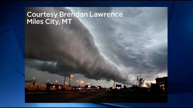 . While wondering why the sky was so bright green, a visitor from Oklahoma spoke up and warned us that we’re were about to hit by a tornado. I wondered.. the sky was dark gray yet bright green too. He said that there was a huge quantity of hail in the sky and that’s why the sky was green.
Then the hail started. We were in a small cafe in downtown Billings, but the cafe owner believed the report to “keep the door open for sudden pressure changes” The shop owner right next to us kept his door tightly closed. Sure enough, hailstones starting pummeling the street. Being the young 7 year old that I was, I rushed out the door against my parent’s wishes and got right into the hailstorm holding a newspaper above my head to deflect the hailstones. However I had NOT counted on the fact that when the hailstones hit the pavement they shattering and sent sharp fragments of ice everywhere, like a sand blaster. Hail fragments cut right into my lower legs, and I quickly retreated back inside the cafe.
We were astonished by the hail.. when suddenly we heard the crash of glass. Sure enough, the store owner who kept his door shut had his windows sucked out by the sudden pressure changes and his window smashed into a million smithereens onto the sidewalk and street. I thought to myself “wow!!”
Finally the hailstorm died down after about an hour or so, and my dad said “It’s time to go home (Laurel Montana)” so we all got in our car and headed down the highway. All of a sudden I spotted a black funnel wagging around touching the highway. I said to my dad “What is that??” I had never seen a tornado before. My father said “We’re not going to drive into that!” And he pulled off the highway. I watched as the funnel churned around and ripped things apart. The Musselshell Cafe we liked and visited, had its roof torn off. Numerous other buildings were damaged. You can read about this at https://billingsgazette.com/news/local/black-clouds-gathered-52-years-ago-before-first-recorded-tornado/article_7aadde50-7db8-11df-8c0f-001cc4c002e0.html
After getting home, we learned how bad the hailstorm really was. While the hail was not large sized, say a quarter in size, nevertheless the sheer volume and winds actually caused the hail to strip off every leaf from anything green, particularly in northwest Billings and surrounding areas. The hail was so strong that it even stripped the westward facing bark off the trees. I never knew hail could strip bark off trees, but that happened. Without their bark the trees died, of course.
After this disasterous hail storm, many insurance companies changed their policies and hail insurance was no longer available for Yellowstone County, Billings Montana area. In later years the lack of insurance, and yet continuing hail storms that hit every year in Montana meant severe financial hardship for the farmers.
Thank you Hector for writing this article on a memorable hailstorm. It triggered me to share my own experience.
One more comment which I forgot to put in my reply. The ground was turned white by the sheer volume of hailstones. It looked almost like wintertime, like snow covering the ground, but it was July 2nd, summer time.
Thanks for a fascinating story! And that photo is amazing. I am fascinated by storms, and am a member of a UK Storm Watchers group.
Meanwhile…we continue to wait for the fire-storm of Sunduknur….
Found something looking like a little tremor, but I am not an expert! The quakes I think it is associated with are just Southwest of PUHI. Right next to each other. If anyone has an different opinion let me know. It is also seen on some of the other instruments in the area.
2024-08-18 20:09:15
Earthquake
Magnitude:1.7M
Depth:0.1mi
2024-08-18 19:40:04
Earthquake
Magnitude:1.7M
Depth:0.1mi
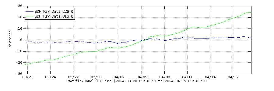
Kilauea showing strong tilting at SDH, and at Halemaumau. Pu’u O’o tiltmeter has levelled off but that seems to be because the magma has gone beyond Pu’u O’o and isnt tilting the ground there as much.
Pu’u O’o tiltmeter.
Also UWE tilt is higher than the level before the last intrusion:
The five years tilt shows that inflation after the February intrusion is steeper than ever during this time:
Yes every time I think it cant get faster it gets faster… I can remember back before the 2018 eruption, and commenting it on here as another name, about how crazy it was for an erupting volcano to inflate by 30 cm in 3 years. But the last year had seen the same instruments move apart nearly 2 full meters. And 0.5 meters in 4 months.
For me the part that is most ominous and potentially worrying is that there is nowhere on the volcano at all that is showing deflation. Magma isnt draining from the summit into the ERZ like I thought it would, it is filling with magma now rapidly but the summit is filling even faster.
It looks like the run-up towards the highly active period of 1960s-1970s. Each active period probably has its own characteristics, but something is awaiting us. Even if we get a weaker period than around 1970, it will be exciting.
The lack of deflation means, that magma is nearly everywhere now. The future allows a big variety of eruptions from upper SWRZ to middle ERZ. It also increases the probability that an intrusion leads to an eruption. The more magma is intruded in everywhere, the less space remains for purely subsurface intrusions.
We are already in a period of activity that is stronger than in the 1960s, 0.2 km3 of lava has erupted since 2020, same as all of the 1960s not counting the Kapoho eruption. Only slightly less than the total of Mauna Ulu too. And that is basically all within about 5 years of an eruption that was as big as Holuhraun.
No this really is pretty unprecedented, the magma supply already back in 2023 was as high as the record recovery after the 1960 eruption. And as you can see it only continued to get stronger from there… I never saved a picture of the GPS that showed the 2018 drop but I recall it was about 2.5 meters, about the same as the height of the graph now. So its not unlikely the full recovery of 2018 has now occurred at the summit. CRIM appears to be on a spot that physically moved not just elastic deformation, so is unlikely to be pushed back to its pre-2018 location. UWE already has exceeded its 2018 location…
I also realise now I misread tbe 5 year graph as the 1 year, but nearly 2 meters in 5 years is still crazy.
That one is only UWE, I was referring to the UWE-CRIM plot that shows caldera extension. But it is still pretty evident why there is so much activity now. 1.5+ km3 in 6 years, that is a crazy supply rate, at least 0.25 km3 a year.
There is maybe another intrusion going on, same area as last time near Pauahi crater. I dont know if it is a dike though, there isnt any movement at ESC tiltmeter, so it might just be magma pushing into the middle ERZ. I guess we will know soon enough, either the swarm gets way stronger and maybe even erupts up there, or uplift further dpwn the rift increases or moves east.
Actually, this is right at Pauahi, if there isnt a dike forming then the floodgates just opened to the middle ERZ. There could well be an eruption tonight though. Probably something like in June, but maybe larger.
There seems to be significant movement on the ESC tilt meter. The region of the current activity is just west of there.
Hard to tell yet if it is a quake or if the tiltmeter has actually moved yet.
It is looking like a large change where the blue and green swapped places.. but wait and see a few hours to be sure.
The activity seems focussed on Hiiaka crater at the moment
I see it now, still best to wait a bit to be certain but it isnt a complete vertical line like a quake would be. Seems there is an intrusion and in about the same place as last time, just before the ERZ bend.
But, the intensity of this one is much higher, if the tilt is actually showing this then it has plummeted, maybe the dike from a few weeks back was still viable and provided a head start. Its been nearly 50 years since an eruption in this area but theres a good chance that streak ends tonight.
Ok the summit tiltmeters are showing deflation, thats basically a confirmation of a new intrusion. But I also noticed something important that the movement on ESC is in opposite directions to last time, so actually it is probably a completely new dike not the old one reactivated.
This is a reminder that this is a volcanoblog, not a place to complain that the world isn’t quite right for you. A number of complain-comments have been deleted. We prefer to be grateful for all the viewing opportunities provided by Iceland, rather than complaining about them!
Further comments on this will not be accepted.
Been reading a lot of updates and articles regarding the current Reykjanes situation. Just wondered if someone could summarise the overall situation regarding the inflow and uplift. My main question is: has the magma inflow under Svartsengi remained approximately constant since the last eruption, has it fluctuated or is it lower, resulting in a longer build up? I saw several updates mention that there could be around 30 million m3 ready to go, so with every passing day the risk for the residents there seems to increase, rather ominous really.
The Icelandic Met Office has a Mogi model that estimates the volume of accumulated magma based on GPS measurements. That model showed an increase of the inflow immediately after the last eruption, but it shows a slowdown in the last few weeks. The slowdown has been interpreted as a sign that the pressure is rising and that an eruption is approaching. This assessment is also supported by the increasing number of quakes in the area. It’s probably only a few more days to go now.
Is this normal?
The þorbjörn one is at 1e-4, while Grindavík is at 1e-5. Either the tremors are very intense, there is a lot of wind or some kind of malfunction going on. I just look at it in complete shock…
Looking at the shake-map, it seems more or less dead in this area, almost as if there would be a storm/hurricane, but the wind is only estimated at 7m/s – and no rain at all.
Malfunction or intensity is high. If this was intensity, this is one intense continu-tremor, but like I had shown, it would have to show stronger spikes. Malfunction makes more sense, could be that they elevated the amplifitude to see more earthquakes, I guess? Then again, no new ones show up, like you said. Makes more sense if it was a malfunction, at least, of some kind. Maybe machinery as a possibility?
Anyways, looks like it’s calming down. We’ll either keep looking at the ‘grams or get some update from the IMO…
Nevemind, went back to its antics again.
The IMO charts are also showing noise. I suspect it could be construction work.
Look at the spectrogram for clues. For Thorbjörn it shows some very distinct spectral lines. Those are typically from manmade sources. There’s one source with a fundamental frequency of 15 Hz and an overtone at 30 Hz, and it looks like two sources at around 20 Hz with overtones around 40 Hz. A 15 Hz fundamental is what you would get from a four stroke engine at 1800 rpm and 20 Hz would be 2400 rpm. The frequency doesn’t change over time, so it’s not from moving vehicles. Probably some stationary equipment like generators. Digging and other construction noises would give bangs and scratching sounds. Those are wideband and raise the noise levels of the entire spectrum. Wind noise would do the same.
Could I ask something (even though I should somehow know this), but what frequency would the chart be (and color on spectrogram) would it be magmatic in origin? I only paid attention to the shakegram so far.
That would be the low end of the spectrum. A quick google search for eruption tremor spectrums shows that the tremor power is usually strongest below 5Hz. If it’s harmonic in nature the fundamental frequency is usually so low that you would not see distinct lines with the resolution we have in the raspberry shake spectrogram. Just look for something that has most of it’s power at the bottom of the plot.
If you go back to previous eruptions, you can see that it’s there if you know it, but it’s really hard to tell.
Okay, so look for anything yellow/orange at the very bottom during times of “silence”. May have to look back on the Raspberry site and turn on the spectrogram. Then again, you said it’ll be hard to see, so maybe look out for spikes rather than waves…
However, on the Vogar shakergram, I could see some yellow at the bottom if that counts…
And maybe the Krýsuvik one, too…

Ocean waves also end up at the bottom, so that’s probably from the Atlantic.
It’s also good to know that the graphs are autoscaled, so the colours change depending on the largest amplitude present.
Huh. I guess it is hard to see a magmatic tremor! If anyone could send some kind of screenshot of a harmonic tremor in action, so that at least we can see what to look for when a potential eruption is coming up.
I’m guessing the reason why the earthquakes are not showing up on the map (other than the big ones) is because if the noise from essentially anything but magma or tectonic movements, so it’s understandably hard to decern between volcanic or other tremor. Besides, machines need to do what they do, things always happen. At least there’s bigger fish to watch out for…
What you should look out for is that train of pulses from an earthquake swarm with M2 quakes happening every minute.
Looking at the accepted earthquakes at shallow depths, there are two areas that are active. First ca 1km S of Stóra-Skógfell (Good for Grindavik). The other is in between Þorbjörn and Grindavik, that would not be so good.
First magnitude 2+ quake in the Svartsengi area in awhile.
Time: 13:25:56 2024-08-19
Mag: 2.38 mlw
Depth: 5.338 km (take with a grain of salt)
Anecdotally, they do seem to be getting bigger. The activity from Reykjanes and Hengill is making it more difficult to see at a glance though, so it needs a bit of time spent to look properly.
I might be seeing things. Right on top of PAUD.
2024-08-19 15:43:17
Earthquake
Magnitude:2.4M
Depth:1.5mi
2024-08-19 15:22:30
Earthquake
Magnitude:2.8M
Depth:1.4mi
No this is real, there are continuous low level quakes now all the time at Kilauea. With how fast uplift seems to have just become we might see seismic activity flare up more. No idea on eruption location though, SDH is tilting the most on the upper SWRZ but there are few quakes there, its anyones guess
HVO is now showing less than 1 mag quakes on the main map page. Seems to mean they are expecting something, maybe?
Mac
Possibly, I wonder the same thing but there is never anything confirmed. I do take exact locations of those with caution, more just that they exist.
Earthquake swarm of 32 quakes last two hours around Pauahahi Crater (ESC Tilt), close to Mauna Ulu.
White Island currently does a continuous low-level eruption of ash up to 1200m high. How can a volcano keep an ash eruption like this continuously alive?
What eruption type is a continuous low-level ash eruption? It is too small for a Plinian eruption, but too stable for a Strombolian eruption.
Vulcanian?
Vulcanian eruptions are larger than Strombolians with big bombs and loud shock waves. Do they apply to explosive single events or also to continuous eruptions?
https://icelandmonitor.mbl.is/news/news/2024/08/19/seismic_activity_increases_day_by_day/
Looks like 110 earthquakes were recorded yesterday…
Maybe last video clip on Grindavik and the fissure location before the next episode: https://www.youtube.com/watch?v=pI7QHQLCGZE
The NASA Firms satellite indicates 3 cluster hotspots on the Svartsengi Crater row, approximately located at 63°52’26.4″N 22°23’28.9″W. I wish that there was some way to get some people to investigate these readings. The timestamp from the satellite is 2024-08-18 20:57:00 UTC.
That’s the coordinates of the main cone from the last eruption. Change the number of days to show in the Firms map to WEEK, then step back in time week by week through the calendar and you’ll see that it has been showing the same thing since the last eruption ended. In other words, it’s residual heat from the last eruption. Looking at a single day at a time you will find days where it’s not showing. That’s probably related to cloud cover and other weather related factors.
To verify that it is indeed weather that’s causing the variations, there’s another hotspot that can be used as a benchmark. Roughly 30km NNE from Reykjavik, at the northern shore of Hvalfjörður, is an aluminum factory that shows up as a consistent strong hotspot. On days that the Sundhnúkur hotspot disappears, the one at Hvalfjörður also disappears or becomes weaker.
Tomas:
Thank you for doing the legwork on this question. I appreciate this. I only noticed the hotspot yesterday for the first time which caught my curiousity.
There is volcanic activity today, Aug 19, 2024, detected by the NASA Firms satellite on a submarine volcano located at -18.99063 latitude, -174.76686 longitude, located SSW of Late Island in the Tonga region, Pacific Ocean, but I am having a very hard time of finding the name of this submarine volcano. This volcano has been active the past week or so. I backtracked and found that Albert located it as Home Reef, so it is still doing the volcanic thing. It would be very nice if the bathymetric charts would correctly label these submarine volcanoes.
You can download a kml file from global volcanism program that shows all of the volcanoes on their database 🙂
Chad:
Thanks for the tip. I will do that.
Found at https://volcano.si.edu/ge/PlacemarkLinks.cfm
https://www.aljazeera.com/news/2024/8/19/russias-shiveluch-volcano-erupts-after-powerful-7-0-earthquake article wording looks interestign on the timing of the M7 and the eruption of two volcanoes – anyone able to fill in the blanks a bit – with timings – presume the magmatic movements would have been an unrelated set of quakes ?
Errrr it started this eruption several hours *before* the EQ.
It remains an open question whether the EQ energy in any way modulated the style of the eruption that was already happening. But it seems unlikely; the EQ and the volcano are separated by ~400km IIRC.
Well – that answers the question I had! Large earthquakes can trigger minor eruptions (although landslides can also be misinterpreted as eruptions, and frequently erupting volcanoes are covered in material that slides rather easily ) but I had not heard of a significant eruption triggered in this way. So that remains true.
It’s possible that the earthquake was only a 1% factor of the eruption. If the conditions for an eruption already were at 99%, the big earthquake could have supplied the missing 1% to begin. I don’t know in which state Shiveluch was before the Plinian eruption. Was it already (nearly) ready to erupt? Maybe it only needed a last kick by a butterfly or an earthquake.
As Mike pointed out, the earthquake was very far from the volcano and the volcano erupted before the earthquake. So that is clear. Regarding the 1% effect, timing makes that very unlikely. You’d have to have a volcano just about to go big, and a large earthquake just before it would have gone. It makes more sense for a small eruption where a surface fracture could create a pathway for the eruption.
I feel like an earthquake big enough to set off a significant eruption would be a lot worse than the eruption.
Odd… an intense swarm where the Eldy system. Business as usual I guess.
Kilauea is having a swarm.
Approx. 42 quakes in the last 2 hours, including 11 over 3 mag. Looks like UWE and SDH tilt are dropping and ESC is mixed.
Mac
keep an eye on Hiiaka crater
typo in the last post, typed 11 instead of 1 quake over 3 mag. We just had another 3.3 over by ESC.
Mac
SDH tiltmeter.
 ?fileTS=1724158949
ESC with very steep reaction:
Earthquakes have reached to area between Pauahahi and Alo’i Crater now.
Looks like the UWE tilt is beginning to deflate suddenly…
(2-day live graph).
PAUD 6hr live
It is quite intense… possible eruption or migration along rift?
There is now clearly a new intrusion happening. It is in upper eastern rift zone, and the main ground movement is currently just north or northwest of the ESC tilt meter. The shallowest earthquakes were on the southwest rim of the Hiiaka crater, at the same location of the 1972 lava. At the moment the quakes are further east but not as shallow. There may be some deflation at the summit (not clear yet). The ESC tilt shows a 40 to 60 microrad jump from a source which I think is to the north of it.
KOcam, pointing NW, might be a good view of an eruption starts in that area.
Odd times right now. Kīlauea is showing signs of unrest (that may or may not lead to an eruption, as many times) and the Sundhnúkur fissures are likely prepping up for an eruption (we just don’t know when), so this a tough one: Kīlauea or Sundhnúkur?
Having two monitors on the computer, both! That said, with the better camera coverage, Iceland would be the most watched.
Mac
If I had to bet, I have a feeling Sundhnúkur might erupt first, as its eruption could happen at anytime basically, whereas Kīlauea might take hours for it to erupt, but then again, Kīlauea is very restless at the moment…
They actually have about the same style. Kilauea erupts very fast too, erupting within 2 hours of basically nothing weird in all of its summit eruptions. I dont think this intrusion will erupt now but it wont be long before another could start or this one could resume.
To be honest, I think the only reason we ever see Kilauea give warning is because of how intensely monitored it is.
https://www.sciencedirect.com/science/article/pii/S0012821X21004866
To keep our minds away from there for a bit, the article in question is about the filling of a pit Crater on Nyamuragira (very similar to Kīlauea’s filling episodes), where a block from a chilled lava lake is pushed up within the pit by more lava beneath it.
In Iceland at the moment and taking off soon, the volcano better hurry!
https://en.vedur.is/about-imo/news/volcanic-unrest-grindavik
New update on Sundhnúkur unrest… magma amount greater than previous eruption, two M2’s from last night. Nothing new, I guess.
“From now on, there is a high probability of a new magma run and even an eruption in the Sundhnúks crater series at any time.”
It’s so close, I can MET it! 🙂
Just to add to this, one can read something from the frequency of posts by the MET office.
A few weeks back we got a weekly update, then bi-weekly. In recent days they posted in a 3-day cycle, or three times per week. Now marks the first day we’ve had an update on the next day. That tells me more than the text.
If this eruption uncorks, I believe the amount of lava released is going to surprise us all.
Curtain of fire stage seems to erupt about 80% of the accumulated volume, roughly. What changes though is how fast, it might do that in only a few hours which is an enormous rate. 20 million m3 in 6 hours is around 1000 m3/s average but the peak rate is much higher. Since February each eruption has gotten more intense too so that 6 hours is probably too long, the bulk of the lava might be in as little as 1 or 2… Eruption after this point seems to just be base supply rate like at Fagradalsfjall, so somewhat unrelated although not a separate thing either.
Problem is where that first lava flood goes. If it goes east it will probably pond near Husafell and flow into the ocean, very rapidly I imagine through that narrow valley. But if it goes anywhere else its a big problem. In some ways having a long fissure might have saved Grindavik so far, none of the lava flows have been getting more than a fraction of the output. But it has also made it impossible to really predict what is in danger…
Kīlauea’s swarm seems to have calmed for now, deformation still ongoing though. Guessing magma is filling in the new space created. Calm before the storm or has this been another tease lol?
I think a tease, the drop at the summit was almost insignificant. Kilauea dikes are very fast, especially near the summit, if it doesnt erupt within a few hours while the swarm is strongest then it probably wont at all. Not a rule but pretty reliable for pressure fed dikes like this.
Lower ERZ dikes though, are not this way, gravity takes over there. 1924 was likely an eruption, a dive even found young lava in the late 90s but for some reason has never mentioned it again. Apart from that every dike that started east of Napau has erupted on land at least in recent time. The same is probably also true on the SWRZ, but it happes a lot less often there and not since the early 19th century.
Is this normal? Doesn’t look like machinery to me…
And it’s still going if anyone wants to have a quick peak…
Could be something. It’s not showing on the Thorbjörn raspberry shake yet, but it might be time to prepare the popcorn.
Yeah, it is starting to show on the Vogar though… looking though, there was one eruption where þorbjörn didn’t show any earthquakes but Grindavík did until a few minutes before said eruption started (maybe the March eruption? Or February?)
Sorry, is supposed be a reply to Tomas.
I’m waiting for earthquake locations to be updated in the IMO list. If they are happening in the right place, then this is go. If it’s the real deal we should know in a few minutes when quake data starts appearing in the lists (or lava starts spraying out of the ground). I’m not calling it just yet.
Agreed, but there is so many spikes that whoever is listing them might have e a hard time, so we’ll have to wait a bit longer to get a verdict.
A few events were aligned between Vogar and Grindavik. Those should be possible to locate. Whatever it was it has stopped for now. Cancel the popcorn and go back to waiting mode.
Besides that, looks like this little outbreak has ended and the multiview thing (from Live from Iceland) only listed the last “big spike” at 18:13…
Check the seismograph against this plot too:
Bottom half looks … interesting.
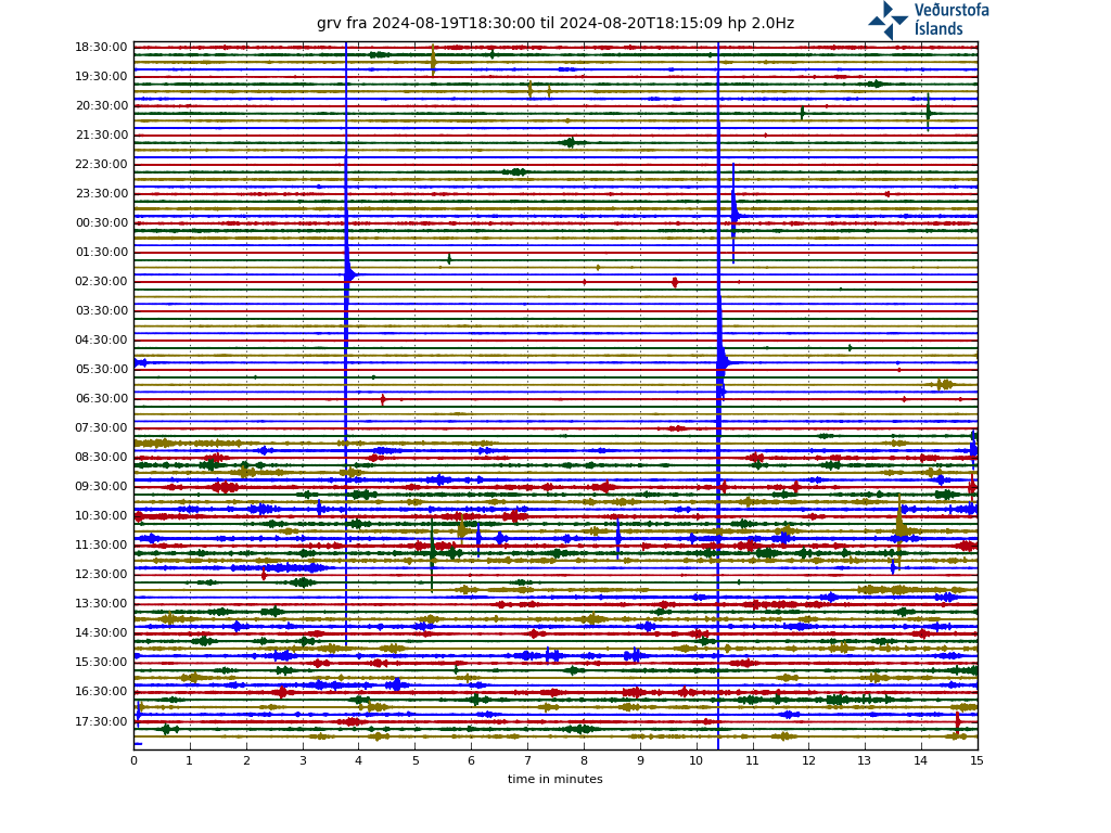
Could you send a link to the things? The links provided by VolcanoCafe here are broken…
The majority of blips are from the Eldey swarm. See how the waveforms seem to come in pairs? That’s the p-wave and s-wave arrivals. Each pair is a single event. P-waves travel faster but carries less energy, that’s why the second peak is always a bit larger. The separation between p-waves and s-waves tell us that they have travelled a distance before reaching the seismometer. For local quakes, they arrive at the same time.
The tremor and drumplot links on the Ongoing Events page still work.
However, as Tomas said, they are mostly from the Eldey swarm.
Not the drumplots… unless if I need a different website.
Check the times. This pattern exactly fits the Icelandic working day complete with lunch break. (And it happens on weekdays only.) This volcano is making itself at home already.
And exactly 8am, the tremor is back. This volcano is strict working-hours only. Carl’s discovery of the truth behind Etna comes to mind. https://www.volcanocafe.org/the-sicilian-affair/
Brother in Chrysler, the volcano already had its break! I needs to start workin’ to give us a show here! 😀
Sorry, it felt a little rude and feel bad, especiallywith that grammar error. Now back to waiting for eruption…
The link again with https removed:
vafri.is/quake/drumplot/grv_highpass_2.0.png
These grams are also accessible via vafri.is
Magma clocking out till next morning. 😉
Well, that worked…
The link thing from Steve. (Did the ting again).
https://www.researchgate.net/figure/Geologic-map-of-the-Los-Frailes-caldera-and-surrounding-area_fig2_30846801
Just had a magnitude 3.4 at Kilauea’s Upper east rift zone.
Seem to be expecting another glacial flood (Skaftárhlaup).
From IMO this evening: “Increased discharge and conductivity has been observed in Skaftá river by Sveinstindur. This indicates that a glacier flood is imminent in Skaftá, most likely from the western Skaftá-cauldron. The last flood from there occurred in September 2021 and they are usually smaller than from the eastern cauldron.”
Source: https://en.vedur.is/#tab=hydro
The Flood has begun:
White Island seems to be doing a fairly serious plume today. No further activity updates from GeoNet though.
https://www.geonet.org.nz/volcano/cameras
https://youtu.be/J1Sh75QuW2Q?si=1e4lFV1NzPmcO21r
Update on Kilauea by HVO. It seems like they think all of this is still early recovery from 2018, which is not exactly what it looks like to me really. Im guessing they are being extra conservative maybe to not give the wrong idea about the ERZ waking up.
Still, it was said 2018 was 15 years of lava, which was maybe true up to that point but to get the defirmation observed since then the supply has to be way higher. The comment that the ERZ hasnt had magma since 2018 also seems strange, there was a lot of uplift up to 2020.
They apparently try to avoid the orange alert level (Watch), prefer to switch between yellow and red.