A brief post from Nick whilst we write a more detailed post and to keep the comment thread under control…
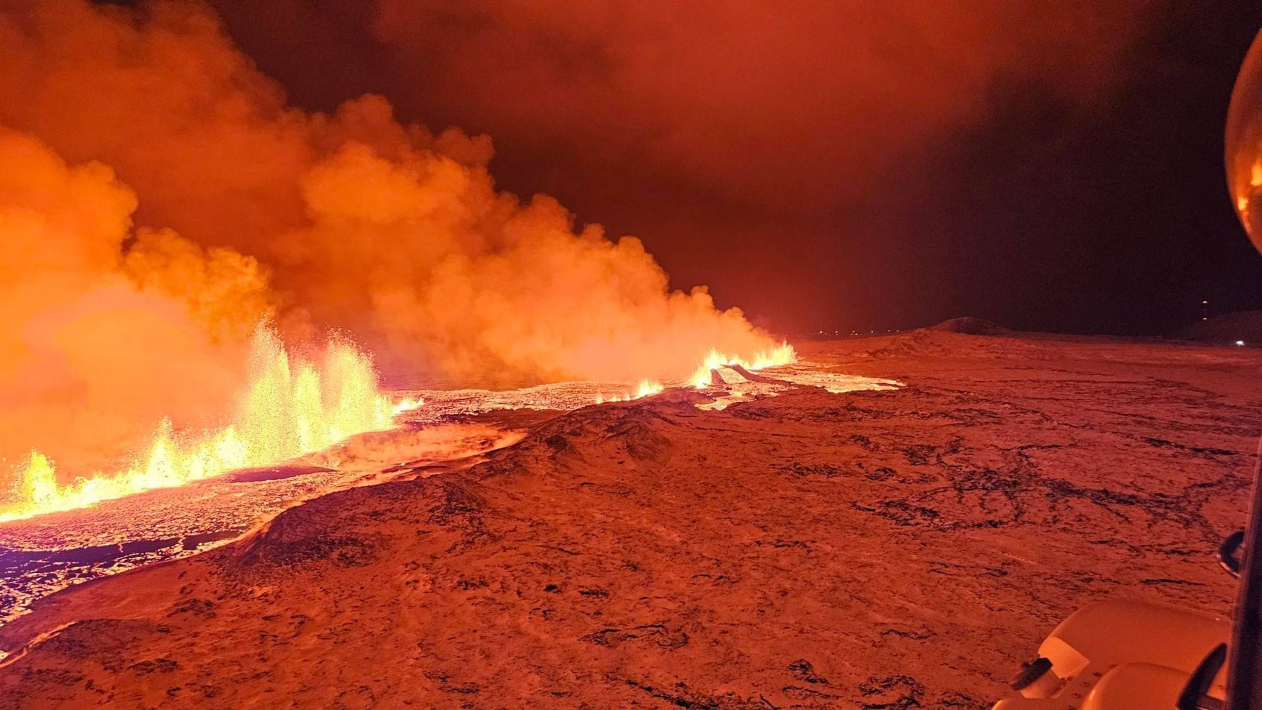
Image taken from the Coast Guard helicopter flight last night of the fissure eruption.
Just as my head hit the pillow at around 11 pm last night, my phone went doolally…
“ERUPTION.”
So I dived headlong down the stairs to wake up the PC that I’d only minutes before sent to its slumber mode. Thankfully, that’s all the travelling I had to do, unlike Isak Finnbogason, who packed his drone gear up and immediately set off to capture the unfolding drama. More of that later.
We weren’t the only ones caught on the hop. The Blue Lagoon had only just re-opened and discussions were ongoing about allowing the people of Grindavik back home in the next week.
But, thanks to the abundance of video surveillance tech in the area, this was probably about the most comprehensibly captured initial (fissure) eruption in history. Thanks to YouTube’s live feeds with timelines that can be scrolled back, most observers could watch the whole spectacle develop in “real-time.”
The first explosion in the vicinity of Sundhnukur was captured from the camera labelled as Thorbjorn. The initial phase seemingly has a phreatic component, presumably due to magmatic contact with groundwater. Ash soon fell on Thorbjorn.
A spectacular unzipping of the associated fissure followed along the old crater row… tracking a little way to the southwest towards Hagafell, but mostly to the (more benign) northeast. Pretty soon the fountains, approximately 100m tall at the highest pressure point, extended to a distance approaching 4km, with an eruptive rate of around 100 cubic metres per second.
Thankfully, most of the initial flow was easterly (though not entirely, there was some north western flow). As long as the fissure does not erupt at its south western end, in Grindavik, this is probably as good an outcome as could have been hoped for, in terms of sparing critical infrastructure. Luckily, the prevailing winds were westerly, blowing the voluminous clouds of sulphur dioxide away from large population centres.

Current map of the location and total length of the fissure from IMO.
There will be more detailed analysis later, but, in the meanwhile, some useful (and spectacular) links.
Topographic map of the area around Sundhnukur:
https://en-gb.topographic-map.com/map-gf51/Iceland/?center=63.86359%2C-22.38361&zoom=13
Start of eruption:
https://youtu.be/QcxaqCIon_Y?si=mvvIGjEOvV3LdNkT
Timelapse:
https://www.youtube.com/watch?v=ns5AgaMztOQ
Isak’s Drone Footage:
https://www.youtube.com/watch?v=I_mD-DWuwCM
More links can be found here at the ‘Ongoing Events’ page:
https://www.volcanocafe.org/ongoing-events/
Nick


Yes didn’t die yet but very small activity…
https://www.youtube.com/watch?v=tIh-TGrvajg from GutnTog
This definitely seems to be a different style of eruption. It started with massive lava flows but now the remaining cone, from what I can see in the dark, now appears to be building itself a cosy little cinder cone!
Interesting increase in seismic activity.
https://en.vedur.is/earthquakes-and-volcanism/earthquakes/reykjanespeninsula/
Geologist Shawn Willsey has an interesting session today discussing the current events – https://www.youtube.com/watch?v=MUgHIPSj_2E
Fun question just for fun. How fast woud Grimsvötn be icefree if Iceland was placed at equator? Im soure it woud go pretty fast, irradiation is rather strong in equator, 1000W/m2 so or more I guess it woud dissapear rather quickly. The smaller glaciers woud be destroyed quite quickly, the strange tought of floodwaters crashing from Vatnajökull, until there is nothing left there for the sun to destroy. The small icesheet in Trölladyngja shield may take only weeks to vanish
Souch scenario woud require a major shift in Earths spinn, where the equator is, which is impossible, still Earth can have dramatic variations in tilt as seen with one hair raising cretaceous event, still nothing compared to my silly tought experiment https://www.iflscience.com/new-evidence-the-earth-tipped-over-84-million-years-ago-61329
I have one question: when did spain take over the world? 🙂
1500 they were satisfied to get half of the world, and gave the other half to Portugal.
The Reykjanes multiview webcams seem to be zooming in on new areas of activity.
Looks like more activity has started .
All the recent lavaflows
It’s an impressive area. Is there an estimate of the volume for Sundhnúkagiga?
I don’t think there are any estimates on thickness, but IMO say the estimated size of the lavafield is 3.7 km2.
Based on eruption rates, the volume will be a bit less than 0.01 km3. That gives an average thickness of 2 meters or so – much deeper near the rift, much less near the edges.
Which means that if the eruption stops now, there is eruptable magma still in the system? & new fissures are likely?
There is a long chain of fissures and craters, where it’s possible that new ones arise. Towards Northeast this chain of fissures intersects Fagradalsfjall’s lava fields.
It was a bit of a strange one. The GPS showed a rather minor response. I think that not much new magma entered the dike at this time. The eruption was from the older magma there, which was pushed by gas (volatiles) perhaps released by reheating of some of the magma, or entering from the sill, at a depth of around 4km. This made the initial eruption intense, and across a long lineament. But after that initial rush, quite a lot of the eruptible magma was gone and the remainder a bit stale and reluctant to come out. The total volume that erupted this week was something like 0.005 km3. The original sill had a volume of around 0.01 km3. So I think the eruption ran out of fuel, and the tap to re-feed from the sill is currently turned off.
In Nov 9/10, the magma intrusion in the dike peaked within 6 hours, and after that exponentially declined with an e-folding time of 6 hours. This time, the event was much faster, peaking in 30 minutes and a e-folding time of less than an hour. That already shows that the sill was not as involved as before: this was local, and relatively shallow. The speed at which it moved to the surface was perhaps 1 to a few meters per second. To me, that again suggests it was gas-driven. It is also possible that the opening was created through phreatic explosions, so boiling of water below the surface, but although these explosions did happen, I think by themselves they would not have opened this long a rift. Assuming that the extend of the surface activity reflects the depth where it started, the earthquake activity at 4 km depth would fit well.
In my opinion, the dike is now dead. Resurrection will require a new feed. That can easily happen as the sill still has magma and still has a feed itself, albeit a declining one. The first Fagradalsfjal eruption went through a change when old magma ran out and after a short interlude a new more vigorous eruption started with fresher magma. But there is a good chance that apart from a few hickups, this eruption will not resume.
How much water does the magma contain there? It may play a role in the formation of an explosive steam plume during the onset of the ruption.
https://www.youtube.com/watch?v=VIs83vmfZCk shows very weak activity to the left side of the screen. The 4 areas to the right emitting flames were clearly the vents visible earlier. Is this a new development? Time stamp: 1:21:45 am Thursday 21-Dec-2023 Iceland time.
I’m amazed that as late as yesterday, while 100% sober, I ventured to describe any volcanic activity in this part of Iceland as entering a “steady state.” I do know better. In my career, I’ve tested flowing (not pumped or injected) exploratory oil & gas wells with depths of up to 6.5 km and shut-in surface pressures exceeding 20k psig. Some of these wells we described as high-pressure-low-volume. For weeks, I saw fairly exact similarities to those wells in the pressure buildup of this volcano. Here’s the thing: I knew darn well that the down-hole pressures and depths associated with these volcanos exceed anything I’ve dealt with by several (probably many) orders of magnitude. I could blame it on my ever-advancing old age, but truthfully this is the sort of mistake I could (and did) make when I was young and at the top of my game. I’m not depressed about it or anything — more surprised and even amused. Sum it up with a big
“sheeesh!”
On the Fagradalsfjall cam (recently renamed to the Sundnukar cam) I see that someone has built a nice, tame little campfire. There are other faint shimmering lights close by. Probably aliens.
https://www.livefromiceland.is/webcams/fagradalsfjall
The 2021 eruption maintained a fairly steady effusion rate for months. As, of course, did Leilani, and Pu’u O’o managed to do so for years. It’s obviously possible.
There is a complicated magma architecture underground. I expect we do not know enough about what happens down there to tell if the volcano will keep erupting or not. I think the supply was just redirected to open the rift at a depth, maybe below 5 km, and starved the eruption. To keep up with the opening shallow rift.
I wrote a nice segment on Ioto and it’s current eruption and the day that I finish is the day that it is reported that the volcano is no longer erupting…
In all seriousness, I think this is just a pause, the vent’s been going off and on for the last couple of years and with the magma intrusion not ending any time soon it’ll only be a matter of time
Ioto is a boiler that’s been creaking and swelling for a while, and now has popped a rivet and is whistling out steam from where it used to be.
I wouldn’t want to be within 100 km of it for the next little while. Except perhaps by remote camera.
Ioto has been rising at the rate of 1 meter/year for more then 10 years so the system so the eruption probably didn’t even release 1/10 of the magma that goes into this system yearly.
Yeah, Ioto’s inflation is in the ballpark of 0.01 km^3/year vertically longterm (though there will be downward component also). But it is several times faster at the moment (though that doesn’t mean anything necessarily, Ioto fairly steadily inflates long-term, but at the decades level varies considerably, much of the late 1900s saw basically no inflation).
I used to have that opinion but I wholeheartedly disagree now. Ioto is a massive volcano with a width of 40 km and an 8 km wide caldera. this volcano is a little bigger than Tambora. The magma chamber that feeds this beast must be massive. Assuming the magma chamber is even half the size of the actual volcano we get a chamber area of roughly 314 km2. With inflation rates on the Island I wouldn’t be surprised if this thing is getting more than 0.1 km3/yearIn most cases, the magma chamber is going to be way bigger than whatever caldera or stratovolcano is on the surface. The chamber area may be larger than 1,256 km2 which would make the intrusion even larger.
The current eruption is the first magmatic eruption in at least 1,300 years. Obviously, the current eruptions are being fed by the less volatile reactivated shallow chambers but this is a clear escalation in activity, and further escalations are possible.
The flames and the areas where they are have increased in number since my last post. I think this trend needs watching. See https://livefromiceland.is/webcams/fagradalsfjall. I count at least 10 areas now like small torches dotting the landscape, earlier there was just 4 or so which coincided with the 4 vents to the SSW of the south main vent.
There are dozens of small white flames so that it looks like Christmas carolers carrying candles at night. I guess methane or gas from heated buried organic material like moss is burning from the intense lava heat.
O wow what a hellish scene..looks like the plains of gorgoroth around Mount Doom, thats a sickly twisted burned horrid landscape that sits under a darkned ashy sky, sickly flames flicker in many cracks, some yellow, some green. The air is almost unbreathable and full of noxious vapours and corrosive essence. .. that steals your breath and ultimately steals your mind.
If Klyuchevskoi was in a warmer drier climate and more active and had these plains all around it, it woud be it the real mount doom. Some mafic Mount Doom like volcanoes with spectacular ashy lava fountain eruptions that makes for a sinister distant sight are Etna, Villaricca, Shishaldin, Pavlof, Hekla, Llaima. More sillic evolved volcanoes are also Mount Doom like even if the shape tends to get more lumpy. Many andesite cones and dacite ones, they are pure hell and perhaps joy of awe when they erupt, Calbulco was a very surreal sight in the night. Culturaly Hekla is the closest we gets to Mount Doom, greatly feared in entire europe in whole middle ages
The large old plinian eruptions at Etna woud also be a nightmare sight : ) one can almost see the Nazgul
Fire plains of Gorgoroth
I think that the flames are just remnant gases being burned as they exit the lava field. There seems to be only one small location spitting out some lava.
At 09:05 am, Iceland time someone flew a helicopter over the lava field surveying it, as the flames still continue. There must be noxious gas all over the place now.
And again a 2nd flight at 09:17 am, but flying a bit slower this time. I hope someone finds some commentary about this in the Iceland news today.
Someone with permission took a vehicle out live to look at the lava field now at 09:23 am Hope we get a report.
It appears to be dying down already …
Updated December 21 at 9:45 am
Scientists flying over the craters confirm that no eruptive activity is visible and that the craters appear to be extinguished, but embers are still visible in the lava bed. This was also confirmed by an Efla employee who is in Sýlingarfell. The activity seems to have gone down late last night or very early this morning. However, it is still possible that the lava flow is in closed channels and therefore it is premature to declare the eruptions closed.
Closed until the next episode. Any guesses when and where. If the ‘tank’ is still half full it wont be so long until the next session begins methinks.
I think the void may fill quickly again.
I saw the copters, the 2nd one actually flew so close to the main cone that I thought they were no more than 50 ft from it, they made a fast loop. It then examined most of the fissure linement but at a very close range, say 100 ft or so.
Does anyone have the link to the GPS at Svartsengi I have lost the link 🙁
Check ongoing events in the volcanocafe menu.
Thanks 🙂
Based on the Eldvorp and Skipstigshraun GPS, the eruption has removed enough magma to bring the stations down to about where they were at the start of December, more or less. So about 2-3 weeks ago, and what small amount of movemebt is visible since already shows an upward trend of similar magnitude to before the eruption…
My prediction is that another eruption will occur in 2-3 weeks, between the 3rd and 10th of January 2024, and nominally on the 7th. It will probably be very similar to this one but possibly in a slightly different location and potentially a bit larger.
Chad, I think the gas content of the primitive magma is the key player here. Obviously it was very high and unzipped a longer fissure line (about 4 km someone said) than most expected. I saw the unzipping occur from one of the early videos. Then we had high fountains, but things have remarkably waned, in just 2.5 days or so and this morning, the eruption is finished. When I saw the steam coming up from the fissure linements, based upon past performance of the previous 3 eruptions, I knew that it was finished.
I think that the gas escaping from solution is key to these rift fissure eruptions and the lack of the continual supply of this entrained gas from deeper source is why we saw this very short eruption now.
I agree with you, we’ll have bursts of short eruptions now. At least we are all learning how the fissure eruptions actually went, and can compare this to past Icelandic records. What surprised me here, was the fire field last night.. fires all over the lava field. I have not seen this before. I am sure that Icelanders saw this and wrote it down.
I estimated about 12 days last night, so a similar timescale.
Its doing a Krafla Fires very much, and it maybe so for a very long time with frequent eruptions. I gets the feel it will keep going for the rest of our lives, as the magma is just keeping to come in, now Iceland is monsteriously productive, and haves a large influx when its in a rift cycle, past reykjanes rift cycles have lasted more than a human lifetime. If the rate is at mantle decompression rates its truley monsterious, but its more likley its 100 s of years of accumulated deep magma, togther with some rift decompression in the mantle.
Krafla did shorter eruptions than the present Svartsengi one. But the pattern of repeated uplift/deflation, intrusions, earthquake swarms etc. reminds to the whole unrest period of the Krafla Fires. It’s possible that we get several intrusions that don’t erupt.
Might be a bit early to be conclusive but it looks like the system may be inflating again. A small increase in upward ground motion.
Link:
https://vafri.is/quake/
I use the GPS link at the top of the page on this site.
https://livefromiceland.is/webcams/fagradalsfjall did a very high zoom slow motion pan of the region around 11:55-12 noon and carefully scanned the whole fissure lineaments. Much to our surprise, there was a man dressed in an orange jacket perched right next to the hot lava on one section. The camera people zoomed right in on this man and watched him for about a minute until he disappeared from site as he got closer to the lava shutting down. This is very dangerous to be out in the lava field like this, but there he was. I took video captures but I was too late to catch this segment of the panning. The camera has amazing zoom capabilities, and for it to clearly see this man shows the zoom power. I am sure that they reported this to authorities. Somehow he figured that the lava was shutting down and zipped right out to see it for himself.
maybe a geologist sampling the lava ?
I hope so
RE: ” I am sure that they reported this to authorities” I doubt it. The experience of the recent past event, the blatant violations of the red zone, including the summitting of Litli-Hrutur which was forbidden, the lack of strict enforcement and accountability to same makes any expectation of change on the part of authorities dim. They were too concerned about putting the kabosh on the tourist industry. As I’ve said before, there’s no vaccine for stupid. Someone will have to be ‘cooked’ first, I fear, before ‘do not enter the area’ is taken seriously.
To compare it with Krafla I: “A minor eruption consisting mainly of steam began at about 1120 on 20 December. A small lava flow also occurred. The eruption was preceded by minor local earthquakes that began at about 1000. A 2-km-long fissure opened, and lava was erupted from three vents. The main lava flow lasted for 1 hour, and the eruption was essentially over by 1700 that same day.”
Krafla I was much shorter than Svartsengi I. Fagradalsfjall I was with six months the longest initial eruption of the three Fires.
At the same time the dormant period at Krafla before the Fires was around 230 years. Svartsengi 800 years? Fagradalsfjall 8000 years. So a long dormancy makes a long first eruption. And a short dormancy makes a short first eruption.
Has someone counted the hours of the eruption?
It began 22:17 on 18th December. Do we know the final hour? It looks to be around 48 hours until the evening of 20th December.
There was still some heating visible from the central vent at 7 am Iceland time this morning while I was watching it around 11 pm my time. I am not sure if this counts or not? We’d have to back up the Sundhnukar camera to find out when no more lava blobs were ejected from the cone.
This webcam still shows a tiny Strombolian vent inside the lava field:
20 years after the event is time to remember the – until now – most destructive geological event of the 21st century: The earthquake and tsuanmi on Christmas 2004 with more than 200,000 killings:
https://www.youtube.com/watch?v=4yFNOuo_YxI
How well is the observation of Tsunamis currently working in the Indian Ocean? They installed a system that promised to be able to warn, but would it help in a similar event?
This brings back very painful memories to me. My group was talking to 6 governments as we knew a huge quake was about to occur. Unfortunately one government misunderstood, called a false evacuation and blamed my chief technical officer on this miscall, thus setting science back 40 years. I run a risk posting this.
Jumping back to Hector’s post about volcano/weather interplay, here’s the latest stratospheric temperature, past and future.

As seen, the stratosphere has been running well below normal for the last ~ 2 yrs, which coincides with H.T.’s WV injection. Not a proof of anything, but worthy of note.
IMHO, the WV, via greenhouse gas processes, amy be setting up an inversion that’s inhibiting warmer tropospheric heat from rising past the tropopause/Junge layer. The cold air aloft in turn is creating a downward pressure on the troposphere where it’s altering both wind flows (jet) and inhibiting cyclogenesis (storm formation).
Got to be honest this eruption wasn’t what I was expecting.
Although fast blurts of lava are fun and look fantastic visually. Unfortunately I missed the first day and a half of it, which was pretty much the whole thing…
How long til the pressure increases again, do we have an up to date GPS of svartsengi?
There is a list of the stations from the Ongoing Events page, with a section for Svartsengi/Grindavik.
Above, Chad estimated 2-3 weeks. Last night, I counted 16-17 days between the level after the eruption and the equivalent previous level. That would give us 12-13 days, but that is based on the deformation continuing at the same rate as before and that it follows the same sequence, which is a big assumption.
Side note. The last time this region was active it lasted about 80 or so years Fagradalsfjall was the start….this is just act 2.
I wasn’t able to access the tremor plots for a few days, until last night. All the nearby stations clearly show the point of eruption and on the Grindavik plot, there is an increase in 2-4 Hz for about 10-12 hours, followed by a sudden drop immediately before the eruption and the big rise in all frequencies, which probably represents the start and the sudden swarm for the 90 minutes before the start.
Does anyone have a location for any swarms just prior to the start of the inflation? I’ve been trying to triangulate the GPS movement and that puts the centre of the inflation in between the GRIV, HS02 and SKSH GPS stations, with HS02 probably being the closest. This is around 500-1000 metres west of Thorbjorn.It would be interesting to see if there was any seismic acitivity centred around the same area.
Richard:
Can you find the geolocations for the GPS stations? This would help greatly, then you can use the IMO chart and try to match the LLA (latitude/longitude/altidue) locations of their quakes agains the centre of inflation.
1. Calculate the actual LLA of the inflation centre.
2. Look at the IMO table of quakes.
3. Plot a map and take a look
Unfortunately, I don’t know the geolocations, so it wss fairly rough, based on the IMO map of their locations and relative movement, visualised in my head.
With more accurate data, it could be pinned down better. The HS02 station is a new one I think, so I’m guessing it is located where it is for a reason.
And still going on Mars Ingenuity completes Flight 69
I did 2 videos from this morning. I did catch the scientist taking their look-see. In the 2nd video, some sightseer man was playing Truth or Consequences, but I missed capturing it. The Live-from-Iceland camera man was as surprised as I was to see this guy right next to the steaming fissures. See https://youtu.be/5CTYF2M7xOg – Timelapse video and https://youtu.be/1FtrPZaJJCo – High Definition scan of fissures
The same person news reported as “would have died” if they hadn’t rescued him?
There’s a town called Truth or Consequences. Incidentally it is surrounded by volcanic fields.
I know it well. Everyone calls it ‘T or C’.
Btw, here’s the 4-hour plot of the Svartsengi GPS:
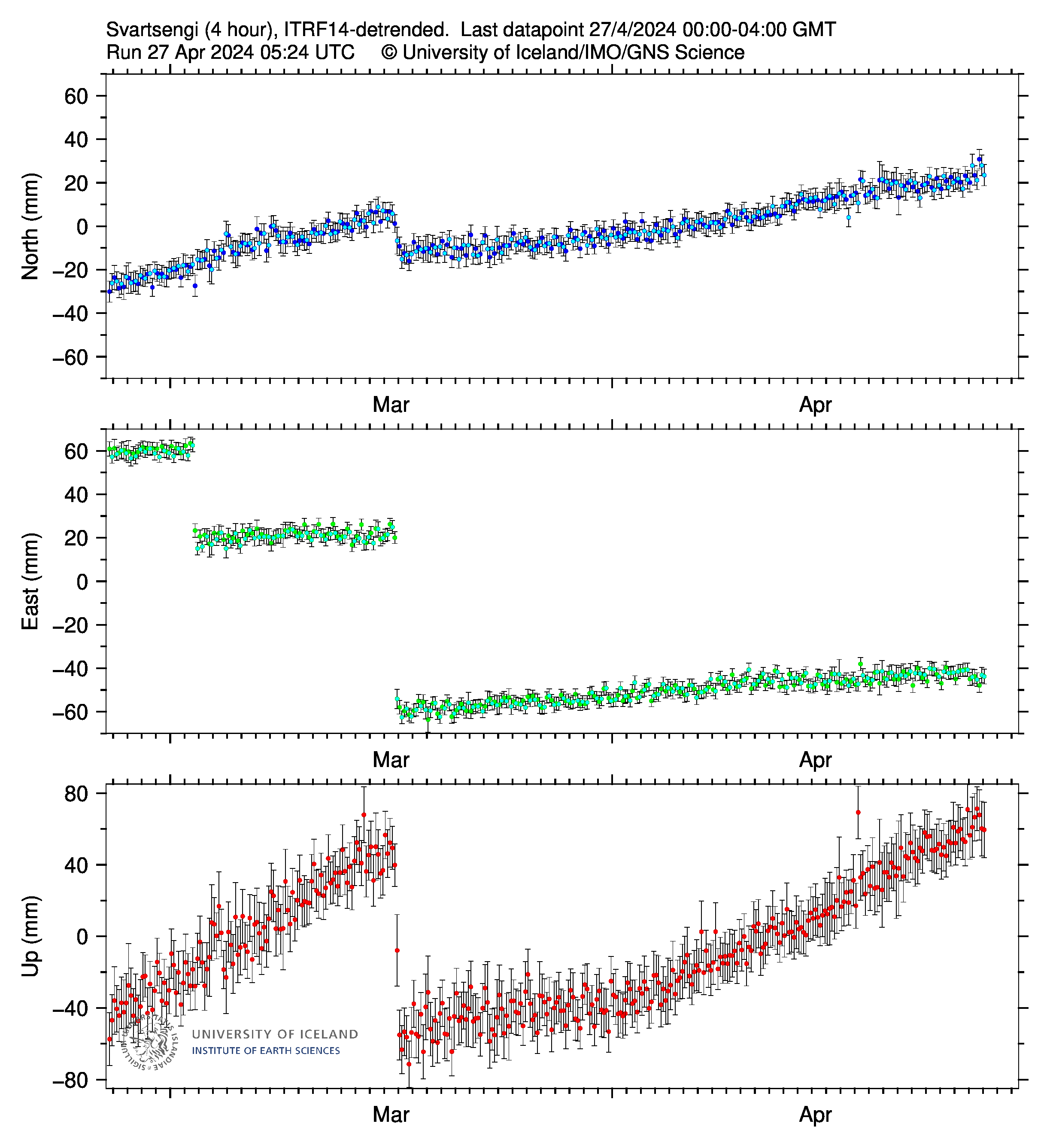
The plot that’s available from IMO or vafri.is lags 24-48 hours behind:

Interesting that with the eruption the station moved even further north and west while the land dropped. But come to think of it, that seems expected – if a bulge flattens its outer edges will move further away from the center of the bulge. Or could there be other reasons?
Forgot to insert the link of the coarser, less up to date plot:

Apparently the site eats that link because it’s “not secure” so here’s the link without http://
brunnur.vedur.is/gps/eldfjoll/thorbjorn/SENG-plate-90d.png
Possible recalibration? It will also depend on where the feed from below is. I think the sill is to the SSW of Svartsengi.
SENG is still moving along. Just like Chad said, more action soon. I wonder if we have deep siphoning with entrained gas helping out, so that we get just enough gas pressure for one short eruption at a time. Think of it like the geyser action of the very first eruption with cone #4.
Thanks to those who replied to my earlier question on the most productive hotspot, I didn’t get time to reply back then but much appreciated.
Interesting to see lots of seismic activity this morning in Reykjanes now that the conduit is (mostly) closed. Looks like the magma under Svartsengi is annoyed that someone slammed the door in its face. Episode II can’t be far behind.
I would also like to add that there have been some who suggested that the source of the magma lies somewhere under Fagradalsfjall where it rises and moves Westwards to recharge a storage area somewhere near Þorbjörn, it’s interesting to see among the seismic activity this morning, a series of relatively small quakes at 5-7km depth leading from Fagradalsfjall SW exactly in that direction, somewhat parallel to the recent eruption site. Perhaps I’m wrong to think the quakes are related to this movement but interesting nonetheless.
That is the big question. Svartsengi and Krysuvik are the two presumed magma sources. Fagradalsfjall would have been considered part of Krysuvik (had it erupted in the previous fires) and the flows in the Grindavik area are considered sources from Svartsengi. There is a slight difference in the composition. But that distinction is now in doubt. I am not sure that the concept of separate volcanic centres is that useful here. It will be interesting to see the full analysis of the lava.
I have a prediction for 07/01/24 as the next eruption, in about 2 weeks more or less 🙂
To me the volcanism of Reykjanes, going from Eldey all the way to Hengill, it really looks like basically a single system. Its not one volcano per se, because it is open to the mantle along the bottom everywhere, but having the element of transform faulting seems to be important and does distinguish the area from standard MAR volcanism. Also notable that while the area is cyclic eruptions near the end of Reykjanes in the ocean are known outside the cycle, while Hengill at the other end doesnt even erupt every cycle. Hengill does do larger eruptions than those at Reykjanes and Eldey though, so possibly the rate of magma production is not too different.
It is also still a massive unknown how the true statigraphy of older lava around Hekla plays out. The major ash layers are pretty well understood but there are many large effusive flows in the area both from Hekla and Vatnafjoll. These volcanoes sit at the other end of the Reykjanes transform fault basically, its called another name over there but its arbitrary really. Hekla woke up historically during the last Reykjanes cycle, it makes me wonder if larger eruptions or those nearby to it are indirectly related to the movement at Reykjanes.
We are going to learn an enormous amount about Icelandic volcanism this century. Not for lack of trying but I suspect we have got a lot wrong.
Svartsengi might be for Fagradalsfjall, what Grimsvötn for Bardarbunga. Gjàlp 1996 showed a link between Grimsvötn and Bardarbunga. Also the peak activity 1996-2015. Now Svartsengi and Fagradalsfjall have begun an active period like that, but we don’t know how long it will last and when the peak of activity will be. Fagradalsfjall has until now behaved like Piton de la Fournaise with small shield volcano eruptions, that are unlike the episodic fissure eruption of Svartsengi.
Svartsengi and Reykjanes are likely like the short fissure eruptions of Mauna Loa (1975) and Kilauea (f.e. 1982)
I will be most interested to see if Grimsnes/Hengill systems wake up. They seem…more complicated.
Hengill is like Svartsengi but bigger and more mature. It even erupted non-basalt lava in the Pleistocene but not recently though. Basically its like a bonsai Bardarbunga 🙂
Not sure if Hromundartindur is apart of Hengill as a large structure, its only eruption postglacial was an evolved basalt cinder cone so not easily comparable.
Grimsnes seems to be kind of between a fissure swarm and a standard amorphous volcanic field. It has large cones too, the area around Hekla and Katla has similar large pyroclastic cones but they are rare elsewhere in Icelabd. So Frimsness might have similar eruptions to the one in 2021.
The short eruption clearly fizzeled out, but there is clearly more in store going forward.
With a new small EQ-swarm along the dike today I can not help but noticing what seems like a second “tunnel of love” (looking at EQ’s) parallell to the dike just slightly to the east of it. Anyone else who has noticed it? A second old dyke that fills up? Coincidence?
It shows quite clearly at the https://vafri.is/quake/#close map (default setting) zoomed in to show the area incl. Keflavik (N) to just south of Grindavik. Not that those two locations are N-S relative to eachother, but only to reference the zoom area. Roughly.
I do hope and wish everyone in Iceland (incl. family) will have a quiet peaceful holidays season. To everybody frequenting, contributing and sharing their knowledge here on VC; A very merry coming Christmas!
All the best from winter wonderland 🙂
I see it too. It’s clearly deeper with quakes ranging from 5 to 9 km depth.
Could also be a fault line that’s rearranging now that the pressure nearby has changed.
There’s a third line now.
https://en.vedur.is/earthquakes-and-volcanism/earthquakes/reykjanespeninsula/
The Fagradalsfjall dike apparently wants in on the action. Some activity along that line over the last 48 hours.
If this system becomes like Old Faithful and provides enough time to create more barriers close to Grindavik, it could become a decent tourist volcano after all. Of course the viewing area will have to be much further away than Old Faithfuls, but the show is a heck of a lot better (and warmer) as well. Be nice if it could pay for the complete repair of Grindavik.
(from the guy who was yapping about steady states two days back)
Old Faithful is pretty steady, come to think of it.
There’s still the risk for a Goma event, that a lava fissure opens close to Grindavik and lets a lava flow quickly rush there. Fagradalsfjall showed a migration of eruption spots towards the north. If Svartsengi does the same, it’s the best solution for Grindavik and other settlements.
All in all the eruptions there will be too big and dangerous for a tourist eruptions. But after the eruption, the lava fields and structures may become exciting tourist spots like Eldfell (Heimaey), Krafla or Askja.
The eruptions at Fagradalsfjall moved north because the source was north of the mountain. Supposedly it is near Keilir but im not sure it is really so focussed on a small location.
By analogy the ‘center’ of the current rift is pretty much at the southern end of what erupted the other day. So it is about equally likely to go south as it is to go further north than it already did. Probably most lava erupted will be close to the existing vents but small vents could open further out including near Grindavik. I dont think a major eruption will happen immediately adjacent to Grindavik.
There is a line of Holocene craters and fissures that begin close to Grindavik and continues until the northern slopes of Fagradalsfjall’s lavas. So there is potential for Fires all the way. The first eruption (Svartsengi I) was in the southern part of the line. The next eruption can move south, but I’d expect that the majority of the Svartsengi Fires happens between the present location and Kalffell in the north.
Is the Svartsengi I fissure a monogenetic one or can it open again during the Svartsengi II?
Rifts are ‘monogenetic’ but while active all tend to be in the same place. Krafla fissures in the 70s and 80s were all mostly in the same line even repeatedly. Mauna Loa has erupted from the same fissure across its summit at least 7 times in the last century. Hekla has used the same fissure more or less since it formed.
Its also hard to call these rifting locations truely monogenetic because often the area that can easily rift is narrow and will have inevitably erupted in that location at some point before. This is the case in all the above mentioned locations. Monogenetic cones clasically are like Paricutin or Sunset Crater and arent rifting events, those happen in vast volcanic fields with very little complex structure by comparison so are a lot more random in distribution as expected.
One can also consider that stratovolcanoes form over short periods where eruptions are frequent for a long time, and if the volcano goes dormant for a long time the new eruption is often not at the central vent that created the original mountain. Santa Maria is the best example I can think of for this, it wasnt a caldera formation like many VEI 6s, seems it was instead a formation of a new open vent that is building a new stratovolcano albeit a dacite dome complex rather than a mafic ‘perfect cone’ type volcano.
After the lava flood comes a winter storm flood: https://hooge.de/aktuelles/heute-auf-der-hallig/webcam
The island “Hallig Hooge” is flooded by North Sea, and the artificial hills which host the houses, appear as tiny islands inside the sea. Historically there were many destructive storm surges which let the water rise into the settlements and destroyed the houses where humans and cattle tried to escape somehow.
That‘s so nice. How humans tried to organise their environment around them since ages…
In the North of the Netherlands we call these little hills „terpen“. Manmade hills to survive the floods.
Yes, it must be scary to live on a small house yard with open sea all around. This doesn’t happen often, so it’s even for the inhabitants an occasional event. Usually the storm surges are low enough that the water doesn’t reach until the Houses. But desastrous storms 1962 and 1825 rose so high that they destroyed the houses and farms.
On these islands the population is small enough that the house hills (“Warft” in German) are preferable to dyke solutions. Something like this would also help against a lava flood, but it is clearly no solution for the Blue Lagoon …
The Hallig islands lie mostly in an area where during the Middle Ages was a big island “Nordstrand” that collapsed during a catastrophic storm 1634
Different names were also used. ‘Terp’ is frisian, derived from ‘dorp’, which is a generic word for any village: it is not clear that the word referred to the artificial mount. ‘Ward’ or wierd’ (as in ‘Bolsward’) was in use for them. Terpen were build throughout the Netherlands, but they have only survived in the north. The northern terpen region failed around 300 AD when sea sediment had build up the coast too high and water would no longer drain out from the region. The whole area became a swamp and people left. It was repopulated a few hundred years later, presumably when drainage was re-established.
Foot is not getting better.. or worse, hopes the next reykjanes eruption can distract my tougths
At least not worse…
Wishing you all the best and speedy recovery Jesper!
Get well soon Jesper, hopefully you’ll be back to climbing Etna/Kilimanjaro/Idunn Mons in no time.
From the IMO: “According to GPS and satellite-based measurements, ground uplift in the Svartsengi region was apparent immediately after the eruption began on the evening of 18 December. Initial measurements show that the rate of uplift is greater than before the eruption occurred. This signifies that magma accumulation continues unabated beneath Svartsengi.”
This could be the result of a vacuum being created and hot gas-rich magma rising to fill the gap. Or perhaps the older staler magma was causing a bit of a blockage and a throat clearance needed to happen to open up space.
The takeaway is this:
“The probability of an eruption therefore increases with each passing day.”
So now it’s the exact opposite of when it started on Nov 10th where the likelihood decreased with each passing day.
I’m guessing this means it won’t erupt again for several months? 😀
In typical Iceland fashion, probably. I think it depends on how much strain the crust can hold having just been broken through. And also whether or not it reestablishes a connection to the dyke, or a parallel dyke, sooner rather than later, instead of just inflating the deep sill. But the GPS above doesn’t show that big of a drop compared to earlier in the month, where it appeared to empty into the previous dyke. So this recent eruption may have been the tip of the iceberg, or even the smallest, with the rest still to come.
No the situation is like this
The inflation has almost always increased ever since the whole thing started. Except that inflation slowed a bit prior to eruption and reverted briefly at start of eruption.
But now inflation resumed. Magma.is still collecting under Svartsengi and adding pressure. It will erupt again at some point, somewhere
Most likely in about 3-6 weeks and near Hagafell.
The situation at Chiles Cerro Negro is getting weirder and weirder the more I look at it. For October, August, November, and December, there is only one active week at the beginning of the month, and then the rest of the month is quiet. From August to October, inflation accelerated to 21 cm/year, and from the wording of the SGC’s November report, it looks like it is still accelerating. It never stopped or slowed down after the swarm earlier this year. There was persistent long-duration volcanic tremor in November along with a large spike in fluid-based quakes. I am genuinely confused about what’s going on, I thought disturbances to the hydrothermal system were the cause of this swarm but that no longer makes any sense. The hydrothermal measurements show weak unrest, not enough to explain the inflation rate doubling or the modest quake activity
The IGEPN’s seismograms and other volcanic monitoring instruments were vandalized in October.
I always wonder why people would want to vandalize that sort of equipment, same thing happens in the DRC with Nyiragongo and Nyamuragira. I know it’s usually politically motivated but the only thing it does is endanger civilians and it doesn’t make anyone look any better.
I think usually it was something to do with selling of parts. If people in the area are willing to do poaching (very few but still not 0) of rare and dangerous animals to make a living a random box full of expensive metals, as well as a solar panel and a battery, its a treasure chest.
As if re-opening the Blue Lagoon wasn’t temping fate enough.
https://www.ruv.is/frettir/innlent/2023-12-22-grindvikingar-mega-vera-heima-um-jolin-400607
Meanwhile IMO says
So according to that the police reduced the hazard level but IMO says there could be little to no warning, the hazard level remains considerable and the risk is increasing.
Oh wow. Let’s hope they have a white christmas, not a glowing red one.
New IMO hazard map in English
It’s like Hawaiian Ocean View on ML’s SWRZ all over again.
One has to ask…why? They aren’t exactly going to have the deccies up and a full roast dinner inside their houses. If they haven’t got everything they need out by now…
It really is a headline waiting to happen. I definitely think a breakthrough just north of Grindavik is still possible.
May be someone is needed in the vicinity to check on e.g. the power station?
If they pull the same trick over New Year, they’ll definitely be pushing their luck.
playing with fire would be the words I would use!!!
My counting back to similar inflation would put the next potential date as 2-3rd January, but I could certainly imagine midnight going into the 1st.
It could be sooner, if the current rate of inflation is maintained.
Does the sill enter a period of real dormancy soon or is it going to be (hyper)active continuosly with many sudden possible eruptions anytime?
Based on the activity in the 1200s it might stay active for decades. Back then it seems to have done fewer large eruptions, but now might be frequent small intense eruptions. Or it starts off smaller and frequent but moves to larger and more widely separated eruptions. Perhaps if eruptions are frequent or particularly large a more permanent hole could be melted out and a singular vent making a lava shield or large cone could form, but this would be uncharacteristic. I dont know if judging anything other than a long timescale is appropriate now though. 4 eruptions in 3 years never happened in the last cycle as far as I can find. I also wonder if maybe the last cycle starting at Brennisteinsfjoll, where most of the lava was erupted too, if those factors are related. Maybe the first area to erupt gets first dibs on the magma and erupts the most. Which is certainly very bad news for Grindavik… Or maybe we just took the middle ages reports too directly and they are not nearly so reliable to infividual events as more recent records.
The same is probably true still of Fagradalsfjall, it might be active for the next 20 years too. If that is the case then that 20 years could be one for the history books.
Concerning the activity in the 1200s I’ve doubts how accurate the reconstruction is. There can happen scientific mistakes when they do the list of historical eruptions. The Fires are very long ago. Vegetation and aging of lava flows/tephra can hide some eruptions that happened but aren’t observed until now. If there were many small eruptions (like the current one) followed to each other in a short time period, it may with large temporal distance appear like one big lava eruption.
I think that the unzipping of the ground was way beyond what anyone expected. I understand the “experts” concern. Basically we hardly know anything, really, and we are just trying to find out who might know something, but our ignorance is obvious to all. I think a balance between caution and how reality actually works is needed.
The concern is how rapidly events can occur. There was only an hour from the start of the swarm and the eruption. That gives very little time to issue an alert and get everyone out.
Not to be that guy but I have been saying an eruption here will be crazy intense in basically every article of relevance… The bit I am more surprised by is how fast the recovery is.
They don’t think that many will spend the night in Grindavík. Let’s hope they are correct. But just in case, hope they keep a record of who does so they know who to check on, if the worst happens.
If I was planning to spend the night there, I would have the earthquake maps open at all times so if a swarm starts again, I could get out fast. As IMO implies, there may not be time for an official alert to go out in time.
New eruption at Lewtobi.
I’ve asked before, rhetorically really, what the mechanism is for this volcano to erupt — considering the previous eruption and the next. The question refined is, does the rising magma have to overcome structural blockages — or — is it the simple hydrostatic weight of the magma that must be overcome. I know it’s both, but I bet one factor predominates.
The next eruption could test this. Unlikely, but it could. I’m thinking any structural components have been cleared by the previous eruption. So if the next eruption waits for Svartsengi to inflate to the same elevation as the first eruption, it’s the weight of the substance erupted (or its gas content — same thing). This is analogous to using increasing weights of brine to make a troublesome gas well behave itself during completion or workover operations.
If it erupts before that previous state of inflation is reached, then removal of a structural impediment during the previous eruption might be in play.
I’m heavily leaning towards it erupting at the same level of Svatsengi inflation. I know this might be a wholly inadequate test, but I’m retired and this gives me something to think about.
The way I see it – a very non-expert view – is that magma is rising under Svartsengi. This caused the ground to fracture from Grindavík to Stóra-Skógfell November 10th, resulting in a magma intrusion there; magma may have flowed from Svartsengi to the fracture (as indicated by rapid deflation). Magma continued to rise under Svartsengi resulting in resumed uplift. When the same level of uplift as November 10th was reached, the ground fractured again in the same location as November 10th, resulting in an eruption this time.
Magma is still rising under Svartsengi. It is likely that there will be another eruption. If the location of the November 10th fracture is still the weakest point in the system, the eruption will likely occur in the same location. If it isn’t, the eruption could happen anywhere in the Svarstengi system.
I guess I am looking at the constraining pressure of the ground around the Svartsengi system.
Im glad you included this bit. Are you saying that the fractured rock heals itself between eruptions somehow? So that it takes the same pressure to get through it as it took for the same eruption?
I don’t consider that impossible or even unlikely. I think a mass of rock 400 meters thick could seal itself back together once there is no longer anything pushing it apart. That does complicate my test. But that’s okay. I didn’t have a lot of faith in it to begin with.
Dang it. “same eruption” above should be previous eruption.
No. I had not considered that. I think that magma would erupt at the weakest spot.
Earthquake activity may have weakened more areas than just the current eruption site.
I have the feeling that Svartsengi is like Mauna Loa during the first hours of Mauna Loa’s typical eruption: A long Curtain of Fires that splits the whole volcano over a long Lava Fissure. After this Curtain of Fires Mauna Loa usually migrates the eruption to a certain location, either on the summit, on SWRZ or NERZ. Svartsengi has run the Curtain of Fires more or less until the Fire runs out. It hasn’t migrated as Mauna Loa would do. But the first hours, the onset, the beginning is very much Mauna Loa style.
In this view, the new born sill below the fissures of Svartsengi may behave like Mauna Loa’s magma chamber. When it is loaded, it does eruptions very quickly, sometimes suddenly and always with an impressive Pyro show that exceeds the typical Kilauea/Piton de la Fournaise eruption onsets.
This is a ‘just in passing’.
Decades ago one got the impression that it was magma forcing up the mid oceanic ridges that caused separation of the continents. I actively disbelieved this because the physics made absolutely no sense. Then (at the other end of the continent) the massive falling subducting slabs were discovered and the mechanism (to me) became very clear. The monstrously massive heavy falling slabs were dragging the continents apart. Gigatons per m of rift, a LOT of force.
Of course this is exactly what we see on a crucible of molten steel & etc .
So the vulcanology of iceland is really just the crust opening and the only thing to fill the gap is magma. Not under any particular pressure, just gap filling. Of course at the surface the magma is not in equilibrium and the many happily dissolved gasses precipitate out and cause the sort of vulcanology we see here, a rapid rather mild eruption that ‘quickly’ expires once the gas has vented.
Complications arise when the magma and gasses do not vent but accumulate in chambers and fractionation and large unstable volumes arise. Tthat’s a quite well understood mechanism that unfortunately has disastrous consequences on occasion.
Here we have the simple version….
There are mantle plumes that help push the plates apart.
There aren’t any big active subduction zones on the North American Plate and Eurasian Plates; other plates subduct under them.
Plumes may burn through a plate, or uplift due to density difference if magma boule is big enough (or both) but not to split a plate on their own.
The north american plate is being dragged westwards due to the pacific plate subducting beneath it. OK I was simplifying but the essence is the driving FORCE is subduction, not upwelling (as a rift its passive).
Not to say that a plume cannot influence where the rifting first occurs.
We discussed the four forces that drive plat movements in https://www.volcanocafe.org/the-dancing-earth-continental-drift/. Of the four, slab pull (the pull from the subducting plate) is by some margin the largest force.
Hi Albert,
sadly I just get starry sky on that link (maybe it will load later).
I cannot remember that topic, did you put actual figures against the various mechanisms, as I am sure we have enough information to get a decent numerical estimate (to the usual order of magnitude or so).
I would say most people, and even many here, believe that slab drop is not the major cause although IMHO a back of an envelope (and a look at the world map) quickly shows that splitting tens of km of rock (even if fractured and a crack initiated) requires immense force.
It is the Dancing Earth post. It states the following:
“But what is it that makes the continents move? The main action is clearly in the oceanic plates. But what force can make the surface of the Earth drift? Physics tells us that there are four different processes at work. In increasing order of importance, these are:
Magma injection The magma injected into a spreading ridge can push the two sides apart, and set the plates in motion.
Convection currents The convection currents in the mantle can themselves induce horizontal motion, because upwelling and downwelling occurs in different regions. The flow in the mantle can drag the crust along.
Gravity Spreading ridges are pushed up by several kilometers. Subduction occurs in deep trenches. Gravity causes material to move from high (spreading ridge) to low (the trench). This is called ‘ridge pull’. (It is also called ‘ridge push’ but this is misleading as there is no push from behind.)
Subducting plates As the slab sinks, it pulls the rest of the plate with it. This is called ‘trench pull’ or ‘slab pull’.
Slab pull is now considered the most important effect, followed by ridge pull. Horizontal convection currents in the mantle would affect the continents most, since they have deep keels sticking into the mantle, but this is not observed. Instead the continents seem to respond mainly to the oceanic crust. Ridge pull is important, but magma injection by the rising mantle, which would seem to be the most obvious way to drive plates apart, does not work as a force.”
In my recollection, slab pull accounts for 75% of the force. I would need to look this up. Obviously, in local areas there may be differences. Turkey is pushing part of the Mediterranean westward – that kind of cascade effect is not included but on th elarge scale of things, it is a secondary effect.
The Pacific Plate subducts at the Aleution Trench, otherwise its only other boundary with the North American Plate is a transform fault.
Interesting. One line of discussion is that the trench was stationary and that North America ran over it, forming Washington State and Oregon as they were accreted to it.
From this concept one might expect that the far far distance future will see Iceland with a huge rift valley, having been pulled apart by tectonic forces. Haven’t got time to wait for that one.
That will only happen if the extra magma productivity that keeps Iceland above sealevel dies off, as long as it keeps going, Iceland wont be torn apart, it will just get wider as landmass when excess magma fills the gaps. The magma productivity been rather constant since Iceland formed in the late Miocene and I dont think its going to die anywhere soon
In my opinion the Core drives all mantle and plate movement. There is the heat and the source for convection flows. Also there is the source for the geomagnetic field which additionally may influence the flow of mantle plumes and magma.
Core convection is powered (ultimately) by thermal loss. I haven’t estimated the thermal loss through the surface vs the cooling effect of a falling slab, but you do bring an interesting point as to what powers any circulation in the core. Its unlikely to be conductive thermal loss through the mantle and crust (way too thick and insulating), but the thermal loss to a dirty great cold wet slab is quite another issue.
Has anyone considered the thermal effects of a cold wet slab on the mantle and the core (which is never reached I know).
Core convection does not get through the core boundary layer. It is not related to mantle convection.
Core convection is caused by a number of things. One is cooling at the core boundary: this makes the top cooler and it sinks. because of the rotation, this also causes a circular motion which drives out magnetic field. The second effect is heating at the bottom. this comes from two effects. One is the latent heat released by the growth of the inner solid core grows, and the second one is a bit of shrinking of the core as it solidifies, which releases gravitational energy.
Ok, so the core is essentially isolated from the mantle, other than general thermal loss.
Am I to assume the mantle-core boundary temperature is uniform across the surface?
Approx what temperature, although at these pressures I imagine thermal and mechanical behaviour is significantly different to low pressure examples.
I find it quite hard to believe that the thermal loss is significant enough to power mass flows great enough to generate a magnetic field, but clearly something does.
Given the scale, is the core essentially running an adiabatic system (ie heat flows across it are quite small) so thermal transfer can effectively only occur by large flow (slow, I imagine) transfer?
Be aware that the surface of the core is quite large relative to its interior, compared to say the mantle. Smaller bodies cool quicker through their surface, as any parent will be familiar with. Convection is more efficient in transfering heat than conduction. But the heat flows are not huge. More energy is generated in the mantle by radio activity than in the core
does anybody have the 4hour averaged GPS links for the Iceland volcano ???
It is in the ongoing events part of the top bar of this page,
Yes, if you mean Svartsengi GPS. I posted it further up too:

If you check the GPS plots from vafri.is or IMO you can likely change the png filename in the link accordingly and it should give you the 4-hour plot of the other stations too. Assuming they’re consistently named.
Yes, just changing the 4-letter code for the station worked in this one instance, this is Grindavik GPS 4-hour plot:
Before it is upon us I think we should all have a bet when the next eruption happens. I already put mine for January 7, lets see how many we can get 🙂
Dec 31st at around 23:39. Nobody taking notice due to the fireworks. 🙂
With nothing else to do, based on my paint skills I will say January 1st. I wish we had access to the raw data
(Credit: Svartsengi 4hr GPS graph generated by the University of Iceland on 23/12/23 21:17)
29th December 2023. I am assuming that the increased rate of inflation mentioned by IMO continues for a bit longer.
Hrmmm. For Svartsengi, I’ll take a guess of Feb 1st, based on the declining fill rate.
For Fagra 4, I think it’s been pretty consistent for the first three; a summer season eruption (Fagra 1 started pre-summer, and extended into the fall, but IMHO the following to eruptions are more indicative of the supply budget). I’m going to guess a three-week run for Fagra-4, due to the aforementioned budgetary issues. Further compounding the issue and thus constraining the length of run is the current unrest in the Red Sea, which has drastically increased shipping rates. So, constrained to a short run, I think Fagra-4 will be scheduled for the greatest impact (I’m thinking the first week of June, with the initial outbreak occurring in Icelandic prime time, so early evening) placing it well into the start of the main tourist season, as is normal for tourist events.
.
I’m taking a long shot.. Fagradal goes first, before March 1.
No, I’d predict that Fagrabunga does it in June after eleven months. Only if they dope it, it may erupt earlier.
Its a volcano, an icelandic volcano.
Some time in summer when you have all gotten bored and waxing lyrical about somewhere else.
Based on totally zero evidence of any kind other than volcanoes do what they like ….
Before or after Kilauea’s next eruption? I’d assume:
1. Etna erupts
2. Kilauea erupts
3. Svartsengi erupts
4. A Plinian eruption somewhere?
So we have:
Chad: Jan 7
Steve: Dec 31
Arela: Jan 1
Merlot: Dec 29
Bill: March 1
Volcanophil: After Kilauea 🙂
Seems many of us expect an eruption sooner than later.
If the inflow is about 30 m3/s as before, then between the 21st and my estimate of the 7th, about 45 million m3 of magma will flow in. The last dike was about 7 km long and 5 km deep I guess, at a meter wide that is 35 million m3. I remember another comment gave the volume at about 3 million m3 for the lava, so 38 million total. I might have overestimated then but those are also very approximate numbers too.
Please put me down for Feb 1st. I was joking about Fagra-4, but I was serious about Svartsengi. I’m basing my guess off two assumptions; that the inflow rate is declining based on GPS “Up) as compared to the inflation rate seen after the dike in November, and that the level of inflation being roughly the same for a new eruption as it was for the dike and the eruption.
IMO estimate 2 – 3 weeks from Nov 18th, if inflation continues at the same rate. So perhaps, I was over optimistic.
Source: https://www.mbl.is/frettir/innlent/2023/12/23/2_3_vikur_fyrir_land_ad_na_somu_haed_og_fyrir_gos/
I’ll go with Jan 5. No reason, just random guess.
Oops didn’t want my full name on display lol. Damn autofill
It’s ok, we wont tell if you dont.😄🎄
February 30th.
January 4 2024 at 2300 hrs Grindavik time.
I already mentioned Jan 2-3rd for the next event. That could be the final run up or start of the eruption
To sum up the Svartsengi I eruption and compare it with Fagra I-III:
Svartsengi did a sudden (that moment) and at the same time very fast escalating fissure eruption. The fissure eruption was very spectaculare and awsome during the first six hours. During/after the decline of the eruption, the eruption focused not for a very long time on a central vent, but died quickly. It was a Fissure eruption, that ended mainly with the Fissure eruption. All lava flows were sent by the whole length of the fissure, and they stopped together with the dead of the fissure. The whole eruption reminded to the first hours of Mauna Loa’s typical eruptions. If we remember to November 2022, the fissure went from SWRZ through the whole Summit. Svartsengi I was very much like this stage of Mauna Loa. As Mauna Loa’s SWRZ/Summit fissure ended quickly 2022, the fissure eruption of Svartsengi ended on a very similar way. Mauna Loa usually migrates to a certain spot/vent afterwards, and is in this later stage different to Svartsengi I. Svartsengi’s sill obviously doesn’t allow a migration of the eruption, but only the Fissure eruption as we’ve witnessed one.
Unlike this Fagradalsfjall rather belongs to the Kilauea / Piton de la Fournaise type of lava eruptions. Eruptions begin with short fissures, then quickly concentrate on a single vent and erupt throughout the most part of the eruption from this single vent. 2023 the parallel eruption of Piton with Fagradalsfjall allowed to compare them very well. The eruptions were not as spectacular as Svartsengi or Mauna Loa, but more steady. The fissure 2023 on Fagradalsfjall was only 200m long, while the Svartsengi I fissure was 4km long. Also the height of Svartsengi’s lava fissure was much higher than the typical Fagradalsfjall lava fissure fountains.
Swarm of stronger quakes southwest of Kilaueas summit. Same depth as the Pahala swarm but about half way between the most easterly quakes of that swarm and the deep feed to Kilauea. If that massive sill complex is making a break for it then I fear Pele is about to show the land of fire and ice where the fire really belongs…
Also watching yes Kilauea is magnificent and our favorite volcano. The seismic signs and deformation in the SWRZ suggest we will get an eruption event thats unlike any recently as you say, just as you say too, I think next time will be pretty big when magma supply is as fast as it is now and incomming stuff is not comming out. It woud be very fun to know the age of the pahala dyke swarm, but hard to find out really as you says, IF its anything of a recent magmatic feature the implications are enormous pretty much Ionian. A volcano as hyperactive as Kilauea is can quickly cover earlier massive eruptions with smaller layers above it hidings its true monsterious capacity. Rather fascinating how Halema’uma’u have sent massive Aa flows all over the summit before modern age. The high magmatic influx after leilani maybe a plume pulse that was disscussed a few years ago thats now arriving at the surface system
I myself is rather conservative and think pahala dyke swarm is an older feature where magma been flowing in for a long time since they settled its crystals and melt, which woud agree with the data there.
What a beautyful place that volcano is too! The rusty pahoehoe of the Kau Desert looking like giant masses of spilled stearine with flowering Ohias like red supernovas pushing up through inflation cracks, Mauna Loas immense shape dominates the horizon and the the coast crystal blue water licks dark basalt cliffs, and coconut palms twist in the strong trade winds
Kilauea brings JOY really…
That volcano alone have at least 4 to 5 climate zones I think, and all the native plant forms are ohias that have adopted and evolved to diffrent tree and bush forms to suit the diffirent kinds of weather and rainfall that exist on Kilauea and Big Island. Ohias have an enormous apparence diffrence because it .. very extraodinary. Even lowland Hawaiian Rainforests are Ohias and not any broadleaf hardwoods.. very alien flora thats evolved in isolation
And beacuse the warm friendly tropical climate and often abundant rainfall, Hawaii Volcanoes National Park have an enormous problem with invasive species, a pretty bad problem, many tropical plants and animals from the mainland go totaly nuts in Hawaii as there is a lack of biosphere competition. On my Kilauea visits I have seen many alien species thats been brought there by the trade and they are now impossible to exterminate and haves to be naturalized instead. The lowlands near Hilo is starting to look like Singapore rather than any native hawaiian rainforest, overgrown by invasive weeds. Bringing in ants been a total disaster for the native ecosystems
Since humans came to Kilauea it have never been the same enviroment really
But it haves its charm too, the eerie nightglow of Puu Oo or Fissure 8 and the loud calls of the invasive coqui frogs under the stars. Some of my nights at Puu Oo flows where domimated by these sounds as we hiked to flows through the highland rainforests. Its a sound thats now iconic for anyone thats been on Kilauea : ) hearing these frogs instantly means Hawaii for many persons 🙂
https://m.youtube.com/watch?v=g-DeFADQZFA&pp=ygURY29xdWkgZnJvZyBzb3VuZCA%3D
In a way, all species on Hawaii are alien
What about tomatoes on Surtsey?
Surtsey is a cool oceanic climate with even cooler summers than Reykjavik, so not even trees maybe possible there, so no no tomatoes, a gang of boys also planted potatoes there but those maybe viable, unlike tomatoes thats warmer stuff
There were tomatoes growing on Surtsey. Quite amusing story. It was unintentionally planted by a scientist. Like the Surtsey Wikipedia page says: An improperly managed human defecation resulted in a tomato plant taking root.
My Grandson recently returned from his 3rd yr honeymoon to S Florida. Apparently, there is a breeding pair of Salt Water crocodile down there.
That is going to make Python eradication a bit more hazardous.
It feels improbable a system as powerful as Kilauea never throws a Laki. I suspect though if it happens that is probably most likely out on the Puna Ridge where there is much more height difference for a deep drain. Do we know the ridge enough to rule that out? Like I wonder about the Powers Caldera. Given its believed dimensions (~6X6X0.6kms) , it would have been a 15km^3 hole, *at least*, ~Laki-sized. Yes, there were a lot of explosive eruptions then, but none had that much volume. Maybe it formed in myrid small effusive eruptions, but maybe it did not… I’m no Kilauea expert so likely missing something.
There is a gigantic flow from the abyssal end of the Puna Ridge, its 50 km long in both directions. By area it isn’t quite as big as Laki but similar. Only thing is the depth and thus volume are unclear and so calling it truely Laki sized is not really confirmable. But this thing has 6+ km of elevation difference to the summit, that is almost 10x what happened in 2018, which during surges peaked at bulk effusion rates of 2500 m3/s (you read that right) so I have no doubt that deep sea eruption was at least as intense as Laki if not as voluminous.
Ask Hector about all that though, he has vastly more data about Kilauea than I do including about the Puna Ridge.
My personal opinion though, if Kilauea gets all of that sill, then it isnt going to all get out down the ERZ… maybe not a Laki on land but amajor resurfacing event and not exactly slow like Pu’u O’o either.
Kilauea doesn’t do fissure eruptions of the length and size of Laki. Usually fissure eruptions are short in length and finish after short time. Kilauea prefers to find a single vent which does the dominating eruption. In these cases the eruption can become voluminous like Mauna Ulu and Puu O’o. Mauna Ulu did 0.35 km³ in four years. Pu’u O’o did 4.4 km³ in 35 years.
In the past couple thousand years yes. But Grimsvotn has only done one eruption like Laki in the past few thousand years too, ordinarily its eruptions are under 0.1 km3, occasionally up to around 0.5 km3 like 2011 and 1996. Same for Katla but with generally larger eruptions there. Without the ice to increase the VEI number neither would be all that impressive to be honest, not compared to arc volcanoes, nor to Bardarbunga or Hawaii.
Without the Ice Grimsvötn’s eruptions would likely remind to Piton’s eruptions, but are more infrequent. If we only look at this volcano, Piton de la Fournaise does more than Grimsvötn. Only with the help of other Icelandic volcanoes can Iceland be more powerful than Reunion with its single volcano.
Anyone keeping tabs on the Phlegraean fields?
It keeps popping up here and there, especially the news. On one hand it seems like a phreatic explosion is possible at any time on the other hand official reactions are calm, with an alert level of 2 (of 4).
I haven‘t dived deep but for now I rather lean on the wait and see side. I get the feeling that it‘s mainly making the news because of the „super“ prefix of the area.
Thoughts? Opinions? Experts?
Found a recent paper:
https://www.nature.com/articles/s43247-023-00842-1
“Potential for rupture before eruption at Campi Flegrei caldera, Southern Italy”
Very interesting paper, thanks!
New post is up! When the marbles lost their sea. Happy Christmas!
https://www.volcanocafe.org/and-the-sea-was-no-more/