
Welcome to the Volcano Café bar, a place for all things on or off topic and inane ramblings. There has been a need of late to find a place better suited to various theories, long comments and enthusiasm. This page will be less moderated than the main article pages and cleared out every month (this may change depending on use).
Have fun and don’t forget to tip the barman 😉
Hekla in the early morning of February 27 2000.
https://www.youtube.com/watch?v=WF_OqMJ5kE0
🙂
A Flood Andesite as my friend JS often to says about Hekla
Since this is the calm before the storm with no exciting new eruptions happening as yet – one small lesser known Lewotolo just had a sneaky paroxysm.
https://www.volcanodiscovery.com/lewotolo/news/114730/Lewotolo-volcano-Lesser-Sunda-Islands-Indonesia-renewed-activity-first-since-Jan-2012.html
Merapi is also showing increased activity.
https://www.youtube.com/watch?v=zNPnBaO7tYg
Amazing video of Tristan Da Chuna eruption 1961. That island is the last gasp, of a dying hotspot, that now erupts viscous evolved highly alkaline magmas. Good video on the 1961 growing lava dome. The volcanologists even climbed the growing trachyte coluee in this video, with glow visible between the lava blocks. Tristan maybe a typical phase when an oceanic plume dies off. The Tristan hotspot track have been decreased hugely in output over the 100 million years, when you look at the seafloor track. Soon this hotspot will be dead
Similar viscosity is produced by Santorinis Nea Kamenis mobile dome lavas.
Another eruption happened offshore 2004 in Tristan Da Chuna where grey green phonolitic pumice suddenly boiled up everywhere in the coast
https://www.rtve.es/alacarta/videos/documentales-color/erupcion-del-teneguia-diario-volcan/2898715/
50 min of the 1971 Teneguia eruption in the Canaries. Beautyful alkaline olivine basalt with xenoliths.
The sillica content is low below 50% but the viscosity is a bit higher than example Kilauea, because the temperature is quite low of most alkaline basalts. Canaries Hotspot volcanoes are perhaps the oldest active on the planet. Teide been alive for 20 million years, but its sitting on a seafloor thats hardly moving, but the output in Canaries is very low, and the magma production is small, as very alkaline as their magmas are.
The 2011 – 2012 El Heirro eruption produced insanely strange evolved alkaline magmas, that mixed with both felsic and mafic alkaline melts.
The calm before the storm, there doesnt seem to be any imminent eruption at our favorite volcanoes. Really this is probably a very normal situation, we just had a decade of exceptional events. Remember that Holuhraun was the biggest lava flow in Iceland since 1784, its rather unlikely that there will actually be another even bigger flow so soon. Same at Kilauea, its frequently active but before 2018 the last flow that probably would have impressed us was when Pu’u O’o was fountaining, and the previous really high volume flow was in 1960 and 1984 at Mauna Loa There were also almost yearly VEI 4s for a while, and 2011 saw what was nearly a dual VEI 5.
Perhaps we need to have a really in depth and serious look at the places in Iceland that can still go big, the uncollapsed volcanoes, the unrifted rifts, the recurrence times set to tick over. Theres historically been a lot of wild speculation, all fascinating to look at, read, ponder the outcome, but today the site is different, and perhaps those old articles are not quite at the standard we hold for new content today. Rather than a guess, we need a list.
Being that I am quite partial to effusive volcanism, there are two volcanoes which I think are currently primed for a flood basal and may do so in the near future, neither of which I have seen discussed here very much on the subject in a serious manner. I also have a 3rd candidate which I think is maybe the most interesting of them all, but which I need more information, its location might be familiar to long time readers.
Unrifted rifts? Sounds interesting.
Yes, we need a list of all the rifts that are known to produce big eruptions (over 1 km3) in Iceland, their last eruption of such size, and the repose period
Disaster in Catania. But a tornado not Etna:
http://www.meteoweb.eu/2020/11/maltempo-catania-tornado/1513745/
http://www.meteoweb.eu/video-gallery/tornado-a-catania-le-spaventose-immagini-del-vortice-sulla-citta/id/484894767/
https://apps.sentinel-hub.com/sentinel-playground/?source=S2&lat=13.606406471622908&lng=40.66108703613281&zoom=15&preset=1-NATURAL-COLOR&layers=B01,B02,B03&maxcc=20&gain=1.0&gamma=1.0&time=2020-05-01%7C2020-11-29&atmFilter=&showDates=false
Erta Ale is back in action! And its possible to see the red lava from space in daylight in true colour. The lava lake is back with fountains. Erta Ale never suffered a large drainout during the flank eruption
Its probably not big enough to do a flood basalt draining event, Erta Ale is only 600 meters high and theres no large a’a flows on it anywhere to suggest it has done so before. Theres an a’a shield at the north end of the range, alu dalafilla, but its made from many smallish eruptions, the last in 2008 but probably there have been more in the last century that werent observed well or attributed to other volcanoes.
Alayta volcano to its south is though a proper flood basalt volcano, a massive a’a shield, its sort of the Bardarbunga of Afar. It had a big eruption in 1907, probably a bit under 1 km3 in volume, so pretty comparable to Holuhraun and fissure 8.
The Hekla of Afar is Dubbi, the volcano that breaks all the rules of volcanology. Really the similarity is striking.
I’m not advertising websites I promise!
Saw this study on mantle plumes and found it quite interesting – they didn’t seem to think Yellowstone among others classified as a hotspot.
Have to say I don’t see many other reasonable explanations for the East Australia plume nor for that matter Reunion – although others like Galapagos and Cameroon there are alternate explanations.
http://www.mantleplumes.org/PlumeProbability.html
Actually, east australia hotspot is possibly from uplift and decompression, and a bit of extension. The field is on thin crust, its only 20 km thick at that location, same for the also active Undara field in Queensland, not all of Australia is ancient cratonic crust.
Galapagos is certainly a plume, its magma production is comparable to Iceland, and not a lot less than Hawaii, the lavas of all 3 are nearly identical tholeiite plume basalt.
Reunion is also a plume, same as Afar and Virunga.
Hawaii is indeed a ridicolusly powerful Hotspot melting through a 100 kilometers thick oceanic litosphere like a glowing knife through butter.
My question is for you
Swedens – Finlands cratonic litosphere ( thickest in the world! ) are around 270 to 340 km thick. Thats ”only” little more than twice to 3 times as thick as Hawaiis oceanic litosphere.
What woud happen if the Hawaiian Hotspot was placed under the behemoth of the superthick Baltic Craton Shield?
I expect northen Europe woud get a huge litosphere dome boulge, but woud it break through 300 kilometers of rock?
Hawaii under Sweden perhaps: the worlds most blowtorch hotspot VS the superthick superboring sweden craton… perhaps it owud happen when all the magma woud pool under the craton?
Fantastic video on Mantle Plumes: excellent graphics and information
PS Super Earths with their deep mantles must be a paradise for these plumes.
Now back to Hawaii Hotspot placed under Sweden, I asked albert before, but perhaps it woud break through like Siberian Traps?
Sweden and Finland are so thick that the astenosphere is just a thin layer here, just enough to allow us to glide east, but much less astenosphere here than under an oceanic litosphere or near a spreading ridge. Cratons haves deep roots that contains diamonds 💎
If Kimberlites can blast through a craton,
Then Hawaii Hotspot placed under Sweden .. woud certainly do something! I imagines a huge magma pool at the base of the litosphere, if + 300 km is enough for 1600 C decompression of the hot plume melting. We place the Hawaii plume in the Baltic Sea
Hmmm placing Hawaiis Hotspot under Baltic Sea craton woud result in something perhaps bigger than Siberian Traps.. magma pools under litosphere as you explained.
Cheers from your friend Naha#Svensson
Most, if not all very active Hotspots occurs under oceanic litospheres in the deep seas. Because souch litosphere is much thinner and easier to melt through than a continetal one.
Sweden is extremely thick and certainly Finland is a real craton behemoth hundreds of kilometers thick! Basicaly almost as thick as the distance to ISS
Its not certain that Hawaii woud be able to melt through there. But perhaps dome it.
It would just divert around it and erupt at the edge, thats what happened under India when it overrode the Reunion hotspot. I dont think any of the flood basalts have actually erupted right through a craton, they go in the gaps, which is why a lot lead to rifting.
That being said, Hawaii as it is right now being very hot and focussed, possibly could puncture a craton if it was too wide to flow around. But it will be about 70-100 million years before continental crust of either Australia or Zealandia overrides that location, assuming the Novopangea model. If the Pangea Ultima model proves correct it will never be overridden in this supercontinent cycle and possibly wont live that long anyway.
Finland is a true behemoth even for like a Hawaii Blowtorch
Finland maybe 330 kilometers thick at least 270 to 290 km, near Moscow its more than 300 kilometers thick on many maps!
Siberian Traps FB flows contains some diamonds I think
Signs it penetrated a very very thick litopshere, It was very thick in the permian too, thats geologicaly acually very recent. knowing earth is almost 5 billion years old. Supercontinent Flood Basalts, does happens in the weaker seams between the cratons. The Earth is quite massive and still contains tremedous ammounts of internal heat, so a new FB province will happen someday, perhaps in African Rift?
Yellowstone, Reunion and Galapagos fit well what you would expect for a mantle plume, a flood basalt created by the plume head followed by a trail of volcanoes created by the plume tail… The trail of Reunion is a bit weird though.
All the likely plumes are located above the LLSVPs, I guess that could mean that they are indeed strongly linked but I also have to wonder if tomography is actually imaging the LLSVPs instead of the actual narrow plume tails so that it fails to find those plumes outside broader anomalies.
I don’t see any other way to way something like Yellowstone, or Galapagos, but maybe there is a good explanation I’m not seeing.
Plumes become relatively narrow after their flood basalts. For example considering that Mauna Loa volcano will leave its shield stage not too long in the future and that Loihi might enter it also around that time, then the spacing between shield stage volcanoes is about 70 km (the distance Loihi-Mauna Loa), could that be how wide the Hawaii plume is? Galapagos is perhaps just a bit bigger, the spacing between shield volcanoes is about 100 km. While for Samoa it seems to be 70 km like Hawaii. Yellowstone Caldera is also about that size or smaller.
If a plume is 70 km across can tomography detect it? Don’t what the resolution of those studies is, but I am curious about it.
I also remember that Mauna Loa entered shield-stage about the time Kohala left it, and their distance is also about 70 km. So the strong part of the plume (or the plume altogether) might have a ~70 km diameter.
The distance between Hawai’ian volcanoes is quite constant. Regardless which direction: it is valid both along the movement of the plate and perpendicular to it. (Given the spacing, there should be another volcano in Pahala ..)
I don’t think it is the width of the plume, it is the resilience of the oceanic crust. If you take some meltable but not flammable material, and slowly pull a candle along underneath, it will make a series of holes – not a uniform track (assuming the material is not too thick). It is like the inverse of the penitentes which wrote about a while ago. The heat gets funneled towards the nearest hole. when that is too far away, it will make a new hole.
Pahala swarm is maybe too deep and too close to the Big Island to actually erupt where it is, so to surface it must merge with an existing volcano, which is looking to be Kilauea. There is a gap before Kohala where the 70 km space doesnt hold and Kohala is a very big volcano possiby bigger than Mauna Loa. I have read that the rate of growth for Kilauea in the last 1000 years is actually already even higher than the long term of many of its predecessors, so it could have been getting this boost for a long time.
Speaking of which, both Kilauea and Pahala have been pretty active this past few days, there was also an 8 km deep quake right next to Pu’u O’o and within the rift zone.
https://www.volcanocafe.org/wp-content/uploads/2020/09/word-image-5.jpeg
That isnt in contradiction to what I said.
Pahala swarm is still underneath the crust, its not a hole, it seems there could have been a volcano where Pahala is now but it missed its chance.
Kilauea today has an absurdly high activity for what it actually should be when you plot its age and current volume. Its something like a factor of 3 times higher than it should be. Mauna Loa is still holding on to the plume somewhat so its not just that, theres something extra driving Kilauea to its current extremes.
I was referring to the area where the volcanoes are in their shield stage, which seems to be very narrow, around 50 km across. Practically all the volume erupted from Hawaii comes from this tiny space which makes me think it could represent the plume extent. For example Mauna Loa was the only volcano in Hawaii erupting at a high rate between 330,000 and 100,000 years ago showing that it was perhaps was out of reach for the others, who are only 35 km away…
It certainly means that it contained the dominant conduit, and that magma from much of the plume are could reach it. Once a flow pattern is established, heat also gets funnelled to this area so this benefits the melt fraction. This area can be a bit smaller than the deep plume (which I think typically is considered to be 100 km across). In the early stage of a plume, the plume head can be enormous. But that is not maintained for long. the plume head itself limits the plume strength because it reduces the temperature gradient long the plume, and this provides the buoyant force.
The initial plume head can indeed be gigantic, when Hawaii first formed it coud have boasted a plume head as wide as the moon!
This formed a Major oceanic flood basalt province thats now subducted. Was the initial Hawaiian LIP acossiated with any rapid global warming?
Triassic – Cretaceous had many superplume events and LIPs as well as hyperactive new oceanic spreading ridges ( atlantic and indian ocean) was spreading like crazy back then, so much that the oceans chemistry changed. The whole Meozoic was warm and humid with clear warm calcite seas, and high volcanic CO2 that sometimes was in the many 1000 s of ppm.
Today Earth is forming less seafloor and haves less mantle plume action because we haves many tectonic plate boundaries now that vents the heat as well as no insulating supercontinent. Thats the reason for the Cenozoic Ice Age… less volcanic CO2.
But now humans are realising gigantic ammounts of CO2 turning the world back to cretaceous, if we not stop it
Strangely the Pacific Ridge have been superfast for 100 s of millions of years wirthout tiring at all. Atlantic have slowed down alot since cretaceous. The pacific ridge is getting closer to the continents and maybe overidden soon by americas? But the South Pacific Ridge is still far from the continent. The Pacific wont last forever
On some of the fast oceanic spreading axis, you can find something that looks like miniatyre seamount chains, are these tiny tiny shallow hotspots? that cannot melt through a avarge thick litopshere?
These miniatyre plumes can only surface near thin thin newborn oceanic litosphere? East Pacific Ridge haves many of these little seamount chains, that maybe tiny mantle plumes that needs a very thin litopshere to melt through.
They are small magma chambers fed from the rift, and carried sideways by the moving plate.
Thats the inner plume stem and central plume head top where its 1600 C thats perhaps 70 km wide. The crust under Big Island and South Hawaii maybe competely molten
But Hawaiis plume is quite large, hotter than avarge upper mantle temperatures extends for a round arera more than 600 kilometers out. The plume head is also dragged a bit with the litosphere above, forming a tail towards the older Islands.
Hawaii Hotspot domes the seafloor in a boulge more than 1000 km wide ”Hawaii Swell”
But most of melting activity goes into one or two dominant Hotspot volcanoes in Hawaii ( that suggest a smaller and very very intense Hotspot head )
Yes, the point is that practically all the volume is erupted from the 70 km circle of shield-stage volcanoes, and there is usually drastic changes in magma chemistry and supply when a volcano enters or leaves that circle. The material from the plume must spread around the mantle after hitting the lithosphere so that may generate the wider area of weak rejuvenated volcanism and partially molten mantle.
Yes, Hawaii is tremedously focused into a narrow space basicaly one 100 000 km3 edifice that grows up in just a few 100 thousands of years. The speed of the plate movement and the strenght of the Hotspot determine the size of the volcanoes produced on the oceanic litosphere.
At current its a major sourge in Hawaiis geolgical output since Maui Nui. These volcanoes are so big.
Mauna Loa will go alkaline soon right? 1984 was quite cool but still very fluid movable and Thoelitic. When will Mauna Loa leave postshield? Its been 33 eruptions since 1840 from Mauna Loa
Mauna Kea left shield stage at about 330 ka, when its eruption rate dropped by an order of magnitude. Since the plate is moving at about 7 cm/year, then the shield to postshield transition (edge of the plume?) must have advanced ~23 km, that puts it at the current position of Mauna Loa’s summit more or less. So Mauna Loa should be leaving its shield any time now.
What is interesting is that Mauna Loa still can get almost the full supply of the hotspot. It depends on the state of the rifts, Kilauea has the most efficient rift of Hawaii, the East Rift, which is very long and unbuttresed. But when its activity is very low (due to the internal cycles of Kilauea) Mauna Loa takes over completely. Last time this happened was the 1850-1880 period, when there was 0 east rift activity at Kilauea and very little volume gain, Mauna Loa was throwing one huge eruption after another. The longest and most voluminous eruptions of Mauna Loa happened back then: 1855 (one of the longest ones, at 10 months if I remember right), 1859 (very long and the 3rd or 4th most voluminous), 1868 (volume not very well known but very large, and basically resulted in the devastation of the southern part the island with a M8 earthquake and associated tsunami), 1871-77 (longest and most voluminous, unless 1868 was bigger), 1877 (2nd or 3rd most voluminous, something like 0.5 km³) and 1880 (9 months long and nearly destroys Hilo). So Mauna Loa doesn’t show any signs of weakening, the only thing that weakens is the east rift of Kilauea, like in the past several decades. It’s a very sharp transition probably, the demise of a Hawaiian volcano that being, Mauna Loa won’t lose its strength until it loses access to the hotspot, which should be happening very soon, but until then… it can still be the dominant volcano whenever Kilauea is burnt up.
Probably still got another few tens of thousands of years in it, and the change is very gradual too, Hualalai is still partly tholeiitic and its nearly as old as Kohala.
I guess if you look at it, Mauna Loa is about an order of magnitude more active than Hualalai, and (generally) an order of magnitude less active than Kilauea, but the fact it sometimes takes dominance of the plume from Kilauea shows its probably still not that close.
Hualalai is about as productive as Katla, by the way, even postshield Hawaiian volcanoes are nothing to scoff at.
Well this is very contradictory…
Apparently Hualalai also abandoned shield around 330 ka, so either the plume is not circular or there are more factors involved, so I guess it’s not that simple and Mauna Loa may still have some time left (or not).
I also cant see any evidence Kilaueas east rift was weakening over the last decades, it seems more open and active now than any other time since the 18th century, and the supply is still very high. There was magma accumulation east of JOKA station early this year, but no quakes, so it seems there isnt likely to be any sort of long obvious intrusion, its just filling in the entire system until it breaks somewhere it seems. Probably though the tensile strength of the rift isnt high, so it might break quite soon but with little fireworks, it might just happen suddenly after a few hours of quakes for all we know.
Unless what you mean by ‘weakening’ is that magma has less (probably none) obstruction to flow into the rift, and not weakening flow rate, in which case that is indeed the case.
Another way to look at it is by looking at how much distance Kohala travelled during its shield stage. Transitional lavas of Kohala are 1.15 million years old and show its entrance into the main growth phase, while it started to submerge under water 500-430 thousand years ago which was its waning. So it travelled 50-45 km over the plume during its shield stage. This is a better estimate maybe for how wide the area that provides most of the magma supplied to the volcanoes is. It would have a diameter of about 50 km only.
I meant to say “the only thing that weakens it”, but missed the it. That Mauna Loa erupts less because of the East Rift of Kilauea and that when it is inactive Mauna Loa grows at a rate close to the long-term growth of Hawaii Island.
In the 1800 s and early 1900 s since modern historical obervations began until 1950, Mauna Loa was very active erupting 33 times between 1840 – 1984, thats a frequency with large lava flows, that quite no other volcanoes can compete with, only Iceland comes close in frequency of “larger volumes regulary”. Mauna Loa apparently had a very robust supply before 1950 s, then Kilauea became dominant over the plume, the two volcanoes often shift between dominance. Kilauea huge mass is showing that she will soon be dominant over the hotspot.
Earlier in the Late Pleistocene Mauna Loa woud have been hyperactive with 100 s of years long shield eruptions, the longest holocene shield building episode at Mauna Loa lasted perhaps 1100 years according to some USGS data. In early holocene Mauna Loa was also very quiet for a while 7000 years ago.
Hawaii is a very intense and focused Hotspot into a local arera. Most of the output of the Hawaii Hotspot goes into one dominant volcano when its over the Hotspot, these volcanoes can grow go well over 100 000 km3!!!. This suggest the Hotspot is very focused and localized and alot goes into a small arera. Hawaii is a focused blowtorch that Burns the hell out of a small arera.
Iceland and Galapagos and Afar seems more spread out feeding many active volcanoes, just not one that grows into a deep sea behemoth …
The Azores Hotspot maybe larger than Hawaii BUT not anywhere near as close as hot or intense that Hawaii is
Its like comparsion of a large fire and a intense welding torch
The large Azores plateau is probaly the inprint of the ”Azores plume” but its a plume thats now rapidly waning. Most of the Azorian Islands sits on leaky transform faults and gets a minimal supply from these.
The supply to Kilauea exceeds the supply of all the 9 Azores Islands combined many times.
But on the other hand, Azores haves their beauty, and a very pleasant oceanic subtropical climate.
Azores most holocene productivity went into the Pico basaltic stratovolcano. Picos subarieal cone part is just a few thousands years old, so it have erupted constantly in holocene, with very slow basaltic pahoehoe oozing for 100 s 1000 s of years nonstop. Pico Island was for a long time ”Ligthhouse of the Atlantic”
VC friendly size perhaps of this image?
Indeed Azores most holocene productivity went into the Pico basaltic stratovolcano. Picos subarieal cone part is just a few thousands years old, so it have erupted constantly in holocene, with very slow basaltic pahoehoe oozing for 100 s 1000 s of years nonstop. Pico Island was for a long time ”Ligthhouse of the Atlantic” that was unseen by humans back then. I myself visited Picos summit in summer 2019, it was a magical sight, with the deep blue atlantic and popcorn cumulus everywhere as far as the eye can see. Pico is one of the tallest and youngest stratovolcanoes on the planet, rising from the deep sea. The flanks of Pico are covered in
“entrail type pahoehoe everywhere” suggesting tubes and lava lakes in the summit. The Azores Hotspot is with certainly housed under Pico – Faial islands.
A part of the crater wall haves collapsed and slide down… revealing the round caldera lava layer fill cake
Yes thats was an awsome experience to see with you, Im his brother and yes it was a mindblowing sight to climb it.
https://www.youtube.com/watch?v=yFUn6nSGRoY
https://www.youtube.com/watch?v=h5GNKfkfu8A
https://www.youtube.com/watch?v=sM6RxeLgDHw
Look at the gas emissions from the summit, signs it was active very recently, the summit pahoehoe Summit cone is called Piquinho and may have been formed just 1000 years ago. This volcano is probaly very unstable because its so steep, a major landslide and tsunami is on the corner
https://www.youtube.com/watch?v=UB2yQQIrY6I
Pico is the only place in the subtropical Azores, where it snows in winter, the summit is home to violent storms, and blizzards, while lowlands are ( almost shirt weather in winter )
Hmmm Is there really any plume below the Azores??
Look at Picos size and how fast it grew, a normal spreading ridge location simply cannot do that thing.. There is a plume below there, perhaps dying. The Azores Plateau a kind of small LIP is the “handprint of the plume” Where and when the Azores plume came into existence is not known
I doubt Pico is entirely formed in the holocene, maybe resurfaced but for such a huge event to happen yet be so inactive now seems unlikely. You do get random big eruptions at old plume volcanoes like on Lanzarote, but those tend to be flood basalt eruptions not long lived events.
If I was to guess Pico has been growing steadily since about 50,000 years ago or so, but maybe the rising sea level in the early Holocene caused a bit more pressure and it erupted more often, hence the young surface.
Chad Picos older parts are
50 000 years or so, but pretty much all of the main cone that sticks above the water is holocene. Picos main cone is competely covered in entrail pahoehoe lavas everywhere. From the base of the cone to the summit is all pahoehoe. It erupted slowly under very long timespanns. Infact its almost built like an oversized pahoehoe mound. Uniform Entrail looking pahoehoe drap the entire Grand cone if you climbs it, I never seen any other stratovolcano thats like that!
The lower flank of Pico does contain many later monogentic cinder cones and Aa flows. Been some cinder cones and Aa flows in human historical times.
Being very productive under a short time, it was thought that Pico had a large shallow magma chamber, but none have ever been found under the Island. Picos magma apparently came deeply from the mantle, unevolved fluid alkaline basalt. It formed a stratovolcano because it erupted fluid magma very slowly, more slowly than Hawaii
Look at Google Earth, look at Picos main cone, mostly pahoehoe if not all of it, with some later Aa fissures.
The Northen side of the cone have collapsed a bit, sliding down taking with the northen side of the main caldera wall
Ligthhouse of the Atlantic for 100 s of years if not thousands earlier in the holocene
It still doesnt mean the entire cone is Holocene, just that its surface was all covered over, same as in Hawaii where pretty much all of the southern half is surfaced by Holocene lava (and all of Kilauea) but we know its obviously older.
It is weird that Pico is so steep for erupting the same way as shield volcanoes do though, especially with the historical eruptions being pretty normal basalt cones that behave the same as anywhere else. There doesnt seem to be a lot of information on its eruptive history either, only the historical eruptions are listed on GVP so I dont think any study has actually determined when the last summit overflows ended.
Ropey Lavas at summit are old enough to look like “odinary grey non volcanic rock” basicaly the glass and brittle carparace been chipped away. Soooo summit lavas are likley a few 1000 years old
Azores is the ideal climate for you: extremely pleasant oceanic subtropical. Very famous for its special climate conditions thats very mild and coozy, perhaps mild tepid.
Vinter around daily 17 to 19 C.
Summer its around 22 to 24.
A similar climate is Northenmost Northen New Zeeland. This unique climate exist only at Oceanic Locations at latitudes in the lat 30 s. Lat 29 to 39 gives this climate in an oceanic small Island enviroment. Azores are pleasant, never hot, never cold
I’m not convinced there is a plume at any of the west african trails/atlantic trails. We have to remember that continents broke apart here, there are lots of faults and areas of weakness especially perpendicular to the MAR.
The ages of islands in the Canaries are not consistent with a plume either (although maybe the head & tail model) and are more compatible with a spreading rift.
Finally, I would also question whether or not a triple (or quadruple) junction can birth a plume!
Canaries sits on very old thick oceanic litosphere thats hardly moving at all
The Hotspot is very weak been sitting in the same spot for 20 million years and hardly made Islands thats only a bit larger than the Azores
Hawaii Island is more than 20 times younger than than Canaries.
Hotspot under Canaries, its the only way to form deep sea Islands in an oceanic enviroment, ridges and faults does not generaly form larger oceanic Islands
We have a little swarm ongoing at Kilauea. Counted around 50 since 09:00 UTC, most of them less than magnitude 2. Did have one 3.3 shallow quake.
2020-11-30 12:06:07 3.3 0.9
Mac
Strange swarms, reminds me somewhat of the March 16 event.
The M 3 is followed by a VLP earthquake with the ground moving down, up and down over 2-3 minutes. And there is also noticeable rapid deflation of the volcano after the M3 followed by ongoing re-inflation visible in the tiltmeter.
Very similar to the March 16 event, only that back then it produced rapid inflation instead of deflation.
A weak long-period swarm a few hours earlier:
The main sequence of intense ground cracking, the M3 and the VLP (although this last can’t be appreciated in the spectrogram):
Question – probably for Albert (as I think he’s the resident space expert?) – I saw someone ask how long it would take to drive to space – I immediately thought of rovers on mars going up olympus mons (I gather that’s 600km wide, and the rovers go at 3m/min (0.18km/hr). But then I realised that the very very thin atmosphere would still covert he summit of olympus mons.
Does anyone know the altitude on mars where the air pressure there is the same as at 100km on earth (which apparently counts as ‘space’ because a plane flying fast enough to climb at that air pressure would be going fast enough to orbit rather than ‘fly’). And thinking about it – if that’s the definition – is the altitude lower because the orbital mechanics of mars are different to earths’ and so what would be the martian air pressure when you got to the speed of ‘orbiting’ in a plane. And what altitude would that be at? And so does olympus mons actually go up into ‘space’ ?
Olympus Mons summit haves extremely thin CO2 air pressure, and rises above the dust storms.
The pressure at Olympus Mons summit is perhaps similar to the air pressure at 60 almost kilometers on Earth. But despite that… water ice clouds still drift over Olympus Mons summit and dust do slowly get desposited in the caldera. Mars lower gravity makes it thin atmosphere more extended than Earths. Spacesuit defenetivly, but not space even at OLM s summit.
Albert can perhaps give the more fancy information
The answer may not be what you expect. Let’s take 80 km rather that 100, as that is the top of the mesosphere. Above that you get the ionosphere and there the pressure is different. At 80 km the pressure is a few microbar. The same pressure on Mars is reached at an altitude of 100 km. The pressure at 80 km is a bit higher on Mars than it is on Earth.
Albert whats the pressure at Olympus Mons summit equal in earths atmosphere? Is it similar to 60 kilometers at Earth?
About 40-50 km
while gravity is only 0.376g – it does sound like you can’t drive to orbit even on olympus mons
hmm I meant space – not orbit – and I guess you would have to be driving pretty fast up olympus mons to end up in orbit 🙂
A railgun on the slope of Olympus Mons might manage that! Could be a cheap way of putting things in orbit around Mars without needing rockets. most of the rocket fuel is used to accelerate the fuel itself. If you can leave the fuel at home, it would make launching much more efficient.
Hi Albert: imagine a scenario without any mineral dust at all in Mars Co2 atmosphere.
Woud the marsian noon skies be black?
Mars surface pressure is only 1/100 th of earths surface pressure so there is 100 times less light raylenght scattering.
Earths Noon skies in the tropics can be very deep blue at 1 bar. At 16 kilometers altitude its almost black for earths skies
Without the dust im soure mars woud have black dayskies.
The atmospheric pressure at the top of Olympus Mons is 72 pascals, thats 12% of mars summit pressure, so the pressures is very low, but not like the karman line.
I think something got mixed up here. You copy wikipedia but with ‘mars mean surface’ replaced with ‘mars summit’. The wikipedia number is overstated, as Mars surface pressure varies by a factor of 2 during the mars year. There is one other site which gives the pressure but they are off by 50% because they get the height of O.M. wrong. It is not 27 km – that is the height above base. O.M. is ‘only’ 22 km above mars mean surface level.
HVO Guys…. Guys…. HEY GUYS! HELLO, WILL SOMEONE TELL THEM TO STOP HOOVERING!!!
IT IS CLEAN NOW!
https://www.researchgate.net/figure/Five-models-of-lithospheric-thickness-in-Europe-For-a-c-see-caption-to-Fig-2-for_fig5_235342930
https://www.researchgate.net/figure/Continued-e-P-wave-velocity-perturbations-with-respect-to-the-sp6-reference-model_fig3_235342930
https://www.researchgate.net/figure/Cross-section-of-the-European-lithosphere-at-depths-of-150-km-and-250-km-Most-of-the_fig2_235342930
Fun models of Europes depths, the litopshere thickness and temperature.
The craton behemoth is mostly situated below western russia.
Around 120 quakes this morning on the Big Island around the caldera and the rift. Most are less than 1 in Magnitude, but we did have a 3.1.
2020-12-03 03:59:20 3.1 1.8
Spectacular video of Etna erupting last night by Boris Behncke
https://youtu.be/HLl5lmZ1Los
A sad end
Analyzing Video Footage Of Collapse of Massive Arecibo Telescope
A very sad end to the telescope. It is also a lesson for a funding regime where it is possible to obtain funding for a world-class telescope, but not for sufficient maintenance. Maintenance is expensive, but not doing it can be disastrous. Funding agencies invariably prefer new opportunities over maintaining what they have. The collapse is a direct consequence of being unable to pay for replacement cables.
https://www.youtube.com/watch?v=gLZJlf5rHVs&t=294s
scary
If that happened it woud be like Nordic Ragnarrök.. the final everlasting killer winter slowly descends over the Earth.. and the sun grows smaller every year as the kicked out Earth races away. As the video suggest only geothermal vent deep sea animals woud surivive that. Along the fast spreading ocean ridges the sea will be liquid under the ice.
But is earths internal heat flow large enough to maintain a global ocean under the ice.. if we got kicked out from the solar system?
Posting this here as it’s one of the best volcano videos i’ve seen. Real in-depth and clear explanations of the driving forces behind Mt. Paektu. https://www.youtube.com/watch?v=3C2HVOB-g5s
As someone with a background in chemistry and basically just picking up what I know about volcanoes and geology in general as I go – this was extremely helpful.
The earthquakes at Kilauea are still going on, the east rift conduit being lit all the way to Pu’u O’o, and the one going to the southwest is also becoming very seismic. I remember watching a video of the quakes leading to the 2018 eruption and the last 2 weeks before looked very similar to what we see now…
I suspect HVO will soon upgrade the alert, by all means this is not background activity anymore.
They should upgrade the alert yes. Not sure what they will do though.
Just wanted to draw folks’ attention to this article – though the type of prediction it offers seems one of more medium term utility than actual imminence.
https://www.studyfinds.org/scientists-find-holy-grail-of-volcano-research-predict-eruptions/
https://www.google.se/amp/s/www.bbc.com/news/amp/science-environment-55158983
Giant Iceberg ( over 100 km long ) heads towards South Georgia .. an Iceberg the size of a large oceanic volcano
Gigantic Iceberg for soure.. incredible how Big it is! over 100 kilometers long
Its heading north towards South Georgia. The kelp forest reefs will be scraped clean by this behemoth
https://www.npr.org/2020/12/05/943488926/photos-capture-worlds-largest-iceberg-as-it-heads-toward-south-atlantic-island?t=1607334547289
What creates souch a strong magnetic field? Some kind of hot liquid
Earth haves a pretty strong magnetic field thanks to liquid iron. But this exoworld haves a magnetic field, thats 4 million times stronger than ours!
”A bizarre rogue planet, this strange, nomadic world has an incredibly powerful magnetic field that is some
4 million times stronger than Earth’s. Surprisingly, the exoplanet also seems to generate spectacular auroras that would put our own northern lights to shame.”
https://astronomy.com/news/2018/08/free-range-planet?utm_source=asyfb&utm_medium=social&utm_campaign=asyfb&fbclid=IwAR2uKLBXCiWxYv4sdNVdUa8xNn_bmRE7YtU3tHW-SRCCxBGp-eRxCLoHjtA
Coud be superhot, superdense liquid metalllic hydrogen. Anyway whats inside a Brown Dwarf
I haves no idea, and no idea what hydrogen does behave with more mass than Jupiter.
I’m wondering, why is nobody here talking about Merapi in Indoneasia? In my opinion it is at the moment the most interesting volcano. There are a lot of signs showing that a new eruption is may be incoming soon.
Oh, and for all the super-volcano (or better Large Caldera Event) fetishists, here is maybe a new one. Scientist are not finished. But it seems that a small group of volcanic islands in Alaska’s Aleutian chain might be part of a single, undiscovered giant volcano
https://news.agu.org/press-release/cluster-of-alaskan-islands-could-be-single-interconnected-giant-volcano/
And sorry for my bad English. I*m a reader since about a year or so, and that’s m first reply.
Welcome! I am glad to see some new blood here.
Hi Mario!
I am at my wits end. I don’t think I have ever been this angry and while it would be unsavory to post the details of my personal life on a blog. I would like some advice on how you guys keep calm.
Realizing that acting in anger invariably leads to wrong decisions! Better to wait. Act in haste, regret at leisure
You could try listening to some music, focusing on the sound and not your head’s worries. Although this is only a temporary fix. Whatever you feel angry at will surface again and that’s where the real issue might be.
Perspective helps, too. Kilauea doesn’t care what goes on in your life. Think about the slow giants like our volcanoes the landscape and the seas, and see your anger against them. Put some perspective on it. Only you can generate the anger in you, and it’s your preferred response to provocations. Maybe look for another way.
I am tired of being calm, all I have ever gotten by suppressing and dealing with my anger peacefully is more disrespect and a lack of results.
What I want isn’t what I need but I really want it now.
Try being a scientist. You get respect and disrespect in equal measures, depending on how convenient the facts are to people around you. I see that the state of Florida has now gone after the scientist who published the raw number of covid infections, as opposed to the ‘reduced’ number the state published. https://www.bbc.co.uk/news/technology-55230764 How dare she look at the facts. It was only a matter of time before they came after the scientists.
This world should go to hell. Uyghur slavery producing cheap products, don’t care, we the masses have to focus on trivial B.S. What about our government implementing propoganda campaigns? Who cares!? let’s keep watching Netflix. People are stupid and only care about justice when it’s convenient. I just have to wait a little longer
Every one I have contacted concerning my former petition has ignored me and I have recently found out that someone else has a website with the exact same name and campaigns that I have for a website I was making but it still isn’t making progress. I will pray for a good eruption to satiate my anger.
Sun waking up into solar cycle 25. NOAA just upped magnetic storm warning to G3 strong.
https://www.swpc.noaa.gov/products/alerts-watches-and-warnings
Space Weather Message Code: WATA50
Serial Number: 64
Issue Time: 2020 Dec 08 1506 UTC
WATCH: Geomagnetic Storm Category G3 Predicted
Highest Storm Level Predicted by Day:
Dec 09: G1 (Minor) Dec 10: G3 (Strong) Dec 11: G2 (Moderate)
THIS SUPERSEDES ANY/ALL PRIOR WATCHES IN EFFECT
NOAA Space Weather Scale descriptions can be found at
http://www.swpc.noaa.gov/noaa-scales-explanation
Potential Impacts: Area of impact primarily poleward of 50 degrees Geomagnetic Latitude.
Induced Currents – Power system voltage irregularities possible, false alarms may be triggered on some protection devices.
Spacecraft – Systems may experience surface charging; increased drag on low Earth-orbit satellites and orientation problems may occur.
Navigation – Intermittent satellite navigation (GPS) problems, including loss-of-lock and increased range error may occur.
Radio – HF (high frequency) radio may be intermittent.
Aurora – Aurora may be seen as low as Pennsylvania to Iowa to Oregon.
===
https://www.solarham.net/discussion.htm
:Product: Forecast Discussion
:Issued: 2020 Dec 08 1230 UTC
# Prepared by the U.S. Dept. of Commerce, NOAA, Space Weather Prediction Center
Region 2790 (S22W23, Hsx/alpha) produced a long duration C7 flare which resulted in a full halo CME as observed in coronagraph imagery. A consensus of model runs suggest speeds between 830-880 km/s, and arrival in the latter half of 09 Dec.
IIRC, there’s three (3) completely different predictions for next solar cycle. One group predict ‘meek & wilky’, much like the last one. Second group, their paper currently retracted due a statistics oopsie, reckons ‘deep cycles’ predict a long, near-Maunder Minimum dip. Now, third group claim those same ‘deep cycles’ will produce a super-max with record activity…
Well, it will take a decade to rule out the super-max, and several decades to settle the ‘meek’ vs ‘minimum’.
Watch this space !!
Regardless whether it will be a strong or weak cycle, some people will still claim that either disproves global warming! Ten years ago they were confident that the 2010’s would be a cold decade because of the sun. The sun did what they expected but temperatures went through the roof.
http://www.photovolcanica.com/VolcanoInfo/Fogo/Fogo.html
While sillica is important to determine viscosity, Temperature is always important too! Here is Pico Fogo 2014 erupting out ultramafic/ ultrabasic Basanite with 40% sillica. This is much lower sillica than Hawaii and Iceland.
But the viscosity of 2014 Cape Verde was quite high, strombolian despite low sillica. This is because these alkaline melts are often much lower in temperature than major plume basalts.
Fogo erupted Basanite at 1130 C givning it an almost Etna like viscosity
Scott Manley looks at Starship Prototype SN8’s almost completely successful flight until last few seconds fuel supply problems.
‘last few seconds fuel supply problems’ = they ran out. If that happened to a plane, you would not call it ‘almost completely successful’! The landing is not optional.
This test was to see the aerodynamic properties, the landing was not expected to be successful by SpaceX though the audience were apparently much more optimistic. There are at least two other fully assembled prototypes that have been made already.
The engine problems were caused by low pressure in the methane tank resulting in an excess of oxygen, so the engine was burned out. Realistically the first orbital Starship will be something like SN 15 at least, and using Raptors with serial numbers in the 100s, so rather more derived than these ones, probably some time later next year. This test is the longest a full flow stage combustion engine has ever been fired in 1 go and first serious flight, theres bound to be a few hiccups with it.
‘low pressure’ = lack of fuel. Quite a big oops.
It was the first time they’d relit engines in flight and the first time they switched from main tanks to header tanks for a landing burn and all that was accompanied by rotating from horizontal to vertical. I was pleasantly surprised to see the engines re-light at all on the first attempt to do this.
Prior to the test Elon had said the probability of completion through to a successful landing was only 30% and I thought that was optimistic!
Elon’s philosophy of being willing to risk big bangs early on has worked for SpaceX so far. To be honest they’ve had bigger bangs on the test stand than that crash landing. And the nose-cone is sitting right in the centre of the landing pad so they seemed to have got the guidance in the belly flop phase right first time.
SN9 is ready to go to pad and hopefully the’ve got the data to get landing right next time without major re-engineering.
I should have thought if you were testing a system from launch to landing, putting enough fuel in it should be a priority.
The thing also caught fire on the ridiculously low ‘curtain’ around the rocket vents.
Musk seems to enjoy the ‘light the blue touch paper and retire to a safe distance” approach!
There were separate header tanks used for the landing burn which should have been full and I don’t think the suggestion was there wasn’t enough fuel loaded but rather they lost sufficient feed, but maybe Elon will say more later.
I suppose that leaves the obvious question of why they never tried a dual static fire (main then header tanks) on the ground. Well, I think they planned to but, to be honest, their current test stand was fine for single raptor engine tests but sends chunks of concrete flying everywhere with three engines and they have to do repairs between tests.
They almost lost SN8 during a static fire when debris severed cables resulting in the loss of a raptor by meltdown and the inability to defuel one header tank – Elon tweeted at the time that we’d find out in the next few minutes whether the over-pressure burst disc works as designed – it did fortunately.
There is a much more substantial “orbital” launch pad being constructed on site and a more cautious company might have waited for that to do more permutations of engines/tanks sequential starts and stops, but I’m pretty sure they are confident they’ll get that bit right eventually.
After all, they’ve been there before 🙂
SpaceX – How Not to Land an Orbital Rocket Booster
points for making progress, i’d say
Well this is a birt careless even for SpaceX
LabPadre: Breaking Exclusive Starship News! SN9 Tips Over In High Bay!
Elon Musk touring SN8 landing pad. – speech bubble from twitter 🙂
I just found this map, sh0ws the geology of Yellowstone and all of the vents in the area.
https://www.mydigitalchalkboard.org/cognoti/content/file/resources/documents/55/55904467/55904467212b9a5d9d01c80effb5df90e7347131/downloadedfile_2789819930008341519_plate1.pdf
I had seen this map before but looking at it again I just noticed that Yellowstone not only has 2 resurgent domes but also 2 ring fault systems. The largest eruptions have come from ring fissures that curve around the Mallard Lake Dome to its west-southwest. The other group of ring fissures seems to surround the Sour Creek Dome to its west.
Interestingly Yellowstone seems to be 2 coalesced trapdoor calderas that open in the roughly same direction. I wonder that if Yellowstone was placed in the ocean would each of the resurgent domes be a shield volcano instead?
I do wonder then if the Lava Creek eruption was another case of 2 eruptions which combined are a VEI 8, but individually wouldnt make the mark. Or if there are effectively 2 volcanoes which have merged in the crust to form this structure like you suggest. The Heise volcano which was the predecessor to the current system had its biggest eruption as its last, and had 4 caldera events total, I suspect that is a similar case for the others too as maps always show only single calderas beyond the current complex of 3, even though more eruptions are known. It seems these volcanoes do give a grand finale.
I think the idea of the craton snuffing out the plume is considered unlikely by geologists now, a lot of the elevation around the park is uplift from the plume itself and many papers on the subject seem to forget the Snake River plain is a result of the hotspot, not a cause. Yellowstone seems to be a plume at least as powerful as the one under Reunion, which made short work of the even older and harder crust of India in the late Cretaceous.
I do suspect that it would to take a really, really long time to eat through the thick crust. it wouldn’t shock me if it built up extremely large, deep reservoirs that just aren’t given enough time to reach the surface.
Reuinion was a much much much much much stronger Hotspot at Latest Cretaceous when it was born, the initial Reunion plume surfacing had a massive plume head. It was much bigger before. Major Mantle Plume as young.
Today Reunion have cooled alot since its glory days. Today the plume is going on the plume stem, thats cooling.
Reunion coud face a similar fate as Tristan Da Chuna Plume
Still Reunion remains a very powerful plume today, Only Hawaii, Iceland and Galapagos are stronger among oceanic plumes.
I think that could have been a consequence of the hotspot being overrode by a continent. Before India went north there was ocean, and probably there were former islands, if the plume actually rose under India it would probably have diverted around it, but if a normal plume was overrode it would have been initially small and could have cut into it and then trapped itself, leading to accumulation. That new big plume head would then have declined slowly until today it is now back to normal, though it is still very active at about 2 km3 a century. A divergent boundary also crosses the trail, it is possible that increased melting back then the same as in Iceland, which without the ridge would probably be similar to Reunion.
Some flood basalts though are most likely new plumes, like the Siberian Tdaps, and the Otong Java plateau, but a lot are probably existing hotspots being overriden by continents. A lot of hotspots probably form at divergent boundaries and then persist afterwards for a long time as at Hawaii.
Even today Reunion is quite formidable among hotspots: far more active than Canaries and Azores of course.. Reunion erupts all the time, and sometimes does shield building.
But nothing compared to Iceland/ Hawaii and whats hiding in the future below Virunga.
Iceland Plume placed in the intraplate pacific.. woud it form a sligthly larger version of the Galapagos Islands?
Iceland as an isolated plume is probably much stronger than Reunion.. Iceland Plume is massive in latest data of mantle in North Atlantic. It haves a high helium and REE content too. Strong signature in Iceland
Perhaps Iceland Plume is equal to Galapagos in strenght without the ridge?
Been researching the Iceland plume today and replicating plate movement over geological time. I’m more and more convinced now that it was the same plume that caused the Siberian traps.
Agreed: from my comment on ‘Ten volcanoes with super-eruption potential part2’
…
“I ask because, the more ‘deep data’ comes in, the more Yellowstone’s roots resemble Iceland’s. That ‘hot-spot’ may have tracked SE from Canadian High Arctic for ~130 MYr, diagonally scarring Greenland in passing.
https://notendur.hi.is/ingib/bjarnason_jokull2008.pdf
Other workers have warily back-tracked it across pole from Permian Siberia ~350 MYr.”
Chad the Seychelles are not the Reunion LIP that formed when its Hotspot crossed a ridge
Seychelles are much stranger! Its acually granite felsic continetal crust, one of very few deep sea Islands that are non volcanic. Granite landscapes there.. the origins are violent and complex
Anyway I do think Iceland is faaar stronger than Reunion, Iceland haves a very high helium and REE signature
The strength of the plume under Iceland depends on what the ridge actually contributes to the volcanism. If the hotspot is very powerful then it being on a ridge could actually reduce its activity by preventing eruptions. If on the other hand the plume isnt as powerful it could act to enhance the ridge, and though these are very different scenarios it is not easy to tell which is the case.
I would guess the latter of those is at play, because only Grimsvotn and Bardarbunga, and maybe Askja, erupt plume basalt. More notably, Hekla is the second most productive volcano in the country and it isnt fed by the plume. I actually dont know exactly what the origin of Hekla is, because its magma isnt directly evolved from the basalts erupted around it even though many of those eruptions are along the same fissure as Hekla, but in any case it isnt getting fed by the hotspot apart from maybe interacting with the Bardarbunga deep rift. The biggest effect of the plume I think is to buoy the crust up and keep it above sea level but its effect on volcanism seems to be somewhat local to Vatnajokull.
Hekla and Katla are over a propagating rift, they may be getting a surge of decompression melting.
In Africa early stages of rifting have often resulted in very productive volcanoes, like the old phonolite floods of Kenya, or currently Nyamuragira.
Iceland does have a very widespread impact on the Mid Atlantic Ridge. The MAR looks stronger more than 1000 km away from the plume center and is also oddly linear. Not sure why.
That is true, my point on the plume is though that it doesnt seem to actually be erupting at most locations, it is also not reactivating long extinct volcanoes outside the rifts, apparently Snaefellsjokull and Oraefajokull are part of the current phase both under 1 million years old. This is evidently a very complex area.
Speaking of Hekla and Katla, even though they arent near each other directly there seems to be interaction. Katla was much more productive before Eldgja but now it is a rather lacklustre volcano, the volume erupted since Eldgja is likely under 3 km3 DRE. Hekla has well exceeded that, erupting about 15 km3 of magma since Iceland was discovered, which a lot of that is tephra and lava flows beyond the mountain itself. Also before Eldgja most eruptions in the Hekla area were basaltic lava flows and while a few were large most were not, since maybe 1050 when the last big basaltic eruption in the area the rate of magma generation has gone up by at least a factor of 3, and doubled again since the 1940s during which time Katla has not erupted at all. I think that the next large Icelandic eruption will be at Hekla for this reason.
Plume and Ridge basalts are quite similar both are Thoelitic in composition, making it even more difficult.
Superfast Spreading ridges like EPR haves high melt production and magmas thats almost identical to pure plume basalts. But Atlantic is a slow spreader.
Plume thoelitic basalts are generaly quite hot and haves a unique deep chemical signature. Iceland is quite hot near Vatnajökull, hottest surface lavas there erupted at almost 1290 C at Kistufell. Iceland is much deeper / hotter than Canaries and Capre Verde.
Hector is correct: Iceland Plume is a very large phenomena the ridge around Iceland seems swelled and inflated by this plume. Probaly haves a plume head. Iceland Ridge south of the main Island Island, looks competely diffrent than the normal spreading down south. The ridge just south and north of Iceland is heavly under the influense of increased melt production, this look of the ridge goes 997 km south from Reykjanes Penninsula, before the ridge becomes deeper and more craggy
Question – was the Matachewan dike swarm the most powerful volcanic pulse on earth?
The dike swarms spread over an extraordinary distance. The volcanic earthquakes coming from this must have been tremendous.
Requestion
Who is the most fluid sillica based lava?
Kilauea or Nyiragongo?
Who is the most fluid natural sillicate lava Hawaii or Congo or somewhere else? Both Hawaii and Congo haves the most fluid sillica based melts on earth?
I knows that both are extremely fluid, both have displays extremely low viscosity. Nyiragongo flowed like flash flood in 1977 and Kilauea flowed like flash floods in 1970 s too down the pit walls in ERZ zone Hawaii.
The viscosity of Nyiragongos Nephelinites and Kilaueas hot Thoelite Basalts are both extremely low.
Its hard to say who is the most fluid?
I have looked at videos of Halemaumau lava lake and Nyiragongo lava lake and I cannot see any diffrence in fluidty at all.. both are very fluid.
Nyiragongos steep slopes gives lava speed, but Hawaiis pit walls and palis also makes it go madely quickly.
Halemaumau is one of the most fluid basaltic lavas I ever seen, that lake resembled a huge pot of liquid aluminum in daylight and so did Nyiragongo in many videos.
Both volcanoes have displayed similar temperatures.
Diffrences
Nyiragongo is a madely sillica poor Nephelinite formed deep down in the mantle under very small ammounts of partial melting and under high pressure.
The sillica content is 36% and around
1180 C to 1280C The very very low sillica content and high temperature makes it very fluid
Kilauea is a very hot Thoelite Basalt formed by very large ammounts of partial melting under the crust from a decompressing plume head. Sillica content is 49 to 50% and around
1300 C when its really hot. The heat breaks down the sillica polymers making it very fluid at Kilauea.
The compedition may be a stall?
both are same? But Nyira should be in theory more fluid due to lower sillica.
Kilauea on other hand can erupt potentialy extremely hot and have very low viscosity because of that. Some lavas on the upper ERZ haves very very high liquids temps.
I myself researched this issue but unclear results and more data are needed
1. I know that ordinary basalt when it is above 1230 C becomes very very very fluid example halemaumau in Hawaii
2. I know that Nyiragongo has the lowest silicon content of all silicate volcanoes on earth and has shown extremely low viscosity but maybe not lower than Kilauea.
3. Extremely high Temperature sometimes means often more Important than having a low silicon content .. Hawaii is quite rich in silicon 50%
but extremely liquid due to high temperature. Etna is much less silica than Hawaii ..but much tougher due to lower temperature than Hawaii
4 … Most experts in Geology are unsure of my question and find it very interesting .. few ask my questions 🙂
About what I have scraped together now .. but more is needed is investigating my own question
But any volcano is the one that has the most liquid … silicate magma
I think you need to treat this as a science project: Source ejecta (rocks) from each of these volcanos, create your own forge to melt the rocks under controlled conditions
https://www.cnet.com/news/learn-how-to-make-lava-in-the-comfort-of-your-own-home/
Then measure the viscosity as a function of temperature (without incinerating yourself, your equipment, or the environment around you).
It would be a challenging science project, for sure. But a true scientist knows, it is the only way to answer the questions that interest / bother you the most.
May I suggest not to use rock but an easier substance? Honey will do quite nicely. And it is all about temperature and temperature history. Viscosity comes from crystals, and crystals come from cooling – how cool depends on the composition. And once crystals form, to get rid of them you have to heat it to a higher temperature than where they formed – the same temperature won’t do. So it is not just temperature, it is about what the temperature was in the magma chamber and how it changed over time.
I already answered this a while ago, official records of temperature have Kilauea being hotter, with a temperature record from 1959 where one phase peaked at 1280 C measured on an optical pyrometer, this lava was erupting right out of the deep interior of the volcano and carried lots of olivine crystals. Most other 1959 fountains were of typical temperature values a bit under 1200 C though. Pu’u O’o peaked at 1180 C and Halemaumau at 1250 C.
Nyiragongo I have seen is over 1300 C that is based on trying to explain the fluidity of the 1977 lava, but that is probably caused by its very high eruption rate not temperature, and in pictures the lava looks no different to Hawaii and not as bright in daylight, which suggests it isnt as hot. I dont think an actual temperature measurement of the lava lake has been done either, I dont know where the value above actually comes from.
I should also say that most places where nephelinite erupts it is rather viscous, similar to the situation at Etna. The eruptions on Oahu are nephelinite, and form strombolian cones and thick short a’a flows. Really though all this shows is that the appearence of lava seems to entirely follow the temperature over the composition in nearly all cases. It also is in part for the very unusual shape of Nyiragongo in consideration to its usual eruptive style, so that all that lava can flow down a very steep slope. But when lava flowed down the south flank of Kilauea in 2016 it was flowing at a rather frightening speed too, not 100 km/hr but easily more than 30 and that was under a low eruption rate.
I do wonder if a’a lava is a sort if non-newtonian fluid, it seems no matter what video I find it never flows down steep slopes fast. The way such flows do get down hills fast seems to be by collapsing and sliding down under gravity, and often turning into pyroclastic flows if the slope is tall enough and that seems to happen even in Hawaii. Pahoehoe in both tubes and channels will flow down as a normal liquid but a’a doesnt.
Most Nephelinite flows are rather low in temperature and therefore more viscous than plume basalts
Nyiragongo is a rather hot Nephelinite Patrick Marcel measured the lake by heat probe in 2017 during high levels at got to 1260 C so about similar to Kilauea Iki
https://m.youtube.com/watch?v=VvQKCX3L-44
Chad this is a good video on Nyiragongo showing the extremely low viscosity of the lava lake, the bubbles burst like molten slag
Watch at 0:37 – 0:46 its very fluid, perhaps even more fluid than most basalts.. Nyiragongo is a hot alkaline melt.. in some videos the lava is bright I will find them later
There is another quite important factor that I also never considered before, but in lava the gas content can significantly lower the viscosity. Nyiragongo is supposed to be quite a beast for gas production but it seems it doesnt get trapped as a foam layer rather just forms many fountains all over the lake. At Kilauea the lava lake had only a few quite large and persistent fountains where the lava sank, and was measured at the surface to be less dense than water, if you fell in you would sink… especially as it reached its largest dimensions the lake seemed to be almost a complete liquid, not unlike olive oil, and that comparison has been used by USGS before. That foam layer is also why rockfalls caused explosive eruptions, the gas escaped and blew apart the surface layer.
If I was to guess probably the temperature of every plume volcano with an open conduit is about the same, a difference of 10 C isnt significant at that point.
The human body has a density just above that of water. If we add the volume of the lung, it drops below water and therefore we float. (In actual fact it makes a difference whether it is sea water or fresh water – we don’t float well in fresh water.) Pure lava has a density twice that of water, and you could not sink in it. Add gas and the density drops. The Kilauea lava lake was gas-rich enough that the average density was below that of water, but only marginally. You would sink, but very slowly, and if you found yourself in a degassed part, you might float. It would be a good way to measure the gassiness of lava.
The highly fluid gas foam layer under halemaumaus skinn had lower density than water .. USGS confirms
If you falls in you be incenirated on the spot and probaly sinks many meters to the degassed dense layers that you cannot sink into. Halemaumau was quite much hotter than a gabrage incenirator.. toasty
The average density of the lake was reported as 950+-300 kg/m3. (Measurement from 2013.) The surface was probably much lower in places, but there were also the floating solidified pieces which would have required a relatively higher density below them to keep floating. It must have been quite variable.
Lava is a mixture of bubbles, melt, and crystals, so the relative proportions of them impact the viscosity, the effectiveness of degassing, and hence the eruption style.
The surface of lava lake or lava flow is very foamy and light, this shows with whirlwinds that pick pieces of lava and hurl them spiralling upwards as if they were leaves.
The colder crustal plates are also very light and can be lifted by the whirlwinds/lava devils too.
Scary death for soure to fall into halemaumau. I woud be very cautious when walking the overlook rim, avoiding to fall in. Any fall is dead instantly. Halemaumau is around 100 C to
240 C hotter than a modern standard crematoria retort.
Lava is a very dense and strange substance and conduct alot of heat to the body, in other words an unlucky visitor is very quickly turned to carbon dioxide compunds and degassed as lava bubbles… blub blub. Perhaps the calcium remains woud change the composition of the local peles hairs a bit.
Halemaumaus fludity is really a slurp if you fell in
Lava that very very fluid is really a splash if you falls in. Kilauea summit lavas are yea really liquid.
But most other open faster lava flows you woud be smashed to plup if you fell into them from heights. Most lava flows even basaltic ones are very high viscosity fluids compared to more fluid ones, and you cannot sink at all. Etna will smash you to Pulp if you jumped into one of its open lava flows from great height. Its possible to walk over some more viscous moving Aa channels, but shoes and clothes are ruined.
But Fissure 8 s channels are way too fluid to walk over
Hmm there is NO oxygen inside Halemaumau or any other lava lakes
You woud be turned quickly into a superhot carbon lump inside the lake..
The volatile parts of you woud degas and rise up to the lava lakes surface as gas bubbles and surface as flaming bubble bursts that seen as flickering flames when the lava bubbles burst.
Its even possible that convection currents woud carry the unlucky body towards Kilaueas depths ?
: ) : (
D : : D
If I get to my 80s and my mind or body is going the first thing I will do is travel around the world seeing things I otherwise would never see. When I’m at death’s door I will finally exit this world by jumping into an active lava lake.
Just seems kinda cathartic.
Whats your opinion on this video? Nyiragongo as fluid as halemaumau?
I knows that halemaumau had a gas foam layer trapped under its skinn
Nyiragongo is one heck of an impressive lava lake!
https://m.youtube.com/watch?v=gIUTjaefr2s
https://m.youtube.com/watch?v=yGrm70_mVjY
https://m.youtube.com/watch?v=9Qw0G3TcEvg
This video at 2:20 apparently show very low viscosity almost like liquid iron bubbling https://m.youtube.com/watch?v=Pueu3oYaxcQ
Many of these fountains are much smaller than Halemaumau degassing, so it can make them look more viscosous. But the round bubble bursts haves a very liquid look
With Kilauea being in people’s minds of late, you might be interested in this:
https://www.sciencedaily.com/releases/2020/12/201204155422.htm
When the 1959 fountains ended the lava drained back, often starting before the fountain died completely, so there would have been lava draining while some was still moving up 🙂
The next generation of volcanocafe.org posts
Was there ever a discussion of how volcanocafe.org would look like in 27 years?
Many of us, too many of us, on our small planet never had the chance to learn to read and for sure I don’t like to read. Is there any thinking in the background of volcanocafe.org how you could reach nonalphabetics and share your knowledge with them? I really think the magma chamber in the underground of the readers is huge and sadly still growing…
Video posts? Animated posts? Other kind of posts?
Proud part time reader and follower of your interesting posts and real time comments,
BurnedStone
Audio posts have been considered. Video/animation is a lot of work!
THX – Albert, I really understand your point of view, for sure if you don’t have a video régisseur in your admin team it’s a lot and also hard work to do. I think that more people learn more and faster with video posts than by reading like this homepage below about interactive videos tells. If someone of volcanocafe.org would start to do this work, he/she (sadly still no it (AI) which is doing the work) could or even should think about do it interactive…
Audio posts in sense of reading your posts loud and make them available as a podcasts?
“…
3. Seeing is better than reading
It’s a fact that 65% of the population is made up of visual learners. This means that people that see something, rather than hear it, will learn it better and get more out of it.
This makes it easy to understand why viewers retain 95% of a message when they watch it in a video, and only 10% when they read it. The visual nature of videos allows users to retain nearly 100% of the material, which means you can’t stand to miss out on such a great marketing tactic!
…”
Source:
https://www.webfx.com/blog/general/why-video-matters-to-marketing/
Here is an example for an interactive video:
https://www.wirewax.com/showcase/gallery#8153261
Kilauea is starting another ‘episode’. A micro-one compared to last time
Just in time for this weeks Volcano Watch, which is about the last swarm. It is interesting that such a small overpressure was able to cause an intrusion, only a few million m3, evidently the south ring fault is very weak and it is looking a likely place to erupt. I guess this means its unlikely the next eruption will be big but eruptions could be frequent and in rapid succession, or possibly episodic like 1959 or 1967. I guess we will find out soon with so much magma on the way.
usgs.gov/center-news/volcano-watch-a-small-notable-magma-intrusion-k-lauea-s-summit
I noticed that the November 30 swarm produced earthquakes inside the 2018 collapse area, The November 30 intrusion may have been a small sill below the 2018 collapse that cracked again in December 2 sending a dike through the south faults of the new collapse.
The south caldera rim is the highest spot of the volcano where lava can erupt from so it requires a lot of pressure for intrusions to reach the surface. After the draining of 2018 Kilauea is likely to fail again if it makes another dike there.
https://www.usgs.gov/center-news/volcano-watch-a-small-notable-magma-intrusion-k-lauea-s-summit
Seems that is still the spot that magma wants to go anyway, so as you say its probably still got a risk of another collapse. With how fractured the ground is there though, enough that even a overpressure of just a few days supply will try to escape, its looking to be the likely option unless the rift opens up again. 2 weeks is also not long enough to cool down that dike even if it is small, and there was another little swarm that is ongoing and seems to have disrupted the DI cycles again, no big jump though.
Also the still exponentially rising GPS… It looks like all of the decompression melting has arrived but is still stuck in the deep rift, not actually hydraulically connected to the active system yet. When that happens 🙂
Note that a sill, rather than a dike, would follow the contours of the surface, and rise steepest below the collapse edge, from the caldera towards the rim.
Its not very clear but it looks like the GPS has jumped up a little bit just over the last few days. The CRIM-UWEV measurement has kept going up pretty fast even relative to what it was doing before the December 2 swarm, despite the tilt showing no change in activity except being a bit less regular maybe.
I also do wonder realistically if the next summit eruption actually will be preceded by hundreds or thousands of quakes a day, summit eruptions seem to go from background to eruption within hours and that is even for the case of big eruptions like 1967 and 1952. 1959 was most similar to the above scenario but was in an area that is infrequently active so doesnt compare directly, it seems eruptions within Halemaumau are very sudden. High quake rates seem to be when an intrusion is happening, not before.
Such is the difficulty of being at HVO right now, trying to figure out what point to change to yellow without having to jump right to red and analyse in retrospect…
Be careful with GPS measurements over 1-3 days only. The data sometimes changes after recalibration, when better orbital solutions for the satellites become available. Since September there has been significant inflation and this is continuing. The intrusion had no notable effect on it and so that was likely just an excursion from the inflating magma chamber. The cause: increased inflow of magma; rising magma from a deep chamber; or a blockage in the outflow channel. I don’t think that the public site show enough GPS data to distinguish between these cases. The inflation seems centred on the southern rim of the caldera but this is a bit speculative. If it continues, it may well end in an eruption. But where is anyone’s guess. I doubt that it would be in the caldera, but otherwise it al depends where the weakest link is. And if a blockage in the rift zone gives way, there may well be enough slack in the rift to soak up the magma and nothing may happen. We can predict but we can’t schedule.
It is probably a combination of all three causes for this inflation, its not from the part of the system that is actually active, its deeper under the summit and not yet connected with the active system which I suspect that connection will result in rapid eruption.
In my observation too the GPS rarely changes a plot afterwards, not to say it doesnt at all but its been reliable so far. The rift seems to be pressurised, it refilled before the summit so theres probably nowhere for extra magma to go into it. Its not really very analogous to any time in recent history before, it is probably closest to what followed the 1975 quake and as soon as things recovered from that Pu’u O’o was created… 🙂
HVO says there was a small magma intrusion at Kilauea’s summit.
Yes Nyiragongo haves a very very very low viscosity, as low as kilaueas lowest, perhaps even lower.
Start watching this video at 2:20 apparently show very low viscosity almost like liquid iron bubbling!
This behaviour is seen in Hawaii too, but in this Nyiragongo video it looks superfluid.
Albert since Nyiragongo and Kilauea is so fluid.. woud it be possible to blow black glass with these magmas?
I knows that soda glass is very sillca rich and felsic and smooth in comparison. perhaps Nyiragongo and other fluid volcanoes is too much gunk in, and too little sillica to form a nice smooth glass.
https://m.youtube.com/watch?v=Pueu3oYaxcQ
A very fluid Nephelinite flow from 2002 Nyiragongo, likley taken near a fissure vent.
Very high eruption rates are one reason it looks like this, but viscosity is also important, the trees and even small twigs are covered in thin shells of glass. Here the viscosity looks even lower than Kilauea tree molds. But Kilauea was probably similarly fluid at IKI 1959 and overlook lava lake.
Enlarge this photo and you gets a good look at the viscosity. But Kilauea flows on steep south slopes, coud perhaps form similar structures.
https://mhalb.pagesperso-orange.fr/kivu/images4-diapo/photo12.htm
Glenn Rivers have you seen this photo?
Nyiragongo is also water rich, lots of magmatic water, fountains and vents always haves thick steam. Perhaps the mantle is wet hydrated there, highly alkaline melts haves a very diffrent gas chemistry than normal thoelitic basalts. Nyiragongo is rich in carbon dioxide and water, but the sulfur emissions been very large too, Goma Volcano Observatory jave reported 6000 to 8000 tons of sulfur a day in 2019. This photo is soon almost 20 years old, the lava lake have risen alot since then
https://mhalb.pagesperso-orange.fr/kivu/images4-diapo/photo7.htm
Remember it is also very high up, and cold. It snows on Nyiragongo sometimes.
Etna is similar, and actually so is Mauna Loa in some videos. Kilauea has less steam because it isnt typically cold enough to condense it.
It is likely a combination of high water and fast condensation.
Yes thats true, Goma itself is 1500 meters above sealevel, thats enough to give Goma a highland mild climate, its in the low 20 s all year round there I think. Barely tropical at latitude 1 in deep tropics. Hawaii is latitude 20 to 24.
The UV levels at Goma was be severe, luckly they haves brown eyes, but sunglasses is always a use and need. Goma seems green and lush and good agiculture and gorillas in the mountains. Its a mantle plume thats pushes up this part of africa.
I gives you a mission to find a photo with Nyiragongo with snow.. I knows that the other virunga peaks gets it.
Now hunt for a photo with snowy Nyiragongo, I only found one… but it coud be hail, violent thunderstorms are the norm in equator
The climate near equator is insanely boring! its same weather everyday
Convective and no weather fronts, cumulus showers everyday, no seasons
wet and dry seasons
Not near some locations at latitude 0 they are rainy all year around
Perhaps some places. But even Goma has a wet and a dry season. The dry season is July, the wet season most of the rest of the year.
Not quite true Jesper, in Goma there is a dry and a wet season, although everything is relative. Our UN Peace Mission troops have great difficulty with heavy military vehicles in the wet season.
Another disturbing danger of Nyiragongo is gas pockets on its flanks.
Collects in valleys and monogentic cone craters, childern thats not as tall are in danger, these gas pockets are silent killers persons walks into layers of more and more cO2, until they fall asleep and never gets up.
These are called Mazukus in the local tounge… that means “evil wind” and long ago it was belived the devils possed these danger holes around Goma. Nyiragongo too is blamed for evil in local old myths. The volcano is the home where sinners goes and burn, In local legends the lake fountains are crimimals that hoplessly swim through the devils fire endless torture… quite dramatic old throghts of Nyiragongo. : ) every Goma child learns from old grandpa ” if you dont behave well you ends up in Nyiragongo”. There are countless other legends too in the area and about the mountains there. Congo haves violent and dramatic history. Happly its peace and tourism now
https://twitter.com/simoncarn/status/966707609213468672/photo/2
https://pages.mtu.edu/~scarn/pdfs/sawyer_GC08_nyira.pdf
https://orfeo.kbr.be/bitstream/handle/internal/7365/Barriere(2019a).pdf?sequence=1
https://www.kivu-methane-extraction.com/pdf/concorde_sept2003.pdf
https://www.sciencedirect.com/science/article/abs/pii/S0012821X19305138
http://www.cis.rit.edu/~axvpci/docs/Kivu/Tedesco_Gisenyi15012010.pdf
This link contains some new photos of the runny 2002 lava.. coated twigs…
https://www.geologinenseura.fi/sites/geologinenseura.fi/files/haapala_1.pdf
historical photos.
Looks like there is a webcam too at Nyiragongo =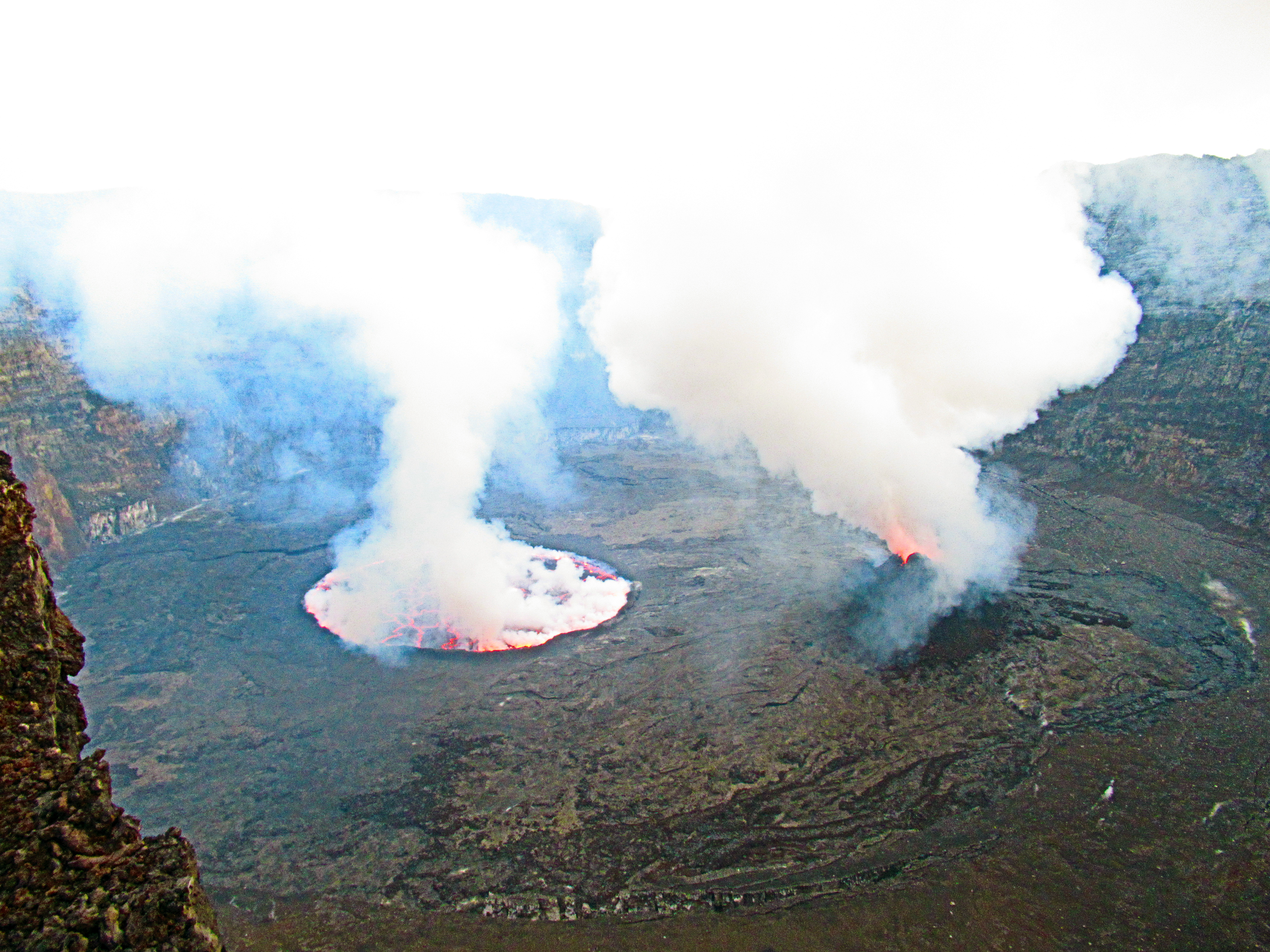
“Webcam image of Nyiragongo in February 2020 showing an open lava lake surface and incandescence from the active crater cone within the 1.2 km-wide summit crater visible during the day, accompanied by white gas-and-steam emissions. Courtesy of OVG (Rapport OVG February 2020).” sad its not online
Good photos and graphics, looks like Nyiragongo haves a shallow storage ay 10 kilometers deep.
A small shallow resovair is belived to exist within the lower edifice. The lava is so sillica poor its completely amazing. The most sillica poor of Nephelinites you often find at the flank cones.
This was blocked by the system for having too many links, and thrown in the dungeons. Released on admin orders, but please limit links to no more than 2 if possible.
Small fountains and tectonics play across Nyiragongos lava lake, numerous crustal over turns and small dome fountains and isolated bubble bursts. This coud have something with very low viscosity to do. But Halemaumau was also insanely low in viscosity, the degassing manner of Nyiragongo maybe diffrent, with no surface gas foam under the crust.
Here the Nyiragongo fountains also look rather warm and yellow. Nyiragongo is unlike any other lava lake thats active for now : ) And the only Nephelinitc one.
Photos wont pop up here sadely….
https://imgur.com/a/DtXYrH3
🙂
https://imgur.com/a/Pvm5hNi
We are in business now 😀
https://imgur.com/a/Oc5EvDq
Well the lake is gone…
https://fb.watch/2w6CkTRCoo/
livestream on facebook one of many 🙂
sorry all the posts
Kilauea is erupting!!!!!!!!!!! the groundwater lake is gone
Two fountains in Halemaumau now
https://hvo.wr.usgs.gov/cams/panorama.php?cam=KWcam
Halemaumau is lava fountains now
Another livestream:
https://www.facebook.com/K.BryanHI/videos/3905407856158940
It is just something to note that the entire 50 meter deep water lake is gone, in under an hour… It might not end up being a big eruption in the end, if its over in the morning that wouldnt be surprising at all, but it definitely has a serious eruption rate. That crater is enormous so the fountains could easily be over 100 meters high and they would still look small 🙂
It is just lucky the vent wasnt actually at the bottom of the lake but on the side of the crater so the lava just flows into the lake instead of fountaining into it.
New post is up. Eruption in progress
https://www.volcanocafe.org/the-kilauea-2020-eruption/
As an avid watcher of anime, indulger of conspiracy, and person who thinks extremely lowly of trends and people in generally. I hate this idea.
https://gizmodo.com/your-credit-score-should-be-based-on-your-web-history-1845912592
Increased seismicity near the Cerro Hudson volcano. https://watchers.news/2020/12/23/cerro-hudson-volcano-chile-alert-level-raised-december-2020/
Looks like Hawaii’s Volcano Rangers have had to cite a bunch of unwary sight-seers for wanting to gawp at their new lava lake. Only needed a *modest* shift in wind direction to severely gas dozens…
{ Business opportunity ? Armoured, all-terrain ‘bus’ service with own air-supply + air-lock ? Perhaps hybrid, so could safely trundle away downhill through toxic vog that would choke IC engines’ air-filter, lubrication etc ?? }
Somewhat tangential: Given Iceland’s hot-spot / plume now seems to have begun in Siberia during the Permian, then gone walk-about across Arctic & NE Canada, then SE across Greenland…
Could passage across Baffin Bay have derailed the Atlantic rifting, leaving part-opened Labrador Sea as the aulacogen, then stimulating the Eastern arm of triple junction ? Synergising its rift spreading to produce Iceland ??
Twofer of ‘plume’ plus ‘ordinary rifting’ may also account for some of the bizarre local chemistry variations…
As ‘plume’ still seems to migrating Eastwards –How fast ??– must wonder about Iceland’s future. Bereft of plume’s up-lift, will Atlantic rifting suffice to maintain it ? Or will island subside like the older end of Hawaiian chain ? Become a cluster of ‘high’ islands like the Azores, Canaries and Galapagos ??
Be really weird if Atlantic Ocean becomes warm enough for ‘Pacific’ coral reefs to flourish at ~ 65ºN. Of course, by then sea-levels may be 50~~100+ metres higher, given melt plus Antarctica’s isostatic rebound…
Question – is it actually migrating eastward?
Have to say I was behind the Iceland plume = Siberian traps but my opinion is changing.
http://www.mantleplumes.org/Iceland4.html
Your armored vehicle is basically a Cybertruck, just with some paint or something else to protect the stainless steel from the acidic environment, where it is not so stainless… Fully electric so it wont be effected by the atmosphere either.
Electric vehicle company that makes cars that dont need air, founded by same person who is going to Mars where there is no oxygen… 🙂
I think the Siberian Traps are way too old to be associated with an existing hotspot, and a lot of new discoveries are casting doubt on a lot of proposed plumes being real. Iceland was probably created about 55 million years ago when the north Atlantic opened.
I’d still suggest a hybrid, with IC engine for the up-hill leg, and electric down-hill…
‘Belt & Braces’ contingency thinking…
Also, IC fuel tank may be re-filled in a couple of minutes, like-wise an air-filter change. Not ideal, clogging filter will impair performance and acid gas will contaminate engine. But, any significant eruption, perhaps accompanied by quakes, may disrupt power grid required to fast-recharge the battery pack…
I’ll not dispute Iceland’s age, which is where and when the East-bound hot-spot met mid-Atlantic rift, ‘Went Large’. But there is so a volcanic back-trail across Greenland via North end of Labrador Sea, via Canadian High Arctic. Seems to extend clear across ‘roof of world’ to Siberia and Trapp Country…
With all due respect electric vehicles are already far better than combustion engine vehicles in all areas except flight and the niche cases of cross continental ground transport. Refueling time is not important and never was except for peopel who want to divide opinions, you dont need to charge for an hour to drive 5 km.
As for torque (which is what I assume you refer to in the ‘up hill’ bit) combustion engines are not even worth considering, electric motors are much more powerful, they have been the motor of choice for all high load heavy vehicles for the best part of a century.
I have a keen interest in this field, im not just a volcano guy 🙂
On Iceland, the important bit is if Siberia was in the location of Iceland now 250 million years ago. If it wasnt then there is no trail even if it looks good in theory. I have seen a plausible reconstruction that places Hawaii as the source of the Traps, you cant get much of a difference than that. It is still in my best guess likely the Siberian Traps happened from a source that is now gone.
Looks like they may have finally found the source of the Australasian tektite strewnfield. The Bolavan volcanic plateau in Laos was said to be the location – but it would have meant an impact directly onto a volcanic center that had already been erupting for 14MY and the crater to be frank looks too small.
The new proposed location is the Spratlies archipelago – have to say that the gravity anomaly map doesn’t entirely fit this area well. https://www.researchgate.net/publication/322502909_Spratlies_Archipelago_as_the_Australasian_Tektite_Impact_Crater_Details_of_Formation_Richard_Muller's_Dust_Cloud_Explanation_for_the_Mid-Pleistocene_Ice_Age_Cycle_Transition
What’s also interesting is that this is antipodal to the Altiplano.
Given fraught regional politics, may take a while to negotiate drill-rig access…
If you fancy making a epoxy volcano
https://youtu.be/ScGIhoji2EU
Just played Flight Simulator 2020… the biggest game world there is.. basicaly entire earth recreated in 3D in minute detail.. down to 3D grass. This is an INCREDIBLE game..playing at near highest settings..
The light and atmosphere and clouds and sunlight and sunsets are beyond awe! Its incredible what miscrosoft have managed to put togther. I just took off from Stockholm in the gathering pink evening winter glow and earths shadow and pink live weather 3D voluemetric clouds. Set on unlimited fuel Im flying down to Kergulen Islands. Live airtraffic and online players are also on. Im over Russia now in the near night at 30 000 feet. The computer will be running…
Flying into live tropical Hurricanes are popluar in MFS2020
MFS2020 beats google earth by a 1000 times… million times
Its also in constant progress of improvment… updating all the time…
Iceland is specialy recommended to fly over .. but you needs a very powerful computer to run it on higher settings
The smaller private jets go up to almost 50 000 feet… did that over Grimsvötn yesterday.. getting to watch the Indigo blackness of space and the blue haze in horizon… Holuhraun lava field can also be found in MFS2020. This is an awsome game.. and its a work in progress that gets better all the time updating satelites and techs and graphics. But you still need a powerful computer to get the most magic.
Still it looks very good on lower settings..
Hekla looks amazing in this game..and will be updated quite soon..( Great north europe area update ) ligths and textures as well as lava flow lobes are nicely rendered. Its also in true size..
Westfjords are another great scenery to fly low over.
How real ? Are Eastern Ukraine, Southern Iran and North Korea geo-fenced no-fly zones ??
😉
You dont get shoot down
But flying inte Real Live 3D hurricanes and typhoons in this game world.. is amazing! I flyed through many autumn 2020 Atlantic storms the sunsets and 3D CGI cumulus are totaly rad! Rendered from real satelite data and game engine.. its beyond amazing
Here is example https://m.youtube.com/watch?v=nZspfotpzq0
https://www.youtube.com/watch?v=QY9xhkidxAg
These graphics are totaly rad…
Yes incredible MFS2020 is
The gigantic scale of Hawaiis deep sea volcanoes
Yes, the Hawaiian islands are more like a small flood basalt province in scale, just with normal sized eruptions. The big island is at least 50% greater in volume than the Columbia river basalts.
One does have to wonder what would happen if Hawaii was on a much slower moving plate, or under a continent. The closest we have to that is at Afar, but even that isnt as productive as Hawaii, so its hard to tell. Current data indicates the output of the Hawaii hotspot is over 1 km3 a decade, and all of it is currently focused into that one vent in the crater of Kilauea, it boggles the mind… supposedly back about half a million years ago at about the time Mauna Loa was born, all 3 of the older volcanoes were simultaneously in their shield stage and Hualalai and Kohala were both once as big as Mauna Loa is today 🙂
I’am not even sure there is a hotspot at Afar anymore, it should have been carried away from it due to plate motion, but there is no track of volcanoes that matches, there is no unusual group of overproductive volcanoes anywhere in Ethiopia either (something like Vatnajökull). Erta Ale’s volcanism is similar to Alayta or other volcanoes in the Afar Stratoid Serties when they were at their peak.
It’s funny that the prominence of Kilauea is just 18 meters when the volcano has thousands of cubic kilometres and rises several kilometres from its base. At times, like during the Pahala Ash, lava flows from Mauna Loa must have been cascading into the cauldron of Kilauea.
Nice picture btw.