
Welcome to the Volcano Café bar, a place for all things on or off topic and inane ramblings. There has been a need of late to find a place better suited to various theories, long comments and enthusiasm. This page will be less moderated than the main article pages and cleared out every month (this may change depending on use).
Have fun and don’t forget to tip the barman 😉
Here is an image of Raikoke, from May 26 2019. This was a month before it erupted
This is a day after the eruption on June 23. (The explosion that caused the colourful sunsets around the northern hemisphere was on June 22)
And the after life. This is on 13 July
It looks the crater barely changed…
My feeling too. I was surprised. The island, on the other hand, was pretty much devastated.
Speaking of eruptions and aftermath-here is a computer simulation of the destruction of Pompeii:
Wicked. 😎
Scary!!
And on a more VC Bar like note…
https://youtu.be/hDNugQxZVbU
Too bad they didn’t have cameo by say, David Tennant carrying his screwdriver thingy…
Exter..min..atzzzzt.
Agree…. and the BBC folks could have easily goaded him into doing it for shits and grins.
Good PR is good PR.
Failing that, another Dr might have made a good stand-in.
Dr. Clive Oppenheimer – Volcanologist extraordinaire.
I’ve had my suspicions about Oppenhimer-anyone see a blue lLondon Police Box when he’s around..
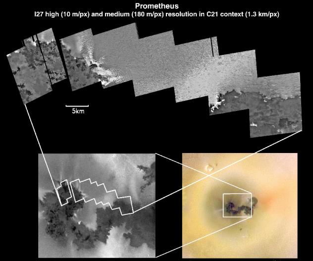
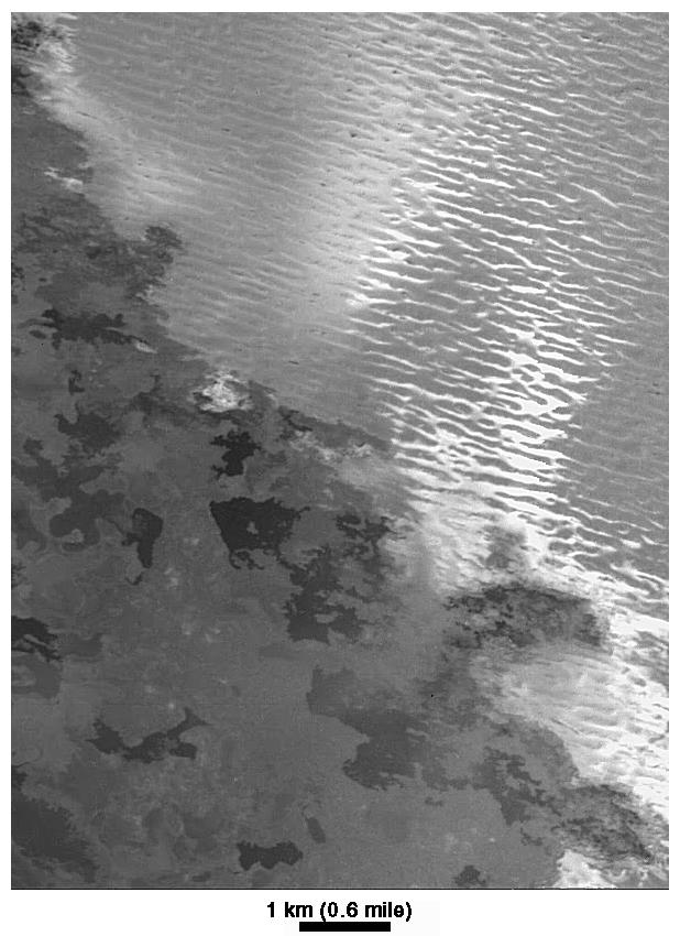
This is from one of the Raikoke images, 30 June 2019, and is the sea (ice?) just southwest of of Kamchatka.
Interesting eddies and current patterns…
Very. I wasn’t sure whether this was ice flows or fog, except that clearly the layer is very thin.
Albert
Ponta Do Pico in Azores and Pico island itself appears to be only 25 000 years old!
And all of Picos stratocone apparently began to form 6000 years ago.
The island is 50 km long and avarge 1 km above sealevel and is quite mountainous with Picos stratocone taking up most of the western part.
Thats very productive, more productive than I ever imagined.
Pico is a basaltic straovolcano built completely of very slow pahoehoe effusive activty from a summit vent.
Pico was prodbaly active slowly constantly for 1000 s of years before
Must have been the stromboli-kilauea of the atlantic eons ago.. always glowing.
Azores is a weak “dying” hotspot thats interacting with leaky faults in the seafloor in Azores tripple junction.
But its been more prodctive than I can ever imagine
This ‘weak’ hot spot (perhaps residual heat from the formation of the Atlantic) actually erupts on average every 20 years. It is almost ‘overdue’.
Since only Pico have dont constant holocene activity in Azores, slow fluid alkaline pahoehoe ( slower than Kilauea ) I suspect its near Pico and Faial.. where the dying Azores plume is situated.
Azores is a dying plume thats interacting with leaky tectonic faults in the seafloor
Near Azores tripple junction. Tahts why the islands are on these faults
Some of the more eastern Azores Islands are fuled by decompression melting in the Azores – gibraltar transform fault.
São Miguel is on souch faultline and recives very small ammounts of magma
Most magmas in Azores are alkaline to very alkaline
Signs of small ammounts of partial melting in the mantle.
São Miguel have lots of evolved alkaline magmas souch as Trachytes and Phonolites from diffrentitating alkaline basalt or basanitic magmas.
São Miguel is supprisingly large and active for being magma starved and its amazing it exist at all…
Temperaturewise Azores haves the best weather in the world.
Oceanic Subtropical
Its always supermild and very comfortable
winter 16 to 20 and summer 20 to 24.
Only Azores, Madeira and Northen New Zeeland have that climate.
Latitude 30 s over the open ocean.
Great if you are sensitive to both heat and cold
Don’t they get a fair number of underwater events, with hull-thumping and pumice rafts ?
IIRC, sailing ships often reported they thought they’d struck reefs / whales etc. And, IIRC, the infamous ‘Marie Celeste’ abandonment may have taken place in that area, with other ships reporting lesser incidents around that time: Getting the full treatment, your hull severely ‘kicked’ when your cargo was weepy barrels of flammable solvent, would have been the last straw…
Some new activity from the baby southeast of Barda. Magma movements???
I was going to say the same.
Vatnajokull seems to be getting noisy. Is something stirring ?
I noticed this paper out on tectonic plate movement https://advances.sciencemag.org/content/5/10/eaax4295.
Interesting research on do the plates cause movement, or the mantle? Seems like two-thirds vs one third.
Hope it interests people!
Worth the read not yer average dry scientific paper….
Have not finished it yet. Lot to unpack..
New post is up! But the bar remains open.
http://www.volcanocafe.org/magmatic-intrusion-at-greip
AVO:
SHISHALDIN VOLCANO (VNUM #311360)
54°45’19” N 163°58’16” W, Summit Elevation 9373 ft (2857 m)
Current Volcano Alert Level: WATCH
Current Aviation Color Code: ORANGE
A low-level eruption continues at Shishaldin. Lava is overflowing the summit crater and the lava flow on the northwest flank has increased in length. Satellite data on Sunday afternoon show that the flow has developed two branches, each extending for about 1000 meters (0.62 miles). Seismicity has decreased over the past 12 hours after an extended period of elevated high-amplitude tremor that was likely related to increased lava effusion. Volcanic debris flows (lahars) have also increased in length and now extend as far as 2 km (1.2 miles) on the north and south flanks. Sporadic incandescence was observed in overnight webcam images and satellite data show deposits of hot lava spatter on the summit cone due to minor explosive activity and/or lava fountaining. Small explosions have also been observed on local seismic stations and detected in regional infrasound data. No significant ash emissions observed in satellite or web camera data, although there are likely periods of minor ash emissions in the immediate vicinity of the summit crater.
Two seismic events in Hawaii that are probably not relevant but are quite amazing to see:
A brief but intense swarm of microearthquakes recorded at the summit of Kilauea:
I have noticed at least three of these during the two past weeks, the previous 2 were very shallow (sea level), this one reminds me of the big 10 km deep swarms that took place in previous months, since this one was small and short HVO hasn’t located any of the quakes in the monitoring map so I can’t tell exactly.
Rockfalls at Pu’u’o’o:
After the rapid swelling of Pu’u’o’o I have started paying more atention to what happens there and I have noticed that the tilt at POC (on the crater rim) jumped up from time to time on what I assumed to be pieces of the wall coming down, which must have been happening frequently since the collapse in April 2018. Today another small jump shows up and that is how it looks like. The earthquakes that have a gradual onset and sometimes look like a bell curve are the rockfalls and they cluster towards the event at 6:15 that must have caused the jump in tilt
Do we know what the weather is like?
There has been more activity in recent hours, but it seems to have been on the slopes of Mauna Loa an hour before Kilauea registered it. That sounds more like weather.
The only weather phenomena I have seen to show in the seismograms are rain showers, they look like volcanic tremor would but you can see how it moves from one station to another so that it shows up at diferent times in the diferent stations and with varying shape.
More often than weather I see that there is a lot of human noise, this is also usually local to one station and often occurs at certain hours of the day. It is worse in some seismometers than others, for example the one in Leilani shows continuous noise throughout the morning (Hawaii time).
The 2 images I posted come from seismometers that usually don’t show much noise, NPOC and SBL. I think it is volcanic because it is recorded identical in all summit stations plus it is very similar to previous swarms which clearly came from the conduit of Kilauea. Earthquakes like these are very frequent at volcanoes and it is called drumbeat, there is a youtuber, Ben Ferraiuolo, who posted a video about this and comparing them to those observed in Mount Saint Helens and they are practically identical, I am not sure if it is the same as “poppers”, to my understanding these have to change from high frequency to low frequency, I did have a detailed look at the frequencies of the first drumbeat back in early September but right now I don’t remember if they had this characteristic or not.
This would be anthropogenic seismicty:
The station is next to Waimea and Highway 19 so no wonder there is this much noise.
That is a very nice example.
As the originator of the “popper” term, there is no definite definition that I have made as to their frequency composition. My only real criteria is that they are very short tornilla style wave forms. Tornilla according to the references I’ve seen, state that they are several seconds in duration and show a harmonic component.
If your observations support the High to Low frequency transition, I’m okay with that. It would fit the generation mechanism as I envision it. (rock fractures, fluid flows in)
For fun
https://www.reddit.com/r/dataisbeautiful/comments/drhfwj/relative_rotation_rates_and_axial_tilts_of_the/
Yup! That was fun! Best!motsfo
https://www.dailymail.co.uk/news/article-7659183/Elderly-man-dies-fatally-falling-22FT-lava-tube-Hawaii-property.html
HVO has addressed the inflation of Pu’u’o’o in their last Kilauea monthly update:
“There was an inflationary event near Pu’u O’o that occurred during the end of September through the first week of October. Continuous stations near the cone, like OKIT, NPOC and KAMO along with KALR, a campaign station experienced an acceleration of motion consistent with source inflation on the rift between Puʻu ʻŌʻō and Kupaianaha”
So not right underneath Pu’u’o’o but to the northeast of it. The way deformation changed suddenly from one day to another makes me think it must have been an intrusion, sill or dike, a dike should have been noisier and way more short-lasting so I’m thinking a sill as the probable source.
I thought this interesting as well
Meanwhile at Mauna Loa. A couple of 3s subject to manual adjustment
3.0 26km ESE of Honaunau-Napoopoo, Hawaii 2019-11-09 13:34:28 (UTC) -1.5 km
3.0 24km E of Honaunau-Napoopoo, Hawaii 2019-11-09 11:39:24 (UTC) -1.5 km
They look big in the seismometers so likely to be around that size there has also been a 2.9 southeast of the M3s, 8 km deep along the basal fault (between the Kaoiki and Hilea Seismic Zones):
2019-11-09 13:34:34 M 2.9 8.4 km
If the automatic detection is right then the second 3.0 was followed six seconds later by
2.9 13km N of Pahala, Hawaii 2019-11-09 13:34:34 (UTC) 8.4 km
Within seconds, those tend to confuse the automatic detection system as recently seen with Pahala.
Reviewed already, it was faster than usual. The M3s downgraded to 2.7s and the 2.9 no longer exists.
Tiltmeters do not show anything unusual.
Two larger quakes near Mauna Loa summit. Some reverberation in the seismograph signals afterwards.
New post is up! Volcanic poison.
https://www.volcanocafe.org/mercurious/
Albert here is a funny question
Its something that no one wants to happen ..
But many certainly thinks about it
If Earth was placed inside the suns photosphere,
How long woud it take for our poor planet to be vaporized and turned into plasma?
It woud be like placing a little hard chocolate ball in a pot of boiling water…
40 years
But what about if we place Earth in suns core?
There temperatures and pressures are very much higher.
Are we talking about months now for Earth to vaporize? This is an insane question from a person that thinks too much
Also earths heavy element composition ( Earth is star ashes .. will be disliked by the solar core )
What woud happen?
The Mauna Loa swarm is continuing. The GPS north of the summit ridge (PHAN) has started moving south, since september – that is opposite to what it is normally doing. Inflation at the summit should make it move north, so I am not sure what to make of that. Perhaps the southwest rift is deflating.
I think there is also a clue with the MOKP-MLSP cross caldera graph that changed in August, then we lost the signal during this time frame. It then returned to its increasing trend. PAT2 also slowed its east velocity in the same time frame.
7 days all magnitudes
That’s what I get for leaving Mauna Kea off the map 🙂
Askja is shaking!
Kea is rocking
2019-11-11 17:11:23 2 35
2019-11-11 17:08:47 2.4 28.8
2019-11-11 17:01:20 2 31.4
2019-11-11 16:56:11 1.9 29
2019-11-11 16:35:52 4.9 32.6
2019-11-11 16:33:05 2.6 28.9
2019-11-06 19:08:15 1.7 19.4
https://www.solarham.net/
I wish it was possible to surf the solar tsunamis…impressive
These are photospheric gas waves that can be many 10 s of kilometers tall..
I needs a liquid hydrogen cooled surfboard and to somehow not sink into the photospheres interior
Albert any suggestions to make my dream a reality?
This is impossible… nothing can get inside the photosphere
everything becomes plasma
With supercold liquid hydrogen cooling and extremely reflective materials
Its probaly possible to fly a spacecraft in the suns photosphere for a short while.
Exterior needs a foamy insulating extremely heat resistant materials at same time cooled with liquid hydrogen pumped in tubes.
Only way to get close to the sun
Here is one for Jesper
https://oxfordre.com/naturalhazardscience/naturalhazardscience/view/10.1093/acrefore/9780199389407.001.0001/acrefore-9780199389407-e-293
And a less gloomy evaluation
https://www.nature.com/articles/s41598-019-47540-7#Sec2
which hit the news this week as ‘chance of 1 in 14000 that we go extinct next year’ even though that is not what it says, and quite explicitly so. One ‘paper’ (not to be mentioned) even got Yellowstone in.
Hmm…
They look at dangers from space and also biological dangers but sadly they don’t combine the two and estimate the risk from space biology. Brain eating space lizards will have to remain a black swan 🙂
“To Serve Man, it’s… it’s a cookbook!”
Oh well, as nobody followed up and it’s a Friday night in the bar
Humans are indeed an adaptable and intelligent species and will in the future use her techolology and intelligence to surivive. If we dont destroy ourselves.
But …
Asteorid and comet impacts that ruins the food chain and destroys infrastructure and cause impact winters
Are probaly the biggest threat
IF Swift Tuttle hits Earth, then we are certainly exctinct
Human extinction is probaly a very unlikley event for nearest future.
At least in my lifetime
But a potential Swift Tuttle event is doom for us all…
Year 4000 it will pass insanely close to earth.
And future pushes by Jupiter may put it on collison course.
Astronomers calls it one of the most dangerous objects to humanity
Swift Tuttle is 30 kilometers across and goes at almost 60 kilometers a second!
That woud send up so much rock vapour and hot materials in our atmosphere that humans woud be overwhelmed and then you have a impact winter.. that dwarf the dinosaur one.
In my opinon
Large impact events, really large ones coud be the most dangerous threat to humans.
Thanks for the articles and they discusses all kinds of dangers to man
But Impact events are probaly the most dangerous ( but they haves to be very large too )
Extinction won’t happen in our life times. I am certain of that: it is true by definition.
Can’t argue with that. It’s a self supporting statement. 😀
And then in the far future ( 1 million years ) Earth is maybe up for a major comet bombardment. As K dwarf star Gliese 710 C pass very close for our solar system.
And disturbs the cometary ort cloud.
10 visible incomming comets every year will be the result… astronomers says.
This almost sounds like Late heavy bombardment density?
Maybe I missunderstands things too here
But 4000 AU is insanely close: not much farther out than Sedna farthest orbit.
And Sednas orbit may be disturbed by Gliese 710 C s march in the outer solar system.
Sednas very eliptical orbit maybe the result of previous stars incomming
You have asked this before and the answer hasn’t changed. No significant increase in rate of collisions.
That’s *much* closer than the 70ky BP pass by Scholz’ Star…
https://en.wikipedia.org/wiki/Scholz%27s_Star
Given there are no known mega-craters or mass extinctions of that age, seems its Oort objects missed us.(*) And our in-falling ‘stirred’ objects are not due for many millennia yet…
But what if some came early ?
This inspired me to write ‘Hunter’s Night’…
https://www.deviantart.com/nik-2213/art/Hunter-s-Night-523385646
😉
—-
*) Extrapolating what Shoemaker-Levy did to Jupiter, could the ‘Great Red Spot’ mark a ‘Scholz’ Oort Splat’ ??
No idea, but Jupiter is pretty significant pertubator for infalling objects.
According to that premier scientific journal, the Daily Mail, on the basis of an Oxforn University study, you have a higher risk of dying as a result of human extinction in any given year than due to shark attack or lightning strike. Doncha just love creative statistics?
https://www.dailymail.co.uk/sciencetech/article-7673963/Humans-1-14-000-chances-going-extinct-year-getting-struck-lightning.html
Truly a magnificent landmark.
And now for something completely different: Earthquakes and the Ionosphere.
I vaguely remember having read something similar (but much less detailed) a long time ago.
Maybe something for a statistician to (dis-)prove?
https://hackaday.com/2019/11/12/hf-propagation-and-earthquakes/
This was found in the spam folder. Not sure why but it may have been thrown there for doubts about the email address that was provided. As a general comment, if there are concerns about providing an email address when signing up: our policy regarding its use can be found here: https://www.volcanocafe.org/volcanocafe-and-the-gdpr/
– admin
I have come across this before. It is a bit baffling and different papers on it are not in great agreement. The main problem with it is how the subsurface rock communicated with the ionosphere. There is no plausible mechanism. So I would like to see a double-blind experiment where such ionospheric disturbances are studied independent of any known earthquake, to see whether they can pick out these earthquakes. I have not seen a study where that is done.
IIRC, the biggest WW2 bombing raids’ shock waves caused recorded disturbances of the ionosphere…
Aha !!
https://phys.org/news/2018-09-impact-wwii-raids-felt-edge.html
https://www.ann-geophys.net/36/1243/2018/
{{ Open Access to full PDF etc !!!!! }}
More fun with planets
https://youtu.be/usYC_Z36rHw
https://m.youtube.com/watch?v=oBDZtt0vWD8
Another really fun one! and luckly impossible
Not possible, I’m afraid. That is within the Roche limit, and so the moon would fall apart. It would be pulled to bits (very small bits) by the Earth’s tides. The closest orbit it can have is some 10,000 km high, not 400 km. About the distance of the GPS satellites.
Seen across south Hawaii
The smaller hickup starting at 16:30 is probably the M7 from Indonesia. The rest is local.
It was 2 spasmodic tremors from Pahala.
The first big one: 2019-11-14 17:15:24 M2.7 40.9km
And the weaker follow-up: 2019-11-14 18:15:08 M2.3 35.6km
I am very intrigued with Pahala, the tremors that originate from the southern part of the swarm peaked back in March and have been much less frequent over the last few months. However the rates of earthquakes from the northern part of the swarm skyrocketed in late August and have remained fluctuating but far above normal levels since then, it will be interesting to see how this evolves over time.
Hi Albert I haves a question about sunspots on Ultra-cool .. ultra dim Red Dwarf stars
Like TRAPPIST-1 haves a photosphere temperature of only 2500 C
The sunspots on that star woud only be
1400 C ? In these ultra cold sunspots
woud the heaiver elements in the star condense into glowing hot clouds?
woud the ultracool sunspots on TRAPPIST – 1 have sillicate droplet lava clouds ?
that rains molten rock into the stars hydrogen interior?
Brown dwarfs up little above 2000 C
Do have sillicate and iron clouds and hell – rain
But what about the sunspots of the very coolest red dwarfs?
https://www.researchgate.net/figure/Schematic-of-cloud-layers-in-atmospheres-ranging-from-Jupiter-to-the-warmest-brown_fig2_2400918
https://mobile.twitter.com/newscientist/status/530011697000370178/photo/1
If the Sunspots on these smallest Red Dwarfs
are below Iron and Sillicate vaporization temperatures
It coud condense to ”hell clouds” in these sunspots.
But it also depends how rich the star is in heavy elements.
Our own sun is too massive and too hot for souch rains
And most Red Dwarfs are certainly too
Albert any opions of the conditions in the sunspots on Ultra – cool red dwarfs?
If the TRAPPISt – 1 photosphere is only 2500 K ( 2500 C )
What about the cool sunspots on these ultra – cold Red Dwarfs?
Sillicate rain and Iron rain from clouds seems even possible at normal photosphere on souch a cool Red Dwarf.
But its the sunspots on these coolest Red Dwarfs Im curious on.
How hot are they? and does they have heavy element condensation and rains?
Iron melts at 1538 °C and turns into a gas at 2862 °C
TRAPPIST-1 haves 2500 C in normal photosphere!
This red dwarf coud absoutley have glowing hot iron clouds and sillicate clouds and their rains. Even outside the coolest sunspots
If the star is rich enough in heavy elements
Red glowing orange clouds and thunderstorms!
Thats what you woud see in TRAPPIST – 1 upper layers
Glowing mean hell sillicate cumululonimbus
Raining lava and molten metals into the stars interior where it evaporate and rise up and condense again..
Ultracool stars may not have star spots. Mid-range M-type stars do, and their spots are about 200 K cooler than the photosphere. The highest temperature where particles can form is around 1600 K where some oxides become stable. Silicate requires 800 K and iron even lower. These temperatures differ from those needed on Earth because of the low pressure in stellar atmospheres. Amorphous particles cannot survive in these conditions. Some crystaline particles may be present further out: these are transparent so don’t get hot.
I means liquid droplets not solid crystals
TRAPPIST-1 is cool enough for Iron Rain in the photosphere
Thanks for your opinion.
But many cool small Red Dwarfs are insanely magenticaly active
No liquid. There is no liquid phase in near-vacuum. You only get liquids under higher pressure. And magnetic fields are strong in mid-range M stars, but the coolest ones are much less magnetically active.
Red dwarfs haves extreme surface photosphere density
being small compact stars…
But highest mass brown dwarfs are probaly even more dense at upper atmosphere as they are not puffed up as red dwarfs are.
And liquid rock flows on IO s surface in vaccum
Lava can flow in vaccum right? it does that on IO
Pressure in the solar photosphere is less than 1mb. The solar atmosphere is a lot lower still. It is a near vacuum.
But molten rock can be liquid in a vaccum right?
Mars and specialy IO haves / had active lava flows in very low pressures.
Ionian lavas flow in vaccum
No. They will almost immediately either boil or freeze (or both) at the surface. Liquid lava on an airless planet is only possible underneath the surface
A red Dawrfs solar photosphere is much much denser than our larger suns.
Our own sun is hotter and more puffed up and less dense in photosphere.
A red Dwarf is compact and cool and haves a very high “surface” gravity
And is denser in photosphere.
Im correct here?
The difference in surface gravity is only a factor of up to 5. It makes no difference on this scale. Sorry, no rain on the sun.
Lava sourely flows free on IO s surface!
Many Inoian flows are pahoehoe or Aa and displays same morphology as earthly hawaiian flows
We haven’t had a riddle for a while.. can anyone guess which volcano this is? The image was taken four weeks ago.
This is just west of Theistareykjarbunga
Half a ding. Does it have a name?
Teistareykir?
Nope to myself. That seems to be just a synonym of Theistareykjarbunga. After some extensive search I think I found it: Bæjarfjall
Ding. Well found. Of course, this being Iceland, it is not the only place with this name. You wouldn’t put it into your satnav
Albert
😉
Gesundheit…
/
Bærjarfjall
For unfathomable reasons this was classified as spam by our deamon. We apologize for this. Among the VC faithful, the spam dungeon is well known for its ready supply of cookies, needed for the long wait. – admin
You were right, and you were the first, so ding has been taken away from its current owner and given to you.
This volcanic feature Bærjarfjall bears a small-scale resemblance to the many pancake-shaped lava domes found on the surface of Venus. But only the origin of Bærjarfjall was different of course – it was looks to me like it was formed subglacially under the pressure of the thick ice cap covering most, if not all, of Iceland during the last ice age. A lot like the immensely dense Venusian atmosphere preventing any explosive eruptions, instead forcing the silicic lava to ooze out into a voluminous flat mass. Then, like the Venusian “pancake domes”, the central crater was probably formed in the end due to the magma conduit draining afterwards.
There is apparently another one of those volcanic feature about 10 km to the SSE, right next to the Krafla fissures which erupted from 1975 to 1984. It’s a bit harder to make out from Google maps satellite view, as it has more irregular edges. But it appears to be flat-topped and has a central crater like Bærjarfjall.
This is the larger area with your peak (Sentinel image). Note the lava flows, clearly visible because of their lack of snow.
and the next one is further to the south
Winters there are miserable
Extremely stormy and very humid
And a cold heavy maritime subpolar cold.
Iceland is one of these places with worst climate in the world
The dark Aa lava lobe is from 1975 – 1984 Krafla lavas
This from Júlía Úlfdís Jóhannsson 2009, Master thesis:
“The Ice Age glacier retreated from Þeistareykir well
before the end of the Ice Age. At that time the area became mostly covered in lava. The
lava fields in the Þeistareykir area are from the end of the Ice Age, or 10,000 to 14,000
years old, except for Þeistareykjahraun, which is the most recent lava at around 2500 years
old. All lavas are from shield volcanoes, of variable size and with petrological differences.
The geology of the area is dominated by basaltic lava, hyaloclastite and intrusives.
Lambafjöll and Þeistareykir mountains consist of hyaloclastite, palagonite and pillow lava.
Bæjarfjall and Kvíhólafjöll are hyaloclastite (tuff) mountains created in a subglacial
eruption during the latest (glacier) stage of the Ice Age. North of Baejarfjall is Ketilfjall
that is a tuff ridge from the second to last glacier phase of the Ice Age. “
Regarding the Pahala quakes, the overlay shows where they are. This is an almost flat area at at some 700 ft altitude. Ideal for a sil: because the surface is so flat, there is very little net force pushing the magma sideways. The quakes avoid the steeper country on the other side of the road, and avoid off-coast, both much steeper. I think this is indeed a pool where new magma collects. Eventually it will go to either Kilauea or Mauna Loa (or both) but that could be a long time. The continuous quakes show that the magma is not flowing through: it is piling up.
Albert
I think we need to ask HVO to enlarge their Deformation page (Earthquake Hypocenters Map and Cross Section) west to longitude 155.5 so that we can see them there. I am sure that there would be issues, science, automatic reporting, and money issues that may prevent this.
I spent enough money over there in our 3 summers visiting, yeah maybe not!
Mac.
An interesting article has popped up regarding porosity of lava domes, and explosivity of volcanoes like Merapi. Apparently domes can get sealed by volcanic gasses.
https://www.nature.com/articles/s41467-019-13102-8
Thanks. Interesting and scaring!
[youtube https://www.youtube.com/watch?v=xFrGuyw1V8s&w=543&h=407%5D
As our attention was diverted by Askja and now Reykjanes ridge, Greip managed to sneak in another deep swarm. DJK drumplot is not functional at the moment, but it was clearly visible on KIS and DYN.
Friday
15.11.2019 19:50:26 64.567 -17.186 20.1 km 0.7 99.0 18.2 km ESE of Bárðarbunga
Friday
15.11.2019 19:48:32 64.594 -17.178 17.6 km 0.7 99.0 17.5 km ESE of Bárðarbunga
Friday
15.11.2019 19:47:47 64.591 -17.177 18.7 km 0.7 99.0 17.6 km ESE of Bárðarbunga
Friday
15.11.2019 19:46:52 64.590 -17.247 24.7 km 0.7 99.0 14.5 km ESE of Bárðarbunga
Friday
15.11.2019 19:45:15 64.590 -17.164 20.5 km 1.5 99.0 18.2 km ESE of Bárðarbunga
Friday
15.11.2019 19:44:40 64.590 -17.164 19.6 km 1.8 99.0 18.2 km ESE of Bárðarbunga
Friday
15.11.2019 19:43:59 64.593 -17.177 18.7 km 0.8 99.0 17.5 km ESE of Bárðarbunga
Friday
15.11.2019 19:42:14 64.592 -17.171 17.0 km 0.7 99.0 17.8 km ESE of Bárðarbunga
Tectonic only or some wet signatures??
Posted the page showing the activity below.
Can’t believe that this does not have some volcanic component..
The ‘YOUNGER DRYAS IMPACT THEORY’ gains traction with the discovery of airborne soot, and anomalously-high concentrations of palladium and platinum (of a possible extraterrestrial source), in sediment cores taken from a lake in South Carolina. The Younger Dryas was a sudden return to Ice Age climactic conditions about 12.8 thousand years ago, following a gradual warming after the Last Glacial Maximum (at about 20,000 years BP). This abrupt cold snap lasted 1,300 years, and has been tied to the mass extinction of ice-age megafauna, such as Mastodons, Mammoths, Saber-Toothed Cats, and many others. Previous explanations held that very large meltwater lakes in North America (Pleistocene Lake Agassiz), catastrophically drained into the North Atlantic, disrupting heat transfer into the region, and returning North America and Europe to glacial conditions. This impact hypothesis suggests that an asteroid or comet hit northwest Greenland (forming the Hiawatha Glacier Crater), melted the ice there, and had the same effect in the North Atlantic Ocean. It also suggests that more than one impactor was involved, with numerous ‘airburst’ impacts simultaneously around the globe, which also set fire to ice-age forests. The result was an ‘impact winter’, in which smoke and dust blocked the sun, and helped to abruptly lower temperatures around the world. Here is the study, published in the Journal of Nature: https://doi.org/10.1038/s41598-019-51552-8
This hypothesis remains very controversial. The ice cores show that the platinum came down over a 21-year period. Dust does not stay up that long. People proposed multiple impacts and that becomes very dubious.
How exoplanet
dayskies and evening skies coud be coloured
According to diffrent atmospheric pressures and
diffrent main sequence star luminosity intensities.
Planets with denser atmospheres than Earth
Develops pale creamy faint greenish Noon skies
And amazingly red fiery burning sunsets
Authur of the image comments:
”1 bar Earth-like atmosphere densities would tend to be light to dark blue at the zenith, due to the scattering of low-wavelength blue light. If the planet’s sun was very hot, the sky would look a deeper blue, while cooler stars would give the sky a lighter blue to almost white look. When the sun gets to 3000k and below, the sky starts to take on an orange/brown tinge.
Like on earth, the horizon is the lightest in color and the zenith the deepest.
10 bar Denser exoplanet atmospheres would appear brighter (more washed out) and the primary color in the spectrum more “pure” (I’m unsure what the term “pure” means exactly when it comes to optical perception…would it look whiter?). Likewise, thinner atmospheres would be less bright than earth’s and the colors more “pure.”
With increasing pressure the sky color at the zenith becomes increasingly yellow. In my image this means that an earth-like sky at 10x earth pressure would appear blueish/green near the zenith.
At lower temperatures I’m assuming the sun would appear tinged by the color listed under “star temperature.” Otherwise you’ll probably only see the star’s color when it’s near the horizon.
I’m assuming when you get down into K and M class suns, the surroundings on the planet would take on a progressively redder tinge due to the decreasing prevalence of blue wavelength light.
I suspect the gradient of color from horizon to zenith will be steeper/gentler in some atmospheres. I’ve guessed that the gradient would be more apparent on a high G world (on the right). ”
No doubt that habitable exoplanets with denser atmospheres than Earth…. that also orbits M Dwarfs
Experiences insanely red, insanely intense sunsets
Spectacular
Thank you.
Have grabbed as deep-background for tale idea that’s creeping towards ‘critical mass’.
Now need to find calculator for BIG exo-moons, figure the insolation, tidal stirring, day / month length etc etc for tau Ceti f:
https://en.wikipedia.org/wiki/Tau_Ceti
How big an exo-moon do you want? The year for this planet lasts 21 of our months. A big moon would probably be tidally locked, like Pluto and Charon, so assume a very long day and the moon will remain above the same point on the planet’s equator – and vice versa. No tidal stirring when it is already tidally locked. The way around it is an elliptical orbit, such as Mercury (and Io).
IIRC, due to Earth’s polar precession and Solar tide etc perturbation, our Moon has a just-enough elliptical orbit to have deep quakes (c/o Apollo Seismometers) while resulting libration provides ~ 59% coverage…
‘Erewhon’, my hypothetical mega-moon, would be about 2/3 Earth-mass, but ‘Mars+’ density with a smaller core than ours, so limited plate-tectonics. Volcanism is mostly tidal-stirred ‘hot-spots’ feeding a few, vast calderas, mostly buried in ice. Shallow-ish seas rather than oceans, currently ‘drawn down’ and mostly frozen. Face-locked, so ‘day’ is an orbit of host ‘Super-Earth / Water-world’, which I must calculate. That host planet has a modestly elliptical orbit, so there will be seasons, eclipses, night-shine etc…
==
Seems, two dozen million years or so ago, a passing ET had the bright idea of terraforming anaerobic tau Ceti ‘f’ and its then-warm, ‘mini-me’ moon with Terrestrial cyano-bacteria etc.Unfortunately, these did too good a job, totally trashed the CO2 & CH4 greenhouses and precipitated ‘snowballs’.
IIRC, this happened on Earth, in several cycles, but we’ve more distributed tectonic volcanism and deeper oceans, thanks to subduction and such…
Volcanism is slowly rebuilding Erewhon’s CO2 content. There are now two large, mostly-ice-free, geo-thermal ‘oases’ near the equator. Atmosphere is breathable, albeit Himalayan ‘Base Camp’ grade, wary acclimatisation required…
Another passing ET makes ‘First Contact’ in ~2024, parks at our L5. Trades standard replenishment asteroid gleaning fee and much Mozart, Bach etc for some theory & tech (there are rules), a gazetteer of the solar neighbourhood and a ferry ride to ‘Erewhon’ for 300 colonists in hibernation plus much materiel. There’ll be 50 in lead team, 250 to be woken six months later.
After the lead team are ‘chilled down’, Realpolitik considerations change the trade terms. More theory & tech is bought, while only that ‘lead team’ will go, along with a fraction of their materiel…
Even a failed colony will secure Earth’s future rights to entire tau Ceti system, cheap at the price…
Brrrrr…
==
FWIW, I’ve just found…
http://planetmaker.wthr.us/#
not much going on with me… just enjoying finding my glasses in the mornings. But for You people who don’t FB, here is a read i enjoy on Twitter and Commander Hadfield does too so it’s not just me… https://twitter.com/Rainmaker1973
You’re Welcome….
Best!motsfo
What is going on here?

Some comments about it in the earlier post beginning at https://www.volcanocafe.org/mercurious/#comment-42689
IMO have updated commentary
https://www.youtube.com/watch?v=68Ix3YIhmlI
Their volcano – addiction became their doom…
Still Maurice and Katia Kraffts films and images are now legendary…
During their lives they visited perhaps many 100 s volcanoes and got close to 150 eruptions
Hi Albert!
You say molten lava cannot flow in vaccum?
They can absolutley do that!
On the moon Impact melt from impacts been sprayed for 10 s of kilometers and flowed downhill.
And on IO lava flows free over the ground.
Many Ionian lava flows resemble the pahoehoe flows in Hawaii.
Here are examples of Ionian basaltic pahoehoe flows.
https://photojournal.jpl.nasa.gov/catalog/PIA02568
https://photojournal.jpl.nasa.gov/catalog/PIA02585
Sourely lava can flow free in a vaccum on IO?
Io has an atmosphere, although a little thin: the pressure is 5-40 nbar. Much of the surface has SO2 ice and this sublimates in sunlight and refreezes at night.
No liquid is stable in vacuum. But how quickly it evaporates or freezes varies with the material. I don’t know the speed for lava. You would expect a thin solid film to form over the lava.
IO s day is below – 100 C
SO2 ice is stable
The sulfur snow comes mostly from the lava lakes.. IO s basaltic lavas are rich in sulfur gas
When they bubbles out the basaltic melts
It freeze in the vaccum forming sulfur snow
It has been seen that the atmosphere almost completely freezes out at night and reforms in the day. So it comes from SO2 sublimation and not from volcanic activity. That was a bit of a surprise.
This is IO s Amirani lava flow! the largest basaltic lava flow in the solar system.
Feed by 300 kilometer long lava tubes!
Galileo measured hotspots of over 1300 C there.
The dark spots are fresh breakouts of lava flows over the surface.
The yearly basalt coverage of Amirani was 10 times larger than Holuhrauns!.
Hot lava absolutley flows free over IO s surface
Need some help with these events. They look like backward earthquakes. around 18:22 and 19:02 UTC. The one around 19:13 is weird also. Could it be they are working on them?
The two events after 9:30 are real earthquakes. The rest looks like traffic, indeed stopping at the site. The fact that it starts after 7:30am is also a hint.
After looking at this again……maybe a helicopter ride up, discharge staff and equipment (18:23-26 ride up), (3 min at idle discharging passengers) (18:29-34 fly away).
Come back 9:03-08 and land, pick everybody up, 19:12-17 take off and fly away?
Mac
perhaps. But I think this location can be reached by car: there are tracks visible on the satellite images. Helicopters are not ideal at high altitude and clouds can come in quickly here. I would prefer driving!
A caldera the size of the chixiclub crater…VEI 9 anyone?
https://technology.inquirer.net/91590/filipina-scientist-discovers-worlds-largest-caldera-in-philippine-rise
Look at the paper itself. The evidence is very thin. They have no real evidence that this is a crater, apart from a vaguely circular formation. Too deep for explosive activity but it may have been shallower 40 million years ago. It is classified as a mini LIP.
https://www.sciencedirect.com/science/article/pii/S0025322719300684
Facts are the ultimate bubble buster I guess…
More likely to be a Graben with a bit of associated lava being squeezed out, but for it being a caldera. My scepticism is currently gushing.
The reason why I am sceptical is that I briefly made the same mistake over at the Azores. Instead of a mindboggling caldera I ended up with a huge arsed Graben between a few volcanic islands that had sprouted up at the edges.
I am fairly certain we will end up with the same thing here.
Hey these signals are tornillos right?
 ‘
‘
I
Come on guys! It’s so lonely tracking a volcano all by one’s self!
A geophisicist from HVO discusses the seismic actvity of Kilauea and Mauna Loa through 2019 in Hawaii Tracker: https://www.youtube.com/watch?v=prpz3vN4du0&feature=youtu.be
They mention some interesting things and show a couple of nice plots.
HVO isn’t very sure on when will the next eruption of Mauna Loa occur, they expect the next eruption to start at the summit and probably without much warning but they are not worried because no one lives up there… Then it could move into one of the rifts or not (It usually takes several hours to several days for a dike to intrude from the summit to an eruption site downrift).
The Pahala swarm is really going at it right now, in the plot shown current rates of seismicity are the highest in 50 years! There is the problem of the network’s sensitivity so while smaller events have been filtered out it is probably only safe to say that these are the highest rates since 2011 when a big network upgrade took place. Seismic activity has more or less been increasing for the past 5 years and then last August it skyrocketed as those who have been following the situation will know.
They mention another intense Pahala swarm around 2005 which called my atention since around this time Kilauea got a mantle surge switching from deflation to inflation and culminating in the Father’s day intrusion/eruption and the opening of the TEB vent. It therefore could get interesting when the magma batch that has arrived to Pahala in late August starts moving towards Kilauea or Mauna Loa.
There is not much discussion about Kilauea itself but they do go into the south flank, it remains more active than before the 2018 eruption more than expected just from the aftershock sequence of the M 6.9. I think this is probably due to the stop of the Pu’u’o’o eruption, estimates indicate that the seaward movement of the south flank was about 10-20 cm/year when there was nothing releasing pressure and it slowed down to 8-5 cm/year with the Pu’u’o’o eruption. Currently the flank is creeping at about 12 cm/yr which results in a faster strain buildup and therefore increased seismic activity respect to 1983-2018 levels.
Here’s the screenshot of the Pahala 50 years and 5 years charts. This is adjusted to filter out quakes too small to have been detected by the earlier sensor network. The last major upgrade of the sensor network in the area was in 2011 and it was stated there isn’t any discontinuity at that point and this is thought to be an accurate representation of the last 50 years at Pahala
Sorry it’s not totally in focus but that’s from the source video.
This graphic shows possible path to Kilauea. Phillip Ong (local geologist) and Brian Shiro (USGS) discuss this further in the video.
Funny thing about the magma path, as the name indicates the Mantle Fault Zone is indeed a fault plane that generates large earthquakes from time to time, they follow a typical mainshock-aftershock sequence which would be supposedly tectonic and yet it is also thought to be the magma conduit of Kilauea. But having a fault and a magma body at the same time seems really weird, is it even compatible? an area where brittle failure earthquakes of up to M 6 are happening but also magma should be flowing through. If you draw a straight line from the Pahala swarm to 30 km swarms that occur under the caldera you go right through the mantle fault zone, I find it really confusing and hope for some event in the future that sheds some light over the conduit and how it works.
In this model the conduit is not directly under halemaumau either…
Worth noting that the tremor quakes on the figure from Welch and Thelen (2015) are the same as the “other events” located by HVO. After reading the publication it seems there is a reasonable explanation to these other events and how HVO manages to locate them.
A while ago Albert said that the events placed in the monitoring map couldn’t be from tremor but rather actual earthquakes because it would be very hard to locate it and I would repply that it had to be tremor because it coincided in time when it appeared in the seismometers and couldn’t be normal earthquakes or otherwise they wouldn’t have been tagged as other events.
So suming up from Welch and Thelen: the “other events” are indeed actual high-frequency earthquakes that originate at an average depth of 41km, remarkably the ones studied by Welch and Thelen (time interval: 2009-2014) are M 1-2 while this year we have had tremor quakes/other events of up to M3, in fact there was a 2.7 about week ago though they were much more frequent around March and have declined since then. In the seismometers they look like a series of spikes.
The earthquakes are embedded inside the tremors which Welch and Thelen locate to 60 km deep which is surprisingly far away, 20 km, from the tremor quakes, even when they are time-coincident. So I don’t know what to think about that.
Original paper on free access at https://agupubs.onlinelibrary.wiley.com/doi/full/10.1002/2015GL064869
Geophysical Research Letters
Research Letter Free Access
Linking magma transport structures at Kīlauea volcano
Aaron G. Wech
Weston A. Thelen
since this is the off – topic VC bar
But I think the cause for Alzheimers Disease may finaly have been found.
Here is some very strong clues.
Here is latest medical news
Its a product of years of infectious agents and the brains ways to defend itself.
Nearly all AD patients thats been tested in this study haves bacteria and bacterial enzymes in their brains.. very significantly higher than healthy diseased brains.
When a bacteria that called Porphyromonas gingivalis was allowed to infect Laboratory Rat mouths, the bacteria and most important the bacterias enzymes travelled to the brain by blood stream.
The test Rat subjects very quickly developed Classic Alzheimer Pathology as result of the bacterial infection. The bacteria also directly caused the buildup of classic Alzheimer protein plaques in the rat brains.
The same bacterial enzymes is present in the Brain plaques of nearly all AD patients, in the regions with the missfolded proteins
New research points to infective cause of Alzheimer and that the infective agents and the brains own defensive systems togther form Alzheimer pathology when bacteria gets into the blood brain barrier
If the brain’s response infection is too severe, it may lead to an over-accumulation of beta-amyloid. This could cause the formation of protein plaques involved in Alzheimer’s disease.
This New way of thinking is strong clues
But far from proof right?
https://advances.sciencemag.org/content/5/1/eaau3333
So ‘Classic Alz’ may be auto-immune ?? Would also explain the oft-cyclical nature of symptoms…
Suggests a vaccination may be possible…
Speaking of which, the Australians may have serendipitously found a link between children’s Rotavirus infection and subsequent Type_1 (‘Juvenile’) diabetes.
IIRC, their Rotavirus vaccination program has been running a decade, and the number of those kids subsequently developing Type_1 diabetes has dramatically fallen. Beyond all but most purblind statistical dispute…
That’s so gonna upset the Anti-Vaxxers, given ‘Type_1’ is one of the remaining ‘Dread Childhood Diseases’ for which no prevention seemed likely…
The tangential discovery that even a mild measles infection erases many existing immunities by zapping ‘cellular memory’ of prior exposure may mean such un-vaccinated kids face ‘double jeopardy’, along with the rest of their community…
I’m old enough to remember Iron Lungs Chicken pox so bad
that inside of the victim’s mouth had them. a family member was born blind because his mother had German measles-he
was autistic,too. The anti-vaxxers hurt their families with this crap.I had a girlfriend who was type one this will be (is ) a game changer.
For me thats been struggling with gum disease for my entire life, this is not welcoming news…
Putting my brain at risk…
Im unlucky: haves a geneticaly bad mouth flora.
I brush many times a day, and teeth are in good shape.
But the gums are constantly inflamed…
Its the very toxic gingipains from mouth bacteria, that causes Alzheimer patology when they have acess to the bloodstream during inflammation.
The study above is very very solid clues
Brushing does not reach infected gums. If you have that problem, a course of ‘deep cleaning’ may be better for you. The dentist should know.
As to a relation to alzheimers: this has been suspected for some time but is unlikely to be the only cause. Heart disease can also be related to gum disease – it is a goo idea to get it treated properly!
Done deep cleaning many times:
my teeth are in very good shape
Its just that my mild gingvitis is very presistant. Bad flora
The Kilimanjaro expedition is exciting too
Have you tried rinsing your mouth daily with an antiseptic mouthwash like Cepocol? That should keep the mouth flora and gum inflammation under control.
But what an exciting study!
The cause for Alzheimer have probaly been found.
The P. gingivalis, or gum disease bacteria, easily travels to the brain and builds there over time. In mice, this pathogen injures neurons, increases inflammation in the brain. The inflammation in turn causes dementia– and directly causes Alzheimer’s-like symptoms.
Bacterial P. gingivalis produces toxins called gingipains. In patients with Alzheimer’s, gingipain levels correlate with the amount of toxic tau and amyloid tangles within brain cells. Its found in all alzheimer attacked regions.
And in senile plaques
Another study found that inhibiting the gingipains in the brains of mice reduced neuroinflammation. Furthermore, it reduced the existing brain infection, and rescued neurons in the hippocampus.
Hey these are tremors right? If they are what are they indicative of?
They look very brief to me, I would recommend comparing at least 2 stations next to the swarm, if they do not coincide then chances are it is noise.
I don’t have good eyesight but i do think there is a faint copies.
The wavy signal at 03-04 that is the kind of thing you are looking for, something that is obviously identical in two stations. If ticks this then you are ruling out things like weather or traffic. It may still not be related to the volcano, that signal in particular looks unnaturally very very long period. Knowing where the stations are located might also be usefull.
Did a quick search and apparently the period is not as long as it can get in a volcanic earthquake, so it could be something or not related, idk. I myself am learning so maybe some day I can do some research into the diferent types of volcanic-related signals you can get and even do a guest post but when I have more free time.
Consider yourself invited!
Here are the monitoring stations, make of it you will.
I remember seeing signals like this while looking at the Big Island. I found several times that it is a far away quake that shows up on different equipment. Could be this one??? I do not know how to do the math on this to verify.
4.6
6km ENE of Ano Kastritsion, Greece
2019-11-26 04:49:32 (UTC)
35.0 km
.
Oh damn it! https://www.igepn.edu.ec/ccn-red-de-monitoreo
Here are the monitoring stations…
Did you mean M 6.4 – 12km WSW of Mamurras, Albania
2019-11-26 02:54:12 (UTC)?
I think that you are right, but no idea of how to verify it either.
I think if you looked at the longer plot for HHZ you might see several of those quakes in the area. There were two other quakes in the 5.0 range in between the 4.6 and the 6.4. They used to talk about how long it took the Kilauea “blasts” to reach the west coast instruments for verification. Maybe that would get a rounded idea of what time frame we would expect for the distance??
5.3
9km WNW of Vore, Albania
2019-11-26 03:03:00 (UTC)
10.0 km
5.1
6km NNW of Shijak, Albania
2019-11-26 02:59:24 (UTC)
10.0 km
Could also be traffic.
Shallow Kilauea summit swarms (~1-0 km deep) seem to have become episodic and coordinated with the DI events.
The swarm starts around 19:00 11-25 (Honolulu time) more than halfway up the inflation phase of a DI seemingly at the point where it reaches a level of pressure higher than before the DI started, the main swarm then continues until 2:00 when the inflation phase stops and then continues at a low level until 18:00 when the next DI event starts and the swarm stops. So it shows a perfect correlation with pressure.
It is also worth noting that around September the summit changed from ring fault swarms that were due to settling of the caldera to south caldera swarms driven by pressure increase. But the swarms are still small and I would say that the system is still relatively stable (or so it seems).
Here are the monitoring stations… right this time.
https://www.igepn.edu.ec/ccn-red-de-monitoreo
Happy Thanksgiving for those who celebrate it. I will be cooking for hours but love the day!
Some new activity in the area west and a little north of the Mauna Loa Caldera.
2019-11-28 11:00:04 1.9 -1.2
2019-11-28 08:52:30 2.5 -3.5
2019-11-28 08:34:32 2.6 -2.3
2019-11-28 08:06:58 2.2 -1.4
2019-11-28 04:05:35 1.8 -1.5
I also see that PHAN and MLSP (maybe SLPC) have switched from a western direction to a Eastern trajectory.
Mac
This activity is near the top end of the lava flow that went to Mauna Lani resort. So far we have been expecting an eruption on the southwest rift where many flow originate, but this is also possible.
Note that no recent flows have come from the caldera. It still needs more infill before it can overflow. Give it a few more centuries.
Thats one monsteriously impressive volcano!
Volume – wise all other volcanoes outside Hawaii are tiny in comparsion!
Mauna Loa is more than 100 000 km3 and 200 kilometers wide. Most of Mauna Loas volume was formed during a short and intense phase of near constant activity in Late Pleistocene
Knowing that Kilaueas rift zone and edifice is acually longer than Mauna Loas
Its probaly safe to say that Kilauea will become larger than Mauna Loa in the far future
This is an old video (2008, Lantau, Hong Kong) reposted on the landslide blog. No damage was done to any people in the making of this movie, you may be relieved to know.
https://youtu.be/R2uTKyK1c9k
Gravity wins.
Always. And lubrication helps.