
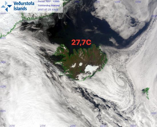
Fagradalsfjall, image from ferlir.is
Iceland suffers from eruptions on average every 3 to 7 years. And in between we tend to look at other volcanoes with interest. And as time goes by we forget that Iceland at any time can have larger and faster eruptions than pretty much any other spot on earth.
During this phase of volcanic unrest we got a lesson about the breakneck pace that Iceland can put in during a period of volcanic unrest. At other volcanoes we can at a sedate pace follow volcanic intrusions and magma movement counted in anything from 100 meters per day, to a kilometre, or so.
But, once more, we are talking about Iceland. And today we got that reminder as Iceland decided that 5 kilometres in about 4 hours is a good pace for magma to ascend. That is by all means a new world record.


Image from Icelandic Met Office.
This is also an intrusion that will give scientific data for the next few years, even if there will not be an eruption. The reason for this is that we have never seen a large powerful intrusion at a Mid Oceanic Ridge at such a well instrumented place. We already have accumulated more data today, than at all other places and intrusions put together at a Mid Oceanic Ridge.
We now know that the initial swarm rapidly transformed from tectonic earthquakes, via volcano-tectonic, to earthquakes consistent with moving magma in a surprisingly short timeframe. As such this is turning into a potential eruption, or a state of volcanic unrest.
This does not mean that it is certain that an eruption will occur, just that the conditions are there for an eruption, if the seismic crisis continues for a length of time. According to previous knowledge an eruption would still be days to weeks away, even for Iceland. But, today we learned that there is indeed a higher gear on occasion for Iceland to put in.

Drumplot by the Icelandic Met Office.
This means that we must shorten the timespan from the start of the intrusion to a possible eruption considerably, if it happens. The normal timespan is 2 days up to weeks, months, or even years. In this case it is though more likely that it would continue at speed.
As such an eruption could be just hours to days away. That being said. If the current unrest stops in the next few hours there will be no eruption, at least for now. In that case we would end up with a Herðubreið situation with continuous small swarms, that ever so slowly moves magma towards the surface at the weakest point.
My personal musings

Let me state that it is the Icelandic Met Office that will make the call, and then it is up to the police and the Almannavarnadeild ríkislögreglustjóra to communicate and enforce it. They are the authorities in charge. I repeat, those are the ones to declare officially what is happening.
That being said, it is time to write what I think is going to happen. Currently the intrusion may end without an eruption. But, at the intensity and force of the current seismic unrest it is likely that an eruption will occur if the seismic crisis is prolonged.

If the earthquake swarm continues at this level an eruption could occur at any time from 8 hours to 72 hours from now. But, remember the IF here.
If an eruption would occur it would almost certainly not be explosive, at worst a VEI-1 to VEI-2. Instead it would be effusive with a fissure opening that could be anything from 500 meters to several kilometres in length.
Lava fountains would be between 100 to 700 metres in height, but fairly rapidly the fissure would shorten to one or a few main craters. At the same time, the eruptive rate would diminish to something between 50 to 500 cubic metres per second.

Intrusion viewed from North/South. Image by Andrej Flis.
Eruptions in this area are known to last for quite some time, so an eruption could cause problems for the road leading from the airport and nearby residents for a prolonged time.
If I was forced to put numbers to a likelihood for an eruption I would say that it is currently below 50 percent, but that number is increasing by the hour. If the hubbub is still going at this rate in the morning I would give a higher number.
We will be following this event closely if it continues, and we hope to publish new seismic plots tomorrow as IMO divulge new data.
Happy volcano watching unto all!
CARL REHNBERG
https://www.facebook.com/Almannavarnir/


Andrej promised new plots as soon as it is possible tomorrow. He fell asleep after having plotted away all evening 🙂
Hmm, the plot thickens.
Yes, puns! They feed me! either way, it seems Iceland is now aquake.
The situation is flowing with fiery interest!
I’ve never been to Iceland. what’s it dyke there? a lot on it’s plate? probably not its fault.
*groans* These puns have explosive potential to get ridiculous xD
so this is sulfur not?
Please pass him my thanks. Impressive.
Currently at least 12 earthquakes above M3… Milky Way indeed.
Katla got jealous, star number 13…
And a 4.7 way out west of Iceland!
Katla had a M3.3 and a whopping M4.4…
Iceland is taking a beating today.
oh boy. volcanic unrest indeed.
It’s suitably stormy where I live right now!
same. I’m a weather nerd too, so it’s perfect!
Just to clarify, if an eruption does happen, what volcano name should it be assigned to? According to the futurevolc site, it appears that Fagradalsfjall is part of the secondary fissure system of Krysuvik; directly to the NE are cones which I think are from the 12th century eruptions, and it is surrounded by lavas from the main part of Krysuvik. Anyway, there’s a report on VolcanoDiscovery of a little flurry in the same location from 2012, and of course the uplift of 2008/9, so to me it appears to be Krysuvik which is the volcano that should be applied, which it will be listed under if the IMO raises the alert level.
Thing is that we never really know these things until an eruption starts. And the magma has not moved from Krisuvik, instead it is going straight up.
Other papers state this as Fagradalsfjall/Keilir volcanic field. I tend to go with the data, so for the time being Krisuvik is out of the suspect list since it is not feeding the magma.
So it means we have, another volcanic system to add to the active list for Iceland, that makes it 44 now! I suppose if the eruption does happen, analysis of the lava composition will tell us if it is indeed separate from Krysuvik.
It would be pure MORB if it erupted now. Krisuvik is varying degrees of evolved MORB.
Thanks. I had wondered about that too. It’s almost square on top of the spreading plate boundary. Icelandic plumbing never ceases to amaze.
Regarding which vulcano it is interesting to know that a huge shield of lava named Þráinsskjöldur (Thorin´s shield) came up in the area north-east of Fagradalsfjall about 9.000 years ago. Þráinsskjöldur is one of the most productive volcanos in Reykjanes – although perhaps not so noticeable.
Thorin II Oakenshield, is son of Thráin
so if it’s a new shield volcano eventually perhaps this should be
Þorinsskjöldur 🙂
Good point!
Or Þórir Eikarskjöldur 🙂
Wednesday
26.07.2017 22:18:13 63.663 -19.084 0.1 km 3.6 99.0 8.5 km ENE of Goðabunga
Wednesday
26.07.2017 22:15:30 63.660 -19.130 5.6 km 4.4 50.5 6.3 km ENE of Goðabunga
Updated:
Wednesday
26.07.2017 22:18:13 63.663 -19.084 0.1 km 4.5 99.0 8.6 km ENE of Goðabunga
Wednesday
26.07.2017 22:15:30 63.660 -19.130 5.6 km 4.4 50.5 6.3 km ENE of Goðabunga
This is this first time I’ve reacted to Icelandic unrest with an utterance of OMG since Bardarbunga! Did someone book a double headliner? 😀
might i ask for a bit of info on Goðabunga? like where it’s at?
Myrdalsjokull?
Roughly, that triangle with the orange and blue dots touching it. Midway between katla and eyafallajokull. It’s a cryptodome.
A rough location from an old graphic, location has been tweaked since, but it gives a rough idea.
Iceland is being triggered like a feminist at the moment! Makes sense since the Iceland women’s football team played today! xD
Could we refrain from comments like this. It is pretty inflammatory. Remember the “Be nice-rule” /Admin
Um… okaaaay…
wtf
Released from being spammed! – Admin
😀
makes me think of waiting for a bus, long time nothing then suddenly two appear on the horizon – question is whether they actually arrive or deviate en route (i.e. nothing happens)
(long term follower, back to 2010 but rarely post as other know so much more than I do)
(Comment brought back from the netherworld; Lugh)
3. there may be three…
The Reykjanes, Katla stars and the 4.7 to the west are lined up like Orions belt on the N Atlantic view on the Icelandic Met Office website. Hopefully not a big fissure eruption.
Hmm. I knock off watching Stromboli’s fireworks to find that Iceland has gone bonkers. I’ve never seen such a ramp up of activity. I’m curious to see where this leads. I’m also curious, Carl, as to the meaning of “MORB”.
“Mid-Ocean Ridge Basalt” is my guess
Bjarki is right in his explanation of MORB.
Mid oceanic ridge burst?
and now it seems pretty regular regimen every 3-4 mins up to a M2
Moving ‘liquids’?
what is the question in this?
Considering the drumplot Carl posted above, there seems to be a magmatic component in the quakes.
that, along with uplift if i had to guess. after all, he gave a rather specific estimate on how much magma was intruded thus far.
Nah, I was specific on the “how far”, not the “how much”…
i just had an idea that could be either brilliant or absolute lunacy. I’ll get to the point: why not open a volcano café discord server? It’d be perfect for keeping the comments discussion rolling since the replies show up automatically. this way we wouldn’t have to continuously refresh the page to keep up with the comments, and could have voice chat as well, if you’re into that.
Something to add to the ever growing list of plans! 🙂
An update on Grimsvotn is in the works as far as I know. Can’t state a due date though. The other systems have no update currently as not much of interest is happening.
great. i could create the discord server easily if you wanted.
Only Administrators are allowed to do things for VC. And we always remain ownership of all things, and control all things. We learned that the hard way, and that rule is not going to change anytime soon.
Okay, that’s fine.
So – which webcams should we all be glued to obsessively for the next few days?
katla, any we can get for this situation, and anything on Goðabunga
edit: the Goðabunga stuff is referring to katla. the more you know.
Do we know anything about how gas rich eruptions from this system have been in the past? If a particularly gassy eruption would happen this close to Reykjavik, that could get quite… …uncomfortable.
we do not. we don’t have much data on this particular system, if my reading of the posts is correct.
Since it is a MAR-driven volcano erupting Mid Oceanic Ridge Basalt it will not be as gassy as for instance Bárdarbunga or Grimsvötn, but gassy enough. It will though not be explosive.
I am already looking into flights up there. I lived at the base in the mid 90’s and spent so much time in that area learning about the volcanism. I figure this is a once in a lifetime event and a look at mid ocean ridge volcanism at it purest. Plus, we get to learn about volcanism on the peninsula. I know there are “central volcanoes” there but I am sure the way it works is much different than in the area of the more established central view volcanoes that also house a caldera and an apparent “magma chamber.” I think the peninsula volcanism is more involved with smaller magma bodies and intrusions that are involved with these rifting episodes. In any case, this should be very interesting even if an eruption does not happen.
(Brought back from the Netherworld; Lugh)
no, it operates on generally the same principle. many Iceland central volcanoes are rift based, so even these rifting volcanoes can have long-lasting magma chambers, and thus be polygenic.
I disagree, there are differences between MAR-driven volcanism and the regular volcanism that is plume-driven. Both in chemical composition and in behaviour. To date we have no instrumented example of a pure MAR-driven eruption.
I would definitely go if an eruption started to study it. I have never seen a Mid Oceanic Ridge erupt before.
What’s the history of volcanic eruptions in this part of Iceland?
Thou art released from the cookie jar! – Admin
Have a look at the following:
http://www.volcanocafe.org/reykjanes-volcanic-field/
http://futurevolc.vedur.is
So, what’s the latest?
wish i knew
speaking of, is there any updates in some other possibly eruptive systems, such as the grimsvotn-haabunga system, Herðubreið, Theistareykjarbunga, or askja?
It’s business as usual for those systems afaik
Probably a silly question with this intrusion being a bit of a surprise.
But if something does happen, are there any webcams around that we could watch it on?
Released from the spam bin – Admin
I don’t think so, but they’ll soon put one in if it kicks off.
Wife has seat on a flight Gothenburg to Iceland sunday morning. Hope we know more by then!
If an eruption would occur she would probably land at another airfield and be bussed into Reykjavik. It is though depending on the wind direction.
Good to know there are optional airfields!!
Well Keflavík is the only really big one, so it will also depend a bit on what size plane is being used, the landing strip at Keflavík is 3065m while the one at Reykjavík Intl is only 1567m.
Waiting to see if Bard has something to say. Usually wants attention when rumbling is happening elsewhere. 😁
If you look at the cumulative seismic moment plot for Bárðarbunga, you see that it has been pretty much stalled for a while. Given the behaviour from the last 2 years, I would expect something like an M4 any day now…
The real question is will we get to watch another sheep blow off camera?
Hmm, yes. a volcano café necessity.
It looks like activity might have tailed off… 🙁
“If the current unrest stops in the next few hours there will be no eruption, at least for now”. So that’s that then. Party’s over; as you were…
still going and looks IMO are catching up, current quakes roughly 7km deep, so looks like any magma movement may be stuck?
It seems it may be picking back up a little. Swarms can have pulses.
I agree, large energetic swarms tend to be in pulses, we will have to wait and see. Also, earthquakes have a tendency to become slightly less energetic when magma has started to move.
It is for now a waiting game.
Latest looks like between 2 and 5km.
As Carl says, it like there maybe a conduit or should I say wedge?
And the answer to that should be revealed later tonight.
Really busy right now but here is a quick updated map
https://vatna.carto.com/builder/ff25fb51-ead1-4bdb-91e3-0f77c5771d31/embed
Please can any one post the link of the nearest drumplot? Thank’s!
http://hraun.vedur.is/ja/drumplot/drumplot/ stations gri and kri
corr stations grv and kri
http://hraun.vedur.is/ja/skjalftar/silstn.html
Thank’s a lot!
Another star when corrected i think:
Thursday
27.07.2017 14:31:35 63.909 -22.303 2.3 km 2.8 90.02 1.6 km WNW of Fagradalsfjall
It will also be interesting to see how magma travels through the ground in this area because at depth the magma comes up I believe through the actual rift fault stress field, where the surface faults are all perpendicular in accordance with stress added from the SISZ. The actual system is basically east-west at depth, but the surface stresses are close to north-south along en echelon fissures and faults.
[Wrestled back from Akismet’s fangs / Admin]
interesting – so it could be open at a lower level due to sisz rifting but closed higher up (I was going to write ‘closer to the surface’ but ‘closed closer’ looked wrong) due to lack of north south tension at the moment.?
no eruption now.
Please.
I’m going to Iceland end august.
sniff
you don’t want to eruption watching?
yeeeah.
but end august.
and only an eruption for tourist……….
it should last a while, so if you do want to see it you might still be good.
13 stars:
Thursday
27.07.2017 14:31:35 63.903 -22.302 5.7 km 3.0 99.0 1.4 km W of Fagradalsfjall
What’s the significance of the earthquake to the west of Iceland undersea? Seems a coincidence Kayla, krisuvik, and the undersea eq occurring around the same time frame.
Katla I meant.
After suddenly shooting up to around 4.5 km below the surface around midnight local time it seems to have leveled out there.
Perhaps it lacks the drive to reach the surface?
it’s probably going to take a few pushes to make it. we just have to wait and see if there’s another surge.
Never mind that. I misread something.
It seems activity used to vary wildly around 4 km below the surface. But then around midnight dropped to around 7 km while getting more focussed.
If there is any ash column during the eruption it’s certainly going to mess with trans-Atlantic air traffic.
(I have a sister and niece returning from Italy shortly to visit us. The timing might have been a little better)
(Saved from the Netherworld/Admin)
Ash, how often does that happen with basalt? Don’t you need water or ice?
yep, generally. this will most likely have little to no explosive content unless some ground water enters the system or it for some reason waits till winter.
I wouldn’t expect a lot, but the possible eruption site is close to the airport so even small emissions could periodically interfere with the airport at low altitude. Early on ground water could be an issue as long as this volcano has been dormant.
(There are some lakes nearby. Do any of the features near the probable fissure have any water?)
Nothing of significance it seems https://ja.is/kort/?type=aerial&page=1&q=fagradalsfjall&x=342935&y=382982&z=5
i do not foresee any phretomagmatic activity. it should be dry and remain effusive.
As I understand it, and IF an eruption takes place, it will most likely look a lot like Holuhraun a couple years ago. Long fissures with fountains coalescing down to a small number of main vents with a lot of runny lava and a ton of stinky gas…. but little to no ash due to lack of water or ice on top of it.
If you have a look on google maps satellite view you can see the extensive flows from prehistoric eruptions.
I would be far more concerned about the damage to people through breathing the gases as Reykjavik sits pretty close to the likely path of a gas cloud in prevailing winds. During the Holuhraun eruption a 25km exclusion zone was imposed due a 90% risk of hazardous levels of SO2. Depending on where this pops up, if it pops up, it could easily be that close to Reykjavik.
I don’t think we’ll have as much lava output here as we did at holuhraun, but i could be wrong.
It seems the earthquakes are getting closer to the surface again.
Meanwhile, elsewhere in the world: wildlife ignores the continuing Bogoslof eruption. The seals are congegrating on the warm ash. They may have a slightly different view of health and safety than we do.
Are saying it sealed the deal, or are you Aleutian to something else?
It is a volcanic seal of approval.
Groan..
my puns rock, i pumice!
Let’s int-erupt this conversation
awe, that’s ashame
Poor things. I hope they don’t fall victims to volcanic activity. I see one of them (over on the left) has brought a nice orange beach ball with him (or her).
Thinking out loud here so shoot me down if I’m way off target. I read on the Icelandic Review website that Iceland is suffering a ‘heat wave’. Has the flow in streams from the Mýrdalsjökull glacier increased? Would this explain the shallow large quakes to some extent as weight decreases on the underlying rock with an up lift force from below?
You mean this?
I’m guessing that’s photoshopped.
Use Google, look up Twitter, learn Icelandic, check the interwebs Ye of little faith…
More like this: http://icelandreview.com/news/2017/07/26/heat-wave-iceland
But it’s along the same lines.
With these temperatures in the lowlands there would still be an increase over any ice. Got to be a significant change in mass in a short time span?
Just don’t overestimate the amount of ice on Iceland. There’s ice on the glaciers and in the winter it may snow, but even then the influence of the Atlantic Ocean and the Gulf Stream makes that a large part of the island remains snow free. Iceland – climate
OK call me a party pooper, but it looks to me like the seismic unrest in the Peninsula is showing signs of reducing and settling down. Maybe in a couple of days the episode will cease. So what would be the post mortem? A magmatic sill / dyke emplacement that in (months or – more likely – years to come) may revive its journey? Or was it simply seismic movement caused by cold rock and heated ground waters being rattled about by some rifting? I don’t currently get the impression this bout of activity is going to surface.
I shall now stand aside waiting for the slings and arrows (to the knee) of outrageous fortune from those of a volcanically educated nature…
None the less – curious to know thoughts on this.
I would tend to agree. There is perhaps not a lot of accessible magma along the Reykjanes peninsula at the moment. It had a low of eruption 800 years ago but has been very quiet since. It would be good to see what the GPS’s have been doing.
On its own the magma seems to lack the upward force to break through. But it is still busy seeking an alternative weaker path.
It all depends on if it can find one.
If I quickly plot the quakes out on excel it still seems to be gradually rising
For me these two episodes ares nothing unexpected or extraordinary. Both Reykjanes and Katla suffer regularly large swarms.
Reykjanes peninsula suffers regularly large swarms, sometimes with quakes up to M6. It´s both a volcanic zone and a half-transform zone (like SISZ), where large tectonic activity happens every few years. As faults move in slip mode, magma can still find a way upwards. And every few centuries the region seems to alternate between its transform seismic activity and a series of volcanic episodes. Eventually an will happen in one of the Reykjanes peninsula volcanoes. And that will be quite a show.
Katla has also been suffering large swarms, as a run-up to its next big eruption. Interestingly this swarm occurred towards the NE, and this has been happening lately. That region is where the amazing Edlgjá fissure starts. So I take a bit of a worry with this.
Nevertheless Katla activity is shallow, again. So this does not give me a reason to expect any eruption in soon. However, the swarm at Fagradalsfjall (an active volcanic system in my opinion) seems to show that magma moved some kms upwards in the crust.
And there is star number 14. The lucky star. Not counting Katla.
The drumplot is getting noisy… there are strong wind there now?
8-15 m/s
Thank’s! It is suficient to apear on drumplots in this way?
http://www.polmontweather.co.uk/windspd.htm
Might give an idea how strong such winds are Luisport.
My, strumpy volcanoes in Iceland this week. Lady Hekla is such an attention seeker! 😉 now with a 1.4
Not attention seeking, rather likely increased hotspot activity, a pulse (or within Hreppar microplate) is causing all this ‘ madness’
Grimsvotn and Bardarbunga will likely respond too in soon
Is it just me, I can’t post a new comment without reverting to the desktop view as if it’s more a line the submit button disappears? Seems ok if I am replying.
I’m using chrome on a Samsung 6s, Android 7.0
This is a test.
Yep, able to submit fine on Firefox.
Reikjanes quake page: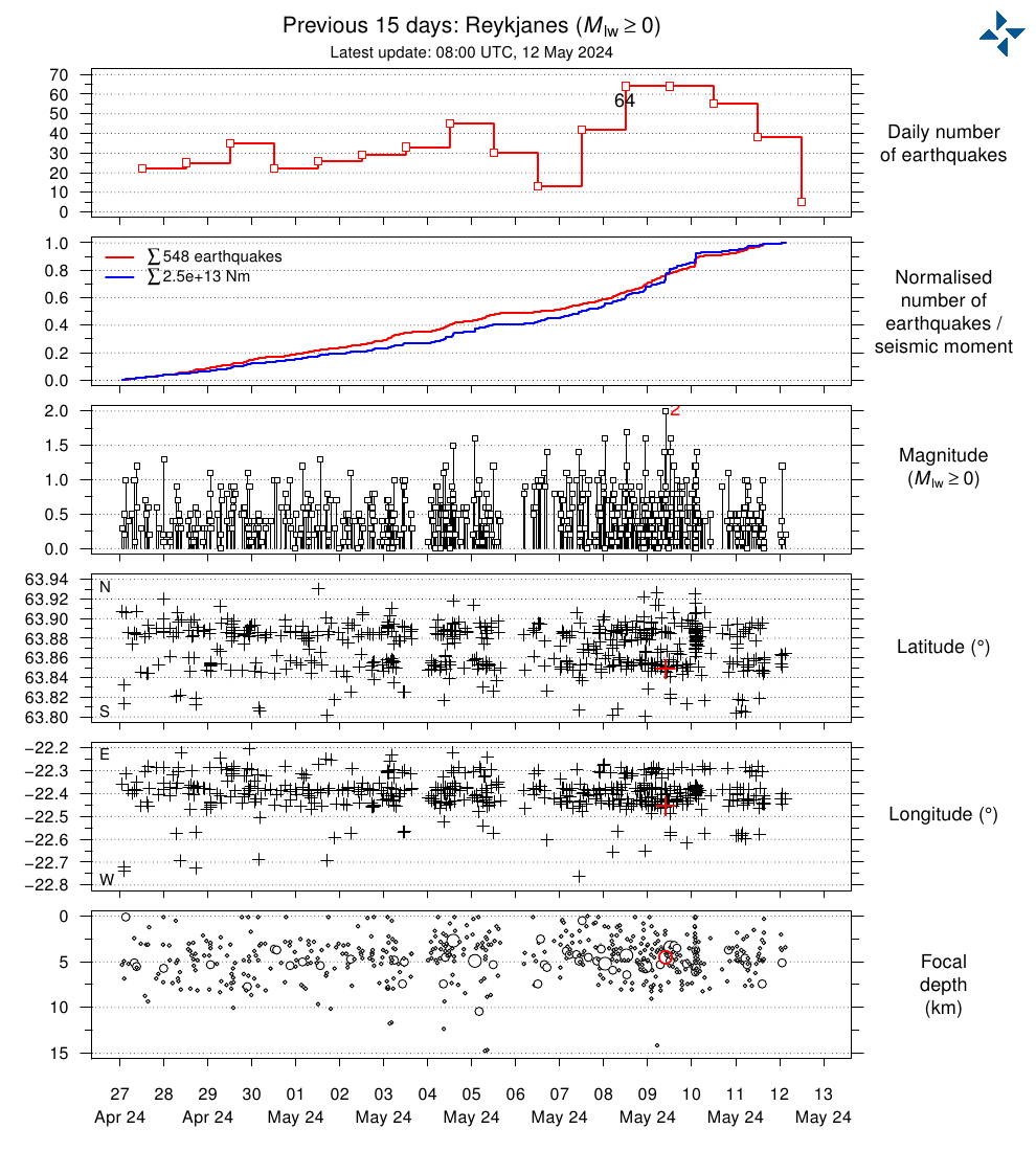
IMO is warning for increased risk of a jokulhaup south of Mýrdalsjökull.
A glacial flood in Mulakvisl is likely in the next few hours
I would publically like to state that I never ever wrote that there was a risk for “Iceland’s biggest eruption ever”.
How on earth could they twist what I wrote around to that…
Anyways, we have been duly quoted by the Independent, and since it is an English newspaper I am now certain that no eruption will happen 😉
http://www.independent.co.uk/travel/news-and-advice/iceland-volcano-eruption-biggest-ever-fagradalsfjall-reykjavik-a7865431.html
I think they may have misunderstood record ascent velocity as record magnitude
They’re only here for the sharknados.
The biggest ever eruption will always be the eruption of lies in British tabloids 😉
Bad luck. And I see they quote you a lot. Perhaps you ought to rerun your article on the Swedish Caldera of Doom. It might give them something to scream over, again.
As promised, here is something new. A full video sequence of the swarm
https://youtu.be/a7rkMNHGV6g
Cool, thanks for your effort. 🙂
Intersting the swarm starts at about 3 km, continues at about 7km, after that the quakes spread between 3 an 8 km.
What data did you use? 99% only?
Thank you 🙂
Yes, I always use only manually verified data (99% quality).
Right, so the sequence is showing a small part of the activity then.
Someone here has a clue how the manual verfication takes place in case of such larger portion of quakes? I mean, what we see in the video could be influenced be a certain grid used verifying I guess ….
Hopefully IMO wil update erified data soon.
Actually this is probably around 80% of the activity up to the time of last quake.
And what is more important, the higher magnitudes get verified first, and they are shown here, and they are most important due to having the highest energy release. The low magnitude quakes that are not yet verified, are of little importance, hence also the verification delay.
So in essence, the quakes that actually matter are in the video 🙂
I get it. 🙂 Thanks for clearing that up.
With my basic knowledge of volcanism, I find it odd that the swarm started at about 3 km. IMO and Carl both did recognize a liquid component in the quakes signature, I read. An intrusion triggered by a tectonic event? Or do I expect to much of the stations earthquake readings regarding precision? Or is the activity mainly tectonic after all?
hi all . katla flood as started confirm by jon
From IMO: “Increased risk of glacial flooding in Múlakvísl river south of Mýrdalsjökull glacier. In recent days conductivity measurements in Múlakvísl river have steadily shown a increased thermal flow into the river which indicates increased risk of glacial flooding (Jokulhlaup). Regional Police have reported above average water flow.”
http://en.vedur.is/#tab=vatnafar
Most promising. Definite reason for a flyover … say no more.
But Ice may be up to 500 m thick and no Glacial deforming showing (yet).
Weather is good, +20 C here today, higher winds from ESE, blowing SW into Mid Atlantic
(may barrier traffic)
That is strong harmonic tremor pulse at Katla, which was registered across Iceland.
meaning?
Harmonic tremor… underground movement of magma!
Probably the minor jokulhaup that was reported to have been occurring today. But could be something else for all I know.
A hlaup wouldn’t cause a tremor spike of that kind, and especially not across 70-80% of Iceland SILs 🙂
Sorry about that something went wrong.
Yellow Color Code for Katla
rescued from the clutched of akismet – further posts should work OK from now
Again, in the light of recent events, I made a graphic of Katla, showing all EQs this year so far. Stars are M3+ EQs. And there are a lot of stars. Katla sure is working hard this year.
It is HD quality, pretty much the highest resolution for this type of plot for Katla you can find in this world. 🙂
And a complete profile for 2017 from south and east.
What is nicely seen right away is deep to mid stacked activity up to around 10km. This could be the extension of the feeder root up under the eastern caldera rim. this is just 2017 data. Combined with previous intrusions which I have tracked, there is already a good possibility that the feeder root is already connected up to 10km at least, not considering the likely previous intrusions before 1997 when my records begin. Also worth of note is a possible magma body/sill complex at around 8-16km depth. All in all its a complex system, tho Katla does take the main prize for having the best looking seismic profile in Iceland.