By Jean-Marie Prival, doctor in volcanology and founder of kīpuka magazine
Like other natural disasters, volcanic eruptions can have an impact on civilizations. Of course they can annihilate them, but they can also contribute to their economic development by providing a valuable resource (obsidian, for example). Finally, they can influence their culture, giving rise to myths. In the case of Iceland, two eruptions may have played a role in the Christianization of the island!

Map of Iceland’s main volcanic systems. The colors correspond to magmas of different chemical compositions, while gray represents rocks of recent age. The systems mentioned in this story are shown in red. CC BY-SA Pinpin, modified.
Let’s first set the scene before diving into Nordic sagas. When the Vikings settled in Iceland in the years 870, most of them were pagans: they worshiped the gods of the Norse mythology. A century later, around 980, Christian missionaries began to preach on the island, but with little success at first. Things changed in 998, when the Norwegian king Olaf Tryggvason converted to Christianity and pressured Icelanders to do the same. The monotheistic religion gained supporters, but the followers of the old faith remained numerous… By the end of the 10th century, Iceland was on the brink of civil war. And perhaps it was the fury of the island’s volcanoes that finally calmed the fury of mankind! Two eruptions, linked to two founding texts of the Viking history, are linked to the Christianization of Iceland.
Eldgjá and Völuspá

The Eldgjá canyon, a scar left in the earth’s crust by the eruption of the Katla volcano in 939–940. A river flows into the canyon forming Ófærufoss, the “impassable waterfall”. CC BY-SA Ilya Grigorik.
Eldgjá, which can be translated as “fire canyon”, is a vast system of eruptive fissures, about 75 km long, stretching between the Mýrdalsjökull and Vatnajökull glaciers. This system is geologically linked to the Katla volcano, located below the ice of Mýrdalsjökull, which is one of Iceland’s most active volcano with 22 eruptions recorded since the 10th century[1]. The eruption of Eldgjá was previously mentioned as having taken place in 934, but a study of Greenland ice cores now estimates that it began during the spring of 939 and continued episodically at least until the autumn of 940[2]. During this event, no less than 18.6 km3 of lava were emitted, 1 km3 of tephra, and 200 Mt of sulfur dioxide[3]. By comparison, the nearby Laki fissure, famous for its eruption in 1783–1784, emitted “only” 14.7 km3 of lava, 0.4 km3 of tephra, and 122 Mt of sulfur dioxide. And as in the case of Laki, Eldgjá’s eruption had a severe impact on the climate, caused by the massive amount of sulphur aerosols absorbing solar radiation. In a reconstruction of Northern Hemisphere temperatures based on tree rings[4], 940 was the tenth coldest year in the last 1,500 years, with −1.38°C compared to the average (in the same study, the Laki eruption ranked 14th with −1.27°C). This cooling is also shown by various historical chronicles mentioning the particularly harsh winters of 939–940 and 940–941, famines, and livestock mortality.
Völuspá, or “Prophecy of the seeress”, is the best-known work in the Poetic Edda, a collection of anonymous poems in Old Norse that forms the base material of Norse mythology. In this poem, a soothsayer tells Odin the story of the creation of the world, then its apocalyptic destiny: Ragnarök. There have been numerous translations of the text over time, sometimes with significant variations between versions—underlining the difficulty of translating poetry, especially when the original language has been dead for several centuries. Nevertheless, the general layout remains the same. Völuspá consists of 66 stanzas of eight verses each. The one of particular interest is stanza 57, which takes place just after Thor, having defeated the snake, walked nine steps before succumbing in his turn. Here is a translation of this stanza by Henry Adams Bellows:
The sun turns black,
Earth sinks in the sea,
The hot stars down
From heaven are whirled;
Fierce grows the steam
And the life-feeding flame,
Till fire leaps high
About heaven itself.
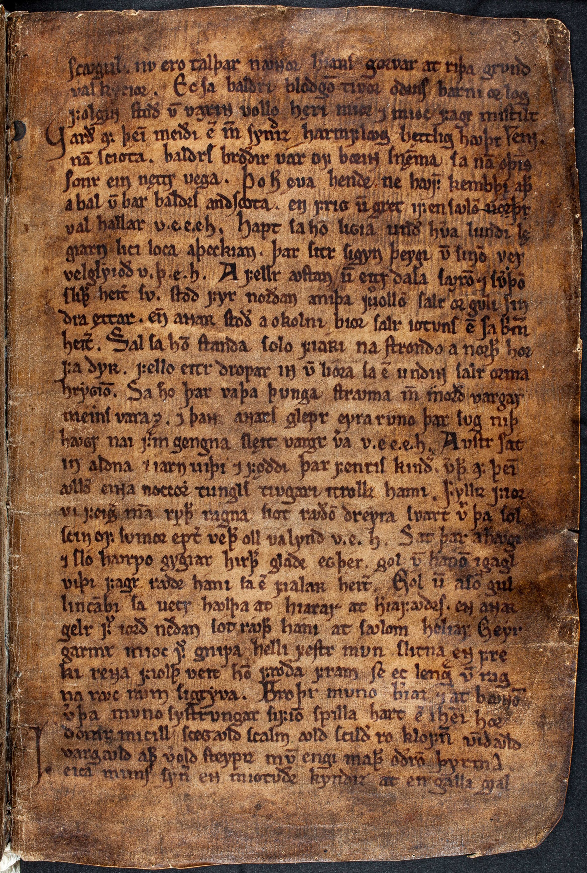
A page from the Codex Regius, a precious Old Norse manuscript written around 1270, which is the only copy left of the Poetic Edda. The Árni Magnússon Institute for Icelandic Studies.
The darkening sky, the steam, the flames… All this strongly suggests a volcanic eruption. The Völuspá is not precisely dated, but scholars agree that it was written around the year 1000. An international team, led by volcanologist Clive Oppenheimer, thinks[2] that the events related in the poem were in part inspired by the Eldgjá eruption. After these apocalyptic descriptions, the world is reborn, and the “faithful […] for eternity will enjoy happiness”. Then follows this stanza, the penultimate:
There comes on high
All power to hold,
A mighty lord,
All lands he rules.
Some see this description as a representation of Christ. Völuspá would then be a prophecy of the replacement of paganism by Christianity. This stanza is the subject of much debate. It could be a late addition, subsequent to the original poem. In any case, some researchers propose that the eruption of Eldgjá served as material for the composition of Völuspá, and that this, in turn, would have served as a breeding ground for the Christian proselytizing that was happening in 10th century Iceland. In this hypothesis, the link between volcanism and conversion is admittedly tenuous, but it does exist.
Brennisteinsfjöll and Kristni saga
But another eruption and another text forges a link between the two events. Kristni saga tells the story of the Christianization of Iceland. This text, probably written in the 13th century and preserved in a 14th century manuscript (Hauksbók), recounts the rising tensions between pagans and Christians at the end of the first millennium. The conversion led by missionaries on behalf of King Olaf came up against a party loyal to the old Nordic pantheon. Tensions between the two sides led the country to the brink of civil war, as shown by this discourse from Þorgeir Ljósvetningagoði Þorkelsson, the “lawspeaker” of the time, that is, the president of the Icelandic parliament (Althing)[6]:
“And it seems advisable to me not to let those who oppose each other here with most vehemence prevail, and let us arbitrate between them, so that each side has its own way in something, but we all have the same law and the same religion, because this will prove true: if we tear apart the law, then we tear apart the peace.”

OA 10759
Thingvellir painting
It is rather ironic that this ideological tear was set against a geological tear: the Althing met in Þingvellir at the time, where Iceland is dramatically split between the North American and Eurasian plates. Anyway, both parties agreed on one thing: Þorgeir was right, one law, one religion, was needed for the good of the island. Kristni saga then tells this story: when Hjalti and Gizurr, the envoys of King Olaf, had just eloquently addressed the assembly, a man came running up and announced that an eruption had just occurred, engulfing the house of one of the leaders of the Christian party. The pagans saw this as a message in their favor: “It is no wonder that the gods are enraged by such talk.” To which the Christians replied: “What were the gods enraged by when the lava we are standing on here and now was burning?” (see footnote) Did the argument work? The fact remains that the lawspeaker Þorgeir, himself a pagan at the time, was asked to settle the debate, with both factions promising to abide by his his judgment. He isolated himself for a day and a night and, after reflection, proclaimed that all Icelanders should be baptized and believe in one God. Concessions were made to the pagans, who were allowed to retain certain traditions—eating horse flesh, for example—but these were abolished a few years later…
The cause of this eruption has since been identified as Brennisteinsfjöll, another fissure system in southeast Iceland, which last erupted in the 14th century. It’s flow is known by two different names[7]: Kristnitökuhraun, “the lava of the taking of Christianity”, which seems logical; and Svinahraunsbruni, “the burning pig lava”, the meaning of which is lost to me… For readers with Icelandic friends, there’s undoubtedly another story to dig into!
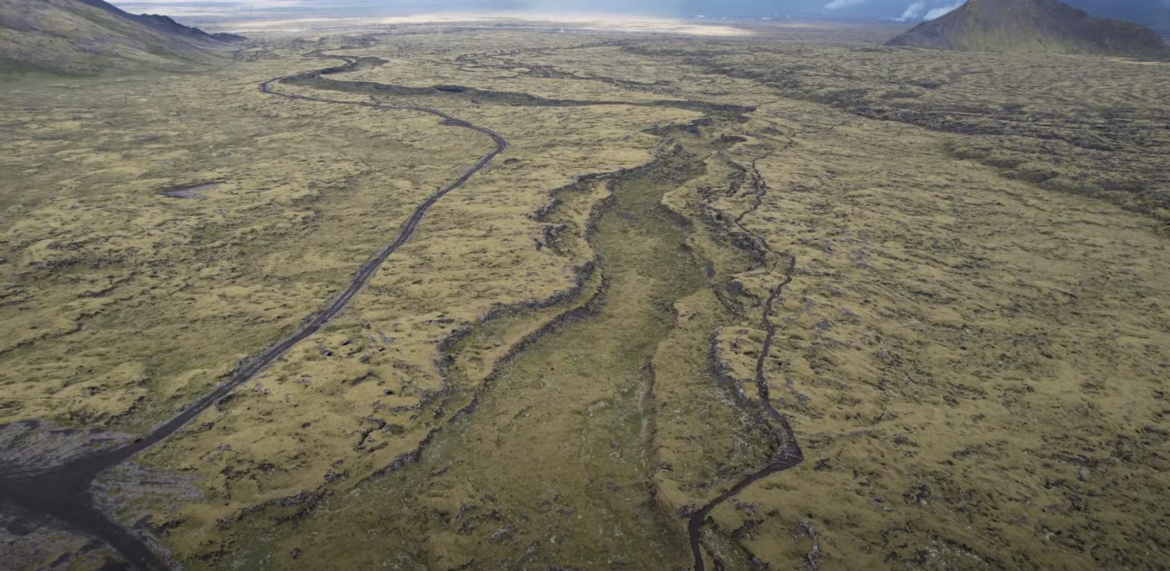
Kristnitökuhraun, the lava field associated with Iceland’s conversion in the year 1000, extends its ramifications into the plain, crossed by the island’s main road. Screenshot from https://www.youtube.com/watch?v=GS6j3TBPOCg (Gutn Tog)
What about Goðafoss?

If Goðafoss is worth a visit for its grandiose site, its “history” is a recent invention. CC BY Marco Verch.
Goðafoss (“waterfall of the gods”) is a beautiful waterfall in northern Iceland, dropping—obviously—from a basaltic cliff. It takes its name from the fact that Þorgeir Ljósvetningagoði Þorkelsson, after proclaiming Christianity as the island’s sole religion, threw his idols of the Nordic gods there. However, there is no mention of this episode in any of the sagas, although it is mentioned by a lot of guidebooks and tourist information websites… In fact, it would appear that this myth was fabricated in Denmark at the end of the 19th century.
This article was originally published in kīpuka, a quarterly, popular science magazine about volcanoes (in French). https://www.kipuka.fr [kipuka.fr]
References:
[1] Larsen G, 2010. Katla: Tephrochronology and Eruption History. In: Developments in Quaternary Sciences 13, Elsevier, doi:10.1016/S1571-0866(09)01303-7
[2] Oppenheimer C, Orchard A, Stoffel M, Newfield TP, Guillet S, Corona C, Sigl M, Di Cosmo N, Büntgen U, 2018. The Eldgjá eruption: timing, long-range impacts and influence on the Christianisation of Iceland. Climatic Change 147, doi:10.1007/s10584-018-2171-9
[3] Thordarson T, Miller DJ, Larsen G, Self S, Sigurdsson H, 2001. New estimates of sulfur degassing and atmospheric mass-loading by the 934 AD Eldgjá eruption, Iceland. JVGR 108, doi:10.1016/S0377-0273(00)00277-8
[4] Stoffel M, Khodri M, Corona C, Guillet S, Poulain V, Bekki S, Guiot J, Luckman BH, Oppenheimer C, Lebas N, Beniston M, Masson-Delmotte M, 2015. Estimates of volcanic-induced cooling in the Northern Hemisphere over the past 1,500 years. Nature Geoscience 8, doi:10.1038/ngeo2526
[5] Bellows HA, 1936. The Poetic Edda. Princeton University Press
[6] Grønlie S, 2006. Íslendingabók. Kristni saga. The book of the Icelanders, The story of the Conversion. London: Viking Society for Northern Research, ISBN 978-0-903521-71-0
[7] Gudmundsson A, 2017. The Glorious Geology of Iceland’s Golden Circle. Springer, ISBN 978-3-319-55152-4
Footnote: This passage has interesting implications for the geological knowledge of the 10th century Icelanders. In Europe, at the end of the 18th century, the debate raged between proponents of Neptunism, who considered basalt to be a sedimentary rock formed under water, and those of Plutonism, who saw it as the result of volcanic activity. Perhaps the Icelanders had already settled the dispute eight centuries earlier!


Iwo Jima is doing pheratic eruptions looks also like lava is extruded in the water
https://mainichi.jp/articles/20231030/k00/00m/040/165000c
Just in time for Halloween perhaps?
Whats looks extruded in the water is probaly just mud thats been uplifted or piled up, there is No steaming in that so its not a lava flow at all thats emerging
It does say there is pumice there and I watched the video, confirming that there is pumice, which would mean there is at least some magma in there. This one looks quite different from the other “eruptions”. Is something changing?
Okay, looks it it had done something like this many times, at least according to the not-so-reliable source Wikipedia.
https://en.m.wikipedia.org/wiki/Iwo_Jima
So, this might be normal routine but I wouldn’t be surprised if this is the one that broke the camel’s back.
This is a Sentinel image taken ten days ago. It shows a spot in the ocean with a bit of trailing discolouring. That spot is probably not far from the eruption
https://www.volcanocafe.org/iwo-jima-in-45-eruptions/
It seems the area is close to area number 10. Also, based on the satellite, I may hypothesize that it might be a fumarole of some kind…
I may even go further to hypothesize that there might be some smaller secondary magma body (sill) that underlies the area. Also, according to the report Jesper shared, they confirmed that there are black rock blocks, which could indicate older ejects or a lava bomb of basaltic or andesitic composition, but the pumice kinda throws that off.
Just dark clumps so steaming lava chunks thrown out.. No pumice here pumice thats magma glass gas foam require far more eruption violence vigour
I guess this is probaly just normal small pheratomagmatic eruptions that happens in the area, this eruption probaly will be dead tomorrow, but clear signs that Iwo Jima is charging up for perhaps another caldera forming eruption, or perhaps effusive Island building like Nishinoshima coud be om the horizon 🙂
Interesting! There have been previous explosions in this location but normally quite brief. This looks more extensive
Also noticed the article mentioned some areas had uplifted over 10 meters in the last decade. On the macroscale Iwo Jima is a pretty steady ticking bomb, but it certainly has its short-term ups and downs. Like 1980-2002 was basically no inflation. Then in 2011 obviously another pulse came in based on the earthquakes and increase continued after that. https://earth-planets-space.springeropen.com/articles/10.1186/s40623-018-0811-y. But pretty clearly there has been another spurt since 2018.
Incidentally Kangoku-iwa may not be very long at all for this world if this growth spurt continues. Its undergoing the same thing Kamaiwa did. Long-shore movement from erosion at the north end of Ioto settling down in the calmer waters behind the island. So far in the 2000’s spurt over half the width of the channel has been covered at the south end. Its really impressive! Looking at the bathymetry compared to satellite, some of the new dry land there was 40 meters or so underwater 20 years ago. 10 or so probably inflation, rest depositing. Of course just a pale shadow of Chidorigahara, which comparing to similar places around the caldera rim must have had at least 100 meters dumped before it emerged from the waves.
Its interesting how you can see the influence of both the prevailing winds and small islands forming quieter areas (because when water is calm larger sediment grains will fall out) . Presumably the dominate wind/wave pattern doesn’t meaningfully change. But while general direction of deposit is SE, the angle toward Mt. Suribachi is much more south than the angle to Kamaiwa, much less Kangoku-iwa. Once Kangoku-iwa connects, that channel will fill up fast as a dead end, even though it is nearly 90 meters deep in the more northern part. After Kangoku-iwa there is the barely underwater ridge to its NW. After that sediment will just be ‘wasted’ in 300m deep water, though there will be less sediment by then as the north of the island is slowly in terms of shape becoming perpendicular to the erosional forces.
 ?resize=1024%2C901&ssl=1
Look like that new vent is close to the 2022 vent.
Another phreatic eruption I expect, from water interacting with the shallow magma chamber, may have pushed up some old tephra in the process.
Very nice post! The lack of historical information on Eldgja has always seemed a bit of a mystery. It must have been devastating, yet the only thing we have is the imagery of the Edda. The settlement era ended at about the time of Eldgja, so perhaps that was because Iceland was becoming uninhabitable. Shortly after Eldgja, some 10% of Iceland’s population migrated to Greenland. Perhaps that too is telling.
Iceland was also much colder before in Icelandic human history than it is today, the Gulf Stream was much further south during the little Ice Age and other cold periods before Industrial age, reading that Iceland often sat in polar waters rather than temperate like today.. so it woud have been much colder in winter and summer than it is today. Today sea temperatures in Iceland is around 7 c to 12 c thats quite warm and explains why Vestmannaeyjar and Keflavik have one of the warmest winters in all of Northen Europe, reduce that to 2 c during cold periods and coastal summer temperatures will plummet perhaps so much that agicultural activities gets difficult. Today Iceland is heading the other way.. and probaly will become as warm as Ireland in 60 years
Iceland is souch a incredibley unique and beautyful Island country and as nordic citizen Im free to move at anytime, just wants to find a job skill first, I dont want to be anywhere else now.
I remember reading somewhere a while ago that Iceland has plans for a major shipping port in its north somewhere, because if expected increase in Arctic shipping as the north passage through Canada becomes permanent. Or even the ocean itself, which will soon be ice free in summer.
I expect occurences of polar bears on land in the Arctic will greatly increase, or that of pizzly bears, their hybrid with grizzly bears. Pure polar bears may well disappear not long after this point though 🙁
I have seen some videos that warmer temperatures are encouraging the growth of forests in Iceland, still early days of course. The forests were cut down but possibly the harsh climate of the little ice age is what prevented them growing back in any significant way.
Whats really preventing forests to grow in Iceland is the low summer temperatures, but thats changing now with its getting up to 20 and above in the interior and coast gets up to 19 c in high summer. Trees can survive incredibely low temperatures in winter as long as summer is warm, larch have been submerged in liquid nitrogen for quite some time in experiments and the trees have still been viable afterwards in warm summer conditions. Siberia have an immense continentality.. and that allows it to get pretty warm even in the arctic in summer.. they recorded… +50 C! in the tundra region a few years ago, and the regions just south below that is always warm in summer.. yet deeply frozen in winter and that allows trees to grow.
But once you haves a cold summer then the trees dont like it.. but Iceland is warming up now so fast in summer that the lowlands perhaps should remove their subarctic oceanic classification into a “oceanic temperate climate”
I remeber reading earlier about Reykjaviks Bay being choked by Ice in the 1600 s during a cold current, thats impossible today as the warm Gulf Stream is present
Polar Bears and Grizzly Browns are indeed very closely related and the offspring are fertile too, so little like humans and neanderthals. Polar Bears very sourthen range is in James Bay in Canada at latitude 49 .. thats bears as far south as London in Europe, the warm Gulf Stream completely prevents the north Atlantic from freezing.. so explains why polar bears are not seen in Iceland or in Scandinavias mainland only in Svalbard. They are sometimes seen in Iceland as they drift over from the north with icebergs with the Greenland current and are usualy shot when they land in westfjords.
…New view from webcam at Thorbjorn looking over the Svartsengi Geothermal Power Plant, the magma inflating area…I guess the Blue Lagoon coud be destroyed if it erupts there, shame I cannot be in Iceland yet as Im too busy
https://livefromiceland.is/webcams/fagradalsfjall
Iceland’s climate is very sensitive to the Gulf Stream. I think around the year 1000 it was fairly mild (probably not as warm as now). A few centuries later the glaciers were expanding and ice reached the north coast of Iceland as the warm current was replaced by the cold one. I think the southernmost reach of polar bears is linked to this cold current?
Looking up a bit more information, polar bears are seen in Iceland on occasion and were quite frequent during the cold period in the 19th century. They still visit every few years or so. But Iceland has a way to deal with them. They may be shot. I guess Iceland is quite close to America.
Quite true, Albert. If you check out the Jokulsarlon Lagoon, you will find out that this lagoon is very recent. The depth of the lagoon indicates the true plowing effect of the glacier ice feeding this outlet, but to have this lagoon develop so quickly is very remarkable.
Last winter was insane in coastal Iceland when Greenland air flow blockaed the warm air, then they had almost – 20 c in keflavik and reykjavik got below that, thats very rare in souch an oceanic location that usualy is around 3 to 6 c in winter, the icelandic interior got to around – 41 c around the holuhraun area anyway the interior is far colder than the coasts as Iceland is large enough for for forming its own mini polar airmass. The coasts in Icelands south are normaly the warmest winter locations in the world at latitude 63 and 64 westman islands often have +7 c in deep winter, something almost unkown elsewhere at latitude above 60
Now Earthquake swarm near Porbjorn.. we will see if this is the eruption fuse as inflation have gone over here now, yet it does not seem as intense as the previous magmatic svarms, eruptions in this area are like wolf 2015 som woud be very fast intrusions in intensity, so perhaps is just a earthquake svarm for now
IMO’s modelling suggested an intrusion at a depth of 4km yesterday. However, they were waiting for satellite data.
Source: https://en.vedur.is/about-imo/news/a-seismic-swarm-started-north-of-grindavik-last-night
If this is an intrusion, looking at the swarm now, the magma may have ascending to nearer to 3km now. If there is a > 4.5 M earthquake, I’d be dusting off the tin hat, just in case.
Given how close the power station is to the inflation, would they be able to detect the changes in geothermal energy that precede an eruption? (Hopefully, well before lava emerges).
Maybe lava will erupt out of a borehole like happened at Krafla in 1977 🙂
Seems like the crust here is very different from Fagradalsfjall. For one the heat is at the surface, unlike at Fagradalsfjall, hence why the power plant is here. Intrusions also seem to form sills that pile up at shallow depth, with dikes forming probably only in the immediate run to erupt. But whether this is the cause of the high geothermal gradient or is a result of it is unknown.
Seems likely that an eruption will break out in this area some time soon.
The web cam has been turned to check out the area at the moment.
https://www.livefromiceland.is/webcams/fagradalsfjall
Mind you, the cam is on Þorbjörn so could be too close to any future action to show much.
I know going off Youtube videos is not really a reliable way to research geology, however, Geologyhub created a very intriguing model demonstrating a theory that the magma initially accumulated under Reykjanes volcano before forming a sill and connecting to the Fagradalsfjall magma chamber, rising somewhat and then traveling West back to Svartsengi area after further accumulation. Seems a bit wacky but perhaps a 3D model of the last week’s seismic activity might actually demonstrate this kind of connection. Any thoughts on this ?
Such long sills seem implausible for this region.
Fagradalsfjall eruptions have low dike intrusion and eruption rates, it is a “weak” system not backed up by a substantial storage.
I don’t think it comes directly from the shallow Svartsengi storage because Svartsengi is a quite powerful almost Krafla-like volcano. It possesses shallow storage that powers curtains of fire which run for up to several kilometres in length. Rivers of lava over a kilometer wide all flowing at the same time where big crustal plates tens or hundreds of meters across collide and make ridges of broken rock. Sheet pahoehoe flows that extend up to a few kilometers from the vents (a type of lava very thin and smooth that happens when lava flows quickly from the vents all over the surface as a flood and without developing a thick crust) It’s a higher intensity of eruptions.
What woud Icelands climate and enviroment be like if Reykjavik was at latitude 54 and westfjords was at 56? woud there have been a glacial history? not soure how much warmer it woud be, but coastal areas woud be pretty much frost free althrough not very warm in winter.
Moving Iceland north woud make it just more misrable and Vatnajökull woud grow, but the lowlands at coast woud remain quite mild even if it was moved to Jan Mayen, you woud have to move Iceland almost all way up toSvalbard for it to get very cold… beacuse there the Gulf Stream stops
Volcano Chaser on Facebook brought the attention to this paper: “Cyclical geothermal unrest as a precursor to Iceland’s 2021 Fagradalsfjall eruption”.
https://www.nature.com/articles/s41561-022-00930-5
Unfortunately, it’s behind a paywall, but the abstract and the figures tell the main message quite well:
Abstract:
“Understanding and constraining the source of geodetic deformation in volcanic areas is an important component of hazard assessment. Here, we analyse deformation and seismicity for one year before the March 2021 Fagradalsfjall eruption in Iceland. We generate a high-resolution catalogue of 39,500 earthquakes using optical cable recordings and develop a poroelastic model to describe three pre-eruptional uplift and subsidence cycles at the Svartsengi geothermal field, 8 km west of the eruption site. We find the observed deformation is best explained by cyclic intrusions into a permeable aquifer by a fluid injected at 4 km depth below the geothermal field, with a total volume of 0.11 ± 0.05 km3 and a density of 850 ± 350 kg m–3. We therefore suggest that ingression of magmatic CO2 can explain the geodetic, gravity and seismic data, although some contribution of magma cannot be excluded.”
I think it sounds like a really plausible explanation for the Svartsengi/Thorbjörn inflation. Remember that Carl had a very similar explanation for the uplift at Askja – not all volcanic fluids are magma. I find it very likely that this seismic episode is a precursor for the next eruption at Fagradalsfjall.
Entirely plausible but there is clearly heat close to the surface in Svartsengi and the crust will have been repeatedly weakened by earthquakes. I imagine there is the potential all along the peninsula for a dike to form aligned with the tectonic direction, and it is maybe dictated by fluctuations in crustal strength, or perhaps ancient (or recently produced) weaknesses. This area erupted 1000 years ago, while Fagradalsfjall didn’t.
Does anyone know more about Brennisteinsfjöll eruptions mentioned in the post? This area seems to be the only one from where eruptions could reach close to Reykjavik itself
To reach Reykjavik you either needs a long lived tube feed pahoehoe eruption, or something as big or faster than Holuhraun in eruption rates
It is the biggest of all the volcanoes in that part of Iceland. Hengill might do slightly bigger actual eruptions, but rarely, and Brennisteinsfjoll is a much larger physical structure. The Reykjanes area is supposed to be old, but to me Brennisteinsfjoll appears to be an embryonic system, it has no central volcano and does episodic large eruptions. Actually all of Reykjanes is very young, and a lot younger than the coastline down by Katla, which is supposedly where the rifting is headed…
Basically, picture Fagradalsfjall but it is about 10x as big 🙂
The eruptions seem similar, being long lived and not as intense as at Krysuvik or Reykjanes. But at the same time individual a’a flows go some 8-10 km away from vents that look a lot like they once contained huge lava lakes, the eruptions were probably episodic with high peak effusion rates, like seen in 2021. Some evolved into pahoehoe flows and tubes that went much further, tens of km and indeed into parts of Reykjavik.
There is a part of Krysuvik that goes into Reykjavik. Hafnarfjordur is built on lava from it erupted in the 1150s.
If I remember correctly, the Middle Age “Fires” period on the peninsula started at Brennisteinsfjöll and later moved to more western systems (Krysuvik, Reykjanes, Eldey).
Hengill hat an eruption close to Thingvallir, but it was 1900 ago when Iceland had Birchwoods, but no humans.
Brennisteinsfjöll produces slow eruptions of channelized aa lava, toothpaste pahoehoe, and tube-fed pahoehoe. Most of the volume of the Reykjanes Fires erupted from Brennisteinsfjöll starting around 1000 AD, and maybe lasting a few decades or so. I have some notes on the calibrated radiocarbon eruption ages of Reykyanes eruptions two of the Brennisteinsfjöll events are dated to around 990 and 1010 AD. None of the Brennisteinsfjöll eruptions reached Reykjavik to my knowledge. I talked about the Svinahraunsbruni eruption in my Reykjanes Fires article a while ago.
There were eruptions from the neighboring system of Krysuvik somewhere around 1120 (some decades up or down). One of the eruptions, I think it was called Kapelluhran, was a really powerful event that reached the Reykjavik area. An aa flow entered the sea near Reykjavik in the Hellnahraun area, and towards the end of the eruption toothpaste pahoehoe lavas slowly advanced over what is now the Vellir neighborhood of Reykjavik. This eruption could also be the one mentioned as destroying the house.
A nice volcano cultural article!
If we look on human history concerning volcanoes (and whole nature), we must understand the shift by science. Before science introduced rationality humans had a lot mythical/mystical views on nature. While these views were wrong, they bore (past tense of “to bear”) heavy human fascination and passion for nature and volcanoes. Max Weber, the “Einstein of Social Science”, talked about the modern disenchantment of the world. It has increased our knowledge extremely, but has also lost the historical emotions/passions a bit.
But we also tend to underestimate their knowledge. The post mentions that they were aware how basalt formed (for obvious reasons), something not known in Europe. I have often complained about the strange story that medieval Europe did not know the Earth was round – a story that originated from America in the 1800’s. They knew perfectly well and had done ever since the ancient Greeks.
Greeks of course also had the first accurate measurement of that round earth.
The actual reason of course for people thinking Columbus was funny in the head was he was using very optimistic estimates both of the circumference of the world and the width of Asia. Specifically one mistake was taking an Arab estimate of the world’s diameter and not realizing that Arab miles and Italian miles are very different units of measurement. Combine that with believing some of Marco Polo’s distance measurements for Asia which even most of Columbus’s contemporaries didn’t.
If Columbus had been right, Shanghai would be about where Bermuda is. Which of course is *very* wrong. Of course they didn’t know Bermuda existed, but that is very different from thinking China was there.
Or this lovely map of the world nearly 100 years before Columbus: . One of the other things they knew from the Greeks was that the Atlantic and Indian oceans connected below Africa.
Link didn’t work. Its the De Virga world map from 1415.
They knew even more than that. They knew the approximate distance to the Moon. They did not know the distance to the Sun but knew it was much further away and they also knew that the Sun was much bigger than the Earth. In fact they is why they adopted at one point a heliocentric model where the Earth was orbiting the Sun, because it made no sense that a bigger body was orbiting a smaller one. About 100 years later this model was abandoned again for an Earth-centric one, possibly for computational and engineering reasons (that is speculation) – this was about when the Antikythera mechanism was developed.
Before Newton Science was Nature Philosophy. A few used empirical studies. The Greeks f.e. observed the ball structure of the earth by different solar ray angles at different places on the same date. But the most nature philosophers only used what they found in libraries and mixed it with ideas of their own brain.
Apart from the educated people, the laymen thought that the world is 4-5000 years old and that mystical forces rule the world. The belief in elves still remains in Iceland today. During Christianization the Icelanders disputed whether pagan gods or the christian God manage volcanism. If you believe that a personal intelligence rules nature, it is a very different relation to the volcano than if you believe in the rule of factual physical laws.
In a world that is run by deities (gods, elves, …) we were very vulnerable for their despotism. Better have some reliable and viable physical laws that always work – even if they sometimes are complex like in volcanic systems.
The different angles of sun rays in different locations is the way they measured the size of the Earth, but is not how they deduced the shape of the earth. That was done in different ways. Ptolemy lists four, one of which is that eclipses happen in different locations at different times. The age of the world did not become a problem until we had a way to measure ages, and that was only in the 18th and 19th century. And I don’t fully agree with the rest of your statement either.. (sorry!). Empirical observations were always important. Even to the church, they went above scripture. Read for instance Augustine. Perhaps we tend to project too much of our current conflicts on the past. Icelanders may have had discussions about which god caused volcanoes to erupt, but they knew what would happen if they erupted.
I think it’s related to the “dark age” name, which is nowadays considered a misnomer. It doesn’t help that many teachers propagate the myth that the Middle Ages were an age of complete scientific ignorance or stagnation due to the influence of religion. One simply has to read St Albert the Great to see how important his contribution to science was and how modern he was in his scientific thinking. At the same time there were also several Muslim scientists who made important contributions to science and especially mathematics.
Three current volcanic developments:
1. The swarm near Grindavik continues lively.
2. Kilauea possibly has had some quakes around the ring fault. Do explosive eruptions there become more probably when SWRZ enters an active period? 1790-1823 this happened.
3. Mount St. Helens is back … seismically. Likely recharging earthquakes: https://www.usgs.gov/observatories/cvo/news/uptick-earthquake-activity-mount-st-helens-remains-within-background-levels
I was under the impression that the rift eruptions in the Kau desert in the early 19th century were because the volcano collapsed and cut off the rift zones in 1790, which lead to rapid caldera filling as the magma had no other option. The SWRZ, both components of it, seem to connect better to the caldera so it makes sense the first flank eruptions would go that way. But the ERZ is much more voluminous, so at some point takes over. Except that there is also the interaction Kilauea has with Mauna Loa that seems to have cut it off right at that point in the 1850s. There is no certainty the same will happen again though, and the 2022 eruption of Mauna Loa had the lowest MgO content of any of its recent eruptions, seems far from it taking over it is at its lowest in centuries.
Kilauea is probably safe from properly exploding, but a rift eruption will probably be intense even if not voluminous, and a ring fault eruption now probably will have some big fountains. Keanakako’i is potentially at risk, and usually has a lot of people…
Yes, I thought about Keanakako’i. Between 1800 and 1850 was the last explosive period. “Several
individual events distributed predominantly south and west of the caldera”. The historical map shows in blue lines the distribution of tephra. It was to the south and southwest of Kilauea’s caldera. It covered areas which usually are free of lava risks.
https://www.youtube.com/watch?v=gXCCryILo2A
Nice video showing how fluid 2021 was
Indeed Jesper. That was really fun to watch. The last two were far more of a damp squib. Wondering what to expect from the next one now.
Superfluid probaly beacuse it was very crystal poor so a smooth glass melt like at Kilauea and Nyiragongo, that coud have two reasons, either the lava was so hot that all mineral phases was molten, or it was a crystal poor melt where the crystals had sinked down to the chamber bottom as it came from a deep chamber. Some says 1240 c as temperatures but thats maybe the source temperatures and 1170 c was more likley to be the eruption temperatures But its possible that it erupted at 1240 c so was hot and very fluid beacuse the other stuff was hot too
2022 and 2023 was also hot and fluid But was crystal rich lavas and had difficult to form smooth pahoehoe crust surfaces close to the vents, was very runny in the vent.. But soon outside it took on Holuhrauns crystal rich apparence and indeed these eruptions looked alot like the Holuhraun lava
IMO released another update on the situation:
Updated 31st of October at 5pm
This morning at 8:40 am an earthquake swarm began at Þorbjörn, which lasted for almost 2 hours and was exceptionally intense. The largest earthquake in the swarm measured M3.7. The center of the activity was just east of the centre of the uplift observed in recent days. The depth of the earthquakes was estimated between 5 and 1.5 km depth. The earthquake swarm is a clear sign of magma movements at depth. GPS measurements support the interpretation, although the uplift that started about four days ago has slowed down. Earlier today, there was a meeting with Civil Defense and stakeholders on the Reykjanes Peninsula, where the latest measurements and possible scenarios and responses to the current scenario were discussed.
https://en.vedur.is/about-imo/news/a-seismic-swarm-started-north-of-grindavik-last-night
Maybe it’s time to stock up on popcorn packets?
I doubt it can be too long to wait now. Just hoping it chooses a safer area.
The current area is not only likely to impact Grindavik but even worse if it should impact the geothermal plant close by. A major source of heating for the whole of that area. Not good to lose that with winter fast approaching.
https://www.ruv.is/frettir/innlent/2023-11-01-kvikuinnskot-vestan-vid-thorbjorn-395490
(I prefer the Google-Translation into Norwegian, because it keeps it in the Skandinavian family)
They say there is a magma intrusion west of Þorbjörn at 3-4km depth. They monitored 400 quakes with the strongest at 3.7. It is the sixth intrusion in the region northwest of Þorbjörn. Three 2020 and two 2022. As we all know they happened without any eruption.
https://www.youtube.com/watch?v=CZLxt3QhjQY
Fun video, Earth will be grilled beyond all oblivion, in the far future Earths atmosphere will become alot hotter than a waste incenirator
The sun will destroy us all.. if we do not destroy ourselves before that, Earth will pretty much become like a watermelon thats been inside a huge fire for many hours and look quite similar..
Well Mars will never become habitable, even when it warms up its too small and lacks frequent geological activity and lacks a magnetic field so it will end up even more dead in the far future as it looses its atmosphere completely and cools down even more. So the graphics showing future oceans here are inccorect
Interesting article. “What were the gods enraged by when the lava we are standing on here and now was burning?”. What a way to answer, and also shows they had some understanding of how basalt formed.
On Hawaii news, the 40-30 km deep long period earthquakes of Mauna Loa have been rising over the past days, right now they are the strongest they’ve been for over 5 years. Expect the magma to go up to Kilauea like it usually does. The last time there was a significant surge of Mauna Loa DLPs, although much larger, was in ~2005-2008, when there were also episodes of very strong seismicity along the connectors, as well as extraordinarily fast SWRZ inflation.
https://www.usgs.gov/volcanoes/mauna-loa/past-week-monitoring-data-mauna-loa
So far the DLPs have been rising through 2023, in line with increasing Kilauea inflation and earthquake rates, if we extrapolate this trend then it’s going to get even more lively as we head into 2024.
What are your thoughts on the composition of the 2022 Mauna Loa lava. It is the only eruption I am aware of historically to have less than 7% MgO, which I take to mean it was not fed by a high supply rate in the past few years but a low one for much longer. Even in 1843 which was probably after a longer interval, the magma was hotter and more magnesian. It was very mafic in the 1850s, and generally most of the century after.
Your comment on how Mauna Loa was really active 1500 years ago and Kilauea was almost as alkaline as Hualalai has got me thinking if maybe something similar is happening but in reverse order. Even more so now than a few months ago. Maybe the presence of the huge sills under Pahala is some relation to this, magma that was diverted away from going into Mauna Loa and has got itself into a spot where the only obvious way out is through Kilsuea, eventually.
The 2022 magma was probaly sligtly evolved.. lost much of its magneisum, really unevolved hawaiian magmas are high in magneisum oxides like the Kilauea summit lavas, the low mgo was proably result of years of lower magma supply and sitting underground, still emerged fluid and nearly crystal free in 2022 but without a high mgo content
Yes, when Mauna Loa is less active the MgO tends to go a little down, the 40-year dormancy must have taken its toll.
There is something I’m curious about, there is a particular endmember of isotopic chemistry produced by the Loa volcanoes. A chemistry with low Pb208/Pb204 ratios, and very low Nd143/Nd144 ratio compared to other Hawaii lavas. It is also characteristic that the silica content increases very slightly for a given MgO in these lavas, and they remain strongly tholeiitic. This chemistry was last erupted by Kahoolawe, and before that by Lanai and the final stages of Koolau. I think it is possible that it represents a chemistry endmember when the Loa volcano is strongly dominated by the Kea volcano, similar to how during Mauna Loa (the Loa volcano) was dominant in the 1850-1950 period, Kilauea (the Kea volcano) went for a very high Pb208/Pb204 ratio that is a different endmember in the isotopic compositions of Hawaiian volcanoes. Late Koolau, Lanai, and Kahoolawe were all probably contemporaneous with powerful Kea volcanoes at their peak, East Molokai, Haleakala, and Kohala, respectively. Lanai which displayed the most consistently low Nd143/Nd144 values was possibly contemporaneous with Haleakala’s peak activity around 1.4 Ma, which is probably the most powerful volcano Hawaii has seen since Puhahonu, and one of the few most powerful volcanoes of the Hawaii-Emperor Chain (judging by how far out its plumbing grew). So I think Mauna Loa might go towards this Loa endmember chemistry if Kilauea takes over real strong (I’m talking tens of thousands of years into the future maybe… although we might see small hints on a much shorter scale). The funny thing is that Lanai and Kahoolawe remained relatively strong volcanoes all the way to their demise, with their calderas being well preserved and no alkaline lavas. They were just overshadowed by their more powerful Kea peers
Very interesting, it sounds like the Loa volcanoes are much less typical to go into alkaline volcanism. Which really brings Hualalai into a bit of an outlier spot being that it is a Loa volcano with voluminous alkaline volcanism that has built a whole new shield on top of its original one. Mauna Kea also is likewise a bit of an outlier being a Kea volcano that doesnt have any major rift zones, although it is at least not much of a mystery why that is, it is stuck between two neighbors. Still, it is interesting to consider if there is a connection.
Looking at the Pahala quakes, they look like they occur in a very similar pattern to the quakes happening at the base of the jsland, on the decollement fault. It is probably a parallel deeper structure, and maybe one present at all the islands explaining the random deep quakes that show up on occasion. But Pahala also has magma involved. Prezumably these decollement faults would dip inward towards the middle of the island, which is where Mauna Loas deep source is. Kilauea has its own source, shallower because it isnt as massive. But for whatever reason magma from Mauna Loas deep source is probably intruding the decollement fault and pooling at a break in the slope where the island stops. If it was left to that, possibly tthe ultimate destination of this magma would be a vast undersea eruption, like at the North Arch field. But, in this particular case, there is another volcano that is fed directly through the deeper decollement.
Its all hypothetical of course, but given the fact the Pahala quakes have been seen all through the observation window since 1970, it wpuld be logical to link it with Kilaueas magma supply. I
To go even further into speculation, maybe Kilauea is cheating its growth. It is not all that much older than Kama’ehuakanaloa apparently, and is hardly a mountain at all, yet is an enormous sysyem underground and actually even larger than Mauna Loa in that regard. That it was almost alkaline while Mauna Loa was very active, and even more recently in 1959, similar cause, to me sounds like Kilauea by itself is not what it appears, and it has effectively parasitized its neighbor to get a head start. Its true nature is revealed when Mauna Loa takes charge. Basically, Kilauea might be a transitional early shield stage that piggybacked off of Mauna Loa and grew a lot more than it should have by now. Its true potential is not yet realized, when it takes over for real it may be something truely colossal. Although it remains to be seen if Kama’ehuakanaloa will do the same to it in return… 🙂
I guess none of that means anything without evidence though. But it is clear the interactions of the Hawaiian volcanoes are a lot more complicated than the models have implied.
The active period of Kilauea may lead to both frequent summit and rift eruptions. The explosive summit eruptions 1790-1850 happened when SWRZ was often active. Maybe this is the peak of Kilauea’s “business cycle”: Summit-SWRZ eruptions. Later they may move towards calmer/weaker lava lake activity like 1850-1924.
Major eruption at Klyuchevskoy ( Mount Doom have woken up ) looks exactly like Mordor now
Nice SO2 cloud:
https://maps.s5p-pal.com/so2/
Huh. Nice cloud indeed. Thanks for posting that link, Hector.
Yessss this is the real Mount Doom.. althrough is little too cold in enviroment perhaps, Mordor I always imagines as a very hot and nasty place..perhaps 40 c despite the mordor darkness, and Tolkien writes hot and dry, so perhaps Afar woud be a better analouge if souch a volcano emerges there in the future
We will have to wait for Dalafilla to erupt then.
Or Tarso Toussidé 🙂
I remember seeing somewhere that Mordor was literally based on a foundary close to Tolkien’s childhood home. But if there was any volcanic connection it was probably to Vesuvius, which was quite the attraction back in the early 20th century so well known, not to mention its long history. Possibly also to Stromboli and Etna, but Vesuvius really does fit way too well, even the way it looks and erupts is quite notably similar to that of his fictional mountain.
Iceland now has at least two Mount Dooms: Örafajökull and Katla. What ever they’re going to do next, will be a severe eruption for Iceland and Europe.
Dallol area is saied to be the hottest on Earth even much hotter than most Arabia is overall all year around, as its further south and deeper in the atmosphere, but Arabia can peak in summer with heat too near Kuwait with deadly gulf humidity. Well well dallol and death valley in summer really shows that the Earth cannot have any more air pressure than it already haves, otherwise we woud overheat, we are stuck near the inner edge of the habitable zone. Even 1,5 atmospheres at Earth distance maybe over the edge. Erta Ale is pretty much un – visitable in summer because of the heat
But other exoplanets .. with other orbits coud benefit ALOT from having much denser nitrogen air than we have, as having more atmosphere expands the habitable zone and keeps the poles warmer than ours too yet without overheating the planet. Dense aired worlds like Lyr and other worldbuilding concepts have more even global temperatures and more habitable winters.
Has the steam in the distance on the web cam below always been there (and I not noticed as only quickly scanned this one in the past)?
https://livefromiceland.is/webcams/reykjanesviti
I believe that’s just steam from the Blue Lagoon area, so probably nothing unusual.
Thank you.
A little detective work and I’m certain the cam is situated at the Reykjanes Lighthouse here:
https://maps.app.goo.gl/Nirwr4zC3ectJ6do9
and therefore the steam is from the Gunnuhver hot springs nearby. The ‘hills’ in the background are most likely Thorbjorn with Grindavjk to the right
The steam in the foreground, yes, and that’s the right location for the camera. But I think the question was about the steam in the distance in the background, which is likely from Blue Lagoon.
IMO published a new InSAR picture of the Reykjanes Peninsula showing the ongoing inflation next to Mt. Þorbjörn.
https://en.vedur.is/about-imo/news/bigimg/4511?ListID=0
More information here:
https://en.vedur.is/about-imo/news/a-seismic-swarm-started-north-of-grindavik-last-night
Clearly time to stock up on the popcorn supplies…
Not sure which cam to pick:
https://livefromiceland.is/webcams/reykjanesviti
https://www.livefromiceland.is/webcams/fagradalsfjall
https://www.livefromiceland.is/webcams/svartsengi
And I myself absolutely do not trust IQ tests at all, I take the tests I get incredibly low scores as low as possible, its not even a simple question is possible for me to get right. I get an incredibly low IQ result, but despite that I have very good grades from the regular high school system and I myself can understand many many quite complicated concepts of sicence and many university papers
My dad has a medical doctorate PHD and neither he can’t understand standard IQ tests either.. so they can’t really be based on true science?. And even weirder is that they say that grades and normal intelligence are not related at all, but I’m very skeptical of that too, it takes some brain work to get accepted into high school math for example and to understand a scientific paper and souch.
I don’t believe one bit of this crap that pscycologists use to investigate children’s intelligence… IQ tests are flawed! and don’t think it measures intelligence in general because it is so abstract what is intelligence and there are many forms of intelligence as well.
I never “officially” tested, but did with my father who is a doctor the tests on the internet that are recognized by our state as reliable tests. And neither me or the father can, and he who has one of most difficult educations in the country .. because he doesn’t know it at all, so IQ tests are not a good way to measure intelligence. Father is also good at maths and machine motor problem solving, but like me, he fails spectacularly regular IQ tests .. so bottom line is they are very controversial and not good way to measure intelligence ..
Very possible that I don’t know how “incredibly stupid” I am, but I don’t believe in normal classic IQ testers at all .. if a high academic who has good logic can’t no one can …
I sometimes worry about my mental capacity because I want to get a career. But don’t believe one one thing about in ordinary IQ tests .. when other “intellectuals” fail them 🙂 they are flawed …
Are IQ tests flawed?
IQ tests dont work on people who are not neurotypical. They find an average, which is what the bell curve is, but the average of 0 and 200 is still 100… neurotypical people cluster more of the points so their average is more representative of their behavior but neurodivergent people have plot points everywhere on the scale, which still usually appears as an expected value for their age but doesnt reflect anything about their behavior or personality. People with autism probably show the extremes of this.
Lots of people say it is racist too, because the value scored by black people is on average lower than white people even now. But the test was also only originally ever done on white people and probably only on well educated individuals, while anyone else tested was probably also picking uneducated individuals of other backgrounds as a comparison, if you want to get a bit conspiratorial. And maybe more importantly the discrepancy that is talked about is only in America and being portrayed like it is a global issue, like usual… its more of an echo of the history of education and racism in that sector, than deliberate racism in the test itself. Probably it is a bit of all of these things combined.
There is probably way more of a cultural difference than anything directly to do with racism. Places that have crazy focus on education score very highly, like Finland or South Korea.
Im extremely Neurodivergent yes
You can train for IQ tests. That already throws doubt on what it is actually measuring. What is ‘intelligence’? How much is it based on ‘knowledge’? Our students often find answers to exam questions that we had not foreseen. We don’t fail them for that! But an IQ test would.
Intelligence as most people think is just being good at doing something. Maybe the word means something else originally but now it basically means the same thing as smart or adaptable.
But it is really kind of a construct, and all of what I just said really only applies arbitrarilt. I dont know about the UK but where I am going to university is seen as a more intelligent thing than doing a trade or working after school. But, doing a trade is actually a very technical and also very rewarding job with great financial prospects, while most university degrees have very competitive and lacking end goals. The end result is someone who gets into a great debt for a mid level job that can barely pay it off but can say they have a degree, which people notice. While someone who gets a job out of school gets money and real world experience immediately, but nothing on paper to show for it, they made the smarter decision in basically every way but society will see them on a lower rung. I say this as someone who has somehow managed to have every step of that thought process in 6 years…
What are you studying? I myself are still looking for what I wants to become .. and that have never been a clear answer
I think higher vocational education is the best option for me, you gets an combined higher education but also gets experience, and souch a skill is incredibley wanted on the job market. many academic careers are indeed fuzzy and often its a master in economy thats most needed for a high end job. Higher vocational education is not as deep but its a skill too and you defentivly knows you will get a well paying job afterwards, they are also not as difficult as an academic is and the job choices are MANY indeed with this kind of career path so sickly wanted on the job market is souch educations
I wanted to be a volcanologist through school, maybe to so ones surprise 🙂 but I realised how much effort would be needed for that where I live and for a rather pittiful reward. After a bit over 4 years and doing odd jobs I am now learning machining as an apprentice, which is getting interesting.
Honestly doing an apprenticeship, at least in Australia, is way better than university in my opinion, and I have had both of those opinions. Trades are in very high demand and wages are also very nice, although it has cost us a number of industries as it is cheaper to do it in Asia, or at least it has been.
I cant really give you any job advice though as I have never been anywhere near Europe before. But if you like repetition then getting a qualification in manufacturing is a good idea. The qualification is so that you dont get stuck doing to worst jobs 🙂
Good choice of you and you likes machines alot too they are indeed wonderful man made non organic organisms that are not alive. Space Shuttles Main Engines are one of my favorites that blue water vapour plasma.
Tasmania is good for you to live in .. better weather overall than Scandinavia, althrough minus our really warm summer days, but its also pretty mild in south scandinavia like Malmö
Yes, tricky setting exam questions. Ideally the examiners should have a pre-tested set that have been used in the past. For example our biology teacher was on the local examination board and apparently many of our end of year tests tested all or part of suggested real questions that might be set over the coming decade. The (non-school-teacher) examiners selected from these for the actual exam. No individual teacher ever saw more than perhaps 20 potential questions out of hundreds.
The best and fairest exams I ever saw were cambridge entrance science papers which went out of their was to be unambiguous, to the extent of sating “don’t try this method” or “don’t use special relativity” to ensure all students answered the same question.
I know this is Guardian.. some fun article about origin of LLVPs
https://www.theguardian.com/science/2023/nov/01/blobs-near-earths-core-are-remnants-of-collision-with-another-planet-study-says
oh and somehow here is the article
https://www.nature.com/articles/s41586-023-06589-1.epdf?sharing_token=bMUBnCC7HS726OMssKaDQdRgN0jAjWel9jnR3ZoTv0OUGDu6sS_mNfR5UvQfwmQuhRBG9RUEBCCNnqd9DYb0AWtsW4nw4jdirfkASSXQpwOrKhMokYa1Cufv7K6ctsIt2w2rdMNWyei-5AxWTC3510fDM_6j9En_ueSvfu7kvZ03vzxEqIkJuu_zwtvxZD-TJZfZ6AatZ9aIRMgSjFwWT3tLss0QSZfvEPc3uvYAyU4%3D&tracking_referrer=www.theguardian.com
https://newatlas.com/energy/supercritical-co2-turbines/
I found this very interesting. Using supercritical CO2 as a fluid instead of steam. It also potentially gives an incentive to actually collect CO2 to do something useful, which history shows is a great way to remove an overabundance of something… 🙂
Also 10 MW in a thing the size of a desk… I guess like an electric motor a turbine is just a spinning metal disk or cylinder, just powered by fluid pressure not electromagnetic pressure, very simple mechanically and very little friction or vibration. A piston engine with that spec would probably blow up in a few seconds.
https://vafri.is/quake/?fbclid=IwAR33oDkBG7cpWKJ8Ca-6uEHi6RYRZ0w9WQdUoVA5IRzzwemvwWmBMb9QA2A#close
It looks like there is a fault of some sort that goes from Grindavik north and under the mountains. I dont know if it is a dike but it follows the fissure swarm much better than the older swarms. If this is the case then an eruption may well be likely, although if it does happen maybe the assumption of an intense eruption at this location is incorrect. Perhaps all of the Reykjanes volcanism starts out kind of slow and small, and ramps up in intensity over time for a big flood of lava as the final event. I guess we will have to wait but if this structure is indeed a dike then Grindavik is on borrowed time, we just dont know how much yet… .:(
SSE-NNW is a standard direction here. These faults are at an angle to the main Reykjanes fault zone, and they take up the spreading components. It is one reason why not to expect major magma migration east-west. The magma looks for weaknesses running to the NNW. The deeper dikes with that direction go on for 50 km or more and cross the bay, although from that depth they do not surface.
Are you sure there are actually separate deeper dikes? Faulted terrain is made by shallow dikes, and large dikes are typical of rifting episodes and are often associated with early activity before eruptions get large. Dikes deeper down probably form a little different to those further up. It probably isnt really a case of it goes up or sideways, maybe more that as the rifting goes on some magma flows sideways while rifting and eruptions occur.
It isnt certain this line of quakes is a dike untill we get an insar, but the orientation is right for it.
yes, there are much deeper dikes coming from the Reykjanes fault zone although they are not currently active. The shallow dikes extend only a few kilometers. The Fagra eruptions are an example but you can see the effect at many places on the peninsula. The deep dikes feed hot springs on the other side of the bay but otherwise do not cause volcanism.
https://www.youtube.com/watch?v=sczyPnvUerY&fbclid=IwAR0UmUvcI1YuAalRgNKBIj7s6d75M579LNYiJwEUalLFhYcuBgp3rA17apY_aem_AWTQwVCfiqjtkOOpFyazH01qXC2geh5-5oHx8SQdJSE3hk-eRinSSTWwr4Om6RZRXtw
Iwo Jima making itself a little Island cone .. so probaly is larger than the avarge pheratomagmatic bursts
https://volcano.si.edu/volcano.cfm?vn=284120
That is quite concerning. Volcano Smithsonian just updated that thus eruption has occurred.
Going back to the point, the vent building a cone must’ve meant magma is now beginning to be very involved, which I have a feeling something else may follow. Now, maybe it will eventually end or be continuously active like this, I have no idea, but again quite concerning.
So, these are the scenarios that pop in my head when it comes to this eruption:
1. The eruption ends soon and that the volcano becomes “dormant” for about year before another on occurs. (Best case, if I could call it that)
2. The eruption becomes more violent, leading up to a plinian eruption, which destroys the island in a caldera-forming event, leading to tsunamis at Japan and the rest of the Pacific Rim. (Worst-case scenario).
3. Continues this way and builds a feature similar to Suribachiyama (cone at south part of the island).
4. Something completely unexpected happens.
Does seem like maybe the time is getting near for the big blast. At least if it goes now we actually know what to expect and can prepare, and it seems that maybe at the great distance of open ocean a tsunami would need to traverse the wave probably wont be as bad as the NDVP article hypothesized.
But, a resurgent caldera that has not erupted in probably a millennium now breaking its drought, that is always something noteworthy. Maybe the fact that many of these structures have small satellitic vents within them is pause to consider how likely they are to blow up, it could well be very hard and really requires a huge destabilization to set it off.
Magma for Iwo Jima is apparently some trachyte and mostly trachyandesite with low crystal content. So this vent if it builds up above sea level will probably make a small cinder cone and surrounding lava shield, rather than a dome. Although domes seem to be actually very resistant to water infiltration so maybe this isnt the best option…
Problem is the distance is not actually that big. 750km to Japan, 1200km to China. For a Hunga-Tonga-scale eruption that might be like 1-2.5m for China (mostly toward lower end), would be double for Japan. Basing that off the numbers we got for some of the places not protected by barrier reefs. But Ioto seems to be getting about 1km^3 per century, might be good for a fairly large VEI 6 just based off supply since last time. If you quadruple those heights it starts to get a bit scary.
However, the NDVP is very much a worse-case scenario. That is assuming a VEI 7. More Tambora or Kuwae-scale. Ioto’s feed by contrast would put it about half the size of those but double the size of Krakatoa. Of course, no strict requirement only erupt volume inserted since last relatively small caldera eruption (based on what we know of layers at least 3 with oldest the largest seem likely).
But of course most likely thing is no particular drama. Calderas, even inflating ones, have plenty of eruptions without blowing up the whole thing. Quite possible happened before. Its not like this is a big eruption, water is <10m deep where this new island is. Iwo Jima has been clearly a ticking bomb for a very long time and there is a bit of bias toward assuming our century is the one that is the tipping point.
But a lot of really big explosions start with a large precursor, so if Iwo Jima does a VEI 4/5, might be a good idea to evacuate lowland East Asia for a a couple weeks. Of course realistically no way that happens.
To be fair, even the worst case tsunami from Ioto is not going to be anywhere near as bad as what happened in 2004, not that coming in second to that is any consolation but it isnt going to be something we just have never experienced. HTHH didnt do all that much despite its fury, even in Tonga itself which was theoretically well within blast radius. Ioto is way more remote and people arent going to take a chance with tsunamis like they may with an eruption.
Ioto’s caldera is similar in area to Tambora so an upper-end VEI 6 event or even VEI 7 is not out of the question. That said for now the activity seems very weak.
Well, now we have Iwo-jima to add to the list of interesting volcanoes this week.
Will be fun to see your maps later .. I specialy liked the big volcano in South Atlantic and the future Kilauea map
Kind of looks like a lava dome. There are also images from a few days ago that show a concentric wrinkle pattern on the surface of the black island that is characteristic of viscous extruding lava. So maybe we are seeing a crystal-poor obsidian dome of probable trachyte composition.
That surface was not steaming so I was cautious tought it was a hydroclast rubble thats piled up, lava domes often steam alot when they new and specialy so in the ocean, But yes you maybe correct
Yes, that image has a low resolution so hard to tell if its a dome or not, although the shape is reminiscent. The following link however has images of the island from a few days showing concentric ripples, steaming all along its edge, and surrounding discolored water that looks much more like a dome particularly given the shape it has taken now:
https://www.eri.u-tokyo.ac.jp/eq/20249/
That does look like a lava dome. Maybe not as viscous as some domes, but maybe something like what happened at Kirishima in its last few eruptions, a pancake dome except this one is in the ocean.
Maybe a good thing then, here have been a lot of islands made at Home Reef and Metis Shoal which were lava domes. The first lava to erupt at Nishinoshima 10 years ago was pretty iscous too, although it got rather less so going on. Seems that the lava doesnt fragment easily and builds up passively, which is something seen at big basaltic flows entering water too, although notably not when basalt actually does erupt in water. I guess there is no certainty, but the most likely path is to make another hill on the island as opposed to blowing it up.
But the fact magma is now erupting does bring a lot more possibilities forward, which were all speculative before.
Yes, caldera volcanoes with large resurgent domes can erupt without collapsing. Torishima for example has a resurgent dome about as big as Ioto’s yet it has erupted several times historically, and obviously, it hasn’t gone VEI-6 .
That said the historical lavas from Torishima have a fluid, almost basalt-like morphology, probably not too prone to blow up. Whilst the stuff coming out of Ioto looks quite viscous.
Not seen these images before ..yes that really looks like a lava dome .. so changes my mind, I saw much earlier photos
https://www.eri.u-tokyo.ac.jp/eq/20249/
“There are many fumarolic areas and fumaroles on Iwo Jima, where small-scale eruptions (phreatic eruptions) often occur, and the area around Mt. Motosan continues to rise at an abnormal rate. In recent years, the amount of uplift has exceeded 1 m per year, making it one of the fastest rising caldera volcanoes in the world.”
“Off the coast of Okinahama, southeast of Iwo Jima, several eruptions have occurred in shallow waters in recent years, but in July 2022, for the first time in history, a phreatomagmatic explosion accompanied by the eruption of magma occurred. Subsequently, there was another eruption in June 2023, leading to activity in October.”
“Phreatomagmatic explosions accompanied by cox tail jets occasionally ejected rock masses over several meters in length. A new island was formed just north of the explosion site, and floating pumice and discolored water were also observed. The location of this eruption is almost the same as the 2022 eruption, and is thought to indicate the resumption of magma activity on Iwo Jima.”
“Although there are no clear crater topography on the surface of Niijima [the new island], it has a concentric wrinkle-like structure, and pumice and discolored water are produced from the entire periphery of the island.”
A recent article on the subject of the Ring Nebula, “Astrophysical Enigma: Deciphering the Ring Nebula Through Webb’s Advanced Optics”, based on research done by a group which includes someone whose name you’ll recognize..
https://scitechdaily.com/astrophysical-enigma-deciphering-the-ring-nebula-through-webbs-advanced-optics/
Some shallower 2+’s starting to pop on Reykjanes.
I came on here to say the same thing but I see I am too late. The shallower quakes must be worrying nor for the people of Grindavik and I saw that today the authorities and organisations in the area are due to meet to formuate plans for various scenarios. One think you can say about the Icelandic nation, they take their responsibilities to the Islanders very seriously. If this area should erupt soon I am sure any evacuations needed or other actions needed will all be carried out in a timely and thorough manner, I am in awe of their organistions skills.
Any offical news of the magma supply in the Iceland intrusion? Is it decreasing or increasing? or same? If magma supply stays the same or increase then the chance for an eruption is defentivly almost certain as it will break the crust by its own pressure… I heard some IMO geologists saying that inflation have slowed a bit
Well, the University of Iceland maintains this beautiful GPS graph of inflation at Mt. Þorbjörn (see link) and other areas:
Based on this graph, inflation is still ongoing…
Activity near Grindavik really picked up again tonight.

Still nothing that absolutely looks like a dike but this is getting very interesting, even if there isnt an eruption here now the area cant be ignored anymore.
It has migrated a bit westward but the depth has not changed. No rising magma yet. However, many of the earthquakes still need checking by IMO so the numbers may change a bit. This is quite a serious swarm.
Most of the recent quakes are only 2 km depth or less, seems there is some rising just not in the same way as at Fagradalsfjall, at least there doesnt appear to be a dike this time.
Interesting that in this area vents are nearly exclusively long fissures, yet no dikes are seen at any of the recent known intrusions. Fagradalsfjall formed a dike pretty much immediately and that has since repeated. Maybe eruptions at Svartsengi are also slow to occur with many quakes, but the final rush to the surface is very rapid and intense. I used to think maybe it would take many accumulated sills that then merge to feed a dike, but eruptions here are not voluminous just fast, they are not any larger than the 2021 eruption by volume, probably rather less. So there probably isnt extended buildup before individual eruptions, what has been going on was likely just filling in weak spots, this time around may well erupt.
The Blue Lagoon is definitely in a very precarious spot, large flows will converge on that area from multiple directions… Grindavik depends on the location, it will likely be safe if the fissures open west of Thorbjorn but fissures opening east of that ridge will be funneled right towards the town. The chance of a fissure actually opening within or very close to the town are low but not low enough, and that situation would probably see casualties, you cant outrun lava that close to the source.
The lava pile on the peninsula is ~ 7km thick. Below this is the oceanic crust. Magma can accumulate between these layers, as the contact is a horizontal weakness. This gives a sill, although probably not large ones. I think there are many such magma pockets underneath the Reykjanes fault zone. The earthquakes may be the cracking of the overlying lava pile as the magma pcoket expands. At least one of the larger quakes has been along the edge of an old dike.
This layer will throw up dikes, mostly running NS to NNW-SSE, along the spreading axis. Most of these don’t get far. I think that is what we are seeing now. There isn’t a way to the surface yet, and the last times we had intrusions here they failed to do so. It seems the lava pile here is pretty tough. Perhaps the circulating water helps to stop the magma: more ductile (wet) rock is harder to break.
I wouldn’t dare to predict what will happen next. If you look at the M2 and larger quakes (with the best determined locations), they are all still at 4-6 km depth. At the moment it seems stuck
The deeper dikes come from the bottom of the oceanic crust. We are not seeing that
The intrusions at Svartsengi have all been sills, and shallower than 4 km at times. The table of quakes on vedur.is map lists numerous quakes at a depth of under 3 km with 99% accuracy, which I believe is where they are manually reviewed.
The eruptions at Svartsengi also happen at higher intensity than we have seen from Fagradalsfjall, long fissures feeding very fast sheet pahoehoe and slabby a’a, the same sort of style that was seen at the start of Holuhraun. This might only last a few hours but that is of little consequence so close to Grindavik. This requires a storage area, the mantle cant decompress anywhere near fast enough to feed a curtain of fire like that, the fissures probably come from sills that fracture the crust and can escape. The deep dikes that go outside the surface volcanism probably form more as a deep rift type of structure that has little to do with the surface volcanism, probably in a very similar way to what Kilauea does, only with less of a surface expression. Or like the deeper gabbroic crust that models always talk about for oceanic crust generation, which is literally what Reykjanes is just above the waves. Its not a failed eruption it is a different process entirely.
The question is how strong the initial eruption will be. If we look at Fagradallsfjall, the first minutes of the eruption were interesting to watch, but not dangerous. Small fissures opened and lava started to flow, but there was enough time for people to retreat or go away.
I would expect something similar here. It would only become very dangerous if several fissures close to each other open up and you are caught in the middle or if a big fissure opens up very violently.
But either way, nobody wants to have that in their backyard (except of Jesper perhaps *grin*)
Absoultely I wants to be nowherelse now than in Iceland and Im basicaly Citizen. I Hopes to go when I have found some job skills.. althrough life is snail slow for me
The surrounding fissures are all much longer than the ones seen at Fagradalsfjall, and mostly dont evolve past that stage. Most of the eruptions probably dont last longer than a week, Arnarseturhraun maybe lasted a couple weeks to a month and became a ponded lake around the vent but there are very few shields or large cones.
Tbe intensity is unclear but at the high end, picture something like the start of Mauna Loas eruption last year… Its not going to be like Fagradalsfjall has been so far, not without a big character change.
Its a sill a laterial intrusion, Once the pressure exceeds the bedrock above it, the crust above will crack and a fast moving dyke will go towards the surface and you gets a curtain of fire … if the rocks are weak horizontaly it can keep spreading, but now its pushing up the ground by its own pressure. Sierra Negra is similar.. yet there probaly is No calderas all here as Reykjanes lacks shallow chambers
https://www.mbl.is/frettir/innlent/2023/11/03/thetta_er_ekkert_annad_en_kvika/?fbclid=IwAR0LMSEdhecE1gJEEa99E2fvAxsWyY75pGPnxZWEvJQXoo3-MttJVKxv9o8_aem_AYgnMBk8NV8dVeAlMi4gZhAkzh9hcWk9VPgFWzyA7DnykrfgevjEVZ8KFZqq4gnrTSQ
Not heard anything from Carl, or GeoLurking on here for ages, predicting rekyanes behaviour seems right up their street. Is everything ok?
Carl will appear when Grimsvötn erupts again, and the Ukraine war is also a huge intrest for him.. that steals alot of Carls intrests I heard over mail from others
Thanks jesper
I doubt we will see a Grimsvotn eruption soon, well is the inflation there still ongoing?
Now a M4.7 north of Grindavik. Quakes are getting stronger. Also there is a swarm on the Reykjanes ridge below the ocean.
Kliuchevskoy on October 29, just before it went kaboom around October 31-November 1:
Oh wow .. major fountain feed lava flows little like Mayon althrough here the lava is much more fluid like Etna with channels and massive Aa flows
What a sight it must be in the evening!
I can almost hear the Nazguls and Fell Beasts circling the enraged peak
Yes, it looks like there has been a lot of activity. On October 24 lava goes down the WSW flank. Then from October 26 to October 29 simultaneous lava flows go down to the SE and NW. On October 31 a new flow goes NNW. And after that, Kliuchevskoy seems to have gone paroxysmal. So the tallest active stratovolcano from base to summit (sorry Kilimanjaro but you look almost dead) is still getting taller.
Some other highlights of October in Sentinel images. Manam has two incandescent mouths. Erta Ale has also two active vents and there have been small overflows around the southern one, Nyamuragira has a very active lava lake over 200 meters across. Popocatepetl and Nevado del Ruiz have incandescent craters, they have also been consistently strong SO2 sources.
Nyamuragira seems to be entering a stage of shield building, considering it hasnt had a flank eruption in over a decade and the ladt one was actually very large, similar intensity at its start to Holuhraun and Kilauea, and it similarly formed a pit that has been where activity originated ever since.
Second day
https://youtu.be/HuPejfKto0E?si=ZVV3vFPXWuvsOqH0
Apparently, later parts had intermitent fountains to over 600 meters, although the videos show it looking a lot more like strombolian style spattering than a sustained jet. The cones are each 300 meters tall, new mountains only a decade old 🙂
The
Kliuchevskoy is a very sterotypical volcano 🙂 with steep slopes, simple shape and fairly fluid lavas and capacity for large powerful ashy eruptions too, minus the cold climate. If it was on a tropical Island it woud be even much more so, but it is of course stereotypical enough ..
Reports are the ash plume reached 8 miles (42k’), and I imagine ambient gas (SO2) made it even higher.
Did a bit of backtracking, and the tropopause at the time of the eruption was only 30k’ over much of Kamchatka under broad low pressure and ascending air…so it looks like the stratospheric aerosol/junge layer got at least a small infusion of crap. Of note is due to a strengthening tropospheric PV (i.e. jetstream), coupled with a sudden stratospheric warming event (rare for November), the volcanic effluent will disperse quickly over a wide area…and the North Pacific/Bering Sea could be conducive for enhanced cyclogenesis. It’s well known that the Pacific is a major player in hemispheric weather patterns, and it will be interesting to see what the NPac patterns look like in another week or so.
With first Storm Babet two weeks ago and just-now Storm Ciaran finally giving the UK and western Europe a break (with Ciaran bombing to near record setting low pressure as it crashed onto the coast)….plus what just happened over Acapulco when Hurricane Otis unexpectedly (totally) went from a tropical storm to a CAT5 in less than 14hrs, it all illustrates just how powerful lows can become nowadays at almost a moment’s notice…oftentimes with tragic consequences. With lingering WV still in the stratosphere from Hunga Tonga, and a growing El Nino that’s disgorging a huge amount of heat into the troposphere, the last thing we need is one more reason for the atmosphere to go bizerk.
NASA gives us another view of this eruption:
with a short article here:
https://earthobservatory.nasa.gov/images/152037/volcanic-plume-billows-from-klyuchevskoy
Image replaced with a lower resolution one – admin
https://www.mbl.is/frettir/innlent/2023/11/03/komin_nalaegt_thvi_ad_fara_i_gos/?fbclid=IwAR1TVTA7lnVPaKd2-WXVibLWrC1nrRU_WiNsIrhHC-UIiJJ0_79g0vDUdtQ_aem_AY8vnkPJMRwy8WTo49CoyktyUodXHEkXRHQczkyClW33p3oYA9TVc8y8BzXY49xZ9Ho
Eruption is very close now in Iceland
Frettir updates from IMO
https://en.vedur.is/about-imo/news/a-seismic-swarm-started-north-of-grindavik-last-night
They still see no reason to report an eruption is nearing. Intrusion of magma ongoing. Earthquakes mainly on known faults.
Thanks for sending that link Jesper.
Even using Google Translate it makes it very clear this is not likely to be long. “Hours or days”, spoken by such a respected Icelandic volcanologist is sonething to pay attention too.
As published in English, I don’t see how they could be any clearer. They’re saying soon.
https://icelandmonitor.mbl.is/news/news/2023/11/03/coming_close_to_an_eruption/
Not sure it is that urgent yet, but there’s been a serious ramping up since last night. 5 M4.0+ quakes. I think the magma accumulating west of Thorbjorn is putting serious pressure on the overlying crust and it may well break, but it’s still deep enough that it could still fail.
I wonder if the Reykjanes fires 1000 years ago also followed a similar process of multiple failed intrusions prior to breaking through. Seems quite likely
Could be wrong but my guess is that the magma is still more that a kilometre deep, most likely a lot deeper.
Whether or not the eruption is close, if you are in the area and don’t have evacuation plans, now is the time to get them in place pdq.
However, I suspect that Iceland is sufficiently prepared to have evacuation plans.
A swarm of mostly 6-10 km deep, long period earthquakes is ongoing at Mauna Loa. First time I’ve seen this happening. Kilauea often does such swarms but with more frequent events with no apparent connection to more shallow processes. In this case, the swarm follows the 30-40 km deep, long period earthquakes that surged around October 31.
People watching the Iceland earthquake/possible eruption situation, I’ve found more live webcams on youtube (thanks to a FB Iceland geology group):
https://twitter.com/SophieCarrPhoto/status/1720441114614710652
Can some kind soul publish the latest links for the drumplots, deformation, and tremor for this area of Iceland? My old links seem non-functional now 🙁
Drumplots…
http://skjalfti-tremor.com/tremor-fagradalsfjall.html
New video from Iwo Jima, look like it’s starting to build a tuf cone. It’s erupting juvenile lava.
can someone provide an English translation?
Not sure it really needs one, hes probably talking about how there is lava erupting. It was pretty certain before anyway but now there is video and direct observation of glowing lava bombs.
Seems there are two parts, the growing cone and what is maybe a lava dome. But the dome seems to be not as obvious, it might be a shallow intrusion that is exposed where the cone is growing. The area is also in water that is apparently very shallow maybe 10 meters deep, so the dome might not be all that much of a dome at all just lava getting chilled against the ocean. Probably if it erupted on land it would make a pancake dome or an a’a flow. It is somewhere in that gray zone between really fluid lava and lava that moves like cold honey.
There was also apparently an eruption that also made a tiny island very near to this location in 2001, which has pictures and everything but apparently was forgotten about or just never made it to the english media. There probably isnt much to worry about with this unless it escalates to a VEI 4 or more, at the moment it probably sits at a low 1.
Yeah, as we’ve seen with Hunga Tonga most recently, big bangs often start with large bang. Of course that is not a guarantee, but odds with info we have will be very low of a giant eruption. If there is a VEI 4 though that is very bad sign. Might worry before then though if growing trend. Looking at our recent sample of VEI6+s, there seems decided trend toward decentishly large but still not VEI 4 by any means eruptions (which may/may not be preceeded themselves by pathetic stuff like now). By the time the VEI 4/5 happens, there is likely only a few days left…
Caldera collapses need a trigger, I think the awareness of potential is good, but the general perception is still that volcanoes that go big are not very active and save it up. This was only really propped up more by Pinatubo.
This all completely ignores the fact that some of the most active volcanoes on the planet are resurgent calderas. And one of them, Aso, is a qualified supervolcano that has done a VEI 8. It erupts basically yearly… Sakurajima needs no further introduction.
Kilauea in 2018 apparently begun to collapse after deflation equivalent to only 50 million m3 of magma was removed. This is only 0.001 of the volume. In 1955 the eruption that year erupted about 90 million m3, and there were some collapse quakes noted. 1960 was much larger at between 250 and 300 million, it had 3 large collapse quakes and Halemaumau had a minor collapse as magma withdrew from it. The magma system wasnt mature enough to go all the way back then but nearly 60 years later and 5 km3 of lava erupted, the hole was wide open abd the rest is history.
If we take this value and apply it to Iwo Jima (big if, there are many variables) then taking the estimated volume of its magma chamber at 30 km3 would need an eruption of 300 million m3 to run away and go caldera. The magma is more viscous, so the real number might be higher, but it is also more volatile rich. The two best observed caldera collapses, at Bardarbunga and Kilauea, were both in mafic volcanoes with gas poor basalt, so the degree that the ratio is affected by volatility is not a known variable at least that I know of. It may well cancel out the viscosity, or even completely override it and set a lower threshold.
But, my best guess is that unless we get at least 0.2 km3 of lava erupting fast there isnt much to worry about. And maybe to some consolation, a VEI 8 would need to be triggered by a minimum VEI 6, so its notlike we wouldnt notice. Its actually mid to small VEI 7 calderas, which are still potentially capable of equal devastation, that are worse, because a VEI 4 or 5 at one of those could be enough… if a VEI 5 happens at Campi Flegri then all bets are off on what happens next.
The other thing is Iwo Jima’s magma system is awfully shallow. But I agree, could well end on a VEI 3 or 4 with no trouble. Its just while small eruptions probably happen, something like that would be biggest since at least Suribachi stopped forming. And even if nothing big happens, that’s not necessarily a good sign. Like Hunga-Tonga for instance regularly threw off VEI 2s. But the 2014-15 eruption was unusually large. In the Iwo Jima case would suggest roof is feeling unaccustumly pressured. Suribachi would have been when system was much less pressurized, probably fairly soon after eruption, might be sort of end note on sealing up the caldera. Given how high the old beachs go on it given it inflates at like 20% of the rate of Motoyama, it stopped erupting a while ago.
Unfortunately, we know very little of how things look in the build-up to a caldera-forming eruption. Hunga-Tonga showed that a long pre-eruption dormancy is not necessary. Hunga Tonga, as well as erupting volcanoes with resurgent domes like Yasur or Izu-Torishima, or basaltic calderas like Kilauea or Bardarbunga, show that a caldera system can accumulate magma while doing small eruptions, which at some point is catastrophically released during a caldera-forming event.
I also think some of the processes leading to the Hunga Tonga caldera-forming event are evident. Previous eruptions in 1988 and 2009 came from arcuate monogenetic fissures around the caldera and were relatively small events that lasted only a few days. They were probably fed by cone sheet intrusions. A number of such fissures would be seen in bathymetry bathymetry encircling the SW and S rims of the Hunga Tonga caldera which were seemingly formed in small monogenetic eruptions like those of 1988 and 2009. Then in 2014-2015, a much more significant event happened that lasted a month and constructed a sizable tuff cone. In December 2021, the big tuff cone reactivated and started producing subplinian paroxysms and surtseyan eruptions. In January the tuff cone blew in a powerful plinian eruption, which was shortly followed by the climactic caldera-forming ignmbrite. I think it was key that Hunga Tonga formed a robust conduit under the tuff cone, plus probably getting a surge in supply that helped this conduit overflow.
The present eruption of Ioto is taking place from nearly the same spot as the earlier magmatic eruption of 2022. So a polygenetic conduit may be developing. Ioto may well have the highest supply of any silicic caldera system at present. It’s probably not something immediate but I think a caldera-forming event is possible within the next several years.
Large eruptions almost always come from deep down in the volcano’s plumbing, unfortunately the intrusion is taking place in the deep chamber. The past eruptions at Ioto were likely caused by extra volcanic gas and heat from the intrusion reaching the shallow magma chamber. If a strong Polygenic cone has developed at the volcano it might signal a magmatic connection between the shallow and deep reservoirs.
The volcano has risen over 10 meters in the past 10 years in addition to the 40 meters of uplift since 1773. It’s completely possible that this massive intrusion overcharged the shallow chamber with gas and heat causing a polygenic cone to develop. This could be what happened at Mt. surabachi but in any case, if this is beginning of a persistent eruptive phase it is likely to escalate thanks to the water and large intrusion. If it’s shallow-rooted, it will likely peak at a low end VEI 5, deep-rooted could escalate to a far larger eruption
Gorgeous aerial shot!
From Volcano Discovery yesterday.
After some laborious effort, I attempted to email Jean-Marie Prival to ask 2 very key metaphysical questions. If Kipuka responds, I will let all of you know their reply. For some reason (at least for me) it was laborious to track down how to reach Jean-Marie Prival as the search engines were not too agreeable.
New post is up! Volcanic denial
https://www.volcanocafe.org/santa-maria-volcano-in-denial/
Greetings! Very useful advice within this article!
It’s the little changes that produce the most important changes.
Thanks a lot for sharing!