
Photograph: 2025 Moses Sawasawa. The fierce steam plume from the new lava lake

2025 GCC report: Nyamuragira’s lake glowing litting up the night sky. It could easily be Africa’s version of Orodruin ( Mount Doom ).

Photo: 2025 GCC report: close-up on the new lake’s steam column.

Photo: Estimic Visiri, March 2025
Report by Jesper Sandberg
Forewords
2025 has so far been an exciting year with volcanoes, definitely so with Kilauea which is in many ways Earth’s most impressive volcano. It continues its caldera filling episodes at the previous Halemaumau crater area. If Kilauea keeps going like this for years the whole caldera will be filled. The whole historical summit topography will be buried quite soon if Kilauea’s rift systems do not open soon and divert the magma supply downhill. The lava rivers and fountains are simply magnificent every week now at Kilaueas summit. With its massive supply and accessible eruptions, it is my favourite volcano.
But I have many favourite volcanoes. In Europe, Etna produced its first ”tourist lava flow” during a few week’s long eruption. This allowed tourists to poke and go close to active lava flows. I think it stopped just a few weeks before this post was published. Stromboli has also had increased magma supply with lava fountains sending channelized flows into the ocean. In Iceland the Reykjanes fires are still ongoing, waiting for the next eruption there as well.
Most of the worlds volcano watching attention have been foucsed on the usual volcanoes. Kilauea, Etna, Sakurajima, Stromboli, Campi Flegri, which are easily accessible for visitors and well monitored, being in the developed part of the world. But we may forget that there are other very interesting volcanoes in less developed parts of the world that have huge needs of better monitoring. Very interesting things have happened in one such area.
Nyiragongo and Nyamuragira are an example of “neglected” yet very well known volcanoes, close to a major city center yet mostly only studied with space thermal instruments. These two are among the world’s most constantly active volcanoes which are nearly always erupting, with both often hosting active lava lakes together as is the situation now.
These two are among the world’s most problematic volcanoes too. They are ultra active and close to the very large population center of Goma which is home to millions of persons. Their activity may be fluid and gentle, being fluid-hawaiian in type, but with lava fissures with massive eruption rates being able to open up in the middle of Goma city and other nearby towns, these two volcanoes are perhaps the world’s two most dangerous effusive volcanoes.
Their alkaline lava flows are highly fluid and known to flow close to populated areas. The area is very densely populated, politically dangerous and is full of other hazards such as gas pockets, acid rain and diseases. Massive limnic eruptions from Lake Kivu from methane and CO2 are another major hazard. Because there is activity at both Nyiragongo and Nyiramuragira, Goma’s whole night sky is now red. It is lit up by two red orange gas condensation columns going up into a red cloud roof, which must be an unsettling sight indeed. Such sights have given rise to local myths that Nyiragoingo is the gates of hell.
I been reading about Goma’s local tales. Well behaved persons end up living in the bright clouds and snow at the dormant Karisimbi volcano, while the badly behaved persons ( criminals ) burn forever in the raging fires of Nyiragongo. Both Nyamuragira and Nyiragoingo are thought to be home to souls of the damned, evil spirits and demonic beings as well. That is a very different local mythology than the volcano-lady Pele at Kilauea.
Nyiragongo and Nyamuragira are together with Kilauea the world’s three most thermally powerful volcanoes on the planet. These three are the ones that over long term emit the most heat energy. At the time of writing Nyiragoingo is filling its summit caldera, having reactivated in autumn 2021 after the spring 2021 lava lake drain-out. Nyamuragira has gone full shield building. Nyiragongo and Nyamuragira must be what every child and video game imagines a volcano should be like – deadly gas pockets, hot fast lava, a lava lake, and a beautiful steep conical profile rising out of the jungle. Their fiery glow casts an eery shine over the night jungle far far away in a ” poorly known dangerous” mysterious land. They are as stereotypical as any volcano can be on Earth.
Virunga National Park which hosts Nyamuragira is also a very beautiful place. For sure it is one of Africa’s top hidden gems where you can find astonishing natural beauty. The landscapes with glowing Nyamuragira and Nyragongo, lakes, other dormant snow capped volcanoes, glaciers, savannahs, rainforests and rivers makes Virunga really one of the top spectacles on Earth. Virunga’s natural scenery goes all way from Nyamuragiras lava lake to the misty Rwenzori Mountains. I have always loved Virunga because of its beauty, so think it is time to put up an article on it again after my first Nyiragongo series. Things are very interesting now at Nyiragongo’s larger sister volcano Nyamuragira, with the opening of a huge lava lake in the caldera in 2024 and the start of a shield building pahoehoe phase that has already been on-going for a few years.
It is quite difficult to write an article about a volcano like Nyamuragira. It is quite well known and famous, yet it is also very understudied and not visited very often despite a large city nearby. If it were not for the rather uncertain political situation in the Kivu region I would definitely recommend this area for tourists to get to see the immense beauty that exists in Virunga National Park and I think the area received a regular stream of visitors up to when the local war started. Both volcanoes were also visited by the famous volcanologists the Kraffts who got the first color footage from them in the 1970’s and 1980’s, but Tazieff was first with color video from Nyiragoingo.
There is much more to see in Virunga than just the gorillas. Nyamuragira has clearly formed a huge lava lake. Due to the rather limited information on the lake we will first have a look at what the volcano been up to in recent times, to explain today’s state of activity.
General facts and eruption history up to today
Nyamuragira is Nyiragongo’s forgotten sister. It is not known as much in the media, but it turns out to be Africa’s most powerful volcano when it comes to magmatic influxes and Africa’s most powerful in magma supply. It is the most productive African volcano and one of the most productive volcanoes on the planet. Virunga’s current supply is very vigorous with perhaps half of Hawaii’s historical average supply, or perhaps nearly a fourth of Hawaii’s current elevated supply. Due to Virunga sitting in a continental rift a lot of the rising magma may be trapped at depth so the deep supply maybe much much bigger than the output. The deep melt generation may be near hawaiian in scale.
Nyamuragira is because of that a pretty impressive performer, having erupted in the year 1865, 1882, 1894, 1896, 1899, 1901, 1902, 1904, 1905, 1906(?), 1907, 1907, 1908, 1909, 1912-13, 1920, 1921-38, 1938-40, 1948, 1951, 1951-52, 1954, 1956, 1957, 1958, 1967, 1971, 1976-77, 1980, 1981-82, 1984, 1986, 1987-88, 1989, 1991-93, 1994, 1996, 1998, 2000, 2001, 2002, 2004, 2006, 2010, 2011 (6 Nov) – March 2012 – 2015 – ongoing (summit lava lake). This ultrabasic shield volcano is estimated to be no older than late Pleistocene. Like its sister, it has a very smooth youthful profile despite the equatorial rains. It is a bit less alkaline than Nyiragongo but is still very potassic and low in silica compared to say Iceland and Kilauea. The lavas are basanites and tephrites so are quite similar to the Canary Island’s magmas and to Vesuvius’ odd lavas but Nyiragoingo’s odd nephelinites are even more alkaline. Nyamuragira is a very rare silica, undersaturated 40% SiO2 magma compared to most other magmas elsewhere. But its viscosity, just as Nyiragongo’s lava, seems to be no lower than Kilauea’s.
The active volcano closest in chemistry on the European mainland is the Vesuvius. but Nyamuragira’s lavas are much less evolved than Vesuvius’ phonotephrites, and are closer to the basanite parent melt. (Nyamuragira magma input is also far larger than Vesuvius or any Canary volcano.) Basanites ( very low silica potassic basalt ) evolve via basanite – tephrite, tephriphonolite/phonotephrite – phonolite. Nyiramuragira’s recent lavas ( tephrite ) are not very evolved. They can be seen as a lower-SiO2 and more-alkaline version of Etna’s trachybasalt. That is because basanites are richer in potassium and more silica poor than Etna’s trachybasalts. It is sourced from alkalic basanite and not from Etna’s alkali basalt.
Nyamuragira is nearly always erupting. It has two main types of activity: flank eruptions and constant shield building. The recent ongoing shield building has nearly completely filled the summit caldera with lake-tube-fed lava flows.
Nyamuragira is a magnificent beast. Its enlongated edifice or so-called lava field is around seventy kilometers long and thirtyfive kilometers wide with a large central cone resembling a larger version of Nyiragongo itself. This whole edifice (and Nyiragongo as well) maybe only 12 000 – 25 000 years old making them very young prolific volcanoes indeed. By long term thermal output it may be the world’s 2nd most thermally powerful volcano after Kilauea, at least in its current summit shield lava lake state. Among the worlds highly potassic volcanoes, Nyamuragira is the most powerful and productive.
It’s behaviour is cyclic, shifting between summit and frequent flank eruptions. Nyamuragira displays two main types of activity: short lived fissure eruptions that are common along the flanks and long lived slow lava lake fed pahoehoe fillings so called “ shield building”. It is possible to divide flank eruptions into fast and slow types. We will have a short look at eruption behaviour before we get into the interesting stuff.
Nyiramuragira being more remote than Nyiragongo is very hard to monitor. It is rarely visited even if on site observations by volcanologists are done now and then. Because the volcano is not ultra well monitored, any news of direct observations rarely comes out in the media. OVG likely lacks resources and have few people due to the highly unstable, uncertain regional political situation. In the modern era it has been more and more possible to monitor volcanoes from space. Lots of Nyiramuragira’s recent doings have been seen from space using thermal sensors which is used as base information for the subject on this post. Observed from space, you don’t need to visit the volcano as often which is quite convenient. Today we can monitor Nyiramuragira in a completely different way than the limited ways that were available just forty years ago. But despite advances in remote sensing Nyamuragira and Nyiragongo remain hard to monitor from space due to the persistent deep tropical conditions. The Virunga is very cloudy making it hard to obtain clear space imagery for either Nyiragongo or Nyamuragira.
Flank eruptions 1950’s – 2012
Rift eruptions are a result of magma supply accumulating under Nyamuragira’s edifice when the summit conduit up to the caldera is sealed up or even collapsed. When Nyamuragira is set up like that the magma supply accumulates and sets up pressure in the rift systems. One rift system of weakness goes south east, one system of weakness goes north west. Increasing pressure from magma accumulating causes the rift to snap and an intrusion rushes towards the surface resulting in a fissure eruption. These types of eruptions are a spectacular sight: lava fountains up to many 100 meters tall roars along the fissure and a massive incandescent pyrocumulus steam cloud rises up to 30 000 feet making its own weather. Goma is lit by a terrifying red nightglow and the results of these types of eruptions make it into the global news. These fast rift flank eruptions can be a spectacular sight for the tourists that cherish the tall lava fountains. The 2011 rift eruption was visited by quite a lot of persons. Eruption rates range from 1000 s of cubic meters at the start to sustained at 100 s for a few days later, dropping fast to 10 s. For the local wildlife and nature every such flank eruption is local disaster. It is a terrifying burning apocalypse resulting in gorillas and chimps having to abandon their territories when the hell-flood burns everything in its path. After just a few days the lava fountains have made a cinder cone when the eruption focus on one point. The central fountains feed very fluid channelized fast moving lava flows that in turn downslope feed massive slow moving viscous Aa flows.
During large rift eruptions such channelized lava flows can flow for many 10 s of kilometers. The longest Aa lava flow in the early 1980’s flowed 23 kilometers from the vent. Every such rift eruption forms a monogenetic flank cone. Nyamuragira is full of flank cones from such eruptions. These types of eruptions typically last just a few weeks with the larger ones lasting over a year. Slower types flank eruptions can form tube feed pahoehoe flows like the very large long lasting flank eruptions in the early to middle 1900’s. Cinder cone forming flank eruptions at Nyamuragira are rather similar in behaviour to radial flank cone forming eruptions at Galapagos and Etna but with a ultrabasic magma that is much more alkali rich than these. Between 1967 and 2011 there have been 19 cone forming flank eruptions during the 44 years time span. That is an eruption almost every two years. This behaviour was the norm for decades during my lifetime until I was about 17 years old.
The largest of these types of eruptions result from the termination of shield phases at the summit caldera through collapse of the magma column. The summit caldera has during those years of frequent flank eruptions also been home to small summit fissure eruption events that laid down numerous small Aa sheets during short lived co-flank-eruption fissures. But other than that, the summit caldera morphology has likely been quite unchanged in appearance for many decades. The magma supply has been focused on the rifts and not on the summit caldera. Nyamuragira’s summit caldera are linked to its rift systems of weakness. The draining of large summit lava lakes columns into these rifts can collapse whole summit pits. The flank eruption that created the main 2.2 kilometers wide main caldera itself must have been an enormous spectacle, a few times bigger than the Leilani eruption perhaps.
Nyamuragira, like other volcanoes with fast or very fast or constant supply such as Kilauea, Nyiragongo, Erta Ale and Ambrym, goes through cycles of summit lava lake fillings and flank intrusions which drain out their lava lakes. Nyiramuragira perhaps shifts between these over many decades. After more than 60 years of flank eruptions the volcano changed after the large 2011 flank eruption. After that eruption the magma supply went up the summit caldera’s central conduit, meaning a temporary end to decades of flank eruptions. With the central magma conduit once again visible as a convective open conduit lava lake, the volcano has entered a ”shield lava lake phase” fillings its summit caldera. This behaviour it shares with its sister Nyiragongo with the difference that Nyiragongo has mostly been focused on summit conduit activity rather than rift activity.
2012 – 2025 today summit lava lakes, lava ponds and ”slow shield building”

Photo: Estimic Visiri. This was taken in ln 2023 and maybe was the formation of the current lava lake. its possible for small acid raindrops to fall from the plume. The volcano is making its own weather and many residents find the atmosphere noxious and the environment plagued by acid rain.

Photo: Charles Balagizi early 2023
To understand the current huge lava lake that resides at Nyamuragiras summit it may be worth to summarize the events that led to today’s overflowing lava shield. Nyiramuragira belongs to a group of very few open conduit volcanoes that host lava lakes that are basically convective magma columns that are open to the Earth’s surface. This ultra rare phenomenon requires both a constant magma supply and open conduits. Due to the size of the current new lava lake I guess that Nyiramuragira has a very powerful thermal influx.
Nyiramuragira summit lava lake reappeared in the caldera in 2012, in the smaller intra caldera pit ( 500 m wide ) that had been there for many decades. The formation of open conduit lava lakes has only been seen a few times in recorded history. Good examples are Nyiragongo 2003 and Kilauea 2008 with Kilauea ( Halemaumau 2008 ) being the most interesting. The rising magma column simply ate its way through the roof that began collapsing with a steaming hole where circulating lava later became visible. The same happened in Nyiramuragira on 16 April 2012 when Dario Tedesco spotted a new collapse pit in the pre-existing intra NE caldera pit. The new conduit steamed heavily and a deep glow could be seen at night. On 1 July 2014 a violent rolling lava lake was seen in that pit. The rolling convection sent up a huge sulfur plume. Pele’s hair and ashy particles produced by the lava fountains fell all around. This was a clear sign that the magma column had access to the surface. Volcanologists could once again observe the formation of an open conduit circulating lake.
This was the first time since the early middle 1900’s that a summit lava lake was visible. The magma column rose and fell and by 2016 it had mostly fallen out of sight. When 2017 came, lava reappeared in the pit as spatter cones and the pit crater began to fill up by pahoehoe fillings. After that it slept until 2018 when the inner caldera pit started to fill again with pahoehoe lava fillings and a small lava lake was present (nothing compared to the giant lava lake that is present today). By the end of 2019 the inner pit crater had been filled to the brim and in spring 2020 the lava flows had filled the pit to the rim. Throughout 2018 – 2019 at least on on-site observation there was a small lava pond feeding tubes. By then pahoehoe lavas tube-fed by the lava pond and spatter cones was flowing over the main caldera floor for the first time since the late 1930’s. Up to this point there was no large open lava lake, unlike in 2015, but rising magma was always present in the central conduit of course.
From 2017 to 2023 these ponds, hornitoes and sporadic lakes was the typical behaviour that filled up the caldera, perhaps because the magma column was narrower than today’s giant lava lake. In December 2020 pahoehoe flows spilled over the SW portion of the caldera, filling a depression that had been there for decades.
Its very interesting how the current activity and how the post-2012 summit activity leading up to today have all focused on the same pit: the NE pit in Nyamuragira summit caldera and pretty much nowhere else in the caldera. That is of course a clear sign that at the current time the central conduit resides in the NE pit making that pit perhaps what Halemaumau is for Kilauea’s outer summit caldera. Effusive activity kept going and on 29 September and 1 October 2020, a team of scientists from OVG doing fieldwork at the summit caldera observed that effusive activity fed by the lava pond and spatter cones between March 2020 kept going.
Magma conduit columns are heavy and unstable phenomena, very much so in Nyiragongo and Nyamuragira that are rift volcanoes with weak structures. In 2021, roughly at the same time that Nyiragongo had its 22 May flank lava-lake-drain-out eruption, Nyamuragira did a smaller similar collapse event in its NE intra caldera pit. I strongly remember OVG volcanologists flying over the caldera pit in a helicopter, which found drain-out with no lava visible in the crater pit. So it drained out and I don’t know of any known flank eruption that resulted, likely due to the small scale of the intrusive event.
In December 2021 the magma rose again in the NE pit forming a lava lake that slowly filled the pit. Between 2021 and 2023 many lakes came and went in the NE pit and pahoehoe kept filling the areas around it. On 20 May 2023 the whole caldera had filled by pahoehoe flows so the lava began to pour out from the caldera and down the western slope, with large silvery fluid lava rivers pouring from the filled caldera. The summit caldera was not filled by open lava, but the lava was pouring from perhaps an underground lava pond that flowed out from the pahoehoe shelf that had filled the caldera. Lava effusion continued but was confined to the summit crater. Crater incandescence was seen from Goma. It was perhaps the first time in nearly or over a century that lava flows spilled over the caldera rim and the first time since 1938 that Nyamuragira entered a lava lake shield phase again.
In 2024 slow pahoehoe ”shield building” continued from the lava lake source at the NE pit feeding the caldera filling of pahoehoe. A series of tube-fed pahoehoe flank flows were formed. Images from space in the Summer 2024 recorded a long tube fed pahoehoe flow called the NNW flow. It had advanced nearly nine kilometers downslope by early August 2024, fed by a long lava tube that was in turn supplied by the lava lake in the NE pit. The caldera was by late 2024 nearly completely in-filled by pahoehoe with the northwestern wall completely gone under tube fed shield type flows. The summit caldera was already quite full before the shield ”phase” started but the filling rate is impressive anyway even if it is much slower than Kilauea’s current filling.
In 2024 there were many tube fed flows that advanced kilometers downslope from the caldera. There have been many episodes of pahoehoe lava flows from 2023, still ongoing today. That is very likely how Nyiramuragiras steeper upper edifice formed in the first place: through many short episodes of tube fed lava flows supplied by high standing overflowing lava lakes. Nyamuragira’s densely forested slopes are full of smooth hummocky ”pahoehoe geography”, so-called shield building. Such activity can last decades when the volcano’s deep magma system is open towards the surface. Lava lakes are dangerous because they tend to collapse when the column gets too heavy.
At the end of 2024 the current large lava lake ( that is the article subject ) became well established in the NE pit, which is now one big open vent lava lake. I was looking at sulfur dioxide layer setting in the windy app a few months ago and noticed over a couple of weeks frequent very strong emissions of sulfur dioxide from Nyamuragira. I suspect that could have been because the magma column is now exposed to the surface atmosphere, and can fully convect and de-gas itself. The situation resembles 2015 again only this time the lava lake is even bigger and has higher elevation.
The latest thermal imagery from remote space tools shows continuous lava lake activity from a nearly 400 meters long lava lake NE pit thats been presistent since 2024. Pahoehoe lava flows of basanitic/ tephritic composition continue to be active at the time of this writing. Tube fed lava flows, likely fed internally by the lake, By march 2025 are very busy building up the caldera floor ground around the NE pit and a strong thermal anomaly is visible on one of the 2023 south west overflows that could perhaps be a large skylight where a lava tube roof has caved in.
Sentinel Playground (where you can access space imagery) has been very useful to monitor this, even if the cloudy tropical climate often suppresses both visual and thermal satellite instruments. Tropical cumulus clouds often block instruments but this year has been a true treasure trove for remote monitoring of Nyiramuragira so far. A recent Satellite photo shows that the strongest thermal source was Nyiramuragira due to the new large lava lake. A much smaller but persistent thermal source was also found in the nearby Nyiragongo, which has also been present for some years. Nyiragongo, according to thermal data, likely hosts a smaller lava pond in a large spatter cone rather than a large lava lake, as it did the last time there was a clear shot in 2024. Both volcanoes produce rather huge condensation plumes. Although the Goma residents on the ground have been busy with M23 squabbles, the Nyamuragira acid cumulus plume was particularly impressive in photographs by locals on 21 March 2025, published on Facebook.
With this information in mind it is clear that Nyamuragira has changed its activity behaviour back to open vent degassing at its summit. Lava output has been pulsating with increases and decreases of supply to pahoehoe flows building up overlapping lava fields.
The current new large lava lake at Nyamuragira

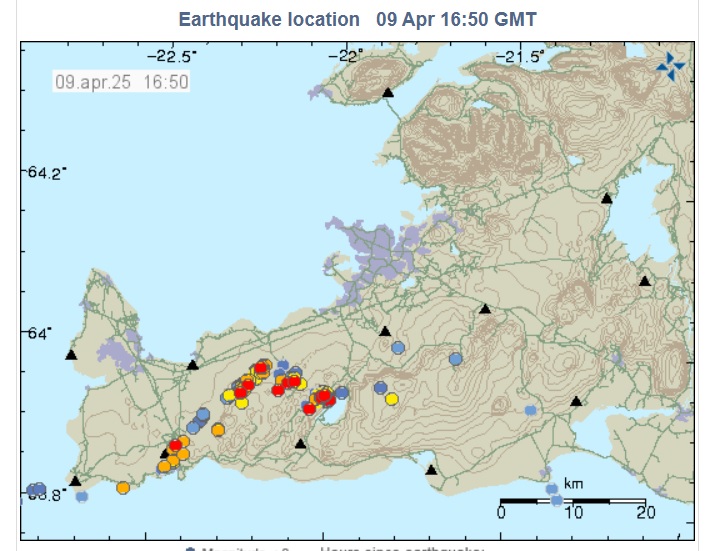
Source: browser.dataspace.copernicus.eu. Captured February 20 2025. SWIR image showing the new lava lake, shield pahoehoe tube feed flows and active lava tubes feeding pahoehoe flows downhill. The new summit lava lake was around 400 meters long

2025 thermal data giving the size of the new lava lake. The brighter areas are lava fountains and upwellings.

Captured at March 20 2025, showing the filled caldera and the new lava lake.
The large open circulating lava lake present at Nyamuragira summit shows that the volcano has entered a new eruption cycle of open conduit summit-centered activity. The last time the volcano was like this was back in the 1930’s. To say the truth: it is better to call this a shift in eruptive behaviour rather than a shift in an eruption cycle. A lot what Nyamuragira does is random and has no timetable or exact forecasting, even if high standing lava lake columns in Nyiragongo and Nyamuragira can be correctly forecasted to lead to collapse and drain out in the rifts. Lava lakes being exposed deep magma columns are long lived and this one could last decades. But with the lava column building itself higher and heavier through ”shielding” a drain-out into the rift systems is a serious possibility quite soon.
I became suspicious that there was a large open active lava lake present in the summit of Nyamuragira as early as January 2024. I clearly remember photos on social media, especially one seen from Goma at night showing a huge glowing red pyrocumulus column rising from a yellow base at the caldera. Such condensation columns are pretty much always present in both Nyiragongo and Nyamuragira, two glowing columns, but the condensation column over Nyamuragira is by far the strongest and densest these days. It makes sense that it was an open magma column that is convecting and degassing itself. For the Goma residents it must be a terrifying sight for many, the night skies ( that are nearly always cloudy ) due to lava lakes’ illumination of the clouds have nearly always a sickly twisted red color. Remote monitoring from space was hard for weeks due to the equatorial cloudiness but I remember thermal shots from space showing an intense thermal source from the NE pit sitting right below the condensation plume. It was much bigger than any other open lava lake thermal signature that I seen earlier in SWIR instrument images. The thermal area was at least 400 meters wide so it was sizable indeed compared to other convective lava lakes. I struggled for a long long time with satellite tools getting a clear shot in the caldera. In the deep tropics clouds are pretty much ever present and they mixes with the steam column from the lava lake making it hard with monitoring.
I really wanted clear weather shots of the NE pit but the tropical humidity turned out to be annoying and it was hard to find clear shots from space. My luck came true on 21 February 2025 when using Copernicus space imagery from the Sentinel Playground, a clear day offered a good shot on the NE pit that indeed had become one huge lava lake. I was quite surprised by what I saw. The whole NE pit was filled by a convective open lava lake. I used the measurement tool and got almost 400 meters wide! That is nearly twice the diameter of Kilauea’s old summit lava lake as it was in 2015. More clear imagery came on 21 March 2025 showing the lava lake to still be there. The SWIR thermal instrument showed a very strong persistent thermal signature 380 m long at the same spot. Lava lakes are not common on Earth. During this type of activity magma circulates constantly between the surface and the deep magma system, as hot fresh incoming magma rises and cooler degassed magma sinks back into the conduit.
A lava lake acts very much like a lava lamp with its convective currents. A massive heat influx and constant supply is needed to keep the whole thing running and to keep it from solidifying. This explains why lava lakes are so rare on Earth. The whole buried floor of NE pit may have simply collapsed into the magma chamber itself that is now visible at the surface as a lava lake. It is a rare phenomenon having a circulating magma system open to the surface. At 350 – 400 meters wide it is at the current time the world’s largest open conduit lava lake. It is much larger than the small lava ponds in Yasur and Masaya. A lava lake’s size may be correlated with the strength of the magmatic influx. Nyamuragira and Kilauea have the highest magmatic influxes on the planet as individual volcanoes and together with Nyiragongo tend to form the largest lava lakes. Kilauea is stronger, which is why I imagine Kilauea may be able to far exceed Nyamuragiras new lake in size in the near future. But by these days ( at writing ) this is the world’s largest circulating lava lake.
Nyamuragira’s new lava lake is roughly bean shaped with rising lava apparently welling up in the southern part of the lake and sinking down back in into the conduit in the northern part of the lava lake as a part of its natural convection cycle. The scale of lava lake activity is quite impressive, I measured the glowing parts in the lake at different dates at 130 meters wide for many spattering upwelling and downwelling regions. The specs were especially impressive for 20 February 2025 showing a glowing red surface in visible light over 200 meters wide! The lava lake must have had a very fast surface flow to allow it to glow like that because lava cools very quickly on the surface forming an insulating skin that otherwise restricts a high thermal flux. Between them there is a calmer region where a thin crustal “scum” can form. Lava lakes tends to have a violent formation and they tend to calm down when they grow larger and the system degasses. It will be very interesting to see just how large this lava lake will be able to grow before it gets too heavy and drains out. This very vigorous convective activity is driven a lot by rising gases that come from way below Earths crust. Sulfur dioxide emissions have been especially vigorous from Virunga recently. Near the crater rim, underneath the volcanic plume rising from the lake, the rain that sometimes condenses out from the plumes from both volcanoes can have pH as low as 2. Low pH values and high fluoride contents has been measured as far as the village of Rusayo, 10 km from the summit (sourced from Albert’s information on local acid problems).
As already told the scale of lava lakes surface activity is quite impressive and it looks and behaves very different from other past large lava lakes in Kilauea and Erta Ale that are typically more placid in surface behaviour. This lava lake is nearly raging, at least near the edges. Highly potassic volcanoes like Nyamuragira and Nyiragongo have a lava chemistry and gas ratio content that differs from normal basaltic volcanoes so gives both lava fountains and lava lakes a distinct look. The gas rich nature of the magma from water and carbon dioxide may be the cause of the spectacular surface lake activity, combined perhaps with an increase in magma supply. Alkaline magmas tends to be gassier than sub-alkaline ones perhaps explaining why Nyiragoingo and Nyamuragira have more active lava lake surfaces than Erta Ale and Kilauea. That said, because of Kilauea’s massive supply at moment and very high sulfur gas content it may too be able to form a similar lava lake in the coming years and it maybe able to grow much larger than this.
Lava lake activity continues non stop at Nyamuragira and it appears ( seen from space ) that between February and January 2025 there may have been a slight decrease in lava lake levels. It does not mean that the lake is about to disappear. It has not been as high since it formed in 2012 – 2015. The magma column may have degassed itself a bit and the lava sunk a little. Lava lake surface activity ( degassing ) anyway remains incredibly strong compared to pretty much any other open lava lake that I have been studying in videos and space imagery. This is the most violent really large lava lake that I ever seen.
I hope that OVG goes up to this lava lake by helicopter very soon to take lava samples and gas samples that can be compared with earlier Nyamuragira eruptives. As with Nyiragoingo, Nyamuragiras magma chamber morphology is poorly known. The presence of a caldera is of course a strong indication of a shallow chamber. The geologist Hamaguchi (1983) found an aseismic zone between 3 and 7 km beneath the 1981-1982 eruption site, suggesting that these signs were indicative of a magma reservoir at this depth range. Other geophysical modelling of ground deformation through InSAR suggests a shallow magma reservoir sitting at a depth range of 2-4 km. The current lava lake pipe is connected to this system and new samples could be useful to track changes in the central magma system related to magma supply and magma storage. A convective lava lake is a manifestation of the very deep magma system that goes all way down into the asthenosphere, something that is rare indeed. I guess that we will get fresh direct footage quite soon.
The emergence of such a large lava lake at Nyamuragira summit gives extra potential hazards which the population at Goma that are dodging disasters all the time have to live with. The nearby villages are put at risk as well. The rising magma into the summit could end up feeding a large flank eruption. Nyamuragira and Nyiragoingo are prone to catastrophic drain-outs if their magma columns get too tall. This is a very likely scenario if Nyamuragira’s lava lake keeps getting taller and making itself a shield around it, which will increase pressure around the magma column. I assume that a lava lake column this large will put more pressure around it then a more narrow magma column would do. A small weakness along the volcano’s base could allow the magma to come rushing out through the side like it did at Nyiragongo in 1977, 2002 and 2021. A large drain-out has terrifying eruption rates with many thousands of cubic meters of lava a second. This is a serious risk for smaller isolated villages that are close to the volcano. Goma’s center, due to geography, is fairly safe from large lava flows emitted from Nyamuragira but Goma’s sub towns towards the west are at risk from being buried by future lava flows. Large lava flows have flowed there before in the early 1900’s where they entered Kivu lake.
The largest fear from the locals is a large intrusion down under lake Kivu that sets up an underwater eruption in the lake floor and stirrs up this volatile lake. Experts estimates that there is 72 cubic miles (300 cubic kilometers) of CO2 and 14 cubic miles (60 cubic km) of methane sitting at the bottom of Lake Kivu, and it can be stirred up by a lake eruption. That said, it is an extreme scenario that is not very likely on a human timescale.
It will be interesting to see how long this particularly large lava lake will survive before it drains out. A drain-out will likely happen in one of the two rifts where zones of structural weakness are.

Photo 2025: sur vos stars congolaises: Nyiragoingo ( to the right ) and Nyamuragira ( to the left ) co– rupting. Nyiragoingo really looks like Mount Doom here I can almost see the nazgul riders on their fell beasts, circling the volcano guarding the peak.

Photo: Michel Lunanga late 2024. The steam plume from Nyiragoingo that is co-erupting with Nyamuragira.

Sentinel images from 2025 :the summit caldera with the new lava lake and pahoehoe overflows to left.

Photo: Michel Lunanga late 2024 the steam plume from the new lava lake.

Photo: http://eventsrdc.com/ 2025

Photograph: Taken in 2023 OVG a lava tube feed by the summit lava lake. This tephritic pahoehoe lava looks just like Hawaii basalt.
Jesper Sandberg March 2025
Source links: GVP, volcanodiscovery and various including social media and https://browser.dataspace.copernicus.eu/?dateMode=MOSAIC is a very good site to remote monitor volcanoes.


A new article is up! thats right.. splaaaaaash!!! bulb blub blub and Gollum is gone. The lava in Congo and Hawaii is so very fluid that it may really behave like this if you fell into it from great height with forceful impact, you woud penerate and sink down deeply despite the high density of the lava ..
This is a bit tasteless though, your phantasy gallops too far with you. Nobody really goes to Congo at the moment, anyway and in Hawaii they do keep people at a distance when necessary.
The infamous scene from 2003 The Lord of the Rings: The Return of the King the Gollums fall into the lava scene was an impressive all cgi work and took many hours to render. The other lava scenes where mostly matte paintings and the famous cellulouse gunk with food colouring that they had lit with UV from underside on a miniatyre of Mount Dooms slopes, same gunk stuff where used in the Mustafar scenes in Revenge Of The Sith
Oh. I never watch that kind of stuff.
Gollum contains a fair ammount of water so he woud not burn instantly on contact with the lava, althrough he will “decompose” into flammable gases very quickly once he is submerged in souch a hot and dense enviroment. Most other lavas in the world ( not Hawaii and Congo ) are so viscous near the vents that if you fell into them you woud break all your bones rather than sinking into it…
Falling into any liquid from that high would feel like hitting a solid surface really. The surface layers of lava lakes might be more foamy though, so actually you might sink through. I remember reading once that the old lava lake at Kilauea was less dense than water in its surface layers. I would imagine Nyiragongo and Nyamuragira are the same or maybe even more so with how their magma is probably more volatile rich.
Theres a video of throwing a trash bag into a lava lake, I think at Erta Ale, and it goes right through before the puncture in the crust turns into a vigorous spatter source. A bit grim but thats probably the same as what Gollum would have done. I doubt you would be alive long enough to experience any sensation of the lava, either radiant heat or the impact would be it.
Also maybe the obvious problem but gold wont melt in the lava, especially sitting on the surface crust. It would probably sink immediately if the crust broke though, depending on densuty vs surface tension, and I dont know if it might be able to melt deeper down.
Thats assuming the ring is actually gold though, being so precious it could be something else. If its iridium plated with gold its going to be basically indestructible 🙂
Nevermind that last bit, apparently the one ring is actually officially made of real life gold, nothing fantastical or made up. In which case its a bit of a mystery how is survived unscathed up to its destruction… I guess that must just be a magic element to it then.
Interesting piece, Jesper, well written, enjoyed, thank you.
Youngster:
Very much endangered by habitat loss, poaching (also for bush meat – I consider that a subform of cannibalism), disease and war and civil unrest:
https://en.wikipedia.org/wiki/Mountain_gorilla
Park rangers are sometimes killed.
Brother and sister
Depiction of the Nyiragongo and Nyamuragira volcanoes, based on data from the Shuttle Radar Topography Mission and Landsat. Vertical scale exaggerated (1.5x). fr.wikimedia
might not show up, one last try
one more try>
2002 had a flank vent open up right side Goma airport sending a fast moving lava stream straight through the inner city a small lava flow but catastrophic in souch a densely populated area
Does the cone at the foot of Nyiragongo have a name, is it a new edifice building?
Thats Sharehu crater a cone formed on the same fissure line as Nyiragongo as well is Baruta on the other side of the volcano edifice, I think only Nyiragongo is active today while the other two are now likley extinct even if they are frequently intruded by magma from the main cone itself. Nyiragongo likley grew as a series of giant fountain feed Puu Oo s tephra complex with the middle cone now having matured and evolved into a true polygenetic central volcano, overtopping its parasitic compeditors
Great article Jesper. I told you once how much I liked these volcanoes! Fascinating, albeit, too dangerous to the people around. Congrats!
We’ve got dire wolves. I suppose?
https://www.cnn.com/2025/04/07/science/dire-wolf-de-extinction-cloning-colossal/index.html
More like 0.1% dire wolf.
What are you saying Chad? 0.1%>100%
Interesting article, Jesper. If I can add two volcanoes which should be watched, one is Tofua at 19°42’28.8″S 175°04’08.4″W whose lava pond is visible to the NASA Firms satellite and a very interesting volcano named Tinakula, at 10°21’21.6″S 165°47’09.6″E in the Solomon Islands which has the habit of erupting pyroclastic flows and wiping out all life on the island, including the humans there too, at least in 1840 or so. It has popped up often on the NASA Firms satellite also and is noticeable.
(V2Cam, Live)
Odd, Episode 17 might have begun. Earlier than expected.
Another odd thing to note, only the south vent is active. Seems the north vent is shut down this time.
Its pretty weak still, it might be the early build up that the north vent previously did, so could be a day or more before high fountaining. It is notable the north vent isnt even glowing though, and it didnt really fountain last time either, it could be blocked. Although its possible it will still stay active and erupt again in future episodes.
If there is only a single vent now, it could mean we see even bigger fountains. Some bursts in E16 got tantalizingly close to the 500 meter mark, even though sustained heights topped out at about 300 meters. All of the open conduit vents on Kilauea have reached 500 meters, except the 2018 summit vent which didnt fountain. The amount of degassing this week to me shows that this magma is fresh and full of volatiles, and is increasingly more primitive rather than stuff left from before 2018. Its never certain but I think there is a good chance the 1959 record will be broken this year.
Is the eruption actually on the southern vent or have the twin vents united to an one and only one? S2 cam looks as if the two vents grew togehter yesterday
Is it now the expected time for the twin cones to unite to a single cone? If so, we get an interesting quasi-experiment soon that shows whether the united cones erupt stronger together than when they were seperated previously.
It is the south vent, no merger evidet
Actually its picking up faster than the last few episodes, it could go full power within a few hours at this rate. Lots of spattering now, nearly a true fountain.
The lava has actually flowed pretty far already and with decent output, while the fountain is still barely visible above the rim of the cone on the V2 cam. This is probably all degassed lava from the past week of intense fuming, which I only assume must have been partly weather related somehow as it was very thick.
If this is just degassed lava being pushed out then the fountain might shoot up to a great height very suddenly. The biggest fountain in 1959 went from 10 to nearly 600 meters in about a minute if I remember correctly 🙂
Mama Loa is watching the child play:
https://www.youtube.com/live/oG5zz9Sjw3E?si=kCJm9q37IDqNXwjM
Looks like north vent is getting more active (pulsating glow in there).
The north vent does again more slow growing activity as during the previous episodes. The south vent is at a much more larger scale active than we saw during the inflation phases of previous episodes. Maybe the south vent is going to be the dominant vent for the whole eruption.
Deflation has started, so the spectacular part of the episode with lava fountains should start soon:
Wrong image, I wanted the short-term deformation diagramme:
Nyiramuragira is one of the most hawaiian volcanoes outside Hawaii. Thank-you Jesper for this fantastic introduction to this central African volcano!
These and Ethiopia’s volcanoes (f.e. Erta Ale) show, that the breakup of a continent and the origin of a divergent plate boundary has some similarity with big active Plume hotspots. In both cases something hot comes up in the mantle (like in a Lava Lamp) from the Core and diverges below the earthcrust. Plumes are punctual divergent zones, while divergent plate boundaries are long, divergent zones. Oceanic divergent plate boundaries usually have nearly the same magmas like Hawaii, Reunion and Iceland. It appears to me that the continental birth of a plate boundary has alkali magmas that later change towards normal oceanic basaltic magmas. Failed rifts, that died before the creation of an oceanic divergent plate boundary, produced alkali magmas as well as the Congo/Rwanda volcanoes.
Do we know why and how the parental magmas of alkali magmas (like these of Nyiramuragira) originate?
In Hawaii the older volcanoes have more alkaline magma, and the earliest eruptions are too. It was always explained as being because of the depth of melting. Deeper melting is where there is more pressure so a smaller fraction can melt, meaning only very hot or exotic compositions can melt deep down. Continental crust is thick so the bottom of the lithosphere is deep by default, I assume this is why eruptions start alkaline. But it might also just be local mantle is enriched, like seems to be the case in Italy.
Really, all ‘alkaline magma’ means is that it has higher levels of Na/K compared to oceanic basalt. But most alkaline magmas are enriched in most trace elements, so its a bit misleading. Nyiragongo erupts nephelinite which is probably the most exotic silicate magma of any active volcano observed erupting, its lava is as different from basalt as basslt is from rhyolite, in terms of SiO2 content. Nyamuragira is basanite which is the most mafic of the wide range of rocks called ‘alkali basalt’, same as on La Palma in 2021ɓ
How do alkali eliments come into magma at this depth? Does the mantle contain more alkali than the fluid magmatic parts of the earthcrust? A real mantle magma on the surface of Moho or inside a Plume Head is probably very different to earthcrust magma.
I dont know exactly, but its probably because Na/K dont stay in silicate minerals as easily so will mobilise more easily. Both can only form 1 bond, so they cant form polymerized oxides like Si, Ti, Fe and Al, and the charge isnt as strong as with Ca and Mg. Cl and F also only form 1 bond but can escape by forming HCl/HF, but Na/K dont have any volatile compounds.
If you freeze saltwater the ice is mostly fresh and the water still left will be salty. Thats also how magma evolution happens, but I think maybe alkaline magma forms in the reverse way, with the exotic elements melting out first and the bulk rock forming elements belting into it until eventually it is almost all melted (ultramafic).
Thats just a guess.
Foiditic magmas are probably very hard to find many conclusions about in general about given how rare they are with to my knowledge Nyiragongo and Ol Doinyo Lengai being the only active ones producing them and available to study and maybe a handful of monogenetic volcanic fields.
Not much to say except they seem to only be found in continental rifts.
Low fountaining has started
still going https://www.youtube.com/watch?v=fiyttmA7YkA, and the lava is flowing quite fast https://www.youtube.com/watch?v=oG5zz9Sjw3E – didn’t realise it was that fluid
Lava flows in E16 were fountain fallout so probably cooled off a lot falling back. There isnt really any of that now, the fountain is low but very high output. I am guessing it is very degassed lava after the last week of intense fuming. Although I thought it would have gotten higher by now.
But yes Kilaueas lava is very low viscosity, I have seen it said to be as low as olive pil or ketchup, I cant remember where but unlike a lot of lava it is unambiguously a free flowing true liquid. It is fluid enough to preserve details of trees and fruit it buries, meaning it can seep into gaps in the bark… Summit eruptions at Kilauea also might be the hottest of all volcanoes, which helps.
Hi guys,
What do you think about flying in to watch the Kilauea eruption tonight?
It’s almost 2pm HST I can probably be up at the volcano at sunset if I get moving in the next hour… Two short flights and a drive.
Do you think the de-gassed lava is about used up and the real fountaining will begin soon or is it a dud and will only do low fountaining this episode??
Of course nobody knows but I need to make the call soon…
Thanks!!
Update: TLDR I’m not going this time – the planets wouldn’t line up for me unfortunately.
It does look like the fountaining is getting more vigorous approaching 3pm HST.
No big fountains still, maybe not this time. But there is a long channelized flow going into the east end of Halemaumau after spilling from the lava lake in front of the cones. Without high fountains the lava stays fluid instead of turning to a’a nearly immediately.
The flow is very vigorous. Fountains less so. I think the lava level is a bit higher than before, making the cone into a larger lava pond. That will reduce the height of a fountain
It is getting a bit taller now, not like last week but maybe up to 100 meters in bursts. The flow rate is probably lower than last time too based on deflation rate but its all going into that channel so its all visible.
Pu’u O’o did something like this I think. Up to mid 1984 it was an enclosed spatter cone with generally pretty mild fountain intensity, so its lava stayed as pahoehoe and flowed very fast very far, as much as 14 km in a day. Afterwatrs it had a slow buildup to one episode that filled in the crater and changed vent geometry, and without a pond to blast through fou tains got huge and flows got shorter because they were fountain fallout not a pond overflow, more viscous and more spread out flow.
But I think the intense degassing before E17 probably has a part in the low fountain height too. If there is no such activity afterwards, then E18 could be huge again. Will be a good testable hypothesis.
Indeed, the altitude of the lava shield is rising at the peak (surrounding the cone). With it the altitude of the lava flows rise which leave the cone. So the lava fountain in the crater has the challenge to grow with the lava shield and lava flow, and to overcome the weight of the magma/lava in the crater.
Are future episodes going to erupt without a lava fountain? I imagine a calm lava table rising above the crater rim like a sea tide without significant lava fountains.
I would assume future activity might at some point become continuous, but that doesnt necessarily mean fountaining stops altogether. Pu’u O’o stopped fountaining because its continuous eruptions were from flank vents, it wasnt until 2013 that a flow fed from a vent inside the actual crater became the main flow and it only lasted a year. But if the eruption now became continuous it would either be a flank vent way outside the caldera near Mauna Iki, which is unlikely, or it would be the vent itself flowing continuously inside Halemaumau. As long as the vent stays narrow it can return to high fountaining and episodic eruptions at any point.
I feel like, the fact both Mauna Ulu and Pu’u O’o only became continuously active by conduit failure and satellite vents, might be a reason to believe it is actually pretty hard to have a fountaining vent just stop. Holuhraun was fountaining to hundreds of meters high for a month without stopping and only after that did the vents start to erode enough to become more passive. Kilauea in 1960 had fountains as big as the E16 fountains for over a month too and even had a vent failure, which only spawned 2 more high fountains… It never slowed dkwn until it actually stopped. In 2018 fountains werent that tall to begin with, and the two vents inside Ahu’aila’au had much higher output than single vebts in the other eruptions, but even there it took weeks to have fountaining subside below the cone rim. In its eruption now Kilauea so far hasnt had anywhere near that long actually erupting in total and most of its last 4 months the vent area is cooling down between episodes. There may be intervals of continuous eruption but it would still pause and fountain too. If there is an intrusion and eruption somewhere else though and the vent collapses into a pit crater then that is where passive slow activity could take over. But key word is still could, not will.
Basically its not a neat linear progression.
With each episode the peak of the lava shield grows, on which the crater sits which hosts the lava pond and fountain. Fagradalsfjall I 2021 had a similar development. The eruption began in the valley, and with every lava layer the craters climbed higher and higher.
The higher the lava shield grows, the more gravity force has rising magma to overcome. 2021 we saw how many craters of Fagradalsfjall waned to erupt, when they reached a certain high, as if there was an invisible glas ceiling. Does Kilauea currently also has such a glas ceiling for the potential growth of its erupting cone?
I imagine that once the shield has grown enough, there might develop some kind of side events or lava tubes that flow through the caldera. Fagradalsfjall I did this when lava ran all the way from the central cone to Natthagi Valley through lava tubes. Has the caldera ever done lava tubes?
Kilauea has overflowed its summit before so I doubt it has a magma pressure limit. The plume easily pushes magma another 3 km higher at Mauna Loa. The actual limit is if it is easier to push that magma into the rift zones than fill up the caldera, and for the past 500 years that has been true. But for most or all of the time between about 900 AD and 1500 AD it seems like it was easier to erupt out of the summit and fill in the caldera, than it was to erupt on the rift zones.
The question is if that tipping point has been passed. The ERZ erupted less than a year ago so it might be foolish to say its actually dead, but it is totally silent and shows no signs of any magma supply. All the magma right now is erupting, its very nearly at 100% eruption rate, quite literally an open hole into the mantle. Pressure will increase but the pressure in the magma chamber now is actually higher than it was last September before the Napau eruption, yet no magma is leaving the summit.
My guess, an open hole is way easier to erupt from than breaking rocks even if gravity favors it. As long as that hole is open the vents probably have to be MUCH higher up to put the same pressure on the magma system as a closed roof.
So no, pressure is unlikely to slow this eruption at all.
I’m also thinking about whether Kilauea’s summit once develops a crack towards SWRZ, when the lava shield has risen too much. The magma inflow rate is very high now. If the summit gets a problem to continue the eruption vertically, it may choose a horizontal exit like 1919. Maybe the 1823 SWRZ eruption had a similar development, but I don’t know much about it. https://www.usgs.gov/observatories/hvo/news/volcano-watch-most-unusual-kilauea-eruptionmaybe-1823#:~:text=The%20eruption%20was%20over%20by,too%20hot%20to%20walk%20on.
It looks as if Episode 17 is going to be a minor one. The inflation peak was at a relatively low level like Episode 14. Deflation will probably hit the bottom soon, when the episode ends. I’ve noticed that the deflation is less steep than during previous episodes. This explains why the eruption lasts relatively long. It erupts steadily on a moderate level. If a major episode does it like this, the eruption is able to last for days. Episodes 3 and 4 have been the longest until now with 8.5 resp. 3 days. Maybe future episodes grow longer.
It’s dead, Jim.
Yes, not as intense as the last few but the volume is pretty normal, E16 was particularly big I think only E3 was bigger but that was the main deflation of the summit. 10 microradians is maybe 5 million m3 of lava erupted.
The last map was made between E13 and E14, and there was 65.5 million m3 of lava erupted in this eruption at that point. Since then, E14-17 have a combined 39 microrads of deflation, which might be 19-20 million m3 of lava. So the total is probably about 85 million m3 of lava now. At current rates of 1-2 microrads a day recovery, or about 750 thousand m3 a day, it will take about 750 days to overflow the 2018 caldera. So in the second week of January 2027 🙂
At that point too, unless it fills as a flat surface, the vent and cone will probably be taller than the southwest caldera rim to get the gradient to flow over the north rim of the 2018 caldera. So it could even flow out of the caldera that early. By 2030 another 0.8 km3 of lava sits on top of all that again. Its definitely overflowing somewhere, Pele is putting on a show for us now 🙂
2027 – 2030 is the stuff Im waiting for its kind of a disgrace that I may never be able to visit Hawaii for years years years due to Im very busy and having alot to do, here in the worlds richest countries there is very
little free time sadely when you gets adult
It is death, but not as we know it
Both episodes 16 & 17 have expanded the eruption time to around 1,5 days (~36 hours). Since Mid January they were the longest lasting eruptions. On a photo in the new multimedia update HVO shows how the lava field expands towards the east: “a small lobe of pāhoehoe breaks out at the far eastern end of the crater.” https://www.usgs.gov/observatories/hvo/news/photo-video-chronology-april-9-2025-more-views-kilauea-episode-17
This new map shows that the lava shield/field has covered 90-95% of the down-dropped block. On the east side is now kind of a flat “lava beach”, were the lava expands with each episode a bit more:
 ?itok=T9z777bh
Thank you for the fascinating read, Jesper!
This fast-running lava of Nyaragongo must have a reason.
There is also fast-running lava at famous Ol Doinyo Lengai, but a different chemical composition, Natrocarbonatite.
To look for a reason I also stumbled upon the clockwise!!! rotation of the Victoria Microplate, mostly underlain by the Tanzania Craton, Nyragongo beign west of it, El Doinyo north/east.
This rotating plate/craton must create surplus heat and fraction and seems to be a unique neighbour to a spreading ridge which was split up in several parts by that plate/craton. Whether this partly explains the unusual lavas remains to be seen.
I am as usual much infatuated with my theory, but this special love is unique for geologists and also hobby-geologists alike and drives ideas.
https://www.nature.com/articles/s41467-020-16176-x/figures/1
Nyiragongo has Foidite magma. It is Africa’s Vesvius … but on an divergent plate boundary, while Vesuvius is on a subduction zone. Vesuvius like Nyiragongo has both explosive and liquid magma. A difference is that Vesuvius also evolves the alkali magma towards Phonolite (~Alkali Rhyolite) that did the original Plinian eruption 79. 1944 Vesuvius was both explosive (~Vulcanian) and effusive with fast running lava that remind to Nyiragongo’s dangerous lava eruption (f.e. 2002 Goma).
“Nyiragongo is the record holder for the lowest silica magmas among active silicate volcanoes.”
https://www.volcanocafe.org/nyiragongo-and-its-ultra-alkaline-magma-part-iv/
It is not comparable with Vesuvius as unique.It is Nephelenite, a rare petrochemistry.
Vesuvios parent magmas are likey basanites so they are are not as Sio2 depleted as Nyiragongos nephelinites thats a step lower still in sillica depletion and alkalic enrichment. Nyiramuragira is very similar to some of the less evolved Vesuvio magmas I think souch a tephrites while Nyiragongo is more sillica and alkalic enriched further still
Nyiragongo is more sillica depleted and alkalic enriched further still ( corrected )
It is in a way very simple to imagine this as the distance between Mount Vesuvius and Pompeii is about the same as between Mount Nyaragongo and Goma.
Lava from Nyaragongo mostly reaches Goma, first the airport, whereas lava from Vesuvius is said to not have reached Pompeii in 79 AD. People died from hot ashes, rocks and pyroclastic flows.
Further south at the southern end of the craton/plate we have three volcanoes, of which Rungwe does lava flows and Plinians, Ngozi does only explosive eruptions and Kyejo does lava flows. So far I have no info of the petrochemistry, and the area seems a little underresearched, so wonder.
One thing is clear though: All the volcanoes in those latitudes are bordering the Victoria Microplate/Tanzania Craton in their middle. So, this is sort of one unit.
https://www.volcanocafe.org/rungwe/
Correction: Counterclockwise!!!
Africas magmatic strangeness haves alot to do with its a very thick continent thats splitting up, the magmas gets enriched in all kinds of elements on the way up. As chad saied earlier the partial melting in Africas litosphere is very deep down indeed and in Kenya where Lengai is thats close to a craton edge its perhaps even deeper down than in Virunga even if thats very deep too. The very high pressure and high temperatures makes minerals chemistry melting in Virunga, Kenya and Tanzania very otherwordly compared to say a normal shallower astenosphere at a mid ocean ridge or a powerful thoelitic hotspot. The deep magmas in these African areas are likey very hot since melting occurs so very deeply but its a long way up too for them to rise up to the surface and that means that neither Virunga or Lengai areas will be very hot compared to most other hot basaltic magmas. Nyiragongos magmas are likey much much cooler than both Hawaii and Iceland due to the very long way they have to rise and they dont look as bright at all in daylight, thats saied I have seen some videos of Nyiragongos lavas that looks quite bright in daylight but most videos looks a bit cooler than Hawaii. The hottest African magmas maybe Erta Ale that looks more like Iceland and Hawaii basalt Afars litosphere is thinner makes the heat being closer to the ground
Nyiragongo while is very deep crust is maybe likey a too shallow litosphere to produce a carbonatite melt of its co2 gas. Ol Lengai sits on an even deeper litosphere as well does many of the other ultra strange African carbonatite – foidolitic monogenetic fields
Did the Madagascar/India divorce 90 mio years ago happen with the eruption of alkali magmas like the present African Rift Valley in Rwanda and Congo? During this divorce the Mascarene-Plateau traps were built by flood basalt.
Maybe the current East African alkali magma volcanism precedes a future flood basalt eruption like the Mascarene Plateau or the Deccan traps.
Reykjanes shows a nice line up of quakes; three rift lines on show.
Its kind of concerning that the uplift at Svartsengi is so fast while the last intrusion isnt silent yet. Its on track to erupt in late April or some time in May, and it could just push up north again but no need to fill any space it would flood out… That would also be the first time in 800 years that Iceland has an ocean entry on the main island.
If it carries on with the same trajectory, it is inflating at the same rate as after the first intrusion in November 2023. It was 37 days to the first eruption, then 24 days with a similar inflation rate.
One thing that’s different this time is that the eruption was very short lived. In previous events, magma has continued to flow to the surface for days or weeks after the emptying of the Svartsengi sill. It’s possible that the fast supply rate has been there also for previous events, but it has not been obvious in the GPS data, since much of it went to the surface instead of accumulating in the sill.
There are already signs in the GPS data that the supply is slowing down again. It will be interesting to see in one or two weeks from now if it’s still faster than before, or if it returns to the general trend of slowing down.
I said the same thing last week, that the decompression of the first stage might be erupting instead of reinflating the sill. Or was before.
But its still pretty clear this isnt over yet too, any suggestions of this being the last eruption are premature I think.
This episode resembled the Krafla volcanic-tectonic events 1975-1980 that happened predominantly intrusive with only minor/rare eruptions: https://nat.is/krafla-fires/
I’d assume that Krafla has more space for intrusions. It is a real volcano with a central caldera etc. contrary to the Reykjanes volcanic systems. So Krafla could probably bear more intrusions without eruptions than Svartsengi can do.
Svartsengi has had until now 8 eruptions and (if I remember correctly) two intrusive events (November 2023 and early March 2024). The 18 months Svartsengi GPS graph shows both intrusions with a blue vertical line: http://brunnur.vedur.is/gps/reykjanes.html
Both intrusions were accompanied with a very steep inflation. Similar to the steep inflation after the April 2025 intrusion. Our event is predominantly an intrusion with a minor eruption like Krafla 1975.
The more I read about different geological models and processes, the more complicated the picture becomes. After large seismic events, there are several different sources for post-seismic deformation.
Short term (days to weeks), there’s poroelastic deformation: The crust is porous and contains ground water. Seismic events induce changes in the pore pressure – this is why the levels in the Svartsengi wells rapidly change and act as sure indicators for every new dyke intrusion. After each event, fluid diffusion will strive to relax the changes from the seismic event and this can be seen in ground deformations.
Long term (months and years), there’s viscoelastic deformation, caused by elastic energy from a large seismic event being temporarily stored in the viscoelastic layer below the brittle crust and then slowly released over time.
Then there’s decompression melt that brings up new magma. Then magma storage itself can be a mush that is also best modeled using poroelastic models with a poroelastic response to injection/withdrawal events.
All of the mentioned processes cause deformations that gradually decrease over time and can be observed as ground deformations in GPS measurements. Throw in the long term plate tectonics, with an oblique transform fault, into the mix, add the Icelandic hotspot, give it a good stir and then try to figure out how everything fits together. Every time I think I’ve got it, something new pops up.
One thing is for sure, and that is that it’s not enough to look at the up/down component of a single GPS station. I think the best thing to look at right now is IMO’s estimated volume changes in the Svartsengi sill. It tries to isolate the vertical and horizontal components caused by the volume changes. It probably has quite a large margin of error, but it’s the best we can do, and it clearly shows that the volume is increasing. Unfortunately, I don’t know if there’s a live updating version somewhere, so we have to patiently wait until they include it in their updates.
On Shaun Willset’s latest update he found a paper on the Svartsengi eruption series. It shows, among other things, how the centre of greatest inflation has moved around. Of course, that could be due to margins of error or ongoing changes (or both).
IMOs figure on the inflation show that most of the image.nflation episodes decreased in a sort of hyperbolic curve, but it was more obvious in the first few.
Fagradalsfjall 2021-2023 showed a clear S to N migration of the eruptions over time. The first was in the south, the second migrated a few kilometers to north, the third continued this movement.
The April 2025 dyke was a comparable migration of the main activity to the north. 2024 was a series predominantly on the southern part of the fissure, while the next episodes may occur on the northern part. There the location is very human friendly and won’t do any costs.
The earthquakes today are exactly in the area, where prehistorical Svartsengi eruptions happened. It is 2-3 km north of Fagradals-Hagafall. There is a small exclave of Svartsengi’s lavas inside a big region of Fagradalsfjall’s prehistorical lavas.
It’s probably the general area for the end of the extended dike.
Yes, if I look on the lava layers map, the prehistorical eruption there was probably as big as the Grindavik eruption on April 1st. It is a possible exotic location, but only does small eruptions.
https://i0.wp.com/www.volcanocafe.org/wp-content/uploads/2025/03/word-image-17447-12.jpeg?ssl=1
Souch a nice shot really look at Nyiragongo so threating it looks lurking in its own condensation clouds. I can almost see the ringwraiths on their fell beasts circles round round around the peak constantly, constantly circling around, slaves to the demonic powers of Mount Doom and the Ring
I believe the picture for the headline of this article is the Gunung Ibu Volcano, so here’s the night time pyrotechnics done by Martin Rietze https://www.youtube.com/watch?v=qMkfT1e4HQQ The occasional volcano lightning is interesting.(say 2 min 25 secs into video)
Why do you believe it be Gunung Ibu? Gunung Ibu on Halmahera Island, Indonesia, has only villages around. Here you can see a city in front which would be Goma.
This being said I have to add that the night flim of Gunung Ibu is beautiful.
Denaliwatch, you are probably correct. Thanks for the comment.
https://www.windy.com/sv/-SO2-tcso2?tcso2,-0.989,25.972,5
The So2 plume from Virunga is still totaly massive looks like this is a constant behaviour for now
Magma accumulating quickly now in Svartsengi again perhaps its sucked up into the sill and dyke system like a straw due to underpressure like a peunomic mail vaccum tube. These animations where my funny reaction due to the start of the rift episodes in Reykjanes in 2021 fun because it maybe decades even lifetimes of upcomming eruptions on the penninsula
The intrusion clearly intersects the lava shield “Thrainsskaldarhraun” of Fagradalsfjall. It is only three kilometers away from Keilir!
If in future Fagradalsfjall erupts again and bigger than before in the Keilir area, we lava flows of both volcanic systems can get very close to each other. It’s like if lavas from Mauna Loa and Kilauea meet on their border.
(B2 Cam, live)
This is quite interesting. After the eruption ended, parts of the caldera rose up. It is obvious it is lava under the crust, but it is just interesting to see it in action. I wonder if this will become some kind of magma chamber or if it’s too shallow to be considered one.
This photo shows the progession of lava on the east shore of the lava flood field. It also shows the erupting vent in the background:
It is probably too shallow to be considered. Lava is also not getting in from below but from above now, the lava from the vents flows into a massive lava lake that then overflows elsewhere. But that lake always drains and its in the same spot as the old 2022 vent and lava lake complex I saw when I was there, and it drains down into the lava filling the crater. So there isnt any vents under the crust but lava fliws down into it from the surface.
At the same time though, the bay in the southwest end is filling as a lava shield, not a liquid, and it looks like it gets a lot higher every week compared to the rest of the crater floor.
Rwykjanes peninsula microquakes active this morning
Micro seismicity is increasing again in Bárðarbunga, and clearly traces the outline of the ring fault. This is something that happens before every large quake, and looking at recent frequency of M5 quakes, we should probably expect another one soon. I also had a look at the nearby GPS stations, and the horizontal motion of KISA, in a direction away from the caldera, seems to be accelerating and has been for the last 3 years. The uplift in the vertical component is hidden by the seasonal snow load on top of the glacier, which is currently pushing down.
For every M5, there’s a 10-20mm step back in the horizontal movement of KISA. This tells us that some of the pressure in the magma chamber is reduced every time the plug moves up, but it’s not enough to keep up with the overall pressure increase. This is clearly a volcano that currently has a massive magma inflow at depth. It might become ready to erupt sooner than we have expected.
Hi Thomas,
How much does the piston rise each time there is a large quake, does the rising of the piston then also cause a suction effect underneath, increasing the inflow rate below from to hi to higher at least at the moment of the pistoning?
Long time lurker seldom poster,
Richie
We don’t have that data (to my knowledge at least). What we do know is that during the Holuhraun eruption, the GPS that was placed on top of the ice subsided by some 20-30cm for the largest individual quakes. Since seismic moment release is proportional to the area of the fault multiplied by the displacement, and the ring fault area is probably similar today as it was then, we should have similar figures for the uplift. Looking instead at the total subsidence of 65m and dividing by 80 M5 quakes, we get some 80cm subsidence per M5 quake. The mismatch tells us that the total geodetic moment does not match the seismic moment released and some of the subsidence was aseismic. I think that makes sense. The plug moved freely for a bit before getting stuck, requiring a large quake to get it loose.
The big question is if the proportion of aseismic movement is the same for subsidence and uplift. I would guess that it’s not. Trying to match uplift and subsidence based on released seismic moment probably doesn’t work. We seismic part of it is probably somewhat similar, due to similar dimensions, but the aseismic part might be very different.
To get real numbers for the current uplift, we would need a series of radar measurements of the bedrock under the ice. The uplift is probably too slow relative to changes in the glacier to get meaningful data by looking at how the top of the ice moves.
Just wanted to say that was a very clear answer to the question – really appreciated, thank you
It probably had a similar response in 2015 as Kilauea did after 2018. Greip was very likely just a deep source to Bardarbunga, it hasnt done much in a while but maybe that is because the magma can flow with no resistance into the caldera now, pushing it up.
Between this and Torfajokull and Hekla inflating, maybe a big rift at Veidivotn is actually much closer. Tension at both ends of a rift has only one real outcome, eventually.
Greip has had 175 quakes in the last year, so it hasn’t been entirely silent. That’s similar to 2015-2016 levels. Peak was in 2019-2021 when there were some 400 quakes per year. I agree it’s probably a deep feeder for Bardarbunga and I agree that we shouldn’t rule out the possibility of a rift at Veidivötn in a relatively near future.
Thank-you for the big update, Tomas!
Eruption history shows that the time of an active West Iceland (Reykjanes Peninsula and surrounding systems) doen’t correlate negatively with the EVZ systems. Wikipedia shows the eruptions around 900 AD that happened during the onset of the Medieval active West Iceland period. When West Iceland became active, East Iceland continued its normal behaviour. https://en.wikipedia.org/wiki/List_of_volcanic_eruptions_in_Iceland#10th_century
So we can expect that on average the famous EVZ volcanoes will continue to erupt as we’re used to, and that the West Iceland volcanism will be additional – not in any way a subsitution.
The last period of activity at Reykjanes was from about 850 to 1250, during that time there was also an eruption at Ljosufjoll, and a huge one at Langjokull, which was mostly a pahoehoe lava shield eruption but very likely started a lot stronger.
But, in this same interval, Hekla became more active, Katla created Eldgja, and Bardarbunga rifted the entire length of its fissure swarm with help from Torfajokull, in 877, but also a huge lava flood between Askja and Trolladyngja in about 1150, like Holuhraun but twice as big. There were also eruptions at Grimsvotn, Askja and Krafla.
So basically, yeah, the north and east volcanic zones arent cyclical with the western zone. The plate boundary goes from Bardarbunga to Torfajokull and Hekla then across to Reykjanes, though, so I cant help but wonder if those areas in particular might have interactions with each other. I dont know how exactly, and its not very direct, but Bardarbunga had a big eruption a decade ago, and now Reykjanes is active, and Torfajokull is active too… Also that Hofsjokull is not completely dead, and persistent quake swarms show up at Langjokull and Þingvellir, the central microplate is moving evidently.
Hard to make a strong case out of this. There were many eruptions between 1250 and 2020 without Reykjanes activity. Those places do not have the cyclicity of Reykjanes. If Reykjanes has an effect, that would be mainly in the western volcanic zone, as the eastern volcanic zone is more distant and separated by the non-volcanic SISZ fault. Even if Katla were to go big now (this is NOT a prediction!), it would be difficult to prove a link to Reykjanes
Thats why its only the actual plate boundary volcanoes I suggested might have interaction. That doesnt mean they need the interaction to erupt either. Grimsvotn and Katla seem to be coincidental in this regard, Eldgja and Laki being very rare rifting events from what are otherwise mostly intraplate caldera volcanoes.
So, its not a hard case, but a soft case. Holuhraun didnt cause Reykjanes to become active, and Reykjanes isnt going to make Veidivotn rift, but they are both on the same primary plate boundary, and interaction over that distance is hardly a weird concept.
I will make a claim that Hekla and its surroundings could have a stronger connection to Reykjanes. It is literally the end of the same fault line for one. But also, only the historical eruptions, and ash layers are well known for Hekla. The ages of lava flows at Hekla and on Vatnafjoll older than 1000 years have margin of error of millennia… Heklas historical eruptions have been violent but still mostly effusive, with exception to 1104 apparently, but I have doubts all the big tephra eruptions were always explosive, there are some big lava flows nearby exposed only in distal areas, and even for 1104 I doubt there were no lava flows at all when its not even clear what the vent geometry was anyway. Until those flows are dated more exactly its hard to argue some of the claims and assumptions of the area I have seen. And 1104 was during the original Reykjanes fires, which based on the last few years might have not been as well documented as assumed.
All more proposals than hard claims but its important to consider some of these options seriously.
I’d conclude that the EVZ and NVZ ignore what’s going on in the West (RVZ, WVZ, Snaesfjall Belt). They are so dominant they do what they do without any external relation or correlation.
Katla is a possible exception. Maybe an active RVZ is a small positive factor, but impossible to measure. I’d guess a subjective positive 0.1-0.2 correlation. I’d assume that Katla is ready to erupt during our century.
Would you expect that the next possible eruption resembles Grimsvötn’s style 1998-2011?
The Catalogue of Icelandic Volcanoes says Bardarbunga does most frequent VEI 3-4 eruptions. 87.5 % of its eruptions are explosive basaltic.
A serious risk of Bardarbunga’s explosive eruptions is that major floods in rivers hit Icelandic settlements, maybe in different rivers then Grimsvötn’s floods.
Here is a study on Kilauea’s SWRZ eruption 1823. It was probably Kilauea’s most dangerous effusive eruption, comparable to Nyiragongo’s and Nyamuragira’s fast lava flows during flank eruptions. https://www.soest.hawaii.edu/earthsciences/academics/theses/Tonato%20Nacato_AB_2024_Thesis.pdf
The “Great Crack Eruption” 1823 occured on a 10 km long fissure. It erupted degassed lava. They estimate that “a minimum bulk effusion rate of ~11,200 m3/s (~6,700 m3/s dense rock equivalent, assuming ~40 % vesicularity) and a minimum flow velocity of ~11 m/s are required for the lava to overcome the Lava Plastered Cones. These effusion rates are amongst the highest inferred for eruptions in Hawai’i.”
That is a SUPER cool paper! Thanks for sharing! I particularly liked the very detailed description of how to make a realistic model of the impact that flank eruptions and the draining of magma chambers has on the summit topography. Just amazingly cool and simple visual aide.
Yes it was basically exactly like what Nyiragongo does. Actually the exact same wide open fissure is visible feeding the 2021 flows at Nyiragongo, which is interesting. I have also always seen it said that the 1823 Keaīwa eruption had 0 fountaining, but the morphologically identical fissures at Nyiragongo did have lava fountains, just not gas rich ones that make spatter cones, but also not just dome fountains from upwelling. Nyiragongo does have a big height advantage so more gravity potential, but if that study is realistic then Kilauea actually still had twice the flow rate anyway… Regardless, I doubt such an enormous eruption rate could happen without fountains of some sort in at least a few places along the Great Crack, particularly in the part right after it bends where a lot of the lava looks like it erupted on just this short section.
One question to ponder is if the lava lake that exists now is able to drain out like this too. In a few years it will be comparable volume, and also probably higher up. But the SWRZ cracks enter the caldera where the current vents are and they are blocking the way for the liquid lava. So there isnt an obvious way to intrude directly into the rufts, abd there are probably no vents in the lake either. 1823 also probably had a south flank quake that likely broke something, but its not been long since 2018.
But, if it does happen, then in the course of a day, the entire caldera will sink, founder, and drain. The glow will probably look like someone opened a portal to hell, the entire caldera glowing at 1000C. The active vents might be decompressed so much they go full geyser, while another lava flow gushes out of the SWRZ maybe to the ocean.
The eruption was completely without lava fountains, but strong enough to “overcome the Lava Plastered Cones”. So it was like hot molten chocolate flooding suddenly out of the Great Crack and flooding even cones and hills around.
They don’t write about the activity on the summit 1823, but that the magma probably came from an own SWRZ source. But where should the magma outgas if not close to the summit? I think it’s possible that the magma was stored below the summit caldera in a shallow magma chamber that outgassed through Fumaroles on the summit. If this magma chamber decided to empty through a crack in the low volcanic SWRZ, it may release a lot of volume, that exceeds the present summit eruptions.
Kilauea Iki showed 1959-1960 that a low east rift zone eruption can follow after an episodic summit eruption. “Rather than removing pressure, the [Kilauea Iki] eruption had, for all intents and purposes, created more. … On January 17, four days after the Kapoho eruption had started, the summit began to subside (deflate, by analogy with a balloon) and tilt inward, apparently as magma was leaving the storage reservoir and heading down the east rift zone to the Kapoho area.”
Maybe this is possible on the low SWRZ too. It would be a “classical” Summit-Flank double eruption.
No, the cracks above the 1823 dike are visible extending all the way up to the southwest bay of the caldera, its subtle but quite obvious once you notice it. I guess technically it isnt certain to be that age but nothing else has happened that could create a graben like that. Part of the Great Craxk has also been buried by lava from 1919, but although directly tracing the line ends up south of the caldera, the graben I mentioned links the upslope end of the Great Crack with the southwest bay of the caldera.
Also again, there is an assumption of no fountains but even totally degassed lava will shoot up at such huge eruption rates. The eruption wasnt long enough to get a chance to make cones. Many Mauna Loa eruptions have very similar looking cracks as source vents but observed tall fountains while active, including in 2022.
Here is the 1823 graben, probably. The gray lava on the left is from 1971, marking that rift as well as the one from 1919 and 1868. Lava erupted directly from the SWRZ and not the summut would either be gas rjch or evolved, like at the similar age Kamakaia Hills. Keaīwa was neither of those. Its a summit drainout like at Nyiragongo, or what Pu’u O’o did in August 2011. But bigger.
https://i.imgur.com/tO2ufYW.jpeg

The current magma is stored in a shallow reservoir that allows the steam and gas to be released by strong fumaroles. In the update HVO writes about gas emissions:
“Volcanic gas emissions remain elevated and at heightened levels due to lava fountaining. Sulfur dioxide (SO2) emission rate measured on April 8 was approximately 15,000 tonnes per day. Typical levels of Sulfur dioxide (SO2) emission have been about 1,000 tonnes per day during previous pauses.”
Maybe the 1823 situation was similar. There was a shallow magma chamber that could release gasses and steam through the summit conduit. Then somehow a dyke found a sudden way to the Great Crack. We don’t know in detail how the summit erupted 1820-1825. The table of Kilauea’s eruption history questions a caldera subsidence 1823. If we take the Kilauea Iki eruption 1959 as a model, there was significant subsidence of the caldera afterwards, that led to the 1960 LERZ eruption.
There were some “classical” Summit-Flank eruptions of Kilauea with first an eruption in the summit and afterwards a low ERZ eruption:
1954-1955
1959-1960
2018
Why not expect something like this also on the SWRZ? The 1823 eruption was pretty low on SWRZ, as low as the low ERZ eruptions. I think that the low ERZ eruptions often follow this “classical” pattern, while the middle ERZ does its own thing.
2018 was triggered by the middle ERZ, it wasnt until the big earthquake that the summit reacted to it at all, but the eruption already started by then. Same in 1955 and 1960 the eruptions started before summit deflation. Only in 1924 did deflation at the summit actually start way before an eruption, although there was no eruption on land if it did happen it would have been on April 22 or 23 1924, which was about 2 months after the summit lava lake disappeared. Although, it was also still before Halemaumau began to collapse and explode too.
I also actually disagree that a large shallow source existed in 1823. The caldera was still in its first phase of filling after 1790 which would have destroyed any shallow magma, 2018 wasnt actually a big caldera collapse. I also dont think a magma chamber underground would ever be shallow enough to degas so far to not spatter when erupting at such a huge rate, H2O and SO2 dond degas significantly until about 1 km deep.
Yesterday’s Grindavik swarm, which occurred along the entire right, seems to be winding down. Anything – or nothing – could happen
Rift north:
Beautiful pictures of Erta Ale, Danakil and some folks:
https://www.volcanodiscovery.com/photos/ethiopia/tour-feb2025-impressions.html
Take a look, Jesper, beautiful pahoehoe pics.
http://www.worlddreambank.org/S/SIP.HTM
Repost: Earth with kilometers lower sealevels: results in a very alien world indeed, yet famililar in some senses. This woud make it impossible to summit Everest ( see Asia section ) due to it being much higher up in the Earths atmosphere in this scenario. I guess we are lucky that Earth haves its current water content that it is neither completely flooded or being too dry even if Siphonia woud be very habitable in the hot muggy lowlands. Its tought that many exoplanets maybe completely oceanic having more oceanic content than Earth with granitic continents submerged too, Siphonia is a scenario with less water than in the real world. Much lower sealevels may make the oceans of Earth more fertile due to more land and minerals having contact with less water
Click on the map below for pages that explore local areas on this alternate Earth its indeed quite rad worldbuilding. Modern day continents becomes cold dry highlands in this crazy drained scenario
http://www.worlddreambank.org/S/SIPPAC.HTM
The New pacific ocean on Siphona with kilometers of sealevel drop a very strange place indeed.. of course Mauna Loa becomes taller than ever at least from the new lowered sea surfaces! Pacific Ocean is today a watery desert but on this scenario it maybe much more biologicaly fertile than todays real world deeper ocean
Mauna Loa would actually sink quite a bit. It is so high because part of its mass is supported by being under water. Take the water away and it is too heavy for the crust below. If you lower sea level by 3 km, Mauna Loa will sink by 1 km. It takes time for the crust adapt, so initially there will be very heavy earthquakes and flank collapses. Stay well away..
Very funny. True though.
More sedimentation too or less?
A more fertile ocean will result in much more biomatter production so much more seafloor sedimentation, there will be alot more river sedimentation deposition too flowing into the pacific ocean due to newly surfaced land areas in the tropics where rainfall can accumulate. With less ocean volume and more land surfaces interacting with the ocean, plus all dust from the continental highlands I expect the ocean to become richer in runoff nutrition and saltier over all but Im not soure
http://www.worlddreambank.org/S/SIPAFRUP.HTM
Africa on Siphonia.. it have become like most continents a cold dry highland kilometers up in the atmosphere, Congo, Tanzania and most countries there becomes cold dry Altiplano looking highlands perhaps very much like the great plateau in The Future Is Wild
Basically I consider that model plain wrong as sea-levels are low during glaciations. With such a low sea-level the glaciation of the northern half of the globe would advance down to New Mexico and Texas. The climate would be dry and cold.
When all the ice melts the result is higher sea-levels, of course.
What you might be thinking of though is a hot sun in the deep future when Earh is closer to the sun. It would not be a dream though, but a nightmare.
With a kilometers drop in sealevel the continents becomes tall highlands high up in the atmosphere that will flow down and pool in the oceanic basins so its a very correct world – model mostly I think.
Click on the map to explore the continents separate read pages
Abyssia is even stranger.. 🙂 and not realistic
We, uhh… don’t have any evidence of glaciation in the US southeast. I’ve been poking around here for 50+ years and have heard of no such indicators.
Tundra? Probably. Sheet ice? Nope.
With a magic kilometers drop in sealevel your Texas home ends up being a cold dry highland plateau
I know. I made it larger corresponding to that thing.
Denaliwatch you are a bit confused this is an Earth model with lots of Earths seawater being magicaly removed. Its a many kilometers seadrop that have not happened in Earths history
Iceage sea drop was just about 150 meters
If you magicaly removes many kilometers of seawater and the whole denser lower atmosphere will settle under gravity in the deep sea basins..turning the continents into cold highlands. Thats what this experiment is about
Earths seas in this chase will be alot shallower than todays seas and they will be likley warmer and there are much more land surfaces with river runoff in contact with the ocean as well as alot more islands that release sediments and minerals into the seas. Siphonias seas maybe because of smaller volume and more land be much more biologicaly fertile than the real worlds seas of Earth. It woud be amazing fishing grounds and more shallows creates a million more reefs
We can consider water as kind of a “magma” or a “gas”. It is only liquid because of Hydrogen bridge, would otherwise be a gas with Earth’s temperatures. Sometimes it behaves like magma, that is sometimes solid (ice, glaciers) and sometimes fluid with density like rock. As glaciers water can add a “rock” to other types of metall-oxide rock.
Added to this there is a geological water cycle: Water goes down into the earth at subduction zones, wanders through the earth and comes up again through volcanoes, black smokers and fumaroles. I think that the original earth began without water on the surface. It was dissolved in the whole planet. The planet had to emit dissolved the water as steam, before water lakes, seas, oceans could form.
Sorry, but water, ice and water vapor is always the same, the state only depending on temperature. Magma is different in nearly every volcano, depending also on temperature, but mainly on the rocks involved.
Nope.
You fundamentally misunderstand phases of matter. Phases of matter are dependent on BOTH pressure and temperature. Oh and you are also utterly wrong about ice. There are multiple forms of ice that form at different pressures.
I think meant was mineral composition. Under conditions we are likely to encounter, the phase diagram of water is pretty simple (and the freezing point of liquid water is almost independent of pressure). The most interesting phase of water is supercritical when it is neither a liquid nor a gas.
The different crystal forms of ice are relevant for conditions we don’t get on Earth: very high pressure, low temperature.
I find that the closest substance to magma is honey.
https://www.physics.unlv.edu/~jeffery/astro/thermodynamics/phase_diagram_water.html
States of matter do not change the atoms, so chemistry of water.
You can compare say pahoehoe and a glacier – the aspect, look of it – but you can also compare the form of a rhinoceros and a Triceratops if you feel like it. But only the aspect.
laguna del maule looks to be having a low magnitude earthquake swarm, alert level still green
https://www.independent.co.uk/news/world/americas/chile-andes-earthquake-laguna-del-maule-volcano-b2732061.html
Snæfellsnes says hey guys don’t forget about me!
Mix of deep and shallow tremors. What this all means I have no idea.
Eventually an eruption will occur here from the Ljosufjoll system, not sure how far away it is though. The deep to mid earthquakes indicate it is breaking rock and rising upward, but still largely sub-5km. There have been a few previous eruptions in this section west of Langvatn here but it’s away from most settlements and a fair bit west from Grabrok, where it did once erupt.
These quakes seem to follow a NNW/SSE trend but Ljosufjoll itself is a good 30km west, I do think that it is more related to ongoing rifting/tectonic rejigging throughout Iceland rather than some sort of intrusion from the central edifice, but we shall see.
Yes its not really a rift zone of a central volcano, more a weak srea that is controlling the orientation of a volcanic field. Ljosufjoll does have an old central volcano but its kind of unclear if its still active or not. At the moment the only volcano in the whole of western Iceland to have an active evolved central volcano is Snaefellsjokull.
Definitely an eruption in the making here, its been persistent for way too long. The last eruption was also around the time Reykjanes was active in 900, although so was the big eruption of Hallmundahraun that was a lot closer geographically, so its hard to say much else.
Anyway, an eruption here would be harmless, but probably very impressive. The eruptions in the past have all been reasonably big and have tall sustained fountains. And the view from Reykjavik would be great. It does look like possibly the eruption might be out on the plain inland of Borgarnes, which is made of Miocene rocks, so we might get to watch a geological unconformity older than our entire family line be created before our eyes 🙂
Don’t know about your family but mine are ancient.
I mean our evolutionary lineage. We became human at the point of our last common ancestor with chimps, which was 6 million years ago in the late Miocene. The rock at Borgarnes is between 10 and 15 million years old so about twice as old as the most inclusive definition of what humans are, and we might be about to see an eruption start right on it 🙂
I would ssume that this is because of erosion, not actually because its been untouched that long, and other younger rocks have erupted here. But nothing in the Holocene at least.
Today is a swarm on the “Anti-Reykjanes” side of Iceland, in a part of the Tjörnes fracture zone. Can there happen Surtseyan eruptions like Eldey?
A few event at 14km depth, as has been common, and a few at 8 km. The others have poor or undetermined depth. 8 km is still pretty deep but the activity sees, to be migrating up a bit.
Bardarbunga recently had several earthquakes at 1.1 km depth. Is this correct or a false value?
It is the default Icelandic value for “don’t know”, just like USGS uses 10 km.
Is Svartsengi’s Episode 8 over or is an eruption 8b still possible?
On 3rd April they said: “As time goes on though, the likelihood of a new vent opening in the northeastern section of the intrusion is considered increasingly low.” https://www.ruv.is/english/2025-04-03-eruption-officially-over-even-if-wider-seismic-event-is-not-440719
Svartsengi’s earthquakes have migrated to the north of Keilir. Are they still in Svartsengi’s territory or already in Fagradalfjall’s? Maybe a future scenario is possible with both volcanoes erupting in this area. Somewhere there the dyke of Svartsengi must end. There might be earthquakes beyond the magmatic dyke due to tectonic movements.
The earthquakes were with 6-7km depth deeper than the previous Svartsengi quakes. Do we see a deep feeder to the dyke there? Somewhere must be the connection between the reservoir of the dyke and the “mother” magma chamber on level deeper … maybe in Fagradalsfjall’s system.
I noticed what looks like the same gas pistoning signal in the tremor at SDH seismometer. It must be pretty deep as nothing is visible spilling out but the south vent is glowing visibly without the night mode so it could be not far out of view. Its interesting how it looks like the behavior has changed a bit, like the north vent is nearly dead and the south vent is very open but not fountaining as high, yet also starting before it has fully recovered from the last episode. It will be interesting if E18 is the same, or returns to tall fountains again.
The dense plume has yet to be explained, but I am assuming it actually is because the vent is wide open now, not weather its been too persistent for that.
If we draw a line from peak to peak of deformation of the episodes, the UWD and IKI station show a negative trend recently, while SDH remains more stable with Episode 15 at an exceptional height.
SDH probably shows the main magma chamber, while UWD and IKI are responding to more shallow changes. But also, the weight of the new lava could be causing those two tiltmeters to tilt towards the crater anyway, mimicing deflation when it isnt really there, while SDH is further away and less affected, or because it is on the south slope it has other forces countering it. Its in reality not so simple as just magma in magma out on those instruments. Thats why I put only a rough number of 2 microrad at UWD is 1 million m3 of magma supply, any more specific is too much error, its more an easy way to follow the eruption growing and how fast magma supply is in real time than anything else.
The eruption should start soon, the inflation has grown to the level, when past episodes began:
https://www.usgs.gov/volcanoes/kilauea/science/monitoring-data-kilauea
Strong steam show:
https://www.youtube.com/watch?v=oG5zz9Sjw3E
https://www.youtube.com/watch?v=fiyttmA7YkA
When does magma follow?
I never noticed a change, before it would change from thin white wispy clouds to blueish, but now its too thick.
There is bright light now over the N cone. I’m 90% certain that lava is rising in the cone and illuminates the steam. Maybe the build-up towards the next episodes happens less spectacular and more slowly than the older episodes.
Yes the north vent has glow in it again, maybe last episode was just a bit slower because E16 was a lot bigger, and now its getting back to normal. The tilt is at about the point E17 started, but still a ways to go before reaching the E16 trigger point. My guess is some lava might start tonight but no major fountaining until 2 days from now, but who knows.
Maybe a test is if the north vent starts gas pistoning and overflowing again
Since I’ve read about the subsidence of Kilauea’s summit 1960, I’ve returned to the question: How often does the summit do subsidence?
– In the 1960s I’ve counted eight events of subsidence. All of them were linked to ERZ eruptions.
– The 1970s only had one subsidence in 1977. Both Mauna Ulu and Pu’u O’o eruptions were completely without summit subsidence.
Some decades (1920s, 1960s) have many subsidence events, while others have none (1980s, 1990s). Usually the subsidence events are linked to eruptions on ERZ. Maybe the SWRZ eruption 1919 probably also had subsidence on the summit, but this isn’t reported well.
Subsidence is when magma goes away from tbe summit. Which means it goes into the rift zones, probably the ERZ. There was subsidence with every rift zone intrusion, including last year.
Pu’u O’o did actually cause subsidence too, all the way up to 2006 when magma supply started overtaking it. And there was major subsidence in the 1975 quake too, even though no dikes were created to erupt at that time. Magma can go into the rifts without creating a dike near the surface or erupting. Same thing in 1823 (SWRZ eruption is too small on its own), 1832 and 1868, magma drained but no major flank eruption.
2018 was both, a dike and a flank slip. So it proves those slips do drain magma, but dont create an intrusion by themselves. But if a flank slip is caused by a propagating dike then big things are coming. Mauna Loa is the same, in 1868 it did exactly what Kilauea did in 2018 just the eruption was smaller volume, but even much more intense.
Flank slip on its own = tiny accidental or no eruption
Flank slip caused by intrusion = big eruption 🙂
Intrusion without flank slip = smallish eruption.
Flank slips on their own might create lava shields above the newly opened area though. Pu’u O’o formed behind the 1975 slip, after 7 years of refilling. Mauna Ulu was taller than Halemaumau so magma preferred other paths after mid 1974 it seems.
I believe this will be of great interest to Chad and Hector. My friend found this database of old Kilauea photos from the 1800s and early 1900s. https://digitalarchives.hawaii.gov/browse/parent/ark:70111/47Sp?page=33&order=asc&sort=reference&size=10
This photo from 1887 is quite incredible:
https://i.imgur.com/3s2Zsms.jpeg
Yes, pretty brave to take that photo especially with how bulky cameras were back then, I guess it was a different time, certainly better now but maybe also more boring lol
I dont think it will happen really soon, but as this vent evolves it will become a crater like this too. Pu’u O’o started to crumble in 1986, and I guess probably became a crater rather than cone in 1997 and expanded over the 2000s to 2018. If the current vent keeps going it will follow, but there are still likely years where it is the way it is now, a fountaining vent. But with a caveat of how E18 goes, it might be changing already.
Yes, great photograph:
https://i.imgur.com/3s2Zsms.jpeg
Thanks! That photo is indeed impressive. One of the late 19th century Halema’uma’u collapses, where most of them drained the magma to an unknown location (probably into dikes but still unknown where). I find the image of the lave lake inside a larger frozen lava lake inside Halema’uma’u Crater also very interesting. And there’s a lot that with more context could prove insightful.
Inside the archive, there’s even more photos. I just found that one pretty impressive… its a landscape ravaged by volcanism.
https://www.naturepl.com/stock-photo/aerial-view-of-tropical-rainforest-established-on-old-lava-flow-of-nyiragongo/search/detail-0_01074943.html
Nyiramuragira completely covered in rainforest if you where teleported there you woud never know that you where standing on an ultra – active volcano. Forest sucession on lava flows surfaces there seems to go at light speed really perhaps even faster than in the already ultra green lower puna at Kilauea
https://browser.dataspace.copernicus.eu/?zoom=13&lat=-1.41606&lng=29.19239&themeId=DEFAULT-THEME&visualizationUrl=U2FsdGVkX1%2F88Zcqb4%2FFjYLnRmXxi4uTOZXlPAwZEugH3FC4ls3eTjtOTOUd5%2BduNFeDfNmi15SZt7plG2j1281E%2BSpikIktPsunyShWOT0oM1aWuwPp4pmP2H1W4MUp&datasetId=S2_L2A_CDAS&fromTime=2024-10-13T00%3A00%3A00.000Z&toTime=2025-04-13T23%3A59%3A59.999Z&layerId=6-SWIR&demSource3D=%22MAPZEN%22&cloudCoverage=53&dateMode=MOSAIC
The new lava lake feeds a new pahoehoe arm now
Cool! It’s great the Sentinel mission exists, this way we can check on Virunga from time to time, though the thunderiest country in the world makes a clear view difficult. And the thick jungles that obscure even the most recent prehistoric volcanic activity, it’s as if Virunga wants to stay shrouded in mystery.
How often do they do explosive eruptions? The cones behind/on the shield look as if they can do at least Strombolian eruptions.
Zach Trent once brought up this photo. At first, it seems it might seem the plume comes from Nyiragongo, but from the village of Nyundo (where the photo was taken), Nyamuragira falls behind Nyiragongo, and GVP has it as a VEI 3 eruption of Nyamuragira. So it shows the volcano can also go subplinian. As probably Nyiragongo can too given the steepness of its cone.
https://www.flickr.com/photos/194933949@N05/53494407045/in/dateposted-public/lightbox/
A nice photo! Reminds to some bigger explosive eruptions of Etna. Sometimes a shortterm VEI 3 can do impressive images like other VEI 4.
Where is “Vermante Island” ? (The next photo there).
The numbers on the bathymetry suggest it may not exist
It is fictional…
19 magnificent images from the Astronomy Photographer of the Year shortlist
https://www.yahoo.com/lifestyle/19-magnificent-images-astronomy-photographer-220500947.html
Sakura-jima from space
Found this PDF on something about a mantle plume in Siberia and a potential eruption… no idea if it’s the real deal or some sort of exercise in the case this phenomenon happens (I am leaning towards the latter).
link removed – admin
Either way, it is utter nonsense
That is what I thought. It is like boundaries on insanity and I don’t know if it’s real or fiction. I now decide this is fiction. It is nonsense, like you said, although it could make a good April Fool’s article.
It turns out to be from a pseudo-science group. The leader is a tax lawyer who pretends to be a physicist. It comprehensively failed the VC quality check.
Yeah, a lot of stuff doesn’t really make sense. Other than the timing (which this is like 2012-type fast), connecting permafrost with a mantle plume doesn’t make sense to me as this is too deep below. Also, wouldn’t it cause significant uplift on the surface? On that note, the magnetic pole in connection also doesn’t make sense, as there have been similar instances in the past and no flood basalts have occurred, especially during pole flips.
Overall, posted link because I was confused by it and now thinking about, it is good the link is removed. Now I will be watching out for this group.
Matter of fact, I see this get shared on X, Facebook and some other social media platforms and is told like some truth. They should’ve at least clarified something (or if this is intentional) so that everyone knows this is not real.
Sadly social media are highly resistant to facts and truth. It is good to go to VC for fact checks!
Some background: the leader has a bit of history in deception (https://www.sec.gov/news/digest/1982/dig022282.pdf). The background to your find is that since global warming is clearly happening and the obvious explanation must not be true (leader doesn’t believe in basic physics), he argues that the heat must be coming from the ground. Any one with a minor numerical ability can show this is nonsense: we receive 1 kW of heat per square meter from the Sun and ground heat adds 0.1 W per square meter, so any deviation on the latter will have no effect at all. If nothing else, the fact that Iceland is called Iceland should clarify this. So his claimed physics background is clearly fake.
A connection to Russia is claimed but I think this is just American home-grown idiocy.
I woud not be supprised at all if Trump is a radical flat earther in secret : D D :
Totally wrong conception of DT. He loves maps, said during his first presidency that North Coree has beautiful beaches made for Grand Hotels and fell in love with Greenland because of the size. Book: The Art of the Deal, 1987.
He is a businessman with visions.
Besides he would have seen that Greenland is right across from Russia and close to the Lomonossov Ridge.
https://www.google.com/amp/s/www.bbc.com/news/blogs-trending-61166339.amp
More info on the Creative Society group from the BBC (so far I could find) so no one will fall for them.
https://www.bbc.com/news/blogs-trending-61166339
Scratch that link, here is another, more reliable one.
https://youtu.be/1vb_cUr1KAY?si=2dluZYACNp_t4CA2
Timelapse of the whole eruption at Kilauea since it started, showing the rise of the crater floor and how much the cones have grown.
Nice little piece comparing the volume of the Long Valley caldera-forming eruption with Yellowstone and Toba.
https://www.usgs.gov/observatories/calvo/news/when-it-comes-calderas-how-big-big
Long Valley dimensions:
“Take Long Valley Caldera, for example (first photo). Topographically, it’s a 12 x 32 km ellipse, accommodating about 2-3 km of subsidence. That results in a geometric volume of about 900 km³. However, the actual caldera ring-fault boundaries (shown in red??? in the second image) are found 3-4 km in from the topographic walls of the caldera, enclosing an oval of 12 x 22 km. This would result in a volume of around 620 km³. roughly corresponding to the estimated 650 km³ of magma erupted when Long Valley was formed about 760,000 years ago.”
https://www.usgs.gov/media/images/long-valley-caldera-map
Aira Caldera, Japan, the parent caldera of Sakura-jima, measures 17 x 23 km and has a considerable depth. I was wondering, when talking about super-eruptions why this setting, accompanied by not too few additional calderas, some of them submarine though, is rarely mentioned. I wonder whether it could cause a VEI7.
Mentioned in one VC piece:
Vent from Yunohira observatory
 ?w=1400&ssl=1
https://www.volcanocafe.org/the-majestic-volcanoes-of-kyushu-japan-part-i-sakurajima-and-kirishima/
Original Aira caldera eruption was a VEI 7, either 30,000 years ago ir 22,000 years ago, I saw both numbers. It was at least 350 km3 DRE, so smaller than Long Valley but not a lot. All of the Kyushu calderas are about this big generally, VEI 7 but way bigger than Tambora or Rinjani. Kikai 7300 years ago was about 400 km3 of tephra. And the last caldera of Aso was a full VEI 8, so at least one of them is a qualified supervolcano. Aso is also the oldest one, I think, so msybe the others havent got that far yet. Probably not a big risk in human timescales though
https://earth-planets-space.springeropen.com/articles/10.1186/s40623-023-01919-z
Very precise answer, thank you Chad.
Aso with Nakadake Crater by Yoshiki Abe, Astrophotographer:
https://www.yahoo.com/lifestyle/19-magnificent-images-astronomy-photographer-220500947.html?guce_referrer=aHR0cHM6Ly93d3cudm9sY2Fub2NhZmUub3JnL2EtbmV3LWxhcmdlLW9wZW4tY29uZHVpdC1sYXZhLWxha2UtYXQtbnlhbXVyYWdpcmEvY29tbWVudC1wYWdlLTEv&guce_referrer_sig=AQAAALwMeLWchEU7sWOLYaYYCHAt6vSSExmzFw7nue98PyY3nPEVX0XT-KUCDU7cA9xFkrJA_mljgT47K9x2j9VWdl0Gtqj2UReMzP9fHsZgEDjL6Mr79vehYPIAY-9HL98RwrEQHXK9liIOYWLx0ecgdZ4dgoveGVkc1L0LWGS8W9ab&guccounter=2
Scroll down. 11th pic.
IT is a pretty neat alignment which has been described first by Tadaiti Matumotoin in the forties, starting in the south with Kikai (submarine), then Ata (southern part of Kagoshima Bay) which also has been measured as 7.5, then Aira with Sakura Jima, then Kirishima, then intersecting Aso Caldera.
Plate Stew of Okinawa-, Amur-, Phillipine Sea- and Pacific Plates, high angle subduction, and an oblique graben, the Beppu-Shimabara-Graben. Map impressive, take a look:
https://www.researchgate.net/figure/Tectonic-map-view-of-Kyushu-Solid-lines-T1-T4-indicate-Matsuyama-Imari-Oita-Kumamoto_fig16_334437046
In the morning 😊 maybe
It is very similar to the Taupo Volcanic Zone, when viewed like that.
Yes, back arc rifting. The TVZ seems not to be so active though, or maybe the calderas are more stable so they refill instead of making stratovolcanoes. But that also might be because Taupo recently reset itself, and no one was there in 200 AD to see what it looked like before, maybe it actually was a mountain that had tiny eruptions all the time.
I wonder sometimes about Tongariro, it is less viscous than the calderas, andesite or basaltic andesite, and seems mostly effusive but with strong onset, its like a huge and more complicated version of Hekla. It was active most years before 1980 but only a tiny eruption in 2012 since, its a wonder where the magma is going. Its not the kind of volcano to do either a Laki or a bigger-than-VEI 5, but when a very active volcano stops being that way its usually a sign of something. I imagine the next magmatic eruption there is going to be pretty impressive.
Yes, sort of.
There are certainly similarities. There is a graben in place as well, albeit shorter, running between Rotorua Caldera and a small lake. lake Rotoiti.
Wikimed.com.
But then this area called Tikitere like the graben structure is probably pretty unique with all those hot springs and the hottest waterfall in the southern hemisphere. Therefore the other name is Hells Gate and this structure is called Inferno. This is said to go back to George Bernard Shaw who saw the area in 1934.
Wikimed. com.
But then the geological setting is different, simpler in a way. We have two plates instead of four with the Pacific Plate subducting under the Australian Plate at the convergent boundary called Hikurangi Subduction Zone with the Hikurangi Trough.
https://www.otago.ac.nz/geology/research/alpine-fault
Concerning massive volcanism I think the comparison is absolutely justified. The Ring of Fire, western part, at its best.
And then we have sth special in the Kyushu area. We have a ridge subducting. It is called Kyushu-Palau Ridge. On the map it can be seen at the bottom of the Philippine Sea running straight into the Bay with Ata and Aira and basically straight towards Asu.
So this is the more complicated setting.
To Chad who said: “The TVZ seems not to be so active though, …”
Agreed. The setting up north is a lot more complex. Accordingly also enormous earthquakes.
Chad:
Do we have either Greenland ice cores or Antartic Ice cores covering this period, so that the particles can be examined for element makeup and compared to the local Aira Caldera material? This seems like a good project for an aspiring Phd student’s thesis.
They might not even need the ice cores. I found an excellent piece of science here about research of lake sediments (Lake Suigetsu, north of Kyoto, near Wasaka Bay) with traces of forty-one crypto-/tephras, among them traces from Ata, Aira, Kikai, Kirishima, Aso and Kuju. Done by a large group of scientists from different Japanese universitities and also Oxford, London and Swansea.
This is pretty helpful as a lot of science from Japan is in Japanese:
https://www.sciencedirect.com/science/article/pii/S0277379124005237
In April-May 2018 many things happened very dense on Kilauea. One important event – that later got a bit overlapped and forgotten by other simultaneous events – was the collapse of Pu’u O’o. It began on April 30th, but the main spectacular ash plume was on May 4th.
https://www.nps.gov/media/photo/gallery-item.htm?pg=6496053&id=ca0c43e6-5976-47ca-8fa1-747106133be7&gid=84DA638B-5F52-454F-A6C0-5CFDCD01F8FF
How can we understand the collapse from April 30th until the explosive eruption on May 4th? Was the reason for the explosive eruption the same as for the summit collapse? Why did the collapse on Pu’u O’o precede the summit’s collapse by some days?
It collapsed because magma was moved elsewhere. Same as in 1997 or 2007 or 2011, only in 2018 there were multiple intrusions, and one was far down the ERZ. There was actually a very tiny eruption on the west side of Pu’u O’o on April 30 2018 as it collapsed. So there was a dike going west from Pu’u O’o, and the 2018 eruption dike starting at the highway far east. I think there was also initially a dike that went east directly from Pu’u O’o too, but died as magma withdrew into the ERZ to feed the dike that erupted.
Basically, intrusions both directions directly from Pu’u O’o, and another intrusion starting just west of highway 130, which went east and is what erupted.
This also all happened without the summit. That only began to drain rapidly after a few days, which might be due to pressure finally catching up as it also took 4 days in 1960. But it is more likely maybe that the summit drain was a direct and very obvious response to the 6.9+ earthquake opening the ERZ wide and basically instantly. I guess a combination of both.
How and why did the collapse of Pu’u O’o cause the explosive ash plume? Did the collapse cause an interaction between solid rock/sand and hot magma, that can lead to an explosion?
Rebound. The falling material impacting the new ground generates a lot of heat, and this heat causes gate explosion of ash. You may remember the old vacuum tubes: if they broke, they imploded and exploded. A supernova is also caused by collapse.
The hole would be very hot anyway too,
So it was kind of a “passive volcanism”. The explosion only ejected aged material, probably predominantly old lava deposits. The ash plume looked like a red sand cloud, because it included oxided Fe. It was comparable to a phreatic eruption that ejects ash made of old material.
Both the minor VEI1 events 2011, when rockslides entered the lava lake, and the major May 2018 summit explosion (VEI3) produced new ash made of magma.
2011: https://www.usgs.gov/media/videos/wall-and-rim-collapses-halemaumau
The summit eruptions in 2018 were probably entirely magmatic, vulcanian style. Same in 1790 too most likely. Old rock material doesnt necessarily mean it was phreatic, just that the eruption blew out older rock instead of new lava, pretty likely when the vent is a collapsing pit with rubble falling in…
Pu’u O’o might have been a bit of this too, very weak but not totally passive. But all the fresh magma drained out deep so there was none to be erupted.
Just my thoughts. Given how it took a year for the caldera to even cool below the boiling point of water, and that was AFTER two record breaking hurricanes dumped into it with no affect… I actually really doubt there was any water close enough to be involved with the eruptions, 1790, 1924, 2018, all magmatic. I think the steam blast idea was just a scramble to explain why the most safe volcano in the world blew up, and it was never able to be tested until 2018, and so it became entrenched.
Re Albert’s fine article on the Messinian Salinity Crisis:
The largest flood in Earth’s history burst through Gibraltar and Sicily and refilled the entire Mediterranean (via Phys.org, 14 Apr)
Good stuff!
Tomas Andersson has got a hit on his recent Bardabunga quake prediction this evening (PDT). Around 1:41 to 1:43 local Iceland time Tuesday, 3 quakes mag 4.1, 3.1, 4.3 hit.
Congratulations Tomas!
Thanks Randall! It’s not the M5 I was anticipating, but some 5 to 10 times smaller. A larger one could still be around the corner, just a bit delayed now that some tension was released.
RÚV’s take on the tremors:
Two earthquakes over magnitude 4 at Bárðarbunga (RÚV, 15 Apr)
They also have a story on the M3.7 in Snæfellsnes yesterday. It isn’t very informative though. The tremor was very deep.
Yes, the Sanefellsness quake was the more important one yesterday. Deep stress there is increasing.
HVO has released the full tiltmeter data for 2023 and 2024, so basically the entire short lived rift zone sequences and up to the start of the eruption now. I cant access it yet but it should be possible to calculate the volume of magma supplied pretty accurately. I recall UWE was about 1 microradian per million m3 before it went offline.
https://www.usgs.gov/observatories/hvo/news/new-usgs-data-releases-and-publication
How would the present eruption in the pre-2018 caldera look like?
I imagine that it would quickly fill the old Halema’uma’u crater and covers the whole flat Kilauea caldera. But the eruption would have to happen on a much higher altitude than now.
This image reminds to the old 2018 shape of the caldera:
https://appliedvolc.biomedcentral.com/articles/10.1186/s13617-025-00152-5
It would have just filled old Halemaumau to overflowing, I think.
With the pre-2018 shape the eruption could perhaps already spread with tephra or/and lava outside the caldera.
Next episode is awaited. Inflation is at higher levels as during the climax of the previous episode:
Deep earthquakes show that there is something moving in the low floors of the volcano:
Is the current eruption driven by a deep reservoir instead of the shallow magma chamber?
It is probably both, SDH seems to responde more to changes in the major magma chamber that extends up from 10 km beneath the summit. UWD seems to respond more to the shallow storage specifjc to Halemaumau. They both deflate but not the same way exactly or recover the same amount.
The duration of the eruption and when it starts seems to better correlate to the tilt at UWD. But the intensity and volume seems to follow SDH more.
Both are also probably getting a major surge in supy from the deep source, probably related to the Pahala quakes. This probably doesnt really change much though
The perspective of the webcams (including the livestream) doesn’t allow to determine whether there already is a lava pond inside the cones. But it looks likely.
In “Two Hundred Years of Magma Transport and Storage at Kïlauea Volcano” (Wright and Klein) they assume that there are
1. ” A shallow magmatic system that fed the lava lakes in Kïlauea Caldera and Halema‘uma‘u lies at depths of less than a few hundred meters beneath the caldera. ”
2. “The magma reservoir identified by later instrumental monitoring at between about 2 and 6 km depth beneath Kïlauea’s summit”
3. “Mogi’s source beneath Kïlauea Caldera at 20-km depth”. Mogi was a Japanese scientists who assumed that the second and third (and deepest) reservoirs were activated during the collapse 1924. Maybe the current eruption is caused by deep reservoirs.
Eblm j0555 57ab.. is the smallest Red Dwarf Star ever found so far compared to Saturn. This star is 80 times the mass of jupiter yet all that mass it crammed into a volume space as small as Saturn. That means that this star will be extremely dense, incredibely densely packed much much higher plasma density than osmium due to its very slow fusion rate. A star as small as this will burn very slowly for many tens of trillions years!
That star will have a very cozy light indeed 🙂 and specialy so seen from inside an atmopshere of roughly earthlike pressure. Its a amberlike, warm golden light like liquid iron or something like that its like a large blob of liquid steel sitting in the skies. All stars are white for the human eyes but stars do have various shades of wamth depending on their surface temperature. The warmest colors you gets from the coldest smallest stars and this is the smallest of all known active stars. Eblm j0555 57ab will be very warm coloured indeed and specialy so under an earthlike atmosphere it maybe coud be completely gold yellow under 1 bars of pressure in its habitable zone at lunchtime and rest of day is very red indeed. Sunglasses are not needed at all on souch an alternate Earth because Eblm j0555 57ab hardly produces any UV light at all and very little blue light. Red Dwarf Stars spanns a large range of masses with this case being the lower end edge of that of what a red dwarf star is. Earth in the habitable there woud be golden hour all day along I imagines.
Eblm j0555 57ab is super small and supercool red dwarf. I think that high noon on an alternate Earth there where sunlight recived is the same as us is not much brigther than early evening back on the real Earth. Late afternoon/ early evening on Earth maybe coud be as bright as it can possibley get on a habitable planet there
Our own sun thats also a quite small star really feels like a giant now compared to this miniatyre star…
Woud I even be able to get a sun tan in the habitable zone on a tidaly locked Earth around Eblm j0555 57ab ?
There was some general speculation in the atrophysics community that the durability of a post reg-giant collapse red dwarf star may enable a generation of remaining planets to evolve around it. Unfortunately, red dwarfs are known to flare a great deal.
Anton Petrov (You Tube) offered an interesting summary of this.
This is the smallest of all main sequence Red Dwarf Stars and they dont collpase into much of anything more than fizzling out into pure helium white dwarfs after whats practicaly infinity of time. .. even after 200 billion years into the future Eblm j0555 57ab will still be in its infant star childhood! thats very how long these small stars live
Red Dwarf Stars does not go through a giant phase either
You might be thinking of white dwarfs, not red dwarfs. White dwarfs are made by stars less than 8 solar masses dying. Red dwarfs are just made as red dwarfs.
I think there has long been speculation that white dwarfs and neutron stars can have planets form around them from the remnant nebula. Mostly I think because the first confirmed exoplanets were around a neutron star, and stars that can go supernova dont live long enough to form planets the normal way anyway. Planets around white dwarfs are better known I think, and the Sun will be one in the future, minus the inner 2 or 3.
I assume planets forming around black holes is a thing too. It almost certainly is for supermassive black holes that have wide safe orbits and probably millions of native planets.
Yes. White dwarfs. Thank you! Stellar colourblindness…
Hmm. There are the pre-existing planets. Those tend to move to different orbits, and some may escape or fall into the stars but others will survive. The red giant ejects a lot of material and some of this can end up in a large disk around the star. The idea that this might lead to new planets to form was introduced by a Nature editor who asked to include it in a paper as a possibility. We did see large dust grains, but large meant sizes of a millimetre or more – not quite planet size. But you have to start somewhere and we couldn’t say no to a nature editor.. The disk, though, contains no more than 1% or so of the mass of the star and that is a bit small for planet formation. You might get asteroids. They also don’t last very long: after 10,000 years they are mostly gone, with shells of no more than the mass of Ceres.
Thanks!
“Hmm” is so funny.
Side note:
I bet we are alone. Fermi: “Where is everybody?” That has not changed. Imagine a planet with a similar origin as Earth, similar star/sun. Hot, boiling. Possible.
Then imagine another planet jamming into it, giving it the right angle and a well sized moon. And then imagine another Kuiper Belt providing a meteor shower or large asteroid with enough water.
Plus a similar magnetic field that protects against the star/sun.
Too many factors to have the same constellation twice or more.
The fact that we have four rocky planets and only this one provides the conditions for complex life is very telling.
Counter-argument: Space is REALLY big. Statistically, everything that can happen, has happened somewhere – many times over. Agreed that there are low probabilities involved, but there’s no way life and even intelligent life isn’t somewhere else.
Why haven’t we found them? See point A about space being REALLY big. Also, time is REALLY big. It’s akin to rolling a bowling ball across the American prairie and hitting a prairie dog – they are out there, but hitting one that just happens to be out of its hole with one shot? Very unlikely.
To find life that exists alongside us it needs to be within 100 lightyears of us to even know we are more than algae, and to assume it wants to communicate.
Otherwise whatever we find has a good chance of being extinct, or no longer in the form we can see.
Its pretty likely life is abundant almost everywhere that conditions exist to support it. There are other places in our solar system life could live now, just whether it already does exist there is unknown. But I wouldnt be syrprised if the first exploration of Mars finds proof, I think oeople dont realise the rovers we sent there so far have only been able to go a few tens of km from their landing, and none have been sent to places that live is likely to exist now (lava tubes, maybe the polar caps, Hellas basin where water might exist) only places that might have been suitable in the distant past. And thats far more than anywhere else too.
I would agree though that its much less likely that complex eukaryotic life is found on every other planet, but with a trillion planets in the Milky Way its hard to argue, thats a million one in a million chances…
When Jupiter came in Chad, according to the Great Tack Hypothesis, and then was pulled further out, Mars was altered and reduced to its absurd size it says. Mars never had life I bet, neither Venus.
Maybe the Trappist 1 planets had life once, at least one of them, but they are too far out to find out. If a probe was sent our great-, great- great-, grandchildren might find out.
Your comparison, Jazz, is funny, as you cannot compare the American Prairie with Space and Coyotes with the right planet.
The Prairie is tiny compared with space. Space is basically unimaginably gigantic. I realize this when I see a picture of nebulae and read about the diameter.Or take this:
“Given the distance of roughly 7,000 light-years between Earth and the Pillars of Creation, this would mean that they have actually already been destroyed, but because light travels at a finite speed, this destruction should be visible from Earth in about 1,000 years.”
wikip., Pillars of Creation
I think theres still way too many unknowns about how thr solar system formed to be able to predict stuff like that still.
I remember not that long ago it was thought the solar system was a really weird system because we have no hot jupiters or super earths, but now we are finding lots of exoplanets that are similar to our smaller planets. Hot jupiters are just really easy to see, maybe a week and its confirmed. And at least one star that has got 9 planets, so we are probably rare but not totally unbelievably rare. Keep in mind too the first exoplanets were found only 30 years ago, and you need at least two orbits to confirm presence. And need to be sensitive enough to see the star wobble or dim depending on method used. So in our own solar system we could only confirm Jupiter within the last few years, and possibly have some idea of Earth and Venus. Saturn might be suspected, and potentially direct imaged, but Uranus, Neptune, Mercury and probably Mars would be probably unknown still.
But you can see its actually pretty likely we havent been looking long enough yet to say our system is rare. It would take nearly 300 years to confirm all of our planets by any of the common methods we use today. Give ot another 30 years and I expect there will be quite a lot of stars with between 5 and 10 planets in multi year ir decade orbits.
Imagine the Red Dwarf Star inside our Solar System … It is probably small enough to stay inside the system, but would disrupt the formation of the planets a lot.
Specialy a Red Dwarf as small as Eblm j0555 57ab at 80 Jupiter masses it can orbit in the innermost ort cloud without problem I think
Its about 50x the mass of all the planets combined, its a tiny star but still a massive object. Put it anywhere closer than twice Neptune distance and it would probably disrupt the whole solar system. At that distance it would probably just look like a bright red star in the sky, but not another sun.
I guess, that is kind of what you get if we ever find planets around Alpha Centauri. Proxima has planets but is too active to be safe, but Alpha Cen A probably has a Neptune sized planet in its habitable zone, which might have habitable moons. Which if true is a pretty insane coincidence to Avatar, but theres still a lot of unknowns. Apparently Proxima is so dim that if you were on a planet at the primary pair, the Sun would be brighter than it in the night sky…
There were movies with planets which have more than one sun (f.e. Riddick). There they have suns of the size of our sun. The universe has double star systems https://en.wikipedia.org/wiki/Binary_star Planets are probably difficult to build there, but it seems possible https://en.wikipedia.org/wiki/Binary_star#Planets
Binary stars can have planets, but its more complicated than single stars. Close binaries can have planets orbiting both stars, so literally having two suns, but those would probably need to be hot stars to get a habitable zone far enough that their own orbits around each other arent going to interfere. Stars like Sirius that are bigger than the sun but still have the same life cycle. But those stars dont live long enough to evolve complex life…
Alpha Centauri Ab if it is real would have only 1 sun though, but another bright star always visible, so there might be long time intervals where it isnt very dark at night, for half the year at B close approach, while the planet is between them. But its important to note Alpha Cen B would be too far away to be anything more than that, its habitable zone is about where Venus is to our sun, but the two stars never get closer to each other than 11 AU, which is where Saturn is compared to the sun. The same is true in reverse. So the other star wouldnt feel hot, just very bright. The furthest apart they get is about as far as Pluto is from the Sun, so you can get a rough idea of their brightness here:
https://science.nasa.gov/dwarf-planets/pluto/plutotime/
So actually, habitable planets and moons around Alpha Centauri couldnt have two suns, because the two stars are too far apart, the star with the planet would feel hot but the other star would only be bright, not hot. And for half the year the stars eclipse each other so only one is visible, and that would be basically exactly like being here.
From Proxima the other two would be very bright compared to any stars in our night sky, but would still look like stars not second suns. And the sky would always look like red sunset in any place we could live there, probably around the day night terminator not in full blast from the flares. It would also not be very bright but probably feel hotter than you expect at that brightness, like an incandescent light.
Paul Fellows made a video about Alpha Centauri system four years ago:
https://www.youtube.com/watch?v=xdWKXZezkYY
Somebody asks in the comments: Does it matter for a working of magnetic dynamo of a planet whether it is tidally locked into its central star, if the rotating speed is otherwise fast enough? And is 11 Earth days fast enough?
I dont know if this counts as two suns, brown dwarfs are kind of a bit unclear in classification, some are probably failed stars but some are probably planets that got too big, formed different ways but they become the same thing… either way they are only glowing from residual heat, they dont really make their own, very limited fusion of duterium and lithium but not protonic hydrogen, so they run out fast if they ever start at all. So maybe always like a late evening at best on this planet.
Anyway, these two are a binary and their planet orbits the common center not just one if them, and in a polar orbit too, first time this has been seen if true.
https://phys.org/news/2025-04-astronomers-rare-exoplanet-twin-star.amp
A polar orbit is most easily caused by another body much further out. I checked and indeed there is a third brown dwarf in the system, reported in the paper.
How bright is Eblm j0555 57ab ? Im not finding any good data other than it pretty much likely as small as active stars can possibly become, as it has just enough mass to enable the fusion of hydrogen nuclei into helium. This is not a very luminous object
Jesper:
That average star density is much bigger than osmium at 22.59. I calculated the density for Ebim j0555 57ab as 194.16 and DuckDuckGo chatGPT calculated 193.5. That’s even more dense than our sun’s core, as calculated at 150 (or so).
Just wanted to let you know.
Randall
Very very impressive indeed thats density is due because its so very closely packed due in turn to the low fusion rate I expected it to be ultra dense but thats some extreme density and due to that extreme density Im quite soure it will have an incredible extreme surface photosphere gravity maybe many 100 s or even 1000 s of Earths surface gravity ?
Ebim j0555 57ab is tiny yet despite its dimute dwarf size it is in many ways alot more extreme and much more odd than our own sun are. Our own sun is alot more swollen by its faster fusion and have a quite low avarge density thats equal to water I think and the suns outermost parts are 1/1000 th of earths surface pressure in density. The much larger rarest O stars ( blue hyper giants ) have avarge density much much lower still.. the monster R136a1 is so swollen by fusion its density is less than 1% of our suns
I got specific gravity for the sun = 1.409, a webpage from NASA https://nssdc.gsfc.nasa.gov/planetary/factsheet/sunfact.html comes up with 1.408. So the sun’s average density is incredibly light compared to Ebim j0555 57ab.
http://panoptesv.com/SciFi/ColorsOfAlienWorlds/AlienSkies.php
https://astronomy.stackexchange.com/questions/24048/terrestrial-exoplanet-skies-ive-built-a-visual-sky-chart-is-it-accurate
Exoplanet sky colors ( at noon and evening ) depending on air pressure and the star type. Higher atmospheric pressures than Earths makes more light scattering so dayskies gets ligther and paler and sunsets gets alot much redder. Lower air pressures than Earths creates a darker blue noon sky and less intense red sunsets.
Eblm j0555 57ab will be at the bottom of these charts.. it puts out so little blue light you wont have much of a blue noon sky at any pressure, it will be white or pale greyish at noon.. sunsets will be extremely crazy red indeed..and very much so under a denser air pressure than our own
Earth does not have to be ideal for carbon based life. We are way too stuck with old christian dogmas that Earth woud be ”ideal for life” I dont buy the rare earth hypotesis at all…
Some Super Earths IF they are in the correct situation coud be ideal .. better than our planet
Many Super Earths have a longer lived Sun
Astronomers look way too much on sunlike stars but sunlike stars are not that common most stars are smaller than the sun, and Infact those are the most common, Super Earths in the outer habitable zone around a larger red dwarf on the border of orange dwarf, souch stars acually shine rather sunlike, just being dimmer overall and having a smaller habitable zone, but worlds with dense nitrogen pressure like some Super Earths may have can orbit further out and stay warm with that density and avoid tidal locking that so many other sunhugging Super Earths suffers from. Complex life seems to take a quite some time to evolve on Earth it took almost 4 billion years! So having a long lived star is crucial to allow life to evolve on Earth it have taken almost Half the suns lifetime thats 10 billion years to get large animals, so all larger stars than our sun are out of the question to search for exoplanets they live too shortly. A small K dwarf star ( Orange Dwarf Star ) is tought to be ideal life they can be quite sunlike ( but dimmer ) but lives 10 to 50 times longer than our sun will giving much more time for life to evolve… than here on Earth. Many exoplanets suns is a bit smaller than our sun is K to borderline M dwarf star and that one will live around 500 billion years so thats 50 times longer than our suns entire lifetime! giving plenty of time for complex life to develop on souch planets around souch stars, and beacuse of this fact, Red Dwarf Stars and Orange Dwarf Stars that live much longer than our sun will do are today prime candidates in search of habitable exoplanets among astronomers beacuse of their incredibley long lifetimes, today larger red dwarfs and orange dwarf stars are seen as ”superhabitable stars” the smallest Red Dwarfs maybe questionable but Orange Dwarf Stars looks like good life stars better than sunlike stars…
Super Earths may haves a stronger magnetosphere on Earth that will last longer too.
Having a larger and hotter interior will also cool much slower than Earth will, alot so that means the the geo dynamo will keep going in the core for much much much longer than our own will perhaps 10 times longer or even much much more so due to their slow cooling with it being many times the mass of the Earth so results in way slower cooling of the core, having a magnetosphere is crucial to protect the atmosphere from stellar wind erosion that eroded Mars atmosphere away. Super Earths enchanced geomagnetic field will outlast Earths own by alot of billions of years defentivly and its life depends on it.
Super Earths may have more active tectonics than Earth haves
Being a much larger planet will be ideal for keeping Plate Tectonics active and running for much longer than they will on Earth, beacuse of a larger and much hotter interior than Earths, The interior retains more heat from formation, and more radioactive decay in a larger planet keeps cooling slower. Plate Tectonics are indeed crucial in recycling Carbon Dioxide and Minerals. On the Larger super Earths, tectonics due to more internal heating coud be very lively with a thinner litosphere under more stress that may result in twisted small active hilly landmasses. They may have very fast tectonics indeed, forming an oceanic planet with a chaos of microcontinents, and mountain ranges and volcanoes everywhere. Icelands and New Zeelands everywhere on souch planet. Plate Tectonics is crucial for keeping the CO2 levels stable so biosphere can photosyntesis and breathe. Super Earths with a larger internal heat store there is plenty of volcanic outgassing and as well as fast subduction may keep the CO2 levels more steady than Earths and avoid snowball events and climate disasters. Tectonics is the planets CO2 thermostat. Super Earths class planets like these maybe ideal at this CO2 recycling with their larger mass and increased geological activity. Volcanoes maybe putting out far more CO2 than Earths But the deep seas and subduction it quickly but they needs to belch under their dim sun. They bubbles with volcanoes and tectonics and therefore suffers little swings in climate togther with the insulation of a potential denser atmosphere. The large deep oceans are useful as well to absorb excess volcanic cO2. With more active tectonics Co2 levels will be perhaps more stable than on Earth where they have varied alot
Their highly active tectonics likey will form a very diverse enviroment and every continent and landmasses are hilly rugged and active and therefore diverse enviroments and therefore a more rich enviroment for life. Super Earths being hyperactive may not have Earths endless craton desert interiors, but have highly diverse hilly, rugged volcanic arcs, protocontinents and mountain belts all these enviroments woud be alot more habitable than Earths interior continent plains that results in lower biodiversity here on Earth. Their enormous size and numerous isolated protocontinent clusters and diverse landmasses may allow the evolution of many intelligent life forms.
They have a denser atmosphere than ours and correct orbit
Having haves a much denser nitrogen atmosphere than Earth haves, say more atmospheres of pressure that haves so many advantages in terms of habitability over Earths just 1 bar atmospheric pressure ( when you balance the greenhouse effect ) it keeps a Super Earths – equator – pole temperature diffrence much much less than Earths contrasts so lowland polar landmasses are mild and temperate and habitable. The denser air evens out the equator – pole diffrences, so the poles are MUCH warmer than Earths poles and Ice free at sealevel thats beacuse denser air traps heat better and disturbute its better. The dense atmosphere also traps humidity much better than Earths, so they are rainy and humid and that may allow enormous rainforests to sprung up on its numerous active continents. poles are thanks to that dense airs greenhouse effect temperate and covered in polar cool rainforests, the worldwide climate is much much more even climate compared to Earths and also much warmer globaly, yet also much milder overall than Earths harsh contrasts. Thinner -aired worlds like Earth often haves wide sterile belts–desert zones and polar caps. Pole – Equal Temperature gradients are more even on thick-aired worlds like these and less cO2 is needed too to keep the planet warm too. Much of their Lowlands are tropical rainforests due to greenhouse effect of the dense atmosphere
Their thick atmosphere coud be the reason why its even habitable at all in its colder orbit and why its superhabitable compared to Earth. Thick-aired exoplanets like these , with their stronger greenhouse effect, can orbit further out, to balance out their greenhouse effect where the zone in which water is liquid (and life can evolve) is much wider. Small orange stars, for example, have been always misstankenly written off, since their liquid-water zone was so close that tidal drag becomes a problem. But thick-aired worlds could orbit further out with their bonus greenhouse effects, where they run no risk of ending up with one face always to the sun. Super Earths thick air keeps it warm in a cold orbit and despite it recives sligthly less sunlight energy than Earth recives. To avoid tidal locking in an outer orbit needs its dense air to stay warm.
Their dense atmosphere also makes contents of oxygen and cO2 that woud not be habitable on Earth with 1 bar, very habitable on this scenario with multiple bars of atmosphere pressure: thanks to many bars of atmospheric pressure its pressure equalent makes oxygen and co2 more potent. Having a higher air atmospheres of pressure can make an atmosphere composition ( co2 and oxygen % ) very habitable .. when it woud not be under lower atmospheric pressures..
The thick o2 pressure under more nitrogen atmosphere pressure on some Super Earths will also supercharge muscles and organs at creatures and even more fuel to fuel evolution or complex life and complex brains even If oxygen is lower than Earths, alien creatures dont need as much red blood cells either with the thick air pressure that increase oxygen density. The thick cO2 pressure alos benefits plant growth, but 6 Earth atmospheres are good pressure on their own, having high cO2 and O2 are not very important when you haves a high gas nitrogen pressure that elevates the partial pressure of even small ammounts of cO2 and Oxygen to very habitable levels.
Here on Earth a denser nitrogen wont work as we are too close to the sun and woud overheat, but Super Earths needs it thats on the outer rim of the habitable zone in a cold zone.
http://www.worlddreambank.org/S/SIPATL.HTM
A tour of the Siphonian Atlantic 🙂 with kilometers of water removed the crest of the MAR becomes prime living space for human civilisation that have to relocate from the now cold continental highlands
Very fun indeed…
HVO’s V2 cam seems to have joined the choir invisible…
It was dead, but it got better!
The north vent is acting like Kawah Idjen. Must be high humidity today.
High inflation, the episode should’ve already started:
But until now there is only glow below the crater rim. If it’s a lava pond, it has lasted for relatively long time (two days?) in a stable mode.
UWD hasnt got there yet, and that is where the vent directly connects to first. But the SDH data might mean when the episode does start it will have some power behind it. More huge fountains.
UWD does plateau deformation today. Maybe the eruption is going to start, when the plateau phase is over and either inflation resumes or deflation begins:
Deformation shows as in the past a cyclic behaviour: Around 15 hours flat, then 9 hours steep inflation. If this pattern repeats today, the eruption could start around 6-9 o’clock Hawaiian time. Now it’s 4:40 HST, so we have to wait 1-3 hours.
I think that pattern is something to do with the day night cycle, not magma. But I still agree theres a good chance we see lava in the webcams today. SDH only has about another 2 days max before it passes the threshold of E16 too, so theres possibly a pressure difference between the two magma chambers. I think either E18 or E19 is going to be a big one, and might actually be the 600 meter record breaker, now that E17 might have narrowed the vent a little.
Pu’u O’o had a particularly big E18 of its eruption, 3 days of huge effusion rate and the longest flow of the whole eruption all the way up to 2014, only 1 km from the ocean just west of Kalapana and over 14 km from Pu’u O’o. It was only a week after Mauna Loa erupted in 1984, so possibly some pressure interaction, or not. But either way E19 and E20 were more weak, filling the cone up and the spillways. When high fountaining started again it was much taller but lava fliws were less focused so shorter. So
I guess, if UWD only needs to recover E17 it might go any moment, but if it needs to get back up to the E16 threshold its still got a few days, which is a long time to build even more pressure at SDH. I think E18 is definitely going to be more of a show than E17 was 🙂
My prediction was a bit wrong. Episode 18 didn’t begin with the steep inflation phase, but with the next flat plateau phase afterwards. We’re still in this zero deformation part, and the main spectacular part of the episode with sharp deflation will probably happen, when the next positive deformation begins.
The positive deformation is probably a moment, when a pulse of pressure or magma arrives in the system. This causes lability, if the volcano is ready to erupt.
Iceland has upgraded the Hazard Map. A, B, C, … F are different locations which get individual risk evaluations:
Iceland is absolutey the best place to live in
https://www.bbc.com/travel/article/20250411-why-icelanders-are-happier-than-ever
In the description of this image, HVO said the back wall is 150 meters tall above the south vent itself, or at least the solid lava flows at the top of the back wall below the tephra. This also means the south vent is at about 980-990 meters elevation, so it is at about the same elevation as the lava lake in this image, in January 2018.
Its also probably something like 80 meters above where it formed, which is equal to 70cm a day growth rate. So only 215 more days to have the vent be as high up as the rim so check back on 17 November 🙂
And right now, no lava but it is making its presence known…
https://i.imgur.com/DulytDN.jpeg
That might be the brightest I have ever seen it without lava actually visible. This is what you would see with your eyes too not night mode anymore 🙂
https://m.youtube.com/watch?v=oG5zz9Sjw3E&pp=ygUOa2lsYXVlYSB3ZWJjYW0%3D
https://m.youtube.com/watch?v=fiyttmA7YkA&pp=ygUOa2lsYXVlYSB3ZWJjYW0%3D
Next Kilauea show starting up, with deformation pressure climbing this high I expect it to become another ”Saturn V ” blast soon ( maybe tomorrow ) perhaps on the edge of subplinian fountain if it goes really crazy thats saied the system is very open now and degassing alot but since the incomming fresh magma from the mantle conduit should always be gas rich so there should never be not enough rocket fuel for super fountains as long as the conduits remains quite narrow. The eruption is starting up exactly like the past tall fountainers so its a safe bet I guess. Tall lava fountains and their resulting cooler clasts certainly will help the tephra pile cone to grow taller very quickly. The vent complex is already one of the largest polygenetic cone vents ever seen in Hawaii in recent modern history
Could this have anything to do with the predicted consequences of the eruption of HTHH? *The strange thing is that it happens on both sides of the Atlantic Ocean at the same time.
1. United States, abouta week ago, here Tennessee, Ohio, Arkansas, Indiana and Missouri:
https://www.youtube.com/watch?v=zlrTZau5fNM
2. Lanzarote, Spain, ~three days ago:
https://www.youtube.com/watch?v=RgZLX50tnME
3. Torino, Italy, yesterday evening:
https://www.youtube.com/watch?v=DHJju5b7eOw
Comment on the last:
“The Lord Jesus is judging the world for sin. Repent and be baptized for the remission of your sins. Put down your idol worship and worship the true and living God. Remember Noah’s ark, He was judging them too.”
More of this, and superstition will come back on a galloping horse.
https://www.nasa.gov/earth/tonga-eruption-blasted-unprecedented-amount-of-water-into-stratosphere/
Very unlikely to have anything to do with Hunga Tonga. It is just the consequence of global warming. You will get more rain, both from increased evaporation and higher moisture content of warmer air. All these places have had floods in the past, so it is a part of expected weather patterns, but those will become more common. Get used to it but don’t expect them to happen again in the same places. The UK has had a drought over the past months, after the flooding in early January. It is now so dry there are fires everywhere. Most will be due to disposable barbequeues which should have been banned years ago. But that will only happen once a town has burned down.
Title is:
Modulation of the northern polar vortex by the Hunga Tonga–Hunga Ha’apai eruption and the associated surface response
It is said in all papers that it added to a spike in global warming
It was very beautiful in England – I was in Devon. I saw nobody with a BBQ, but that means nothing.
It was unusually beautiful with blossoms everywhere.
Yes, these floods are nothing new. What is striking though is the fact that they are everywhere at the same period of time. That is unusual.
This was Middle Tennessee in 2021.
Middle Tennessee, not just like everywhere. Boston had its part too right now.
“The January 2022 Hunga Tonga–Hunga Ha’apai (HT) eruption injected sulfur dioxide and unprecedented amounts of water vapour (WV) into the stratosphere. Given the manifold impacts of previous volcanic eruptions, the full implications of these emissions are a topic of active research.”
Title:
The January 2022 Hunga Tonga–Hunga Ha’apai (HT) eruption injected sulfur dioxide and unprecedented amounts of water vapour (WV) into the stratosphere. Given the manifold impacts of previous volcanic eruptions, the full implications of these emissions are a topic of active research.
Authors: Ales Kuchar, Timofei Sukhodolov, Gabriel Chiodo, Andrin Jörimann, Jessica Kult-Herdin, Eugene Rozanov, and Harald H. Rieder, 2025
https://acp.copernicus.org/articles/25/3623/2025/
(V1 Cam, live)
Looks like episode 18 has already started at the north vent around an hour ago…
We are still in the inflation eruption part of Episode 18. Episode 18 began, when deformation arrived at the next flat plateau part around 21 HST. If the phase of zero deformation lasts for 15 hours, the low scale eruption will probably last until 12 HST. Then there’ll probably be the moment for the change towards a spectacular eruption type and deflation.
During the past episodes the deflation began, when otherwise the steep phase of deformation had to begin. So this new pulse of pressure or magma causes a lability that leads to the main eruption phase and deflation.
No proof, but a coincidence in timing. What caused the Carnian Pluvial Episode 234–232 million years ago?
In discussion is the activity of the LIP Wrangellia which then might have been somewhere in Panthalassa close to the Alexander Terrane, possibly north or west of the Columbia River Basalt in the picture.
Contrary to some other LIP it was, together with the CP Episode, potentially responsable for a change of biota and the radiation of many species, among them many groups of dinosaurs:
Triassic stratigraphy in the Italian Dolomites, dating of the Carnian Pluvial Event and the dinosaur diversification event:
Wikimedia commons
Paper about this (interesting):
https://www.researchgate.net/publication/233427642_Discovery_of_a_major_negative_13C_spike_in_the_Carnian_Late_Triassic_linked_to_the_eruption_of_Wrangellia_flood_basalts
Also this article:
Quote: Disruption for the rest of the decade
But there are some surprising, lasting impacts in some regions of the planet.
For the northern half of Australia, our model predicts colder and wetter than usual winters up to about 2029. For North America, it predicts warmer than usual winters, while for Scandinavia, it again predicts colder than usual winters.
The volcano seems to change the way some waves travel through the atmosphere. And atmospheric waves are responsible for highs and lows, which directly influence our weather.
https://www.unsw.edu.au/newsroom/news/2024/06/tonga-volcanic-eruption-could-cause-unusual-weather-for-rest-of-decade
Concerning the wild fires Albert mentioned:
https://www.theguardian.com/uk-news/2025/apr/16/whole-ecosystems-decimated-by-huge-rise-in-uk-wildfires
Had to ggl this, as there were no news about them. As they were in Wales and the Peak District, week/end destinations, BBQs might indeed be responsable.
http://www.worlddreambank.org/S/SIPATL.HTM
Repost: a tour of the Siphonian Atlantic 🙂 with most of kilometers of seawater removed the crest of the MAR becomes prime living space for human civilisation that have to relocate from the now cold continental highlands
Volcanophil where on Siphona woud you like to visit first? Me: Mount Erebus that woud likey have – 100 c winters simply because Antarctica have become an ultra highlands plateau when the sea is magicaly much much lower
SDH is very high now, nearly exceeds Episode 16:
UWD is still flat, but when it is going to increase, the spectacular phase of the ongoing episode 18 will probably begin, followed by steep deflation:
Yet the lava flows from the north vent only lasted about an hour and a half. I wonder if this was a simple accidental burp or a precursor to something big…
I might predict that, once SDH plateaus, the UWD will spike up sharply (before fountains) leading to the actual phase of this episode that’ll lead to a sharper decrease in tilt, perhaps the shapest in this whole eruption.
In the north vent there is a new hole at the rim of the crater, between it and the south vent. It is still fuming. I wonder if it is a sign of the vents merging.
Anyway SDH is now past the already high E16 level, and UWD is getting close. If it was going to be like E16 it would already be going and probably over.
I think in general the intervals between episodes will increase. As the vent gets more open it also degasses more and that means more of a plug. So it is harder to start but when it does there is more pressure and magma available.
Couple of news items from yesterday.
Volcanic Activity Bulletin WI – 2025/06 Thu Apr 17 2025 1:40 PM; Whakaari/White Island Volcano (Geonet, 17 Apr)
White Island tends not to do more than VEI3, but like all the other NZ volcanoes is explosive. So worth keeping an eye on if magma is rising.
Land uplift progressing twice as fast as before the last eruption (RÚV, 17 Apr)
I don’t know why the re-inflation is so fast. Something to do with the dike? But if it means yet more magma coming up from below it suggests the Reykjanes goat rodeo isn’t over.
Not sure why they say it like an eruption is unlikely, theres only been 1 dike that failed to erupt, and only 2 that didnt send most of the lava to the surface immediately. Chances are very high that the next time the sill drains it will be flooding a huge area again, and now with a bigger area at risk.
My guess why it is reinflating so fast is that the last intrusion removed all pressure so the refill is very fast, where most previous eruptions still left some vertical pressure. Maybe also because most of the eruptions lasted for a while after the initial curtain of fire stage, so might have also vented the fastest resupply instead of it filling the sill. The eruptions in December 2023 and January/February 2024, those only lasted a day too and they refilled in a month ready to go again, while the eruptions after this point lasted much longer and refilled much slower too. Now we just got another short eruption and no open vent so the pressure isnt released after the initial dike, and refills faster.
If that second part is true then basically any patterns of slowing activity or similar were fools observations, and the supply has been cobsistent and strong the entire time to present and is still going. Its far from over with no signs of that changing at all…
Interesting, thank you.