
Rungwe volcano
Africa was a true terra incognito. Even as late as the 19th century, much of the interior remained unknown. It is strange how we could have forgotten our ancient roots. It had become the ‘dark continent’, a name that could only have been invented by someone who had never been there.

A map from 1813, notably vague about the details
They missed out on wonders. Africa is a different world. We still feel at home in the savannah, our ancestral home. The animals and birds are out of this world. So is the geology: the great rift, the unique and ancient lakes, volcanoes of every sort and activity. There is Lake natron, and its volcano with carbon lava. The people are equal to the land, dynamic and complex. I have vivid memories of a stay in a village in the Malawi rift valley. It was an isolated village, without roads and with mud huts. There were only two stone houses. We stayed in one – the other was the church. You had to accept the local conditions. Hanging clothes out to dry meant supplying the village with them. Neither could you leave them on the inside table: the children were adapt at fishing through the windows. At night, it was best to stay inside because hippos were wandering through the village. Water was obtained from a crocodile-infested river. That was the reason I was there, visiting a friend who worked on a well-drilling project. There was a well there already, but it had been claimed by the herders with their animals, and the water was no longer fit to drink. The whole village came to help. In the evening the singing of the children gave an evocative atmosphere. Africa is truly different – it is alive.
The rift valley is one of the geological wonders of the world. It is a 3000 kilometer long scar which runs through the continent, from the triple point in Afar southward. Afar was the location of a flood basalt 30 million years ago. It was likely caused by a hot spot but whether this was a deep plume is disputed, as it is for many hot spots. The triple point joined three spreading centres. Two of these developed to the point where oceanic crust formed, splitting Arabia from Africa. This is common: where three spreading centres come together, usually only two will develop. The rift valley in Ethiopia has now dropped to below sea level, but that has taken 30 million years. As oceans go, it has been a bit of a non-starter. But what it lacked in vigour, it made up in length. It kept growing longer until it dissected Africa, running through Kenya and Tanzania, and on into Mozambique where it enters the ocean. It is considered as separating two plates: the African (or Nubian) plate and the Somali plate.
The main rift valley runs along the east side of Africa. But a western rift has also developed, running around Tanzania. In between the western rift and the eastern rift, a third plate has formed, called the Victoria plate. The western rift is also called the Albertine rift; it runs through Uganda, Rwanda and Burundi. Traditionally it was considered younger than the eastern rift. However, dating of deposits in the two valleys indicate that they have quite similar ages, 20 to 25 million years. The Victoria plate is the old craton of Tanzania, and it was too strong to break. The two rifts formed during a time of rapid uplift.

Africa’s volcanoes are associated with the rift valley. The famous Kenyan and Tanzanian volcanoes follow the eastern rift, although they are located outside the valley. Kilimanjaro and Ol Doinyo Lenga are found here. Mount Nyiragongo is in the western rift. The two rifts come together between Lake Tanganyika and Lake Nyassa (Malawi). Here is perhaps the least known, and most recent, of the world’s triple junctions. And here is the site of Africa’s most southerly active volcano: Rungwe.

Between Lake Tanganyaka and Lake Nyassa, the western rift consists of (from north to south) the Rukwa basin, the Songwe basin and the Karonga basin. The eastern rift forms the Usangu basin. There is some uncertainty whether the Usangu is a spreading centre or a transform fault. The Songwe basin is narrow, with on one side an escarpment of 1200 meters. The Usangu escarpment is slightly lower, at 1000 meters. The escarpment of the Karongo basin is called the Livingstone escarpment – I presume.

The oldest lava flows have been dated to 7 million years ago. The volcanic centers follow faults along the steep escarpment. The older flows and volcanic centers are deeply eroded. Three volcanoes are currently active: Ngozi, Rungwe and Kiejo. The Songwe and Usangu basins have 1-10 meter thick tephra layers which date from the holocene: these three volcanoes have been busy. The lack of vegetation at the summits also shows evidence of recent activity.

From Albano Mahecha et al., 2016, 6th African Rift Geothermal Conference Addis Ababa, Ethiopia
Of the three main volcanoes, Ngozi is the least impressive. It only rises some 300 meters above the valley floor and there is no obvious summit. However, it does have a caldera, partly filled with a lake. The lake is around 3km2 in area, and the caldera is a bit over 4 km2. The water in the lake has a high concentration of 3He, which suggests that the volcanic activity connects to the mantle. The crater formed in two eruptions 12,000 and 1,000 years ago. The latter is known as the Ngozi tuff. An eruption around 1450 left pyroclastic deposits 10 kilometer from the caldera. The main magma chamber is trachytic (intermediate between rhyolite and dacite), and 5-7 km deep. The chamber is capped by a layer of dense rock, formed by wetting the rock and baking. Ngozi can only erupt explosively! The composition of the ejecta suggets they are coming directly from the 5-km chamber, without any intermediate storage. This is similar to Hekla, and it makes it likely that eruptions develop fast without much wrning.

Ngozi caldera
There are many hot water springs in the valley around Ngozi, with temperatures ranging from 30C to 90C.

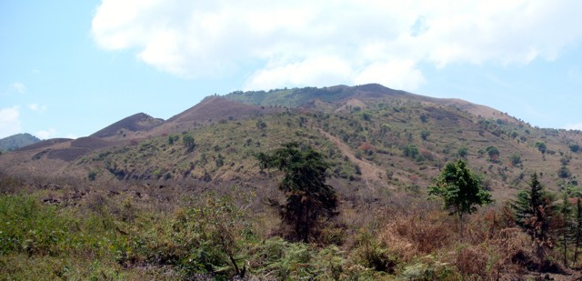
Rungwe volcano
Rungwe is the largest volcano, rising to 2956 m, or 1500 m above the valley floor. The summit is barren, highly notable in the surrounding forest. There is a 4 by 5 km caldera, open to the southwest. Pumice from Rungwe covers the entire local area. The most significant is the 4 ka Rungwe Pumice, traceable over more than 1500 km2. To the southeast, the pumice is found as far as 115 km distant. The isopach contours are nearly circular, suggesting that the plinian eruption took place during a period of little or no wind. The pumice deposit reached 3 meters of thickness near the summit, and is 50 centimeters 20 kilometers away. The total volume is 5 km3 at minimum. Several other eruptions have been dated to less than 1500 years.
Kiejo (source: GVP)
Kiejo is different, It stands about 600 meter above the valley, is unforested, and it is build up by effusive eruptions. It is home to the only historically documented lava flow in the region, happening around 1840. The eruption lasted three days and the lava flows extended for 8 km.
Can we say more about the eruption rate? It turns out, quite a lot. The explosive events have left numerous ash deposits, and the lakes of the rift valley provided the ideal environments for their preservation. Obviously a close lake is better: Lake Tanganiyaka and Laka Malawi contain several ash layers but only for the largest eruptions. The best record is from Lake Masoko, some 25 kilometer away. It contains 70 tephra layers, going back 45,000 years. Some layers are less than 1 mm thick, others are much thicker, in one case reaching 1 meter (the Rungwe pumice of the 4 ka eruption). The average eruption rate is close to once every 500 years, and the typical size of an eruption is VEI4, occasionally 5. The youngest layer has been found in Lake Malawi: AD 1674 ± 13. The large 4 ka eruption came after a period of calm, and was followed by another period of quiescence. But since 1500 years, eruptions have been more frequent again.
Is this something to be concerned about? African volcanoes are not well monitored. There is no sign that an eruption is imminent, but is that because we aren’t looking? And the rift valley is densely populated. 300,000 people live within 20 kilometers of Rungwe. The houses could not withstand a significant ash deposit, and pyroclastics are also possible. Yes, it is worth monitoring the situation. This is best done remotely, using the sentinel missions, since equipment on the ground may not last long before it is used by enterprising locals.
The immediate area surrounding the volcanoes is a nature forest reserve. The Reserve is host to two of the world’s rarest primates, the Kipunji (Rungwecebus kipunji) and the Rungwe galago. But it also protects the human population against the vagaries of the volcanoes!

Hummocky field
There is one more aspect which needs mentioning. Remember the open caldera of Rungwe? It turns out this isn’t caused by an explosion or a collapse. The signs are downslope. 16 km southwest of the summit is an area of low hills, around 7 meters tall, with a hummocky appearance, shown in the photo here. Such an area together with an open caldera is indicative of a flank collapse. It is called a debris avalanche deposit and it can be abbreviated ‘DAD’ if you so wish. The hummocks become taller towards Rungwe, reaching as high as 20 meter. The maximum runout distance is 22 kilometers, and the vertical fall is 1700 meter.
The age is not well determined. The DAD is overlain by the 4 ka Rungwe pumice and must be older. An upper limit comes from a radiocarbon date on the layer below. This sets the ages as between 4 and 25 ka.
The radiocarbon date is itself interesting, because it comes from a deposit that look very similar to DAD. It suggests there have been two such collapses, one around 25,000 years ago and one more recent. There is something unstable about Rungwe.
The DAD shows no indication of volcanic ejecta. The collapse did not involve an eruption. There may have been an earthquake or a rain storm, of course. If the latter seems speculative, the slopes of Rungwe receive 3 meters of rain yearly.
The Rungwe volcanic complex is the most southerly active volcano in Africa. As befitting its location in the terra incognita of the map above, it is little studied. But the study that has been done has shown that this is not a system to be ignored. There is danger here.
Albert, February 2019

Life at Rungwe
This post was based on the paper The Rungwe Volcanic Province, Tanzania – A volcanological review. Karen Fontijn, David Williamson, Evelyne Mbede, Gerald G.J. Ernst, Journal of African Earth Sciences, 63, (2012), 12–31


A bit of a thin post for such an interesting area. I am down with flu and I am afraid his is the limit of my current writing ability.
It’s a nasty one this time, I’ve only just got over it after 2 months.
Cannot sense a flu in your post. Interesting and very enjoyable as allways!
OO! Lovely post anyway…. Sorry about the flu…increase vit C with D and take care of Yourself. All the Best!motsfo
Sorry to hear about the ‘flu, Albert – stay warm! (not easy, coldest night of the year, unfortunately). I was intrigued by Rungwe’s repeated flank collapses, since it doesn’t seem to be tall enough to develop that kind of structural instability; especially if they were ‘cold’ (non-eruptive) events. Any ideas, anyone?
One possibility is that Rungwe used to have a steeper and taller cone which flank-collapsed and then the resulting scarp might have been enlarged by erosion into the caldera there is now.
I hope that the flu abates quickly. Thanks for a fascinating post, regardless.
… so… wetting and heating of the rock… sort of a natural variation on cement? Is there a natural occurrence of calcium hydroxide?
Sounds almost like pozzolana
Thank you for producing a fascinating article whilst ill. I could not do that! I can’t even produce an article when fit and healthy… Africa: an interesting place to watch for volcanic activity. I know so very little about African volcanoes.
The Zicam name is derived from a portmanteau of the words “zinc” and “ICAM-1” (the receptor to which a rhinovirus binds in order to infect cells). It is labelled as an “unapproved homeopathic” product
Following this idea, I use a dietary Zinc supplement from time to time to lessen the likelihood of catching something. I also use a 91% concentration alcohol spray on my hands after working a jobsite. Mainly for the grime, but it’s also a pretty good disinfectant.
10+ M3.0 earthquakes south of Jan Mayen. Any known seamounts in that vicinity? Or was this more of a tectonic than a volcanic event?
They use to be located more to the west along the Kolbeinseya ridge..
Great article! Hope you get well soon.
I really like the 1813 map. The uncharted parts includes an extra curiosity: the completely made up mountain range called “Mountains of Kong” in the west and “Mountains of the Moon” in the east. The latter was thought to be the source of the Nile.
M1.2 at Hekla
Is Hekla one that gives very little warning before it goes ‘pop’?
Not a hard and fast rule, but yes. Hekla gave very little warning in 2000. Maybe 10 to 15 minutes if you were standing at the summit. 60 to 90 minutes if you were camped out next to the coffee pot at IMO watching the seismos and strain guages.
This is one of my spookier plots. It’s the quake sequence for that eruption. The quakes did not exceed the threshold of human perception until just a few minutes before it blew. In other words, at about 15 minutes before eruption, you might have noticed the shaking.
Well, Hekla’s just given another tiny rattle in the same place as the 1.2. Hmmm…
Not sure about this, did not read it since I have no access.
https://www.wsj.com/articles/food-startup-takes-microbes-from-the-volcano-to-the-table-11549256460
Check out the “zipper” of EQ’s off the coast of Pahala on 1/23. The hotspot is very active.
a study on the galapagos mantle plume
https://www.sciencedaily.com/releases/2019/02/190204085936.htm
Anak Krakatau as seen on Saturday. All is quiet..
Time for Anak Krakatau to build it’s dome again.
Actually, I don’t think AK’s really into dome-building yet. Lava flows and Strombolian burps are more it’s style. If/when it gets into series dome-building, time to head for the hills -higher ground, anyway
Okay, I didn’t know that. That tornado that nearly got me back in 1992 was an F4. I was in Smith County when it rolled through. A stand of planted pines just down the hill in what used to be my Grand-Dad’s hay field was sheered off clean about 30 feet up in the air like a giant lawn mower had gone through.
https://en.wikipedia.org/wiki/November_1992_tornado_outbreak
https://www.youtube.com/watch?v=bKgokizhGxQ
Video that has somehow eluded me until now, the first day of the reactivation of fissure 8. At the start there is just fissure 7 which was going for a few days at that point and then lava from fissure 24 but then at night fissure 8 went basically into high gear and took over everything. HVO said the highest confirmed fountain they observed during the whole eruption was 90 meters, but the highest fountain on the left is 150 meters high based on falling time. Videos on this date also include abundant reticulite falling all over the area which is more consistent with a high fountain.
This was at the same time as: https://youtu.be/4ryCx5eqqxw
What a nice mini flood basalt with massive Aa sheets flowing out
just before the large smooth skinned channel system formed
Large eruptive rates
Thanks, Turtle, i enjoyed those… and hadn’t seen the first and it took me right back. Best!from motsfo slurpping up sausage soup and baking powder bisquits and watching snow.
Cornbread, make the cornbread Motsfo…
And a nice stew. 😀
Karangetang is now sending down a grey blocky andesite flow!
It likley cross the road today.
This is a massive slow blocky lava flow thats gas poor.
This is like Aa but much much more viscous than that.
Its very much like Mayon 2006 lava flow.
These large flows are very thick and eruptive rates seems rather high it flowed far.
The andesite here is likley quite hot 920 C and allows it to form a long blocky flow.
Some of the rockfalls and rubble that falls from the front is orange red in daylight.
This blocky flow is snaking its way down to the ocean.
https://www.youtube.com/watch?v=pf910UYhi8E
The blocky lava flow have now crossed the road
that looks very interesting, you can see the mass of lava has moved to the road and below, and that little (if any) is feeling from the source now. It left behind the high lava mark and that part of the flow has deflated.
I just got back from Alaska where I got to observe a lot of glacial activity, and the distinct pitch changes of that flow reminded me of the slow but steady march of ice. this would be the hot counterpart to that.
I think this is similar to Carl’s idea of strapping sub-woofers to his recliner and piping in volcanic seismic signals through a high powered amplifier.
https://www.sciencedaily.com/releases/2019/02/190205134021.htm
Hopefully they use common sense on their “Smells of the Universe.” idea, some of those chemicals out there are poisonous.
Maybe this just me being paranoid but is Mt Aso going to have it’s climax soon?
http://www.data.jma.go.jp/svd/vois/data/tokyo/open-data/open-data.php?id=503
The long term trend for earthquakes are going up and the ash emissions are going down. This reminds of me other large eruptions.
Back to the East African Rift(s): Is there any indication of activity in that ‘gap’ between Lakes Albert & Turkana ?
I can see there’s a sorta ‘kink’ at Turkana but, given the fairly slow spreading rates, no apparent Westward aulacogen. I must wonder if ‘serious’ developments must await future torsion of the overall African plate as it scrunches into the tangle of arcs and subduction zones around the Med…
Not to mention the possibility of the Alboran subduction arc propagating Westward and beginning to nibble at the Atlantic, changing that corner’s dynamics..
… well, you’ve got Los Frailes, Rodalquilar, and Lomilla calderas in south eastern Spain to play with (≈ 14.7+ myr)… and the Canaries could get interesting should that happen.
Hopefully Nemesio wore his brown pants…

No, not a threat against Nemesio. I’m just a deadpool fan and appreciate the character.
For those that don’t know, “Deadpool” is a comic book character with an irreverent attitude and a somewhat disjointed and bizarre sense of humor. The brown pants comment is a reference to a line in the Deadpool movie. It refers to a very old joke about a valient sea captain who always wore a red shirt into battle so that his men would not loose hope in the battle from his blood should he get injured. He always yelled out “Bring me my red shirt” before entering ship to ship combat. Upon seeing an overwhelming flotilla on the horizon, he yells out “Bring me my brown pants.”
Yeah, I can’t believe I’m explaining a Deadpool joke either. But, for those of you who were a fan of the Deadpool movie, and particularly like the portrayal of Wade Wilson pre-cancer, definitely check out “The Hitman’s Bodyguard” It’s a non-Marvel movie staring Ryan Reynolds who effectively brings the same Wade Wilson persona to the movie.
No, I’m not a fanbois, but Reynolds nailed the character… probably as an attempt to make it up to the Deadpool fans who were pissed off at the “Wolverine Origins” presentation of him.
Yes, I am aware that Deadpool-2 was sort of formulaic in setting up the character motivation… but hey, it’s Deadpool. He really doesn’t need a motivation for ultra violence. The rendition of Deadpool in Deadpool2 right up until he got his theatrical motivation for action was true Deadpool. Just being a mouthy ass while he is waging mayhem against his targets, for whatever reason he was there to deal with them. Motivation is only needed if you are trying to tell an actual story.
(A character trait of Deadpool is that he has multiple versions of stage 4 cancer and the “weapon X” healing factor makes him heal as fast as the cancer grows or is injured, leaving him permanently moonbat crazy and unpredictable since his brain cells regenerate as fast as they die.) But underneath the looniness is some sort of core morality that makes him fight for the little guy, hence the seething hatred of pedophiles or anyone that seems to him to be a pedophile. A kid is the ultimate “little guy”… unless of course, it’s “Hit Girl” (different movie and well scored action scenes featuring her. Hillarious dichotomy in audio mood and visual representation.) {She slaughters Razuls gang to the high energy theme of the Banana Splits, a mid 60’s children’s show.}
Oh, BTW, I’m ex military and have had cancer. There is no mysterious pedophile looking character sneaking around to recruit you to some experimental program. Just a doctor and hospital who know how to eliminate the cancer with “robotic surgery.” ← Not really a robot, just an articulation system that allows the surgeon to have much more finesse in his work with much less intrusion. It still feels like you got kicked in the abdomen by a mule when you wake up. (I specifically requested to not remember a damned thing about the procedure after I went in. They did that well.) And yes, I know what a mule kick feel like. I grew up in South Mississippi. It ain’t fun. Well, Mississippi was, the mule, not so much.
With regard to the cancer, I got bizarrely lucky. Other guys around here that are my age have had the same diagnosis and have already died from it. Of course, my primary care physician is scaring the crap out of me with a referral to oncology to check on a monocyte issue, but I’ll cross that bridge when I get to it. His advice “Don’t worry about it.” Umm… okay, but you are looking for something.
One of the worst things that coud happen in Iceland is a Thjorsa or Eldgja or Laki under Vatnajökull
Thats very possible with the hotspot and ridge working togther there.
It woud be the death of Vatnajökull as it cannot recover from the current Global Warming.
First a 30 km long line of huge 2011 like Grimsvötn ash collums stands across that fissure.
The ash and steam collums reach 25 to maybe 30 kilometers.
It completely shuts down the European and American airspaces.
And makes it pitch black for a few weeks in East Iceland
It causes catastrophic floods in sandur plains and over much of East Iceland.
The floods destroys the ring roads and many other roads and farmlands.
The eruptions forms meltwater pools and in them very large tephra piles that shuts out the water.
Later the lava fountains breaks through as the volcanic piles in the fissures shuts out the water.
And 1240 C lava fountains 1200 to 2000 meters tall emerges in vatnajökull.
The lava rivers rage down from the cinder cones and into the glaciers at their sides.
Tahts alot like effusive Veniaminof eruption but on a much larger scale and fluid Hawaiian.
A large long line of Tuyas will form if that happens long line of Herdubreids will emrge in Vatnajökull IF that happens. The sulfur pollution is awful from that and cause a haze thats as bad as Laki.
In Vatnajökull the plume center and mid ocean ridge comes togther.
The possibility of souch crazy events like these are not impossible.
Im soure it have happened before
OO i can see it…… makes sense and a terrific action movie and i hope it doesn’t happen…. Best!motsfo
In the case of an eruption that big I think it would do more than just make a line of tuyas, likely it would melt out the glacier and flow out the gap, or if vatnajokull is a depression it would likely make a massive lake and the entire eruption would be like a plinian version of surtsey. Either way the end result of this is an eruption for the history books.
Icelandic rifting fissure eruptions go completely against the common attributes of volcanism, plinian eruptions erupting superheated nearly ultramafic lava and feeding massive lava flows, it is like the final form of hekla…
Thats a serious possibility one day it will happen
Very silly bulding anything on sandur plains
Grimsvötn will become a very scary volcano in the future if the hotspot keeps boosting up and ridge focus on eastern roft zone
swarm at Reykjanes Peninsula (IMO)

There has been a big landslide at the Cobre Las Cruces mine in Spain. In the image, you can see the collapsed side at the far end, and much of the bottom of the mine is covered by the slide. It is an open-cast copper mine (largest in Europe) and it will take 6 months before it can re-open.
Presumably, the slope on the failed section was engineered similar to the slope in the fore-ground. Any idea if the pore pressure could have changed on the failed section? Any Rainfall events lately?
Hopefully this doesn’t drive copper through the roof. When copper is high, the copper thieves come out. Two or so years ago, they were so bold that they stole the AC units off the top of the County Administrative building in Santa Rosa County. Investigators here in Escambia county found evidence of thieves hitting a live power substation because they got a good hand print of one of them scortched into the side of a transformer. Strangely enough, he survived. They located him via hospital records over in Alabama.
There is blue marl above the copper, and when weathered that becomes very weak. Note that the failure slope is very shallow, indicating a weak material.
Copper thiefs are active anytime. Apparently, the copper prices are interesting enough to risk your live and take the cables of our railway system for years already.
As for “anytime,” I appreciate that. My main emphasis is that when Cu was up near $4.00 USD/lb, they were more motivated.
At a nearby Power Company storage yard, the local Sheriff’s dept keeps a frequent watch over the activities there. One night the caught thieves in progress who then fled. One bailed from the vehicle and tried to escape by running through the back door of an assisted care living facility. They got him as he exited the front. Something inside or the layout slowed his escape and gave them time to be waiting for him.
Cluster of Mauna Loa quakes today.
2.4 22km ENE of Honaunau-Napoopoo, Hawaii
2019-02-06 23:29:55 (UTC)
-0.9 km
2.1 23km ENE of Honaunau-Napoopoo, Hawaii
2019-02-06 22:15:00 (UTC)
4.1 km
1.8 23km ENE of Honaunau-Napoopoo, Hawaii
2019-02-06 12:55:08 (UTC)
3.6 km
1.7 22km ENE of Honaunau-Napoopoo, Hawaii
2019-02-06 12:52:49 (UTC)
5.1 km
1.3 23km ENE of Honaunau-Napoopoo, Hawaii
2019-02-06 12:25:53 (UTC)
2.4 km
1.8 22km E of Honaunau-Napoopoo, Hawaii
2019-02-06 10:17:36 (UTC)
3.5 km
Soon Mauna Loa will become happy!
I simply cannot wait!
The lava rivers will gush and roar and the standing waves dance
The more lava I gets, the more happy I gets too
More quakes and noise on the seismograph in the rift zone.
Check out the green line on the weekly plot … what’s going on there!
https://volcanoes.usgs.gov/volcanoes/mauna_loa/monitoring_deformation.html
Temperature changes: the detector catches the sun. This one shows a very strong day/night effect
Which Rift zone is that? On Hawaii or Iceland? Or Africa? Sorry to be thick…
Edit Add: Unless you have been admonished by the Society for Literary Advancement and Gestation (S.L.A.G.), there is nothing to be worried about. It’s a decent question.
Mauna Loa
Thanks! Poor Gerald Bostock…
I assume he was a Jethro Tull fan… 🙂
I am.
Hah !
Any reference to Tull is very welcome in my book 🙂
And this proud dad got to meet Martin Barre just over a week ago, when my daughter was his support act !
And as I’m in the business of name dropping, I came back from putting her kit back in the car to find her engaged in idle chit-chat with Clive Bunker…. That was just before we got into conversation with Rob Plant, who sang her a few lines of CSN’s “Guinnevere”.
She is now officially deemed “Cool for life”.
Not volcano, or even science, related, but when I was young that was the very first album I ever bought on my own.
What I am curious about, is how Ian Anderson can prance around on stage twirling and swinging his flute with out it coming apart. Are the slip joints glued or taped to keep them from moving?
He doesn’t do too much prancing these days. Shame his voice is shot to pieces.
Looking forward to seeing the Martin Barre Band at Cropredy in the summer. Although I prefer the honesty of people performing their own way, his singer sounds remarkably like Anderson.
That large event appears to be unusual at some distance
https://earthquake.usgs.gov/earthquakes/eventpage/hv70802976
M 4.6 – 85km SW of Hawaiian Ocean View, Hawaii
Time
2019-02-07 19:06:58 (UTC)
Location
18.492°N 156.303°W
Depth
29.5 km
For some context, next to Day Seamount
Reports in several news media on the moving northpole that was mentioned here some days ago. Should depend on changed currents of Fe/Ni deep down. How deep? Or are there alternative models explaining this??
Has nothing to do with volcanoes but something to be made fun of.
https://newyork.cbslocal.com/2019/02/04/rain-tax-likely-to-become-reality-in-new-jersey/
Watch the fun as they try to decide how ‘soft’ or ‘porous’ a surface needs to be to avoid this !!
I’ve seen UK housing estates where, instead of an ugly, solid ‘hard standing’, most drive-ways and parking areas are load-bearing perforated ‘egg box’ tile, ‘naturally’ grassed by seeding rather than turfed…
I’ve also heard of a house-owner being told he MUST replace his ‘solid’ drive-way with ‘soft’. So, he went out with his hammer-action power-drill and perforated the slab on a half-metre grid. It won him a ‘stay’ until the porosity threshold could be agreed. Others found acceptance by replacing some slabs of their drive-way or patio with ‘egg box’, or back-filling with gravel…
Gives a whole new dimension of meaning to that old American phrase “taking a rain check”
Recall being in the boondocks of Tanzania, the guides having focused our attention of a rather small collapsed caldera. But of far more interest was the surrounding plain, populated with unpretentious volcanic cones by the hundreds. More like oversized, conical termite mounds. Regret not taking a few pics, but it was in the days of roll film, which had to be saved for those Attenborough moments on the Serengeti.
Pinacate in northern Mexico (and southern Arizona) has over 600 cinder cones. It is one of the most recognizable geographical features that can be seen from space.

New post is up. The hot young earth when komatiite build the continents
https://www.volcanocafe.org/time-for-komatiite/