This post was published by the author at
https://peakbook.org/Þróndeimr/tour/437021/Vulkanutbrudd+på+La+Palma.html, and is reproduced and translated) here by kind permission by the author.
Volcanoes have fascinated me since I was little but it was not until the eruption on Eyjafjallajökull in 2010 that I looked at the possibilities and began to reflect on the idea of going to watch an ongoing volcanic eruption. Until now, I had considered Iceland as the most likely destination for seeing an eruption. Iceland is nearby and many of the outbreaks there last a long time, which I need to find the time and to have the opportunity to travel there. Then the volcano must be of a small size. An ashy eruption would close the airspace for flights and such eruptions are usually short and intense. That it became a trip to the charter destination of the Canary Islands came as a surprise to myself as well.

This is for several reasons. The volcanoes in the Canary Islands mostly offer fairly stable small eruptions, but they happen so rarely that I had not listed them as a probable place to see a volcanic eruption. At La Palma, for example, a volcanic eruption occurs about every 50-90 years; the eruptions have a duration of between about 20 and 90 days if you look at the previous six historical eruptions. Teide / Tenerife sees 4-6 eruptions over a thousand years, i.e. much less frequently. Lanzarote sees large eruptions in a series which last a long time, but perhaps as infrequently as 2-4 times per thousand years.
Earlier this year, such a “tourist volcano” started in Iceland. Fagradalsfjall Volcano is perhaps the perfect tourist volcano and with Iceland’s policy around this, quite extensive measures were initiated to secure the surrounding areas so that 50,000 tourists could see it up close every week. Unfortunately it had to happen in the middle of the pandemic, so I was unable to go there. And now that the country is reopening, the volcano in Iceland has gone a bit into sleep mode.
Then the volcano Cumbre Vieja on La Palma appeared, just before the reopening at the end of September. I found fantastic cheap airline tickets, so I dropped all plans and some duties I had agreed to, in order to hop on the plane to the disaster area in the Canary Islands. To make sure I would be able to reach the island, I first booked flights to Tenerife. I had planned out the journey ahead but did not book anything until I had landed on Tenerife. The reason for this was that so much was unpredictable, not only in relation to traveling to La Palma during a volcanic eruption, but also at the airports in relation to the pandemic. I had a stopover in Naples, i.e. in a ‘yellow’ country (Italy). The Canary Islands were also ‘yellow’ while Spain was ‘red’. During phase 1 of the reopening only ‘green’ and ‘yellow’ countries were exempt from quarantine upon return to Norway.
When the plane landed on Tenerife after pandemic delays through chaotic conditions in Naples, I had 40 minutes to take a taxi from the airport down to the port and get on a boat to La Palma. The boat was covered in ash from the volcanic eruption at La Palma, a clear step towards the destination! While on the ferry, I booked an overnight box room in an old building in the capital Santa Cruz de la Palma to sleep in, for NOK 200 a night, something I had not tried before and was really excellent!
The Cumbre Vieja volcano on La Palma is a strombolian volcano. Such eruptions are small and stable, reaching 1-2 on the VEI scale (which runs from 0 to 8). The current eruption is VEI 2, with typical tall lava columns and occasionally some ash. It is rare for such volcanoes to produce so much ash that it causes significant problems farther away, but they can produce sulfur dioxide (SO2) and other important volcanic gases.
On La Palma I rented a car and spent the night in the island’s largest city, Santa Cruz de La Palma. The city is located on the east side of the island, sheltered from the eruption which is on the west side of the island. From where I was it was about a 30min drive to the eruption. A marked area around the volcano was closed down. The map can be seen under the Risk Assessment at the bottom of this report.

The first trip into the area was already fascinating. I drove the rental car along some narrow, local roads east of El Paso. The roads were covered with 2-3cm of ash, very interesting to drive on! I parked the car and made my way through the woods to a ridge from where there was a view of the eruption. The risk assessment at the bottom of the report describes which assessments I took before going there. The massive sound from the eruption, as well as two small earthquakes made the experience a powerful one. This was the first trip and in a bit of a hurry I had not immersed myself too much in the up-to-date information from the geologists in the area. I turned back a lot earlier than I could have done.
At this time, the volcano had built up an approximately 70m high volcanic cone. An ash-rich cloud rose from the cone, while on the northwest side of the cone lava erupted from a side valve. The lava that flooded out there looked almost Hawaiian, not strombolian.


To get a better overview of the area and the volcano, I took a trip to Pico Bejenado, a peak of 1852m just 8km north of the eruption. Up to this time, the volcano had ben active from two location. On this day, the main crater erupted a thick and dark cloud of ash rising 6100m into the atmosphere, before falling down again. But lava erupted from the west side of the crater, shown in the pictures above. This lava flowed straight into the cities below and was on its way to the sea.

While I went up, there was a change in the volcano. I felt two new earthquakes. Both were short, around 2-3 seconds and measured 2.9 and 3.1. I had never experienced an earthquake before, so I must say I thought it was very exciting every time. Not long after, the pattern of the eruption changed. As you can see in the pictures below, the main crater went from being in a stable ash eruption to exhibiting pure lava columns, in a more explosive form than those of the side vent. It was a typical strombolian eruption pattern. During this trip the lava reached the Atlantic Ocean and a toxic cloud settled like a lid over the entire area, which you see in one picture further down. This fog disappeared later in the evening when the wind dispersed it.


After the trip up Pico Bejendado it was late at night, but I still wanted to drive to the barricades to see the spectacle up close. I, like many others, stood by the barriers about 1900m from the eruption to look at the lava columns that stood 800m up. Seeing something like this from the streets of the city while it is being destroyed is something I probably will never forget. Something significant is still missing from this report and that is the sound of the volcano. The massive and roaring sound makes it almost impossible to talk to the others near you. It can be compared to a fighter plane taking off, only that it takes off constantly!


I slept for no more than 3 hours through the night, no time to sleep any more! I Went out again and observed the volcano from an area in the northwest, near the town of La Punta. The big challenge on that day was that the wind was very strong from the northeast. The falling ash blew around the island and made it uncomfortable everywhere. Around 70% of the island had been covered by various amounts of ash during the previous days. Inhaling ash was annoying but not much worse: the ash particles from this volcano are so large that they do not go down into the lungs (important with lots of nose hair!) But they irritate the eyes quite a lot. Glasses made it hurt worse when turbulence between the glasses propelled the ash particles into the eye. In advance, I bought a cleaner in relation to such particles.
It was thus set for a day with some distance from the areas closest to the eruption, at least for the first hours while the wind was strongest. From the vantage point above La Punta, I could see the lava flowing into the ocean and the chemical process that occurs when the lava meets water and turns into corrosive clouds. An hour after I sat down on the observation post, the volcano changed its eruption pattern again to a more ash-rich eruption from the main crater.


After a few quiet hours at the observation post in the sun, the trip took me to La Palma’s highest peak, Roque de los Muchachos with its 2426m. From here, of course, the eruption was clearly visible!

Then came the darkness and I wanted to take one last night trip and watch the eruption before my journey continued the next day. The wind still blew from the east / northeast, as strong as before with 15-20 m/s. But now it had been blowing for so long that most of the ashes that could be moved had been moved. With the constant wind direction and the stability of the eruption, it was vest to approach from the east, with the wind in the back while watching the eruption. I explored the terrain and for each ridge ahead there was a short stop to re-evaluate the framework and the risk. I was able to pinpoint an area just over 700m northeast of the volcano cone. The cone had changed a bit in character lately, it seemed to have started to sag in the west edge so that the lava columns also went further out, good of me who was on the east side since I had a good margin in relation to falling materials from the volcano. In the dark here I also met two German “volcanic tourists”. They were very secretive but wanted to get very close as they said. I never saw them again, so possible I was closer than them!


The strongest earthquake I felt was while parking the rental car in the parking basement at the airport. The earthquake measured only 3.1, but it felt more violent than the previous ones in that category. The quake lasted about 3 seconds, but all the cars vibrated, as did the pillars that held the airport up.

Risk assessment

Here I will make an attempt to convince you as a reader that I has made appropriate sensible assessments in relation to the three trips I made close to the outbreak. The map shows these three:
Trip no. 1. Distance from photo location to the eruption: 1900m
Trip no. 2. Distance from photo location to the eruption: 1500m
Trip no. 3. Distance from photo location to the eruption: 740m .
This is my first trip close to an ongoing volcanic eruption so the assessments were made accordingly. For many, it will probably seem headless to go as close as I have done, but I have written down the reviews I have made below. You get a somewhat misleading and frightening picture of the volcano in some media. I was more skeptical even when I went into the area before I saw the eruption, the terrain around, the weather and the wind and all the information from the official sources Involcan and Copernicus. Involcan had a very good information channel on Twitter with information and explanations. Copernicus added good maps and satellite images for good help. Wind and weather reports as well as satellite images and radar images, for which I like to use Windy where you can find webcams and the like. Live video was also posted on Youtube which could be checked when I myself did not see the eruption due to terrain obstacles while I was moving around. Yr also works quite well abroad and provides more accurate weather forecasts than any other service.

Trip 1: This trip was only a few hours after the lava reached the sea and high values of sulfur dioxide and hydrogen sulfide were measured in the area by the sea and up to the area I went into. I was actually going to drive back to the hotel after the trip up to Pico Bejenado , but quite suddenly the wind increased considerably from the east / northeast. It matched well with the wind message and satellite images of Windy and I could see that all the haze and fog that lay like a lid over the cities west of the eruption blew away. Driving down to El Paso, some low haze between the buildings was blown at full speed towards the sea. I drove through one scch fog and it smelled like a thousand rotten eggs. The air became clearer and I drove to the roadblock in the street in question. The roadblock is about 3km away from the eruption, but from there you can enter a new barrier that is manned closer to the eruption (1900m from the eruption). The biggest challenge with the trip was that the wind started to blow up so much that the volcanic ash started to drift with turbulence around the streets. Many other people showed up at the barricades to take pictures.

The distance to the eruption of close to 2km seemed good and that is probably why they have set the barriers here. All the ash and gas from the eruption itself and the lava flows blew in a safe direction at sea. The lava columns were up to 600-800m in height and threw the lava 200-300m out to the sides. A possible risk apart from lava, axis and gas is that the volcanic cone becomes unstable as it grows and slides down on the western edge as it is constructed on a steep slope. It can trigger landslides of hot pumice, ash and lava that can reach a few hundred meters beyond the terrain at the western edge of the eruption. The pressure from the volcano can blow the mass further out to the west, northwest and southwest depending on how the rift is constructed. The volcano was quite fierce when I was here, with lava columns that stood 600-800m up. GPS track from tour no. 1: Approach 3.
Trip 2: The trip went towards the eruption during the day. The wind direction went from west to east, so I approached from the north. There wasn’t much wind so I was tried to keep to the ridges where air quality was best. At this point I did not know exactly how much gas was coming out so I could not assess it well. Therefore I added some margin and kept my distance and stayed where there was some wind. The area had a good shower of ash from the day before, and there was warm ash on the ground, up to 15-20cm where I stopped (1500m from the eruption). I observed many different birds both high above the ridges and down in the depressions beyond (positive in relation to air quality). This mountain side has an inclination of about 10-15 degrees towards the sea in the west, so it takes a lot for high values of gases to remain in this area. I stopped and observed the eruption from 1500m. It was tempting to walk 300m to the next ridge which is the last high marked ridge before the eruption, but notification of a change in wind by the end of the day meant that I wanted to keep the margins while I still did not feel I had one hundred percent control over all risk factors. At this time, the ash cloud from the volcano rose 6100m into the atmosphere. Lava bombs and such materials were thrown up to 600-800m from the crater and up to 300m out of the crater. After the trip, I read the latest report on the gas measurements in the last few days, which gave me more leeway on trip 3.
A little more about gas: Usually SO2 (Sulfur Dioxide) is the biggest challenge in a volcanic eruption. The gas is colorless, but a small amount of it will smell strongly, with a kind of rotten egg so it is easy to detect. The gas, on the other hand, can mix with moisture and come down as acid rain (sulfuric acid), then it will be able to cause damage to the skin and eyes mainly as long as it is not inhaled in a way. InVolcan measured 7,000-11,000 tons of SO2 per day in the days before the lava reached the ocean, a modest value. By comparison, Pinatubo emitted 20 million tons of SO2 over a few days in 1991. A volcano in Iceland emitted 120 million tons of SO2 that killed tens of thousands in northern Europe in the 18th century. Kīlauea in Hawaii also erupted the day after I went on this trip: it spewed out 80,000 tons of SO2 per day for the first two days which can present health challenges if you have asthma or other respiratory challenges.
CO2 (Carbon dioxide) can also come in large quantities from volcanoes, it is both colorless and odorless and difficult to detect without measuring instruments. Fortunately, CO2 is easily transported away by wind and pressure from the volcano so it usually goes straight to the higher layers of the atmosphere. H2S (Hydrogen Sulfide) also occurs and is perhaps one of the more dangerous gases from a volcano as I have understood it. It is formed when sulfur from the magma reacts with water and is often a challenge in volcanoes that are close to lakes, have a large lake in the crater or are connected to large amounts of groundwater. Water is something La Palma is in short supply, both groundwater and lakes are absent from the island. InVolcan did not mention any hydrogen sulphide in its report on the measurements made. Otherwise, different gases are formed when the lava burns through various organic plants, houses, buildings and materials. The gases are easily carried by wind. GPS-Track from trip no. 2: Approach 2.

Trip 3: The wind that had started the day before had blown strongly throughout the day. Strong wind, 15-20m / s from northeast to southwest was blowing ash and gas to the sea. The biggest challenge was all the ash that blew around. The residents down in El Paso had to walk around with goggles. In the media, there was a lot of attention about the dangerous gases that occur and it probably scared those who read it. From InVolcan, which publishes the official information, very few dangerous gases are measured and those living on La Palma are reassured. There was talk of the formation of larger amounts of hydrogen sulphide down by the coast where the lava flowed into the sea and this formed some fog that was corrosive, but not a danger to those who lived on land even though at one point they were encouraged to stay inside one village near the harbor. Involcan had a boat standing close by at all times and never measured high values of H2S while I was on the island. In any case, this was not a real threat at the altitude I was at (600-1300 masl). There has also been increasing earthquake activity throughout the day and some hobby geologists and fans presented the idea that a new and larger crack could soon open some kilometers south of the eruption. The media bought this and some drama unfolded online. This was written off as a probability from an official standpoint with good and logical counter-arguments a few hours later.
When starting the trip I had no goal of where I could get to. I was looking for a safe area with a good overview, preferably with a canopy north or east of the eruption. There are fairly steep mountain sides above the eruption, so if you want to stay safest closest to the eruption, it is from this angle with good wind direction. The eruption was a bit weaker than the day before with lava columns 300-400m high with some fountains and lava rocks up to 500m. Coming closer, I saw that the lava columns angled slightly to the west rather than straight up as yesterday, an advantage as no lava bombs or materials are fired more than around 50-100m east. I thought this might show a weakness in the volcanic cone, sagging on the west side is logical on a fairly steep slope going downhill to the west. This was confirmed two days later when it was expected that there would be a landslide to the west which could change the volcano’s behavior to some extent.
I got into an area just east of the volcano, with some canopy and with a lot of wind in the back, so much so that I had to search a little around to find shelter. Here I was also not completely alone and some geologists were taking pictures (they had driven up with an ATV). There were also traces from 5-10 others who most likely had been here through the day after the wind turned. From here I had a good overview, some 700m from the eruption, and at least 600m clearance of any falling material. Here the ash was the deepest of what I had walked on, between 30 and 50cm. I dug down a couple of places and found that it was quite warm (50-70c) even two days after it had fallen here. GPS-Track from trip no. 3: Approach 4.
So now I have become a volcanic tourist. Fortunately, that is a healthier tourist than the charter tourist!
Christian Nesset


Nice videos of Kilauea in the last multimedia update of HVO:
https://www.usgs.gov/center-news/photo-and-video-chronology-k-lauea-october-12-2021
Kilauea still continues to deflate slowly. The lava lake has gotten 40 meters deeper since the eruption started which is about 22.000.000 cubic meters of magma. To give a sense of scale:
Deflation stopped for a while up to earlier today. When it resumed a new vent opened on the side of the cone, or maybe an older one reactivated. The activity is quite strong for being this far into a summit eruption, maybe this vent will be persistent after all.
That’s true. Now the volcano is inflating again and the tremor is down. The eruption is becoming cyclic like the 1967-68 summit eruption.
James Reynolds
@EarthUncutTV
·
22m
Mt Aso in Kyushu appears to be stirring with risk of lava bombs getting lobbed 1km from the crater #volcano #japan
https://twitter.com/EarthUncutTV/status/1448205464978608132?s=20
Images of
@ IGME1849
, captured yesterday 10/12/21 at 17:00 pm on Calle Paraíso 58 at the extreme North side
It is observed how while a cooler crust is created on the surface, the casting advances by mounting on the previous casts
https://twitter.com/RTVCes/status/1448216629331046400
Thank you so much!
This is the first La Palma footage I can really read 1000 to 1100 °C into 😮
(See 00:03, where cold lava briefly dismantles the hotter lava beneath)
la palma, raising explosive activity.
https://youtu.be/7FUydZYQUA8
https://youtu.be/hoIonND8NnA
Copernicus report. Lava continue to the north.
https://pbs.twimg.com/media/FBjyGcFX0AEMIhq?format=jpg&name=4096×4096
We receive several reports that the smell of sulfides is perceived in the upper part of the North of Tenerife. Possibly the gases from the La Palma eruption have also reached TF. Let’s wait for confirmation
@ 112canarias
Yesterday I could smell sulfides here in Tenerife. (Guia de Isora)
Plus today there is a light dusting of ash on cars but less smell at the moment.
The inflation and volcanic tremor is rising again…
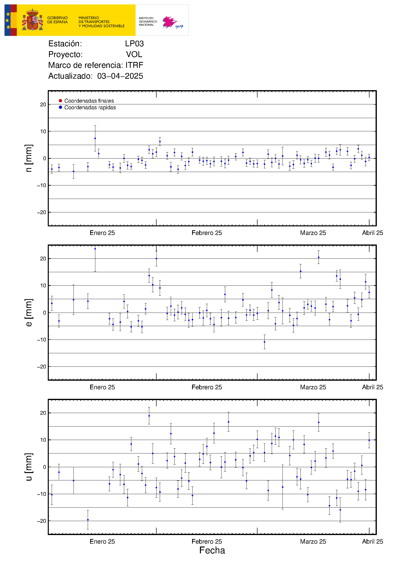
Luis, can we safely conclude that the surface ground is pulsating +/- 3.8 cm at the maximum each day as the LP03 up axis deformation chart suggests? Maybe IGN needs to take GPS readings every minute to do this. We do have very affordable GPS chips now which can do this to +/- 1 cm accuracy if they can tie in to a differential station.
I once helped out on a survey of a volcano (cannot name it) and Trimble complimented us on the 1 cm accuracy, so I know that better readings are possible. One of the Spanish geology doctoral candidates had a map showing La Palma covered with about 100+ stations so it is clear that they do want to carefully watch crustal movement.
We take measurements of the ashfall. The volume of tephra is estimated between 8 and 9 million m3 since the beginning of the eruption
@ManchesterVolc
https://twitter.com/involcan/status/1448247067135066119
Isn’t this ash very valuable for example as an additive to cement. It makes for a superior concrete. I would collect it in bags. Cement manufacture is now considered to be a problem due to energy input. The volcano yields the necessary heat for free.
Roman concrete was far superior to our own, and it was made with volcanic ash as an ingredient, mainly from old pyroclastic flows in the Alban Hills.
I do not know whether or not the La Palma ash is sufficiently similar, but if it is, it’s a kiln-free way of making concrete, and furthermore a concrete that’s much superior (especially in longevity) to the standard modern types.
a new lava flow has destroy some houses on the paraiso street, the roundabout on the la gata path, and flodding part of the rest of east side of industrial park,
https://youtu.be/cRXAr6ZJCNw
Lava flow show by the video (aprox).

“plausible” lava flow direction, flooding the north side of the industrial park.
https://imgur.com/BeS48Kn
I need to update the marks by the last Copernicus pic.
Someone climbed to the rim of the volcano in Iceland
https://youtu.be/JnsPkaTr_II
I don’t believe that, Jesper as it doesn’t make sense. A nutrient poor ocean cannot sustain a family like Plesiosaurus who was only the top predator and was chased in the Cretacious by just Mososaurs and the Ginzu Shark. The family appeared in the late Triassic and was around well into the Cretacious.
Besides there were different kinds of oceans. There was Panthallassa with its own plate tectonics and LIP, and the was horizontal Tethys which at the end of the Cretacious subducted and gave birth to the North-South aligned Atlantic Ocean.
Then there was something special in the early and middle Cretacious: The Midwestern Seaway aka Kansas Ocean, a paradise of marine flaura.
As the Mesozoic is a term for the Triassic, the Jurassic and the Cretacious, all of them, there was obviously a lot of change. The worst conditions on Earth for life seem to have existed at the end of the Permian when water levels were low with exposed shelves and 96% of species went extint.
Afterwards there was a slowly starting but then rapid radiation of life in the sea, in the air and on the continent(s) including Pangaea.
Aside from that all specias show a bell curve, slow growth, then radiation, then decline, possibly only partly dependant on conditions. Afterwards they are replaced by relatives, sort of.
Belongs to Jesper, yesterday, 12.06.
Warm Seas are crystal Clear and Blue
And very poor in nutrients
Hawaii is an oceanic desert .. almost lifeless in plankton.. lack of nutrients
Water is too warm and its too far away from land
But the coral reefs thrive in these marine deserts, specialy adapted for it.
Meozoic Calcite Seas where warm and nutrient poor .. But with huge reefs that required these barren conditions. Plesiosaurus found lots of fish to eat in these oases..
Mesozoic is too long to make such a statement. There were three periods, Triassic, Jurassic and Cretacious, all with different conditions.
Triassic was Pangaea, hot and dry with monsoons, Jurassic and Cretacious was the break-up of Pangaea with changing oceans and also mountain chains. So, you cannot generalize like that.
Volcanism was especially prominent in the Cretacious with the Dinosaurs probably already starting to go extinct (Gerta Keller, Princeton, Deccan Traps) before the impact.
You are making a statement about a long period consisting of three totally different periods, the first one with a super continent, the last one with separated continents with high sea levels.
And what do you mean by “calcite”? The calcium found around the borders of former Tethys and on the ground is mainly the carapace or shell of small organisms. So there was abundant life. And the organisms themselves turned into crude oil. So when they drill for oil they always find Chalk first. You mean that?
Its unwise to assume conditions everywhere were the same.
Mostly because they almost certainly were not.
Tectonics where very active during the Pangea breakup in Jurassic as well as rapid seafloor spreading during jurassic and cretaceous
That keept CO2 high back then, specialy the rapid seafloor spreading outgassing. Cretaceous Thermal Maximum and Late Triassic Maximum where the hottest parts of Meozoic, caused by volcanism.
Calcium – Calcite Sea is a global chemical state of the ocean that are result of very active tectonics, as seawater interact with hot new seafloor.
Today seafloor tectonics are not as active as during say just after Pangea breakup, today We haves ”aragonite ocean”
Today humans burning burning fossil fuels are resposible for all of the extra CO2.
The solar luminosity have gone up 1,5% since Jurassic ended so the future supergreenhouse made by the massive human industrial cO2 emissions maybe even more severe in the future than earlier natural hothouses. Infact if we dont stop our massive emissions, we will end up in the Cretaceous Thermal maximum again..
in just 200 years perhaps… knowing how fast the cO2 rises now because of us.
Well who knows? It is a long process, this opening up of the Atlantic and Indian Ocean. It started at some point in the late Triassic. So, give it 200 million years and figure out the distance from Africa or South America to the MAR. It seems to be a slow process to me.
India travelled much faster though, and there was the centre of volcanism to be admired in the Deccan traps.
The fastest spreading centre today is the South-East Pacific rise. So, there were and are huge differences.
And Panthalassa and the heir Pacific Ocean is very different from Tethys and her heir the Atlantic Ocean.
Its also possible that the revolutionary emergence of broadleaf forests in Cretaceous helpt to make Earths land soil more fertile.. than pine needle soil
These washed into coasts
By Early Triassic there where
No broadleaf soils at all.. there where Only conifer forests and fern prairies and soils must have been acid and low in nutrients
By Latest Cretaceous 160 million years later the land forests where mostly of flowering broadleaf forests. As today. Souch leaf soils are more fertile and decompose faster. But these forests where also tropical and subtropical where most of the nutrients are stored in the Trees and not in the soil
The cooler Current cenozoic oceans is is mainly more fertile because of cold poles and cold nutrient rich upwellings in a cooler glacial climate.
Filter feeding whales evolved because of a cooler richer ocean with more plankton
Yes that’s what is thought, but I have some doubts about that theory. In Southern France you happen to have a thick cover of old beautiful conifers over a vast area.
And then you have the most beautiful flourishing plants like Bougainvillea, some wild. And then vine.
In Germany and England we have deciduous trees or mixed forests, different blossoms and much less vine. German vine is best in the Rhine area, and that is a Graben structure and warmer then other parts of the country.
When I see the South of France I wonder if the no blossom theory is valid. It was a long time ago. Not everything that existed is preserved. The bat for instance has such thin wings that only few samples are well preserved.
My favorite tree in England is the Yew Tree, a conifer. They have beautiful old Yew Trees, esp. in National Trust Parks.
https://twitter.com/RTVCes/status/1448269997344755724
Lava reaching a water deposit
https://twitter.com/RTVCes/status/1448268938542997504
Lava near supermarket of La Laguna
https://twitter.com/RTVCes/status/1448282131386535945
Lava flow advancing on La Laguna
That lava is really looking dangerously hot 😮
A lot of smoke on this lava flow section
The lava has move on two routes. Upper arrow has a slow lava flow by the “Camino Cumplido / Cumplido path” on direction to la laguna. Lower arror has boarder the SPAR La laguna comercial center and get into the “Camino Cabreja / Cabreja path”

4.2 mbLg NE FUENCALIENTE DE LA PALMA.IL
2021/10/13 14:33:48
36
Revized up to M4.4 at 36Km
Strongest in the event. Felt along all the island.
That must be a bit frightening. Are you there?
Largest earthquake to date during the #LaPalma eruption
Although, as we always say, it is susceptible to change as the data is reviewed.
Magnitude 4.4 and 36 km deep
https://twitter.com/ita_dc/status/1448303173169557507
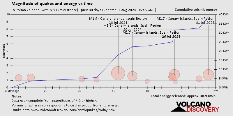
Total earthquake energy on la palma on 30 days.
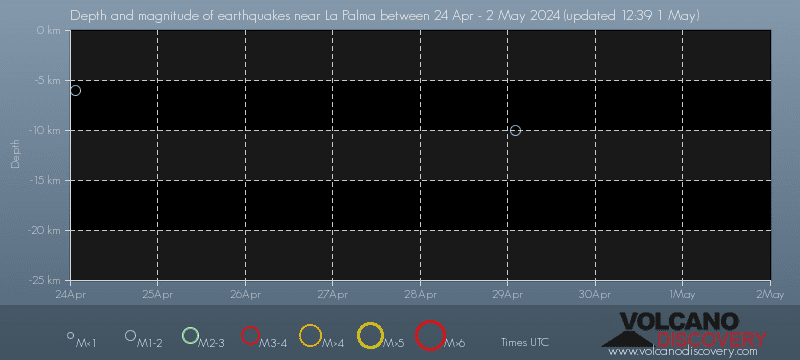
Depth vs magnitude
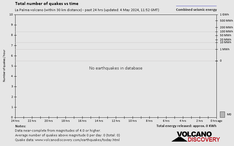
Total Earthquakes
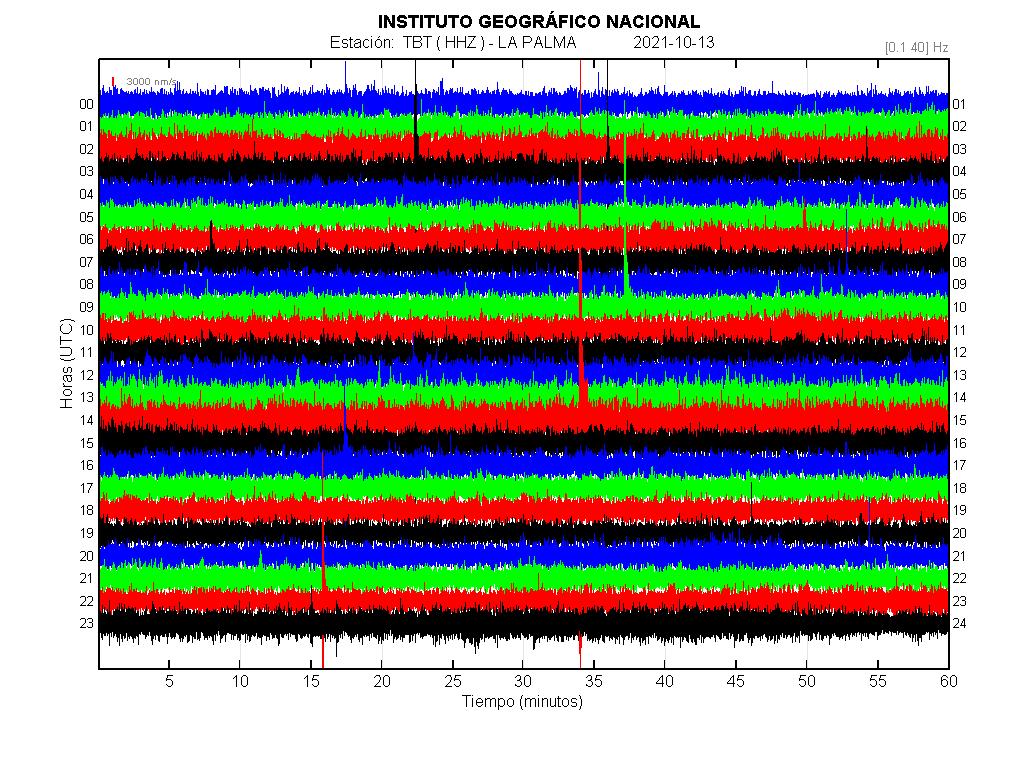
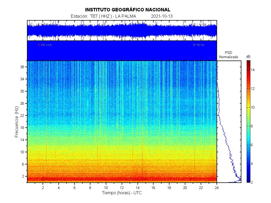
La palma sismometer:
Notice how it isn’t returning earthquake data below M2 now (The yellow circles), they showed up on the buildup to the eruption.
I did read somewhere they can’t properly determine how many smaller earthquakes there are due to the amount of bigger ones causing a sort of background noise, so not sure if that’s the case?
http://www.casamartin.de/kolumne/kolumne_la_palma_aktuell.shtml He is saying (somewhere) that the small quakes get lost in the tremor.
I read the same from another blog, too.
stunning views on television canaria. the small effusive vent has grown to be similar sized to the explosive one behind it and is exploding too.
Stromboli 2…
Just that it has a continuous “Sciara del Fuoco”, which unfortunately doesn’t really lead into the sea :/
It took me awhile to process 412,695 frames [3 hrs 49 mins 16.5 secs duration] from the Directo TV live camera feed of the eruption on the night of Monday Oct 10th to Tuesday morning Oct 11th, but a careful ImageMagick script file was able to successfully locate 4 lightning flashes from the 3 vents. It appears that the smoke on the 1st vent (southmost) was necessary for the flashes to occur. You can see the flashes here https://drive.google.com/drive/folders/1D777bOvuwXd0lmrJ9w8b3VSRhPFi_H7S?usp=sharing
Askja has reached 14 cm inflation since August, with some good earthquakes, hopefully it produces an incredible VEI 5 eruption
This together with blackouts that are looming would certainly heal some people from hysteria. We had a very cold summer here in Bavaria, and yesterday we saw the first snow reaching down to 800-900 metres above sea level. I for my part enjoyed 30°C for a few days in Southern France.
Science is okay, but not the media and TW hysteria. Sth that wasn’t reported during the wildfires started probably by a cigarette: Strong Mistral.
Some cathastrofistic has claimed the la palma volcano coming to falling, by some “cracks” on a IGME drone video (I think that has old lava tubes).
https://youtu.be/W2cMb7te4cA
Other catastrofistic “claims” talk about a new volcano coming to the east side of la palma, on el paso, by the big 4 earthquakes on the last days and that can “insolate” the south of la palma…
Meanwhile, the night show some new lava flows on the north of industrial park

The large quakes on the ‘east side’ where mainly very deep quakes. Magma does not rise that horizontally on Palma. The sideways movement of lava, as seen in your picture, is cause by big blocks of scoria that are transported by the lava river that come to a stop at some point. Then they block the flow so the level will rise and go over the side of the lava channel. The scoria blocks come from cone collapses. We saw that happening too in Meradalir.
Meanwhile in Christian Nesset’s Norway four people killed by a single attacker with bow and arrow. I didn’t know that they have resurrected American Indians there.
Please refrain from using outdated and potentially racist terminology. ‘Be nice’. Thank you
The term was not meant to be racist. However, it is better not to make fun, however lightly, about a terrorist attack.
You are right, Albert. It was about the choice of weapon, but still superfluous. I happen to like the First People of America and their history. So,apologies for who it might hurt. Didn’t belong here anyway. I tend to become too cynical sometimes.
Appreciated.
Thank you. It also wasn’t considerate towards the victims, five, and their families. I had a bad feeling right afterwards like after every bad joke.
It’s better to add this here: Carl might have made a slight mistake: It Cameroon has a mantle plume it would have been further inland in the past considering the plate movement.
It’s possible that all those islands including the Canaries have a different story.
Collapse of a potion of the vent at 21:32 On AFAR. The upper left portion.
I noticed some people said that the Canaries hotpost was quite a weak one, however I was watching a video from Geology Hub where he talked about Gran Canaria. He mentioned that there is a caldera on the western side of the island that produced a VEI 7 eruption back around 13.9 MYA, and more recently VEI 4 eruptions, I was intrigued as the Smithsonian site dosen’t say much about it’s eruptions.
He said that to determine that he performed a basic calculation for VEI of the destroyed rock in the latest eruption. Generally tephra takes up 2.5x the volume of the solid rock destroyed in an explosion.
It can produce large sillic eruptions as magma is allowed to accumulate over long timescales.. large Sillic pyroclastic eruptions are often but not a always a hallmark of slow magma supply.
Hawaii,Iceland and Galapagos and even Reunion still haves a much much higher supply than Canaries haves ..
I doubt the Canary Hotspot woud form any Islands at all in Hawaiis Location.. the seafloor is moving too fast there and the sea is too deep
That explains it, so really the “weakness” was more to do with the output of lava creating land over time rather than explosivity power etc.
The Azores has had some very explosive eruptions, not sure how that hotspot compares to the Canaries in terms of lava ouput (although that has 2 plate boundries running through it).
Based on historical activity the Canary islands are probably more active, there has not been any large basalt eruptions in the Azores in the last 1000 years and that is generally an indicator of magma flux.
Thing is Lanzarote is the majority of lava erupted by the Canary islands in the recent time, and it is very infrequent. But then it is maybe foolish to assume the other islands are incapable of erupting that big too, we might well be watching this right now as a matter of fact.
I think the Azores is also highly episodic, there were a lot more eruptions a few hundred years ago. On the same line in the time from 1736 to 1949 there were only three eruptions in the Canary Islands This year is only the 7th eruption in the islands in nearly 300 years.
Maybe we are just spoiled by Hawaii, where there has not been a decade without lava since the islands were discovered.
The large inactivity period of several million years in gran canaria, maybe some ay la gomera will wake up too?
Gran Canaria was an enormous caldera long ago. More recently it grew into an explosive stratovolcano that covered the entire island in thick pyroclastic flow deposits (Roque Nublo). But now it is down to small mostly effusive eruptions.
The one doing big explosive eruptions now is Tenerife, but it goes in cycles. It produced a VEI-4 eruption 2000 years ago. Most eruptions are effusive though.
I can`t figure out why la Gomera is the third youngest of all, but extinct.
“La Gomera is one of the most beautiful of the volcanic Canarians. It is a heavily eroded ocean island shield volcano. Although it is the 3rd youngest of the Canarian island, it is already extinct. It stopped erupting about 3 million years ago.” Quote from volcanodiscovery
Its position is between Tenerife, La Palma and El Hierro (all active.
Azrou Volcanic Field, Atlas, erupted last 600.000 years ago.
Azrou and La Gomera together plus the surrounding active islands don’t align well with the plume theory (plate moving over plume).
Yeah this always struck me as unusual too.
I would assume there was a mantle plume once when the West-African Craton was over the same position:
See maps here:
“African cratonic lithosphere carved by mantle plumes”, Nicolas Luca Celli et al.
https://www.nature.com/articles/s41467-019-13871-2
Could be gone.
Well gran cnaria and other islands had restive periods of severa million years, we may see it it in our lifetimes but maybe one day it will erupt again.
Like Gran Canaria, that had several million years of inactivity between tejeda and roque nublo series
*may not see sorry
Wow super hot magma like fluorescent white erupting now.
Jan, what is needed is a calibrated infrared camera. I guess only the USGS can afford cameras like this, the rest of the world goes without. A calibrated camera would allow us to accurately gauge lava temperatures. Earlier this year when Geldingadalir fissures opened up I was fooled several times by the camera gamma settings into misbelieving lava temperatures, usually guessing too high. The camera made the gas flares seem like a super lava eruption, it never occurred, but camera shots can be misleading.
The magma is spewing out yellow on the side and top with a super bright white circle in the middle the smoke is an orange colour.
They have that on La Palma, it is just not public, and I have the impression it is a mobile that they set up in different locations while doing fieldwork. IGN shares pictures of it sometimes on Twitter.
More evacuations up to midnight .Part of the cone collapsed.
https://twitter.com/RTVCes/status/1448401568261451786
Our good friend GutnTog from Iceland reporting, wow he gets around! That airfare must be a lot.
Summer hols, warm and not wet, what’s not to like?
Could be two persons. Joint venture.
Look at Mark Stewart’s (there are lots of them, I mean mountainmarkphotography) recent pic of Mount Rainier with polar lights behind.
Irony? Yes. He’d have to go from Iceland to London, then to Tenerife, stay over night, then take the boat.
1. High costs.
2. Four days back and forth.
Conclusion: He is only on one of the islands. My bet is on Iceland.
Don’t know what Palma fares are like, but Iceland/UK flights are cheap, so are UK/Barcelona and I think there are flights direct from there.
Will use a lot of time though. If I went to Palma I’d want to stay a few days.
No. You cannot fly to LP at the moment. Via TF or GC is possible.
https://twitter.com/aena/status/1448544334048079872 (translated)
https://www.aena.es/en/la-palma.html
Next Arrival
14/10/2021 13:37 NT621 Binter Canarias TENERIFE NORTE-C. On time
The column looking so dark is simply shadow…. because clouds are to the west over the column and the sun is far to the west You can deduce that from the rather long shadows on the people’s clothes and on the ground.
Today there was an episode of strong activity at Kilauea from 10:30 to 19:15 HST, as shown by increased volcanic tremor. The tremor coincides with a rapid deflation of Kilauea, which is preceded and followed by inflation. As such it looks like the eruption might be turning episodic. The summit eruptions of 1959 and 1967-68 were episodic too.
If this plays out then the vent is probably going to stay around a while, 1959 and 1967 both only ended because magma started going into the ERZ, but the elevation of the lava in Halemaumau today is probably still too low for that to happen just yet.
1967-1968 was erupting through the middle of Halemaumau, through probably still liquid lava from earlier eruptions, but today the only active vent now is pretty much on its own, just like 1959. Lava geyser 🙂
Two new 112 videos
https://www.youtube.com/watch?v=jnMwx_V-ZK4
weekly bulletin of Vulcano: https://cme.ingv.it/bollettini-e-comunicati/bollettini-settimanali-vulcano/850-bollettino-vulcano-12102021/file?
i translate this part:
EXPECTED SCENARIOS
The possible phenomena expected in the short / medium term are listed below:
further increase in fumarolic and diffuse degassing;
increases in the temperature of gases and their flows, with variations in the
thermal aquifer;
increase in seismicity linked to hydrothermal activity and the appearance of
volcano-tectonic seismicity;
increase in deformations;
slope movements;
explosive impulsive phenomena such as
phreatic explosions.
New vent just opened up around 23:57 pm CET time, just north of vent #3 (northmost vent) and is spraying lava into the outflow channel https://www.youtube.com/watch?v=INvrtMg5tSQ and it is growing in strength as I watch
Volcano very quiet at 12:58 am CET time and died down
2:28j am CET and now 2 vents inside vent #3, one gas the other lava. interesting, seems the new vent is diminished now
So Guten Tag made it to the La Palma!!!
the house people left the cat to guard the house…. doing a good job too.
New evacuation order.
https://pbs.twimg.com/media/FBm9DvyWQAMNzsp?format=jpg&name=large
https://pbs.twimg.com/media/FBm9XAKWEAMkvV5?format=jpg&name=large
The actual evacuation zones, I think that will be expand to north and West.

Seriously gutntag is in la Palma? Awesome.
Collab or volcano debate with bushcraft bear plz.
I cannot tell 100% if he is there or not, it seemed like he was because he said “most people speak Spanish” and it seemed that his movements corresponded with his speech. He also mentioned the rumbling sounds and admitted fear, so I assumed he’s there live. (not 100% sure)
He is there….
At the agricultural plant in the parking lot we see about 15 vehicles now cut off by the lava. In another place I saw a flatbed tractor trailer and a Caterpillar shovel at the same plant (another video).
I saw similar stuff at some houses.
Why was there no attempt to remove these vehicles before they were cut off by the lava?
Absalom Hicks. That 15 vehicles was part of a scrapping yard business know as “Desguace la Palma”.
https://es-es.facebook.com/desguacelapalma/
Other equipment can be part of the cement plant and a sand mining. I think the last was abandoned some years ago. Some days ago, great quantity of material was evacuate to the industrial park, include heavy equipment.
Awesome? Don’t think so. Just a drone knight, obviously well stuffed with money. What this Chris Nesset here produced is awesome.
Still no 4K high def. amazing.
The eruption has got a lot less explosive this past few hours, and now there is a hawaiian style fountain again, no ash just lava and it looks like possibly more of a lava pond in the crater, which could end up feeding more pahoehoe flows than a’a flows. Been wrong a few times by now but maybe this is finally the deep stuff erupting, the other vents are still going but not violently, the eruption is pretty much only effusive now by the looks of it.
Really looking like this could be a huge eruption for this area, being already possibly the biggest of all the historical eruptions on the island and still erupting magma that was from the upper levels of the volcano. The volume estimate on the AfarTV livestream is close to 140 million m3, not sure how accurate that is but the combined volume of the 1949 and 1971 eruptions was less than 100 million m3 so this is getting pretty serious.
Yes I’m with you on this.It seems the eruption has settle for a longish event-at least longer than most expected.This eruption will be long studied for years ahead.
Your comments are awesome too, Chad, I like to read them, lots of knowledge. Needs to be said.
Q: If you look at the big scar Taburiente has left, are you sure this one will be bigger?
The big scar on the older part of the island is not volcanic, erosional feature, so not quick to make. Cumbre Vieja also hasnt got a shallow large magma chamber, probably none of the Canary volcanoes do except maybe Tenerife, so there cant be fast lava floods or calderas really. The eruption now seems to be fed from several deep magma chambers, it is probably going to last a long time really, though it is never certain. Big eruption is maybe 1 km3, which would take a long time probably close to a year.
Thanks.
IGN Sismología
@IGN_Sismologia
· 3 h
#terremoto 14/10/2021 01:27:59UTC SW VILLA DE MAZO_ILP mag=4.5 prof=37km cálculo revisado http://ign.es/web/resources/sismologia/mapa.php?evid=es2021uctrv
I dearly love this:
“Gillian Foulger writes: In 1963, Wilson1 suggested that there is a hotspot in the mantle, which is forming the time-progressive Hawaiian island chain as the Pacific sea floor moves over it. Within a few years, this hotspot had migrated to the core-mantle boundary, replicated itself into 20 plumes, each 3000 km tall and with a giant plume head, and these were driving the newly discovered tectonic plates2. It was pointed out that, given the rate at which plumes were multiplying, someone urgently needed to prove that they don’t exist before it was too late. Despite this timely warning, by 1999 the number of deep mantle plumes in the Earth had reached a critical 5,2003. Fortunately, the crisis was averted in 2003 when their number crashed to only 94. These extraordinary fluctuations in the plume population probably tell us more about Earth science than the Earth.”
https://www.geolsoc.org.uk/plumesdebate
I think in the 5000 sth there is a number too much.
Nice for laughing too, same article:
“To be fair to plumes, however, they have served geologists well for over 30 years. In 2002 several hundred papers about them are listed by the Science Citation Index, so the subject is paying a lot of mortgages. The assume-a-plume approach has also relieved researchers of the hard work of thinking up new theories – a welcome relief in these days when we are all expected to publish six papers a year or else. However, the time may have come to retire plumes on a full pension and make way for younger theories – or are they really older ones recycled?”
That’s beautiful writing. Nice to see academics who can take the p**s from time to time.
What are the newer theories?
Gillian Foulguer is one of the architects of ‘plate theory’, the idea that all volcanism can in some way be explained by natural tectonic processes and geological systems in play – for example a thin stretched crust with pre-existing faults (like the Canary hotspot!!).
It doesn’t explain everything, but it certainly has merits for many patches of volcanism that were instantly termed ‘hotspots’ without taking into account other factors.
http://www.mantleplumes.org/PlateTheory.html
The whole mantle plumes website debates whether or not a mantle plume could be in play for many volcanic systems and LIPs across the world.
There is also somewhere on that website a page where they rank all of the known ‘plumes’ in terms of likelihood of being a plume. I believe Society hotspot was the most likely but can’t remember off the top of my head.
She is a top scientist, brillant education, and she can write. Basically what she does is to explain science. She states rightly that there should be room for falsification. She has a sense of humour, is sober and open for debate.
One day the truth will be somewhere in the middle maybe, like the debate in Paleontology about the 66-67 ma extinction.
Hawai’i’s plume seems to be on solid ground. The proliferation of plumes after Wilson is astonishing though.
I think she is a great lady with a very scientific approach, and it is very well possible that she is our closest link to Drummond Matthew, Frederick Vine and Harry Hammond Hess.
I think the plume theory is on more solid ground when there is no other possible explanation. There is no continental shelf near Hawai’i i.e., and there is the beautiful line of the Emperor Chain.
There is no continental shelf protruding into the Pacific at all.
And that is one of the main differences between the Atlantic and the Pacific Oceans.
What I linked on comments page 2 by Van den Boogard is one of the newer theories.
Thanks for all replies. This is very interesting. I remember reading in a paper that the crust below the Canary islands was 130km (!) thick. That struck me as very odd.
What I also do not understand are deep earthquakes (like 500km), sporadically reported. How is that possible so deep in the mantle which should be plastic not rigid?
500 km depth normally indicates an error in location. However, there are some places where earthquakes this deep happen. The best examples are in South America. These come from descending oceanic plates, which are being subducted. They can remain solid (cold) far down
Addition that might be of interest (graphs). Explanation: Moroccon microplate is supposed to have staid close to America first and joined later:
https://www.researchgate.net/figure/a-Simplified-tectonic-sketch-of-the-Central-Atlantic-showing-the-geometry-of-the_fig5_322315991
Ok, new night with 3+ powerful earthquakes with other record:
3.4 mbLg SW VILLA DE MAZO.ILP 2021/10/14 10:09:27 S 11 +info
3.0 mbLg NE FUENCALIENTE DE LA PALMA.IL 2021/10/14 08:50:52 11 +info
3.3 mbLg NE FUENCALIENTE DE LA PALMA.IL 2021/10/14 08:09:53 10 +info
3.1 mbLg SW VILLA DE MAZO.ILP 2021/10/14 08:03:45 11 +info
3.5 mbLg NE FUENCALIENTE DE LA PALMA.IL 2021/10/14 07:40:39 III 11 +info
3.4 mbLg SW VILLA DE MAZO.ILP 2021/10/14 07:28:52 II 10 +info
3.2 mbLg SW VILLA DE MAZO.ILP 2021/10/14 07:15:29 13 +info
3.1 mbLg SW VILLA DE MAZO.ILP 2021/10/14 04:49:52 13 +info
3.3 mbLg SW VILLA DE MAZO.ILP 2021/10/14 04:46:04 11 +info
3.6 mbLg NE FUENCALIENTE DE LA PALMA.IL 2021/10/14 04:32:51 II-III 10 +info
3.0 mbLg NE FUENCALIENTE DE LA PALMA.IL 2021/10/14 02:44:38 10 +info
3.1 mbLg NE FUENCALIENTE DE LA PALMA.IL 2021/10/14 02:42:07 11 +info
3.0 mbLg SW VILLA DE MAZO.ILP 2021/10/14 02:41:22 10 +info
3.1 mbLg SW VILLA DE MAZO.ILP 2021/10/14 01:53:21 12 +info
4.5 mbLg SW VILLA DE MAZO.ILP 2021/10/14 01:27:59 IV 37 +info
4.2 mbLg SW VILLA DE MAZO.ILP 2021/10/14 01:27:56 37 +info
3.4 mbLg SW VILLA DE MAZO.ILP 2021/10/14 00:21:33 39 +info
3.4 mbLg SW VILLA DE MAZO.ILP 2021/10/14 00:21:22 42 +info
3.0 mbLg SW VILLA DE MAZO.ILP 2021/10/13 23:16:44 11 +info
3.1 mbLg W VILLA DE MAZO.ILP 2021/10/13 23:14:50 37 +info
The actual energy liberated:

Las 24 hours:
Total:

In 3 weeks a new mountain…

You seem to have set the near tree for scaling. To avoid errors of scaling (due different lenses for example) bet to pick two widely separated points as far away as possible to match. You may need to alter the picture size of one as well to get a fit. Takes ages, it has to be said.
That said you are doing a great job and I appreciate the view so do not take this as anything than nit-picking.
Thanks but the pic it’s not mine… it’s everywere… i didn’t saw it posted so i did it.
Oh, there was me thinking you had produced it!
The stuff you find is great, so keep it coming.
but the houses match…. aren’t they enough?
The scale is right, but because the background is missing the cone may look bigger than it is. You can’t judge distance and the brain puts the cone as far as the hills in the other image. It is in fact not that far from the photographer.
By the TvC direct, La laguna football camp has been flooded by lava flows.
https://youtu.be/INvrtMg5tSQ
La Palma Tv camera has disconect by problems with the electrical service (has been blackouts)
New evacuation zones…
https://pbs.twimg.com/media/FBpvt-cWUAEl9-5?format=jpg&name=large
https://pbs.twimg.com/media/FBpvxIxX0AAF5dM?format=jpg&name=large
Actual evacuated zone.

That expand the more and more…. I have a bad filing about this. The next can be the La laguna Tazacorte Road and that can be a clear path to a lava flow can be turn to Tazacorte and coast neighborhoods.
Ground deformation continue raising
LP03 detector…. see the peak
https://twitter.com/involcan/status/1448605783290220546
They should make those bollards out of tougher stuff! 🙂
Sure is dramatic, tk you Luis for first inkling of this. Its a bit scarey, but chief spanish guy volcano guy says as long as this vent is open all is good.
Just hope so… we don’t nead more drama here… but the inflaction climbing again and new max quakes is worring me…
Van den Boogard, whose interesting paper I linked on comments page 2 also refers to Samoa, so I checked this, and here we are again:
“rock samples from Savaiʻi were too young by several million years to fit the classic hotspot model of age progression in an island chain, raising arguments among scientists that the Samoa islands does not have a plume origin.”
https://en.wikipedia.org/wiki/Savai'i#Geology
Here the explanation is assumed to be in the Tonga Trench.
New gutntog video filmed from the top of montana la laguna, showing how close the new lava flow is to entering the sea
https://youtu.be/qMShQ23hrt0
Jeez, I wish he would keep his camera still for just half a second.
3.1 mbLg NE FUENCALIENTE DE LA PALMA.IL
2021/10/14 13:01:15
31
+info
3.8 mbLg SW VILLA DE MAZO.ILP
2021/10/14 12:38:59
37
Lava flow today extension.
https://pbs.twimg.com/media/FBqUdE6XsAUhlz7?format=jpg
New flooding
https://twitter.com/involcan/status/1448653285175410702
This is simply horrible for the people living there.
https://www.ign.es/web/resources/volcanologia/html/CA_noticias.html (translated)
“The height of the eruptive column measured at 6:30 UTC is estimated at 2,600 m.”
Must be a mistake.
You won’t find a mountain in the entire eastern alps where valley floor to peak is 2600m.
London Missionary Church after Lavastream from Manatavu, Samoa:
https://natlib.govt.nz/records/22856627
Today, same church, touristic point of view:
https://www.samoa.travel/plan-book/activities/saleaula-lava-field/
The eruption happened unexpectedly after a quiet period of around 100 years and went on for six years.
Hot day incoming:
Date # Num_Quake # KiloTonsTNT
2021-10-14 # 80 # 3.7315
2021-10-13 # 66 # 6.3151
2021-10-12 # 69 # 4.1231
2021-10-11 # 74 # 2.9915
2021-10-10 # 125 # 8.5225
2021-10-09 # 142 # 6.5023
2021-10-08 # 60 # 4.7223
2021-10-07 # 86 # 6.3139
2021-10-06 # 54 # 4.3007
2021-10-05 # 46 # 3.4650
2021-10-04 # 88 # 3.0816
2021-10-03 # 34 # 1.4409
2021-10-02 # 45 # 0.8361
2021-10-01 # 17 # 0.6732
2021-09-30 # 10 # 0.4411
2021-09-29 # 18 # 0.2641
2021-09-28 # 12 # 0.5062
2021-09-27 # 10 # 0.0768
2021-09-26 # 4 # 0.0204
2021-09-25 # 4 # 0.0306
2021-09-24 # 2 # 0.0132
2021-09-23 # 2 # 0.0099
2021-09-22 # 5 # 0.0385
2021-09-21 # 15 # 0.1005
2021-09-20 # 10 # 0.1366
2021-09-19 # 140 # 0.8626
2021-09-18 # 117 # 0.1982
2021-09-17 # 12 # 0.0221
2021-09-16 # 40 # 0.1608
2021-09-15 # 98 # 0.3946
2021-09-14 # 270 # 1.8803
2021-09-13 # 221 # 1.4452
2021-09-12 # 159 # 0.6850
Updated 4pm, 14/10: Concerns have risen this afternoon. Significant seismic activity continues and lava is currently fountaining, so things are little different to the last few days in these respects, but problems are now compounded by yet another collapse in the northwest flank of the main cone with further lava flows pouring through. The result can be seen clearly in the Involcan video below from an hour or so ago, but volcanologists say that even more lava than can be seen is also coursing through the newly formed lava tubes that are channelling the coladas downhill, literally pushing the problem down to the coast.
Adding to concerns is the rate of seismic activity as distinct from magnitudes of individual tremors: the rate has increased such that double the number of quakes have been recorded today compared with yesterday. In addition, ground deformation has occurred again, which volcanologists think could indicate intrusions of magma into the volcanic chamber exceeding the quantity being emitted. In other words, pressure is building internally which could lead to further vents forming. Worrying hours.
@ Jesper
I was looking for some literature and just found this which might interest you (and some other Scandinavians here) bei Peter Kresten and Valentin R. Troll:
The Alnö Carbonatite Complex, Central Sweden (GeoGuide) 1st ed. 2018 Edition
You can take a look into the book on amazon.
The Complex is very old from the Proterozoic, precisely the Ediacaran. A Swedish scientist, Harry von Eckermann, “published a landmark study on the Alnö Complex in 1948 correctly claiming a magmatic origin of carbonatite, albeit his finds were only widely accepted after the Ol Donyo Lengai eruption of carbonatite lava in the 1960s showed contemporary evidence on the existence of such magmas” (wikipedia).
I might try to get it in the library, fascinating.
Should be separate, not under Natthagi, my fault. If possible, please correct and put at the end so Jesper sees it.
Is there any more information on Grimstovtn and Askja?
No massive changes past days I think.
Grimsvötn just waits…
Askja’s GPS was showing inflation, total 14 cm some days ago, and didn’t rise much more since.
Askja GPS page http://brunnur.vedur.is/gps/askja.html