
Volcanology involves a lot of watching. It has that in common with another science: astronomy. Both are sciences where it is not really possible to do experiments. Instead we have to wait until nature decides to do something, and study events as and when they happen. In volcanology, the event itself may last hours to weeks, after waiting for years to centuries. In astronomy, the time scales tend to be rather longer, with millions of years seen as very fast. But in both cases, the important thing is to watch and learn. The seeing becomes observing, following the century-old call from Sherlock Holmes: “You see, but you do not observe [..] I have both seen and observed”. Holmes was the ultimate observer, while his partner Watson was good in action but failed miserably in observing. His background was in the army – not in scientific detective work.
Observing
Observing means noting the details, seeing what is important, what it shows or indicates. Speculation is allowed, but opinions should be based around facts and the holder should be willing to change them (opinions, not the facts) when new data is obtained. Science challenges knowledge – pseudoscience challenges facts.
“Data! data! data!” he [Holmes] cried, impatiently. “I can’t make bricks without clay.”
What data do we need? That depends on what it is we want to learn. Edgar Allan Poe wrote that “Every mystery begins with a question”. Science begins with phrasing a question, a ‘why’ or a ‘how’. The best scientists are those who asks the best questions, based on their knowledge of the subject and knowing where the gaps in knowledge or understanding are. New discoveries are rarely made blind. They come from research aimed at answering specific questions. Sometimes we do stumble on something new and unexpected, and we may not notice because it wasn’t what we were looking for. The echo of the Big Bang was detected long before two people finally wondered where that excess radio noise came from – and won the Nobel prize. That too is science.
“That, detective, is the right question. Program terminated” (Dr. Lannings hologram in ‘I Robot’)
How do we obtain the data? For Sherlock Holmes, it involved a magnifying glass and a tape measure. For Hercule Poirot, (“the little grey cells”) it involved finding out who said what, a detective who listens, sees how people act and very importantly, asks the right questions, but is not as focussed on physical facts. Miss Marple (“a certain knowledge of human nature”) is cut from the same cloth as Poirot, not surprising seeing that they came from the same imagination, but still states that “One does not like to make definite assertions unless one has a little more definite knowledge”. In all cases, when the data is complete, the explanations become clear. Rather than publishing the case with the data and the conclusion in a scientific paper, judged by the referees, or in a court of law, judged by judge and jury, Hercule Poirot makes the case in a public meeting, crucially without a lawyer, judge or referee present. That is not as scientifically sound, and perhaps on this point Sherlock Holmes lived more in the real world.
“Data is like garbage. You’d better know what you are going to do with it before you collect it.” Mark Twain
Instruments

Mauna Loa, December 2022. Source: USGS
How do we obtain data in science? Instruments are needed, and another word for instrument is sensor. Indeed, our own senses qualify: eyes, ears and nose are instruments that we come naturally equipped with. But data needs to be recorded and on this point our natural instruments fall a bit short. Our data is stored in our memory and the recall is often fallible. Our remembrance may deviate quite a bit from reality: the data becomes changed over time, may be confused with other events and overwritten by later impressions. Every recall can change the original memory. It has always been important to write down observations immediately.
In astronomy, drawings were made while looking through the telescope, and the brightness of stars relative to other nearby stars would be recorded. The drawings would later be elaborated, with for instance detailed depictions of mythical creatures representing constellations. We still have those drawings even though our constellations have changed over time. In the 19th century, photographic plates were invented and the chemical data recording revolutionised science. Nowadays, we almost exclusively rely on electronic data recording.

Hevelius’ map of the constellation of Hydra (1687)
Volcanology has the same issues and solutions. Ancient drawings of volcanoes seem unconvincing to us. Recollections written down much later can be distorted. Eyewitness accounts of eruptions describe how events unfolded, but they often miss parts, because of cloud cover or the eruption cloud itself. As for hearing, the sound of an explosion may seem unmissable; for Hunga Tonga, it was heard across the Pacific ocean. But at ten kilometer from an eruption, the eruption may remain completely silent. The people who saw St Helens explode (and survived) did not hear it. The sound waves bend away from the surface, giving a silent zone – the same zone that causes the lightning of distant thunderstorms to be visible, but their thunder to go missing.
In contrast, the lava and or tephra produced by an eruption may remain present for a long time. So the first instruments that a volcanologist needs are a pair of solid hiking boots (volcanoes are rarely found in easily accessible places, often for obvious reasons), a hammer (if you see a picture wth a geological hammer being used on liquid lava, your AI filter may be set wrongly, but see the comments below), an essential accessory to show volcanology is just geology in action, a magnifying glass and that essential, rare ingredient, an adequate travel budget.
What other instruments are used? There are many, at a variety of cost levels. Cameras record the eruption, ideally remote, automated and continuous. Ideally they should be robust enough to survive whatever the volcano throws at them but that is optimistic. Remote imaging from satellite is now common. The low-orbit high resolution satellites are not continuous, since each satellite may only cross over a particular volcano once every few days. Weather satellites do give continuous coverage, bt at low resolution – they were the one who caught the major eruption of Hunga Tonga in the act. Satellites are very expensive, but they have many users with bigger budgets and volcanology can ride piggy-back and doesn’t have to pay the bill. Infrared imaging can follow eruptions in progress – that is often limited to satellites as such cameras are expensive and it may be unwise to leave them unguarded in the wild west of erupting volcanoes.
The cameras replace looking, with the advantage of continuous coverage and certified recall. But instruments can also measure many other things our eyes can’t.
Volcanoes bring up magma and turn it into lava. There is no net change, apart from some change in density as the magma cools. But while it is coming up, the ground rises – and that is something instruments can detect. There are several ways to do so.
The first way measures the change in tilt at some distance from the volcano. An inflation of 1 mm at the volcano will cause a change in tilt at 1 km (hopefully a safe distance) of one part in a million – one microradian. A tilt measurement uses a base length of 1 meter, and in this case it will see one end going up by 1 micron compared to the other end. The accuracy of a modern tilt meter can detect this quite easily. There are some problems, however. If the magma is coming up right underneath the instrument, it will go undetected since there is no tilt there. And there are many other things which can cause tilt to change – such as heating of the ground by the Sun -known as ‘day’ – and changing water content of the soil – also known as ‘rain’. In the current eruption at Kilauea, the tilt changes are far larger than 1 micron, and they have turned out to be a good predictor of the start of the next episode. But this is unusual.
Nowadays, inflation can also be measured directly using a GPS system. That allows a series of measurements to be taken at various points around the volcano. It depends on GPS satellites – paid for by the US government (and received with thanks!). They are not as accurate as tilt measurements, but are much more informative. It typically needs a few days to detect a change with a good degree of confidence. At Kilauea, HVO also uses them to measure the changing length across the caldera, using two GPS stations on either side.

GPS monitoring station at Piton de la Fournaise, Reunion. Source: wikipedia
A third way is by using radar, from a satellite or aircraft. The return signal measures the distance, and by doing that over a period of time, it produces a map of where the ground level is changing. It assumes that most of the mapped region will not change (otherwise the method does not work as well), so that it picks out the smaller regions (maybe a few kilometers across, but can be smaller) where inflation occurs. It may work poorly at small volcanic islands, but it works well for volcanoes on land. Measurements take long, so it may take weeks for a useful map of changes to appear. Again, these radar satellites are provided by governments – at the moment mainly the European Union.
(There is actually also a cheaper way to find inflation. An inflating volcano can depress the water table, because it opens up faults which let the water drain away. Mayon is well known for this, with water wells drying up in the months before an eruption. The drying-up may also have been the reason for the abandonment of Krakatau in the decades before its major eruption.)
Volcanoes produce not just lava. They also produce gas emissions, and these can precede an eruption. Two are especially important: SO2 and CO2. CO2 is produced in deeper magma, and can trace magma at kilometers deep. SO2 comes from shallow magma, and is closer related to an eruption. Both can be dangerous. Water is also produced, but is in itself harmless. CO2 can be hard to measure because it is also naturally present in the atmosphere – and we ourselves have increased its abundance by 50%. SO2 is easier to detect. It can be measured using spectrometers on satellites, or by directly collecting gas and measuring it in the laboratory.

Source: USGS . This volcanic-gas monitoring station installed at Mount St. Helens consists of weather monitoring equipment and sensors for measuring the concentrations of water vapor (H2O), carbon dioxide (CO2), sulfur dioxide (SO2), and hydrogen sulfide (H2S) in volcanic gas plumes. Inside the fiberglass hut is the gas-monitoring equipment, a radio to send data back to the Cascades Volcano Observatory, plus batteries and other hardware that allows the station to run on power provided by the exterior solar panels. They can cost $100,000 plus installation. The mascot sitting on top is an optional extra.
With all those expensive (and bulky) instruments, that cheap rock hammer can still come in useful. The composition of the lava is based on where the magma formed, and it can form a fingerprint which is different fir different volcanoes and can even differ between eruptions from the same volcano. The broken bit of lava, extracted using that hammer, can be taken back to the laboratory to measure the amounts of many different elements.
Scientists love to try out new things, and are always looking for or designing different instruments measuring different things. But the list above is a basic set of commonly used instruments.
“It is a capital mistake to theorize before one has data” (Sherlock Holmes)
So now we have data. We are drowning in it. What do we do with it?
People

Rabaul Volcano Observatory, Papua new Guinea. (due to be relocated)
Countries with active volcanoes tend to have volcano observatories. They may be part of a geology organisation (as in the US), part of weather forecasting (as in Iceland), or both (Guatemala), be part of a disaster management organization (Guatemala) or stand on its own (as in the Philippines). They may be for a specific volcano (as in Italy) or cover the full country (Philippines, Iceland). Earthquake hazards and volcanoes may be covered together (New Zealand, Philippines) and research may be separated from monitoring (Japan) or included (US). For unclear reasons, aviation (concerned with ash clouds) uses a separate list of responsible organisations. But the basic idea is that for each volcano there is an organization tasked with looking at the data, hopefully with a red phone line to the relevant authorities!

This is crucial. Data in itself is meaningless. It needs to be interpreted, by people with in-depth knowledge and recognized expertise. Too many people love predicting disaster, and too many people believe the eye-catching predictions of catastrophe. Tabloids, X, and such, are not sources of reliable information, but they can easily drown out the voices of reason. The task of the observatories is to analyze the date, create a picture of on-going events and from that extrapolate to possible developments – with all the uncertainties that involves. Finally, they distill this into a story which is true and is understandable to the population. People do not understand data – but they do understand stories. Without the volcano observatories and the people working in them, the information hiding in the data is lost.
“Data are summaries of stories—telling those stories makes the data meaningful.” Dan Heath
But there may be conflicts here. Observatories need funding, and most of the time volcanoes do not repay the money. They just sit there, biding their time. At a time when money is scarce, volcano observatories can be an easy target for cost cutting, also known as ‘efficiency saving’. (Savings more often than not tend to reduce efficiency, but that is a different point.) A minor explosion from a minor volcano (Eyjafjallajokull, 2010) cost the global economy an estimate 5 billion dollars, almost entirely because it closed Atlantic air space for ten days. But that is long forgotten. Volcano observatories either need to convince their volcano to misbehave, or need other arguments to convince funders.

Safety, underfunded perhaps
The level of funding that is available varies greatly between countries. That affects the people working at the observatories, who may be fewer than ideal, and it affects the instrumentation that is available. With the cost of instruments in the ten of thousands of dollars, and a network of instruments costing ten times as much, many volcanoes will be under-monitored. Drones may nowadays provide a more cost-effective way (‘efficiency saving’) for basic monitoring. But getting the right people in can be more challenging. It is important that those people are locals, speaking the language and knowing the audience. They need to be trained, ideally within the country. Science is highly international and people move easily between countries. Once a student studies abroad, they may not come back.
Here lies the first task of a local volcano observatory: ensuring that the right people are trained in the right way. It involves making those people interested in the topic in the first place, and afterwards ensure that the training opportunities are available to them. Many people may not continue, but that is ok if their training is useable elsewhere in the country. People with data skills are a valuable commodity. So of the funders are not that impressed with the need to keep close watch on that obviously deeply dormant volcano, here is another motivation: volcanoes (with a little help) help build up the human capital a country needs. It means talking with children, and partnering with schools and universities.
It may also be useful if the instrumentation that is required can be made locally (‘grow the economy’), but for specialised instruments that may be hard. Still, trying doesn’t hurt.
“Good advice is almost certain to be ignored, but that is no reason for not giving it” – Jane Marple
Jodrell Bank
That brings me to quite another matter. For volcanology is not unique. Astronomy too has observatories, and it too can have problems keeping them funded. (Unlike volcanology, astronomers do still build observatories on volcanoes. Volcanologists stopped doing that a long time ago.) We run one such observatory: Jodrell Bank, well known for the Lovell Telescope, a 75 meter radio telescope that dominates the local landscape. It is famous for tracking Sputnik, for the first image of the surface of the Moon (eavesdropping on a Soviet satellite – the Soviets made sure it could not happen again), for mapping the radio sky and for studies of pulsars. But it is itself also a quite magnificent sight.

But all is not well. The funding for the observatory, amounting to 2.8 million pounds per year, is being withdrawn from 2028. The telescope will fall dormant and 28 people will lose their job. This had led to quite an outcry in the UK, as Jodrell Bank has long been a poster child for UK science and has a long history going back to the cold war. It is a UNESCO world heritage site (specifically described as a ‘living heritage’ as of course science in action constantly redesigns its environment), and the visitor centre attracts well over 100,000 people each year. The science funding is relatively minor, but once gone the site is no longer an active observatory and that can’t easily be undone.
Why keep it alive? Why not let is become a museum, retaining the visitor attraction but ending the research? How much is it worth to keep it open? How does one compare cost against value? The university is pretty clear. The brand has significant value to it, and closing the observatory would damage the brand. But that is not something that is likely to sway the funders.
One of the arguments revolves around the importance of science to the UK. The UK is world leading, and the country presents itself as a science powerhouse. It is as much part of British culture as is its music. What does it say about a nation to turn its national observatory into a mausoleum? Jodrell Bank has a great cultural significance: it shows the direction of travel of the country, perhaps moving away from technology.
One does not have to be an astronomer to know that optics matter. (Guardian, 31 July 2026)
One can also point at the long-term impact. Radio astronomy started the “big data” revolution. Jodrell Bank handles 210 Gb of data every second. A special computer was home-build to handle the data rate – it was not something that could be bought of the shelf! Further back in time, wifi was invented by and for radio astronomy. Scientists are unpredictable. You never know which of their ‘let’s try this’ ideas will get wings.
And last, do point at our young people. Tens of thousands of them visit the observatory and its discovery centre, from quite diverse backgrounds. It is an inspirational place, and inspiration can lead to the perspiration needed to tackle the hard subjects at school. It is how human capital grows. But the inspiration comes from the live science, listening to the telescope signals as they are received and seeing the big dish move towards its next target. Museums teach respect for the past, but cannot compete for inspiration for the future. That is the living heritage Jodrell Bank has been aiming for.
Things are up in the air. Jodrell Bank will have to change either way. But it would be much preferable to change to a better future rather than a magnificent past.
Albert, August 2026


Thanks Albert! I will try to write later a series how Io is monitored by various instruments
https://browser.dataspace.copernicus.eu/?zoom=12&lat=-1.44061&lng=29.29024&themeId=DEFAULT-THEME&visualizationUrl=U2FsdGVkX1%2FFg7mpb%2FGuCD2rpEAKca3sF0vVbUjhByZftlMpX0JQjFM1jV8tSWF%2B7RREV5AIBYLRIYNDWbRQidMsiiwtE6VC9HYB%2BV%2BX%2FPp71GZHqMjruabUx56r%2FpTj&datasetId=S2_L2A_CDAS&fromTime=2026-07-10T00%3A00%3A00.000Z&toTime=2026-07-10T23%3A59%3A59.999Z&layerId=1_TRUE_COLOR&demSource3D=%22MAPZEN%22&cloudCoverage=30&dateMode=SINGLE
A gigantic pyrocumulus plume from Nyiramuragiras lava lake not strange my congo facebook friends thinks the air is really awful in Goma.
https://browser.dataspace.copernicus.eu/?zoom=16&lat=-1.41114&lng=29.20827&themeId=DEFAULT-THEME&visualizationUrl=U2FsdGVkX1%2FH7hQVPSP15BrFaQyUUv%2BpPBfbuVi%2BpPBjUHveA%2By6hopQbxd5RChRKGDnAQcv0%2FleA6OkkoH52jtjvkKqCOExprsE06EWFGqZZTkJvYx6x7Ez2QjBsfQQ&datasetId=S2_L2A_CDAS&fromTime=2026-06-20T00%3A00%3A00.000Z&toTime=2026-06-20T23%3A59%3A59.999Z&layerId=1_TRUE_COLOR&demSource3D=%22MAPZEN%22&cloudCoverage=30&dateMode=SINGLE
The lava lake at Nyiramuragiras summit remains active and its very large about 420 meters long. I hopes we can get ground photos soon of this lava lake
https://browser.dataspace.copernicus.eu/?zoom=16&lat=-1.52191&lng=29.25258&themeId=DEFAULT-THEME&visualizationUrl=U2FsdGVkX19LTJD2ds3FJVP45kw8znUnbJWhCDJVNzXjCOj8tgbwua8i9WAInB2KqN38kob9xrhXDoXjXzSCA9emItfqxKvnab7dt9zbv1fppf7PpVT%2F9V4WKPrPvF5c&datasetId=S2_L2A_CDAS&fromTime=2026-07-02T00%3A00%3A00.000Z&toTime=2026-07-02T23%3A59%3A59.999Z&layerId=1_TRUE_COLOR&demSource3D=%22MAPZEN%22&cloudCoverage=30&dateMode=SINGLE
View into Nyiragongos caldera with a massive steam plume there is likely a vigorously boiling lava lake down there even if its smaller than Nyiramuragiras
“if you see a picture wth a geological hammer being used on liquid lava, your AI filter is set wrongly”
Absolutely we do that! There are USGS videos out there showing exactly this technique. Find a nice lobe of pahoehoe, go in with a hammer and a bucket of water. I’ve seen spades used too.
I did not know that! How do you protect yourself against spattering?
There were a lot of AI generated images showing this. I assumed they all were..
Heavy gloves are a must; full silver suit is advisable. But if it’s a degassed pahoehoe flow, there really isn’t much chance of spatter.
There you go! https://www.usgs.gov/media/videos/lava-sampling-halemaumau-june-22-2023
There is no other volcano like Kilauea: its deep magma supply is likely equal to many thousands of your new zealand stratovolcanoes combined.. thats likely true for Kilaueas deep yearly influx for comparison
I wonder how Nyiragongos near vent lava feels like sampling compared to near vent of Kilauea… but the viscosity is likley very trivial differenece, I think Kilauea is likley just as fluid because of the high temperatures and very high/fast supply in Hawaii that keeps the basalt magma very hot and very liquid.
Thats saied Nephelinites in Nyiragongo are certainly very fluid too..but Nyiragongo haves lower temperatures, much lower magma supplies, and much lower rates of partial melting than Hawaii haves.
I think Nyiragongo and Nyiramuragira maybe the worlds most gassy sillicate volcanoes
And Jupiters moon Io its ultramafic lavas are likley much much much much more fluid than both Kilauea and Nyiragongo
https://www.youtube.com/watch?v=1b4tQJS6bjk
Fuego is crazy now
Thanks for the introduction to the tools and methods of volcano observation, Albert!
Is volcano obversation in some cases committed without volcanologists? I have the impression that some volcanoes are observed by emergency administrations instead of scientific professionals. Although I consider it credible that laymen can interpret some signs of volcanoes, it bears a risk. They don’t see, what they don’t see and don’t know, what they don’t know …
I think the history of scientific volcano observation in rich regions of the world has some steps of evolution:
I The onset of professional interest on volcanoes by universalist scientists/philosophers. Plinius the Younger wasn’t a volcanology scientist. He was an advocat and had a good broad education. This also applies to most people who were interested in volcanoes until the 19th century.
II The application of Newton’s approach on volcanoes. This means a more professional systematic observation of volcanoes with the interest to discover laws that allow the construction of predictions and explanations.
III The use and invention of professional tools for observation as Thormas Jagger did in HVO.
IV Fast revolutionary technological progress of 20th and 21st century with computers, internet, digital observation means, satellite … and maybe in future KI
A disaster management team would certainly use specialists in the subject.
The study of volcanoes in the 18th/19th century was largely based on the most accessible one, Vesuvius. In the 18th century, the main question was where the fire came from: what was combusting, seeing what came out was inflammable rock? James Hutton invoked the term ‘subterranean fire’ – and of course coal was assumed to play a role. In the early 19th century, ‘fire’ was replaced by ‘heat’, but now chemical reactions were assumed to be the case, e.g magnesium with oxygen. This would mean the heat was generated during the eruption. Alexander von Humboldt in the 1820’s introduced the idea that the heat was present within the earth to the scientific community. Detailed scientific observations came I think with Krakatau in 1883, with the subsequent Royal Society report but especially the observations of Rogier Verbeek (published in French). As Vesuvius stopped to erupt frequently, there was a lack of opportunity for volcano observations. That was the gap filled by Jagger. But the full understanding of volcanoes probably only came with plate tectonics in the 1960’s.
Until the early 19th century both the scientific knowledge and the methods to get a “volcano alert” were small. They mainly relied on the human senses of hearing, watching, smelling and tactile feeling. With these senses it was possible to detect a “hyperinflation” of volcanoes as the Campi Flegrei did many times (with visibly rising coast) and as Mount St. Helens did 1980 with the huge bulge. Cases with volcanic hyperinflation are rare. Usually we can’t see the inflation of volcanoes, but the few cases are fascinating.
Also a tactile sensible earthquake swarm could be a sign that a volcanic eruption is possible to happen. The Fagradalsfjall earthquake swarms that preceded the first eruption 2021, included many earthquakes with enough magnitude to be felt by human feet and to be noticed with the eyes (f.e. visible damage). Earthquakes like these also preceded the 1538 Monte Nuovo eruption and helped to get a volcano alert.
You are referring to Principles of Geology for Charles Lyell which discussed the evidence for change in level from the pillars of Pozzuoli. That was 1830. But the change in level was noticed as early was around 1600. So it was known that the ground could move up and down. Moving sideways – that had to wait for continental drift
Nice piece! But I disagree with this statement: “Both are sciences where it is not really possible to do experiments”, at least for volcanology. Experimental volcanology is a very alive and diverse subfield! Several teams around the world explore volcanic processes through scaled lab experiments, reproducing everything from lava flows to PDCs and lahars, with analog or real materials. See for instance the PELE experiment at Massey (https://resiliencechallenge.nz/world-leading-experiment-into-pyroclastic-flows/), Syracuse’s Lava Project (https://lavaproject.syr.edu/), or the tsunami machine in Clermont (https://www.youtube.com/watch?v=2sRZgIdcabk), among many others. Actually, I wrote a piece in French about experimental volcanology, we could translate it if you’d like!
Indeed, there is a variety of volcanic experiments. They can reveal some causal relations. But they can’t simulate the volcano as a whole. The architecture of volcanoes is too complicated to simulate the possible path of magma from the source to the surface. Added to this volcanoes tend to be individuals with their individual behaviour. This makes them partially Single Case objects like the cases in Single Case Sciences, f.e. History and Criminology. Every war is different, every crime is different and every volcano is somewhat different to all others.
And some astronomy also involves lab experiments, for instance chemistry in (near)-vacuum and growth of dust particles. A fusion reactor can also been seen as star-in-a-box. But they do not reproduce the actual conditions in space where for instance chemical reactions can take years to centuries, while in the lab we have hours to days. I would be very interested in a translation of your (Kipuka?) article!
Odds of a VEI-8 scale Aso eruption in the next 100 years evaluated as vanishingly unlikely:
https://link.springer.com/article/10.1186/s13617-023-00131-8
And yes, it does annoy me that they fixated on Aso-4 without looking into the probability of a VEI-7 eruption.
I remember reading that paper awhile back. I figure if Aso isn’t capable of doing a VEI-8 anytime soon, it’s not gonna do a VEI-7 anytime soon either.
I’ve also wondered what made Aso such a massive caldera producer compared to the other volcanoes in Kyushu within the Beppu‐Shimabara graben.
Thank you, Albert. A lovely and interesting article. Jodrell Bank is of immense concern to me, and I hope scientists can slap some sense into the UKRI.
The slapping would need to come from above. If you have a chance to talk to your MP, that would be good. Governments listens to the (voting) public more than to scientists
Etna going again
High-res images: https://www.friendsofnasa.org/2026/08/highest-resolution-image-yet-of-suns_0459291971.html
Support FriendsofNASA.org:
A close-up view from the Inouye Solar Telescope image highlighting a region of the solar photosphere. This is the highest resolution ever taken of the solar photosphere
If Volcanophil is right that the DI events tend to occur at certain tilt levels, then the next one at Kilauea should happen shortly.
Inflation is approaching 5 microrads. I’d assume that Kilaeua will either do the next episode (53rd) or the next DI event soon:
HVO says that the “forecast window for episode 53 is likely between August 8 and August 12.” https://www.usgs.gov/volcanoes/kilauea/volcano-updates
The next DI event just started
Two days ago a new crack opened in the flank above the two vents. It had big H2 flames: https://www.youtube.com/watch?v=qin_NzEuKuU
Do the Hydrogen flames indicate that the magma is both rich in Hydrogen and Helium 3? Google found a ten years old VC article about Helium in which you wrote “He-3 comes from the mantle” https://www.volcanocafe.org/the-power-of-helium/
yes – but. Kilauea is enriched in 3He, by a factor of 10 or so (17 in the most recent measurement I found). But it is still a very rare isotope. The usual ratio of 3He/4He is 1.4 x10^-6. At Kilauea, this ratio is higher but still very low: for every 100,000 atoms of 4He, only around 2 are 3He. But the mantle plume is a deep one and it is therefore enriched
Are the Hydrogen flames related to mantle Helium-3 in the magma? Hydrogen and Helium often occur together in the universe … and so maybe also in volcanoes.
No, they are not related. The hydrogen (H2) seems to come from the reducing conditions in the hot magma. At high temperatures, a small amount of water may dissociate. The hydrogen quickly reacts with oxygen (for instance from SO2) to go back to water. But if there is not so much oxygen around, the H2 remains at maybe 1% of the amount of water. Once it reaches the atmosphere, it finds oxygen and burns. The required conditions of hot, oxygen poor magma are found at Kilauea and Mauna Loa, Nyiragongo, Erta Ale and perhaps Erebus. Etna is a little cooler and therefore does not generate much hydrogen. Maybe a chemist can say more!
The new Volcano Watch Article discusses the chemistry of Kilauea’s magma during the eruption, mainly the correlation between Magnesium content and lava fountain height: https://www.usgs.gov/observatories/hvo/news/volcano-watch-will-kilauea-summit-lava-fountains-get-taller-time-and
E44 had a lower MgO content than the ~500m tall lava fountains before. HVO says that “the magma had time to cool and differentiate to a different composition.” The decreasing lava fountain was related to slightly more evolved magma. Contrary to these the recent episodes increased the MgO content again. “it seems there may be a renewed increase in magma supply, and as a result Kīlauea could be entering another fountain growth period.”
The figure with lava fountain heights and MgO content shows that E34 (October 2025) had a sudden rise of MgO content together with ~500m high lava fountains. This was a period, when Mauna Loa had low average magma supply and a relatively high amount of the shared magma source was distributed to Kilauea.
Iceland is also very helium rich compared to many other volcanoes its the deep Iceland plume bringing up deep trapped hydrogen / helium from earths formation
Looks like Etna is now erupting months or even a years of accumulated magma supply: large lava flow in valle del bove
The quick changes in Etna’s activity make me wonder how Etna could do the longterm continuous lava eruption 1991-1993 (473 days). That’s very different to the behaviour of 2000 to now.
Will the flows reach populated areas do you think? I know Valle del Bove is like one big depression so it could just accumulate there but it’s all downslope
On average, etna has been erupting ~28% of its yearly magma supply during the last 2 decades. Thats a lot of stored magma that could erupt under the right conditions. I wonder what’d need to happen for another flow like 1669
PEVOLCA Meeting Update about Tenerife Volcanic Unrest:
Current Status and Key Anomalies in Tenerife. The PEVOLCA committee recently met in Tenerife to analyze the island’s ongoing activity.
While there is no immediate cause for alarm, the latest data reveals some interesting shifts that volcanic coffee enthusiasts and geology followers should keep an eye on.
Key Takeaways from the Update:Magma Status:
– There is currently no magma intrusion into the crust.
– Activity Indicators: A slight increase in seismicity and Helium-3 levels has been detected.
– No raise alarm status and continue monitor the situation (remarks about Tenerife was never any monitorized eruption on historical times).
– West Anomaly (show on a short video on the last part): A distinct anomaly appear to the west of the Teide / Pico Viejo complex from north coast.
– South Anomaly: A second, milder anomaly is visible in the southern part of the island, which remains a point of interest.
Watch the full interview and breakdown in the video below (On Spanish):
https://youtu.be/9X3V_EzUNYo?si=Mp_2qs0nsL8369hD
When did Kilauea open a third vent? There seems to be 3 glowing spots on the V3 feed now.
From HVO
“Moderate glow returned to the north and south vents yesterday evening and intensified overnight. Weak glow was initially visible from the cracks that opened upslope of the south vent but almost completely diminished by early morning”
Starting to collapse into an open lava lake?
it burst open shortly after last ep ended
Tom Scott visited Jodrell Bank for a full tour just a few weeks ago.
The easier something is to access, the less it is respected. Science has never been more accessible, but never more scoffed at. More reason to hate humanity.
https://www.mext.go.jp/content/20260224-mxt_jishin02-000047515_14.pdf
New study for last year’s eruption at Ioto.
Wonderful soundscapes and color shades its exactly what a cloudy winter day in Iceland is like and feels like on a moody day at the black beach. Winter is comming soon to Iceland but its a beautyful haunting melacholy.. its nothing thats depresssing. I think Iceland is most moody during souch weather
https://youtube.com/@eternaldystopiamusic?si=7oZI9pS2ZucknQDC
https://www.youtube.com/watch?v=zloJ_yptWU0&list=RDzloJ_yptWU0&start_radio=1
These ones is also pretty soundscapes and are even closer to what Iceland is like
It’s been some years that we haven’t heard about Askja. While around 2021-2023 there was some unrest with inflation, the situation changed 2023 to flat inflation and 2025 to zero deformation (OLAC station). Askja is at deep sleep now:
https://aflogun.vedur.is/
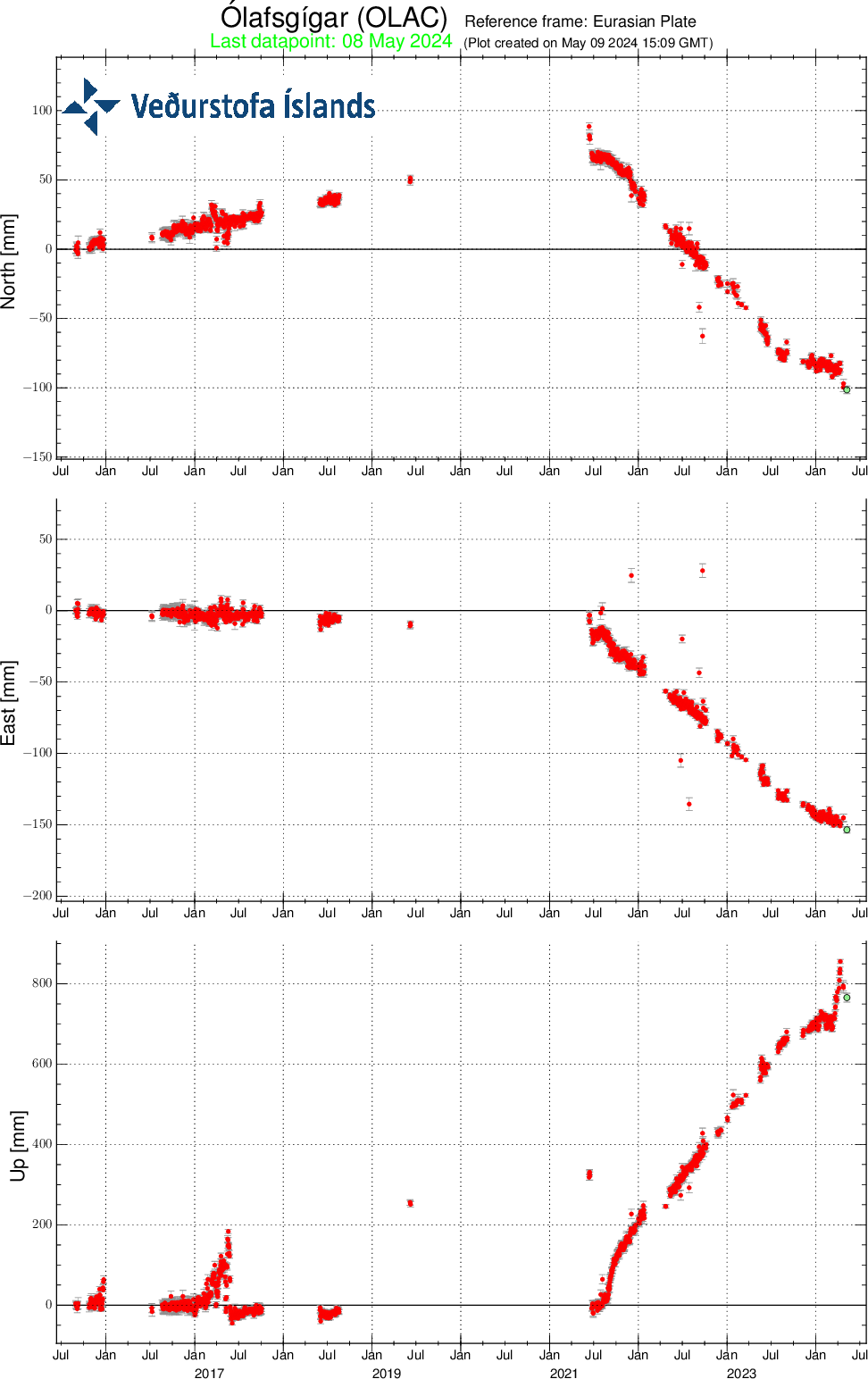
The change at Askja coincided with a change in Bardarbunga (KISA station) towards more GPS movements to N and W. Is there a negative relation between Askja and Bardarbunga?
looks like HVO has returned SDH Tiltmeter to service.
90% chance for the formation of a tropical Depression / Storm / Hurricane close to Hawaii during next 7 days: https://www.nhc.noaa.gov/gtwo.php?basin=cpac&fdays=7
It may cause a lahar-like erosion, if it hits the tephra layers of Kilauea in Kau desert.
A series of mega-Winter storms hit Hawaii in March that dropped 5+ feet of rain on parts of Oahu and a couple feet of rain and feet of snow (over Mauna Loa and Mauna Kea) over the Big Island when power to Kilauea was K.O.’d for weeks.
Didn’t hear of any lahars or similar ground deformation (landslides, etc), though.
But, a lot of water did fall on Kaluapele and Halemaʻumaʻu, and being in a bowl that captured a lot of extra rainwater, one must wonder if it had any impact on the current eruption sequence…perhaps by cooling the upper crust and making it more brittle than ductile?
From USGS
5.0
16 km W of San José del Palmar, Colombia
2026-08-10 09:18:10 (UTC-04:00)
98.5 km
7.4
5 km S of San José del Palmar, Colombia
2026-08-10 08:34:28 (UTC-04:00)
110.3 km
From AP news
BOGOTA, Colombia (AP) — At least two people were killed and dozens of buildings collapsed in cities across western Colombia on Monday after a powerful 7.4-magnitude earthquake struck the South American nation, trapping residents under debris, leaving more injured and forcing people to evacuate their homes as far as the capital of Bogotá.
The epicenter was in San Jose Del Palmar, a community of about 4,800 people in the Choco region about 250 miles (400 kilometers) west of Bogota, the U.S. Geological Survey and Colombia’s counterpart reported. The USGS said it struck at a depth of 66 miles (107 kilometers). The quake also was felt in neighboring Ecuador.
At 110km depth, an intraplate, oblique quake with such a strong strike-slip component is unusual. Such locales often feature folding events with normal or reverse faulting mechanisms dominating,
Also noting a distinct lack of aftershocks…just one, an M5.0 just to the west of the main shock.
When I read about the quake and depth I almost assumed it was on the descending slab. But with a strike slip component? How deep is the descending plate there, anyone know?
Two shallow earthquakes in Kilauea’s SWRZ – news or not news?
The largest quake had a 2.30 M at -0.48 km depth (480m above sea level) three hours ago.
HVO mentions a swarm of 18 earthquakes in the low SWRZ. https://www.bigislandvideonews.com/2026/08/10/kilauea-volcano-update-southwest-rift-zone-earthquakes-increase/
The location is between the lava flow tongues of 1919 and the eruption vents 1823. Did the swarm occur on the Kamakaia dike swarm of SWRZ? https://www.volcanocafe.org/kilaueas-triple-swrz/
Just got to looking around at instruments again. It looks like they also have brought a lot of GPS stations online again. I have not looked at all of them.
Puracé volcano erupted one day after the 7.4 eq in Colombia. It has been showing signs of unrest for a while, however one kick was enough for it to go. It has happened before but there is no proof of such relationship whatsoever.
That is interesting. Major earthquakes can apparently do this
Tomorrow Reykjavik will have its first total solar eclipse for 600 years. I hope it won’t be cloudy
Great pictures from Iceland and from a cruiseship near Greenland.
I wonder whether this is about right, find it quite fascinating:
https://www.dailymail.com/sciencetech/article-16046795/Scientists-discover-black-hole-star.html
Kamaʻehuakanaloa volcano (formerly Lōʻihi) is having a decent earthquake swarm. Latest quake was a 5.2.
Latest congo space images
Nyiramuragiras lava lake remains strong with a gigantic dome fountain upwelling in the southen part, visible and thermal imagery sulfur emissions are about 14 000 tons a day I think
https://browser.dataspace.copernicus.eu/?zoom=16&lat=-1.41037&lng=29.20713&themeId=DEFAULT-THEME&visualizationUrl=U2FsdGVkX19e8L8XGoqKnuaCHkJxFQf6%2FdRhijnhC%2FtJlhckglE9fADT4wO71HKIs2SMuSCEFV%2FlONnZ2nCUjHi9IsmX3xeNWPljixGY4gomfe%2FDJFTd3KYxdzjWvzPH&datasetId=S2_L2A_CDAS&fromTime=2026-08-11T00%3A00%3A00.000Z&toTime=2026-08-11T23%3A59%3A59.999Z&layerId=1_TRUE_COLOR&demSource3D=%22MAPZEN%22&cloudCoverage=30&dateMode=SINGLE
https://browser.dataspace.copernicus.eu/?zoom=16&lat=-1.41037&lng=29.20713&themeId=DEFAULT-THEME&visualizationUrl=U2FsdGVkX1%2FnYdbvrOWJm89gPh6MCD5un6pPxq%2FZMo4WXg4W2dTGsSUCB1AkLgCtKFzIWucIMMdVHCHB5WHitunVczXabnMdPIzBZ8pxcf3jQqy62cYHVPdnwm%2BmWqBe&datasetId=S2_L2A_CDAS&fromTime=2026-08-11T00%3A00%3A00.000Z&toTime=2026-08-11T23%3A59%3A59.999Z&layerId=6-SWIR&demSource3D=%22MAPZEN%22&cloudCoverage=30&dateMode=SINGLE
Nyiragongo hosts a much smaller 60 meters wide lava lake inside a spatter cone the lava level have risen about 400 meters since it was drained in 2021 eruption. Sulfur emissions are about 6000 tons per day
https://browser.dataspace.copernicus.eu/?zoom=16&lat=-1.52224&lng=29.25211&themeId=DEFAULT-THEME&visualizationUrl=U2FsdGVkX1%2BGN7MGdMDRfJ6ZMlYg1fi77Ubd71gpVJqao0J4fnvvcA%2Fh3JZMCl0SWp%2Bj3Ibu3%2FB05EUCvRz2AUZRVVw%2BeW8fhyR8ocsCbj6Rih5Vk%2Fo6qNI293NZ7z45&datasetId=S2_L2A_CDAS&fromTime=2026-08-11T00%3A00%3A00.000Z&toTime=2026-08-11T23%3A59%3A59.999Z&layerId=6-SWIR&demSource3D=%22MAPZEN%22&cloudCoverage=30&dateMode=SINGLE
Kilauea has started the ‘I’ part of the long DI event. It started just before the M5 earthquake so that quake was not the trigger. The progress towards the next episode could now go quite quickly
The new third vent above the south vent currently seems to be more active than the south vent. It will be interesting to see what happens to it during the eruption.
Impressive footage of Etnas eruption and lavaflow:
A tropical storm may impact Kilauea in a few days. I was wondering about the fountaining and storm occurring simultaneously but it seems likely that the episode will occur before that.
The Tropical Storm is scheduled for Friday. It “is too soon to specify the exact location and magnitude
of impacts”. I’d expect that this will be one day after E53 … maybe with a pretty steam firework in the caldera.
https://www.nhc.noaa.gov/text/refresh/HFOTCDCP2+shtml/121502.shtml
Now they predict the impact of the Tropical Storm on Big Island on Saturday 8 am HST that’s Friday 10 pm UTC:
https://www.nhc.noaa.gov/refresh/graphics_cp2+shtml/130840.shtml?cone#contents

Big Island can limit the development of the Tropical Storm: “near Hawaii, the environment should become somewhat less favorable due to some southwesterly shear, interaction with the island of Hawaii, and dry air entrainment. These conditions are likely to slow or stop intensification.” Although the intensity of the storm is still uncertain, it is certain that heavy rain will occur with “life-threatening flooding and mudslides”. https://www.nhc.noaa.gov/text/refresh/HFOTCDCP2+shtml/130841.shtml?
8am HST on Saturday should be 6pm UTC, also Saturday
Sorry 😉 wrong calculation
M5.2 southeast of Kilauea.
M 5.2 – 42 km ESE of Naalehu, Hawaii (USGS, 12Aug)
I wonder when Hawaii will get a new island?
In about 100,000 years or so.
I think it’s rather the question: when and how will Loihi erupt again?
North and south vents are overflowing now.
And we’re off! Episode 53 is officially on.
V3 webcam us getting pounded. Lava is visible from both vents (on/off) and the crack in the crater wall. Definitely more robust than the last few episodes. Spectacular fountaining,
V3 also shows the third vent on a higher elevation that predominantly releases steam and gas: https://www.youtube.com/watch?v=gXKuUyKt8mc
The eruption has lasted for 12 hours now. The episode is relatively long compared to some episodes before. It is the first episode 2026 to last so long. The last 12 hours episode was in December 2025. The peak height of the lava fountain was 150m.
Nice view from Mauna Loa’s road:
The total tilt change is still within normal range, and seems to have dropped slower than in the past few episodes. The eruption rate may be a bit lower than recently
Kilauea’s intra-caldera shield volcano now has officially a third vent: They call it “the new west vent (formerly the collapse pit)”. It mainly did Hydrogen flames during the E53 or E-LIII as Roman numerals. The west vent also did some lava overflows.
Volume of E-LIII: 4.6 million cubic meters
Peak height of the lava fountain: 150 meters
Tephra Plume height: 5,500 meters
Area of E53: lava flows that cover about 40-50% of the floor of Halemaʻumaʻu crater
https://volcanoes.usgs.gov/hans-public/notice/DOI-USGS-HVO-2026-08-13T11:52:10+00:00
This video shows in minute 1:00 the new third vent called the “west vent” with lava overflows during E53: https://www.youtube.com/watch?v=ulsGe3CyUPw
FWIW, just made a movie of several Perseids I photo’d over the last 4 days.
The fireball at the end was spectacular…so bright it hurt my eyes. The smoke trail persisted for close to minute.
https://youtu.be/Wlpt-yAv5HY
https://www.ct.ingv.it/index.php/monitoraggio-e-sorveglianza/segnali-in-tempo-reale/video-sorveglianza-vulcanica-etna
Etna keeps doing its thing
Here you can watch Etna live: https://www.youtube.com/watch?v=t4vlFU-ypIw
Meanwhile Big Island (Hawaii) has got a Hurricane Warning for Saturday: https://bigislandnow.com/2026/08/13/thursday-weather-update-hurricane-warning-issued-for-big-island-as-lala-continues-march-toward-state/
They expect that Hurricane Lala will bring…
– winds of up to 110 mph
– rainfall in general “8 to 12 inches … with maximum totals of 25 inches possible on the Big Island.”
The impact from the east means, that Kilauea will be the first part of the State of Hawaii to be hit and to get the hardest rain. 10 inches apply to 200mm or 200 liter per m², but it may be 20 inches with incredible 400mm:
I met a very interesting American lady who grew up in Dominica.
So I decided to read up about the geology of Dominica. Abstract, abstract, abstract, partially old.
Well I think, let’s look up VC, and I find a very interesting piece by good old reliable Albert, no surprize here. Thank you and kudos:
https://www.volcanocafe.org/the-caribbean-paradise/
From the reasons for the Caribbean plateau I prefer the second:
“The other model places it as originally part of the Pacific ocean. This second model is now seen as most likely. The CLIP deposits are one of the reasons for this. The isotopic composition of the lavas and the age indicate a possible relation to the Galapagos hot spot – and this has always been in the Pacific ocean. The basalts must have drifted with the Pacific ocean floor towards the east.”
It makes me think of 1) Hikurangu and 2) Manihiki that are older (by ~30 million years) than the CLIP, but supposed to have been part of the Ontong Java Plateau and broken off and travelled and also supposed to habe been born by a mantle plume.
This mantle plume is deceased, but the Galapagos Mantle Plume is still there.
So I can easily see the same mechanism here, travelling involved, and, as you describe in the piece there was still a large opening between N- and S-America.
http://www.decadevolcano.net/photos/nyiragongo_july06_01.htm
Past photos from Nyiragongos 2003 – 2021 lava lake. I loves how strange Nyiragongos nephelinite lava lakes looks like compared to normal basaltic lava lakes. But Kilauea can look like this when the lava surface is disturbed but on Nyiragongo it was the steady state look
7.7 earthquake off the northern coast of Flores, Indonesia.
https://earthquake.usgs.gov/earthquakes/eventpage/us6000tkt2/executive
Fortunately, only a minor tsunami reported (so far).
Was doing my final Perseids meteor watching session early this a.m., when I saw a beam of light in two distinct pulses coming from over the NE horizon. The light beam nearly reached overhead, so it was nearly 90 deg long from my vantage point in the northern Sacramento Valley. There were strong thunderstorms earlier, and I dismissed the flashes as distant lightning.
It turns out a huge bolide had exploded over NE Washington at the samet time, with the infrasound pressure wave showing up on many Cascadian volcano seismographs. Pretty cool to see such an event…but another 500 miles further south, I could;ve seen the meteor of a lifetime!
From the USGS (and also check the AMS site for more info):
“It’s a bird, it’s a plane, it’s a… bolide?
A bolide (large meteor) was observed in Washington State in the early morning hours of August 14. In addition to several eyewitness videos and disturbed pets, our infrasound instruments at several volcanoes recorded the bolide quite well. Infrasound refers to sound waves that are below the sensitivity of human hearing. Bolides are excellent infrasound generators because of their supersonic speed and fragmentation as they enter the atmosphere. Though dramatic to observe, bolides are common with thousands entering our global atmosphere daily.
This infographic shows what the infrasound signal looked like at each volcano. Look how different the signal is from volcano to volcano, what do you think it means? What could a scientist observe from this data?”
Here’s the USGS link to see what the meteor explosion looked like on the seismo’s.
https://www.facebook.com/USGSVolcanoes
Thats stuff shed from Swift Tuttle cometary core: an object you wants as far away from Earth as possible : O
Kilauea will get up to 635mm of rain, that applies to > 0.6 m³ per m². Can it create a temporary lake in the caldera?
The caldera is too hot to make a lake that way, the fresh empty caldera in 2018 was hit by a hurricane with hust as much rain as this one twice in the first year and neither storm could quench the heat at all…
It’s possible Lala could drop 2x (or more) than in 2018 if her track takes it over the southern tip of the Big Island. Some progs are calling for maybe 25″ over the mountains due to enhanced orographic effects..of which Kilauea would be on the upslope.
I would still be surprised if water can stand on the porous and hot floor though. Only a few meters down its over 1000 C, tens of meters at most.
Here we can see the volcanic cooking plate in the caldera:
The hurricane will likely disturb the monitoring data and let us be blind for some days. Radar image:
Officially a hurricane now
000
WTPA62 PHFO 151955
TCUCP2
Hurricane Lala Tropical Cyclone Update
NWS Central Pacific Hurricane Center Honolulu HI CP012026
Issued by NWS National Hurricane Center Miami FL
1000 AM HST Sat Aug 15 2026
…LALA CONTINUES ITS APPROACH TOWARD THE BIG ISLAND OF HAWAII
BRINGING GUSTY WINDS AND HEAVY RAINFALL…
…1000 AM HST (2000 UTC) POSITION UPDATE…
A sustained wind of 41 mph (66 km/h) and a gust of 64 mph (102
km/h) was recently reported at an observation site near South
Point around 550 feet elevation.
SUMMARY OF 1000 AM HST…2000 UTC…INFORMATION
———————————————-
LOCATION…18.0N 155.2W
ABOUT 75 MI…120 KM SSE OF SOUTH POINT HAWAII
ABOUT 290 MI…465 KM SE OF HONOLULU HAWAII
MAXIMUM SUSTAINED WINDS…75 MPH…120 KM/H
PRESENT MOVEMENT…WNW OR 290 DEGREES AT 9 MPH…15 KM/H
MINIMUM CENTRAL PRESSURE…988 MB…29.18 INCHES
$$
Forecaster Pierce/Cangialosi
M6.9 near Lake Toba
I came here to post that. Looks like it is on the great Sumatran fault?
https://earthquake.usgs.gov/earthquakes/eventpage/us6000tkyk/executive
Keep an eye on Sinabung. Or Toba, I suppose.
Latest sate shot of Nyiramuragiras lava lake the caldera is almost completely filled by pahoehoe
https://browser.dataspace.copernicus.eu/?zoom=15&lat=-1.41164&lng=29.20771&themeId=DEFAULT-THEME&visualizationUrl=U2FsdGVkX1%2FiObwyaN71FhVWPJ2sxex4rl0O1JRV0O5IWSnCodDbBYQRAuM46emZYrGCKcpvHAJOFIChBM1yrV0nrqi6Gw1SMiTBL5VpSTKK28JZkHBBKoJCrCmuauYK&datasetId=S2_L2A_CDAS&fromTime=2026-08-14T00%3A00%3A00.000Z&toTime=2026-08-14T23%3A59%3A59.999Z&layerId=1_TRUE_COLOR&demSource3D=%22MAPZEN%22&cloudCoverage=30&dateMode=SINGLE
A new tube feed pahoehoe is moving down Nyiramuragiras south side it may flow for 10 km before it stops
https://browser.dataspace.copernicus.eu/?zoom=14&lat=-1.41905&lng=29.20458&themeId=DEFAULT-THEME&visualizationUrl=U2FsdGVkX1%2BbOYYdMzEWCc1YAiL8vBKM%2F2h6EQSUDxJb3ANe17Pm9GZIcZATQl%2Fs08X19lXgj%2FOUhyfARntMp0kXqtX4MCfkxDILW5Um%2B%2Fc8xh4y9VcK97ksDwd6PF6F&datasetId=S2_L2A_CDAS&fromTime=2026-08-14T00%3A00%3A00.000Z&toTime=2026-08-14T23%3A59%3A59.999Z&layerId=6-SWIR&demSource3D=%22MAPZEN%22&cloudCoverage=30&dateMode=SINGLE
Nyiragongo hosts an active lava lake too
https://browser.dataspace.copernicus.eu/?zoom=15&lat=-1.52024&lng=29.25093&themeId=DEFAULT-THEME&visualizationUrl=U2FsdGVkX1%2BZVApTBXlNSy2QCkfx%2FttoQKtIO36zGXZU%2B2pdOLmeaq8LXkSLlF7UFd2NCq4%2F%2BSu5ibGRzeTHgvnvXnyldtKw3%2FsUpMa07mQwuyr4KBxKBVJO%2FDoDQ547&datasetId=S2_L2A_CDAS&fromTime=2026-08-14T00%3A00%3A00.000Z&toTime=2026-08-14T23%3A59%3A59.999Z&layerId=3-WILDFIRES&demSource3D=%22MAPZEN%22&cloudCoverage=30&dateMode=SINGLE
Askja is officially back on alert level 0 (normal background conditions): https://en.vedur.is/about-imo/news/measurements-show-that-uplift-at-askja-has-ceased
Nearing 3 feet of rain over orographically favored terrain on the southern tip of the Big Island. I suspect Kilauea’s recent lava layer layer (~ 50% of the crater floor got covered from episode 53) got a good cooling-off. Will be interesting to see the crater in the morning light for signs of landslides or collapses of any of the vent walls?
We might expect dense fog for some time while that water boils off! The ash around the vents may have slid down quite a bit. Guessing, of course.
The tilt shows a rain effect of 4 mirrored
Just checking some news reports from the big Island. It looks like the southern tip of the Big island is cutoff from just north of Pahala on Highway 11. There are also reports that the area is also cut off from the west side. Only accessible via helicopter as of now.
KHON2 news
This is from the Waiohino town, south and west of Pahala
“Massive devastation from the torrential rain of Hurricane Lala in the community of Waiʻōhinu (Waiohinu), which is located near the southernmost part of the Big Island of Hawaii.
Professional Meteorologist and Hurricane Chaser Simon Brewer reports from the scene with the graphic aftermath of the flooding that cut out new waterfalls and river channels into Highway 11 and cut off Waiʻōhinu from the rest of the island.
Lala has a chance to become a taifun, if it crosses the international date line on 180°W/E:
Found this report while looking at the news
Volcano Watch: Using ocean noise to monitor for volcanic eruptions.
“https://www.westhawaiitoday.com/2026/08/15/hawaii-news/volcano-update/volcano-watch-using-ocean-noise-to-monitor-for-volcanic-eruptions/”
“Ocean swells are constantly beating on the ocean floor. This nonstop drumming creates continuous signals that travel through the Earth and are recorded on seismometers. Changes in the speed of these ocean noise signals can give us clues about volcanic activity.
Many years ago there was a similar article about how wave action from Hurricane Sandy was detected by seismograms all the way to California. But, IIRC there was no mention of how the detection process could help identify volcanism.
You don’t need a hurricane for that. Waves hitting the coast cause seismic noise all the time. It is part of the noise affecting telescope which detect oscillations in the Sun, and LIGO also sees this noise
Indeed. I was just referring to one of the more notable media tid-bits.
We (VC) gave ourselves a good education watching El Hierro with the different types of “tremor”, IIRC.
Iceland too.
damp Kilauea
Yellowstone’s last supereruption was much more complicated than thought. Turns out there is only one resurgent dome after all.
https://www.usgs.gov/observatories/yvo/news/expanded-understanding-lava-creek-tuff-eruption
Hi Folks,
Long time lurker seldom poster.
Question, taking etna as example, assuming maga taking open conduit from dept. How long does it take to erupt during an actual eruption? What’s its origin and how long to become lava. Assume happy path, non storage in the mountain.
Also I would welcome thoughts on etna likely volcano behaviour in near future as im planning a trip.
Richie
Think someone said 2months was fastest expected from leaving depth to the surface during the el hierro. But that is purely from memory might be completely wrong.
The fastest type of eruption is kimberlite. This is driven by CO2 and can come from 100-200 km depth to the surface in 24 hours. This has never been observed as this type of eruption is so rare. It corresponds to a few meters per second ascend speed.
For an open, filled conduit the eruption rate may be 10 m3/s. For a conduit diameter of a few meter, that requires a vertical velocity of 1 m/s. So from a few kilometres depth to the surface can take as little as an hour. A fountaining eruption goes much faster near the surface (exit speeds can be 100 m/s) but that is only near the top. I think dikes form at similar speed. And during the 2018 Kilauea eruption, the collapses at the crater were followed by increased eruption rates a few hours later, perhaps 30 km away. That is a speed of 2-3 m/s.
In the build-up to an eruption, the conduit will fill up much more slowly.