This post was published by the author at
https://peakbook.org/Þróndeimr/tour/437021/Vulkanutbrudd+på+La+Palma.html, and is reproduced and translated) here by kind permission by the author.
Volcanoes have fascinated me since I was little but it was not until the eruption on Eyjafjallajökull in 2010 that I looked at the possibilities and began to reflect on the idea of going to watch an ongoing volcanic eruption. Until now, I had considered Iceland as the most likely destination for seeing an eruption. Iceland is nearby and many of the outbreaks there last a long time, which I need to find the time and to have the opportunity to travel there. Then the volcano must be of a small size. An ashy eruption would close the airspace for flights and such eruptions are usually short and intense. That it became a trip to the charter destination of the Canary Islands came as a surprise to myself as well.

This is for several reasons. The volcanoes in the Canary Islands mostly offer fairly stable small eruptions, but they happen so rarely that I had not listed them as a probable place to see a volcanic eruption. At La Palma, for example, a volcanic eruption occurs about every 50-90 years; the eruptions have a duration of between about 20 and 90 days if you look at the previous six historical eruptions. Teide / Tenerife sees 4-6 eruptions over a thousand years, i.e. much less frequently. Lanzarote sees large eruptions in a series which last a long time, but perhaps as infrequently as 2-4 times per thousand years.
Earlier this year, such a “tourist volcano” started in Iceland. Fagradalsfjall Volcano is perhaps the perfect tourist volcano and with Iceland’s policy around this, quite extensive measures were initiated to secure the surrounding areas so that 50,000 tourists could see it up close every week. Unfortunately it had to happen in the middle of the pandemic, so I was unable to go there. And now that the country is reopening, the volcano in Iceland has gone a bit into sleep mode.
Then the volcano Cumbre Vieja on La Palma appeared, just before the reopening at the end of September. I found fantastic cheap airline tickets, so I dropped all plans and some duties I had agreed to, in order to hop on the plane to the disaster area in the Canary Islands. To make sure I would be able to reach the island, I first booked flights to Tenerife. I had planned out the journey ahead but did not book anything until I had landed on Tenerife. The reason for this was that so much was unpredictable, not only in relation to traveling to La Palma during a volcanic eruption, but also at the airports in relation to the pandemic. I had a stopover in Naples, i.e. in a ‘yellow’ country (Italy). The Canary Islands were also ‘yellow’ while Spain was ‘red’. During phase 1 of the reopening only ‘green’ and ‘yellow’ countries were exempt from quarantine upon return to Norway.
When the plane landed on Tenerife after pandemic delays through chaotic conditions in Naples, I had 40 minutes to take a taxi from the airport down to the port and get on a boat to La Palma. The boat was covered in ash from the volcanic eruption at La Palma, a clear step towards the destination! While on the ferry, I booked an overnight box room in an old building in the capital Santa Cruz de la Palma to sleep in, for NOK 200 a night, something I had not tried before and was really excellent!
The Cumbre Vieja volcano on La Palma is a strombolian volcano. Such eruptions are small and stable, reaching 1-2 on the VEI scale (which runs from 0 to 8). The current eruption is VEI 2, with typical tall lava columns and occasionally some ash. It is rare for such volcanoes to produce so much ash that it causes significant problems farther away, but they can produce sulfur dioxide (SO2) and other important volcanic gases.
On La Palma I rented a car and spent the night in the island’s largest city, Santa Cruz de La Palma. The city is located on the east side of the island, sheltered from the eruption which is on the west side of the island. From where I was it was about a 30min drive to the eruption. A marked area around the volcano was closed down. The map can be seen under the Risk Assessment at the bottom of this report.

The first trip into the area was already fascinating. I drove the rental car along some narrow, local roads east of El Paso. The roads were covered with 2-3cm of ash, very interesting to drive on! I parked the car and made my way through the woods to a ridge from where there was a view of the eruption. The risk assessment at the bottom of the report describes which assessments I took before going there. The massive sound from the eruption, as well as two small earthquakes made the experience a powerful one. This was the first trip and in a bit of a hurry I had not immersed myself too much in the up-to-date information from the geologists in the area. I turned back a lot earlier than I could have done.
At this time, the volcano had built up an approximately 70m high volcanic cone. An ash-rich cloud rose from the cone, while on the northwest side of the cone lava erupted from a side valve. The lava that flooded out there looked almost Hawaiian, not strombolian.


To get a better overview of the area and the volcano, I took a trip to Pico Bejenado, a peak of 1852m just 8km north of the eruption. Up to this time, the volcano had ben active from two location. On this day, the main crater erupted a thick and dark cloud of ash rising 6100m into the atmosphere, before falling down again. But lava erupted from the west side of the crater, shown in the pictures above. This lava flowed straight into the cities below and was on its way to the sea.

While I went up, there was a change in the volcano. I felt two new earthquakes. Both were short, around 2-3 seconds and measured 2.9 and 3.1. I had never experienced an earthquake before, so I must say I thought it was very exciting every time. Not long after, the pattern of the eruption changed. As you can see in the pictures below, the main crater went from being in a stable ash eruption to exhibiting pure lava columns, in a more explosive form than those of the side vent. It was a typical strombolian eruption pattern. During this trip the lava reached the Atlantic Ocean and a toxic cloud settled like a lid over the entire area, which you see in one picture further down. This fog disappeared later in the evening when the wind dispersed it.


After the trip up Pico Bejendado it was late at night, but I still wanted to drive to the barricades to see the spectacle up close. I, like many others, stood by the barriers about 1900m from the eruption to look at the lava columns that stood 800m up. Seeing something like this from the streets of the city while it is being destroyed is something I probably will never forget. Something significant is still missing from this report and that is the sound of the volcano. The massive and roaring sound makes it almost impossible to talk to the others near you. It can be compared to a fighter plane taking off, only that it takes off constantly!


I slept for no more than 3 hours through the night, no time to sleep any more! I Went out again and observed the volcano from an area in the northwest, near the town of La Punta. The big challenge on that day was that the wind was very strong from the northeast. The falling ash blew around the island and made it uncomfortable everywhere. Around 70% of the island had been covered by various amounts of ash during the previous days. Inhaling ash was annoying but not much worse: the ash particles from this volcano are so large that they do not go down into the lungs (important with lots of nose hair!) But they irritate the eyes quite a lot. Glasses made it hurt worse when turbulence between the glasses propelled the ash particles into the eye. In advance, I bought a cleaner in relation to such particles.
It was thus set for a day with some distance from the areas closest to the eruption, at least for the first hours while the wind was strongest. From the vantage point above La Punta, I could see the lava flowing into the ocean and the chemical process that occurs when the lava meets water and turns into corrosive clouds. An hour after I sat down on the observation post, the volcano changed its eruption pattern again to a more ash-rich eruption from the main crater.


After a few quiet hours at the observation post in the sun, the trip took me to La Palma’s highest peak, Roque de los Muchachos with its 2426m. From here, of course, the eruption was clearly visible!

Then came the darkness and I wanted to take one last night trip and watch the eruption before my journey continued the next day. The wind still blew from the east / northeast, as strong as before with 15-20 m/s. But now it had been blowing for so long that most of the ashes that could be moved had been moved. With the constant wind direction and the stability of the eruption, it was vest to approach from the east, with the wind in the back while watching the eruption. I explored the terrain and for each ridge ahead there was a short stop to re-evaluate the framework and the risk. I was able to pinpoint an area just over 700m northeast of the volcano cone. The cone had changed a bit in character lately, it seemed to have started to sag in the west edge so that the lava columns also went further out, good of me who was on the east side since I had a good margin in relation to falling materials from the volcano. In the dark here I also met two German “volcanic tourists”. They were very secretive but wanted to get very close as they said. I never saw them again, so possible I was closer than them!


The strongest earthquake I felt was while parking the rental car in the parking basement at the airport. The earthquake measured only 3.1, but it felt more violent than the previous ones in that category. The quake lasted about 3 seconds, but all the cars vibrated, as did the pillars that held the airport up.

Risk assessment

Here I will make an attempt to convince you as a reader that I has made appropriate sensible assessments in relation to the three trips I made close to the outbreak. The map shows these three:
Trip no. 1. Distance from photo location to the eruption: 1900m
Trip no. 2. Distance from photo location to the eruption: 1500m
Trip no. 3. Distance from photo location to the eruption: 740m .
This is my first trip close to an ongoing volcanic eruption so the assessments were made accordingly. For many, it will probably seem headless to go as close as I have done, but I have written down the reviews I have made below. You get a somewhat misleading and frightening picture of the volcano in some media. I was more skeptical even when I went into the area before I saw the eruption, the terrain around, the weather and the wind and all the information from the official sources Involcan and Copernicus. Involcan had a very good information channel on Twitter with information and explanations. Copernicus added good maps and satellite images for good help. Wind and weather reports as well as satellite images and radar images, for which I like to use Windy where you can find webcams and the like. Live video was also posted on Youtube which could be checked when I myself did not see the eruption due to terrain obstacles while I was moving around. Yr also works quite well abroad and provides more accurate weather forecasts than any other service.

Trip 1: This trip was only a few hours after the lava reached the sea and high values of sulfur dioxide and hydrogen sulfide were measured in the area by the sea and up to the area I went into. I was actually going to drive back to the hotel after the trip up to Pico Bejenado , but quite suddenly the wind increased considerably from the east / northeast. It matched well with the wind message and satellite images of Windy and I could see that all the haze and fog that lay like a lid over the cities west of the eruption blew away. Driving down to El Paso, some low haze between the buildings was blown at full speed towards the sea. I drove through one scch fog and it smelled like a thousand rotten eggs. The air became clearer and I drove to the roadblock in the street in question. The roadblock is about 3km away from the eruption, but from there you can enter a new barrier that is manned closer to the eruption (1900m from the eruption). The biggest challenge with the trip was that the wind started to blow up so much that the volcanic ash started to drift with turbulence around the streets. Many other people showed up at the barricades to take pictures.

The distance to the eruption of close to 2km seemed good and that is probably why they have set the barriers here. All the ash and gas from the eruption itself and the lava flows blew in a safe direction at sea. The lava columns were up to 600-800m in height and threw the lava 200-300m out to the sides. A possible risk apart from lava, axis and gas is that the volcanic cone becomes unstable as it grows and slides down on the western edge as it is constructed on a steep slope. It can trigger landslides of hot pumice, ash and lava that can reach a few hundred meters beyond the terrain at the western edge of the eruption. The pressure from the volcano can blow the mass further out to the west, northwest and southwest depending on how the rift is constructed. The volcano was quite fierce when I was here, with lava columns that stood 600-800m up. GPS track from tour no. 1: Approach 3.
Trip 2: The trip went towards the eruption during the day. The wind direction went from west to east, so I approached from the north. There wasn’t much wind so I was tried to keep to the ridges where air quality was best. At this point I did not know exactly how much gas was coming out so I could not assess it well. Therefore I added some margin and kept my distance and stayed where there was some wind. The area had a good shower of ash from the day before, and there was warm ash on the ground, up to 15-20cm where I stopped (1500m from the eruption). I observed many different birds both high above the ridges and down in the depressions beyond (positive in relation to air quality). This mountain side has an inclination of about 10-15 degrees towards the sea in the west, so it takes a lot for high values of gases to remain in this area. I stopped and observed the eruption from 1500m. It was tempting to walk 300m to the next ridge which is the last high marked ridge before the eruption, but notification of a change in wind by the end of the day meant that I wanted to keep the margins while I still did not feel I had one hundred percent control over all risk factors. At this time, the ash cloud from the volcano rose 6100m into the atmosphere. Lava bombs and such materials were thrown up to 600-800m from the crater and up to 300m out of the crater. After the trip, I read the latest report on the gas measurements in the last few days, which gave me more leeway on trip 3.
A little more about gas: Usually SO2 (Sulfur Dioxide) is the biggest challenge in a volcanic eruption. The gas is colorless, but a small amount of it will smell strongly, with a kind of rotten egg so it is easy to detect. The gas, on the other hand, can mix with moisture and come down as acid rain (sulfuric acid), then it will be able to cause damage to the skin and eyes mainly as long as it is not inhaled in a way. InVolcan measured 7,000-11,000 tons of SO2 per day in the days before the lava reached the ocean, a modest value. By comparison, Pinatubo emitted 20 million tons of SO2 over a few days in 1991. A volcano in Iceland emitted 120 million tons of SO2 that killed tens of thousands in northern Europe in the 18th century. Kīlauea in Hawaii also erupted the day after I went on this trip: it spewed out 80,000 tons of SO2 per day for the first two days which can present health challenges if you have asthma or other respiratory challenges.
CO2 (Carbon dioxide) can also come in large quantities from volcanoes, it is both colorless and odorless and difficult to detect without measuring instruments. Fortunately, CO2 is easily transported away by wind and pressure from the volcano so it usually goes straight to the higher layers of the atmosphere. H2S (Hydrogen Sulfide) also occurs and is perhaps one of the more dangerous gases from a volcano as I have understood it. It is formed when sulfur from the magma reacts with water and is often a challenge in volcanoes that are close to lakes, have a large lake in the crater or are connected to large amounts of groundwater. Water is something La Palma is in short supply, both groundwater and lakes are absent from the island. InVolcan did not mention any hydrogen sulphide in its report on the measurements made. Otherwise, different gases are formed when the lava burns through various organic plants, houses, buildings and materials. The gases are easily carried by wind. GPS-Track from trip no. 2: Approach 2.

Trip 3: The wind that had started the day before had blown strongly throughout the day. Strong wind, 15-20m / s from northeast to southwest was blowing ash and gas to the sea. The biggest challenge was all the ash that blew around. The residents down in El Paso had to walk around with goggles. In the media, there was a lot of attention about the dangerous gases that occur and it probably scared those who read it. From InVolcan, which publishes the official information, very few dangerous gases are measured and those living on La Palma are reassured. There was talk of the formation of larger amounts of hydrogen sulphide down by the coast where the lava flowed into the sea and this formed some fog that was corrosive, but not a danger to those who lived on land even though at one point they were encouraged to stay inside one village near the harbor. Involcan had a boat standing close by at all times and never measured high values of H2S while I was on the island. In any case, this was not a real threat at the altitude I was at (600-1300 masl). There has also been increasing earthquake activity throughout the day and some hobby geologists and fans presented the idea that a new and larger crack could soon open some kilometers south of the eruption. The media bought this and some drama unfolded online. This was written off as a probability from an official standpoint with good and logical counter-arguments a few hours later.
When starting the trip I had no goal of where I could get to. I was looking for a safe area with a good overview, preferably with a canopy north or east of the eruption. There are fairly steep mountain sides above the eruption, so if you want to stay safest closest to the eruption, it is from this angle with good wind direction. The eruption was a bit weaker than the day before with lava columns 300-400m high with some fountains and lava rocks up to 500m. Coming closer, I saw that the lava columns angled slightly to the west rather than straight up as yesterday, an advantage as no lava bombs or materials are fired more than around 50-100m east. I thought this might show a weakness in the volcanic cone, sagging on the west side is logical on a fairly steep slope going downhill to the west. This was confirmed two days later when it was expected that there would be a landslide to the west which could change the volcano’s behavior to some extent.
I got into an area just east of the volcano, with some canopy and with a lot of wind in the back, so much so that I had to search a little around to find shelter. Here I was also not completely alone and some geologists were taking pictures (they had driven up with an ATV). There were also traces from 5-10 others who most likely had been here through the day after the wind turned. From here I had a good overview, some 700m from the eruption, and at least 600m clearance of any falling material. Here the ash was the deepest of what I had walked on, between 30 and 50cm. I dug down a couple of places and found that it was quite warm (50-70c) even two days after it had fallen here. GPS-Track from trip no. 3: Approach 4.
So now I have become a volcanic tourist. Fortunately, that is a healthier tourist than the charter tourist!
Christian Nesset


Massive lava output, 17:29 on AFAR.
New vent? Have not watched in a while.
It has been sotted before I think, last night?
It is getting more serious now tbough, lots of lava pooring down.
Ha, yeah, spotted.
I saw this a day or two ago, there is a vent further north than #3 vent, but it opens up only when a lot of gas pressure is present on the north side, otherwise it stays shut?
17:54, start watching afar time stamp
The volcano has turn on “fury node”…… very efusive.
Not sure, but that has “The calm before the storm”, something has coming.
The tremor has none descend.
https://drive.google.com/file/d/1PQxCTvOVzNn9edynUVPVeCVzKFAcUW5u/view?usp=sharing shows a smoking vent on the middle right hand side of the cone up above the active lava flow area which needs to be carefully watched
The sucesive floodings, has reach to the north channel. :/ that can be very dangerous if some big reach to them.

Meanwhile, no more 4+ quakes yet.
“There are hundreds of millions of cubic meters of lava that are trying to get out”
José Mangas, Professor of Geology at the
@ULPGC
, states that the eruption is still very much alive.
A classic tortology
No. A classic oxymoron rather than tautology.
Lava has already been erupted, so by definition it can’t be “trying to get out”.
IGME videos
– The evening lava flodding.
https://www.youtube.com/watch?v=6cAUUy4LAfA
– Tacande zone lava report
A clearly moving and hot lava flow, nowhere near the vent if I’m correctly.
Whewww… that really doesn’t look exceptionally good :/
Reminds me a bit of the July 2021 floods in Europe. We also had flowing stuff everywhere where it shouldn’t flow.
It reminds me of the way the fires seem to have raged down the hills in Southern France.
So most, it reminds me of the laws of gravity 🙂
For some reason TV Canarias has had the camera fixed upon a small segment of the flowing lava for past 1 hr 8 mins (9:26 pm CET right now) I feel pacified now 😉
la palma youtube https://www.youtube.com/watch?v=M9i5um3talo is focused on the vents. it is very foggy and probably raining, giving it quite abstract feel. but seems there is enough m3 pumped out anyway
actually just got another flood event on the upper falls..
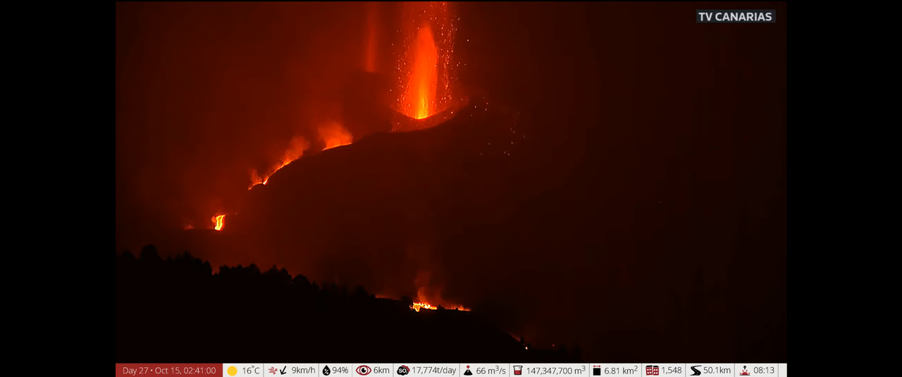
https://www.youtube.com/watch?v=INvrtMg5tSQ big load of yellow-orange hot lava descending the slope now at 10:26 pm CET
Another gusher around 12:09 am w
today one of our crew was able to film a truly lava “tsunami”. Amazing speed and overflow of the lava channel.
https://twitter.com/involcan/status/1448760790413193224
La Palma is blowing furiously right now! (2:40am local time). The rear visible vent gas jet may be reaching very high speeds – like a blow-torch. And fountaining from the front vent is enormous.
What a sight.
It almost looks like the top could blow off; there is so much pressure in there…
Picture:
I am getting real tired of Phivolcs B.S, a large area at Taal is inflating including the island, it doesn’t take much to post a graph or give more details than the most undescriptive statement possible. I actually have to browse third-party resources to obtain the most basic information concerning one of the most dangerous volcanoes on the planet. If I can get some GPS data for some of the least dangerous volcanoes on the planet like the tourist eruption in Iceland, I should get some for Taal.
https://comet.nerc.ac.uk/comet-volcano-portal/volcano-index/Philippines%20and%20SE%20Asia/Philippines/Taal/S1_analysis
The latest InSAR data I have found is 7 months old but it clearly shows the recent uplift in the system, the area of uplift is around 1,000 km2, there was a rapid increase in repressurization over a large area, and It looks like it’s still going on. Something is clearly keeping this volcano from releasing its pressure and magma is very close to the surface, something can easily go very wrong, very quickly. The only data that they are keeping us updated on is the seismic data. I don’t want any more excuses, this is beyond ridiculous.
Is it not possible for you to email/phone the appropriate department in Phivolcs and ask them to provide or update the information for you and doubtless many others both amateurs and professionals who are interested in the current and future behaviour of the volcano?
I have tried that but it didn’t go well.
Talk about a twisted one
I have looked at recent SAR data. There is no indication for strong inflation over the past few months. There is obviously activity, but not new magma
Could you share the link? I’d like to put this dog down for good
Around 5:10 am CET (or so) a massive flow of lava has been unleashed gushing down the cone, low viscosity lava, very hot and flowing rapidly down the slope. The vents seem to be repeating a pattern, the #3 goes gaseous, then quiets down, #2 gaseous, quiets down, then #3 kicks in again, and pretty soon a massive outpour from the new vent just north of #3 with lots of lava
That is just like the lava surges in iceland back in May, just no fountain. If the lava is like this from now on I think we should expect it to start breaking out of the sides of the cone or around the base.
https://www.ign.es/web/ultimos-terremotos/-/ultimos-terremotos/getDetails?evid=es2021ufagf&zona=1
Mag 4.5 quake and this gradual increase in magnitude is not welcomed
4.5 mbLg SW VILLA DE MAZO.ILP
2021/10/15 07:02:19IV
36
The volcano “delta” and the little valley exit continue filling. That has a very similar situations as Chad has talk. I think if the situation continue, That exit will be convert on a volcano flank on some weeks. Other point has be, that can get a propper better exit to the north, giving to the lava a channel to impact on more north zones over the hills.
The timelapse of “El time” show the floodings and the lava fills.
https://twitter.com/ElTimeLaPalma/status/1448908911734673421
The lava continue moving by the south flank of the La laguna montain, and has near to reach the sea and start to build a new fajana.
https://twitter.com/ElTimeLaPalma/status/1448946492476174336
4.1 mbLg SW VILLA DE MAZO.ILP
2021/10/15 10:48:31
S
38
Carmen López from
@IGNSpain
she explains that the deep seismicity is due to adjustments in magma reservoirs. Read full article at
@eldiarioes
https://twitter.com/VolcansCanarias/status/1448962340511232003
That’s what one would think. It has somehow to do with magma.
Carmen López:
https://elpais.com/ciencia/2021-09-20/la-erupcion-tienen-material-intensidad-y-magma-suficiente-para-aguantar-semanas.html
Translation, google (I hope it is mostly correct. She is a “she” not “he”, 4th line:
https://elpais-com.translate.goog/ciencia/2021-09-20/la-erupcion-tienen-material-intensidad-y-magma-suficiente-para-aguantar-semanas.html?_x_tr_sl=es&_x_tr_tl=en&_x_tr_hl=en&_x_tr_pto=nui,sc
The last statement is key:
The duration of the eruption will be controlled mainly by the emissions of sulfur dioxide.
It looks like one reliable key has been found by scientists to gauge a volcanic eruption.
One for Tallis,
From PHIVOLCS-DOST
“TAAL VOLCANO ADVISORY
15 October 2021
6:00 P.M.
This is a notice of anomalously high volcanic SO2 gas emission from Taal Volcano.
A total of 23,576 tonnes/day of volcanic sulfur dioxide or SO2 gas emission from the Taal Main Crater was recorded this morning, the second highest after Taal’s peak SO2 emission of 25,456 tonnes/day on 5 October 2021. SO2 flux this month has averaged 9,872 tonnes/day as the trend in average flux continues to increase since March 2021. Degassing at the Taal Main Crater, in addition, has been noticeably voluminous and generated steam-laden plumes as tall as 3,000 meters above the Taal Volcano Island or TVI. Thick vog observed over the Taal Caldera region can be expected to drift to the general north to west based on air parcel trajectory forecasts from PAGASA. Volcanic earthquake activity at Taal resumed on 11 October 2021 after a period of lull that began on 27 September 2021. A total 145 events consisting mostly of weak low-frequency earthquakes and volcanic tremor that are associated with magma and magmatic gas flow have been recorded since seismic activity resumed until 4:00 PM today. Lastly, a sudden inflation of TVI was detected by GPS monitoring in August 2021, consistent with renewed pressurization of the subsurface hydrothermal system due to continuous magmatic degassing.”
Source: https://www.phivolcs.dost.gov.ph/index.php/volcano-advisory-menu/13068-taal-volcano-advisory-15-october-2021-6-00-p-m?fbclid=IwAR1BWkXVIKyUwlYBqhjmzVa8nu1qBx1T0_avIyucmYpw7931BYcvuGGDLO4
An eruption like 2020 is definitely on the cards, hopefully they keep a close eye on the situation
I wouldn’t mind seeing a line graph or something that shows the SO2 levels over the past year to see how much it’s fluctuated etc, does anyone know if such as thing like this exists?
My goodness, slow, possibly too slow, but vastly improved technique,
I don’t know what these buildings are. I’m guessing they have something to do with the banana crop the island is famous for. The structures look like they have fabrik roofs so maybe the loss will be less by that. But the land is gone for many generations.
My idea is it’s a sort of foil for plants that they might also use in winter. It would protect the plants that are not hit by the lava directly from heat and smoke and might at least help to save the roots. But I don’t know, just an idea. It’s certainly agriculture as there are water reservoirs in between.
Greenhouses. Plastic. When they burn, they give of nasty dark smoke that is not good for your health. Plus any fertilizers and what’s needed when you grow bananas. This potentially hazardous smoke was another reason to evacuate people near the lava flows.
Ammonium nitrate is a commonly used fertilizer in agribusiness, and when it burns (or blows up) it specifically produces a reddish-brown cloud of NOx gases. So that brown nitrous cloud mentioned previously could well have been from ammonium nitrate meeting lava.
Another lava flow arriving to the sea
Big expansion to the north yesterday, not good.
https://twitter.com/defis_eu/status/1449037952827412495?s=20
https://www.canarianweekly.com/posts/lava-overflows-main-cone-la-laguna is about the overflow. On my Apple Iphone I can see the video of the huge flood of lava, but only a picture pops up on my desktop about this flood.
https://www.facebook.com/DiariodeAvisos/videos/1078217206251388/?t=15
this is amazingly huge flow
Something strange going on with the Canarian Weekly article in regard to time. The article quotes the earthquake occurring first in the morning, well, it did at 8:02:19 am CET time on Oct 15th [1] , and the article says that lava gushed out afterwards just after 2 pm (I assume Canarian time)
But the article is dated and posted Oct 14th 17:46:40 pm which is yesterday.
The original video is posted by Dario de Avisos yesterday Oct 14th with the words “La colada de lava en el cono principal se ha desbordado a las 14:15 horas, según informa el Instituto Volcanológico de Canarias (Involcan)” Google translate: The lava flow in the main cone has overflowed at 2:15 p.m., as reported by the Volcanological Institute of the Canary Islands (Involcan)” This facebook video is dated Oct 14th, 7:28 am according to my Mozilla browser.
Can anyone explain what is going on here? Why is the article and video dated yesterday Oct 14th, but the quake on Oct 15th, 8:02:19 am local Canarian time?
[1] http://www.ign.es/web/ign/portal/ultimos-terremotos/-/ultimos-terremotos/getDetails?evid=es2021ufagf&zona=1
Once La Laguna mountain southern slope has been crossed, the lava flow front advances between banana plantations with an average thickness of 7 meters
https://twitter.com/involcan/status/1449042021092675584
https://twitter.com/Radio_Luz_/status/1449050973914152971 posted 17:34 pm CET
Nitrogen dioxide clouds?
I think what is burning is a cool sistem, fridge or something like that… so it’s possible…
Fertilizer.
The last big earthquake (4.1) was 37km deep, today’s was 35km. It says there have been 28 at 30km depth or deeper and all have been sizeable. As we’ve seen with Kilauea, usually it’s a fresh batch tunneling up through a brittle lithosphere. I suspect this eruption has the pressure and supply to keep going for a fair while if it wants to.
I’m going to predict that it will end in December, because the flow rate is quite high. It’ll stop start before then though.
https://drive.google.com/file/d/1ypFoIGy7tQFpy6rhCoNmX9jOivf9qpyQ/view?usp=sharing is a digital snap that I took at 6:20:04 pm CET time, and I accentuated the photo so as to bring out the smoke. There is a tiny vent on the middle right hand side of the cone still smoking from yesterday and needs to be carefully watched as a breakout might be possible at this location.
[PS: I am sure that the local authorities ARE watching this very carefully]
Lava fountain on that spot…
Very strange. Right now you can’t see any glow, even though it is quite dark already. Is La Palma broken?
https://youtu.be/INvrtMg5tSQ
Seems OK to me (so far as erupting Canarian volcanoes go.).
Erupting but very voggy. Hard to see stuff.
Yes, now the glow is back. Are we in pulsating FAF mode already?
We are getting close to one month for this eruption. I wonder how that stacks up historically for previous eruptions. The Smithsonian site doesn’t elaborate.
INVOLCAN reporting a new vent.
https://twitter.com/involcan/status/1449084760656171013
The tweet has 150 likes already
So you saw it here first on Volcano Cafe!!! Another first!
Images of the new vent by El Time
https://twitter.com/ElTimeLaPalma/status/1449080835047661579
That can be a problem if start to eject lava. Can affect to the south zone.
https://twitter.com/VolcansCanarias/status/1449094909928091657
The Cumbre Vieja volcano just ejected an impressive plum! I tried an animation with some screenshots of the last 90 minutes. Source is the youtube webcam: Erupción volcánica en la isla de La Palma (Canarias) – Vista desde el Roque de los Muchachos. Hope it will show up.
*plume
Wow! Impressive. Thanks.
I think that was the new vent opening
This has gotten bigger, see the current picture at midnight Canarian time
I wonder if the inhabitants of the area will be able to breathe okay?
La Palma – Some numbers:
– Volume of lava emitted (as lava flows) up to 14/10/2021: 80 Mio m3
– Volume of Ash & Lapilli emitted up to 13/10/2021: 10 Mio m3
– Land covered with lava up to 15/10/2021: 732 hectares
– Maximal width of the lava field up to 14/10/2021: 1,770 m
– Rate of Sulfur dioxide ( 14/10/2021): 14,542 tons per day
– Buildings destroyed up to 15/10/2021: 1,817
– Roads destroyed up to 15/10/2021: 56.4 Km
– People evacuated: 7,000
Sources:
https://elapuron.com/noticias/sociedad/157007/las-coladas-la-laguna-tienden-confluir-una-sola-se-preve-lleguen-al-mar/
https://www.eltime.es/isla-bonita/35912-brutal-casi-10-millones-de-metros-cubicos-de-ceniza-y-lapilli-cubren-el-valle.html
https://www.eldiario.es/canariasahora/islas/copernicus-eleva-1-817-construcciones-arrasadas-lava-palma_1_8401111.html
Video of the new vent
https://twitter.com/VolcansCanarias/status/1449094909928091657
https://twitter.com/involcan/status/1449103436692299779
Thermographic image showing the anomaly generated by the new eruptive vent, yet to be confirmed if it’s a lava flow or pyroclastic fall
I did like the interview with the chief INVOLCAN scientist, who confirmed two fissures and 9 emission centers (love google translate) or vents. Is there any map which shows these 2 fissures and the vents accurately? I don’t think even Copernicus has this correct? (or am I wrong) The vent information has been needed from the start. I do remember chasing down videos and google earth and image pictures and interacive maps to locate where the first 5 or 6 vents got started as that information was almost impossible to find from the start despite all the pretty pictures of eruptive clouds mushrooming into the atmosphere.
This thing doesn’t want to calm down. Only four days to go where this will be going on for one month. I have no doubt it will keep going. Wondering if any volcanoholics know how long previous eruptions lasted.
One example: Research the Timanfaya event on Lanzarote in the 18th Century. It was La Palma on steroids. Then fly out there and tour the National Park. An eyeful!!
Yes Timanfaya is beyond belief.
To be honest I am getting very sad for the inhabitants, its now done excessive damage and no end in sight. That said in 20 years I am sure it will be a cash generation for the island.
Not at all the best outcome but something like this is very possible. The only eruption in the historical period of the Canary Islands to have a sustained eruption rate as high as we see now at Tajogaite was Caldera de los Cuervos at the start of the Timanfaya eruption sequence where a pocket of fluid lava under the island burst out, like a lava flood fissure but only a single vent was there. After a few months of that rifting happened and tholeiitic basalt erupted relatively slow for 6 years, faster than a lava shield but similar style, a lot like at Fagradalshraun. There needs to be a proper article on this here, the only one as far as I know is old and generally a bit dated for what we know today.
La Palma was maybe mostly inactive for a few thousand years until just before the historic period, since then it has been much more active, this eruption could end up being the grand finale dwarfing all the others.
Well unfortunately I won’t be flying there any time soon though I would love to see it. Me and flying don’t get along anymore. When I was younger I flew all over the place for work. That was then this is now. I’d rather drive but can’t drive there so here I am!!
You could take your car on a ferry https://www.ferryhopper.com/en/blog/featured/ferry-mainland-spain-tenerife-guide
https://www.volcanocafe.org/the-young-volcanologist-guide-to-lanzarote/
The score so far today:
Date # Num_Quake # KiloTonsTNT
2021-10-15 # 65 # 12
Biggest day in terms of energy, but note TSAR-bomb: 50 mega tons = 4000 times today’s
quake energy.
Can you do this for the 28 days from when the eruption first started (well actually I believe the quakes started a week or two previously) on Sept 18th up to today Oct 15th? I think this would be interesting to see the quake energy each day in kilotons TNT
Interesting is the most M4plus (the most of TNT 😄) occured in the deeper area 30 km and below.
IGN said (according to a newspaper) it is all because of “adjustment”.
Yes, adjustment. Would like to know more precise details…
Someone read more interviews IGN specialists?
https://twitter.com/ita_dc/status/1449136364641980418
Important emission of ash from the eruption of #LaPalma this afternoon coinciding with the opening of a new mouth near the main cone.
Although it seems that much of this emission comes from the main cone.
The midnight picture from the observatory shows much more ash in the air, it looks like a huge dark thunderstorm to the left hand side https://www.youtube.com/watch?v=ngHMnPdjnR4
4.8 at Agung
Now that’s interesting. Do you know how deep?
10.0 km (6.2 mi) according to Volcano Discovery.
There was a 2.7 a bit later about the same depth to the north east near Batur too.
‘10.0’ means depth unknown
Hmm, hows anyone supposed to realise that? I’ve seen it sometimes say “unknown depth” but if 10 is unknown too then it’s a tad confusing.
Anyhow there was a 3.6 shortly after near Batur again, that says it’s got an 11km depth (or does that mean something else as well haha).
It depend on where the information about the earthquake came from. For instance, Iceland uses as defaulted depth 0.1km – anything at that depth is undetermined. The USGS uses 10 km as default, and they are the source for most of earthquake lists. Note that the location of worldwide USGS earthquakes can be off by upto to 10 km, for instance the Reykjanes earthquakes of February were put in the sea west of Reykjavik.
Interesting (to me at least): the La Palma volcano is now spitting sedimentary rock from the ocean floor, and therefore dating from before the island creation. Not sure if useful information can be extracted from that though.
https://rtvc.es/el-volcan-expulsa-sedimentos-previos-a-la-construccion-de-la-palma/?fbclid=IwAR0p50cIfrA6mdO37UyMbvZaY18UTkl-fJBLk6CYIXcqpLrXBqFdP4BdV_A
Ah I just realized that I stole the article from the Volcanocafe FB page. Too many feeds for my own good.
The only thing that can do this is sudden fluid force ripping the rocks apart and carrying them with the magma torrent suggesting that magma movement is not the nice calm toothpaste idea that most of us have in mind but might function more like how windstorms or tornadoes rip up the ground.
Much like coastal waves; the quality of the processes depends on the energy input. If swash predominates, deposition occurs; if backwash, then erosion. And then along comes winter storms and cyclones…
Vicente Solér who is quoted in the article says that this is not the first eruption with these charcteristics:
“Vicente Soler indica que en casi todas las erupciones en Canarias se ha producido este fenómeno. Explica que en la del volcán Tihuya (1585), también en la isla de La Palma, descrita por el ingeniero Leonardo Torriani, la erupción sacó «en frío, como un pistón», cuatro bloques del tamaño de un campanario de iglesia, hoy conocidos como «Los campanarios de Jedey».”
…..
Basically it happened every time when Cumre Vieja erupted:
“Esta erupción no es la primera de estas característica que se registra en la isla. De hecho, los vulcanólogos hablan de que La Palma ha registrado, además de la que ahora mismo se está produciendo, seis importantes erupciones en los últimos 460 años:
Volcán Tihuya en 1585, duración 84 días.
Volcán Tigalate en 1646, duración de 82 días.
Volcán San Antonio en 1677, duración 66 días.
Volcán El Charco en 1712, duración 56 días.
Volcán San Juan del Duraznero en 1949, duración 42 días.
Volcán Teneguía en 1971, 24 días.
https://www.65ymas.com/sociedad/sucesos/fue-ultima-gran-erupcion-volcan-en-palma-teneguia-en-ano-1971_31913_102.html
Metoesat=11 is picking up significant ash now, so much so that it is clearly visible on the ASH overlay channel
See https://rammb-slider.cira.colostate.edu/?sat=meteosat-11&sec=full_disk&x=1325.875&y=865.625&z=5&angle=0&im=12&ts=1&st=0&et=0&speed=130&motion=loop&maps%5Bborders%5D=white&mhidden%5Bborders%5D=1&lat=0&p%5B0%5D=eumetsat_ash&opacity%5B0%5D=1&pause=20211016000000&slider=-1&hide_controls=0&mouse_draw=0&follow_feature=0&follow_hide=0&s=rammb-slider&draw_color=FFD700&draw_width=6
There have been constant explosions for the last five minutes La Palma some really loud .
https://drive.google.com/file/d/1Qwd5IQEkUqOFB51yAZrxncroVnQvEMqO/view?usp=sharing shows significant ash emission from Tajogaite right now at 1:15 UTC Sat Oct 16, 2021 The observatory view is also very revealing – https://www.youtube.com/watch?v=ngHMnPdjnR4 .
https://drive.google.com/file/d/1Jcfe2e1VQaOofKZXVpfz1HMsKZpo-pa8/view?usp=sharing is a movie gif from the Meteosat-11 satellite using the ash channel. Lots of ash being emitted right now, but I don’t know the density, it appears enough to block out starlight to the Observatory Camera system.
Kilauea eruption is becoming episodic, the effusion is still continuous but alternates between slow flow with no fountains and tall fountaining with a fast channel and most of the floor of the crater covered in lava. Earlier today there was a fountain twice the height of the cone which HVO has said is 30-40 meters tall. So possibly 60-70 meters high. Each time this happens there is a deflation event, similar in scale to a DI but not as abrupt and longer lasting with a gradual gradient, like a sine wave instead of a hard drop and equally hard recovery.
Still a long way to go before 500 meters but everything starts somewhere, and if this evolves into an open conduit there will very likely be a stage of such high fountaining. If I was to guess most of the ash and tephra around the summit on the surface today is the product of fountaining in the aftermath of the 1790 eruptions, but some is probably from open conduits forming in the 19th century, in 1818, 1823, 1832, 1840, maybe also 1868. There are at least a dozen tephra layers over the 1790 ash. There was only intermitent observation up to around 1840 and the magma flux in those decades was as high as all of Iceland focused into an area only 1 km wide, stuff is bound to have happened…
Ash plume from the volcano this morning: https://twitter.com/sacanarias/status/1449273773794934784/photo/1
Also, overnight there were a number of big quakes:
4.0 mbLg NE FUENCALIENTE DE LA PALMA.IL 2021/10/15 20:03:01
4.6 mbLg SW VILLA DE MAZO.ILP 2021/10/16 04:41:53
4.5 mbLg SW VILLA DE MAZO.ILP 2021/10/16 06:07:00
The 4.6 is the biggest so far, right?
https://twitter.com/RTVCes/status/1449284337338290176
quake of M4.9 in El Paso
Downgraded to 4.5
Any idea on where the new vent is EXACTLY located?
Soon its 26 years ago, that the little Galileo atmospheric probe entered Jupiters Atmosphere. The most difficult entry ever attempted. It vent in at 60 kilometers a second. Thats Hundreds of thousands of kilometers an hour! It was slowed to 200 kph in just 3 minutes. A fireball 16 000 C sourrounded the the capsule and 300 G during deacceleration. 80 kilograms of the heatshield burned away.
After the entry the parachutes where deployed the heat shield thrown away and it slowly started To sink into Jupiters bottomless pit.
The Atmospheric Probe sank under parachute Into a dry downwelling on Jupiter, its called
a ”hotspot” No clouds at all was detected.
The local enviroment was very dry and clear and sunny and visibility was great. Raylenght Scattering woud have produced a blue hydrogen sky, similar to earths blue dayskies.
Its very cold up there at 1 bar level – 150 C.
Jupiters abyss below probably looked like a dark gloomy ”plain” some very thin hazy ammonia Ice cirrus clouds where detected.
Atmosphere pressure have now risen
to 10 Earth atmospheres and is as warm as your body temperatures about 30 C
After 50 minutes 20 Earth atmospheres its getting darker and 100 C. The parachute melts first in the gloom. Contact was lost 150 km below the visible clouds
At 200 Earth atmospheres the probes aluminium ball melts at 700 C and it becomes liquid metal droplets that falls into Jupiters depths.
The temperatures now reach 1700 C and the Jupiter interior air starts to glow and the probes Iron components melts too and falls as droplets into the abyss.
Further deeper down into Jupiter the molten probe metal droplets vaporize in Jupiters boiling interior .
The dropped heat shield woud have made it furthest it coud have fallen to 1000 km down below the clouds before it was vaporized too and mixed with Jupiters upper 10 000 C liquid hydrogen ocean.
The atmospheric probe carried No camera
We will never know what it .. watched 🤔
But better for VC Bar perhaps
Sad it carried No camera ..
the views of the Blue dayskies and the abyss below.. woud be spectacular
Falling into Jupiter is really falling into a ”hellsea” falling into a gas ocean
If the atmospheric probe fell near Great Red Spot it woud be drowned by rains and hails and visibilty woud be poor
Do you know, what was the heat shield made out of? Surviving 3 min of 16 k°C is pretty awesome.
Also that it could have survived the time until at -1000 km, all that while being exposed 10 k°C again. 😮
When it comes to melting late, I’m still stuck at tungsten, with its some 3.3 k°C…
Carbon Phenolic
Explosive Bolts fired after the entry .. and it fell into Jupiters hellsea
Falling into a gas giant is disturbing as anything can be
Jupiters cloud tops are Around – 150 C
Its core 30 000 C
The probe fell into a dry cloud free spot
If you where floating in Jupiters cloud tops that Early evening
You will see the little probe comming in from space.
A bright dot appears.. that glows brigther and brigther and brigther until it glows like the sun you cannot look at it. It streaks across the Pink evening sky with Big moons.. leaving a hot trail of plasma and fading away
Thats What it woud look like the little probe before parachutes opens..
Chad perhaps
If it had a camera ( If soure it woud be a disturbing sight! )
What woud it see?
A cloud free downwelling arera on a gas giant sourely creepy, gas ocean
Blue dayskies above the probe are certain, because of raylenght schattering. Jupiter haves blue dayskies at the 1 bar level, perhaps darker blue than earths, it gets more filtered and light deeper down.
Jupiter itself Im not soure.
But it woud be a Jupiter horizon for soure.
Jupiter itself below woud Not be blue from the inside. That Horizon woud be far far away for soure, knowing How Big Jupiter is
Perhaps a dark gloomy grey plain below that is the Jupiters abyss?
Jupiter from inside in a cloud free downwelling woud likley be dark hazy and grey
Huge thunderstorms woud be easly visible on the horizon ..even many
100 s of km away! Knowing how Big Jupiter is.
Would probably be a bit like a really clear sky on the distant horizon, so no hard line but definitely a surface for lack of a better word. Gas giant is really only a term for those who arent space nerds 🙂 because such planets are often much denser than a gas, as are a lot of stars. I would not entirely be surprised if there are places on Jupiter that a clear view into hot deeper layers exist, where the open sky is still visible even 1000 km deep, but not consistently of course. There are obviously other places that are opaque at high altitude. There are also probably places that would be quite pleasant, water clouds and comfortable temperatures, just no oxygen. It would be quite likely a lot of life would do just fine if it found itself outside on Jupiter, anerobic bacteria and such, but it is probably impossible for life to actually start there just because it has no surface and is too hot at depths of neutral buoyancy.
Some Red Dwarfs and Brown Dwarfs have gas surface densities Thats 50 times denser than Osmium!
The Red Dwarf EBLM J0555-57Ab is as large as Saturn but 250 times heavier
On souch dense photosphere You woud float
Some Brown Dwarfs and the Starspots of the coolest Red Dwarfs
Haves metal and sillicate rain! Sillicates and Metals condense into glowing hellclouds.. that rains lava and metals .. into the brown dwarfs depths
Cumulunimbus with glowing lava cumulus and anvils made of frozen mineral olivine crystals..
Chad do Jupiter haves sillicate clouds in its hotter depths?
Its hidden under water and ammonia clouds If it exist
Gas Giant clouds are like a refinery.. difftent chemicals and atoms condense at difftent levels to clouds depending on temperatures
The hottest clouds are magnesium iron rain clouds
And the coldest are methane Ice clouds
IMHO life is more likely on jupiter than any other planet. Microbes circulating in the equatorial zone just beneath the cloud tops.
Bigger life would have to develop an air bladder, ie a balloon.
Cumulunimbus MCS clouds on Jupiter can grow to 5000 kilometers wide and 100 kilometers above the water condensation level .. with giant hails and torrential rainfall.
Souch clouds reval themselves as bright dense clumpy clouds from orbit
And is the only place on Jupiter With any ligthing.
Jupiters atmosphere strecth to 400 kilometers above the visible clouds .. even if the atmosphere is very teneious there, I think that Galileo Atmospheric Probe experienced Peak deacceleration at 500 km above the upper clouds .. going extremely fast through a teneous upper atmosphere
Jupiters hydrogen air is in general far less dense than Earths .. But the gravity is 2,5 X Earths so You fall very quickly in the upper atmosphere
Jupiters clouds are not the same everywhere .. near Equator the spinn is very fast .. and they are smeared out into hazy cirrus streamers .. and its where you finds the dry hotspots.
Near the poles and midlatitudes the clouds gets very thick and convective.
Jupiters Poles are boiling pots of atmospheric convection, swirls and storms everywhere and No banding.
Jupiters bubbling internal heat. Ligthing is much more common at the colder poles too.
Galileo Atmospheric Probe was put in equator with same direction of spin of the planet to remove 10 km a second of its 60 km a second entry speed
Still the probes heatshield almost failed….
Even surviving entry the probe would have had a rough time if it was anywhere else, and if it was struck by lightning that is game over. Also would not be in range of Galileo for very long.
I doubt anyone seriously expected it to survive at all, was probably more of a bonus, like Ingenuity was on Mars, and in both cases things went way better than expected.
Very interesting thoughts about a strange environment and mysterious planet.
I was looking for some literature and just found this which might interest you (and some other Scandinavians here) bei Peter Kresten and Valentin R. Troll:
The Alnö Carbonatite Complex, Central Sweden (GeoGuide) 1st ed. 2018 Edition
You can take a look into the book on amazon.
The Complex is very old from the Proterozoic, precisely the Ediacaran. A Swedish scientist, Harry von Eckermann, “published a landmark study on the Alnö Complex in 1948 correctly claiming a magmatic origin of carbonatite, albeit his finds were only widely accepted after the Ol Donyo Lengai eruption of carbonatite lava in the 1960s showed contemporary evidence on the existence of such magmas” (wikipedia).
I might try to get it in the library, fascinating.
https://twitter.com/EADSuarez/status/1449268265008705537
Video of yesterday’s lava flows in #LaPalma, the fluidity is appreciated a lot
The yellowish tone of the image is due to it being recorded through the eyepiece of a Total Station
Still an Aa river …
Those videos yesterday where the lava surged down, the only reason it is still a’a is high eruption rate and steep slopes… that is a good thing, if the effusive vent opened or relocated to the base of the cone then it would erupt as pahoehoe on a much flatter surface, and flow like a flood. The speed of those surges is incredible, the cone is probably near 200 meters tall by now and lava flows down it in a few seconds almost, certainly way faster than you could ever hope to outrun.
Really makes one consider eruptions on Etna. The lava field of Tajogaite looks thick and viscous but is in reality just inflated, the lava is erupted as fluid as lava in Hawaii except maybe at the start, and I think Etna could be very similar. Large flank eruptions on Etna make huge lava flows, and are of similar temperature to Hawaiian or Icelandic lava, as attested by this years eruptions of deep sourced magma. If a lava lake forms on Etna then this should be taken as a dire warning.
This is a recent view from the south, showing a field of fumaroles on the right hand side. Perhaps this is the location of the ‘new vent’?
Source: https://webcamlapalma-lapalma.opendata.arcgis.com/
(I changed the contrast)
yes, the same position of the yesterday videos. Now waiting to confirm if has a new lava vent or not.
Great pic of a double barreled volcano. Those fumaroles could just be from lava bombs considering what is going on next to them.