
Photograph by Hreinn Skagfjörð Pálsson. Öskjuvatn on March 27, 2012. At the time the lake (unusually) was ice free.
Background
Askja is a lesser known major Icelandic volcano. The north volcanic zone (NVZ) where it is located is not as touristy as the east (Bardarbunga, Grimsvotn), the south (Katla) or the southwest (Fagradalsfjall) volcanic zones of Iceland, but it should not be ignored. The Krafla rift eruption here lasted (intermittently) for nine years, from 1975 to 1984, while Askja erupted (also intermittently) throughout the 1920’s.
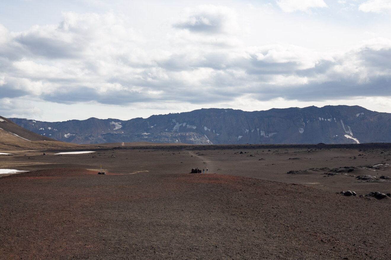
The NVZ begins immediately north (some say south) of the infamous Holuhraun eruption of 2014. There are 5 volcanic centres in the NVZ, of which Askja is the most southerly – and the largest. Askja would be a major attraction in any other region: it has an unearthly beauty, a volcanic oasis in an uninhabited lava-desert landscape with a large caldera and two scenic lakes. Quite a few tourists still manage to get there during the summer, but only after several hours of almost off-road driving. Most come on organised trips. You can get there yourself, but will need to rent a superjeep (four-wheel drive with enough clearance to get over the rubble that pretends to be a road). Be aware that you will need to ford the unbridged rivers that cross the road, preferably when the rivers are not in spate. Many pictures of Askja show the same view of the two lakes, from the same vantage point. It is close to the point where the road gives up.
Askja has had several eruptions in the past 200 years, making it a relatively active volcano with mainly basaltic lava eruptions. This post will focus on the large -and unusual- eruption of 1875. More recently there were small eruptions in the 1920’s and in 1961. In some ways the 1875-1929 activity may represent a single episode.
Since the Krafla eruption Askja has been deflating. There is no direct connection between Askja and Krafla, although they lie along the same rift. Inflation at Askja resumed around 2010. At this time the lake became ice free, evidence of increased hydrothermal activity. There were earthquake swarms. Everything calmed down again when Bardarbunga reactivated. But since a year or so there again has been earthquake activity at Askja. This coincided with Grimsvotn entering an unexpected quiet period. Deep below the brittle crust, the volcanoes here are connected. They live off the same magma supply, drawn up through their individual conduits and stored in separate chambers. They are like different banks, dispersing the same government-issued money but with their own vaults and with different terms and conditions. If Askja is a bank, its caldera may perhaps be viewed as a ‘hole-in-the-wall’ created to dispense magma.
Inside
Inside Askja caldera
The volcano rises 800 meter above the surrounding area. Most of it is taken up by a large caldera, measuring 8 km across: in fact the word ‘Askja’ means caldera (or ‘box’). There are two more craters here. The larger one measures 3 by 4 km, has a large lake, and is young: it first formed in an explosion in 1875. Just a few meters north of this crater lies Viti crater, formed in a smaller explosion in the same event. It too contains a lake, and it is near the end point of the road. Brave souls can try to swim in it. But be aware: these lakes can kill. That is a story for later.
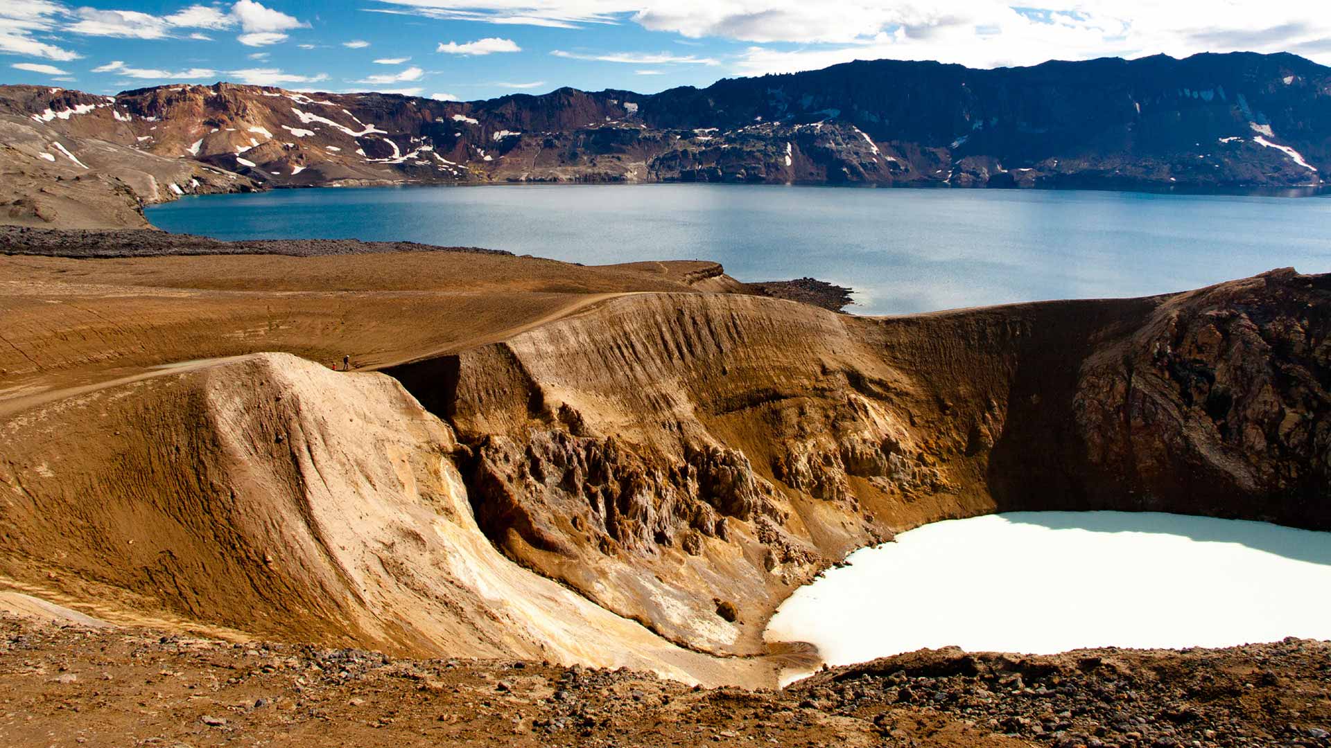
 The large lake is called Öskjuvatn. It is deeper than the main caldera. The lake is 3.5 km across; the surface is 50 meters below the caldera floor and the lake is 220 meters deep. The small Askja Víti crater is a scenic, deep hole filled with a small lake. Its lake is suitable (kind off) for swimming because it is geothermally heated. Öskjuvatn tends to be frozen and should be more attractive to polar bears than to tourists for their swimming lessons. But its water is possibly cleaner. A swim in Víti crater is certainly memorable – the stench of sulphur will cling to you for days. Stay away from the boiling vent and from falling rocks, and be aware that the slippery path is easier down than back up. In rain it may be next to impossible to get up. If a trapdoor spider would run a bank, this is what its branches would look like.
The bank of Askja
The terms and conditions of the bank of Askja are hard to read. This volcano-bank offers different products at different times and at different branches. It has eruptions at the central branch (the cauldron), in the suburbs (the ring fault and flanks), and out of town (distant fissures). The main product is basalt, but the 1875 eruption produced rhyolite – a bit like the Bank of America suddenly issuing Russian rubles from its cash machines.
Askja is a shield volcano, as might be expected from the fact that it normally erupts basalt. The caldera is enormous and it takes up much of the area of the shield. It is also remarkably deep. The main way a basaltic volcano may form a caldera is by emptying the magma chamber underneath through a distant dike. This happened at Bardarbunga which collapsed at precisely the rate at which Holuhraun erupted, leaving little doubt where the magma went. The same happened at Kilauea during the Leilani eruption. It is therefore natural to expect the same happened at Askja. The caldera is 8 kilometers wide and 300 meters deep, which gives a volume of 15 km3. The sides may have been much higher before being eroded by the ice, making the caldera more than 1 km deep. Such a large volume requires large lava fields (‘hrauns’).
Some have suggested that the caldera is a fraud. It is perhaps 200,000 years old, and for 80% or more of its life has been covered by ice age glaciers. Almost all of its eruptions were subglacial: Askja is an ice-age volcano. Effusive eruptions underneath a thick glacier form hyaloclastites and indeed much of the area around Askja’s caldera is covered in these. Lava underneath thick ice cannot flow out, but forms steep ridges above the erupting fissure. The argument is that the ridges around the caldera are hyaloclastite ridges on intersecting faults, giving the impression that the enclosed area is a caldera.
Askja is now commonly viewed as a combination of both: there was also some subsidence of the central region, but the surrounding ridges are mainly hyaloclastites, perhaps on a ring fault. The bank of Askja has boosted its appearance with a big building funded with some drastic quantitative easing.
The ridges around the caldera reach around 1200 meters in elevation, and the floor of the main caldera is at 1050 meters. It used to be deeper: there is at least 50 meters and perhaps as much as 500 meters of post-ice-age lava and volcanic debris in the caldera.

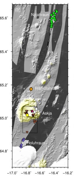
From Carey et al. 2010
The black dots show the large caldera. The lake forms an extension to the southeast, formed in the recent 1875 eruption. The centre of the new crater is on the edge of the old caldera: it used the same fault that created the caldera ridge. Shallow earthquakes (typically 2-4 km depth) now occur mainly around the southeastern edge of Öskjuvatn. This area also has hydrothermal activity. There is also at times some earthquake activity at much greater depth, up to 30 km.
Deposits
Askja is mainly, but not exclusively, a basaltic volcano with effusive eruptions both at the caldera and further afield. The largest lava fields are to the northeast, as far as 30 km for the centre of Askja. Together they contain perhaps 10 km3. There are numerous small lava flows are all around the flanks and inside the caldera. Seven such flows erupted between 1910 and 1929, fed from rifts and fissures. To the south the lava flows just reach the area of the 2014 Holuhraun lava, up to 15 km away. Askja’s rifts are lopsided, extending much further to the north than to the south. That is of course a consequence of the lie of the land: the big bulge of Vatnajokull stops the rifts going south. As they would have to flow uphill, it is a no-go area for Askja. To the north, the rifts can continue a long way, running along the side of Krafla’s rifts .
But there is more to Askja. Since the ice age there have been at least three explosive eruptions producing rhyolite. A layer of tephra up to 2 meters deep is dated to 10,000 years ago. Distant 2000-year old tephra (‘distant’ meaning that it was found in Sweden) seems to come from Askja, although it has not (yet) been found at Askja itself. The third rhyolite explosion was in 1875: it left white tephra up to 5 meters thick around the crater, and even 15 km downwind the layer was still 50 cm deep. The rhyolitic explosions produced perhaps 1 km3 (DRE) (or a bit less) in total. They were a pyrotechnic sideshow to the far more numerous basaltic eruptions .
Digging below the surface shows that Askja is more active than it may seem. This is one of the big banks of Iceland. 175 separate eruptions have been identified for the past 7000 years. This is about one eruption per 25 years. (In reality the eruptions occur in clusters, and the clusters are further apart.) In Iceland, only Grimsvotn erupts more often than that, whilst the rate is similar to that of Katla and Bardarbunga. Since the ice age, Askja has produced at least 40 km3 of lava. Not bad for a bank – Askja is a decent volcanic investment. More than half of the caldera floor is covered by lava flows younger than 1510.
The 1875 explosions
The 1875 explosion is a warning not to take this volcano for granted. In fact, the crater lake already indicates there is more to Askja than a friendly fire. Any crater lake should be viewed with suspicion. It means that something made a big hole, recent enough that it has not yet been filled with sediment. The water makes a volcano even more dangerous than it already was. Iceland has two such large lakes: Öskjuvatn and Grimsvotn. You have been warned.
Öskjuvatn formed in the third largest rhyolitic explosion since Iceland’s settlement. This is the oldest eruption at Askja where we are certain of both the date and the time. The eruption column was seen throughout Iceland.
The explosive eruption on 28/29 March lasted 17 hours. It started with phreatic precursor activity (i.e. steam clouds were seen: ‘phreatic’ means water). At 9pm a rising column was seen for an hour (until night fell) and tephra began to fall as far as 50 km away. This is considered a subplinian explosion. A larger, phreatoplinian explosion followed at 5:30am in the early morning, lasting about 1 hour, with a column up to 30 km high. It deposited a 2 meter thick ash layer in the caldera, and send tephra as far as Scandinavia. The ash was wet and sticky. The explosion was followed by pyroclastic flows in the region. After a 30 minute pause a new vent opened and another plinian explosion followed with again a 30-km cloud, this time dry rather than wet. Even 150 km downwind the tephra was still 2 cm deep. Local tephra shows that the explosion was accompanied by fountaining from the rifts or vents.
The eruption was entirely within the area of the modern lake. The lake did not exist at the time but we know that a small pond had formed. When people came to see some time after the explosions, there were three rifts visible which apparently had been the sites of the explosions. They are indicated by the white bars in the image above, and the labels indicate the alphabetic order of the explosions.
The explosions had formed a triangular depression, but it was much smaller than the current crater. The deep crater formed by stepwise collapse lasting almost 50 years, either by magma drainage or by rifting. This ended only with the flank eruptions of the 1920’s.
The 1874-1876 rift

Source: Bryndis Brandsdottir, 1992, 42, Hartley & Thordarsson, 2013
This was a very busy time for the area. The first rumblings were in January 1873, with a large explosion at Grimsvotn. This is not particularly unusual as Grimsvotn erupts often but this eruption was a bit larger than most. Some tephra of this explosion reached Askja, and formed a layer just below the ejecta from 1875.
The first signs of renewed activity at Askja itself were early in 1874 when steam clouds were seen above the volcano. We don’t know what actually happened: no one lived close, and the nearest farmers were tens of kilometer away. Earthquakes were felt in north Iceland in the autumn of 1874, and these became stronger and numerous in late December of that year. (There had been two M6.5 earthquakes of the north coast of Iceland in 1872, but this is too far from Askja to have had any effect, and they also were on a different fault.) New fissures were found in the ground north of Askja. In hindsight, a dike had been forming from Askja running towards the north, and this had caused the earthquakes and the ground deformation. But this was not known at the time.
On Jan 2, 1875, the earthquake activity became so strong that damage occurred to some farm houses. The location of the earthquakes is not entirely clear, but the damage was most severe around the Sveinagjá and Veggjastyki grabens, 50 kilometers north of Askja and the reports indicate that the activity was centred near here.
On Jan 2-3, the earthquakes culminated with an eruption at Askja. There are no eye witness reports other than the eruption cloud, and the size of this event is not well recorded but it may have been a significant explosion which produced a notable crater. It appears that at the same time there was an eruption at Fjárhólahraun a few kilometers north of Askja, as two separate eruption columns were seen. The lava field of Fjárhólahraun has been attributed to this eruption, but it appears that this is much older, possibly from the 14th century. Tephra found at Fjárhólahraun does coincide with the 1875 eruption, and there may have been fountaining activity here but without large lava flows. After these eruptions, the earthquakes diminished but did not fully cease.
The first visit to Askja (remember this was mid-winter, with deep snow, and the area was difficult to reach) was on February 16. They found new craters in the area which is now occupied by Öskjuvatn, just outside the caldera, with intense hydrothermal activity. Remember that this was before the large explosions in March, and the large new crater had not yet formed.
On February 18, 1875, activity suddenly moved far north, to the area where the earthquake activity of December and January may have been focussed. A rift eruption now occurred in the Sveinagjá graben with actual lava. A second site in this graben erupted on March 10, a third one on March 18 and a fourth one on March 25. There were eruption sites along the entire graben, although each seems to have been short-lived. A report from March 25 describes 40 active craters. This sounds more like a continuous fissure which did not develop a single dominant cone. The eruptions here produced the Nyjahraun lava field.
The next event was the major eruption at Askja of March 28/29 which has already been discussed and which affected much of eastern Iceland.
After this event, the main activity continued to be at Sveinagjá. Eruptions here were reported on April 4, 10, 24, July 2, August 15 and October 17. Weaker activity may have continued into 1876 but this was winter when it was difficult to visit. Askja itself also had some activity, with an eruption cloud on May 19, and unconfirmed reports of further activity and in the autumn and winter. In early 1876, the action ceased.
The magma vault
It is interesting that the main activity was not at Askja, but 50 km north in an area with rifts but no central volcano. It was a fairly normal fissure eruption, with lava erupting from separate locations along an extended rift. During this time Askja had hydrothermal activity and major explosions, but less evidence for lava. The eruptions seem related but they were quite far apart. Did the activity come from Askja? Or was Askja just a side show?
The composition of the lava and tephra show a relation between the two events. However, they are not identical. Whilst the tephra at Fjárhólahraun is identical in composition to that at Askja and clearly comes from the same source, Nyjahraun’s composition is a little different. It appears that the new magma mixed with an existing magma reservoir at Askja, but at Sveinagjá only the new magma erupted, not the mix.
The earthquake activity provides a second clue to a connection. The December and January earthquakes (which may have reached M5.5) were focussed on Sveinagjá. But it diminished after the January eruption at Askja. The earthquakes indicate a dike was growing, but it stopped growing after the pressure had been relieved at Askja. From this point the magma underneath Sveinagjá was trying to find a weakness to the surface. This took 6 weeks. After this the activity continued intermittently for a while (9 months) but eventually petered out.
We can speculate on what had happened underground. New magma had begun to collect underneath Askja, initially at a depth below the brittle crust. From there, in December a dike formed towards Sveinagjá. The earthquakes traced where it entered the brittle crust, near Sveinagjá. There was no reported activity in between Askja and Sveinagjá.
While the dike was forming, the magma also began to interact with an existing shallower magma chamber underneath Askja. The interaction rejuvenated this stale magma, by heating and mixing. This rejuvenation caused the rhyolite explosion of March, and also pushed some of the magma through an existing fault towards Fjárhólahraun.
The explosion removed the pressure below Askja, and the dike now no longer received an inflow of magma. The magma at Sveinagjá was still pushing up, and this caused several eruptions along the entire length of the graben. But without new magma they lost their oomph, and finally ceased after 9 months. This model is speculative but seems to fit the events.
Traditionally there have been two ideas for how rifting eruptions occurred. In the first idea, magma was assumed to collect underneath a central volcano, and a dike extended sideways from this chamber under a shallow or steeper upward angle. Where the dike reaches close to the surface, extension occurred and magma began to rise to the surface probing for the weak spots. The second idea began with the rifting, allowing deep magma to rise vertically into the vacated space. Here each part of the rift in a way has its own magma supply, albeit all are connected at depth.

Illustration of the two main models. A third model is like the one in part a), but with a second, deeper dike flowing from the deep magma reservoir. Hartley & Thordarsson 2013
The second version has not received much attention recently. The well studied rifting eruptions in Holuhraun and Kilauea left little doubt about where the magma came from, and this fitted the first idea. The Krafla eruption (close to the 1875 activity) also operated in this way. However, the first idea may not be perfect. If the main magma chamber underneath the central volcano is fairly shallow, then a dike may form below it, bypassing this chamber. It seems plausible that Laki formed in that way. For Askja also, a deep dike well below the main magma chamber may have intercepted some – or most – of the new magma and diverted it 50 km away.
The reason for the explosive activity is that Askja had been inactive for some time, perhaps centuries. The magma chamber had gone stale but not solid. These are the most dangerous volcanoes.
The final question is why the explosions were both wet and dry. Some of the activity was in standing water, and some was on dry land. It appears that water had ponded in the depression (caused by the rifting?) but not everywhere.
Holuhraun
Before 2014, Holuhraun was seen as part of the Askja rift system. This is relevant here because there are two lava fields in this area dating from around 1875. These have at times been considered as part of the Askja eruption. Of course, nowadays we know that this area is under different ownership, and is within reach of Bardarbunga’s rifts.
The two lava fields are conveniently called Holuhraun-1 and Holuhraun-2. They erupted in slightly different locations: Holuhraun-1 was 15 km south and Holuhraun-2 erupted 23 km south of Askja (adjacent to the glacier). It now appears that these flows formed before the Askja 1875 eruption. Holuhraun-1 is almost a century older, and likely formed in the winter of 1797. Holuhraun-2 is much closer in time to the Askja eruption but still a bit too early: it formed around 1863. Holuhraun-2 coincided with the eruption in Veidivotn which formed Tröllahraun.
The lava of the three Holuhraun eruptions (including 2014) is identical. We can safely blame Bardarbunga. The closeness in time between 1863 and 1875 may suggest that this was a time of general rifting in the NVZ. It started from Vatnajokull, and reached as far as Sveinagjá, a length of 100 km. Askja may not have been the driving factor: it just happened to be on the rifting path and provided a convenient and existing conduit.
Öskjuvatn

Askja’s beautiful lake holds deadly secrets. Volcanologists have disappeared without trace while investigating it. That is notable in a nation where volcanic eruptions very rarely cause casualties: in one event, Askja killed as many people (2) as all other Iceland’s volcanoes have done together since.
The killings happened in 1907. Two Germans went on to the lake in boat to investigate the caldera, on July 10, 1907. They were never seen again, dead or alive.
The Germans were Max Rudolff, a painter, and Walter von Knebel, a geologist. Knebel was 27 years old at the time, and engaged. The expedition was for his research – Rudolff was there to provide the illustrations. When they did not return, Knebel’s fiancee organised an expedition to find him. The chase was not sucessfull but at least it gave her a new life as she subsequently married the person who accompanied her on the journey.

Memorial to the disappeared
Her name was Viktorine Helene Natalie von Grumbkow; she used the name Ina. Her partner in the attempt to find her fiancee was another volcanologist, Hans Reck. Ina had to proof she could do the trip (being a woman), and did so by traveling around the Reykjanes peninsula where she visited Krysuvik and Keilir – which she climbed. Having managed that journey, the two set off on a trip that went via Hekla, Laki , Myvatn and Herdubreid – the volcanology interest of Hans Reck showed – before reaching Askja.
Ina wrote a book about the failed search. Arriving at Askja, she writes
“The Askja crater has in all directions almost the same diameter of around 9 km. The diameter of the almost round lake sunk in the southeast corner of the basin and named in memory of my fiancé Knebel-lake is 4-5 km. Despite the distance, we often saw the dust from the avalanches on the south wall opposite our tents and the water splashing up on the edge of the bank when particularly large blocks had fallen into it. As already mentioned, the lake is enclosed by steep walls in the south and east. Especially on the south wall they are completely inaccessible. The over 300 m high wall here consists of a fusion of rugged almost 100 m high palagonite cliffs, the tips of which stand out sharply against the sky, with heaps of rubble that stretch from the foot of these cliffs to the lake level – the paths of the never-stopping dangerous rockfall. There is not a foot of flat land at lake level”
“On the west side, the lake is bordered by an approximately 60 m high bank. In its entire length it shows the colourful stratification of basaltic lava and coloured slag with the generally golden pumice covering in the Askja basin. The north side of the lake has the 80 m deep Rudloff crater (named after the young painter Max Rudolff who had an accident with Dr. von Knebel), at the bottom of which green-yellow sulphurous waters boil with alternatingly strong steam. The crater is very close to the lake, so only a very narrow ridge allows it to pass between it and the lake.”
After a difficult and fruitless search, the party left again, with one final look at the place where her fiancee had disappeared:
“A wonderful distant view presented itself once more from here. Towards the south the wide Askja basin, filled with black lava flows and white patches of snow, framed by multi-shaped, colourful mountains trimmed with snow. Far, far beyond, beyond the whole width of the southern Ödahraun the Vatna Jökull in light beauty. And on the whole, the transfiguring appearance of inviolable majesty, the highest solitude and original perfection. As the early morning mist melts under the rays of the rising sun, so all the glimmers of the modern world fade before the unsophisticated grandeur of this pure nature. The same word that was coined for millennia for the lilies in the field is still valid here today, in view of all this silent splendour: that Solomon in all his glory was also not clothed as this one.”
The names that she bestowed on the lake and crater have not survived modernity, but the four meter tall pyramid they left as a memorial is still there. The lake is now called Öskjuvatn, and the small separate crater is called Viti.
The in-land tsunami
At the time, the caused of the disappearance remained unknown. A popular suggestion was that they had used a poorly build boat which had sunk in the lake. But it now appears that the two Germans may have vanished because of the frequent rockfalls that Ina described.

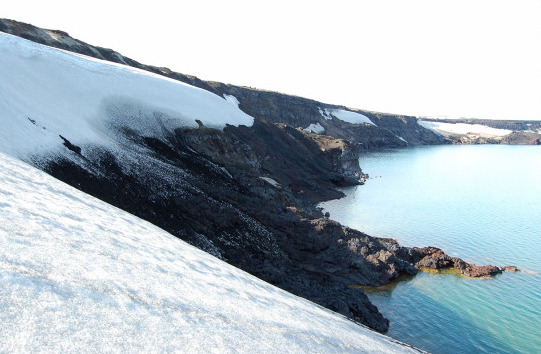
On July 21, 2014, a landslide occurred on the southeastern cliff above the lake. The cliff collapsed over a length of 800 meters, between 150 and 370 meters above the water. Half of the debris, or 0.01 km3, slid into the lake, mostly as a single block. It caused devastation. In hindsight, movement on the cliff had started 7 years earlier, and the creep had already reached 25 meters before it gave way. But no one had noticed the change and the collapse came as a complete surprise. The landslide was among the largest in Iceland of the preceding century.
The original cause was probably the long-term subsidence of the crater along the ring fault. The final collapse came after the ground had been weakened by snow melt (asn effect already described by Ina) and by heavy rain.
Luckily, the collapse happened at midnight and no tourists were present near the lake. They would have seen a frightening event, and probably not have survived. The block slid into the lake at a speed of 140 km/h, and traveled 2 kilometers along the bottom, disintegrating along the way. The block pushed up the water, and this wave started traveling out at high speed. Even lakes as small as Öskjuvatn can have tsunamis! And lake tsunamis are even more dangerous than their open water counterparts. The water bulge can’t spread out – instead the water becomes focussed towards a small area on the far side. The wave here can reach enormous heights. The run-up at Öskjuvatn along the shore reached up to 80 meters! The wave traveled at 50 m/s, and reached the opposite shore in 1 or 2 minutes. By the time people exploring the lake would have recognised this phenomenon was not put on for the tourists but deadly dangerous, there would not have been enough time for them to climb to safety.
The debris was sufficient to raise the level of the lake by 0.5 meter. But that was a minor side show compared to the lake tsunami.
Black sand from the bottom of the lake was left on shore by the tsunami, reaching heights of 60-80 meters
Ina reported numerous small rockfalls into the lake. This was at a time when the caldera was still forming through slow subsidence along the faults at the edges. The disappearance in 1907 was at the same time of the year as the 2014 collapse. This is the time when snow melt can destabilize the ground, something also noticed by Ina. The suggestion has therefore been made that the two Germans were on the lake during a collapse, and were swamped by the wave.
Final words
Askja is a highlight of Iceland, worth the effort it takes to visit, at least when the roads are passable in summer. But it is also unpredictable and dangerous. White Island has shown us the dangers of volcano tourism. The lessons also apply to this giant of Iceland’s sleeping beauties.
And activity is on the rise. Hydrothermal and earthquake activity increased in 2010, and for a while the lake even became ice free. After a calm period, earthquakes resumed last year and since a month there is rapid inflation. Magma is on the move. The inflation is centred not at the new crater of Öskjuvatn, but at the centre of the old caldera. This is a significant influx. Will there be an eruption? Will it be in the caldera, along the surrounding ring faults, to further away? Will the bank of Askja collapse? It is far too early to call wolf. But perhaps it is a good thing that the tourist season here is ending.
references
Gylfadóttir, S. S., et al. (2017), The 2014 Lake Askja rockslide-induced tsunami: Optimization of numerical tsunami model using observed data, J. Geophys. Res. Oceans, 122, 4110–4122, doi:10.1002/2016JC012496.
Hartley, M. E., and Thordarson, T. (2013), The 1874–1876 volcano-tectonic episode at Askja, North Iceland: Lateral flow revisited, Geochem. Geophys. Geosyst. 14, 2286– 2309, doi:10.1002/ggge.20151.
Carey, R.J., et al. (2010), Tephra dispersal and eruption dynamics of wet and dry phases of the 1875 eruption of Askja Volcano, Iceland. Bull. Volcanol. 72, 259–278
Hartely, M.E., et al. (2016), Postglacial eruptive history of the Askja region, North Iceland.Bulletin of Volcanology 78, Article 28
Brandsdottir, B., (1992), Historical accounts of earthquakes associated with eruptive activity in the Askja volcanic system. Jokull, 42, 1
Ina von Grumbkow, 1909. Ísafold: Reisebilder aus Island. http://www.isafold.de/klassiker/default.htm
Albert, September 2014


Lates video update from GutnTog (dated September 14th) showing the pulsating activity in the crater and the flow field outside of it:
https://www.youtube.com/watch?v=ndSPSwtZFQo
He promised to upload drone footage from the crater that he took today once its processed.
https://www.youtube.com/watch?v=wAGkwyzvlOk is his dusk view
Currently, Fagradalsfjall has a periodicity of 12 min.
The volcano is about 2.5 min/12 min = 21% active.
I started counting when the Langihryggur live view was about half yellow/white.
Greetings =)
Inactive for 15 minutes straight now …
Now over an hour. Tremor plot doesn’t show a drop into a longer lull, but the camera scrollback doesn’t show any activity at all during that time, with episodes every ten minutes or so before then. The satellite vent in the lava field included — it had been active again, but not in the past hour.
Looking at the drumplot, it might be starting up again now.
There also looks to have been three other events, but it could just be too dark and too weak to see anything.
It’s visible on the Keilir cam.
https://www.livefromiceland.is/webcams/keilir/
that cam just keeps loading for me…. is there a secret to see it live?
The secret is just to keep trying Mots. It’s always been hit and miss with that camera. I had a problem loading at one point, refreshing didn’t work, so I looked around then came back and it loaded ok.
People suggested the rate of the eruption is lower since it resumed. I don’t think that is true. The height of the surface has increased 10+ meters in 5 days. A very rough estimate would be about 5 million m^3 assuming lava lake is increasing same amount in all directions. It is a perched lava lake, because otherwise it would have reached Natthagi long ago. North Geldingadalir must be ~25 meters higher than the southern exit by now. That is not a stable situation!
Blue shows the extent of the lava lake when the 3-d model was done on the 9th. Red is the extension to the north since then visible on the one Meradalir camera. The black circle is where a little lava fountain was visible on the Langihryggur camera, which shows the lava lake has extended at least that far. https://imgur.com/a/u3gdBRX
Maybe if the output was restricted to a single vent it could have channeled better, but it just spread out instead among multiple. It is still doing that now, though it is filling up towards the north ebd more than towards Natthagi. That is all very temporary though, it wont be able to avoid it forever.
This sort of activity is slow to advance but can go much further. When Pu’u O’o was fountaining it flowed multiple km in a day but never reached the ocean. The flank vents took months to flow so far yet reached the ocean easily, or flowed as far as 25 km in 2014. If this change is the switch from stage 2 to stage 3 in a few weeks we are looking at an ocean entry.
RUV Langihryggur camera died at 21:42, Island time.
So if you are wondering why there’s no activity visible from the volcano – that’s why!
LaPalma drum plot link.
https://www.ign.es/web/ign/portal/vlc-senales-sismicas/
Looks like its dying down …
But not strange .. magma supply is tiny to this Island
I really think that Askja is going to erupt, a ridiculous amount of Magma is going into this system around 0.12 km3 a year so far! I’ve had enough tourist eruptions! I want 3 km high lava fountains and an incredible volcanic winter so powerfult that our ancestors will shiver with fear when the name of the volcano is mentioned! I want every country and people to realize the power and devastation that has been held back and to realize the futility of unimportant conflicts and events. I want to see and experience the humbling of humanity.
That’s not going to happen from Askja. It’ll be an Icelandic VEI4 at best.
Oraefajokull might be a bit more damaging locally and in europe.
I don’t think we’ll see the eruption of my dreams at Askja but the volcano is capable of doing VEI 5+ level eruption so let’s not hold our breaths
1875 was a VEI 4, it was very powerful but bulk volume DRE was well under 1 km3. It was considered bigger once because it was rhyolitic and assumed to have created Oskjuvatn caldera but now we know that wasnt the case. The older caldera was probably created in a rift during the early Holocene, there was rhyolite erupted then too probably more than 1875, but Askja is pretty much an effusive basaltic volcano.
Really in the present day only Oraefajokull is potentially capable of what you are talking about, and maybe very unlikely Snaefellsjokull. Hekla was once, but not anymore.
I am pretty sure that the 1875 eruption was a VEI 5
https://pure.port.ac.uk/ws/portalfiles/portal/13243958/Detection_of_the_Askja.pdf
https://www.researchgate.net/publication/225386142_Tephra_dispersal_and_eruption_dynamics_of_wet_and_dry_phases_of_the_1875_eruption_of_Askja_Volcano_Iceland
https://d-nb.info/1143036441/34
We have had discussions in the past about which volcano might be the next VEI-7. We are looking for something large, largely inactive for some centuries, and apart from that we don’t really know. Want to make a guess? Yellowstone is excluded from the competition because of bad press, and for being as unlikely to erupt as Kansas. If you want fear, hurricanes might be better for you. The recent one was so bad they named a US state after it. Ida-ho.
I think Corbetti is a good bet, Africa hasn’t had any large explosive eruptions in years, Los Humeros is also on my list
Really? Be careful what you wish for lest it come to pass. I don’t think it would be that much fun to pay for my volcano fix with the humbling of humanity in a volcanic winter lasting who knows how long. I’d prefer to see my grandson grow up to become a responsible caring adult and not see him starve and freeze to feed your volcano addiction. Rather than wish the human race to be laid low, get out there and raise them up.
The future for our children is already bleak no matter how you look at it. The entire world is heading towards ecological collapse with or without anthropogenic climate change and no matter how much you or I do, we won’t be able to avail our current path. The modern human is far too pathetic to stop the destruction of his/her society, I refuse to put an iota of faith into our current society. It’s always possible that my cynical view is completely wrong and some charismatic genius will guide the world into sustainability but I have my doubts. Society ending because humans are poor managers of their own technology is so lame 🙁 A volcanic eruption worth 10,000 plus nukes is fun 🙂
I am far more optimistic. We have major problems but they are solvable problems. The answer isn’t in left-wing or right-wing politics, but in knowing what we are trying to achieve. We do not need to go back to 19th century CO2 levels or population, but do need to avoid large increases over current levels. And we know how to do it.
Unfortunately, people think of ecological issues as political issues and political tools. Solution exist but people are too rooted tribalism and a misplaced sense of irresponsibility to do anything significant
https://youtu.be/8yUurzaCkp0 has GutnTog talking about the dense smoke that the active cone is emitting on Sept 14th
https://m.youtube.com/watch?fbclid=IwAR3hmaG4_kBl7-O_NXcwObQpr1qc0y5FGpaRwPuBnDLHrPvsGl3dakuRiHQ&v=8uuf1LyMM3k&feature=youtu.be
Iceland eruption continues
And the lava is getting very fluid indeed like Hawaii.. fagradalshraun is low low viscosity
I like the vid much.
Sometimes makes me think of ice on larger lakes. Ice dams, ice floes. The proces which makes them is not quite the same. 😊 Both water and lava are sculpturing on the transition liquid solid nice things!
Reminds me of skating on the lakes in Sweden….
From this view

it looks to me that lava might follow a new path down into Meradalir rather than the Natthagi end.
Around 41 mins in the above vid
Still pitch dark at the site at nearly 9 am local time. Before the autumnal equinox.
What the hell is going on with the weather there?!
Stills camera shows light before 6am GMT. If you’re looking at the Langihryggur RUV webcam or other feeds using it, it’s been down for several hours.
Try these: https://www.almannavarnir.is/eldgos/myndavelar/
There is a difference between the cam picture you think you see, the cam picture you actually observe, the picture the cam sees and the actual reality. For example, if you see a monkey on your screen it might be an illusion, or the cam picture indeed shows a monkey, or there is something that actually looks like a monkey at Fagradalsfjall (e.g. a rock formation, a visitor, a picture of a monkey hold in front of the cam,…), or there might actually be a monkey in front of the cam. These remarks apply similarly to an allegedly black image.
I think the RUV crater view cam is blacked out again. It’s light on https://youtu.be/7-RhgB1INII
The time zone in Iceland is a bit out. When you consider that the island is quite a bit further west than the UK, yet is in the same time zone in the winter, you would probably expect it to be around two hours behind. Also, the RUV camera appears to have stopped working at 21.42 last night, according to an earlier comment. It looks like the sun is now rising on other cameras (sunrise 6.52), but is still very low, so there are lots of shadows.
As I said earlier:
RUV Langihryggur camera died at 21:42, Island time (14 September).
Looking at the GPS page at IMO, it now looks like there has been steady inflation at Fagradalsfjall, since the pause. It wasn’t clear before, but it now looks much clearer.
http://brunnur.vedur.is/gps/reykjanes.html
I don’t see that. Are you referring to this:
?
It’s difficult to tell anything from that one, as the difference is quite small. If you look at the one to the left of that one (the longer term chart), it looks like it is starting to go back up, although today’s point has been added since I Iooked, which is lower. Now it is erupting again though, I would think it is likely to stabilise. The longer term chart shows steady deflation for quite some time, until the last few days. At first, I wasn’t sure if it was going back up or staying level, as the points are a bit up and down, so you need to see the overall trend.
It’s also still within the margins of error, which is why the tredn is important.
Indeed it looks a bit as if the deflation is halted latetely. Maybe we have to be patient and see if this becomes a trend.
Regarding the eruptions at Holuhraun being in the 1860s, that does actually have some bigger implications. If you look on a map Holuhraun and Trollahraun are both about the same distance from Bardarbunga. Trollahraun has a volume of about 0.5 km3, though it is two eruptions close in time, Holuhraun 2 I would guess is maybe 0.2 km3, maybe a bit more. There also were probably more vents further south under the ice as there were in 2014.
Overall because the area rifted was about twice as big as 2014 the event was probably just as big, that is to say instead of being a minor eruption that was just outside the icecap it was actually a major eruption that got distributed instead of focussed to one area like in 2014.
I dont know if this is true but I think there was a smaller intrusion southwest back in 2014, but it died. Maybe rifting events here are much less directed than we like to believe and can go both ways. Seems maybe instead of being a forced intrusion the whole rift is the volcano and the central volcano we designate is just where there is a magma chamber relatively close to the surface so can collapse. So kind of half way between the scenarios 1 and 2 in the article, lateral magma flow but central volcanoes are not the dominant player.
M 3.2 – CANARY ISLANDS, SPAIN REGION – 2021-09-15 09:25:20 UTC

https://www.mirror.co.uk/news/world-news/popular-spanish-holiday-destination-risks-24980862
It seems to have calmed a bit in number of quakes but they are also shallower within 5-8 km depth and some around 2km, inflation is around 6cm now. Its still early but an eruption seems a bit less improbable in the near future.
But is the swarm still going then?
yes, the problem is IGN site is kinda down so earthquakes are filled in a bit later in the list.
http://www.ign.es/web/resources/volcanologia/tproximos/canarias.html
If it erupts You will get very low sillicate Basanite lava
As low as 40% sillica, very alkaline and sodium rich
Partial melting is very small in Canary Islands ( weak hotspot )
But the magma If it emerges will be relativly cold and Viscous.. as it often is with alkaline magmas
Involcan have reported there is uplift of 6cm on La Palma.
Update courtesy of Involcan.
Translated.
”Informative update on Earthquake-volcanic activity in the Volcano Cumbre Vieja (La Palma, Canary Islands)
The Canary Geodesic Network, operated by the Volcanological Institute of the Canary Islands (INVOLCAN), has registered significant deformation of the volcanic land in recent days.
The figure shows horizontal (red arrows) and vertical (black arrows) displacement in some of the GNSS stations that are part of the net. This deformation pattern can be interpreted as the effect of pressurizing a small magmatic reservoir, located inside the Old Summit in the same area where most of the earthquakes of the recent swarm are being located.
This observation confirms that the source of this swarm, which began last Saturday September 11, 2021, has a magmatic origin and is related to the intrusion of a small volume of magma inside the Volcano of Old Summit.
INVOLCAN will continue to be updated on the evolution of this new seismic swarm at the Volcano Summit. Remembering that it can’t be ruled out to intensify the seismicity felt in the coming days, depending on the evolution of activity.
The current situation of the volcanic traffic light is in AMARILLO for the municipalities of El Paso, Los Llanos de Aridane, Mazo and Fuencaliente de la Palma; therefore, keep an eye on the information provided by the relevant Civil Protection authorities.”
I don’t really understand if how this intrusion could be small when it has already caused 6 cm of deformation in less then 2 weeks
I Agree, the only thing is that sometimes in la palma eruptions start with a bit more ash and explosions as magma can meet underground water but that happens mostly in the vents at the top not where earthquakes are now.
The magma supply to each Canary Island .. is absolutley tiny .. only makes alkaline sillica undersaturated primary melts
Update on the inflation.
https://tenerifeweekly.com/2021/09/15/the-involcan-registers-a-significant-deformation-of-the-terrain-of-volcanic-origin-in-la-palma/?fbclid=IwAR10JoMqXRJKr7GaP_ins1qYog4fW3GPKxPObKm-7VI-iByb4UCm_KyMG-k
https://youtu.be/kQ5evOZ4VAc
Recently posted on YouTube. With revised positions for the bubbling ‘vents’, showing that the lower areas between vent 2 and 5 are being filled, but not the flat area west of cone 2 yet. The lava lake doesn’t appear to be spreading towards the south.
Oops spoke too soon, this fb live posted 37 minutes ago, so the flow started about an hour ago. Path A is apparently closed due to risk of gas and overflowing lava.
https://www.facebook.com/groups/icelandgeology/permalink/1012113612959192/
Lava flowing to Natthagi again. https://www.youtube.com/watch?v=BA-9QzIcr3c&ab_channel=R%C3%9AV
Rewind to 1109 to see the start of it.
(And at 1110 the camera runs a “Speed Dry”, which seems to involve shaking itself like a dog to get rid of water).
The upper valley seems to be filled up completely now. There are multiple new locations where it is flowing down. I wonder how long that new embankement up there is holding…
Looks good at http://brunnur.vedur.is/myndir/webcam/2021/09/15/webcam_storholl_leidigardur_S.html

It took only 10 minutes from 1053 to completely flood that area though, which explains the closure.
Also http://brunnur.vedur.is/myndir/webcam/2021/09/15/webcam_borgarfjall_natthagakrikiNA.html
And http://brunnur.vedur.is/myndir/webcam/2021/09/15/webcam_borgarfjall_natthagiNNA.html
has still to update
Hello!
A massive lavastream is going south. Watch RUV/Langihryggur cam…
https://www.youtube.com/watch?v=BA-9QzIcr3c&ab_channel=R%C3%9AV
Cheers
Christian
And it is tourist friendly!
And one bloody woman obscuring the view of the lava racing down the hill to the field at the bottom. The mountain top there must be big enough that they don’t have to get in the way of the camera. She wasn’t happy when a man walked around and blocked her view in front. I laughed though. 😀
The are closing down the area.
https://www.visir.is/g/20212156296d/ryma-svaedid-eftir-ad-hraun-straumur-for-o-vaent-ad-renna-a-miklum-hrada-i-natt-haga
Lava lake is overflowing and exiting Geldingadalir towards the south (11.10)
(<- this is what the last 15 postings are about)
Btw.: Now we know exactly where all this lava went to.
Sorry about that. Despite refresh those postings didn’t show. Now I understand why there’s so many repeat postings here 😉
It is an exciting development anyway. There is also quite some new lava north of the cone, so we can expect some new lava flows down to Meradalir.
Back online: mbl.is Nátthagi camera.
https://www.mbl.is/promos/elgosid-i-beinni/
http://brunnur.vedur.is/myndir/webcam/2021/09/15/webcam_borgarfjall_natthagiNNA.html
View of overspill from Borgarfell shows the berms are keeping the lava in it’s bed flowing towards Nátthagi.
https://www.mbl.is/frettir/innlent/2021/09/15/allsherjarryming_vid_gosstodvarnar/
Helicopter video embedded in this mbl.is post. What do we make of this? Is it the lava lake bubbling out over a widish oval area? Hmmm…
That looked truly frightening…
Did the contents of the lake find a way out, or is this something new?
To me it looks like the perched lava lake collapsed (probably some barrier under the surface) and sent a big flow towards Nátthagi. The flow already stopped so it probably was a singular event.
And amongst all the hoo-haa, a human again climbs the crater to the top, can be seen on the rim at 10.10.10… *facepalm*
Well, I do believe that one needs to be a human to apply for the Darwin Award….animal life isn’t that daft!
This person needs some serious help!
Sacrifice to the volcano breaks free and runs from terrible fate.
Iceland doomed to Ragnar’s fury…
photographer, it seems
Which webcam, Stars?
It seems that Fagradallsfjall is the only volcano in the universe… i read this blog since the beginning, and the comment space was never so boring… there are so many interesting volcanic situations, but the blog is flooded with Fagradal hooligans…
And perhaps an alkaline eruption on La Palma : )
I get your plaint, certainly. But it’s like what I tell people who don’t like Facebook/Twitter/Youtube, etc.:
Demand your money back! 🙂
Not surprising. There is a steady high density data stream and constant changes in condition that makes it worth following.
La Palma, as an example has had the odd flurry of posts but nobody on the ground commenting and a datastream basically giving the (occasional) earthquakes perhaps once a day.
So plenty to discuss on the former and little on the latter.
You should have seen the blog in 2018! You would think the only volcanos in the world were in Hawai’i! How odd that a volcano-centric blog talks a lot about a photogenic, active, and well-monitored eruption.
It’s a particularly odd complaint in that the blog post itself is about a DIFFERENT volcano that’s showing signs of unrest.
Then how about contributing some interests you have to the blog? A few comments, an article or two?
We’re always keen for input!
Simple enough, just write a comment on something else you find interesting and hope that others follow. Make it interesting enough and I’m sure someone will take the bait.
Well, OK. Here’s one. Savo, in the Solomon Islands. Passive onlooker of many sea, land and air battles in 1942-3 Guadalcanal campaign. Marks entrances to Ironbottom Sound, graveyard of many ships & aircraft.
Explosive volcano with recorded history back to 16th Century, now restless. Solomon Islands govt concerned enough to send a team to assess & report. Link: https://sbm.sb/2021/08/02/govt-closely-monitoring-increased-seismic-volcanic-activity-on-savo-volcano/.
Volcano Discovery suggests Savo is most dangerous volcano in Solomons owing to proximity to capital city Honiara on Guadalcanal. There may be other interesting Solomons volcanoes, e.g. Kolombangara.
Thanks to learned writers & commenters for most interesting site. // Mike
oh that does sound interesting, will go read the link – thanks
Sounds like the mental image I had of volcanoes as a kid. I must have drawn hundreds of pictures of tropical islands with a massive cone sticking out the top. Always with a black cloud above it and red lava running down the sides.
It’s indeed very close to Guadalcanal. A large enough PDC could potentially cross the water, or send a devastating tsunami that way. One to keep under close watch for sure.
The only running game in the early few seconds as geologic time goes, rating a play by play at the moment. Van Halen as opposed to Jerry Lee Lewis. Sooooo, if you can’t be with the lava you want, love the lava you’re with.
Not much lava is finding it’s way to Natthagi:
– https://www.mbl.is/promos/elgosid-i-beinni/
Well, it was a bit of a one-time pulse event… And it came out of the ground with quite some fervor, based on the helicopter footage.
I (like others it seems) would guess what happened ist that the “perched lava lake” (the lava in the “enclosure” up in the north of Geldingadalur) melted its way vertically down somewhere quite far up, and made a connection to the still-liquid lava lake that exists a few meters down below the crust everywhere in Geldingadalur. This pressurized the underground lake so much that some weak spot further down the slope gave way to the pressure, draining most of the liquid back out onto the surface, creating that big flow until the pressure lowered closer to previous levels. A consequence could be that if the lake receives substantial lava again, that underground conduit could stay open and forward the lava straight to that exit on the slope. Which would speed up delivery to lower Natthagi, bad news for the road.
But it appears any outflow from the crater right now is going due north? Very friendly, a nice move by the crater!
And Askja keeps inflating. Almost 10 cm now.
https://www.mbl.is/frettir/innlent/2021/09/15/landris_i_oskju_nalgast_tiu_sentimetra/
La Palma is up 6 cm already
People are walking on the lava in Natthagi
Someone will get a Darwin Award very soon at this rate
Canary Magmas are really strange ..
Very very very very alkaline often, signs of that the Hotspot is very weak. Basanites and even Nephelinites are common in Canary Islands.
La Palma is mostly a pile of Basanite I think.
Phonolites as evolved magmas are common too in the Canaries.
Really shows How little melting There is in the Canaries Hotspot.
Regarding the idiot -sorry, I mean person seen climbing the crater today, here is the immortalization of a person who operating at the limit of life expectancy. From the movement, I would guess a photographer. Consider this a Darwin Award nomination
Thanks to Stars1die for spotting this person.
In my guise as a photographer, having seen some of the woeful lack of sense of self-preservation amongst some photographers, it wouldn’t surprise me.
crazy, totally crazy. Peoples drones have melted being that close. The view must have been spectacular, but not worth that risk, no way
It was worse than you think. Lava glow was present a few minutes before and a few minutes after. The sulphur alone would be severely life shortening.
I cannot take all the credit, it was a topic in one of the YouTube chat streams, with a half hour timestamp window. I was skipping through, and couldn’t believe my eyes at the silhouette… I clicked away to be sure, and then had to refind him again as I hadn’t marked the time!
Gives some scale just how HUGE Ragnar vent really is.. its colossal
This is becomming a major volcanic event If it is allowed to keep going
Melt production is totaly massive in Iceland.. probaly is alot more magma to tap from the arera .. and perhaps chads hell machine have started too
The magmas are nice lunar like Thoelitic Basalts
“Holy ‘Bird of Paradise’, Batman!!”…….and not even a taboo for an offense.
La Palma seems to have quietened down in terms of earthquake activity in the last day. How likely is a “Day after tomorrow” scenario? I suspect that those who say that half the island is going to fall into the say are engaging in fear-porn.
Probaly is a failed eruption
Magma supply is insignificant in these Islands
Dude, the swarm is still going! This hotspot ain’t no iceland or Hawaii but it’s still good enough to produce a decent eruption
Alkaline magma is not only made by low degrees of melting but also by deeper melting. Etna is alkaline and is just as productive as any of the Icelandic volcanoes. Nyamuragira and Nyiragongo are even more so, both are much more productive than the tholeiitic Afar province.
Remember too Tenerife is the second tallest oceanic island, and was possibly even taller than Hawaii back in its peak height.
Virungas and Etna are an rare exception of alkaline productivity
Most alkalines are NOT productive at all .. acually
Alkalinity is a hallmark of weak oceanic hotspots like Tristan and small monogenetic fields like Auckland.
Many Subduction Basalts are also alkaline
Iceland, Hawaii and Galapagos are the strongest oceanic hotspots they produce lunar like Thoelite
If we are lucky We may get a small ultrabasic Basanite eruption at La Palma
Hopefuly the lava will be cold and and quite viscous .. because of very low temperatures
Looks as though Taal is still fluctuating in terms of SO2 emissions. It appears the big has returned to the surrounding areas. Over 15,000 tonnes recorded on the 14th September.
Groan, autocorrect slightly screwed that comment up, not sure what “the big has returned” means.
https://www.facebook.com/groups/723920061016637/permalink/7052560271485886/?sfnsn=scwspmo
Video of the lava flood at the Nátthagakriki berm.
https://www.facebook.com/groups/723920061016637/permalink/7052528791489034/?sfnsn=scwspmo
This looks like where the illegal bulldozed area was?
And now they are talking about Grímsvötn. It’s ready they say, all we need is one jokulhlaup and it can go boom.
https://www.mbl.is/frettir/innlent/2021/09/15/grimsvotn_tilbuin_ad_gjosa/
Another 3.2 quake at La Palma http://www.ign.es/web/resources/sismologia/tproximos/prox.html and that’s a lot of quakes on the map.
https://www.ign.es/web/resources/volcanologia/html/CA_noticias.html#20210914 shows the La Palma alerts(Google translate does a fairly good job of translation)
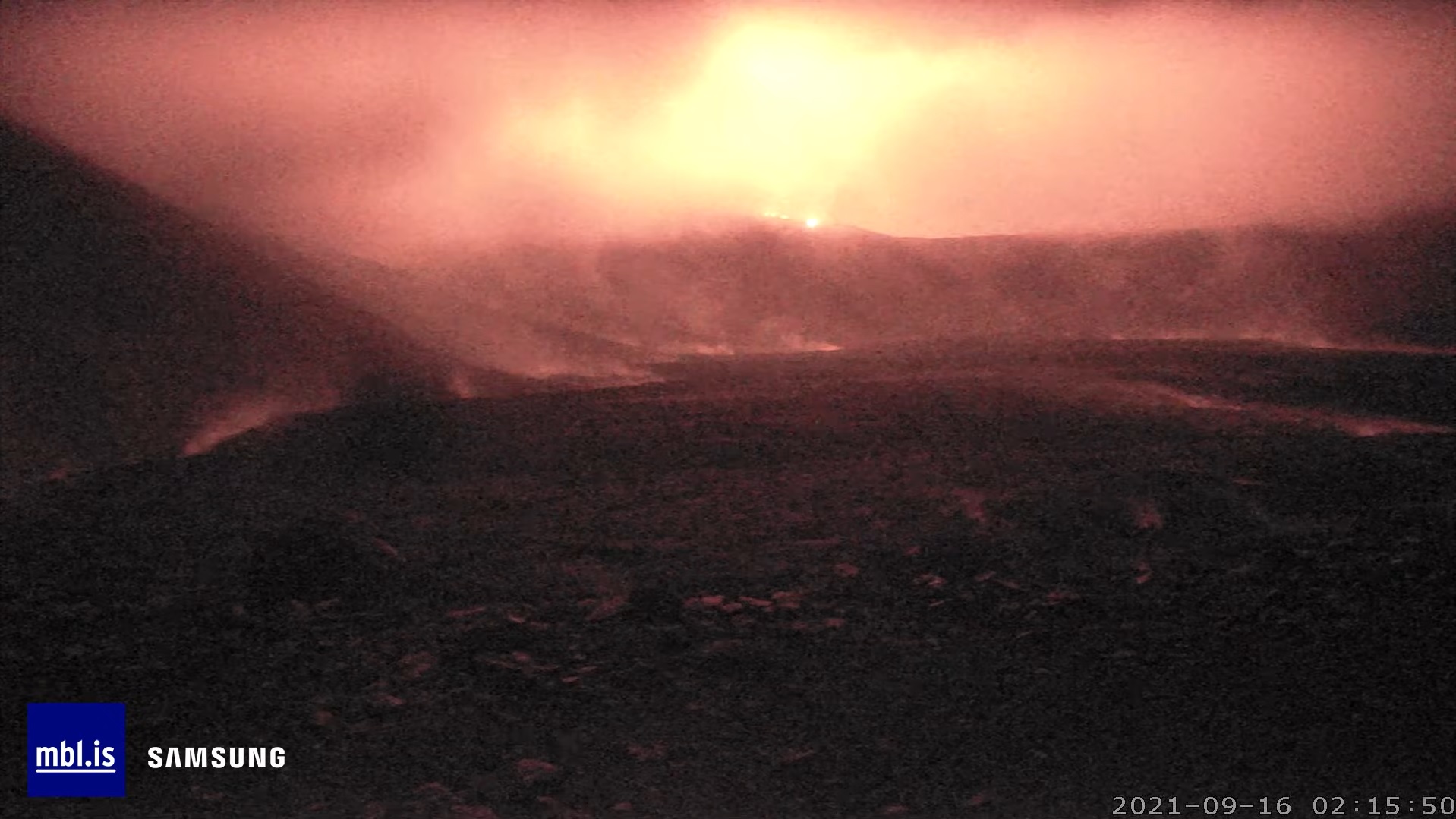
Rather intense glow showing on the MBL Nátthagi camera now, from the hills behind the valley.
There’s also sharply defined glow coming in and out of view behind clouds, on the way down into the valley. Slightly to the left of the back of the valley.
Something is going on up there…
A screenshot to go with that:
Bizarrely, the Langihryggur cam shows just empty night without so much as a dim glow in the crater mouth, at the same time.
What it going on with RUV lately? For a long time they were more reliable, if the images of poorer quality, than MBL. Now they’re next to useless it seems. And still no good view of the west/north side of the cone from anyone. Does it not occur to them that there might be demand for such a view?
The Langihryggur camera is much higher and further north than the MBL Nátthagi camera.
Now that the clouds close in again, there’s much less glow visible on the MBL camera as well.
Anything but thin clouds are really good at blocking light, most of the glow that was visible on the MBL camera was reflected, not transmitted.
Glowing lava seems to be in the upper part of one pathway down into Nátthagi but not making much progress. Observations hindered by persistent bandwidth problems of unknown cause. The Nátthagi feed is getting stuck buffering a lot; to see anything new I keep having to seek to a random spot, then hit the “live” button to jump to the present again.
RUV’s seems to be useless at night now, even in the absence of fog.
We could use to have more than just a duopoly of camera providers in the area …
The RUV Camera is switched off at night therefore it is always black. I understand it is to conserve energy – remember the nights are getting long in Iceland this time of the year, so not much charging. There might be few if any cameras left once it becomes really dark and icy. So far at least they did things mostly with solar.
https://www.youtube.com/watch?v=UlgX31WF-Jo
Here is the source of the recent big flow.
Seems it is a breakout of the lava that has been accumulated in the valley since the eruption began. But I think this, as well as the fountains the other day, do deserve to be called new vents. That old lava lake in Geldingadalir has been deeply buried under the shield structure, and also it seems the activity of this past few days is a result of lava directly intruding into this lava body, as in the first time it is at the surface is at the fountains. It is very similar to the lava lake formed in Alae crater during the Mauna Ulu eruptions, it did begin originally as a rootless lava lake but evolved into something that can really only semsibly be called a shallow magma chamber, it formed its own shield and lava also fountained when it was erupted, showing it was not directly sourced from surface lava in Mauna Ulu but did have a bit of independence.
It is maybe all a bit pedantic, but I think these breakouts should all be considered new vents properly, it sounds liek the expectation is still that new vents will only form on the original fissure line and so anything that deviates from that must be something else, that was true back in April or May but now the conditions have changed.
Is this picture not showing some overflow towards Natthagakriki during the night?
– https://maps.acme.to/gos/slideshow.php?getcam=webcam_borgarfjall_natthagakrikiNA#images-44
It seems like a lot of lava has accumulated at the top there and some of it is flowing into Natthaga, but the rest is still resting at the top. I havenät found any good pictures of that part of the lava-lake though…
As I understand it, this still camera gives an overlook over Natthagakriki from a hill close to the Volcano parking there.
It is hard to tell but it could be overflowing yes, a little bit anyway. Not really surprising.
I wonder if maybe we are now in stage 3 of shield building, constant slow effusion from flank vents. The recent flank breakout was releasing a lot of pressure but maybe never closed, now is just leaking lava at the base rate. Pu’u O’o flows always did this too, mini lava floods that then stayed open, I immediately thought of the flow from August 2011 back then as soon as I saw this recent lava flood.
No, Natthagikriki is on the lower left corner of that image. The berm is in the top left. All that glow is in south Geldingadalur at the top, and below in the old lava path as well as the new path down into Natthagi.
That looks more like the meradalir side, lavaflows close to the rim, whilst the Natthagi side has a tall section of cone.
No lava going that way, it was not very obvious because of poor visibility but the shield managed to build up on every side except the northwest side during the activity of July-August. Maybe not coincidentally this last side is exactly where the new activity has happened, the steep crater went from being a barrier to becoming the weakest link, I do expect it will continue to collapse over time especially if this is sustained effusion eroding the tephra.
I dont think we will see any lava go into Meradalir for months now, not until this new activity builds up enough of a structure to flow to the north past the old Flo vent, or the lava lake in Nar rises enough to overflow which will probably be in equilibrium to lava in Geldingadalir now, so still above scenario. Of course if this eruption lasts for years it will go pretty much everywhere anyway but that is for time to tell.
Is La Palma still shaking?
Or is it dying down?
Its still ongoing around 0800 this morning stronger quakes.
https://www.ign.es/web/ign/portal/vlc-senales-sismicas/
Now it seems to have died down a lot, just a very small intrusion probably
Its not died down this mornings graph.
https://www.ign.es/web/ign/portal/vlc-senales-sismicas/
I mean it continues but with fewer quakes and smaller in magnitude, althoigh shallower ones, are ign links working for you? i can only see the quakes map.
That can be a sign of an eruption being imminent, maybe when it is shallow there is not enough ground to break to actually make a detectable quake unless you are near the source. 1949 eruption was noticed by a sheperd when it just began and it took him completely by surprise, if there was a lot of quakes I think he would have known something was up before then. That is all based on Wikipedia so maybe made up but I wouldnt discount an eruption yet.
Not now all down can only view the quakes map but IGN are not updating this in real time there were more higher mag quakes this morning but not added.
This update is from this morning.
https://english.elpais.com/science-tech/2021-09-16/authorities-warn-of-possible-volcanic-eruption-on-canary-island-of-la-palma.html
The Drone Zone videos are nice and spectacular but throughout one video it tends to show the same spot/area.
Albeit enjoyable I wish there was more of an overlook, especially on such a beautiful and calm day:
– What is really going on in the big picture? I.e. where is the last active crater in relation to the lava fields and lava fronts?
– Where does the magma/lava currently come to the surface (it be a new vent or just delivery from an existing lava tube)
– Where is the main portion of the lava going right now?
– Where are the lava fronts that are still active?
– Where are the viewpoints of the cameras in relation to the current situation?
Greetings =)
P.S. Really wish that eruption would go for months…
Newest breakout was from a vent on the southeast side of the volcano, it is about at the end of where the deepest part of Geldingadalir used to be, so probably there is now a shallow magma body in that space. It was originally a surface feature but because it is so deeply buried now and has no surface expression, as well as that this month it seems an intrusion went into it directly, I think that qualifies for new vents.
I dont know but it seems possible this breakout is sustained, and is now feeding pahoehoe towards Natthagi
That seems likely. The sudden breakout of magma must have remobilized melt that was being stored inside the valley. This is not uncommon in shield eruption, one might recall how lava became ponded in Alae and Makaopuhi craters during the eruption of Mauna Ulu, and later both lava lakes fed dike intrusions which erupted downrift. As such one might consider this to be an eruption of the Geldingadalir valley’s own lava.
Lava flows have their hidden pathways, their own storage, and perform their own eruptions. The workings of lava flows shows a lot about how volcano plumbings work, with their sills/dikes and interconnected tubes, accumulating and releasing magma into new eruptions and intrusions.
The shift to constant effusion from secondary vents is interesting, perhaps this is the start of stage 3 of a shield volcano’s development, or maybe a prelude to it. The plumbing of the summit crater has also changed, with multiple vents being present, a permanent lava lake but no overflows, possibly there is some form of circulation going on, not convection through the whole lake, but perhaps some cracks are carrying magma downward, while others upward.
When I see volcano behave I see a very complex network of magma bodies and tubes, and lava flows/sheets that form in new eruptions/intrusions. That is why I get the impression that the ballon and straw model of a volcano plumbing often used by geophisicists is way too simple, and that the magma reservoir model where magmas mix favored by geochemists is very unrealistic.
I didnt know that the lava in Makaopuhi also drained downrift and erupted
It was a very small event. In August 1972. Lava filled the deep pit of 1790. It formed a short intrusion which erupted from a fissure on the floor of the older pit of Makaopuhi.
This coming 19th the eruption will be 6 months old.
Might be hard to read, it was made in Paint, but this is my theory on how the current vents are formed.
https://imgur.com/a/e6PkdOc
Thank you for the sketch.
Unfortunately the MBL camera, which is about viewing Natthagí as I reckon, keeps “live” streaming the same some last seconds in the night upon reloading the acme.to page.
: D I loooves Pahoehoe flows .. great insulating and can acually flow 100 s of km and much longer in some prehistoric cases.
Chad is there Any webcamera showing them? I lost track of the webcams now .. Send me the link
Yes this eruption is perhaps becomming a great shield
Nice – your sketches make it easy to understand how the existing lava ponds generate the external bubbling fountains. Thanks for that.
Of course, I expect your next picture to be oil on canvas in the fashion of Turner 🙂
Day breaks, and reveals why there was no glow visible from the cone during the night: the Langihryggur cam isn’t pointed at it, but at some random pile of rocks much closer by. :/
Seems to be raining there now. Again. Why is the site getting so damn much rain? I don’t remember Holuhraun getting so much rain, or Leilani …
Holuhraun was in Summer and in the middle of Iceland
The Langihryggur cam is pointed to Natthagí.
The camera is high up, so gets covered frequently by low cloud.
This is on the coast of Iceland, it’s how the weather is
It really needs to be said that Leilani created a biblical amount of rain. So much rain that in that area it overshadowed hurricane Lane, a hurricane mind you that also broke the record for most water dumped in Hilo, the so called rainiest city on Earth, in a 24 hour period. If that is not enough, it was also enough to basically completely clean the air of pollution for an eruption that had the same SO2 flux as Laki, let that sink in… 🙂
In the case today though, it is because Fagradalsfjall is a mountain in the north Atlantic, probably nothing volcanism related at all just weather. Not really surprising given the storms rolling in from the US, it was expected.
You’re joking, right? What is it about the concept of low visibility that you don’t understand? You need to get it into your head that Iceland sits in the middle of the Atlantic and the eruption site is close to the coast. Bad weather is the rule rather than the exception. The Langihryggur cam is located 2km from the cone, so you really need good visibility to see it. The people at RÚV operating the camera are really trying their best to point it to the currently most interesting view. They can zoom and turn the camera, just like they did when we the surge was heading for Nátthagi, but they can’t remove the fog and clouds.
Iceland is famous for having the four seasons all in one day. Each day!
What a difference an hour makes:
Fog of Iceland vs. bums of Iceland.
So, Twisted One, I’m not counting on you to read this, since you don’t seem to have read any other of the replies I have ever written. I don’t know why I even bother, but here goes:
Now that the weather has cleared up, you can see that the camera, contrary to your claim, is indeed pointed towards the cone. The “random pile of rocks” in the foreground is still the same (plus some tourists) and the cone is clearly visible at the top right corner.
As brilliantly illustrated by Quinauberon’s reply. I knew I should have refreshed before commenting.
Well, the illustration either proves our point (and I hope so), or that everything is an illusion, the whole eruption is fake, everything is just blue screen and payed extras.
M 3.1 – CANARY ISLANDS, SPAIN REGION – 2021-09-16 11:09:43 UTC

Cumbre Vieja is full of plantations, roads and villages, if it erupts the lava flows may cause considerable destruction. The people there must be holding their breaths.
The steep slopes and alkaline lava is scary too!
But most likley the Basanite will be cool and viscous one
Still will flow fast on the steep slopes
seems to be picking up a bit again
https://www.ign.es/web/vlc-senales-sismicas/-/senales-sismicas/getDetalleDia?diadetalle=2021-09-16&estacion=PA01&tipoFO=2&tipoSP=2
Is it me or does that look like tremor?
I have no clue, maybe some of the wiser ones here can inform us hahah, but seems to be rather high frequency event, not like the tremor that was seen for example during the el hierro eruption back in 2011.
I’m hearing it’s now up to 10cm inflation.
Being ignorant of such things, if true that’s 4cm in one day…
Isn’t that rather a lot ?
(Yes, I’m still reading, but very pushed for time at the moment, hence my prolonged silence)
It is not in a day. The INSAR measurements are taken every few days to a week, and you need two. So now the 10-cm is between two dates, and the 6-cm between two other dates. And the observation may be taken from a different angle in which case the actual numbers might not actually be that different. INSAR measures displacement towards the satellite. The satellite will be in some direction, and the movement is a combination of inflation and sideways motion. If the second measurement is towards a different direction, then the inflation may be the same but the horizontal motion different in that direction. You need to be cautious. There is significant ground movement caused by magma and faulting, but don’t over-interpret. Who is minding the shop?
More quakes now then?
Still will be a small eruption If it erupts
The Basanite will flow downhill quickly
https://m.youtube.com/watch?v=woB-Wzg7874
Finaly Fagradalshraun have entered constant effusion mode : ) looks good for an ocean entry Once the lava tubes gets established
It is still pusing, isn’t it?
Yes probaly but tremor plot have competely changed now
I think the conduit is open competely now to the mantle and gas and lava can rise togther without building up.
If we gets a pahoehoe tube system .. then it will be in the ocean very quickly, but that requires constant effusion… that seems to be whats going on now
The tremor plot hasn’t changed, has it? The same pattern for 3 days now (7-10min pulsing).
Yesterdays lava flood by drone
https://youtu.be/sNZv4ZqeV-k
https://www.youtube.com/watch?v=jWdVY9QaLhA
mbl.is Natthagi webcam stream is back online.
Energetic fountaining above the crater rim at 14:32:30 camera time on
https://youtu.be/BA-9QzIcr3c
On a 10-15 minute cycle now.
Yes. And huge amounts of gas (or smoke, or steam). Plus a helicopter checking afterwards.
M 3.1 – CANARY ISLANDS, SPAIN REGION – 2021-09-16 14:32:59 UTC
Activity La Palma is picking up.
https://www.ign.es/web/ign/portal/vlc-senales-sismicas/
Yes, looks like tremor too. Getting El Hierro flashbacks.
I do not think that we are seeing tremor, it look different than what we saw during el Hierro eruption, but again i am no expert on this.
http://www.ign.es/web/resources/volcanologia/SIS/animaciones/IGN_EL_HIERRO_tremor_resumen.m4v
Seems even if since yesterday night there were less quakes than other days, inflation continues and is now around 10 cm so more magma must be coming in.
If it erupts, it will be a small volume eruption. The eruption coud still be very intense and fast lava flow rates
In hindsight it won against both 1971 and 1949 in terms of volume 🙂
SCNR, I had to chuckle a bit in light of what is really happening now^^
Some footage from Volcanopilot on Instagram. It shows the layout of the lava fields and the scope of the eruption.
https://www.instagram.com/reel/CT2mUC6v20-/?utm_source=ig_web_copy_link
Wow! Thanks for that.
Herdubreid also has a seismic swarm now. M3.6 however is quite far from Herdubreid, but the seismic swarm is centered a bit south of Herdubreid.
Nice!! Looks like the whole area is receiving a batch of fresh magma.. In a post further above I already wondered if there are any implications from Askja´s increase in activity on Herdubreid. Curious how long this injection will last. In such moments I always have Carl´s “push of a pillow” in mind, seems like a wider push from below, affecting both Askja and Herdubreid. Super interesting to watch!
I see there are people (and drones) around the Fagradalur site. I thought folks had been stopped from seeing the eruption due to a variety of dangers?
Only a few hour compete closure while they were assessing activity and great+gas threats. Then they opened paths B and C back up