
Photograph by Hreinn Skagfjörð Pálsson. Öskjuvatn on March 27, 2012. At the time the lake (unusually) was ice free.
Background
Askja is a lesser known major Icelandic volcano. The north volcanic zone (NVZ) where it is located is not as touristy as the east (Bardarbunga, Grimsvotn), the south (Katla) or the southwest (Fagradalsfjall) volcanic zones of Iceland, but it should not be ignored. The Krafla rift eruption here lasted (intermittently) for nine years, from 1975 to 1984, while Askja erupted (also intermittently) throughout the 1920’s.
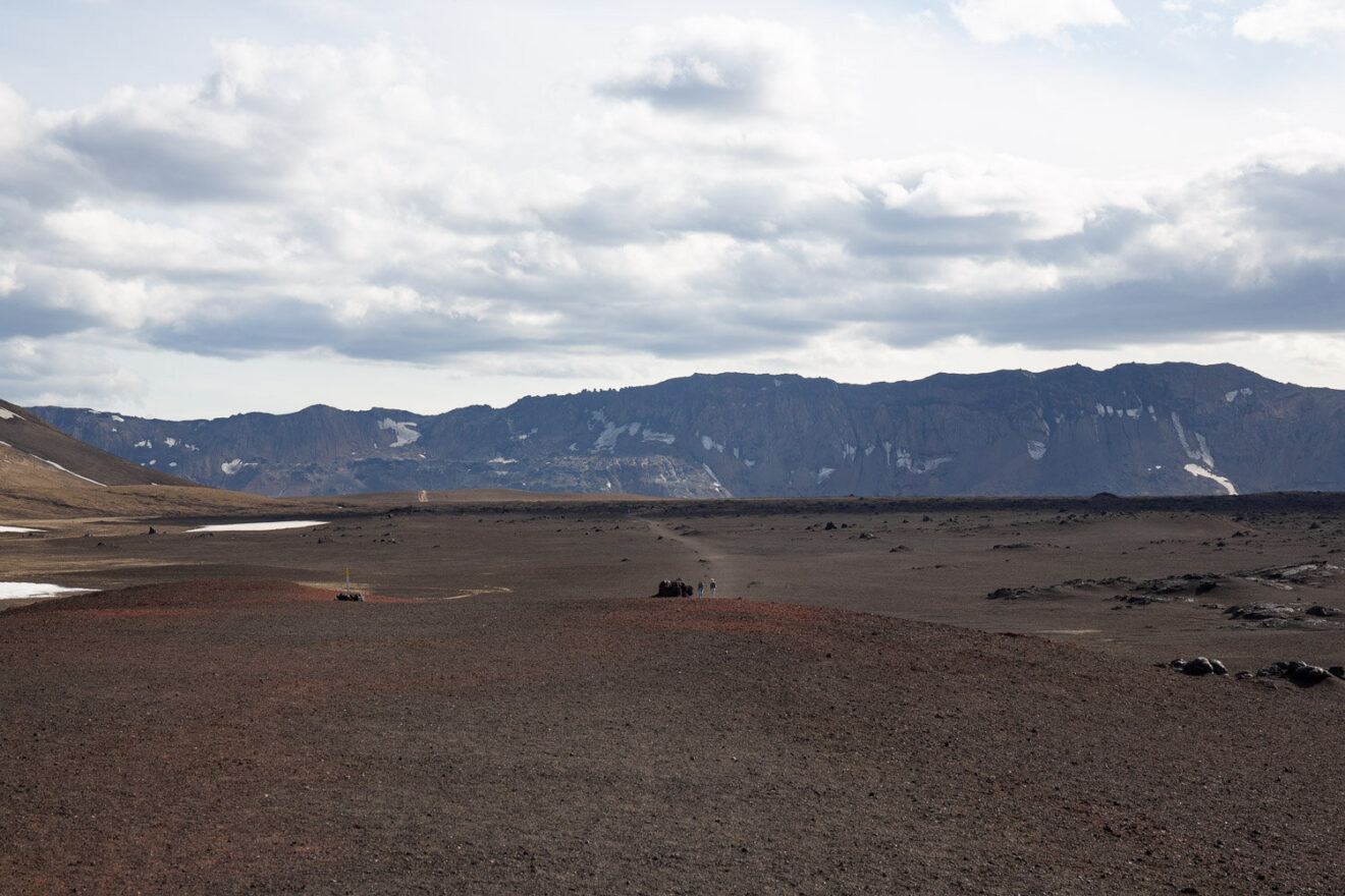
The NVZ begins immediately north (some say south) of the infamous Holuhraun eruption of 2014. There are 5 volcanic centres in the NVZ, of which Askja is the most southerly – and the largest. Askja would be a major attraction in any other region: it has an unearthly beauty, a volcanic oasis in an uninhabited lava-desert landscape with a large caldera and two scenic lakes. Quite a few tourists still manage to get there during the summer, but only after several hours of almost off-road driving. Most come on organised trips. You can get there yourself, but will need to rent a superjeep (four-wheel drive with enough clearance to get over the rubble that pretends to be a road). Be aware that you will need to ford the unbridged rivers that cross the road, preferably when the rivers are not in spate. Many pictures of Askja show the same view of the two lakes, from the same vantage point. It is close to the point where the road gives up.
Askja has had several eruptions in the past 200 years, making it a relatively active volcano with mainly basaltic lava eruptions. This post will focus on the large -and unusual- eruption of 1875. More recently there were small eruptions in the 1920’s and in 1961. In some ways the 1875-1929 activity may represent a single episode.
Since the Krafla eruption Askja has been deflating. There is no direct connection between Askja and Krafla, although they lie along the same rift. Inflation at Askja resumed around 2010. At this time the lake became ice free, evidence of increased hydrothermal activity. There were earthquake swarms. Everything calmed down again when Bardarbunga reactivated. But since a year or so there again has been earthquake activity at Askja. This coincided with Grimsvotn entering an unexpected quiet period. Deep below the brittle crust, the volcanoes here are connected. They live off the same magma supply, drawn up through their individual conduits and stored in separate chambers. They are like different banks, dispersing the same government-issued money but with their own vaults and with different terms and conditions. If Askja is a bank, its caldera may perhaps be viewed as a ‘hole-in-the-wall’ created to dispense magma.
Inside
Inside Askja caldera
The volcano rises 800 meter above the surrounding area. Most of it is taken up by a large caldera, measuring 8 km across: in fact the word ‘Askja’ means caldera (or ‘box’). There are two more craters here. The larger one measures 3 by 4 km, has a large lake, and is young: it first formed in an explosion in 1875. Just a few meters north of this crater lies Viti crater, formed in a smaller explosion in the same event. It too contains a lake, and it is near the end point of the road. Brave souls can try to swim in it. But be aware: these lakes can kill. That is a story for later.
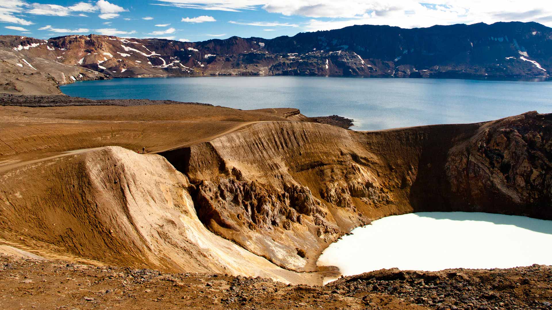
 The large lake is called Öskjuvatn. It is deeper than the main caldera. The lake is 3.5 km across; the surface is 50 meters below the caldera floor and the lake is 220 meters deep. The small Askja Víti crater is a scenic, deep hole filled with a small lake. Its lake is suitable (kind off) for swimming because it is geothermally heated. Öskjuvatn tends to be frozen and should be more attractive to polar bears than to tourists for their swimming lessons. But its water is possibly cleaner. A swim in Víti crater is certainly memorable – the stench of sulphur will cling to you for days. Stay away from the boiling vent and from falling rocks, and be aware that the slippery path is easier down than back up. In rain it may be next to impossible to get up. If a trapdoor spider would run a bank, this is what its branches would look like.
The bank of Askja
The terms and conditions of the bank of Askja are hard to read. This volcano-bank offers different products at different times and at different branches. It has eruptions at the central branch (the cauldron), in the suburbs (the ring fault and flanks), and out of town (distant fissures). The main product is basalt, but the 1875 eruption produced rhyolite – a bit like the Bank of America suddenly issuing Russian rubles from its cash machines.
Askja is a shield volcano, as might be expected from the fact that it normally erupts basalt. The caldera is enormous and it takes up much of the area of the shield. It is also remarkably deep. The main way a basaltic volcano may form a caldera is by emptying the magma chamber underneath through a distant dike. This happened at Bardarbunga which collapsed at precisely the rate at which Holuhraun erupted, leaving little doubt where the magma went. The same happened at Kilauea during the Leilani eruption. It is therefore natural to expect the same happened at Askja. The caldera is 8 kilometers wide and 300 meters deep, which gives a volume of 15 km3. The sides may have been much higher before being eroded by the ice, making the caldera more than 1 km deep. Such a large volume requires large lava fields (‘hrauns’).
Some have suggested that the caldera is a fraud. It is perhaps 200,000 years old, and for 80% or more of its life has been covered by ice age glaciers. Almost all of its eruptions were subglacial: Askja is an ice-age volcano. Effusive eruptions underneath a thick glacier form hyaloclastites and indeed much of the area around Askja’s caldera is covered in these. Lava underneath thick ice cannot flow out, but forms steep ridges above the erupting fissure. The argument is that the ridges around the caldera are hyaloclastite ridges on intersecting faults, giving the impression that the enclosed area is a caldera.
Askja is now commonly viewed as a combination of both: there was also some subsidence of the central region, but the surrounding ridges are mainly hyaloclastites, perhaps on a ring fault. The bank of Askja has boosted its appearance with a big building funded with some drastic quantitative easing.
The ridges around the caldera reach around 1200 meters in elevation, and the floor of the main caldera is at 1050 meters. It used to be deeper: there is at least 50 meters and perhaps as much as 500 meters of post-ice-age lava and volcanic debris in the caldera.

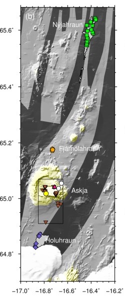
From Carey et al. 2010
The black dots show the large caldera. The lake forms an extension to the southeast, formed in the recent 1875 eruption. The centre of the new crater is on the edge of the old caldera: it used the same fault that created the caldera ridge. Shallow earthquakes (typically 2-4 km depth) now occur mainly around the southeastern edge of Öskjuvatn. This area also has hydrothermal activity. There is also at times some earthquake activity at much greater depth, up to 30 km.
Deposits
Askja is mainly, but not exclusively, a basaltic volcano with effusive eruptions both at the caldera and further afield. The largest lava fields are to the northeast, as far as 30 km for the centre of Askja. Together they contain perhaps 10 km3. There are numerous small lava flows are all around the flanks and inside the caldera. Seven such flows erupted between 1910 and 1929, fed from rifts and fissures. To the south the lava flows just reach the area of the 2014 Holuhraun lava, up to 15 km away. Askja’s rifts are lopsided, extending much further to the north than to the south. That is of course a consequence of the lie of the land: the big bulge of Vatnajokull stops the rifts going south. As they would have to flow uphill, it is a no-go area for Askja. To the north, the rifts can continue a long way, running along the side of Krafla’s rifts .
But there is more to Askja. Since the ice age there have been at least three explosive eruptions producing rhyolite. A layer of tephra up to 2 meters deep is dated to 10,000 years ago. Distant 2000-year old tephra (‘distant’ meaning that it was found in Sweden) seems to come from Askja, although it has not (yet) been found at Askja itself. The third rhyolite explosion was in 1875: it left white tephra up to 5 meters thick around the crater, and even 15 km downwind the layer was still 50 cm deep. The rhyolitic explosions produced perhaps 1 km3 (DRE) (or a bit less) in total. They were a pyrotechnic sideshow to the far more numerous basaltic eruptions .
Digging below the surface shows that Askja is more active than it may seem. This is one of the big banks of Iceland. 175 separate eruptions have been identified for the past 7000 years. This is about one eruption per 25 years. (In reality the eruptions occur in clusters, and the clusters are further apart.) In Iceland, only Grimsvotn erupts more often than that, whilst the rate is similar to that of Katla and Bardarbunga. Since the ice age, Askja has produced at least 40 km3 of lava. Not bad for a bank – Askja is a decent volcanic investment. More than half of the caldera floor is covered by lava flows younger than 1510.
The 1875 explosions
The 1875 explosion is a warning not to take this volcano for granted. In fact, the crater lake already indicates there is more to Askja than a friendly fire. Any crater lake should be viewed with suspicion. It means that something made a big hole, recent enough that it has not yet been filled with sediment. The water makes a volcano even more dangerous than it already was. Iceland has two such large lakes: Öskjuvatn and Grimsvotn. You have been warned.
Öskjuvatn formed in the third largest rhyolitic explosion since Iceland’s settlement. This is the oldest eruption at Askja where we are certain of both the date and the time. The eruption column was seen throughout Iceland.
The explosive eruption on 28/29 March lasted 17 hours. It started with phreatic precursor activity (i.e. steam clouds were seen: ‘phreatic’ means water). At 9pm a rising column was seen for an hour (until night fell) and tephra began to fall as far as 50 km away. This is considered a subplinian explosion. A larger, phreatoplinian explosion followed at 5:30am in the early morning, lasting about 1 hour, with a column up to 30 km high. It deposited a 2 meter thick ash layer in the caldera, and send tephra as far as Scandinavia. The ash was wet and sticky. The explosion was followed by pyroclastic flows in the region. After a 30 minute pause a new vent opened and another plinian explosion followed with again a 30-km cloud, this time dry rather than wet. Even 150 km downwind the tephra was still 2 cm deep. Local tephra shows that the explosion was accompanied by fountaining from the rifts or vents.
The eruption was entirely within the area of the modern lake. The lake did not exist at the time but we know that a small pond had formed. When people came to see some time after the explosions, there were three rifts visible which apparently had been the sites of the explosions. They are indicated by the white bars in the image above, and the labels indicate the alphabetic order of the explosions.
The explosions had formed a triangular depression, but it was much smaller than the current crater. The deep crater formed by stepwise collapse lasting almost 50 years, either by magma drainage or by rifting. This ended only with the flank eruptions of the 1920’s.
The 1874-1876 rift

Source: Bryndis Brandsdottir, 1992, 42, Hartley & Thordarsson, 2013
This was a very busy time for the area. The first rumblings were in January 1873, with a large explosion at Grimsvotn. This is not particularly unusual as Grimsvotn erupts often but this eruption was a bit larger than most. Some tephra of this explosion reached Askja, and formed a layer just below the ejecta from 1875.
The first signs of renewed activity at Askja itself were early in 1874 when steam clouds were seen above the volcano. We don’t know what actually happened: no one lived close, and the nearest farmers were tens of kilometer away. Earthquakes were felt in north Iceland in the autumn of 1874, and these became stronger and numerous in late December of that year. (There had been two M6.5 earthquakes of the north coast of Iceland in 1872, but this is too far from Askja to have had any effect, and they also were on a different fault.) New fissures were found in the ground north of Askja. In hindsight, a dike had been forming from Askja running towards the north, and this had caused the earthquakes and the ground deformation. But this was not known at the time.
On Jan 2, 1875, the earthquake activity became so strong that damage occurred to some farm houses. The location of the earthquakes is not entirely clear, but the damage was most severe around the Sveinagjá and Veggjastyki grabens, 50 kilometers north of Askja and the reports indicate that the activity was centred near here.
On Jan 2-3, the earthquakes culminated with an eruption at Askja. There are no eye witness reports other than the eruption cloud, and the size of this event is not well recorded but it may have been a significant explosion which produced a notable crater. It appears that at the same time there was an eruption at Fjárhólahraun a few kilometers north of Askja, as two separate eruption columns were seen. The lava field of Fjárhólahraun has been attributed to this eruption, but it appears that this is much older, possibly from the 14th century. Tephra found at Fjárhólahraun does coincide with the 1875 eruption, and there may have been fountaining activity here but without large lava flows. After these eruptions, the earthquakes diminished but did not fully cease.
The first visit to Askja (remember this was mid-winter, with deep snow, and the area was difficult to reach) was on February 16. They found new craters in the area which is now occupied by Öskjuvatn, just outside the caldera, with intense hydrothermal activity. Remember that this was before the large explosions in March, and the large new crater had not yet formed.
On February 18, 1875, activity suddenly moved far north, to the area where the earthquake activity of December and January may have been focussed. A rift eruption now occurred in the Sveinagjá graben with actual lava. A second site in this graben erupted on March 10, a third one on March 18 and a fourth one on March 25. There were eruption sites along the entire graben, although each seems to have been short-lived. A report from March 25 describes 40 active craters. This sounds more like a continuous fissure which did not develop a single dominant cone. The eruptions here produced the Nyjahraun lava field.
The next event was the major eruption at Askja of March 28/29 which has already been discussed and which affected much of eastern Iceland.
After this event, the main activity continued to be at Sveinagjá. Eruptions here were reported on April 4, 10, 24, July 2, August 15 and October 17. Weaker activity may have continued into 1876 but this was winter when it was difficult to visit. Askja itself also had some activity, with an eruption cloud on May 19, and unconfirmed reports of further activity and in the autumn and winter. In early 1876, the action ceased.
The magma vault
It is interesting that the main activity was not at Askja, but 50 km north in an area with rifts but no central volcano. It was a fairly normal fissure eruption, with lava erupting from separate locations along an extended rift. During this time Askja had hydrothermal activity and major explosions, but less evidence for lava. The eruptions seem related but they were quite far apart. Did the activity come from Askja? Or was Askja just a side show?
The composition of the lava and tephra show a relation between the two events. However, they are not identical. Whilst the tephra at Fjárhólahraun is identical in composition to that at Askja and clearly comes from the same source, Nyjahraun’s composition is a little different. It appears that the new magma mixed with an existing magma reservoir at Askja, but at Sveinagjá only the new magma erupted, not the mix.
The earthquake activity provides a second clue to a connection. The December and January earthquakes (which may have reached M5.5) were focussed on Sveinagjá. But it diminished after the January eruption at Askja. The earthquakes indicate a dike was growing, but it stopped growing after the pressure had been relieved at Askja. From this point the magma underneath Sveinagjá was trying to find a weakness to the surface. This took 6 weeks. After this the activity continued intermittently for a while (9 months) but eventually petered out.
We can speculate on what had happened underground. New magma had begun to collect underneath Askja, initially at a depth below the brittle crust. From there, in December a dike formed towards Sveinagjá. The earthquakes traced where it entered the brittle crust, near Sveinagjá. There was no reported activity in between Askja and Sveinagjá.
While the dike was forming, the magma also began to interact with an existing shallower magma chamber underneath Askja. The interaction rejuvenated this stale magma, by heating and mixing. This rejuvenation caused the rhyolite explosion of March, and also pushed some of the magma through an existing fault towards Fjárhólahraun.
The explosion removed the pressure below Askja, and the dike now no longer received an inflow of magma. The magma at Sveinagjá was still pushing up, and this caused several eruptions along the entire length of the graben. But without new magma they lost their oomph, and finally ceased after 9 months. This model is speculative but seems to fit the events.
Traditionally there have been two ideas for how rifting eruptions occurred. In the first idea, magma was assumed to collect underneath a central volcano, and a dike extended sideways from this chamber under a shallow or steeper upward angle. Where the dike reaches close to the surface, extension occurred and magma began to rise to the surface probing for the weak spots. The second idea began with the rifting, allowing deep magma to rise vertically into the vacated space. Here each part of the rift in a way has its own magma supply, albeit all are connected at depth.

Illustration of the two main models. A third model is like the one in part a), but with a second, deeper dike flowing from the deep magma reservoir. Hartley & Thordarsson 2013
The second version has not received much attention recently. The well studied rifting eruptions in Holuhraun and Kilauea left little doubt about where the magma came from, and this fitted the first idea. The Krafla eruption (close to the 1875 activity) also operated in this way. However, the first idea may not be perfect. If the main magma chamber underneath the central volcano is fairly shallow, then a dike may form below it, bypassing this chamber. It seems plausible that Laki formed in that way. For Askja also, a deep dike well below the main magma chamber may have intercepted some – or most – of the new magma and diverted it 50 km away.
The reason for the explosive activity is that Askja had been inactive for some time, perhaps centuries. The magma chamber had gone stale but not solid. These are the most dangerous volcanoes.
The final question is why the explosions were both wet and dry. Some of the activity was in standing water, and some was on dry land. It appears that water had ponded in the depression (caused by the rifting?) but not everywhere.
Holuhraun
Before 2014, Holuhraun was seen as part of the Askja rift system. This is relevant here because there are two lava fields in this area dating from around 1875. These have at times been considered as part of the Askja eruption. Of course, nowadays we know that this area is under different ownership, and is within reach of Bardarbunga’s rifts.
The two lava fields are conveniently called Holuhraun-1 and Holuhraun-2. They erupted in slightly different locations: Holuhraun-1 was 15 km south and Holuhraun-2 erupted 23 km south of Askja (adjacent to the glacier). It now appears that these flows formed before the Askja 1875 eruption. Holuhraun-1 is almost a century older, and likely formed in the winter of 1797. Holuhraun-2 is much closer in time to the Askja eruption but still a bit too early: it formed around 1863. Holuhraun-2 coincided with the eruption in Veidivotn which formed Tröllahraun.
The lava of the three Holuhraun eruptions (including 2014) is identical. We can safely blame Bardarbunga. The closeness in time between 1863 and 1875 may suggest that this was a time of general rifting in the NVZ. It started from Vatnajokull, and reached as far as Sveinagjá, a length of 100 km. Askja may not have been the driving factor: it just happened to be on the rifting path and provided a convenient and existing conduit.
Öskjuvatn

Askja’s beautiful lake holds deadly secrets. Volcanologists have disappeared without trace while investigating it. That is notable in a nation where volcanic eruptions very rarely cause casualties: in one event, Askja killed as many people (2) as all other Iceland’s volcanoes have done together since.
The killings happened in 1907. Two Germans went on to the lake in boat to investigate the caldera, on July 10, 1907. They were never seen again, dead or alive.
The Germans were Max Rudolff, a painter, and Walter von Knebel, a geologist. Knebel was 27 years old at the time, and engaged. The expedition was for his research – Rudolff was there to provide the illustrations. When they did not return, Knebel’s fiancee organised an expedition to find him. The chase was not sucessfull but at least it gave her a new life as she subsequently married the person who accompanied her on the journey.

Memorial to the disappeared
Her name was Viktorine Helene Natalie von Grumbkow; she used the name Ina. Her partner in the attempt to find her fiancee was another volcanologist, Hans Reck. Ina had to proof she could do the trip (being a woman), and did so by traveling around the Reykjanes peninsula where she visited Krysuvik and Keilir – which she climbed. Having managed that journey, the two set off on a trip that went via Hekla, Laki , Myvatn and Herdubreid – the volcanology interest of Hans Reck showed – before reaching Askja.
Ina wrote a book about the failed search. Arriving at Askja, she writes
“The Askja crater has in all directions almost the same diameter of around 9 km. The diameter of the almost round lake sunk in the southeast corner of the basin and named in memory of my fiancé Knebel-lake is 4-5 km. Despite the distance, we often saw the dust from the avalanches on the south wall opposite our tents and the water splashing up on the edge of the bank when particularly large blocks had fallen into it. As already mentioned, the lake is enclosed by steep walls in the south and east. Especially on the south wall they are completely inaccessible. The over 300 m high wall here consists of a fusion of rugged almost 100 m high palagonite cliffs, the tips of which stand out sharply against the sky, with heaps of rubble that stretch from the foot of these cliffs to the lake level – the paths of the never-stopping dangerous rockfall. There is not a foot of flat land at lake level”
“On the west side, the lake is bordered by an approximately 60 m high bank. In its entire length it shows the colourful stratification of basaltic lava and coloured slag with the generally golden pumice covering in the Askja basin. The north side of the lake has the 80 m deep Rudloff crater (named after the young painter Max Rudolff who had an accident with Dr. von Knebel), at the bottom of which green-yellow sulphurous waters boil with alternatingly strong steam. The crater is very close to the lake, so only a very narrow ridge allows it to pass between it and the lake.”
After a difficult and fruitless search, the party left again, with one final look at the place where her fiancee had disappeared:
“A wonderful distant view presented itself once more from here. Towards the south the wide Askja basin, filled with black lava flows and white patches of snow, framed by multi-shaped, colourful mountains trimmed with snow. Far, far beyond, beyond the whole width of the southern Ödahraun the Vatna Jökull in light beauty. And on the whole, the transfiguring appearance of inviolable majesty, the highest solitude and original perfection. As the early morning mist melts under the rays of the rising sun, so all the glimmers of the modern world fade before the unsophisticated grandeur of this pure nature. The same word that was coined for millennia for the lilies in the field is still valid here today, in view of all this silent splendour: that Solomon in all his glory was also not clothed as this one.”
The names that she bestowed on the lake and crater have not survived modernity, but the four meter tall pyramid they left as a memorial is still there. The lake is now called Öskjuvatn, and the small separate crater is called Viti.
The in-land tsunami
At the time, the caused of the disappearance remained unknown. A popular suggestion was that they had used a poorly build boat which had sunk in the lake. But it now appears that the two Germans may have vanished because of the frequent rockfalls that Ina described.

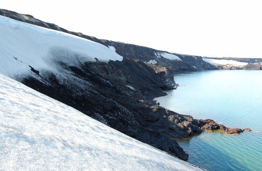
On July 21, 2014, a landslide occurred on the southeastern cliff above the lake. The cliff collapsed over a length of 800 meters, between 150 and 370 meters above the water. Half of the debris, or 0.01 km3, slid into the lake, mostly as a single block. It caused devastation. In hindsight, movement on the cliff had started 7 years earlier, and the creep had already reached 25 meters before it gave way. But no one had noticed the change and the collapse came as a complete surprise. The landslide was among the largest in Iceland of the preceding century.
The original cause was probably the long-term subsidence of the crater along the ring fault. The final collapse came after the ground had been weakened by snow melt (asn effect already described by Ina) and by heavy rain.
Luckily, the collapse happened at midnight and no tourists were present near the lake. They would have seen a frightening event, and probably not have survived. The block slid into the lake at a speed of 140 km/h, and traveled 2 kilometers along the bottom, disintegrating along the way. The block pushed up the water, and this wave started traveling out at high speed. Even lakes as small as Öskjuvatn can have tsunamis! And lake tsunamis are even more dangerous than their open water counterparts. The water bulge can’t spread out – instead the water becomes focussed towards a small area on the far side. The wave here can reach enormous heights. The run-up at Öskjuvatn along the shore reached up to 80 meters! The wave traveled at 50 m/s, and reached the opposite shore in 1 or 2 minutes. By the time people exploring the lake would have recognised this phenomenon was not put on for the tourists but deadly dangerous, there would not have been enough time for them to climb to safety.
The debris was sufficient to raise the level of the lake by 0.5 meter. But that was a minor side show compared to the lake tsunami.
Black sand from the bottom of the lake was left on shore by the tsunami, reaching heights of 60-80 meters
Ina reported numerous small rockfalls into the lake. This was at a time when the caldera was still forming through slow subsidence along the faults at the edges. The disappearance in 1907 was at the same time of the year as the 2014 collapse. This is the time when snow melt can destabilize the ground, something also noticed by Ina. The suggestion has therefore been made that the two Germans were on the lake during a collapse, and were swamped by the wave.
Final words
Askja is a highlight of Iceland, worth the effort it takes to visit, at least when the roads are passable in summer. But it is also unpredictable and dangerous. White Island has shown us the dangers of volcano tourism. The lessons also apply to this giant of Iceland’s sleeping beauties.
And activity is on the rise. Hydrothermal and earthquake activity increased in 2010, and for a while the lake even became ice free. After a calm period, earthquakes resumed last year and since a month there is rapid inflation. Magma is on the move. The inflation is centred not at the new crater of Öskjuvatn, but at the centre of the old caldera. This is a significant influx. Will there be an eruption? Will it be in the caldera, along the surrounding ring faults, to further away? Will the bank of Askja collapse? It is far too early to call wolf. But perhaps it is a good thing that the tourist season here is ending.
references
Gylfadóttir, S. S., et al. (2017), The 2014 Lake Askja rockslide-induced tsunami: Optimization of numerical tsunami model using observed data, J. Geophys. Res. Oceans, 122, 4110–4122, doi:10.1002/2016JC012496.
Hartley, M. E., and Thordarson, T. (2013), The 1874–1876 volcano-tectonic episode at Askja, North Iceland: Lateral flow revisited, Geochem. Geophys. Geosyst. 14, 2286– 2309, doi:10.1002/ggge.20151.
Carey, R.J., et al. (2010), Tephra dispersal and eruption dynamics of wet and dry phases of the 1875 eruption of Askja Volcano, Iceland. Bull. Volcanol. 72, 259–278
Hartely, M.E., et al. (2016), Postglacial eruptive history of the Askja region, North Iceland.Bulletin of Volcanology 78, Article 28
Brandsdottir, B., (1992), Historical accounts of earthquakes associated with eruptive activity in the Askja volcanic system. Jokull, 42, 1
Ina von Grumbkow, 1909. Ísafold: Reisebilder aus Island. http://www.isafold.de/klassiker/default.htm
Albert, September 2014


17:46 massive fountaining.
19:48 too with some fountaining
For any of you that are spanish speakers this, I think, is an interesting interview with one of the volcanologists monitoring la palma situation, and also a little bit about el hierro:
Will be a small Basanite eruption If it happens .. but fun anyway
Really great, thank’s!
The swarm is still going right?
https://www.ign.es/web/ign/portal/vlc-senales-sismicas/-/senales-sismicas/getDetalleDia?diadetalle=2021-09-16&estacion=PA01&tipoFO=2&tipoSP=2
Wow looks like We are going to get an alkaline eruption after all?
seems to get weaker over time, so probably it is going to stay there
😞😞😞😞😞
No eruption then..
But magma supply is insignificant there
Video from the path down to Natthaga, lava is flowing down again…
https://youtu.be/SuQJXTDIgXs
This might be quite fast to fill Natthaga up once the path is established properly
Indeed. And isn’t this shot from Mila’s Reykjanes cam just wonderful?
This one is also pretty heart warming (view from Natthagi towards Geldingadalir):
(this is Natthagi mbl cam)
Hmm, this is wide area surface flow, a lot of the lava will stick to the upper parts of Geldingadalur. It will take weeks to fill up Natthagi this way – which is great news for the road and for tourism.
But the way it is flowing right now also carries high risk of building up the slope and creating a ath that crosses over the barrier to Natthagikriki relatively quickly. Which would be not so great.
The Gervitunglamyndir still webcam shows a perched channel building not far from that wall, it would only take a few breakouts to fill the space to the wall.
http://brunnur.vedur.is/myndir/webcam/2021/09/17/webcam_storholl_leidigardur_S.html
Very impressive, thanks!
Evidence that Mars once had 1,000’s of super volcanic eruptions – https://strangesounds.org/2021/09/mars-experienced-super-eruption-arabia-terra-video.html
Very interesting article on how scientists changed their mind about some craters on Mars caused by meteors, to craters caused by super-eruptions of volcanoes.
And another upgrade for Ingenuity to allow it to fly in lower upcoming seasonal Martian air density. – higher peak rotor speed 2,800 rpm. Fingers crossed.
https://mars.nasa.gov/technology/helicopter/status/334/flying-on-mars-is-getting-harder-and-harder/
First test flight with higher rotor speed as early as Friday all going well.
From the Mars eruption link – Nice to see Mars also uses the Inter-Galactic Standard Volume unit 🙂
‘Olympic size’ on Mars refers to a different mountain though. So this is 400 million times Olympus Mons which is very roughly 10^15 km3, or a VEI 20. So that can’t be it. The swimming pool must then refer to the caldera, which has a volume of 10^5km3. That gives me 4 10^12 km3, which is only a VEI 17. That must be it. It is also 200 times than what remains of Mars now. Wow. Is it perhaps possible that NASA got its numbers slightly wrong? They have had problems with unit conversions before.
The current view on the Natthagi MBL camera at the momnet with lava spilling into the valley is quite stunning.
at 21:11 pm the cascades of lava seem to be picking up steam
That quake has been removed from IMOs list, apparently.
Herdubreid(artögl) does its thing for many years now. There are interesting articles on this unrest in the VC cellars.
https://www.volcanocafe.org/seismic-unrest-and-the-future-of-volcanism-at-herdubreid/
See also the comments!
Adrej Flis did a nice 3D animation on the area’s quakes 2004 – 2017 that reveals southwest – northeast alligned fissure (or fault system my guess) zones with activity. Also the Upptyppingar intrusion is visible.
https://youtu.be/gvOSH70iCIY
Long term increasing activity around Askja is interesting
Some years back there was a project which revealed there are many more minus 12 km microquakes under Askja than IMO has been preceiving. Another sign of magma moving.
I’ll try to dig it up and link it.
Sorry, meant as repond to Lakigigar above.
https://www.volcanocafe.org/askja-1875/comment-page-2/#comment-75704
https://m.youtube.com/watch?v=jWdVY9QaLhA&feature=share&fbclid=IwAR3uhJQlhLqd4VEQvbkhz-g8I1Izi7xfi-ZpgtNamQm_OUo0SLdjXuMgeYA
Webcam
This is mbl Natthagi cam
Albert, I’ve been busy and have only just had time to read your post. Really interesting and, like others, I enjoyed the blending of the human and the scientific. Thank you.
Hey all. The Mila reykjanes webcam looks a little worrying here
https://www.livefromiceland.is/webcams/reykjanes/
Lava showing clearly hot and flowing near the trail a berm, it looks closer than ever to overflowing. And lots of people still going up trail a in the dark as can be seen by all the head lamps. Shows how hard this must be to police in the dark. It looks like a horrible accident waiting to happen.
Mel camera from across Natthagi https://www.youtube.com/watch?v=jWdVY9QaLhA @22.56 camera time, seems to show lava collecting behind berm too. Wouldn’t be surprised if it overtopped during the night
Massive lava dump over the edge into Natthagi just after 0031.
https://youtu.be/jWdVY9QaLhA
Here’s what appears to be a ground-level view of the event.
https://www.youtube.com/watch?v=FHQAxqJc7m0
Doesn’t looks like a place to stick around… Filmed from across the valley, perhaps?
Good use of that “NYAP NYAP” song there.
Is La Palma still shaking?
GutnTog says he’s running away from descending lava floods.. I guess I would too – https://www.youtube.com/watch?v=5AV2KSpVeJE
Turns into Aa instantly downhill because of stress .. its also likely that this lava is stored and a bit cooler compared to the lava that is up in the main vent now
But Geldingadalir lava lake is well insulated for soure, so cooling is perhaps non existent
It will take decades, 100 s of years for the shield to loose all its heat it the eruption stops..
And If the eruption continues and the shield grows even more, that Only adds more insulating hot materials.
Im soure that the really Big Monogenetic shields in Iceland may still be hot inside in their thickest parts
Hey Jesper I found that info very interesting. Makes me wonder if the visitors to the site because some clowns think it’s ok to wonder over the lava crust.
Meant to say better educated on the dangers…
I have walked over lava crust many times in Hawaii
Fagradalshraun is made of gassy pahoehoe lava ”shelly pahoehoe” So it pretty much crush to glass under the boots .. There are also big gas hollows voids and mini lava tubes that you can break into .. the smooth looking stuff is sharp as glass
Degassed pahoehoe flow fields are easier to walk on .. But still razor sharp When Fresh
Yes how true- my vision is falling into a still hot cave.
Yes thats scary for soure! And maybe Only a thin shell above souch orange hot void
Yes defentivly possible to fall into fagradalshrauns hell caves
Crash.. and you are gone .. one must be extremely careful where one walk there
Some excellent footage from the 15th showing increasingly ragged inner volcano wall above the vent and the lay of thje land around the kritiki berm.
https://www.youtube.com/watch?v=DedKOJN-QEk
Whooohooww that is some HQ footage!
Those small lava falls are looking absolutely gorgeous!
Now that video provides an overview of the entire situation, as I wanted to see 🙂
Greetings =)
From all the videos I have see today, it looks like that lava flood vent never stopped, it is now flowing as an open channel all the way to Natthagi. The lava flows down the hill were because it got ponded at the top and broke out but now the flow seems sustained past there.
Not sure how much lava is actually in Natthagi right now but I imagine a substantial amount. This is where the luck runs out for the wall, seeing how much the land built up in Meradalir before, that entire slope of the mountain will be lava by October…
It will be Icelands own 61 G flow
I hopes for it to form a tube .. so the pahoehoe can be happy and reach the ocean
Is La Palma still shaking?..or have it stopped
It’s still shaking, any downtrend in seismic activity doesn’t mean that the intrusion is getting weaker it might just mean that the systems pathways are more open then before
The earthquakes are getting shallower 4km 3km 1km since 04:00 and the activity has picked up from 06:40.
https://www.ign.es/web/ign/portal/vlc-senales-sismicas/-/senales-sismicas/getInfoDia?fecha=2021-09-17&tipoFO=2&tipoSP=2&estacion=PA01
http://www.ign.es/web/resources/volcanologia/tproximos/canarias.html?fbclid=IwAR3GEqfr-AJg4p18QS_fWpPmSxss6-_xwEAQJjv-33JqoKCac_KxSOqQ0A8
Look at how the villages are placed directly under Cumbre Viaje.
https://imagenes.heraldo.es/files/image_990_v1/uploads/imagenes/2021/09/15/varias-personas-suben-al-mirador-de-cumbre-vieja-una-zona-al-sur-de-la-isla-que-podria-verse-afectada-por-una-posible-erupcion-volcanica.jpeg?fbclid=IwAR06S17QE_RA3-1QQai3ZiIQwinBIPjT9leI-oCPROcZ4960MbvvJFdKKSE
those shallow quakes are probably related to stress in the volcano? and not the presence of magma at shallower depths.
I think it is over for now maybe it will resume in a couple of days.
I am confused are these signals (stronger and wider ) not earthquakes because cannot find them on the the Ign list .
Jan I think those might be man made signals, they always appear from 6am to 22pm and also are there even when no swarm is happening you can pick any day and they are still there, for example from a random day in july:
https://www.ign.es/web/ign/portal/vlc-senales-sismicas/-/senales-sismicas/getInfoDia?tabResult=Todas%20diaria&tipoFO=2&tipoSP=2&chooseDate=Fri%20Jul%2016%202021%2000:00:00%20GMT+0200%20(hora%20de%20verano%20de%20Europa%20central)&estacion=PA01
@ Charly91;
IMHO, you are correct that those are manmade signals. Good catch.
My personal hunch as to what they *might* be depends upon the location of that seismograph. If it’s on the northern flank of Cunbre Vieja, I suspect truck traffic through the road tunnel that goes through that face of the volcano (so far as I know, it’s the only road tunnel in the world that goes through an active volcanic edifice).
That is very bad for soure with souch steep slopes and low sillica Basanite lava. Eruption rates will be quite fast too. It will flow very quickly for soure down the steep slopes
With luck, the Basanite will be cool and quite viscous ..like Etna
But it coud also be very fluid .. and go ridicolusly fast Aa down these steep slopes.
Even if the lava is viscous .. it will be leathal with the Rolling Aa lava clinkers blocks that will roll down these steep slopes, Not a tourist eruption If you are below the vents!
Guayota La Palma
http://www.involcan.org/guayota-la-palma/
I’m afraid I don’t understand all that gobbledegook. Care to translate it into English?
You can click on the flag of the UK for the English version.
http://www.involcan.org/guayota-la-palma/
This link has an English Version.
No, I meant in your previous post, where you wrote, and I quote:
“?_nc_cat=100&_nc_rgb565=1&ccb=1-5&_nc_sid=730e14&_nc_ohc=ZjpcYr3HU4EAX_B0Idf&tn=LqcKW8-AD3xBRzWk&_nc_ht=scontent-lcy1-1.xx&oh=9c7e85dc602b3cada004a18d60c114d6&oe=6148BDF4”
I did not personally write that comment it was a link I copied and for some unknown reason to me it came out like that on this site.
Well, this is a new malfunction for RUV. The Langihryggur cam is now overexposed, and it seems to be getting gradually worse. :/
This is a problem of the season. The sun is shining directly into the camera at the moment. You should contact them to ask to move the sun or the volcano, to stop this happening.
Seems it would be more sensible for them to move the camera. To, say, the west or northwest border of Geldingadalir, facing the other side of the cone where all the action is these days.
Also: Sun? What’s a “sun”? I didn’t think Iceland had those. Just various degrees of clouds, fog, and rain, and in another month or so snow. 😛
Albert, while I do think that the volcano ought to be moved, I think that the current official movement of it is ill advised.
I’m referring to the parking lots. Around here, we have specialty parking in some locations. For example, bus parking at tourist attractions; in it, you get lots of buses. Likewise, cars-with-trailers parking at DIY centers; you get cars with trailers. Compact-car parking areas get loads of compact cars. Motorcycle parking; lots of motorcycles.
So what did the Icelandic authorities do? Create volcano parking lots along the coastal highway.
This will not end well.
On a completely unrelated note:
– Sometimes the word “Ragnar” is mentioned with respect to the FAF eruption. What is it?
– Some goes with just “Nar” or “NAR”. Same question 🙂
All the vents (or groups of vents) were given names on Youtube. The vent that is still erupting was a pair, which were christened Rag and Nar and when they fused, they became Ragnar. I think Nar was the dominant vent of the two. All of the names were derived from acronyms, but this one was also a nod to Ragnar (probably the legendary/mythical viking, but also Ragnarok, the chaos or end of the world of the Gods.
I see, thank you for the clarification 🙂
Ragnar is also the name of the owner of the youtube channel which is restreaming the RUV livecam feed and providing the chat.
https://www.youtube.com/watch?v=TSI_TBDzpto
Good look at how pseudocraters are formed. In this case though because it was on a fast steep flow it moves down.
Imagine the hundreds of much bigger craters on the Myvatn flows 2400 years ago, how that must have looked.
Snow on the ground at Fagradalsfjall. Winter is here. I wonder how much the snow, or lack of, will help us see where the lava is still hot? Well for as long as there is some daylight to see it in!
I think Askja erupted! https://www.volcanodiscovery.com/askja/news/141633/Askja-Volcano-Volcanic-Ash-Advisory-ONGOING-AS-OF-0820Z-OBS-VA-DTG-170818Z.html
I think Askja erupted! 🙂https://www.volcanodiscovery.com/askja/news/141633/Askja-Volcano-Volcanic-Ash-Advisory-ONGOING-AS-OF-0820Z-OBS-VA-DTG-170818Z.html
Maybe this is premature (and I don’t know where exactly this is), but here is a webcam showing some possible ash/smoke:
Source:
Oh my god. This is so amberaasing. I’m sorry, that is Kverkfjöll. How stupid.
That is surprisingly quickly, but maybe it means this will be a minor eruption?
Tremor looks quiet. Blue well below the other colors:
Out of date, or has someone jumped the gun at VD?
Just to clarify about VD, the VAAC reports are automatically added by the site, not by people. That also usually causes the VD (unofficial) alert status to jump up to orange automatically (if not already there or higher), that’s where we intervene if it is actually just an exercise. For Askja, I manually forced it to stay at yellow status.
It is kind of annoying, but note that only Tom Pfeiffer can make changes to how the site works (looks like he might have done now), I and others who contribute can only post news articles and change the alert status. I posted VD’s reports on Askja and La Palma being officially raised to yellow, I haven’t done many actual reports for quite a while, but I do regularly review alert statuses and change them when necessary, these may or not reflect the official alert level e.g. I put some of the Indonesian volcanoes on green though officially they are yellow (but probably shouldn’t be based on actual activity).
STATUS: EXER
Exercise?
Oh you’ve got to be $#!%[<! me ):
I’m going to wear a paper bag on my head for the rest of my life.
Easy to make that mistake. Usually the word exercise is included in the eruption details and often in other data fields as well. This time it just said:
ERUPTION DETAILS: ONGOING AS OF 0820Z.
Compare with the latest Grímsvötn exercise:
ERUPTION DETAILS: CONFIRMED BY CAMERAS STARTING 11/1420Z EXERCISE
This time it fooled volcanodiscovery.com and the exercises usually tend to fool someone into reporting in the comment section here at VC. Next time you know that you should read the report more carefully. 😉
Don’t I didn’t know such test were done, 10 out of 10 for making a call in anycase.
Please don’t be too hard on yourself. I made a huge mistake with the vertical displacement on the Alaska quake, making it 0.3 km, instead of 3 meters, and posted here on VC, making a complete fool of myself. I was wrong about the moss fires too, being started by hot volcanic gas emissions, instead of red-hot tephra fragments. The important thing is admitting that we do make mistakes and moving ahead with life.. after all, that’s life!
If it makes you feel any better, there was a false alarm for Salak volcano in Indonesia a while ago, where the VAAC mistook a suspicious-looking weather cloud for an ash cloud, and without checking for official confirmation of an eruption, I posted an urgent news report of a major, high-level eruption on VolcanoDiscovery, and changed the alert status to red (erupting).
After a while of there being no official word, I started to doubt myself and posted another report about the uncertainty. I then saw official confirmations from VSI and the VAAC that it was a false alarm, and I had to post yet another report saying this, and putting the alert status back to green.
Now, when posting news reports, it automatically gets tweeted out. The first post got a reply from someone near the volcano, asking if it was some kind of joke/hoax. Oops! Learned my lesson LOL!
Why is the volcanohead doing that?
That figure is fun as heck: you drawed it by yourself right?
Well. I hate the fake news, the hysterical overreactions, and the nonsense multiplication by copy and pasting in the social media. Now I did it myself, posting a not even related webcam picture to a non-real Askja eruption. Sigh. As Tomas suggested, next time I’m more careful.
Yep, exercise!
“VA exercise on Friday 17th September 2021
Please be aware that on Friday 17th September London VAAC will be taking part in a Volcanic Ash (VA) exercise and that VA products will appear on these, and linked, pages.”
https://www.metoffice.gov.uk/services/transport/aviation/regulated/vaac/advisories
Perhaps that website has been updated, but it (now) reads:
“There is NO ERUPTION Volcanic Ash Advisory Center London (VAAC) issued the following report as an exercise only:…”
Also, there’s nothing on IMO.
Oops! Scroll down before posting. Sorry, guys.
Yes, exercise
VA ADVISORY
STATUS: EXER
DTG: 20210917/0928Z
VAAC: LONDON
VOLCANO: ASKJA 373060
PSN: N6503 W01647
AREA: ICELAND
SUMMIT ELEV: 1516M
ADVISORY NR: 2021/012
INFO SOURCE: ICELAND MET OFFICE
AVIATION COLOUR CODE: RED
ERUPTION DETAILS: ONGOING AS OF 0820Z
OBS VA DTG: 17/1000Z
OBS VA CLD: SFC/FL200 N6504 W01742 – N6600 W01620 – N6508 W01501 –
N6425 W01642 – N6504 W01742 MOV NE 10KT FL200/350 N6515 W01726 –
N6610 W01602 – N6527 W01453 – N6429 W01618 – N6515 W01726 MOV NE
20KT FL350/550 N6515 W01726 – N6621 W01547 – N6540 W01428 – N6430
W01619 – N6515 W01726 MOV NE 30KT
FCST VA CLD +6 HR: 17/1600Z SFC/FL200 N6526 W01807 – N6935 W01227 –
N6520 W01214 – N6433 W01651 – N6526 W01807 FL200/350 N6449 W01734 –
N6954 W01401 – N6845 W01107 – N6506 W01135 – N6415 W01305 – N6449
W01734 FL350/550 N6511 W01720 – N7006 W01400 – N6839 W00923 – N6707
W00852 – N6434 W01625 – N6511 W01720
FCST VA CLD +12 HR: 17/2200Z SFC/FL200 N6519 W01811 – N7229 W01117 –
N7123 W00919 – N6542 W00753 – N6411 W01616 – N6519 W01811 FL200/350
N7309 W01424 – N7341 W01209 – N7232 W00710 – N6507 W00748 – N6435
W01727 – N7309 W01424 FL350/550 N6507 W01730 – N7335 W01311 – N7323
W00438 – N6903 W00201 – N6434 W01653 – N6507 W01730
FCST VA CLD +18 HR: 18/0400Z SFC/FL200 N6628 W01913 – N7526 W01037 –
N7433 W00647 – N6832 W00206 – N6351 W01601 – N6628 W01913 FL200/350
N6622 W02013 – N7621 W01912 – N7956 W00203 – N6841 W00105 – N6426
W01710 – N6622 W02013 FL350/550 N6557 W01802 – N7729 W01422 – N7849
E00014 – N7051 E00737 – N6438 W01708 – N6557 W01802
RMK: ASH RICH PLUME OBSERVEDUSRING GROUND BASED RADAR UP TO 20KM
EXERCISE EXERCISE EXERCISE
NXT ADVISORY: NO LATER THAN 20210917/1514Z
People getting wedding photos on the Natthagi camera now. 🙂
Never seen the air there so clear!
The lava flow is now just as tall as the berm on path A, just not right up against it. Took just a day, I would not be surprised if it only lasts one more.
I think it has flowed past the wall if you look at the Borgarfjall static camera. It is flowing into Natthagi from there at the moment as far as I can tell, but there is now access to Natthagakriki from there, down a steep gulley that splits between the two.
Now that Ruv is exposed correctly again, it’s been regularly panning to look at this area. The hilltop is getting repaved, it must only be a matter of time before it goes down the back.

There’s a great shot on the stillcam
http://brunnur.vedur.is/myndir/listi/webcam_borgarfjall_natthagiNNA.html#
That’s clearer than the view I saw. It looks like the saddle is too high for it to get over looking from that angle.
https://maps.acme.to/gos/slideshow.php?getcam=webcam_borgarfjall_natthagakrikiNA
I think there’s quite a lot of dead ground between the lava flow and Borgarfjall, so it’s hard to see how near the lava is to going over the col from this angle.
Looks like a new burst of lava is coming down the slope into Natthagi on the RUV cam (when it pans around) now.
Since people unofficially name features, I modestly suggest Lava Lake Fag, Lava Lake Formerly (known) As Geldingadalir.
http://brunnur.vedur.is/myndir/listi/webcam_meradalahnukurSSV.html#
Somethng’s blocking the view at 12.00 noon…
Cool picture. In the next frame you can see depressions from the wheels where it landed, footsteps from the person on the ground walking to the door and some rocks that have shifted position.
And the reason we can see it so clearly is because the person on the ground did a good job cleaning the lens.
Captured by the neighbour as well, albeit not quite as well
really short camera exposure to catch those tail rotor blades in action. Less than 1/1000 second?
I expect this picture was not accidental
That’s pretty cool. Perfect timing.
Wow. Not complaining
It looks like the lava is beginning, or may be about to begin, to run down into Natthaggarkriki from the col. See this webcam, which, I think, is on Thorbjorn: https://www.livefromiceland.is/webcams/reykjanes/
Don’t think so. If we look at the 3d model we see that the most probable overflow will happen at the upper dam, where the slope isn’t that steep and lava can accumulate. But the region around the upper dam is pretty visible from the Borgarfjall cam and doesn’t show a drop of lava on the wrong side of the levee.
https://maps.acme.to/gos/slideshow.php?getcam=webcam_borgarfjall_natthagakrikiNA
I think the weakest spot actually is a bit down the slope. There is not much height there towards the trail. If a new flow follows the wall down it might climb over the trail there.
Yes, I hadn’t checked the latest 3D model, but having just found the one from 9/9, I agree: as of that date, the lava would have had to climb quite high to get over the col, and I agree about the upper levee, too. And if JanB has a spot slightly downslope of the levee in mind, I agree with him/her, too.
We’ll have to wait for daylight to check the Reykjanes camera with the 3D model in mind (I’ve been away from my computer since my earlier post), but there’s been so much lava flowing down out of Geldindagalur in the last few days that I would not be surprised if the lava level has risen at the point where it crosses the path. On this conjecture, the lava would be becoming more viscous and accumulating where it does the dog-leg, and then – eventually – flowing W over the col. So I think it’s possible that a breakout could occur there, and that that’s what the Reykjanes cam is showing.
GutnTog in a video which he posted yesterday was surprised by what the lava was doing at that point, but it was hard to make out from his pictures and from his commentary precisely what was going on. Anyway, we’ll all watch and learn.
Is the Canaries swarm still alive?
Looking at data .. the drop in Earthquakes are massive now compared to last weekend
Perhaps it will fail altogther
Seems to be over, at least for now, inflation continues but at a much slower rate according to the last reports.
I guess we would need to wait a couple of days before calling it off completely, but it really seems to over, if no other pulse of magma arrives this should quite down soon, i think
Thank you very much Charly for your explanation to me on my query about the signals.
you are welcome!!! i just couldnt reply directly so i had to squeeze it somewhere haha
M2.3 quake now at 6Km…
Great minds think alike . 🙂
The snooze maybe over a 2.3 mg earthquake at 6km depth.
http://www.ign.es/web/resources/volcanologia/tproximos/canarias.html?fbclid=IwAR3GEqfr-AJg4p18QS_fWpPmSxss6-_xwEAQJjv-33JqoKCac_KxSOqQ0A8
I don’t know what are your datas, but inflation rate is not slower; vertical inflation is now at 10 cm.
It’s early to say that the situation is calmed down.
I know by calmed down I was refering to the earthquake activity, at least for now (which is what we saw the 2-3 days before the el hierro eruption, so I guess it does not mean much).
In general the situation seems to be less quakes but shallower ones, lower inflation rates, but at point that may indicate a shallower “point of pressure”.
I fully agree it is very early to make conclusions.
the report in spanish:
https://es-es.facebook.com/VolcanesCanarias/photos/a.136153813212974/1927841077377563/?type=3&theater
Ugh.. This is souch a weak hotspot compared To Hawaii and Iceland
Even Galapagos is MUCH stronger
Canaries is a huge failure in volcanic productivity
All of Icelands entire huge mass is a bit younger than Teneriffe! and
most of Big Island is much much much less than one million years old
I hopes this swarm will make a show
Has something changed La Palma.
The tremor is more energetic on live data… another M2
Thank you and no depth has been registered.
The depth is near surface… but it can be updated…
And an M2.6 just now.
Now a M 2.6 at 8km depth.
I do not think that we are seeing a tremor. I think those “tremor like” signals may be the result of some machinery or other human activity in the area. They are visible every day from 6h- 23h. You can check any day back of the year and in most cases you can see them too, an example from march;
https://www.ign.es/web/ign/portal/vlc-senales-sismicas/-/senales-sismicas/getInfoDia?tabResult=Todas%20diaria&tipoFO=2&tipoSP=2?diadetalle=2021-09-17&chooseDate=Wed%20Apr%2014%202021%2000:00:00%20GMT+0200%20(hora%20de%20verano%20de%20Europa%20central)&estacion=PA01
The right graphic show a clear tremor rise and it’s not from human activity
https://www.ign.es/web/ign/portal/vlc-senales-sismicas/-/senales-sismicas/getInfoDia?fecha=2021-09-17&tipoFO=2&tipoSP=2&estacion=PA01
I am not yet entirely sold on the idea of volcanic tremor being detected, there seems to be always a rise in the spectrogram during the working hous of each day, what makes this one different?
Do we see some typical sign or frequencies that are related to fluid movement in depth?
https://www.ign.es/web/ign/portal/vlc-senales-sismicas/-/senales-sismicas/getInfoDia?tabResult=Todas%20diaria&tipoFO=2&tipoSP=2&chooseDate=Wed%20Apr%2007%202021%2000:00:00%20GMT+0200%20(hora%20de%20verano%20de%20Europa%20central)&estacion=PA01
What have changed?
Is it still alive then?
Of couse it is!
http://www.ign.es/web/resources/volcanologia/tproximos/canarias.html?fbclid=IwAR3GEqfr-AJg4p18QS_fWpPmSxss6-_xwEAQJjv-33JqoKCac_KxSOqQ0A8
https://www.ign.es/web/ign/portal/vlc-senales-sismicas/-/senales-sismicas/getInfoDia?fecha=2021-09-17&tipoFO=2&tipoSP=2&estacion=PA01
last Vicente Soler update about La Palma:
Thanks had ot seen this one!!
What does the old man say?
Translate!
Why is the Langihryggur cam now stuttering constantly and blinking on and off?
why do you only ever come on here to complain? No-one here is responsible for the webcams!
because it’s Friday
They’re onto you! Time to move town and hide again.
Screen shot from https://www.livefromiceland.is/webcams/reykjanes/
Can you explain the picture please?
I was suspicious from one of the Borgarfjall cameras, but the other Borgarfjall one shows it is still blocked by the wall where the weak point is.
http://brunnur.vedur.is/myndir/listi/webcam_borgarfjall_natthagiNNA.html#
Pat, lava is looking into the other valley, Natthagakriki, trying to make up its mind whether to take the plunge or not.
I see. Well that is exciting. ty.
Exciting for us, Yes, but not for residents of Grindavik or all those people (Grindavik and Reykjavik) who get power ?and hot water from Svartsengi… That’s the worry about lava flowing down into Natthagarkriki, on my understanding of things.
RE:”Exciting for us, Yes, but not for residents of Grindavik..”
Ditto! Just finished watching the ‘Down to Earth’ segment on Iceland, in particular their use of geothermal and hydro-energy. The posts and comments on the various groups on Facebook make this sound like ‘Woodstock’ ’69, with all the ‘can I get a ride’, ‘what’s the best path’, and will it last until I get there’, yada yada. However the potential impact on a segment of Iceland’s infrastructure, which was the subject of great conversation some months ago had taken a back seat as to what hill will succumb next. Time to wake up and smell the burning coffee.
Svartsengi power station provides heating and electricity foe the region, plus its outflow created the Blue Lagoon, one of Iceland’s top tourist and recreation sites. Losing those things would be devastating for the region, and also bad for the country. I certainly hope it does not get that far; the power station is about four and a third miles from the berms. I have no clue, though, as to the contours of the intervening topography, so I don’t know if this is a risk or not.
Losing the coast road would be bad, but I think it would be far preferable than the lava heading west to Svartsengi, and perhaps Grindvik itself.
Lava wont be able to flow to Grindavik for years if the current activity style holds, good to make shields but the lava wont flow so far. It is if the eruption goes to sustained flows that we get tube fed pahoehoe, that can possibly reach these important areas but will take some time.
That being said it might well have just done this, the current flow has been going for several days, though to say it is a long term change to the behavior of the volcano is rushing a bit.
Looks like Geldingadalir is full of lava
Feed here https://www.youtube.com/watch?v=j2CZnBo_EVQ currently, 21.00 Iceland time, has a local photographer live streaming from the new cauldron. There’s a lot of lava and it’s fast!
But, where is the lava going ? Not much going into Natthagi, certainly not as much as is flowing out
If the lava is just pooling, that is going to be one hell of a flood when it goes. I wouldn’t want to be anywhere near that path up
I agree. It feels like it’s pooling up against the berm, which could be quite messy at some point.
But I think there is maybe more going down to natthagi than we think, as there is glow at the bottom, and could some be getting down invisibly through old tubes into the Natthagi lava lake?
Looks like the flood is just coming over the top toward Natthagi.
Cauldron has just started fountaining a little, like it did a few days ago, and a new pool had broken out to the left of the original one.
There’s a lot of excited comments being added. But not a lot of direction to live webcams, or pictures.
Can you help by links with time stamps, or by posting a (decent) picture in the comments, please?
Multiple thanks! 🙂
There was a live stream earlier, here is the recording
_hraun.vedur.is/ja/oroi/allarsort.html is the webpage for the tremor summary images.
Is the Canary swarm still alive?
Died out now?
Dude, just look at the maps and you’ll it’s still going!
Send me the link … : )
All the earthquakes can be viewed on this link.
http://www.ign.es/web/resources/volcanologia/tproximos/canarias.html?fbclid=IwAR3GEqfr-AJg4p18QS_fWpPmSxss6-_xwEAQJjv-33JqoKCac_KxSOqQ0A8
A lot of activity today.
Canaries is a Failure of a Hotspot…
Its Absoutley weak!!
All of Icelands mass is acually a bit younger than Teneriffe acually
So Icelands and Hawaiis production is astronomicaly much higher than Canaries
I wants Canaries to erupt and give us a show.. but pretty much useless as a Hotspot 🙂
But its not as failed as Tristan Da Chuna thats pretty much dead as a mantle plume almost
https://www.google.se/maps/@28.601475,-17.8588494,17z/data=!3m1!1e3
Looks like the 1949 Basanite was very very fluid for soure, flowed over the ground like glass flood near the vent.. and the lava channel is narrow and smooth. 1949 must have been alot hotter than 1971 to explain close to vent viscosities diffrences
The berm holds, but a breakout in its direction would overwhelm it. Its well overtopped where the lava flow is now.
PS Also not an ideal place for a path if the breakout is abrupt.
The path is closed, but you know human nature…
Why do we need constant effusion for (long ranging) pahoehoe tubes to form?
Sry if stupid question :/
Regarding the snow: The air temperature showed around 5 °C, ground may have been even higher, even without any volcanic activity. Was that really snow then?
Starts with open flows and small lava channels that needs To crust over .. it takes time to form the established tunnels ( lava can flow very fast in established tubes )
But Once the effusion is constant you quickly gets an insulating crust on the flows and You gets pahoehoe
Pahoehoe favours constant effusion at quite slow rates
Lava tubes wont form. If a tube does form and flow becomes episodic again it can still work, this did happen in May and June, but generally episodic flow is not in the range of flow rate. Flow of 5 m3/s is typical, episodic flow is either 0 or goes a lot higher.
Base effusion at Fagradalsfjall is between 5 and 10 m3/s as of last measurement but I think maybe this week is substantially higher. But it isnt so high that an open channel can reach more than 1 km, so lower than the pulses a month ago which reached as far as 4 km in a few cases. Massive flows go a long way like at Laki, but most really long flows are tube fed pahoehoe.
Yes … some tube feed basaltic flows on IO are 1200 kilometers long!
One Deccan Traps pahoehoes are 1500 km long
But moster sized Aa flows can also flow many 100 s of kilometers! Columbia River Basalt haves huge uniform Columnar sheets .. that can be followed for 700 km
.. They where massive crusted deep lava channels When They where active.
But most flood basalt provinces seems to been pahoehoe
Althrough the massive
Aa flows is what made the Siberian Traps climate outgassing
I imagine that provinces were a lot like Iceland, they did both. Most of the big eruptions over 10 km3 in Iceland are pahoehoe shields, same is true in Hawaii. But you also get high intensity a’a flows on occasion, like at Laki, or Holuhraun, or Ahu’aila’au. Obviously if you scale the whole thing up the eruptions are either bigger or more frequent, so you get cumulative climate effects.
There are some massive Deccan LIP sheet flows that haves volumes of 12 000 km 3 Thats freaking 4 Vatnajökull volumes.. they can be followed all along deccan plateau as uniform thick sheet flow Aa sheets
The fissure eruptions that spawned them must have been hell on Earth …
Perhaps on the Indian Continent all dinosaurs where destroyed localy by the lava flows and gases
Deccan Traps must have exterminated every single dinosaur in India localy!
Whole forest – lands are gone up in smoke and covered by rock, and the air turns into a nightmare, the whole Indian biosphere must have been destroyed
Chicxulub was hell too ..
200 million tsar bombs at Once in energy!
And perhaps 60 000 km3 of materials sent on ballistic reentry trajectories.. heating up the planets atmosphere like an oven
Chicxlulub formed terribely hot ejecta .. rock and mountains basicaly vaporize becomes like star plasma and Earths crust waves like you throws a stone in a puddle ..
Perhaps Only Antartica was relativly unharmed from the reentering hot materials and the thermal radiation..
Antartica Dinosaurs died anyway because of the prolonged impact winter, Despite being feathery furry and with warm blood
My guess is similar to that of Chad and Jesper. I would say that low effusion rates and stability are needed. Lava tubes are relatively small so they can only carry a similarly small flow, while a large output would overflow or even destroy the tubes by obliterating the crust of the flow. Also tubes require time to be established and grow. The flow must choose a single pathway among the many that are possible, and then it will grow this pathway by erosion and inflation, make it bigger and more lasting. So it is an intricate process that can only happen under certain conditions.
I want to say thanks once more to all of you for your logical and blazingly fast explanations to my question!
Only thing that’s left, even if the crater is in pulse mode, isn’t it that at the secondary vents the flow might be way more smoothed out?
Like a large sea that gets much rain at once, and melt water in an other time, but doesn’t really care because there are pauses in between.
However during both the rain and the pauses the effluent always stays the same because that large sea is buffering.
Couldn’t we get constant secondary effusion if the volcano was to behave in a similar manner?
Re your earlier question about snow: I didn’t see what you refer to but Yes, it can snow in Iceland at any time of year. I’ve known blizzards there (admittedly, in the Highlands) in mid-summer and it would not be surprising if there’d been some flurries in Reykjanes now that autumn has arrived.
I’m not a meteorologist (or any kind of scientist) but as I understand it, it’s air temperature and air moisture rather than ground temperature that affect the kind of precipitation that occurs. So, here in the UK, in winter, if warm moist air from the SW meets cold air from the N, we get snow.
It certainly looked like flurries of sleet in the rain at times on the Langihryggur cam today.
The range of the oscillating high freq graph, i.e. the spread between the minimum and the maximum, is (almost) continuously increasing since the beginning of this regime. Does anybody have a clue why?
Looks like the eruption is doing gushers again. As I have suggested in the past the gushes are perhaps controlled by lava lake acting as a lid, which blocks the rise of buoyant gassy magma, until it eventually punches through and bursts again. Perhaps the lake has become gradually deeper so that it’s “lid effect” has increased, it if becomes too deep maybe the gushers will stop altogether like it has happened before. Of course it is hard to know for sure if there is no monitoring of the lake, data regarding the changes in the depth of the lake and the state of the fountain activity.
Thanks, that would make sense (at least to a layman like me).
The increase in the ‘thickness’ of the tremor plot (range between maximum and minimum) would fit with the lava lake getting a bit deeper. I think it happen when larger bubbles can form, because they now have more time to grow. The larger bubbles can trigger the gushers. If the hole on the side of the crater heals, the lake will quickly grow much deeper and we will go back to episodic events.
So impressive…
Depth 0.1 km ?
I’m assuming this is before any manual verification ?
Yes i think so
How intense is the swarm now?
Certainly not an open conduit system
Will be very bad If it erupts… the steep slopes, the lava will flow quickly
And even the Aa clinker will roll down these dangerously steep slopes
more than yesterday…
Are you soure?
I wants this dam thing to erupt..
Are the earthquakes also moving up to shallow levels?
Yes i’m shure, more quakes and some more shallow… if you want to follow why you don’t see the links?
They moved to shallower levels the past days if more pulses of activity continue in the next few days an eruption might hapen but the magma seems to have found a cozy spot around 6-8 km depth lets see the next few days weeks how it changes.
About Askja:
https://www.ruv.is/frett/2021/09/18/askja-med-svakalegan-sprungusveim-og-tid-gos
Brief layman’s summary?
“Of course this is great because Askja has been very well followed. Askja is one of these powerful volcanoes in Iceland. It is large and has a gorgeous fissure swarm and frequent soda.”
Otherwise it also says that the magma chamber is only 2-3 km deep.
(Fagradalsfjall:) Is there a regime change again? I know, this is too early to say, but it seems that the three graphs in the tremor plot are now stacked as before, with no more oscillations.
Yes, there has been a sudden change seen in both plots. It is still weakly pulsing but more noisy during the quiet periods. A bit like a open pot of water being brought to the boil going from small bubbles everywhere to the hexagonal convection that you see just before boiling begins.
New post is up! Hector dissects the 1949 La Palma eruption
https://www.volcanocafe.org/cumbre-vieja-and-the-san-juan-eruption-of-1949/
Ma Nature doesn’t like it when you call Her useless…:-)